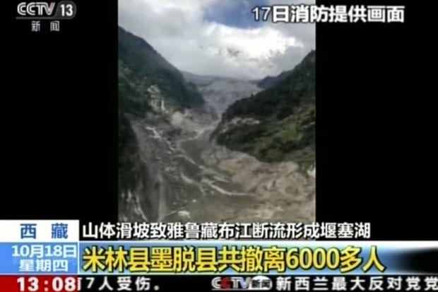
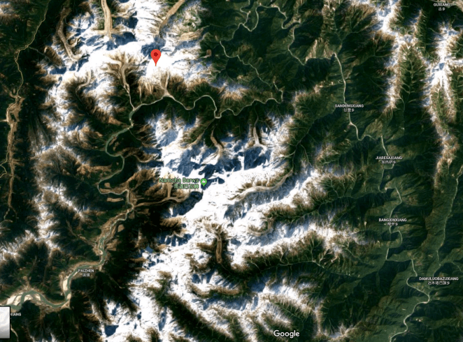
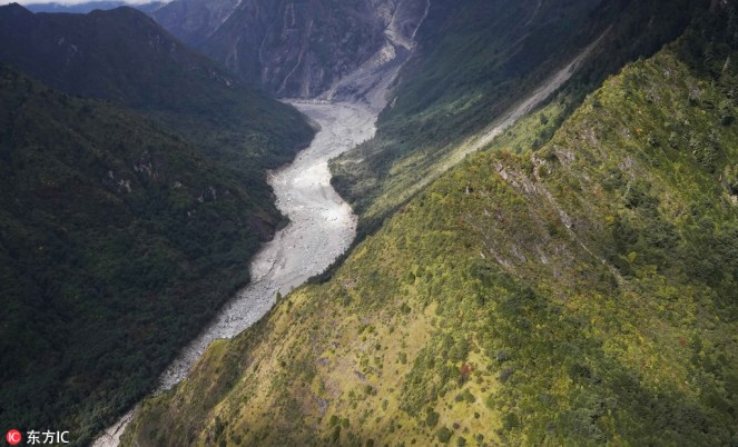
A massive dam, created by landslide in early hours (around 5 am) of Oct 17,2018 has blocked the main stream of Yarlung Tsangpo in Tibet. The reservoir behind the dam already has humungous 360 Million Cubic Meters (MCM) of water by 7 am on Oct 18, 2018 and as per latest reports (subsequently saw the CWC tweet put out at 955 pm on Oct 18, saying that storage had reached 484 MCM by 8 pm on Oct 18), the reservoir is still growing in size. The exact location of the landslide dam is uncertain. According to one source, the latitude longitude could be 94.93754° E, 29.74957° N, but this may not be accurate the likely location may be a few kilometers downstream from here. The Chinese media[i] has reported that the landslide dam is located at near Gyalha village in Milin or Manling county. According to some experts who visited the site, the dam could breach very soon, possibly on Oct 19, bringing massive floods along Siang river in Arunachal Pradesh.
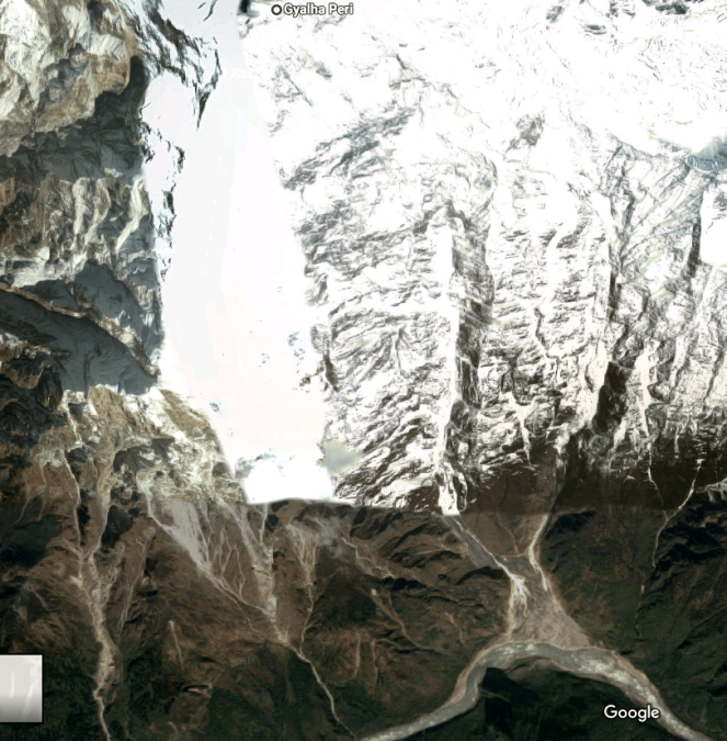
Available details about the Landlside dam The water level behind the landslide dam had risen 59 meters above the normal level by Oct 19 morning and was still rising by about 1 m per hour. The landslide originated from left bank of the river and is located The landslide body is located about 70 kilometers downstream from the nearest hydrology station and about 175 kilometers upstream from Medog County. A researcher who alerted India about the landslides along Yarlung Tsagpo in Dec 2017[ii] said that the Sendapu glacier surged and wasted between September & October 13th, releasing debris that possibly led to the landslide.
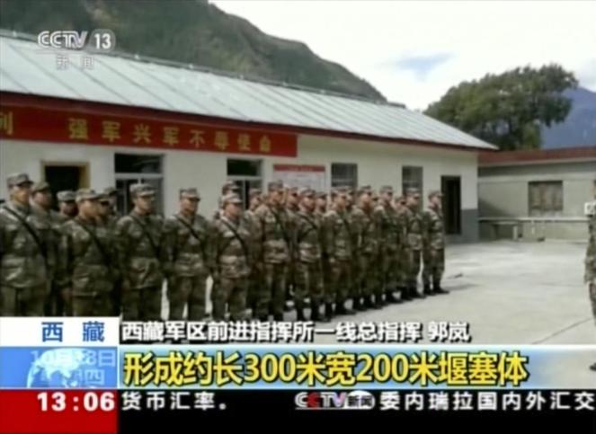
This Video from CCTV, China, taken on Oct 20, is very useful.
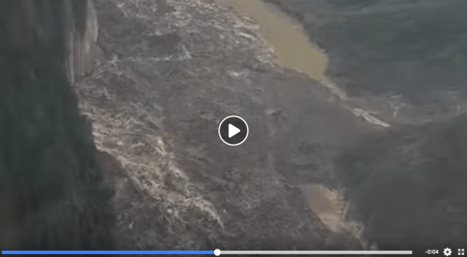
Here is another detailed video of the landslide reservoir and dam.
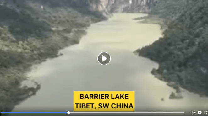
Small video clip of FB account showing landslide barrier and lake behind it
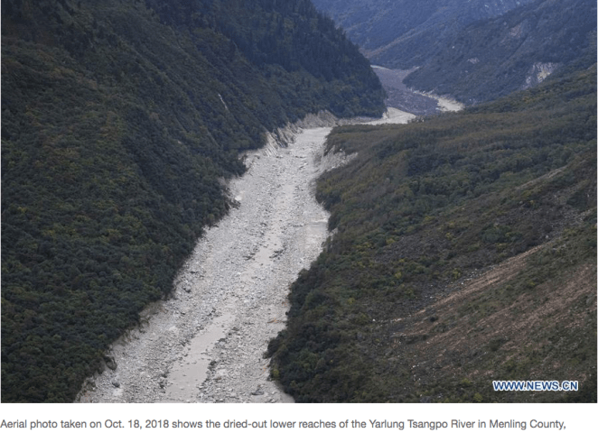
As of 12 noon on the 17th Oct, the reservoir behind the landslide dam was 15 kilometers long, the water level rose 40 meters above normal. The storage capacity had reached 150 MCM by 1500 hours on Oct 17[iii]. After the formation of the barrier lake, the water level and flow rate of the Dexing hydrological station in Medog County on the lower reaches of the Yarlung Zangbo River dropped from 74.28 m at 2000 hrs on the 16th Oct, to 73 m at 0800 hrs on the 17th and further to71.27m at 1400 hours on 17th Oct. The flow rate dropped from 3430 to 2620 cubic meters per second by 0800 hours and to 1580 cumecs by 1400 hrs on Oct 17[iv].
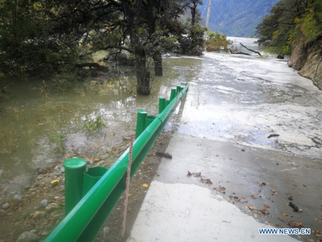
China Daily reported that 6000 people have already been evacuated and “More than 20,000 people in Manling and Medog counties were affected by the barrier lake and more people will be evacuated due to the risk of the barrier lake bursting.”
Notice from East Siang DM While China has already evacuated some 6000 people using military, including helicopters, its not clear to what extent Indian authorities are prepared to face this disaster. Unlike the June 11, 2000 episode when China failed to inform, leading to sudden floods creating much larger disaster, this time, as per the notice issued on Oct 18, 2018, the Chinese authorities have informed India. The notice from the collector of East Siang district warned, “general public is hereby cautioned from venturing into Siang River or its periphery for collection of firewood, fishing, swimming, bathing, etc, to avoid any eventuality and also people living in low lying areas (both the Right Bank and Left Bank areas of Siang River) viz. JARKU, PAGLEK, SS MISSION, JARKONG, BANSKOTA, BERUNG, JAMPANI, SIGAR, RALLING, BORGULI, SERAM, KONGKUL, NAMSING, MER, GADUM, to remain alert”. Beyond this notice, its not clear what other preparedness is in place to face the floods.
The notice acknowledged that the water level at Upper Siang, Yingkiong has already gone down by about 1.3 m compared to the level at 9 am on Oct 17.
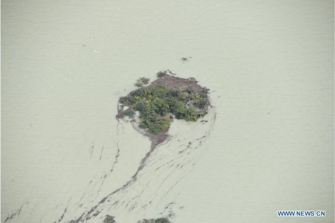
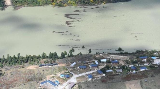
![The barrier lake formed by a landslide in the Yarlung Zangbo River in Southwest China's Tibet autonomous region on Oct 18. [Photo:IC]](https://sandrp.in/wp-content/uploads/2018/10/the-barrier-lake-formed-by-a-landslide-in-the-yarlung-zangbo-river-in-southwest-chinas-tibet-autonomous-region-on-oct-18-photoic.jpeg?w=663)
One Chinese report said: “Authorities in Tibet have launched an emergency response, calling for the safe evacuation of local residents. A work team has arrived at the site.”[v]
![The barrier lake formed by a landslide in the Yarlung Zangbo River in Southwest China's Tibet autonomous region on Oct 18. [Photo:IC]2](https://sandrp.in/wp-content/uploads/2018/10/the-barrier-lake-formed-by-a-landslide-in-the-yarlung-zangbo-river-in-southwest-chinas-tibet-autonomous-region-on-oct-18-photoic2.jpeg?w=663)
Another report (at 15:48 hrs on Oct 18) said: “The amounts of water in the lake has surpassed 300 million cubic meters. No casualties have been reported. Authorities in Tibet have launched an emergency response, monitoring the lake’s water level, evacuating local residents and sending relief supplies to the disaster-hit areas.”[vi]
![The barrier lake formed by a landslide in the Yarlung Zangbo River in Southwest China's Tibet autonomous region on Oct 18. [Photo:IC]3](https://sandrp.in/wp-content/uploads/2018/10/the-barrier-lake-formed-by-a-landslide-in-the-yarlung-zangbo-river-in-southwest-chinas-tibet-autonomous-region-on-oct-18-photoic3.jpeg?w=663)
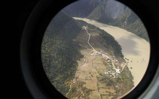
A brief aerial video of the site is available on Facebook[vii].
No information on Disaster Management sites No updates or early warning bulletins were available on ISRO or BHUVAN[viii] or Arunchal Pradesh State Remote Sensing Application Centre[ix] or National Disaster Management Authority or its Arunachal Pradesh specific[x] or Central Water Commission[xi] or its Flood Forecasting[xii] websites.
SANDRP (ht.sandrp@gmail.com)
POST SCRIPT: Some updates just (5.30 PM on Oct 19) received from reliable sources: 1. A video conference between New Delhi, Beijing and Arunachal Pradesh was held today. 2. The Breach of the dam HAS STARTED. 3. The size of the breached dam (360-400 MCM, could be a bit higher) is lower than the June 2000 breach which had reservoir of about 3000 MCM. 4. Left bank of Pasighat could be vulnerable.
2. Secretary, Disaster Management, Arunachal Pradesh issued a MOST URGENT letter in the afternoon of Oct 19, 2018 to Deputy Commissioners of East Siang, West Siang, Siang and Upper Siang district, mentioning a Video Conference taken by Union Cabinet Secretary with India’s ambassador to China. The letter mentioned that water started overflowing over the Landslide dam at 2 pm (IST) on Oct 19, at the rate of 18000 Cumecs (this seems rather high), saying that this is only overflow and “NOT ANY BREACH OF THE BLOCKAGE”, which is expected to reach Tuting 10-14 hours post overflow and another 8-10 hours thereafter, when water level would SUDDENLY rise. [Strangely, the letter does not provide specific latitude longitudes of the blockage.] The letter says special attention needs to be given to riverside villages in Mebo sub division which were badly affected by recent floods. It mentions deployment of 8 NDRF companies on 20th Oct 2018.
3. At 9.19 pm on Oct 19 CWC tweeted: “The outflow from blockade in China on Yarlung Tsangpo river increased rapidly to 14,800 cumec at around 1930 hrs IST (2200 hrs Local Chinese Time) in temporary measuring point downstream of Landslide Dam.” This indicates that the figure of 18000 cumecs mentioned in the notice of Secretary, DMA was tentative.
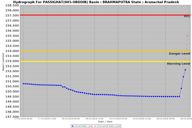
4. CWC flood forecasting station says right now (10.20 am, Oct 20) that Siang River water level at Pasighat at 10 am was 152.13 m, and is likely to jump to 155.5 m (HFL here is 157.54 reached on 11 June, 2000 when the previous landslide triggered floods were experienced at Pasighat), see the CWC flood hydrograph below.
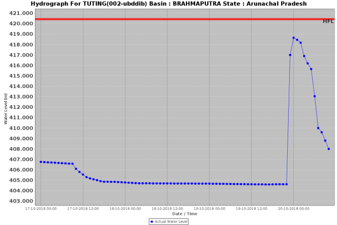
At upstream site Tuting on Siang, the water level has passed the peak at 1200 midnight on Oct 19. (HFL here is 420.43 m, reached on 06-09-2010, water level last night was close to 419 m, about 1.6 m from HFL.)
5. At 10.49 pm (Oct 19) CWC Tweeted: “The Chinese Ministry of Water Resources has informed that the temporary station downstream of land slide dam has been flooded and they are unable to collect water level. The original message is appended.”
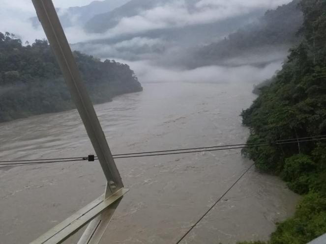
6. CWC on FB has posted photos of Siang River at Yingkiyong (downstream from Tuting) on Oct 20, morning, see:https://t.co/noZm3qvyjk
~~~~~~~~~~~~~~~~~~~~~~~~~~~~~~~~~~~~~~~~~~~~~~~~~~~~~~~~~~~~~~~~~~~~~~~~~~~
7. The landslide dam was totally emptied by overflow and breach of the same by Oct 20 from all indications.
END NOTES:
[i] http://www.chinadaily.com.cn/a/201810/19/WS5bc928e8a310eff30328344e.html
[ii] https://sandrp.in/2017/12/24/muddy-siang-is-sign-of-danger-ahead-wake-up-call-for-indian-authorities/
[iii] http://www.xinhuanet.com/politics/2018-10/17/c_1123573907.htm
[iv] http://www.sohu.com/a/260048898_114988
[v] http://www.xinhuanet.com/english/2018-10/17/c_137539676.htm
[vi] http://www.xinhuanet.com/english/2018-10/18/c_137541636.htm
[vii] https://www.facebook.com/XinhuaNewsAgency/videos/321632905282893/
[viii] http://bhuvan-noeda.nrsc.gov.in/disaster/disaster/disaster.php#
[ix] http://ardst.arunachal.gov.in/state-remote-sensoring-application-center/

Yes, I have added a line (point 7) in post script. In fact there was second landslide dam at the same location (see: https://sandrp.in/2018/11/01/another-landslide-dam-on-yarlung-tsangpo-raises-more-questions/) starting Oct 29, 2018, which too got breached as mentioned in second blog.
LikeLike