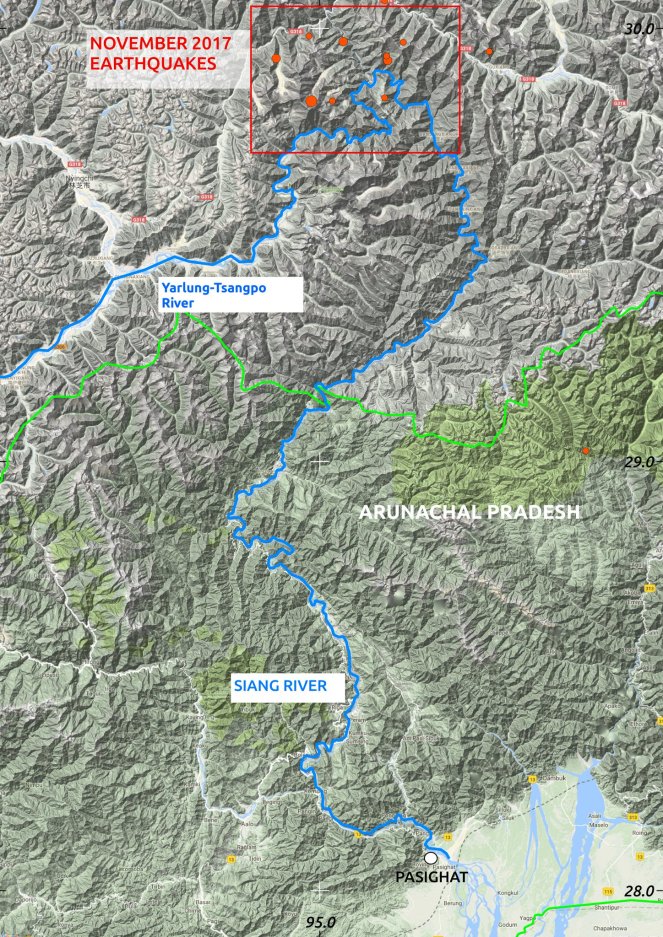
The current ongoing episode of Muddy Siang River water in Arunachal Pradesh is due to landslides in the upstream Tibet, triggered by the earthquakes starting on Nov 17, 2017 or possibly earlier. This is revealed by the satellite pictures and work of two researchers, first published in Arunachal Times on Dec 21, 2017[i]. These landslides are partly blocking the Siang flow and could lead to massive floods in the downstream Arunachal Pradesh and Assam any day.
A similar event in year 2000 led to sudden, massive floods in Siang River in Arunachal Pradesh on June 1, 2000. That episode, like the current one, started about 53 days before the floods, on April 9, 2000 due to landslides along a tributary of Yarlung Tsangpo, as Siang is known in Tibet.
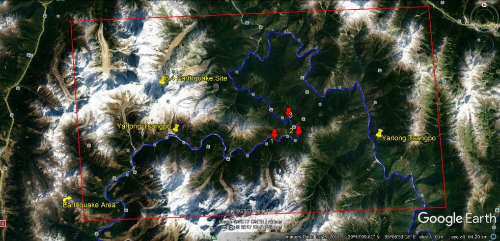
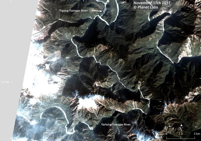
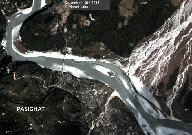
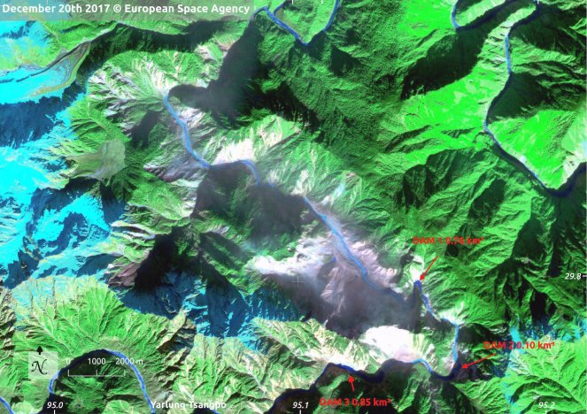
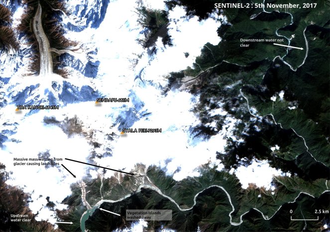
In current episode, as per Chintan Sheth and and Anirban Datta-Roy, three landslides are partly blocking the main stem pf Yarlung Tsangpo, in the Bayi district, Nyingchi County in Tibet. They are spread over 6 km length of the Yarlung Tsangpo, just upstream of the famous U-turn that the river takes before entering India. The landslides with total volume of about 1 BCM (Billion Cubic Meters), as estimated by the Sheth et al from the latest available satellite pictures of Dec 20, 2017, are upstream of the confluence of Yigong, a major tributary of Tsangpo, the authors write: “This landslide is 400 km upstream from Pasighat and 200 km from Geling.”
Satellite Map of Earthquake location hours before the Nov 17, 2017 earthquake (Source: Sheth et al, https://twitter.com/tweetweetforest/status/944033795711254528)
Earthquakes that triggered the landslide While the 6.4 magnitude earthquake on Nov 17 seems to be trigger for the landslides, strangely, India Meteorology Department, that monitors the earthquakes that affect India, has no information about this earthquake on its website[ii].
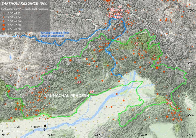
I found detailed information about these earthquake on the USGS Earthquake site[iii], which is tabulated below.
| Magnitude | Location in China | Depth, km | Date and Time (UTC) | Latitude | Longitude |
| M 6.4 | 63km ENE of Nyingchi | 8 | 2017-11-17 22:34:19 | 29.833°N | 94.978°E |
| M 5.1 | 63km NE of Nyingchi | 10 | 2017-11-18 00:32:01 | 29.931°N | 94.884°E |
| M 4.1 | 61km WNW of Zhamog | 10 | 2017-11-18 02:13:40 | 30.063°N | 95.172°E |
| M 4.2 | 53km WNW of Zhamog | 10 | 2017-11-18 03:36:06 | 29.968°N | 95.221°E |
| M 4.2 | 73km NE of Nyingchi | 26.7 | 2017-11-18 05:59:47 | 29.982°N | 94.971°E |
| M 4.4 | 63km NNW of Motuo | 10 | 2017-11-18 21:24:49 | 29.833°N | 95.033°E |
| M 4.1 | 31km WNW of Zhamog | 10 | 2017-11-19 08:52:24 | 29.947°N | 95.449°E |
| M 4.4 | 55km W of Zhamog | 26.4 | 2017-11-23 02:14:17 | 29.840°N | 95.172°E |
| M 4.7 | 56km W of Zhamog | 10 | 2017-11-23 07:13:47 | 29.926°N | 95.180°E |
IMD earthquake site: http://www.imd.gov.in/pages/earthquake_prelim.php
Lists two earthquakes post Nov 17: 1. On Nov 17, 2017 11.50 (IST): 4.2: Dhemaji region
- Nov 21: 00.17, 3.9, W Kameng, Arunachal Pradesh. They do not even list the quakes that may not have been felt within India, even though they may affect India in a major way, the way the Tibet earthquakes listed above do.
River not completely blocked? One possible good news is that there are as yet no reports of Siang river flow stopping due to the landslides, which means that water flow may have reduced and it may be accumulating, but it does not seem to have been completely blocked by the landslides. However, that conclusion may need to be confirmed with additional satellite images, since water could also be coming from Yigong and other tributaries meeting Tsangpo downstream of landslide sites.
There are a few unanswered questions from what Sheth et al have postulated through their Arunachal Times article and tweeter feed[iv]:
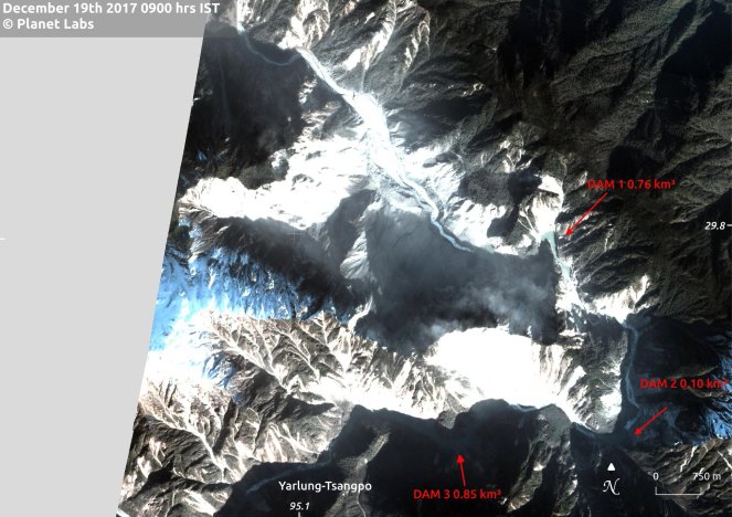
– The estimated size of three landslide dam along Yarlung Tsangpo are given as 0.85 BCM, 0.1 BCM and 0.76 BCM, totaling 1.71 BCM, more than 1 BCM given in the text of the article. The three dams are a couple of kms from each others, so is this fear expressed by Sheth et al realistic: “…it is too early to rule out the possibility of these three dams from merging and becoming larger”?
– There is no news of complete stoppage of water in Siang due to blocking of the water flow of Siang by the dams on the main stem. However, there could be reduction in flow of water due to these dams and water could also come from Yigong and other tributaries meeting Tsangpo downstream from landslide dam locations. However, we need to know if the size of the dams on Tsangpo is still increasing? When exactly were the dams formed and if over 1.5 BCM water has already accumulated behind these dams, when that happened?
– The fact that muddy water has been flowing constantly since over a month means that the Tsangpo waters were never completely blocked?
– Sheth et al also suggest, based on satellite images, that between 11th and 27th Oct, a landslide occurred several kilometers upstream the current location of the earthquake-induced-landslides. Do we know what triggered this landslide?
Why China does not inform India about such natural events? The Chinese authorities failed to inform India about the massive landslide dam, along Yigong River in April-May 2000 for over 50 days, it led to the biggest outburst from a landslide-dammed lake ever documented in modern history. A Chinese expert recetwntly confessed in a meeting where this author was present that China was preparing to breach that landslide and hoped to convey to India and Bangladesh, the downstream countries, as soon as that plan was firm, but before they could firm up the plan, the 90 m deep reservoir behind the landslide dam overflowed and breached the landslide, leading to massive, sudden floods in India, taking the people completely unaware and thus increasing the proportions of the damage. Years after that episode, Indian minister told the Parliament that India has no clue what created that flood.
The history is repeating, with no official information from China as yet about the latest landslides along Tsangpo, over a month after the landslides seem to have happened. Media reports suggest that when Indian Foreign Minister Sushma Swaraj met her Chinese counterpart Wang YI in Delhi on Dec 11, 2017 on the sidelines of Russia-India-China meeting, this issue was taken up, as pre some media reports.[v]
Why this silence from Indian government? However, the biggest question that arises from the whole episode is that why are Indian authorities completely silent, quite about the whole episode that clearly creates huge risks for the people of Arunachal Pradesh. It has already created huge impact in polluting the Siang and downstream Brahmaputra water, killed fish and with it livelihood of thousands, if not lakhs and the impacts are still unfolding.
As I write this, India’s elaborate disaster management institutions seems completely silent about this unfolding disaster, including: National Disaster Management site: http://www.ndmindia.nic.in/, National Institute of Disaster Management: http://nidm.gov.in/default.asp, National Disaster Management Authority: http://www.ndma.gov.in/en/, NDRF: http://www.ndrf.gov.in/. The Space Application Centre and ISRO that provide satellite images during disasters, also have nothing to report. Arunachal Pradesh do not seem to have active State Disaster Management Authority.
On Dec 14, 2017, media reported[vi], “The external affairs ministry has taken up the matter of the Brahmaputra’s turbidity with China for a “pragmatic and exhaustive” study to find out the real cause following widespread concern in the Northeast. External affairs minister Sushma Swaraj said this in a meeting at Prime Minister Narendra Modi’s residence in Delhi on Tuesday evening (Dec 12, 2017) after Assam chief minister Sarbananda Sonowal urged the Centre to take up the issue. During the meeting, Union home minister Rajnath Singh, finance minister Arun Jaitley, minister of road transport, water resources and river development Nitin Gadkari and Swaraj discussed the matter and the steps taken so far.”
There is no information in public domain as yet, what action was taken by this high level meeting at PM’s residence in the evening of Dec 12, 2017. The least one expected was that satellite maps would be procured, analysed and a disaster management strategy put in place, but there is no sign of that in public domain.
Central Water Commission The Central Water Commission, India’s premier technical body on water resources and that was expected to provide the necessary inputs in guidance on such occasions, seems to have drawn a blank so far. Its website[vii] has no information about this event.
As early as on Dec 3, 2017, there were reports[viii] about Union Minister saying that they are expecting CWC to provide the insight into muddy Brhamaputra waters: “A preliminary study has found that the water of the Siang river, which originates in southern Tibet and becomes the Brahmaputra upon entering Assam through Arunachal Pradesh, is turning black due to a recent earthquake in the region, Union minister Arjun Ram Meghwal has said. “We have been getting reports of pollution in the river and its water turning black. The Central Water Commission (CWC) has started looking into the matter recently and people have been sent to the internal areas,” the Union minister of state for water resources said in New Delhi on Sunday (Dec 3, 2017).”
In Media reports on Dec 15, 2017[ix], it has just this to offer: “But, it (CWC) has no conclusive reason why Siang has turned black due to cement-like slag, which has been flowing from across the McMohan line for over a month now… We are yet to ascertain why the Siang turned black. The reasons have to be found inside Chinese territory.”
Even in Media reports on Dec 22, 2017,[x] one of the highest official of CWC, Pradeep Kumar, Member (River Management), was quoted saying: “However, landslide-induced turbidity usually subsides within a week. So we are examining the situation through satellite images as the affected area is not within our territory. We will get a clearer picture soon.”
In fact, Kumar said, “We monitor all natural lakes in the region. China shares river data with us. We have already sought help from the National Remote Sensing Centre and will do whatever is necessary when we have a clearer picture.” Unfortunately, there is no evidence of CWC monitoring these landslide dams and even on Dec 21, he was telling that we have sought help from NRSC, for landslide dams that formed possibly a month earlier.
In Conclusion Over five weeks after the event of earthquake and after over three weeks after Union Minister saying publicly that they are expecting CWC to provide necessary insights and guidance and after 12 days after a meeting of senior ministers at PM’s residence, the nation is still waiting for CWC to provide first ray of help in this matter. This when people of Assam and Aruachal Pradesh are already suffering and could be in store for a bigger disaster any day.
The least one can expect Indian authority is to follow this advise of Sheth et al: “A panel of remote sensing experts, geologists, hydrologists and disaster management experts need to be set into action right away for the safety and economy of the people. It is also critical for the people of Arunachal to scientifically study the geography and ecology of the region not only prepare for disasters but to develop sustainably.”
SANDRP (ht.sandrp@gmail.com)
PS: Two earthquakes struck the same region on Dec 20, 2017:
1. http://eng.tibet.cn/news/th/1513733893569.shtml
5.0-magnitude quake hits Tibet: CENC
A 5.0-magnitude earthquake jolted Bayi District of Nyingchi City, southwest China’s Tibet Autonomous Region at 1:40 a.m. on Wednesday, according to the China Earthquake Networks Center (CENC).
The epicenter was monitored at 29.88 degrees north latitude and 95.08 degrees east longitude. The quake hit at a depth of 6 kilometers, according to the CENC.
2. http://www.ecns.cn/2017/11-18/281428.shtml
6.9-magnitude earthquake hit Tibet
2017-11-18 10:56XinhuaEditor: Feng Shuang

No casualty has been reported after a 6.9-magnitude earthquake hit Nyingchi, southwest China’s Tibet Autonomous Region at 6:34 a.m. Saturday Beijing Time, according to the China Earthquake Networks Center (CENC). However, the quake caused power failure and building damages in a number of villages in the epicenter in Nyingchi City.
The epicenter was monitored at 29.75 degrees north latitude and 95.02 degrees east longitude. The quake struck at a depth of about 10 km. Several minor aftershocks were felt. Basang Cering, Party chief in Zhaxigang Village of Lunang Township, told Xinhua that he can not stand still in his house when the quake struck. Six houses in his village had damages from the jolt.
Meanwhile, Dainik Jagran Hindi Newspaper report dated December 27, 2017 confirms 3 landslide dams on Yarlung Tsangpo following earthquakes in Tibbet area. Meeting between National Security Advisor Ajit Dobhal and State Councillor Yang Jeichi on Dec, 22, 2017 on the issue also reported. http://epaper.jagran.com/ePaperArticle/27-dec-2017-edition-Delhi-City-page_17-6409-4978-4.html
Similarly NDTV December 2017 report, quotes Chinese Foreign Ministry spokesperson Hua Chunying saying that a 6.9-magnitude earthquake in mid-November near Mainling County in Tibet, as a cause behind turbidity in river water.
On formation of landslide dams she said “We have noted that Indian media recently made a series of reports on this issue. They said China was conducting water conservancy project or exploiting a mine previously whereas now claim there is a barrier lake upstream.
“After the earthquake, we monitored the water quality of the Yarlung Zangbo (Chinese name for Brahmaputra) River and the results showed that it met the standards of Class III water,” she said.
As per the spokesperson China will maintain communication with India to deal with massive lakes formed by landslides on the Brahmaputra river in Tibet following the earthquake, which caused concerns of a sudden flooding on the Indian side.
She said verification by the relevant Chinese authorities revealed that the lake is to the “eastern section of the India-China boundary”. https://www.ndtv.com/india-news/china-says-earthquake-in-tibet-behind-brahmaputras-turbidity-1792830
3. https://arunachaltimes.in/index.php/2017/12/27/earthquakes-most-probable-cause-of-siang-turning-muddy-study/
Earthquakes most probable cause of Siang turning muddy: Study
A team of scientists and engineers of the SRSAC conducted the study, using the satellite data of dates before and after the Siang turning muddy. The team collected water samples from different locations of the Siang during 8 to 10 December and the sample had been sent for laboratory analysis.
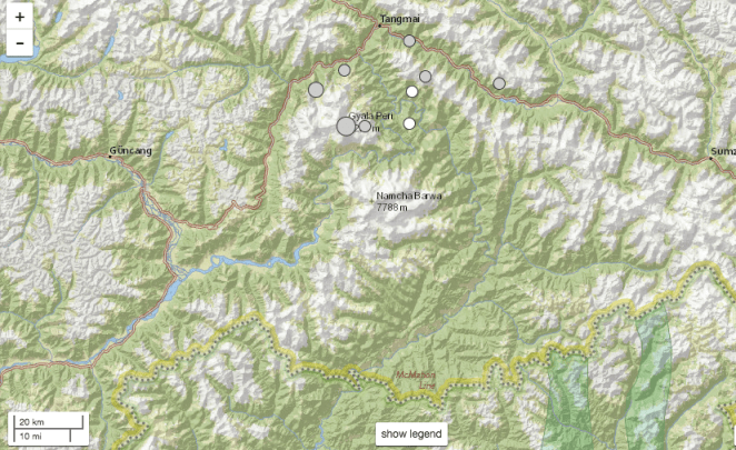
The SRSAC informed that nine earthquakes of magnitudes ranging from 4.1 to 6.4 were recorded in and around Namcha Barwa area of Tibet region from 17 November to 23 November.
‘Considering the fact that there may be a connection of muddy water flow in the Siang with the recent earthquakes, a preliminary temporal remote sensing study was carried out with pre- and post-earthquake satellite data.
‘As per post-earthquake satellite data, it is found that at the location of longitude 95° 09′ 07”E and latitude 29° 47′ 41”N, which falls in Namcha Barwa area of Tibet (China), the colour of water of the Siang has changed from blue to grey. Whereas, in pre-earthquake satellite data, the entire course of Siang River is found to be blue and no such kind of changes has been observed,’ the SRSAC said.
‘In-post earthquake satellite data, where change in colour of Siang is found, many patches of barren areas with greyish white signature are observed in the surrounding steep hill slopes, while in the pre-earthquake satellite data, red signature in the same patch are seen indicating presence of vegetation and found undisturbed,’ it said
The SRSAC also said many more landslides may have occurred in the area during this period which could not be delineated due to cloud cover in the post earthquake satellite image.
‘The change of turbidity of the Siang river water may be due to the huge debris fallen in the course of river because of these landslides. However, there is scope of a detailed study using high resolution cloud free satellite data,’ it added.
Over the last few weeks, there has been a growing concern over the cause of the Siang river’s water turning muddy, becoming unfit for drinking, and posing a threat to aquatic life in the Siang and the Brahmaputra.
China to maintain communication with India on artificial lakes due to flooding concerns
As per reports, three huge artificial lakes, whose size and volume of water in them are yet to be estimated, were formed in the Brahmaputra river, known locally as the Yarlung Tsangpo, due to landslide after a 6.4-magnitude earthquake in Tibet last month.
By: Express Web Desk | Beijing | Updated: December 26, 2017
China has agreed to maintain constant communication with India to deal with massive lakes that form due to landslides on the Brahmaputra river in Tibet following an earthquake, which caused concerns of a sudden flooding on the Indian side, a Foreign Ministry official was quoted as saying by PTI. As per reports, three huge artificial lakes, whose size and volume of water in them are yet to be estimated, were formed in the Brahmaputra river, known locally as the Yarlung Tsangpo, due to landslide after a 6.4-magnitude earthquake in Tibet last month.
The cause of worry is this: In the event of the lakes joining or bursting, it could potentially endanger the lives of millions of people residing along the banks of both Siang (in Arunachal Pradesh) and Brahmaputra (in Assam) downstream. “The Chinese side, through the existing channels, will maintain communication with the Indian side on the cross-border rivers,” Chinese Foreign Ministry spokesperson Hua Chunying was quoted by PTI as saying. She added that the verification by the Chinese authorities has revealed that lakes are on the eastern section of the India-China boundary.
“It is caused by natural factors. It is not a man-made accident. I noticed that authorised Indian professionals have made an analysis and clarified,” Hua said, referring to reports of the lakes being detected by satellites. She also cautioned that Indian media should avoid any speculation over the issue. “We hope the Indian media will not make a groundless speculation on this,” Hua said, adding that the Chinese officials concerned will maintain communication with the Indian side on the issue.
China had earlier refuted reports that the highly-polluted water in the Siang river was caused by attempts to build a massive tunnel to divert the water to neighbouring arid Xinjiang region. The issue was reportedly discussed during the recent 20th border talks between NSA Ajit Doval and Chinese State Councillor, Yang Jiechi on December 22 in Delhi.
5. Assam’s Finance Minister sees China hand in Muddy Siang waters: https://timesofindia.indiatimes.com/city/guwahati/chinas-hand-in-brahmaputra-pollution-irrefutable-himanta-biswa-sarma/articleshow/62276866.cms
On Tuesday, a Chinese foreign ministry spokesperson Hua Chunying had said China would “maintain communication with the Indian side on the cross-border rivers” after reports of the formation of three artificial lakes because of landslides in the upper reaches of the Brahmaputra had surfaced.
Sarma, considering the statement as a tacit admission of China’s role in the pollution of the river, said, “China has accepted that the pollution of Brahmaputra was from the Chinese side. The government of India needs to examine the Chinese statement carefully before giving its reaction. According to information available with us, the Centre recently procured data on the pollution of the Brahmaputra through remote sensing.”
Sarma has, time and again, expressed certainty that China has a role to play in the waters of the Siang, the principal constituent of the Brahmaputra, turning turbid.
Earlier this month, he said dam building exercises by China could be the reason the waters were turning dark. Urging the Centre to go through the official statement of the Chinese government, Sarma said it needs to assess how the matter affects the people of the northeast.
6. http://www.asianage.com/india/all-india/010118/artificial-lakes-in-mystical-beyul-pemako-still-growing.html
This report mentions some additional information about the Siang landslides: “The area of the prime mountain slide zone is measured to be approximately 78 sq km as extracted from the satellite imagery. This slide zone is relatively close to eastern Tibet major tourist city of Nyingchi at a distance of 139 km downstream.” “From an inspection of multi-date satellite images of the affected zone, it could be inferred that the landslide process resulting in debris dam growth is yet to reach its final equilibrium stable state. This is a worrisome occurrence, especially pertaining to potential debris dam breach flood in coming days or months with serious portents for downstream habitation areas in eastern Tibet, Arunachal Pradesh and Assam”, he said adding that the major mountain slide zone extends over a river length of about 33 km which is located about 47 km away from the commencement of Yarlung Tsangpo Grand Canyon.
7. GDACS (Global Disaster Alert and Coordination System) update about Nov 17 earthquake: http://www.gdacs.org/report.aspx?eventtype=EQ&eventid=1126722
8. David Petley Blog dated Jan 2, 2018 on this event: https://blogs.agu.org/landslideblog/2018/01/02/yarlung-tsangpo-1/
END NOTES:
[i] https://arunachaltimes.in/index.php/2017/12/21/earthquakes-in-tibet-have-triggered-massive-landslides-darkening-the-siang-river/
[ii] http://www.imd.gov.in/pages/earthquake_prelim.php
[iii] https://earthquake.usgs.gov/earthquakes/, goo.gl/pb1Tr5
[iv] https://twitter.com/tweetweetforest
[v] https://economictimes.indiatimes.com/news/politics-and-nation/sushma-swaraj-chinese-foreign-minister-discussed-siang-river-issue/articleshow/62071214.cms (Dec 14, 2017)
[vi] https://www.telegraphindia.com/states/north-east/river-turbidity-raised-with-china-sushma-193345
[viii] http://www.hindustantimes.com/india-news/brahmaputra-water-could-be-turning-black-due-to-recent-quake-minister/story-32rlMHlb42lHSt1NdOV4gL.html
[ix] https://timesofindia.indiatimes.com/india/no-evidence-of-china-diverting-water-of-siang-cwc/articleshow/62088735.cms
[x] http://indianexpress.com/article/india/whats-darkening-brahmaputra-landslide-not-chinese-machines-4993783/
