About Odisha
Odisha is located on the eastern coast of India, between 17o31‟ and 22o 31‟ N latitude and 81o 31‟ and 87 o 31‟ E longitude. It covers 155,707 km2 , which represents about 4.74% of the area of India. The climate of state is tropical with 1450mm average rainfall.
The 2011 Census established the State‟s population at 41.9 million, 16% of which lived in urban centres. The average population density is 270 persons per km2, compared to 382 for India. Odisha is a land of possibilities. The State is endowed with bountiful of resources, people, land, water, forest, minerals and other minor resources. The State is divided into 30 districts, of which Mayurbhanj is the largest (1042km2) and Jagatsinghpur the smallest (197km2). The districts are subdivided into 314 CD Blocks. There are 58 sub-divisions and 171 tahasils. According to 2001 census there are 51,349 villages and 6234 Gram Panchayats.(ORISSA STATE WATER PLAN, 2004).
About Odisha Water Resources
Surface Water :-Water resources of the State are derived from the annual rainfall in the State. The State receives 230.76 BCM of rainfall in a normal year. Water availability in the State on a 75% dependable basis works out to 95.54 BCM now, which will reduce to 85.89 BCM in future.
Groundwater :- According to the latest assessment, Odisha has annually replenishable ground water resource of 21 BCM (ham), out of which 12 BCM is taken as safe for use. Thus, Average surface and ground water potential of the State is 141 BCM at present which is estimated to reduce to 129 BCM in 2050. (ORISSA STATE WATER PLAN, 2004)
Forest Area:- The State has a total forest area of 58,135 km2, which is about 37% of its geographical area. The Department of Forest and Environment manages 26,350 km2 of Reserve forests area (RFs) under various working plans and schemes while 31,786 km2 are Demarcated Protected Forests (DPFs) and Undemarcated Protected Forests (UDPFs) and other forests.
About Odisha Rivers
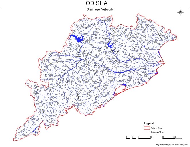
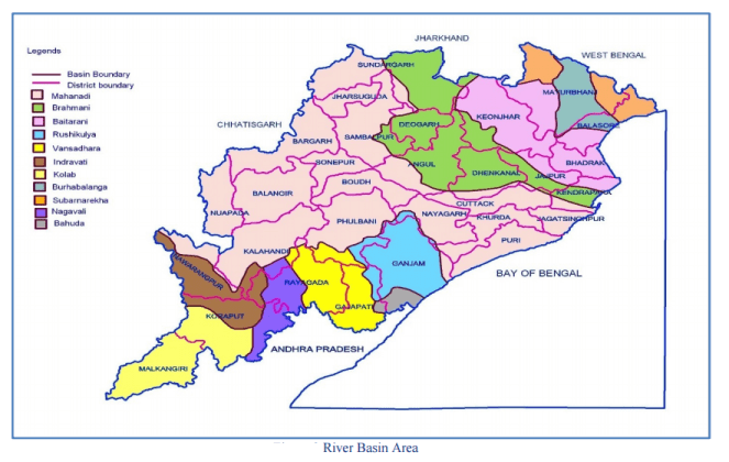
Odisha is drained by 11 major rivers and their tributaries, which are clearly separated by high ridges. The north of Mayurbhanj district is drained by Subarnarekha where as the south of the district and parts of Balasore district is drained by Budhabalang River. Districts of Kendujhar and Bhadrak drain into Baitarani. Sundargarh, Debgarh, Angul, Dhenkanal, Jajpur and Kendrapara drain into Brahmani river.Part of Sundargarh, Jharsuguda Sambalpur, Baragarh, Sonepur, Balangir, Nuapara, Cuttack, Jagatsinghpur, Khurda and Puri drain into Mahanadi. Kolab and Indravati drain Nabarangpur, Malkangiri and Koraput districts and Vansadhara and Nagavali drain Rayagara and parts of Gajpati districts. Ganjam is drained by Rushikulya River. In the upper reach of the rivers the slope is steep and there is no problem of drainage. But once the rivers reach the coastal plains the slope flattens and velocity reduces and drainage congestion occurs. (ORISSA STATE WATER PLAN, 2004).
Status of Odisha River

- Mahanadi [Tributaries inside Odisha are Ib (Industrial and coal mining pollution), Bheden (Industrial pollution) Ong, Tel, Jira, Bagh, Salki, Kuanria, Hariharjore, Sagada, Ret, Hati, Indra, Suktel, Utei, Remal, Udanti, Lanth, Sapua]. Mahanadi is RED because 250 km stretch of the river out 494 Km inside Odisha, is highly polluted. Pattern of precipitation in the Mahanadi catchment is changing, Water resources development by the upper riparian state Chhattisgarh has the potential of reducing the base flow of the river threatening the ecology in the deltaic area, Satkosia wildlife sanctuary, Chillika, and to some extent Bhitarkanika biosphere reserve. Dams and barrages developed and proposed by Chhattisgarh, and Odisha and the proposed link of Mahanadi – Godavari are the new threats to the delta. Non-occurrence of flood in the parts of the delta and heavy nutrient load due to urban centers like Bhubaneswar has started clogging the distributaries. Agriculture and Industry conflict is brewing fast in this basin.
- Distributaries- Kathajodi, Birupa, Kuakhai, Daya, Bhargavi, Kushabhadra, Biluakhai, Devi, Kandala, Chitrotpala, Luna, Karandia, Paika, Badagenguti] Mojor distributaries are RED because of release of urban sewer and garbage into river Mahanadi and Kathajodi at Cuttack, and to the other distributaries by Bhubaneswar, Jagatsinghpur, Paradeep etc. urban centers. Apart from industrial and sewer Mahanadi system is contaminated by bio medical waste from Cuttack and other urban centers, fertilizer and pesticide runoff from agricultural fields.
- Hirakud Resrvoir is PINK because of heavy siltation, power plants in the upstream of the reservoir, thermal power plants right on the bank of the reservoir which have ash ponds in the reservoir area. The threat to the functioning of the reservoir is enhanced due to water resources development in Chhattisgarh that has created the apprehension that the non-monsoon flow to the reservoir will be reduced).
- Chillika Lake (Water salinity is changing, urbanization in its catchment area that also includes Bhubaneswar, Kanasa, Brahmagiri, Ganjam, Balugaon etc. has contributed to its pollution. Increased nutrient load has given rise to eutrophication and growth of weeds in many parts of the lake. Opening of new mouths to the sea has started threatening its very existence.
- Brahmani[Sankha, Chandrinalla, Katangamundanalla, Rukura, Badjore, Kaunishnalla, Kalanalla, Usthalinalla , Chudakhainallah, Gohira, Chilanti, Tikira, Singadajore, Bangaru, Nandiranalla, Nigra, Bangusinghanalla, Barha, Daunri, Kumaria, Kelua, Birupa, Hansua, Kharsuan, Patasala, Koel, Champalijore, Kuradihi, Amrudi, Korapani, Mankada, Ambahari, Samakoi, Gambhiria, Raijore, Indrajeet, Ramiala, Pandra, Kharasuan, Daudi.
- Brahmai is RED because of largescale industrial and mining activities at Rourkela, Angul Talcher areas, KJalinganagar etc. Urban centers also contribute to the pollution. About 250 km stretch of the river out of 491 Km length inside Odisha, is D class water. Excessive withdrawal of water from the river also has reduced the downstream flow of the river. But the nature of flood in Brahmani is changing and it has become more threatening in the recent years.
- Baitarani [Budhi, Kanjori, Ambajhara, Mushal, Kusei, Salandi] 70 km stretch of Baitarani out of total 360 Km, is polluted from Jajpur-Kuakhia Road to Dhamara Baitarani river is threateeed (RED) because of largeschale mining in Keonjhar and Jajpur districts, deforestation. During the rainly season the water of the river is almost red with the washed out ironore mine dumps. Due to change in the land use, the flow of the river also has been on the decline. Water extraction for the transportation of iron ore fines and other industrial use has led to conflicting situation.
- Subarnarekha [Kharkai, Roro, Kanchi, Harmu Nadi, Damra, Karru, Chinguru, Karakari, Gurma, Garra, Singaduba, Kodia, Dulunga and Khaijori] Subarnarekha is PINK due to presence of Balasore town and adjoining industrial area.
- Rushikulya [Padma, Boringa nallah, Joro, Badanadi, Baghua, Dhanei, Kharkhari and Ghodhado] Rushikulya is very fast turning out to be a deficit basisn leading to water scarcity in the basisn area. Reduced flow coupled with industrial effluents and the run off from agricultural fields contributes to the pollution.
- Inderavati [Keshadhara Nalla, Kandabindha Nallah, Chandragiri Nalla, Golagar Nalla, Poragarh Nalla, Kapur Nallah, Muran River, Bangiri Nallah, Telengi Nallah, Parlijori Nallah, Turi Nallah, Chourijori Nallah, Damayanti Sayarh, Kora river, Modang river, Padrikundijori river, Jaura river & Bhaskel river]. Indravati may give rise to another interstate river conflict between Odisha and Chhattisgarh. The areas in the basin deprived of irrigation and restive and it may lead to difficult situations. Pollavaram project already is an area of conflict between the states of Odisha and Andhra Pradesh.
- Vamsadhara [Bhangi, Pedagoda, Badanalla, Chauladhua, Pandaka Nalla, Badajhar, Harbhangi, Sananadi, Mahendratanaya]. Out of 176 km of river, a stretch of 5 km stretch from Gunupur town to Bathili is polluted.
- Nagavalli [Pitadar Nallah, Datteibannda Nallah, Sananadi, Barha Nadi, Baldiya Nadi, Sat Nallha, Sitagura Nallha, Ghora Nalla, Sitaghera Nalla, Srikona Nadi, Bonamarha Nadi,Errigeda Nallha, Jhanjhabati river]
- Budhabalanga [Palapala, Sunei, Kalo, Sanjo, Deo, Gangahari and Katra] Budhabalanga river id PINK because of industrial and urban pollution.
- Bahuda [Poichandia, Bogiriadi, Batrada Nalla, Kantajura Nalla] Bhuda is RED because it is fast approaching to a deficit basin.
- Kolab [Karandi Nalla, Guradi Nalla, Kangar Nallah, Garia, Dharmageda Nallah, JamNadi, Malengar River, Mulervagu Nallah, Potteru Vagu Nallah, Machhakund, Sileru]
Ranking based on the Health of the Rivers of Odisha
|
River Basin Ranking |
Water stress |
Industrial use |
Length of the river polluted |
Pollution Based on the BoD (0 least polluted) | Cumulative Rank
(Scores of prev parameters added and ranked) |
| Mahanadi | 1 | 1 | 5 | 4 | 5 |
| Brahmani | 2 | 1 | 5 | 4 | 4 |
| Baitarani | 4 | 2 | 3 | 5 | 3 |
| Inderavati | 0 | 0 | 0 | 1 | 10 |
| Rushikulya | 5 | 3 | 2 | 5 | 1 |
| Vamsadhara | 1 | 0 | 1 | 5 | 6 |
| Nagavali | 1 | 0 | 1 | 3 | 9 |
| Budhabalanga | 3 | 1 | 1 | 2 | 7 |
| Subernarekha | 2 | 0 | 1 | 1 | 8 |
| Bahuda | 5 | 4 | 1 | 4 | 2 |
| Kolab | 0 | 0 | 0 | 1 | 10 |
Odisha Rivers Agreements & Conflicts


To come out with an overall statement on the health of the rivers the scores of the rivers have been added together and the rivers have been ranked. Rushikulya comes out as the most distressed river. It already is water scarce and also has a heavy pollution loan though in a relatively lesser stretch. Rushikuly is followed by Bahuda, another comparatively smaller river. And the list of the stressed rivers with the most stressed river on the top is like this. And this list confirms to the overall understanding of the health of the rivers.
1. Rushikulya
2. Baitarani
3. Brahmani
4. Mahanadi
5. Vamsadhara
6. Budhabalanga
7. Subernarekha
8. Nagavali
9. Inderavati & Kolab
A report by Dr. Pranab Choudhry
Notes:-
- This report was commissioned for India Rivers Week 2016.
- Its a short description of a detailed report which can be seen here Odisha Rivers Profile
- The Odisha Drainage map has been put together by a WWF Team led by G Areendran, the names of the rivers have been provided by an INTACH Team led by Dr. Manu Bhatnagar.
- Names in bracket represent the Key tributaries; RED color is for (Critical) status; BLUE is for (Safe) status and rest are PINK (Threatened) status
- You may also like to see rivers profiles for Rajasthan, West Bengal, North-East India, Maharashtra, Haryana, Uttarakhand , Himachal Pradesh, Kerala, Karnataka , Goa & Jharkhand States
- The same report can also be seen on India Rivers Week Blog

Dear Sir
It is very much authenticate & value base data, which should be focus to address. We are an NGO working on water conservation & Save Rivers of the odisha /puri district.We are interested to be partner with your organisation for achieve our vision like save our rivers.
LikeLike
Thanks a lot. Plz keep us posted about your activities through email: ht.sandrp@gmail.com
LikeLike
Sir,
I am very happy to know my odisha’s river system and I want to know North to south serial river system one by one if it upload in Google.
Your’s faithful
Gopal
Hembram.
LikeLike
Thanks. I did not understand what do you meant North to South serial river system one by one.
LikeLike
Our Odisha is very rich in resources both water and minerals. The need of the hour is to develop thousands of bridge cum barrages in order to fully utilize the water resources by creating a separate ministry and department for bridge and barrages to cater the need of water conservation. The pollution from Industries, towns should be properly treated and after that to be allowed to flow in to river.
LikeLike
please mention details about the river indra. It’s also an important drainage system of the nature blessed to western odiya.
LikeLike
It is mentioned as one of the tributaries of Mahanadi.
LikeLike