Large parts of Krishna basin spanning Maharashtra, Karnataka, Andhra Pradesh and Telangana are facing massive rainfall deficits, drought like conditions and crop failures. The tail-end reservoirs of Srisailam and Nagarjun Sagar are almost empty. Telangana and Andhra Pradesh are already thinking of conserving the available water for drinking water. They are not even thinking of releasing any water for saving the crops in delta farmers. In upstream Maharashtra itself, the Ujani dam has ZERO live storage and perennially dry Marathawada has the highest rainfall deficit. Shockingly, in this very period from July 1 to Aug 6, Maharashtra has diverted more than 350 Million Cubic Meters of water (at most conservative estimates) FROM this very Krishna and Bhima basins to the High Rainfall area of Konkan (it already has had 1467.1 mm rain till Aug 7, 2015) and down to the sea! If this diversion was stopped since July 1, when the signs of severe monsoon deficits in the three states were already there[1], this water would have been available to save crops in lakhs of acres in the river basin, and some of it would have also flowed to Andhra Pradesh and Telangana and water may have been available for saving some crops. Even now these Koyna and Tata dams have 2535 MCM water in live storage that is reserved for diversion to Konkan and to sea, but wont be release for the failing crops across the basin. How can we continue such wasteful use of water in a water deficit basin, at the cost of livelihoods of lakhs of farmers? Even now it is necessary to URGENTLY review this situation and consider stopping diversion of water FROM Krishna basin to sea. This may save crops and livelihoods of lakhs of farmers. Continue reading “As Krishna Bhima basin farmers in Maharashtra, Karnataka, AP & Telangana face drought, crop failure, Water scarcity, Maharashtra DIVERTED 350 MCM water from the basin & stored another 2535 MCM reserved to release, literally to sea!”→
How a 15 MW project with 55 mts high dam threatens 5 villages and a fish sanctuary
After an analysis of a particularly nasty dam, I felt like going back to flowing rivers. It is monsoon after all. The plan was to visit Kal River in Western Ghats of Raigad District in Maharashtra to understand how a community in a small village called Walen Kondh is protecting the river and Mahseer fish. Mahseer (Deccan Mahseer, Tor tor) is classified as endangered as per IUCN classification and most wild Deccan Mahseer populations have been wiped out in India. And hence a small, out of the way place, protecting these fish as well as the river voluntarily was like a breeze of fresh air. Continue reading “White Elephant, Black Fish”→
Countries like Bhutan, Nepal, parts of Tibet and parts of India like Sikkim have some lovely Buddhist traditions linked to the nature. On the edges of forests, overlooking valleys and atop majestic mountains flutter tiny colorful prayer flags.Inside Dzongs, fixed prayer wheels spin by the tug of a pious hand. While spinning and fluttering, the prayers are supposed to be disseminated in the universe, reaching every sentinel being.
But there is a third kind of fascinating prayer wheel. It worships not only the creator, but also flowing water. Today, as naturally flowing waters become rarer, it is strangely reassuring to see these wheels spinning away, as the stream pushes the small wooden turbines round and round. These wheels are more fascinating for their symbolic significance: In these regions where water wheels worship the flow, the same flow is being harnessed for generating money and power: Hydropower. In Bhutan, the 10,000 MW + hydropower initiative supported by India and financial institutions like ADB & other foreign players will dam almost all of the big river systems in the country.
In fact, institutions like ADB are so over-enthusiastic in pushing hydropower in Bhutan ( ADB is ‘administering‘ Hydropower grants to Bhutan from countries like Norway and Japan) that they see Bhutan’s strong environmental conservation practices as ‘hurdles’ in this development. ADB says: “Bhutan’s strong environmental conservation policies have affected the pace of implementing power projects because of the time required to complete procedures such as environmental impact assessments, public consultations, forestry clearances, and road planning.”
What follows is a short photo feature on Water Wheels in Bhutan as well as the hydropower development in the Punatsangchu Basin, through the 1200 MW Punatsangchu I HEP. Just a few kilometers downstream is the proposed intake and dam of Punatsangchu II which is also underway.
Bhutan is the only country in the world which measures its development not only in terms of GDP, but through Gross National Happiness (GNH), which is an aggregate of a number of things, including environmental conservation and preservation of culture.
Let us hope that this dense hydropower development does not affect the Bhutanese tenets of happiness…
Majestic three- tiered prayer wheels in Paro, on way to Tiger’s Nest Monastery Photo: SANDRPA tiny water wheel in agricultural fields of Paro Photo: SANDRPOne more water wheel on way to Taktsang Monastery Photo: SANDRPA water prayer wheel in a village near Paro Photo: SANDRPA water wheel on a flowing stream in a dense forest, on way to Phobjikha Valley Photo: SANDRPThe wooden wheel blades Photo: SANDRPA roadside Prayer wheel with steel blades Photo: SANDRPA roadside water wheel on way to Thimpu Photo: SANDRPOn way to Thimpu Photo: SANDRPOn way to Taktsang Monastery Photo: SANDRPCascade of three water wheels in Phobjikha Valley Photo: SANDRPDifferent ways of using the flow: A storehouse for Apples and other seasonal fruits, built on the top of a stream, which acts like a natural AC Photo: SANDRPFresh fruits, preserved in a storehouse on the stream! Photo: SANDRP
HYDROPOWER IN BHUTAN
At the same time, huge, unprecedented hydropower developing is also challenging the tiny nation. Much of it is pushed by India.
Planned, underconstruction and commissioned hydropower projects may cover all the river systems in Bhutan. Photo: Down to Earth from CEA
In 2006, India and Bhutan signed an agreement to “facilitate and promote development and construction of hydropower projects and associated transmission systems as well as trade in electricity, through both public and private sector engagements”. Under this agreement, India has agreed to minimum imports of 5,000 MW of hydropower capacity by 2020. The agreement will be valid for a period of 60 years and can be extended. In addition to this agreement, a protocol between India and Bhutan was signed in 2009 through which India will develop 10,000 MWs of hydropower in Bhutan for export of surplus power to India by 2020. This has been going on through a mix of soft loans and grants. This also means services for Indian engineering and design consultants like WAPCOS and Indian developers & contractors like L and T, NHPC, Gammon India, JP Associates, BHEL, SJVN, THDC, Tatas, HCC, Jindal, etc.[1] Indian companies like NHPC, WAPCOS are also involved in Detailed Project Reports, while other Indian companies are bagging the construction and equipment contracts.[2]
Already, three hydro projects funded and built by India are operating in Bhutan which include 336 MW Chukha, 60 MW Kurichu and 1020 MW Tala HEP. Under-construction projects funded mainly by India include 1200 MW Punatsangchhu HE Project Stage-I, 1020 MW Punatsangchu Stage II and 720 MW Mangdechu HEP. News reports indicate that Bhutan and Indian government have together identified 10 HEPs with a total capacity of 11,576 MW by 2020 for development. In addition the country has about 16 operating HEPs[3].
Punatsangchu I Project, 130 mts high dam, envisages submergence of 673 acres of Reserve forest land, 78 acres of private land (involving 116 land owners) and 6 acres of Institutional Land (2 institutions) till the end of April 2013 for the project construction. Punatsangchu II project with 80 mts high dam, involves 479 acres of reserve forest land, 14 acres of private land (involving 17 land owners) and 5 acres of Institutional Land (3 institutions) till the end of April 2013 for the project construction.
In 2014, India and Bhutan also signed an agreement for 2120 MW hydropower capacity through four projects which include 600 MW Kholongchu project, 180 MW Bunakha project (with 230 MW downstream benefits from Tala, Chukha and Wangchu HEPs), 570 MW Wangchu project, and 770 MW Chamkarchu-I project.[4]
Following are some pictures from Punatsangchu I Site.
Riparian farming on a tributary of Punatsangchu Photo: SANDRP
Coffer dam and diversion of PSHP I Project Photo: SANDRPDam Axis of PSHP I Photo: SANDRP
Diverted River, dry and without flows Photo: SANDRPHuge muck disposal next to the river bank near the intake chambers Photo: SANDRPL and T India is the contractor for construction of Diversion Tunnel, Dam, intake and Desilting Chambers Dam Wall Photo: SANDRPGammon India is contractor for 7.48 kms Head Race Tunnel. Bharat Heavy Electricals and HCC are also contractors in PSHP I Photo: SANDRPStretch of Punatsangchu River that will be diverted through the tunnel when the dam is commissioned Photo: SANDRPBaso Chhu River, entirely dried as it is diverted for the 66 MW BasoChhu Power Project of Druk Green Photo: SANDRPThe Six symbols of Longevity celebrated in Bhutan ( also Tibet). Photo: At Punakha Monastery, SANDRP
In almost all Dzongs, as well as hotels and homes rests a picture of Six Symbols of Longevity ( see picture above), all of them are interlinked, hold symbolic significance and are supposed to be auspicious.
They include Man, Animals, Birds ( The Black Necked Cranes, incidentally threatened by an Indian Dam: 780 MW Nyamjangchu, close to Bhutanese border), Mountains, Trees and Rivers!
[5] Samir Mehta’s blog on Hydropower Challenges in Bhutan: http://www.internationalrivers.org/blogs/257/bhutan-s-picture-of-gross-national-happiness-blurs
[7] Sector Study of Bhutan’s Hydropower by World Bank: http://documents.worldbank.org/curated/en/2007/12/9425448/bhutan-hydropower-sector-study-opportunities-strategic-options
[8] ADB pushing for Hydropower in Bhutan, also for storage projects, which have huge impacts! http://www.adb.org/features/bhutan-s-hydropower-sector-12-things-know?ref=countries/bhutan/features
At the 10th International Symposium on Ecohydraulics in Trondheim, Norway in June 2014, SANDRP talked with Dr. Thomas Hardy, Past President of the Ecohydraulics Section of the International Association for Hydro-Environment Engineering and Research (IAHR), and The Meadows Center for Water and the Environment Endowed Professor in Environmental Flows at Texas State University.
Dr. Hardy holds advanced degrees (MS and PhD) in both aquatic ecology and civil engineer and has been at the forefront globally, for linking issues related to hydraulics and hydropower with ecosystems. Here he talks about issues like state-of-art mitigation measures being put to use across the world for mitigating impacts of hydropower, evolution of Ecohydraulics and the dangers of “Putting dams at the wrong place”
We see some significant mitigation measures, some of which include decommissioning, for addressing impacts of hydropower coming from over the world. How did this system evolve? What was the role of various actors and did this happen suo motto from the companies?
Since the last two decades, we have recognized the environmental consequences of hydropower. The cost benefits analyses of many projects is getting skewed, we have been witnessing the ecological costs of many of such projects are exceeding their economic benefits. For example, in the 5 dams in a cascade on the Klamath River, the economic value of the salmon fisheries being destroyed was more than the hydropower benefits from the dams. A lot of mitigation measures have come from countries like Norway and countries like US have also seen them, and we are always keeping our eyes open for better solutions.
While it’s accepted that there will be impacts of any intervention, we need to be honest about the scale of the impacts and who pays the price for these impacts.
About the suo motto role of companies, unfortunately, I have not seen very many companies adopting better environmental standards by themselves without consistent pressures and constant monitoring from people and the government. A lot of credit to increased performance of hydropower mitigation measures goes to NGOs, civil society groups, indigenous communities and the citizens themselves for raising these issues with the companies as well as governments to adopt better standards for their rivers. The advent of social media continues to help a lot to this end.
In the US, a lot of changes were also driven by aboriginal communities who protected their fishing rights or riverine ecosystems. For example in the Klamath River, the aboriginal tribes upheld their traditional fishing rights of salmon which were affected by the dams. This led to not only changes in dam operation, but a spurt of work on fish ladders, passes, eflows and decommissioning. Having said that, we have also committed some massive mistakes, the cost of which have been great. The mitigation measures we are trying to put in now are very costly. Making wise decisions about siting dams and including mitigation measures at the level of designing itself is not only effective, but its also comparatively cheaper. In that sense, it is encouraging to see China being more concerned about the impacts of its hydropower on the environment.
It is claimed that Run of the River projects are environmentally better than storage type HEPs. There are some such projects which undertake massive peaking. How can the impacts of massive scale of hydro-peaking be mitigated?
Firstly, if its peaking, its not an ROR. [1]An ROR by definition cannot store water and cannot change the hydrographs of a river on a timescale. If it’s doing that, it’s not an ROR and should not be labelled as such. Period. If anyone is doing that, I would question their motives in being less than truthful. It’s also a matter of wrong green labels to these projects. So we need to remember that RORs do not change the downstream hydrograph and hence cannot peak.
How about the contention that ramping up and down reduces peaking capabilities of the project?
Well, there is no free lunch. There is a cost to doing business, cost of doing good business, and only this will keep it running in the long term. No one would deny that all developmental activities entail environmental costs, but we to understand the range of environmental and social costs, put them on table and then take a wise decision, taking everyone on board.
As for ramping rates affecting peaking operations, power demands do not fluctuate hugely from established patterns on a daily, weekly, or seasonal basis and the companies have a pretty good forecast idea of the range of demand. Based on this, if the peaking is supposedly for 3 hours, up ramping can be started an hour earlier, so that we get the benefits of 3 hours peaking. Same goes for down ramping, you need to coordinate it that way. Of course this will mean some change of efficiency, but like I said, there is no free lunch and surely government and companies are concerned about safety of their people downstream these projects.
Safety concerns of peaking opeartions, apart from the ecological concerns, are very important to consider. In case of the Milner Dam on the Snake River in the US, I actually had a group of students and fishermen stand and then wade in a river and we then worked on the releases from the dam which gave sufficient time for these people to get out of the river. There is no option to safety measures. They are of paramount importance.
When we develop rivers in a cascade, would it help if we maintain free flowing stretches between projects?
Well it’s a relative question, which is all about siting your projects. In the first place, don’t put a dam in the wrong place! That’s most important. After that, placing of other dams will be specific to the ecological uniqueness of that river. But we need guidelines which say at least some percentage of the upper watershed should be conserved and not exposed to impacts like peaking. It may be better to entirely protect the tributaries of a heavily dammed basin, rather than adopting a cut and stitch approach. FERC (Federal Energy Regulatory Commission) is now routinely including impacts of hydropeaking on fish and other organisms like benthic macroinvertebrates while relicensing and also licensing.[2]
Decommissioning of the Glines canyon Dam on the Elwha River From USGS.gov
How is the monitoring mechanism around mitigation measures developed in the US? Do communities have a role to play here?
Monitoring is well developed and an important part of the licensing process. The company can do annual monitoring themselves, or they can outsource this to an external entity. Monitoring advisory Committees are mandatory for projects and this committee includes representatives from the company, wildlife groups, aboriginal groups, regulators, etc. The membership to this committee is pretty flexible. If a group has significant reasons and wants to be a part of the monitoring committee, it can do so. This committee monitors environmental management plans and also guides the company in this process.The issue is about making the companies and government accountable to the society.
There has been a flood of eflows methodologies, Which one would you describe as the state of art methodology at this moment?
ELOHA is robust and well developed for this moment, but there is no one size fits all method, the assessment method depends on the data, time and resources available. The main point is that even eflows entail consensus generation and equitable sharing of resources and here too, the community should be playing a main role.
When the dam building pressures are too high, there is little point in hurrying through studies. In extreme cases, it is wise to put a moratorium on on-going development, try and fathom what we have lost and will be losing, look at the environmental and social consequences of this loss and then decide on the way forward. These things cannot be hurried into.
At places like Columbia River systems, we realize that we have changed the entire river basin, but the mitigation measures have been developed, put in place and are working. So, that’s good. But in other places, we realize that the social, ecological and even economic costs we are paying for developing dams are just not worth the costs. In those cases, we need to bring them down. This has happened too.
Interviewed by Parineeta Dandekar, SANDRP
(The trip was possible due to generous support from Both ENDS)
~~~~~~~~~~~~~~~~~~
[1]Text book definition of ROR: ““Run-of-river” refers to a mode of operation in which the hydro plant uses only the water that is available in the natural flow of the river, “Run-of-river” implies that there is no water storage and that power fluctuates with the stream flow.”
NOTE: Contrast this with the Indian Bureau of Standards definition of ROR, which allows pondage for even weekly fluctuations of demands and then claiming that this “does not alter the river course materially”. This is a blunder as that sort of pondage and resultant peaking hydrograph changes the downstream character of the river completely. even weekly storage and then peaking as ROR!
[2]http://www.northfieldrelicensing.com/NorthfieldRelicensing/Lists/Documents/Attachments/47/20130228-5329(28100604).pdf: The Turners Falls Project is currently operated with a minimum flow release that was not based on biological criteria or field study. Further, the project generates power in a peaking mode resulting in significant with-in day flow fluctuations between the minimum and project capacity on hourly or daily basis. The large and rapid changes in flow releases from hydropower dams are known to cause adverse effects on habitat and biota downstream of the project. Effects on spawning behavior could include suspension of spawning activity, poor fertilization, flushing of eggs into unsuitable habitat due to higher peaking discharges, eggs dropping out into unsuitable substrate and being covered by sediment deposition and/or eggs becoming stranded on de-watered shoal areas as peak flows subside.
June 16, 2014 This is a sad day, reminding us of the Uttarakhand disaster that began on this day a year ago. The disaster was triggered by unseasonal and heavy rainfall in which indicates a clear footprint of climate change. At the same time, the role played by massive infrastructure interventions, including an onslaught of hydropower projects and dams in Uttarakhand’s fragile ecosystem, in magnifying the proportions of this disaster manifold is also undeniable[1]. It is a sign of callousness of our system that till date we do not have a comprehensive report about this disaster that throws light on what all actually happened, which institutes played what role, which institutes failed or succeeded in their assigned role, what were the rehabilitation and resettlement provisions, processes, plans and policies, and what lessons we can learn from this experience.
The lessons from this experience hold significance for the entire Himalayan region.
Uttarakhand and the union government declined to even investigate the role of hydropower projects in the disaster. It was left to the Supreme Court of India, through its order of Aug 13, 2013, to ask the government to set up a committee to assess the role of existing and under construction hydropower projects in the disaster.[2] The apex court also asked governments to stop clearances to all such projects in the state in the meantime. The reluctant Union Ministry of Environment and Forests (MEF) took two more months to set up the committee which was headed by Dr Ravi Chopra.[3]The committee submitted the report in mid April, 2014, but two months later the MEF is yet to put up the report in public domain. Or make it available to the people of Uttarakhand in their language or invite their views. SANDRP had written in detail about the recommendations of the EB, the committee certainly said that the hydropower projects played a significant role in the disaster[4]. Eminent geologist Prof K S Valdiya has also written in Current Science in May 2014 (Vol. 106, p 1-13) that most projects are being built in landslide prone, seismically active area and should not be built there.
It was again left to the Supreme Court on May 7, 2014 to order stoppage of work on the 24 hydropower projects. The Expert Body recommended cancellation for 23 of these projects and change of parameters for one project. There is immense hope in further proceedings in the apex court in coming months, since the results will provide a guide for the whole Himalayan region in Uttarakhand, in other states in India and even for the Himalayan region beyond the border.
At the same time, it is unfortunate to see that the MEF, the Union government and Uttarakhand government seem to have learnt no lessons from the disaster. These bodies have been trying all sorts of manipulations to push massive projects like Lakhwar and Vyasi in Yamuna basin even without Environment Impact Assessment, Cumulative Impact Assessment or public consultations.
Now a new government has taken over at the centre. It is possible sign of things to come that India’s new Prime Minister Shri Narendra Modi has chosen this anniversary day to lay foundation stone for a huge hydropower project in the Himalayan region, read his own statement dated June 14, 2014[1], about his impending trip to Bhutan on June 15-16, 2014: “During the visit, we will lay the Foundation Stone of the 600 MW Kholongchu Hydropower Project[5].” This possibly indicates the thinking of new government on this issue.
The memory and lessons of this unprecedented disaster seem to be fading already. While going through the articles on this disaster in a number of newspapers like Indian Express, Hindu, Tribune, Business Standard, among others, I could find just one article in Business Standard[2] that mentioned the role of hydropower projects in Uttarakhand disaster.
It is very important, in this context to remember the issue. We are here presenting here some photos of the damaged hydropower projects of Uttarakhand in that context. The photos are mostly taken from official sources, namely 582 page annexures to the Ravi Chopra Committee report. Most of the photos have not been in public domain to the best of our information.
Assi Ganga I (4.5 MW in Uttarkashi district): Letter from Regional office of MoEF to Uttarakhand Forest secretary dated 30 March, 2014 says:“The project was heavily damaged in 2013 devastation.” It also says that the project is in Ganga Eco Sensitive Zone and in the zone only projects below 2 MW capacity and serving the needs for the local population are allowed. Hence it says, “…the project should not start without obtaining fresh forest clearance and permission from the Central Govt.”
Assi Ganga II (4.5 MW in Uttarkashi district): Similar letter from Regional office of MoEF says: “The project was heavily damaged in 2013 devastation.” Following photos from the monitoring report of the project speak about the damage this project suffered:
Kaldigarh HEP (9 MW in Uttarkashi district) The project heavily damaged in 2012 floods and it being in Eco Sensistive zone, the report says the project should not be allowed to restart without permission from central govt.
Kotli Bhel 1A HEP (195 MW on Bhagirathi river in Uttarkashi district) The project has not given the final forest clearance. The stage I forest clearance was given on 13.10.2011 and environment clearance on 09.05.2007. The Ravi Chopra Committee report has asked for changes in the project parameters and Supreme Court order of May 7, 2014 has asked for stoppage of work on 24 HEPs, this project is on that list of 24 projects. The regional office report says that work on the project has been started on non forest land, which should now come to stop.
Kaliganga II HEP (6 MW, Rudraprayag district, Mandakini Basin) The Project got forest clearance on March 6, 2007. But project is yet to provide non forest land as required under act. The project is also within 2 km of Kedarnath Wildlife Sanctuary, but has not got clearance either from state wildlife Board or National Wildlife Board. The project construction thus is clearly illegal. Project has now suffered damages in June 2013 disaster, as can be seen from the photos below.
Madhya Maheshwar HEP (10 MW, Rudra Prayag district):
Phata Byung HEP (76 MW, Mandakini river, Rudra Prayag district):
Singoli Bhatwari HEP (99 MW, Mandakini river, Rudra Prayag district):
Bhyunder Ganga HEP (15 MW, Alaknanda river, Chamoli Disrict):
What happened in Uttarakhand a year ago in June 2014 was possibly a warning.
These photos are a reminder that even the hydropower projects are not safe and they will invite not only destruction for themselves, but also for the surrounding areas. Lest we forget the warning.
“We enjoy Pushing Rivers Around” –An early Hydraulic engineer in California (from Patrick McCully’s Silenced Rivers, 1996)
“We can tame the mighty rivers. We are an example of human will and endeavor”
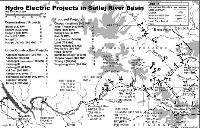
-Sutlej Jal Viduyt Nigam Limited, damming the entire Satluj Basin in India.
“A river flowing to the sea is a waste”- a view held by several water resource developers in India
Welcome to Anthropocene [1],says James Syvitski, a leading oceanographer, geologist and hydrologist from Colorado University who has been studying subsidence of deltas.
Some scientists are now placing Anthropocene, an era marked with human interference with natural systems, at par with geological epochs like Pleistocene and Holocene. It is manifested in many ways. Rivers and associated systems like deltas and floodplains possibly have had to face the maximum brunt of the Anthropocene.
Cutting edge scientists like Prof. Syvitski who study the changes in our deltaic systems seem to reach to a common conclusion: Delta subsidence is now the main driving force for effective sea level rise for many coastal environments. This subsidence is more influential than sea level rise related to global warming and any deltas are sinking much faster than the sea level is rising.
But why are deltas sinking? What is the main reason behind this subsidence which is eating away land and making millions of people more vulnerable?
It has been established that the main reason behind delta subsidence is drastically reducing sediments reaching the delta.Studies estimate that during the past century, there has been a 94% reduction in Krishna’s sediment reaching the delta, 95% reduction from historic load in Narmada, 80% reduction in Indus, 80% reduction in Cauvery, 96% reduction in Sabarmati, 74% reduction in Mahanadi, 74% reduction in Godavari, 50% reduction Brahmani, etc.[2],[3]
But why are sediments not reaching the delta?
Almost unanimous agreement between scientists indicates that the reason behind this drastic decline in sediments is sediment retention by dams and reservoirs in the upstream[4].(Walling and Fang (2003), Vörösmarty et al., 2003; Syvitski et al.,(2005), Erisson et al, (2005), Walling (2008), K Rao et al (2010), H Gupta et al (2012) ). This has been reiterated in IPCC WG II Report, April 2014.[5]
Bhola Island in Bangladesh, eroded by Meghana River. PhotoSrestha Banerjee, Green Clearance Watch
Prof. Syvitski wrote a few words on the issue for SANDRP. He says, “A delta can form only where the sediment volume supplied from a river can overwhelm the local ocean energy (waves, tides, currents). Ocean energy is ceaseless. Engineering of our river systems, largely through the construction of upstream dams and barrages, has reduced this sediment supply. Consequently ocean energy has begun to reduce the size of our deltas, and coastal retreat is presently widespread. Deltas, once the cradle of modern civilizations, are now under threat — some deltas are in peril of lasting only the next 100 years. Sea level is rising due to ocean warming and glacier melting. Incessant mining of groundwater from below a delta’s surface, along with oil and gas extraction, further contribute to our disappearing deltas. At risk are the residences of more than 500 million people, the loss of biodiversity hotspots, major infrastructure (e.g. megacities, ports), and the rice and protein bowls of the world. Every year thousands of people drown due to storm surges and other coastal flooding. Sinking deltas are evidence of the magnitude of the human footprint on our planetary environment. We must learn to do better.” Professor J P Syvitski (U Colorado, Boulder, USA), Chair — International Geosphere-Biosphere Programme (ICSU), Executive Director, the Community Surface Dynamics Modeling System
Large reservoirs trap as much as 80% of the upstream silt. As a result, most rivers are carrying much less sediment, and some rivers (like Krishna, Indus, Nile, and Colorado) transport virtually no sediment! In the last 50 years, the combined annual sediment flux of the large Chinese rivers has been reduced from 1800 million tons (Mt) to about 370 Mt[6]mainly due to frenzied dam building. The impact of dams and reservoirs on sediment retention has been so significant that the resultant reduced sediment load represents a volume of about 730 km3, equivalent to an area of 7300 km2 assuming a 10 m thick bed[7]. Waling (2008) states that about 25 Gt/year of sediment are trapped by large dams each year. IPCC Report (Assessment Report 5, 2014) refers that 34 rivers with drainage basins of 19 million km2 in total show a 75% reduction in sediment discharge over the past 50 years due to reservoir trapping.
Delta Subsidence and Effective Sea Level Rise (ESLR)
While this delta subsidence and sediment retention has several impacts on dense delta population and coastal ecosystems which offer important services, one of the most serious impacts is its direct role in Effective Sea Level Rise. Ericsson and Vorosmarty et al, 2012[8], concluded that decreased accretion of fluvial sediment resulting from sediment retention and consumptive losses of runoff from irrigation (also due to dams) are the primary determinants of ESLR in nearly 70% of studied deltas.
More and more scientists are concluding that climate related sea level rise has a ‘relatively minor influence on delta conditions’, as compared to anthropogenic reasons. As seen above, there is an almost unanimous agreement that dams are the most important factor influencing contemporary land-ocean sediment fluxes.[9] Globally, greater than 50% of basin-scale sediment flux in regulated basins is potentially trapped in artificial impoundments of approximately 45,000 reservoirs (with dams 15 m high) (Vörösmarty et al., 2003; Syvitski etal., 2005) and sediment delivery to deltas has been reduced or eliminated at all scales.[10]Other reasons for delta subsidence include flow diversion by dams, sediment compaction due to groundwater abstraction, oil and gas exploration and mining, etc,.[11]
Deltas, formed by centuries of accretion of rich sediment, are one of the most fertile and densest populated regions across the world. It is estimated that close to half a billion people live on or near deltas, often in megacities.[12] Although constituting a mere 5% of the total landmass, coastal regions sustain almost three-quarters of the world’s population and yield more than half of global gross domestic product (Vorosmarty et al.,2009).
The direct impacts of ESLR and delta subsidence include inundation of coastal areas, saltwater intrusion into coastal aquifers, increased rates of coastal erosion, an increased exposure to storm surges, etc. These threats have implications for hundreds of millions of people who inhabit the deltaic as well as the ecologically sensitive and important coastal wetland and mangrove forests.
Already, some studies are ringing alarm bells. It is estimated that if no mitigation measures are undertaken and sediment retention continues, then by 2050, more than 8.7 million people and 28,000 km2 of deltaic area in 33 deltas studied including Ganga-Brahmaputra, Indus, Krishna and Godavari could suffer from enhanced inundation and increased coastal erosion. In addition, a larger population and area will be affected due to increased flood risk due to storm surges[13]. Conservative estimates state that delta area vulnerable to flooding could increase by 50% under the current projected values for sea-level rise in the 21st century and this could increase if the capture of sediment upstream persists and continues to prevent the growth of the deltas.[14]
The Intergovernmental Panel on Climate Change (IPCC) projects that sea level will rise by another 21 to 71 cm by 2070, with a best estimate of 44 cm averaged globally. This will further compound impacts of delta subsidence and sediment trapping.
It has been estimated that even in the case of debilitating floods, sediment has not reached rivers in the deltas.[15]In 2007–08 alone Ganges, Mekong, Irrawaddy, Chao Phraya, Brahmani, Mahanadi, Krishna and Godavari flooded with more than 100,000 lives lost and more than a million habitants displaced. Most of the deltas that suffered from floods did not receive a significant input of sediment, and this lack of sediment can be attributed to upstream damming.[16] Some studies demonstrate that storage of sediment-laden water of major flood events leads to huge sediment trapping behind mega dams.[17]
Above: Global distribution of ESLR under baseline for each of the 40 deltas studied by Ericsson et al, 2006.From Ericsson et al, 2006
Fluvial Sediments and Deltas in India
Rivers are not only conduits of water. They are a complex, moving systems carrying sediment, nutrients, organisms, ecosystems, energy, material and cultures in their wake.
There are three kinds of sediments: suspended, bed load and wash load. Here we are referring to mainly the suspended sediments in the rivers. Sediments play a significant role in the river geomorphology, defining the river channel, its shape and structure. Sediment deposits form alluvial floodplains, deltas, levees, beaches, ox bow lakes and lagoons and creeks. The sediment load and composition changes according to the river, the geological landscape it flows in, its length, flow, structure, etc. While much of the sediment is deposited by the river on its banks, the delta of the river is primarily formed of rich sediments. Through this deposition, the river may form distributaries at its mouth, like in case of Ganga, Brahmaputra or Mahanadi systems. Ganga-Brahmaputra Delta, shared by India and Bangladesh is one of the largest delta systems in the world, spanning more than 100,000 km2[18]carrying more than one billion tonnes of sediments annually.[19]
Deltaic populations in shared rivers of India, Bangladesh and Pakistan: Population of Ganga-Brahmaputra-Meghana Delta is more than 147 million people with a population density of more than 200 people per km2 (520 people per square mile), making it one of the most densely populated regions in the world . The Krishna Godavari twin deltas supports 9·26 million people inhabiting the 12,700 km2 area at 729 persons per km2, which is more than double the country’s average.[20] Cauvery delta supports 4.4 million people[21] while the Mahanadi Delta too supports millions. Only two districts of Cuttack and Jagatsinghpur have a population more than 3.7 million. (Census 2011) in addition, the contribution of deltas to economics, food production, transport, ecosystem services etc., is immense, making it a very valuable ecosystem which deserves protection. Indus Delta in Pakistan supports more than 900,000 people.
Deltas in Peril: Impact of damming on deltas in India
1. Krishna-Godavari Delta: In 2010, a team led by K Nageswar Rao of Dept of Geo Engineering, Andhra University, carried out an assessment of the impacts of impoundments on delta shoreline recession in Krishna and Godavari Delta.[22] The study revealed a net erosion of 76 km2 of area along the entire 336-km-long twin delta coast during the 43 years between 1965–2008 with a progressively increasing rate from 1·39 km2 per year 1965 and 1990, to 2·32 km2 per year during 1990–2000 and more or less sustained at 2·25 km2 per year during 2000–2008.
For Krishna, flows as well as suspended sediments in the delta have nearly reached zero. Suspended sediment loads decreased from 9 million tons during 1966–1969 to negligible 0·4 million tons by 2000–2005. Syvitski et al in their 2009 assessment place Krishna in the category of “Deltas in Greater Peril: Virtually no aggradation and/or very high accelerated compaction.”
In the case of the Godavari delta, there has been almost a three-fold reduction in suspended sediment loads from 150·2 million tons during 1970–1979 to 57·2 million tons by 2000–2006. Syvistki et al classify Godavari delta as “Deltas in greater risk: reduction in aggradation where rates no longer exceed relative sea-level rise”. H Gupta et al (2012) suggest that decline in historic sediments of Godavari post damming has been as high as 74%.
Above: Graph indicating decadal sediment and water flow trends at Prakassam Barrage, across Krishna. Dam building also marked. From Rao et al, 2010
According to Dr. Rao, a comparison of data on annual sediment loads recorded along the Krishna and Godavari Rivers shows consistently lower sediment quantities at the locations downstream of dams than at their upstream counterparts, holding dams responsible for sediment retention. Reports based on bathymetric surveys reveal considerable reduction in the storage capacities of reservoirs behind such dams. Authors say: “Sediment retention at the dams is the main reason for the pronounced coastal erosion along the Krishna and Godavari deltas during the past four decades, which is coeval[23] to the hectic dam construction activity in these river basins.”
Impacts of this can be seen in destroyed villages like Uppada in Godavari delta, destruction of Mangrove forests and shoreline. Similarly Krishna delta is losing land at the rate of 82·5 ha per year, leading to destruction of mangrove forests and loss of land.
The study concludes: “If the situation continues, these deltaic regions, which presently sustain large populations might turn out to be even uninhabitable in future, considering conditions elsewhere, such as in southern Iraq, where the farmers downstream of dams across Tigris River in Iraq, Syria and Turkey are being forced to migrate to urban centres as the reduced river flows become overwhelmed by seawater.”
I talked with Dr. Rao and asked him, if his disturbing study had any impacts. He said, no one from the administration has contacted him ever about this issue.
Above: Sediments measured at Sir. Arthur Cotton Barrage across Godavari near the Delta from Rao et al, 2010
A similar study by IWMI[24] concludes: “Coastal erosion in the Krishna Delta progressed over the last 25 years (is) at the average rate of 77.6 ha/ yr, dominating the entire delta coastline and exceeding the deposition rate threefold. The retreat of the Krishna Delta may be explained primarily by the reduced river inflow to the delta (which is three times less at present than 50 years ago) and the associated reduction of sediment load. Both are invariably related to upstream reservoir storage development.”
Krishna Basin Water Disputes Tribunal Award, though mentions dam siltation (it mentions that in 5 decades, Tungabhadra Dam has silted up to 22% of its capacity), does not say anything about flow for flushing sediments or its importance to the delta in Andhra Pradesh, or if the “minimum instream flow” recommended by the Tribunal will address this issue. This is a major limitation of the tribunal, when advanced studies have been conducted on the Krishna River delta condition and its relation to upstream dams has been established beyond doubt. Only at one place does it mention that to reduce siltation of the Almatti Dam, sluice gates should be opened when water is flowing above the crest.
However, the Award states that issues like minimum in stream flows are not decided once for all and it is an evolving process. Let us hope that there is some space to address the issue of shrinking deltas through this.
Above:Decreasing Sediments of Krishna down the years from K Rao et al, 2010
In the upstream Maharashtra, more and more dams are under construction in the Krishna Godavari Basin. One of the proposed dams called Kikvi, at the headwaters of Godavari in Trimbakeshwar was cleared by the Forest Advisory Committee recently. Ironically, the proponent (Water Resources Department, Maharashtra and Nashik Municipal Corporation) justified this dam which will submerge more than 1000 hectares of land, by stating that one more large dam close to Kikvi: Gangapur Dam is heavily silted up. [25]Rather than desilting Gangapur Dam, the administration wants to build one more dam.
Above: Trends in Sediments in Godavari and dam building activity. From K Rao et al
Many dams in Krishna Godavari Basin in Maharashtra have been criticised for not contributing to increasing irrigation.[26]These dams are not only obstructing river flow, but are also acting as sediment traps. Unfortunately, the MoEF is not even considering impacts of sediments while appraising dams. In Karnataka, major projects are being undertaken by fraud, without environmental appraisal, violating Environment laws, [27]similarly in Andhra Pradesh, many projects are being pushed illegally without environmental appraisal and which involve huge corruption[28].
2. Cauvery Delta: Although detailed studies have not been carried out, there is a clear indication of salt water intrusion and delta erosion in this over developed basin, due to upstream dams. The saline-freshwater boundary map indicates a steady migration inland.
A study by Gupta et al, 2012, indicates that historical sediment flux of Cauvery was 1.59 million tonnes, which is now 0.32 million tonnes (average of 10 years) and hence, there is a whopping 80% reduction in sediment flux of the river.
Unfortunately, the Cauvery Water Disputes Award Tribunal between Karnataka and Tamilnadu does not even mention the word ‘sediment’ in its award. There has been no justification for 10 TMC feet (Thousand Million Cubic feet) water recommended by the Tribunal for Environmental purposes and its possible impact on sediment carrying (or even environment for that matter).
Pennar showed 77% reduction and Mahanadi showed 67% reduction in amount of silt reaching the delta in recent years. (Gupta et al, 2012)
3. Narmada Delta: The west flowing rivers like Narmada and Tapi do not form extensive deltas like the east flowing rivers. Nonetheless, sediments from a huge river like Narmada play an important part in the stability of Narmada delta and villages and ecosystems around it.
Above: From: H. Gupta et al, 2007 and 2012
Gupta et al (2012 and 2007) assessed daily water discharge and suspended sediment load data measured by CWC at two gauging stations, one upstream of the Sardar Sarovar dam (Rajghat), and another downstream of the dam (Garudeshwar).
Historical sediment discharge of Narmada was found to be 61 million tonnes and the current sediment discharge (average of last ten years of the study) was found to be 3.23 million tonnes, indicating a reduction of 95% sediment discharge.[29] The presence of dam reduces 70–90% of coarse and approximately 50% of medium-sized particles on their way downstream, allowing them to settle in the reservoir Comparative studies of average suspended sediment load at various locations on the Narmada River for more than two decades, show overall reduction in suspended sediment load in the river.
The study indicated 96% reduction in suspended silt flux in Sabarmati, 41% reduction in Tapi and 68% in Mahi.
4. Ganga- Brahmaputra Delta: Different studies put different values for individual and combined sediment load of the Ganga Brahmaputra system, which carries one of the highest sediment loads in the world. According to Islam (1999)[30] Ganges and Brahmaputra rivers in Bangladesh transport 316 and 721 million tonnes of sediment annually. Of the total suspended sediment load (i.e. 1037 million tonnes) transported by these rivers, only 525 million tonnes (c. 51% of the total load) is delivered to the coastal area of Bangladesh and the remaining 512 million tonnes are deposited within the lower basin, offsetting the subsidence. Of the deposited load, about 289 million tonnes (about 28% of the total load) is deposited on the floodplains of these rivers. The remaining 223 million tonnes (about 21% of the total load) is deposited within the river channels, resulting in aggradation of the channel bed at an average rate of about 3.9 cm/yr sediment.
Across the 20th Century, Syvitski et al suggest about 30% reduction of silt load in the river system. Gupta et al [31] suggest that the observed decrease in sediment load could be due to construction of several mega dams in the Ganga basin, closure of Farakka barrage (1974) and diversion of sediments laden water into the Hooghly distributary. They also caution that dams in Ganga and Brahmaputra can worsen the situation.
5. Indus Delta: Inam et al (2007) assessed annual sediment loads of the Indus river at Kotri Barrage (270 km upstream from river mouth) during the last 73 years. The study indicates that annual sediment load of the Indus river has reduced drastically from 193 Mt (between 1931 and 1954) to 13 Mt (between 1993 and 2003). According to them, construction of three large dams on the Indus river, namely Kotri Barrage, Mangla and Terbela led to this situation causing annual water discharge to reduce from 110 km3 to 37 km3, with disastrous impacts on the delta ecosystem and population.
Above: Variation of water and sediment discharge below Kotri Barrage in Indus basin: Inam et al
Dying mangroves in Indus Delta Photo: The Nation
Inam states : “Currently the Indus river hardly contributes any sediment to the delta or Arabian Sea.The active delta is reduced from 6200 km2 before construction of dams to 1200 km2. The sea water has travelled upstream upto 75 kms, combined loss of freshwater and sediment has resulted in loss of large areas of prime delta agricultural land and submergence of several villages in the coast. This has caused desertification and displacement of several hundred of thousands of local residents. Study of records and bathymetric maps from 1950 indicate widespread coastal retreat…The life on the delta is dependent on availability of freshwater and sediment. Severe reduction of both as a result of dams and barrages and associated structures in the upstream has resulted in pronounced erosion in parts of the delta and reduction in mangroves. Environmental studies to be extended to the entire Indus ecosystem from the mountains to the Arabian sea.”
Conclusions
It is clear that deltas and dependent populations and ecosystems have suffered due to near total ignorance about the impact of dams on sediment and deltas and if immediate action is not taken then, this will impact a huge population and a large eco-region in Indian subcontinent, as elsewhere.
The impacts of nutrient rich sediment retention and flow reduction is not limited to teh delta, but has also affected marine fish production[32]
The issue of impact of a dam on the sediment regime of the river is not being studied or considered at all while conducting Environmental Impact Assessments of projects, appraising the project for options assessment, environmental clearance, cost benefit analysis or through post clearance monitoring and compliance.
Sediment release and sediment transport through rivers is not being raised in trans-boundary river negotiations.
Looking at the severity of the issue and its far reaching impacts on millions of people in India and across the world, there is a need for adopting urgent and strong mitigation measures against sediment trapping in dams.
It has to be remembered that for older dams, older hydropower projects and most irrigation projects, there is no mechanism available to flush the accumulated silt.
Sediment retention also reduces the life of the dam, while starving the river and delta in the downstream of sediment. As per a study by SANDRP in 2006, India may be losing 1.95 Billion Cubic Meters of Storage capacity of its reservoirs annually.[33] This implies that the rivers are losing at least that quantity of sediment annually.
The frantic dam activity in Indian Himalayas at this moment will have a serious impact on Ganga Brahmaputra Delta in India and Bangladesh and Indus Delta in Pakistan. There is an urgent need to, firstly, acknowledge these links, assess the impacts, include them in cost benefit and options assessment, address the issues and implement mitigation measures, where relevant, abandon the projects where impacts are unacceptable projects unviable.
In case of the Ganga Brahmaputra delta, recent studies have indicated that the main source of sediment in the river is the Himalayas[34]. Of the entire sediment load of Ganga catchment (This study assumed it to be 794 million tonnes/year), 80+/-10 % comes from High Himalayas and 20+/-10 % comes from Lesser Himalayas.
Bumper to bumper dam/ hydropower project building is occurring in almost all of the Himalayan states in India, which is poised to make Indian Himalayas most densely dammed region in the world. All of these dams are located in the downstream of the Greater and straddling Lesser Himalayas and can together have a tremendous impact on Ganga’s sediment load. Uttarakhand is planning and building nearly 336 Hydroelectric projects,[35]while Sikkim and Himachal Pradesh too are building hundreds of hydro projects. Arunachal Pradesh intends to dam most of its rives to produce hydropower.
No studies on impact of these projects on sediment regime of the rivers are being carried out for; neither does the MoEF insist that projects will not be cleared unless such studies are carried out. Even Cumulative impact assessments are not assessing this aspect.
Some stark examples:
The Cumulative Impact Assessment Report of the Upper Ganga Basin in Uttarakhand [36](where more than one hundred dams are planned and under construction back to back) was doen by IIT Roorkee. This cumulative impact assessment did not study any cumulative impacts due to reduced silt load of the river following major dam push.
The Lohit Basin Study done by WAPCOS[37]which involves more than 12 dams across the Lohit River, one of the three main segments that form Brahmaputra, does not mention anything about impacts of dams on sediments. The only thing it states is very worrying : “Due to substantial storage capacity, the Demwe Upper reservoir will have high sediment retention capacity and a large proportion of sediments carried by the Lohit River will get settled in the reservoir.”
Siang Basin Study [38](by RS Envirolinks Pvt Limited), which involves three mega dams across the main stem Siang, completely obliterating free flowing stretches in the river,in addition to 42 hydropower dams, does not mention anything about sediment regime, although being specifically asked to address this issue by the Expert Appraisal Committee, Union Ministry of Environment & Forests (MoEF).
1500 MW Tipaimukh Mega Dam near Bangladesh Border, which has received Environmental Clearance from MoEF does not study the impacts of sediment retention on downstream Bangladesh, and this concern has been raised by the groups in that country. The Environment Management Plan of this project which can submerge 25000 hectares of forests does not even mention the word “sediment”.
The bumper to bumper dam building activity in Himachal Pradesh in Satluj, Beas, Chenab and Ravi [39]rivers will have a major impact on silt load reaching the Indus river Basin and the Indus Delta in Pakistan. However, none of the EIAs or EMPs mention any impact of the dams on the sediment regime of the river.
In conclusion, although the risks of delta subsidence, effective sea level rise and its impact on a huge population and ecosystems has been established, these risks are being entirely ignored in the current governance surrounding rivers and deltas.
National Centre for Sustainable Coastal Management It is unfortunate to see that MoEF’s National Centre for Sustainable Coastal Management, supported by MoEF and World Bank does not allude to this issue or raise it through any publications.[40] In conversation with SANDRP, Director R. Ramesh said that the center may look at these issues in the future. However, its publications on National Assessment of Shoreline Changes on Tamilnadu and Odisha[41] do not mention upstream dams, although robust evidence exist that Cauvery delta and Mahanadi, Brahmani and Baitarni deltas are eroding due to sediment retention. Let us hope this institute will try to highlight the impact of dams on deltas with the seriousness it deserves.
Recommendations
1. Urgently study impacts of sediment retention by dams on delta population and ecosystems: MoEF, Ministry of Rural Development and Urban Development should conduct an in-depth study to understand the scale of the problems and the extent of affected people and ecosystems due to sediment impoundment by upstream dams.
2.Urgently study the optimal level of sediments (and water regime) needed for stabilising deltas and reducing subsidence.
3. Urgently institute a study to assess the extent of sediment and flows needed to be released from upstream dams and feasibility of such releases on regular basis, mimicking the river’s hydrograph. Where dams have sluice gates, these should be opened in monsoons where feasible, to allow sediment flushing. Even in dry and stressed river basins like Colorado in the United States, such high releases for redistributing sediments have been conducted in the 1990s and again in 2013 with proper planning and impact assessment.[42]
4. In Krishna and such other basins, where delta subsidence, coastal erosion and related impacts like salinity intrusion and storm surges has reached serious proportions, specifically problematic dams should be considered for decommissioning.
Environmental Appraisal Process
Study of impact on sedimentation and siltation should be a part of the environmental impact assessment, environmental appraisal and clearance process.
There should be a separate section in EIA for e-flows and sedimentation studies. Similarly such studies should be mandatory part of cumulative impacts, carrying capacity and basin studies.
More dams in basins which support large deltaic populations and those having significant impacts of sediment retention by reservoirs should not be cleared.Let us hope that this chronically neglected issue receives the attention it deserves. Delta subsidence and ESLR due to upstream damming again highlights the complex and interconnected nature of the riverine ecosystem. The environmental governance in India ( as also South Asia) surrounding rivers has been treating rivers with an extremely piecemeal approach. It is clear that with the herculean challeneges we face now, such an approach is no longer affordable.
~~~~
…especially in the part called Delta, it seems to me that if the Nile no longer floods it, then, for all time to come, the Egyptians will suffer – Herodotus, History, c 442 BC (stated in Patrick McCully’s Silenced Rivers)
For PDF file of this blog, see: https://sandrp.in/Shrinking_and_sinking_delta_major_role_of_Dams_May_2014.pdf
Above: Sediment laden waters of River Elwha reaching the coastal waters after Elwha Dam Removal. From: gallery.usgs.gov
Bibliography
Patrick McCully, Silenced Rivers: The Ecology and Politics of Large Dams, Zed Books, 1996
Islam et al, The Ganges and Brahmaputra rivers in Bangladesh: basin denudation and sedimentation, Hydrological processes, 1999
R.J. Wasson, A sediment budget for the Ganga–Brahmaputra catchment, Current Science, 2003
B Hema Mali et al, Coastal erosion and habitat loss along the Godavari Delta Front: a fallout of dam construction (?), Current Science, 2004
Syvitski et al, Impact of Humans on the Flux of Terrestrial Sediment to the Global Coastal Ocean, 2004
Jason P. Ericsson, Charles J. Vörösmarty S. Lawrence Dingmanb,2Larry G. Ward Effective sea-level rise and deltas: Causes of change and human dimension implications, 2006
Michel Meybeckve et al Sea-level rise and deltas: Causes of change and human dimension implications
Inam et al The Geographic, Geological and Oceanographic Setting of the Indus River, Wiley and Sons, 2007
Walling et al, The Changing sediment loads of world’s rivers, Annals of Warsaw University of Life Sciences, 2008
Syvitski et al, Sinking deltas due to human activities, Nature Geoscience, 2009
Gamage et al. Do river deltas in east India retreat? A case of the Krishna Delta, Geomorphology, Volume 103, Issue 4, 15 February 2009
K Nageswar Rao et al Impacts of sediment retention by dams on delta shoreline recession: evidences from the Krishna and Godavari deltas, India, Earth surface processes and landforms, 2010
James Syvitski et al, Sediment flux and the Anthropocene published 31 , doi: 10.1098/rsta.2010.0329 369 2011 Phil. Trans. R. Soc. A, January 2011
H Gupta et al , The role of mega dams in reducing sediment fluxes: A case study of large Asian rivers, Journal of Hydrology, 2012
[6] The role of mega dams in reducing sediment fluxes: A case study of largeAsian riversHarish Guptaa,⇑, Shuh-Ji Kaoa,b, Minhan Daia
[7] Sediment flux and the Anthropocene James P. M. Syvitski and Albert Kettner January 2011, published 31 , doi: 10.1098/rsta.2010.0329 369 2011 Phil. Trans. R. Soc. A
[8] Effective sea-level rise and deltas: Causes of change and human dimension implications
Jason P. Ericsona, Charles J. Vörösmartya,b,1, S. Lawrence Dingmanb,2Larry G. Ward
b, Michel Meybeckve Sea-level rise and deltas: Causes of change and human dimension implications Jason P. Ericson a,⁎, Charles J. Vörösmartya,b,1, S. Lawrence Dingmanb,2Larry G. Ward b, Michel Meybeck
[9] Walling and Fang (2003), Vörösmarty et al., 2003; Syvitski et al.,(2005), Erisson et al, (2005), Walling (2008)
[10] Syvitski et all 2009
[11] Sinking deltas due to human activities, Syvitski et al, 2009, Nature Geoscience
[12] Sinking deltas due to human activities, Syvitski et al, 2009, Nature Geoscience
[13] Ericsson et all, 2006, Effective sea-level rise and deltas: Causes of change and human dimension implications
[14] Sinking deltas due to human activities, Syvitski et al, 2009, Nature Geoscience
[15]Syvitski et al 2009
[16]Syvitski et all 2009
[17] Harish Guptaa, et al The role of mega dams in reducing sediment fluxes: A case study of large Asian rivers
[20] K Nageshwar Rao et al, 2010, Impacts of sediment retention by dams on delta shoreline recession: evidences from the Krishna and Godavari deltas, India Earth surface processes and landforms
[22] K Nageshwar Rao et al, 2010, Impacts of sediment retention by dams on delta shoreline recession: evidences from the Krishna and Godavari deltas, India Earth surface processes and landforms
[23] Time period or age
[24] Do river deltas in east India retreat? A case of the Krishna Delta Nilantha Gamage Geomorphology, Volume 103, Issue 4, 15 February 2009, Pages 533–540
Inter-governmental Panel on Climate Change’s (IPCC) Fifth Assessment is falling into place. On the 31st March 2014, the report titled ‘Climate Change 2014: Impacts, Adaptation, and Vulnerability’, from Working Group II[1] was issued in Yokohoma, Japan. Working Group II assesses “the vulnerability of socio-economic and natural systems to climate change, negative and positive consequences of climate change, and options for adapting to it. It also takes into consideration the inter-relationship between vulnerability, adaptation and sustainable development.”[2]
This can be called as one of the more incisive Working Group Reports from IPCC. It states unequivocally that the effects of climate change are already occurring on all continents and across the oceans and world is ill-prepared for risks from a changing climate. According to Co-Chair of Working Group II, Chris Field, “The report concludes that people, societies, and ecosystems are vulnerable around the world, but with different vulnerability in different places. Climate change often interacts with other stresses to increase risk”.[3]
The report consists of two volumes. First volume contains a Summary for Policymakers, Technical Summary, and 20 chapters assessing risks by sector and opportunities for response. The sectors include freshwater resources, terrestrial and ocean ecosystems, coasts, food, urban and rural areas, energy and industry, human health and security, and livelihoods and poverty. A second volume of 10 chapters assesses risks and opportunities for response by region. These regions include Africa, Europe, Asia, Australasia, North America, Central and South America, Polar Regions, Small Islands, and the Ocean.
The summary for policymakers paints a sombre picture: “Climate change over the 21st century is projected to reduce renewable surface water and groundwater resources significantly in most dry subtropical regions, intensifying competition for water among sectors. In presently dry regions, drought frequency will likely increase by the end of the 21st century under RCP8.5. In contrast, water resources are projected to increase at high latitudes. Climate change is projected to reduce raw water quality and pose risks to drinking water quality even with conventional treatment, due to interacting factors: increased temperature; increased sediment, nutrient, and pollutant loadings from heavy rainfall; increased concentration of pollutants during droughts; and disruption of treatment facilities during floods. Adaptive water management techniques, including scenario planning, learning-based approaches, and flexible and low-regret solutions, can help create resilience to uncertain hydrological changes and impacts due to climate change.”
“Risks are unevenly distributed and are generally greater for disadvantaged people and communities in countries at all levels of development.”
Links with water
Being an integral and cross cutting issue, water features prominently in all of Chapters of the Working Group Report. Sections on Freshwater Resources, Costal systems and low lying areas, Food Security, Inland systems, etc. include important findings. It is significant to note that dams, hydropower projects, infrastructure measures like channelization, embankments, etc., are also mentioned in nearly all the chapters of the report. Couple of references indicate dams as a possible adaptation measure, but overwhelming references point to the contrary.
The collective picture that is arising through these reference is very important. A collation and analysis of all specific references to water infrastructure projects, read in tandem with the report indicates that:
1. Dams and infrastructure projects contribute significantly to “non-climate impacts” which, after interacting with changing climate, exacerbate the overall impact on human societies and ecosystems
o Sediment Trapping by reservoirs, exacerbates impact of sea level rise
o Hydropower affects local options
o Climate change and dams together affect a greater eco-region
o Increased flow fluctuations by dams exacerbate through climate change
2. In case of Flood Protection, dams and embankments may do more harm than good. Ecological measures would fare better.
3. Dams and Hydropower projects affect biodiversity, which is critical in facing climate change challenges.
4. In the tropics, global warming potential of hydropower may exceed that of Thermal Power
5. Dams increase vulnerability of weaker sections to climate change
6. Existing Dams have to be managed sustainably, with ecological considerations
7. Hydropower itself is vulnerable to Climate Change
~~~
The references used in WG II report are peer reviewed research from several authors.The specific references given below will play an important role in debunking the simplistic myth that dams and hydropower projects are climate friendly and can be considered as de facto adaptation measures to cope with Climate Change.
Some Relevant Extracts from Working Group II Report:
Dams and infrastructure projects contribute significantly to “non-climate impacts” which, after interacting with climate impacts, exacerbate the overall impact of climate change on human societies and ecosystems
Sediment Trapping by reservoirs, exacerbates impact of sea level rise
“Most large deltas in Asia are sinking (as a result of groundwater withdrawal, floodplain engineering, and trapping of sediments by dams) much faster than global sea-level is rising.” (Chapter 24: Asia)
“Human activities in drainage basins and coastal plains have impacted the coastal zone by changing the delivery of sediment to the coast. Sediment trapping behind dams, water diversion for irrigation, and sand and gravel mining in river channels all contribute to decrease sediment delivery, whereas soil erosion due to land-use changes help increase it. It is estimated that the global discharge of riverine sediment was 16-–19 Gt/ yr in the 1950s before widespread dam construction and it has decreased to 12–13 Gt/ yr. Out of 145 major rivers with mostly more than 25-year record, only 7 showed evidence of an increase in sediment flux while 68 showed significant downward trends. The number of dams has increased continuously and their distribution has expanded globally. As of early 2011, the world has an estimated 16.7 million reservoirs larger than 0.01 ha. Globally, 34 rivers with drainage basins of 19 million km2 in total show a 75% reduction in sediment discharge over the past 50 years. Reservoir trapping of sediments is estimated globally as 3.6 Gt/ yr to more than 5 Gt/ yr (Syvitski et al., 2005; Walling, 2012; Milliman and Farnsworth, 2011). Human pressure is the main driver of the observed declining trend in sediment delivery to the coastline.(Chapter 5 Coastal systems and Low Lying areas)
“Attributing shoreline changes to climate change is still difficult due to the multiple natural and anthropogenic drivers contributing to coastal erosion.” (Chapter 5 Coastal systems and low lying areas)
“The combined impact of sediment reduction, relative sea level rise, land-use changes in delta and river management on channels and banks has led to the widespread degradation of deltas. The changes of sediment delivery from rivers due to dams, irrigation and embankments/dykes creates an imbalance in sediment budget in the coastal zones. Degradation of beaches, mangroves, tidal flats, and subaqueous delta fronts along deltaic coasts has been reported in many deltas (e.g. Nile and Ebro, Sanchez-Arcilla et al., 1998; Po, Simeoni and Corbau, 2009; Krishna-Godavari, Nageswara Rao et al., 2010; Changjiang, Yang et al., 2011; Huanghe, Chu et al., 1996; very high confidence). Deltaic coasts naturally evolve by seaward migration of the shoreline, forming a delta plain. However, decreasing sediment discharge during the last 50 years has decreased the growth of deltaic land, even reversing it in some locations (e.g. Nile, Godavari, Huanghe). Artificial reinforcement of natural levees also has reduced the inter-distributory basin sedimentation in most deltas, resulting in wetland loss.” (Emphasis added.)
“The major impacts of sea level rise are changes in coastal wetlands, increased coastal flooding, increased coastal erosion, and saltwater intrusion into estuaries and deltas, which are exacerbated by increased human-induced drivers. Ground subsidence amplifies these hazards in farms and cities on deltaic plains through relative sea level rise. Relative sea level rise due to subsidence has induced wetland loss and shoreline retreat (e.g. the Mississippi delta, Morton et al., 2005; Chao Phraya delta, Saito et al., 2007; high confidence).” (Chapter 5 Coastal systems and low lying areas)
“There have been local variations in precipitation and runoff since 1950, but changes in sediment load are primarily attributed to over 50,000 dams and vegetation changes.” (Chapter 18: Detection and attribution of observed impacts)
Hydropower affects local options
“Hydropower dams along the Mekong River and its tributaries will also have severe impacts on fish productivity and biodiversity, by blocking critical fish migration routes, altering the habitat of non-migratory fish species, and reducing nutrient flows downstream. Climate impacts, though less severe than the impact of dams, will exacerbate these changes.”(Chapter 24: Asia)
Climate change and dams together affect a greater eco-region
“For one climate scenario, 15% of the global land area may be negatively affected, by the 2050s, by a decrease of fish species in the upstream basin of more than 10%, as compared to only 10% of the land area that has already suffered from such decreases due to water withdrawals and dams (Döll and Zhang, 2010). Climate change may exacerbate the negative impacts of dams for freshwater ecosystems.” (Chapter 3: Freshwater resources)
Flood Protection: Dams and embankments may do more harm than good. Ecological measures fare better.
“On rivers and coasts, the use of hard defences (e.g. sea-walls, channelization, bunds, dams) to protect agriculture and human settlements from flooding may have negative consequences for both natural ecosystems and carbon sequestration by preventing natural adjustments to changing conditions. Conversely, setting aside landward buffer zones along coasts and rivers would be positive for both. The very high carbon sequestration potential of the organic-rich soils in mangroves and peat swamp forests provides opportunities for combining adaptation with mitigation through restoration of degraded areas.” (Chapter 3 Freshwater Resources)
“Ecosystem based adaptation (EBA) can be combined with, or even a substitute for, the use of engineered infrastructure or other technological approaches. Engineered defenses such as dams, sea walls and levees adversely affect biodiversity, potentially resulting in maladaptation due to damage to ecosystem regulating services. There is some evidence that the restoration and use of ecosystem services may reduce or delay the need for these engineering solutions. EBA offers lower risk of maladaptation than engineering solutions in that their application is more flexible and responsive to unanticipated environmental changes. Well-integrated EBA can be more cost effective and sustainable than non-integrated physical engineering approaches (Jones et al., 2012), and may contribute to achieving sustainable development goals (e.g., poverty reduction, sustainable environmental management, and even mitigation objectives), especially when they are integrated with sound ecosystem management approaches.” (Chapter 3 and Also Chapter 15 Adaptation Planning and Implementation)
Dams and Hydropower projects affect biodiversity, which is critical in facing climate change challenges
“Freshwater ecosystems are considered to be among the most threatened on the planet. Fragmentation of rivers by dams and the alteration of natural flow regimes have led to major impacts on freshwater biota.” (Chapter 4: Terrestrial and Inland Water Systems)
“Damming of river systems for hydropower can cause fragmentation of the inland water habitat with implications for fish species.” (Chapter 4 Terrestrial and Inland Water Systems)
“Freshwater ecosystems are also affected by water quality changes induced by climate change, and by human adaptations to climate-change induced increases of streamflow variability and flood risk, such as the construction of dykes and dams”. (Chapter 3: Freshwater resources)
“Hydropower generation leads to alteration of river flow regimes that negatively affect freshwater ecosystems, in particular biodiversity and abundance of riverine organisms, and to fragmentation of river channels by dams, with negative impacts on migratory species. (Chapter 3: Freshwater Resources)
“Hydropower operations often lead to discharge changes on hourly timescales that are detrimental to the downstream river ecosystem.”
“Climate change and habitat modification (e.g., dams and obstructions) impact fish species such as salmon and eels that pass through estuaries.” (Chapter 5 Coastal Systems and low lying areas)
In Tropics, global warming potential of hydropower may exceed Thermal Power
“In tropical regions, the global warming potential of hydropower, due to methane emissions from man-made reservoirs, may exceed that of thermal power; based on observed emissions of a tropical reservoir, this might be the case where the ratio of hydropower generated to the surface area of the reservoir is less than 1 MW/km2”.
“Reservoirs can be a sink of CO2 but also a source of biogenic CO2 and CH4” (Chapter 4 Terrestrial and Inland Systems)
Dams increase vulnerability of weaker sections to climate change
“A number of studies recognize that not every possible response to climate change is consistent with sustainable development, since some strategies and actions may have negative impacts on the well-being of others and of future generations .For example, in central Vietnam some responses to climate change impact, such as building dams to prevent flooding and saltwater intrusion and to generate power, threaten the livelihood of poor communities. First, the relocation of communities and the inundation of forestland to build dams limit households’ access to land and forest products. Second, a government focus on irrigated rice agriculture can reduce poor households’ ability to diversify their income portfolio, decreasing their long-term adaptive capacity. Indeed, the consequences of responses to climate change, whether related to mitigation or adaptation, can negatively influence future vulnerability, unless there is awareness of and response to these interactions. Here, the role of values in responding to climate change becomes important from a variety of perspectives, including intergenerational, particularly when those currently in positions of power and authority assume that their prioritized values will be shared by future generations. (Chapter 20: Climate-resilient pathways: adaptation, mitigation, and sustainable development)
“Some documented impacts on dams, reservoirs and irrigation infrastructure are: reduction of sediment load due to reductions in flows (associated with lower precipitation), positively affecting infrastructure operation (Wang et al., 2007); impacts of climate variability and change on storage capacity that creates further vulnerability; and failures in the reliability of water allocation systems (based on water use rights) due to reductions of streamflows under future climate scenarios” (Chapter 9: Rural Areas)
“Infrastructure (e.g. roads, buildings, dams and irrigation systems) will be affected by extreme events associated with climate change. These climate impacts may contribute to migration away from rural areas, though rural migration already exists in many different forms for many non-climate-related reasons.” (Chapter 9 Rural Areas)
“Changes in water use, including increased water diversion and development to meet increasing water demand, and increased dam building will also have implications for inland fisheries and aquaculture, and therefore for the people dependent on them” .
“In the case of the Mekong River basin, a large proportion of the 60 million inhabitants are dependent in some way on fisheries and aquaculture which will be seriously impacted by human population growth, flood mitigation, increased offtake of water, changes in land use and overfishing, as well as by climate change. Ficke et al. (2007) reported that at that time there were 46 large dams planned or already under construction in the Yangtze River basin, the completion of which would have detrimental effects on those dependent on fish for subsistence and recreation.” (Chapter 7 Food security and food production systems)
Existing Dams have to be managed sustainably, with ecological considerations:
“Suggested strategies for maximizing the adaptive capacity of ecosystems include reducing non-climate impacts, maximizing landscape connectivity, and protecting ‘refugia’ where climate change is expected to be less than the regional mean. Additional options for inland waters include operating dams to maintain environmental flows for biodiversity, protecting catchments, and preserving river floodplains.” (Chapter 24:Asia )
Hydropower itself is vulnerable to Climate Change
“Climate change affects hydropower generation through changes in the mean annual stream-flow, shifts of seasonal flows and increases of stream-flow variability (including floods and droughts) as well as by increased evaporation from reservoirs and changes in sediment fluxes. Therefore, the impact of climate change on a specific hydropower plant will depend on the local change of these hydro-logical characteristics, as well as on the type of hydropower plant and on the (seasonal) energy demand, which will itself be affected by climate change”
“Projections of future hydropower generation are subject to the uncertainty of projected precipitation and stream-flow. In regions with high electricity demand for summertime cooling, this seasonal stream-flow shift is detrimental. In general, climate change requires adaptation of operating rules which may, however, be constrained by reservoir capacity. Storage capacity expansion would help increase hydropower generation but might not be cost-effective.”
“Observations and models suggest that global warming impacts on glacier and snow-fed streams and rivers will pass through two contrasting phases. In the first phase, when river discharge is increased due to intensified melting, the overall diversity and abundance of species may increase. However, changes in water temperature and stream-flow may have negative impacts on narrow range endemics. In the second phase, when snowfields melt early and glaciers have shrunken to the point that late-summer stream flow is reduced, broad negative impacts are foreseen, with species diversity rapidly declining once a critical threshold of roughly 50% glacial cover is crossed.” (Chapter 3 Freshwater Resources)
Let us hope that these collated finding will be helpful in addressing the myth that dams and hydropower projects are climate friendly and can even be looked at as adaptation measures. Let us also hope that the Working Group III Report, which will come out in less than a week’s time from now, will have lessons for hydropower development in line with the above statements in the WG II report.
Issues with WG III, Special Report on Renewable Energy
Findings of WG II contrast strikingly with Special Report on Renewable Energy Sources and Climate Change Mitigation (SRREN) [4]brought out by Working Group III in 2011.
One of the two lead coordinating authors of this report was Dr. Arun Kumar, from AHEC, IIT Roorkee. Notably, Dr. Kumar was also a part of the team which worked on Cumulative Impact Assessment of Hydropower projects in Upper Ganga basin of Uttarakhand[5]. The state suffered huge flood and precipitation damages in June 2013 (long after the report came out) and commissioned and under–construction hydropower projects had a large role to play in compounding the impacts of the disaster[6]. Ministry of Environment and Forests as well as the Supreme Court of India rejected this report. SANDRP had published a detailed critique of this CIA report at the outset.
Amazingly, the Hydropower Section of the above mentioned IPCC Special Report on Renewable Energy severely downplays and ignores the impacts of hydropower. For example, it does not allude to peoples protests to projects, impacts of projects by blasting and tunneling, downstream impacts, impacts of peaking, associated deforestation and related development, cumulative impacts of projects in a cascade, increasing climate vulnerability of the population, seismic impacts, increased disaster vulnerability of the region, etc.,. In fact, these impacts have been some of the most-discussed issues in hydropower discourse in many countries at the moment. The report makes strange statements like “trans-boundary hydropower establishes arena for international cooperation”, when we see across the world that hydropower projects on internationally shared rivers further conflicts and strife between nations. It also downplays methane emissions from hydropower.
In all, the section appears biased towards hydropower and does not do justice to IPCC’s rigorous and objective standards. The section should not have been accepted as it stands now.
Now, the Working Group III is yet to submit its Assessment Report to the IPCC. It will be discussed by the IPCC between 7-11 April 2014, in Berlin. We hope there is true depiction of hydropower in the Working Group III report, looking at the above mentioned impacts and also keeping in mind strong statements from Working Group II report made public on March 31, 2014.
Parineeta Dandekar, parineeta.dandekar@gmail.com
~~~
[1] The IPCC Working Group I (WG I) assesses the physical scientific aspects of the climate system and climate change. Working Group II (WG II) assesses the vulnerability of socio-economic and natural systems to climate change, negative and positive consequences of climate change, and options for adapting to it. It also takes into consideration the inter-relationship between vulnerability, adaptation and sustainable development. The assessed information is considered by sectors (water resources; ecosystems; food & forests; coastal systems; industry; human health) and regions (Africa; Asia; Australia & New Zealand; Europe; Latin America; North America; Polar Regions; Small Islands). The IPCC Working Group III (WG III) assesses options for mitigating climate change through limiting or preventing greenhouse gas emissions and enhancing activities that remove them from the atmosphere. (https://www.ipcc.ch/working_groups/working_groups.shtml)
The theme of this World Water Day, 2014 is Water and Energy. The occasion gives us an opportunity to take a look at the hydropower rush going on in the country at this moment.
Hydropower projects are being incessantly pushed from the highest quarters ( including the Prime Minister’s Office, through the formulation of Cabinet Committee on Investment, Ministries like Power, Private dam lobbies, etc.,) . Some environmentalists do not seem to bat an eyelid while labelling ALL hydropower as “Green”. (Director General of CSE was a part of the Kasturirangan Committee report which certified all hydro as green, did not object to two of the most destructive projects: Gundia and Athirappilly, did not stress that mini hydel projects should be appraised for their impacts)
Satluj, downstream Nathpa Jhakri Dam Photo: SANDRP partners
Despite its far reaching impacts, the general perception about hydropower, consciously pushed by developers, funders like World Bank [1]and ADB and also institutions is that they are ‘clean, green and sustainable’. ( The overall understanding of institutions like World Bank on the water-energy nexus is itself limited, as is highlighted by this critique by Shripad Dharmadhikary.[2])
With impacts of HEPs and protests from local communities increasing, we need to check these premises which blindly give a “Green and Clean” certificate to all hydropower, without qualification. On the occasion of the World Water Day, we attempt to look at some impacts of HEPs planned across India on ecosystems and local communities, the existing environmental governance and the justification behind pushing these projects.
Whither River? A typical HEP impounds water behind a dam, transfers it through a Head Race Tunnel (HRT) to the powerhouse where electricity is generated and transfers water back into the river through a Tail Race Tunnel (TRT). Prima facie, supporters of hydropower claim that water is returned to the river and hence hydropower is a renewable and green. However, the tunnels that carry water from dam to the powerhouse and back tend to be kilometers long, effectively drying the river between. Even for one project, this can be a long stretch. 588 MW Luhri HEP in Himachal Pradesh, on Sutlej will have Asia’s longest tunnel of 38.14 kms bypassing the river for 50 kms. Upstream Luhri, there are 3 dams bumper to bumper: 412 MW Rampur, 1500 MW Nathpa Jhakri and 1000 MW Karcham Wangtoo. Effectively, the entire river will flow through tunnels made by blasting fragile Himalayan Mountains or through stagnant waters behind dams. Same is the case of the Teesta basin in Sikkim and many other rivers.
Along with rivers, the aquatic biodiversity, specialist riparian forests, forests in submergence zones, groundwater recharge zones, habitats to numerous wild animals, watering holes of wildlife and communities too are being destroyed.[3] Seventy hydroelectric Projects in Uttarakhand will submerge more than 3,600 hectares of forests. Dibang Multipurpose HEP in Arunachal alone can submerge 5,056 hectares of forest while the Tipaimukh HEP in Manipur can submerge an unbelievable 25, 822 hectares of forest, providing 1 MW installed capacity for 16 hectares of forest submerged.
Diurnal fluctuations and impacts of peaking When the releases from power houses eventually meet the rivers, there is a huge fluctuation on a daily basis in the water level in the downstream. For example, in case of the 1,750 MW Demwe Lower HEP on the Lohit in Arunachal Pradesh, the water level fluctuations 100 kilometers downstream in the Lohit River at Dibru Saikhowa National Park will range from 70 cumecs to 1920 cumecs, each day in the lean season. This is a level fluctuation of 3-5 feet every day in the plains![4] In case of the Siang River, if all dams on the main stem and tribuataries are constructed, water level in the downstream DErring National Park will flucatute beween 23 feet everyday in the lean season![5]
Run ‘with’ the River Projects? Project Proponents, industry and even official committees are claiming that Run of the River (ROR) Projects are green as they do not involve major storage and do not alter the rivers flow over a 10 day period. ROR thus get an official tag of sustainability. In reality, most of the ROR Projects involve massive dams and massive storages behind these dams. They involve reservoirs which run upto ten or more kilometers.For example, the reservoir og Luhri will be 6.8 km long; Kotli Bhel IB will be 27.5 km, Kotli Bhel 2 will be 31.21 km and Lower Demwe will be 23 kms long.
At the same time, for the riverine ecosystem and downstream population, the daily fluctuations in the river levels is devastating. Over a hundred people have died in India due to sudden release of water from upstream hydro projects in non-monsoon months.
Impacts on the aquatic ecosystem: HEPs alter the master variable which governs major riverine processes: its flow.[6] Dams physically block upstream and downstream migration of fish species crucial for their spawning. Fragmentation of rivers, water fluctuation, dry river stretches and passage through turbines have a disastrous impact on fisheries and fish diversity which has been collapsing in all major rivers in country, mainly due to dams.[7]
Himachal Pradesh Fisheries Department has a ‘Negative list’ of rivers and streams rich in biodiversity where in situ protection of fisheries should take place[8]. Ironically, even in this region, hydropower plants are being sanctioned and set up, sometimes in cascades.
Dried Baspa River downstream Baspa Dam. Baspa River supported rich fisheries and fish diversity Photo: SANDRP Partners
There are no provisions for fish migration like fish passages and ladders, eflows. For example the 300 MW Baspa II HEP on Baspa River, in the negative list for fisheries does not have a fish ladder, and has been drying the river without e-flows. Fisheries Departments in Himalayan as well as Western Ghat States have become rubber stamps for providing No Objection Certificates to HEPs while taking monitory compensation. Himachal Fisheries department charges Rs 50,000 per kilometer and additionally, Rs 50,000 Per MW electricity generated as compensation. This means windfall profits to Fisheries departments and nothing to actual fish diversity that is being destroyed.
Hydel Power Dams coming up in the Western Ghats like the 163 MW Athirappilly and 200 MW Gundia will affect endemic and endangered fish diversity in the region, which is not mentioned in the cut paste EIAs of these projects. While WGEEP report categorically rejected both these projects, the HLWG headed by Dr Kasturirangan did not reject them. Instead it simply asked for a revaluation.
The 780 MW Nyamjangchu Project to come up in Tawang region of Arunachal Pradesh threatens one of the last remaining wintering sites of the Black Necked Crane and habitat of Red Panda, though the EIA of the project did not mention this fact. While the Cumulative Impact Assessment report on Upper Ganga HEPs submitted by Wildlife Institute of India recommended dropping 24 HEPs for their irreversible impacts on ecology, but the report of the IMG on Ganga Projects headed by B K Chaturvedi rejected this without giving any reasons.
Disaster potential[9] A critical issue left unaddressed in the environmental clearance, forest clearance and even report of committees like IMG on Ganga and HLWG on Western Ghats is the assessment of disaster potential of hydropower projects. Deforestation, building activities, boulder mining, tunneling and blasting, integral with hydropower projects in the Himalayas make the young mountain more prone to landslides and rivers more flood prone. Impoundment and water level fluctuations play a major role in landslides.
EIAs of mega projects like Luhri, which plans to have world’s longest tunnel does not even include impacts of this tunnel in EIA Report submitted by CISHME team. In the recent Uttarakhand disaster, projects like 400 MW VishnuPrayag, 330 MW Srinagar, 76 MW Phata Byung, 99 MW Singoli Bhatwari, 304 and 90 MW Maneri Bhali I and II & 280 MW Dhauli Ganga hugely increased the damages and loss of lives. If more projects on Alaknanda, Mandakini and Bhagirathi, cleared by MoEF and IMG, were present, losses would have been higher. However, there are studies after studies which do not mention the disaster potential of projects, like the recent Siang Basin Study.[10]
Muck disposal – an example of impacts of non-compliance Throughout the Himalayan states, rivers are littered and changing courses due to millions of tonnes of muck illegally dumped by the HEPs in the riverbed itself. This muck dumped by 330 MW Srinagar Project in Alaknanda bed hugely increased the disaster in Srinagar Town. Muck disposal plans of HEPs remain resolutely on paper, whereas on ground, muck is dumped at the most convenient sites: the riverbed. MoEF has refused to take action even when presented with evidence. The IMG report missed most of these ground realities.
Major struggles From Lahaul Spiti in the glacial north, Singoli Bhatwari & Phata Byung in Uttarakhand, to Subansiri Lower and Tawang in the North east, to the Athirappilly in Western Ghats of Kerala, most of the large (and also small) HEPs are being opposed strongly by local communities. India is witnessing one of its largest anti dam stir against the 2000 MW Lower Subansiri HEP in Assam where construction on the project has been stalled for 20 months. Why are the communities resisting at this scale? Why are litigations surrounding HEPs increasing? Do the communities have any role while decisions are taken in Delhi and private proponent’s offices about destroying their rivers? The answer is no.
Climate Friendly façade of Large Hydro: Large Hydro promoters, government, funders like World Bank and ADB as well as research institutions are supporting HEPs because of the claimed climate friendly nature of the projects.
This is hugely misleading. World over, HEPs are being increasingly recognized as being ‘False Solutions to Climate Change’. Reservoirs of HEPs (including RORs) emit Methane which is 21 times more potent as a greenhouse gas than Carbon dioxide. This emission is further boosted at each draw down of the dam.[11]
The trouble is, we have not conducted a single credible greenhouse gas emission study for any of India’s so-called ‘climate friendly’ hydros. The only project where this was a condition laid while granting a hasty environmental clearance was the 1000 MW Tipaimukh HEP. But here too, after 5 years of granting the EC the study has not been conducted. There is no logic behind labeling large hydro as climate friendly. On the other hand through deforestation, drying up of rivers, destruction of ecological services, instability, increased risks of landslides and flash floods, the adaptation and mitigation potential of local communities to Climate Change is hugely compromised.
With Climate change, Glaciers in Himalayas are receding faster than those at other mountains (ICIMOD). This is leaving moraine debris on the path of receding glacier, building up into moraine dams which can fail catastrophically, as was witnessed in Kedarnath disaster. In this scenario, hydropower dams, which depend largely on glacial melt are not only vulnerable to climate change, but have catastrophic impacts on the downstream population as was witnessed in Uttarakhand in case of 400 MW Vishnuprayag and 330 MW Srinagar Projects. Hence, claiming that HEPs in India are important from climate change perspective is unscientific.
Environmental governance: As per SANDRPs analysis, the Expert Appraisal Committee granting environmental clearance to River valley projects has not rejected a single project of the 262 project considered in last six years ending in Dec 2012[12]. Even when local groups and organisations like SANDRP have raised concerns about impacts of HEPs on rivers, ecosystems and communities, these have been routinely sidelined. While sanctioning cascades of HEPs, no credible CIAs or basin studies or carrying capacity studies are being performed. IMG report on Upper Ganga Projects has also come across as a huge disappointment in this aspect.[13]
Destroyed 400 MW Vishnuprayag HEP on Alaknanda. Photo: Matu Jan Sangathan
MoEF has openly stated that it does not have the capacity to ensure environmental compliance of clearance conditions and environment management plan. In the absence of any enforcement, violations have become a norm. Neither has the MoEF thought of stalling Environmental and Forest Clearancesof HEPs unless streamlined compliance is enforced, like it did for the case of Goa Mines.The pressure of lobbies seems to have blinded precautionary principle or democratic governance at all levels.
It may be noted that 50% of our existing HEPs are generating at less than 50% of their designed 90% dependable generation[14], while nearly 89% projects generate at below the promised levels! Per MW generation has fallen by about 25% in last two decades. On the other hand, micro-hydel projects are making remote places like Anjaw in Arunachal power secure without major impacts.
Sustainable development cannot be achieved by poor environmental governance, by discouraging community participation, by excluding affected communities from decision-making while externalizing impacts on local communities, ecology and future generations. Energy security and access to energy to poor and disadvantaged sections of the society is a very real challenge and there are ways to address this challenge, which are not ecologically and socially destructive. Let us hope that the Water-Energy Nexus also upholds the rights of the rivers and its people.


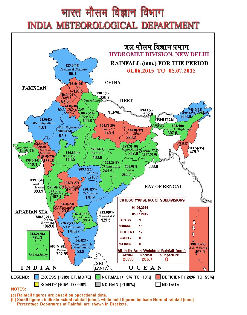


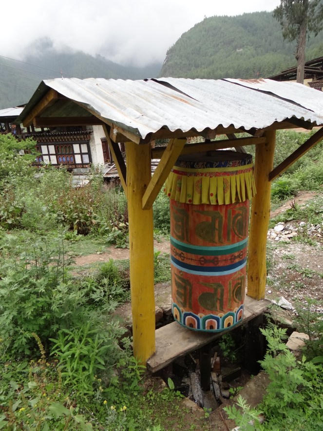


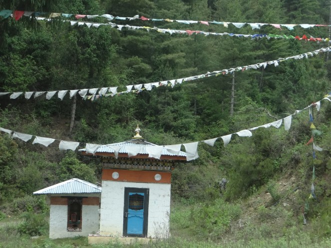


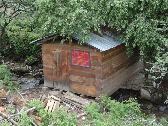


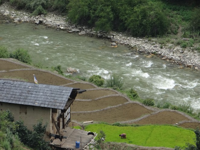


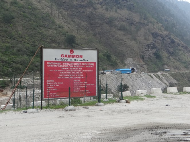








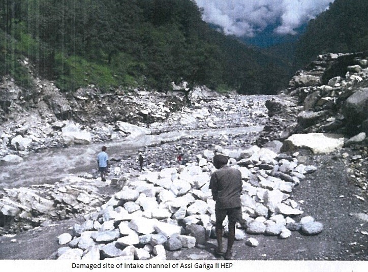


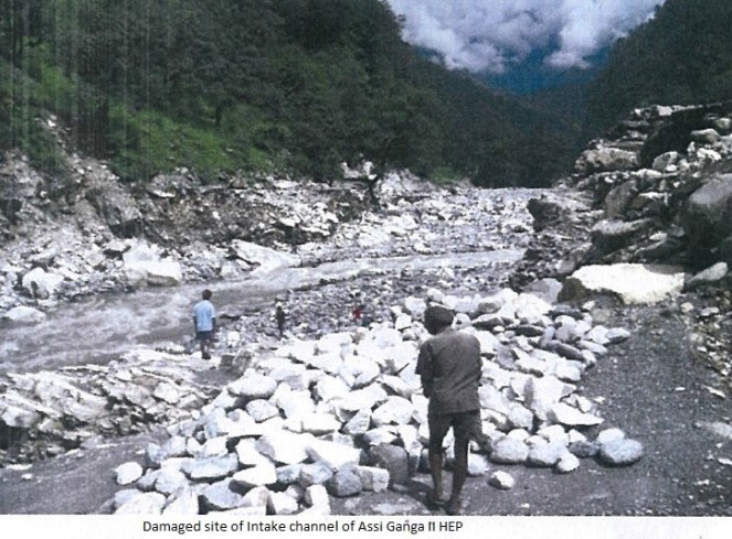
 Kaldigarh HEP (9 MW in Uttarkashi district) The project heavily damaged in 2012 floods and it being in Eco Sensistive zone, the report says the project should not be allowed to restart without permission from central govt.
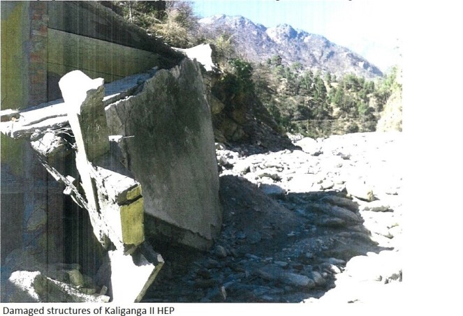
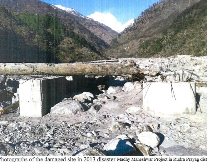
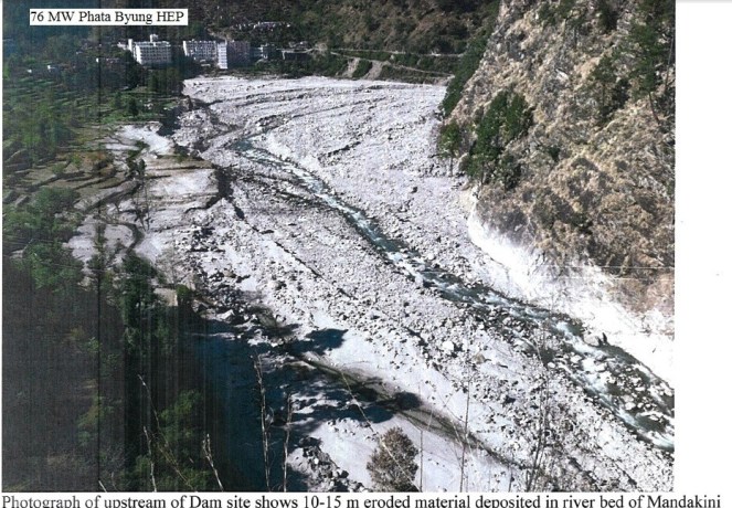
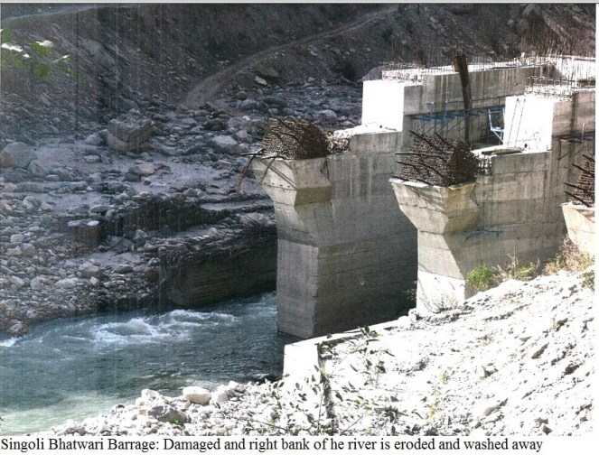


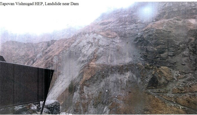


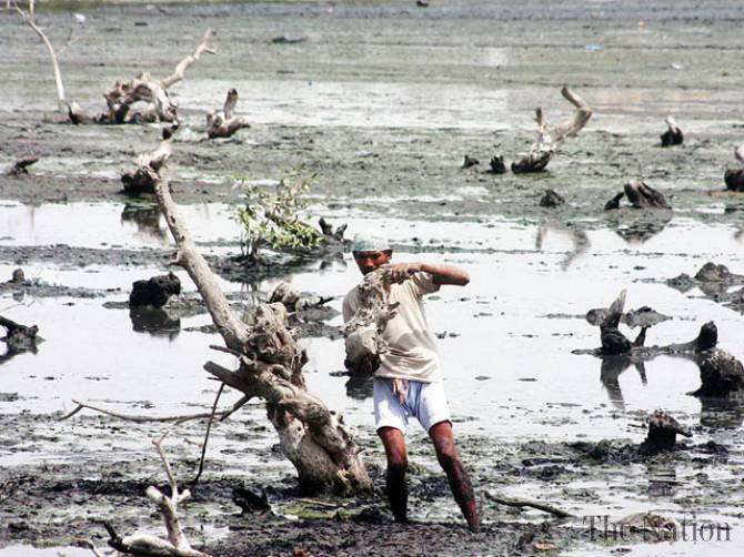


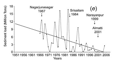
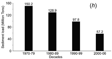
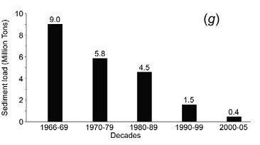
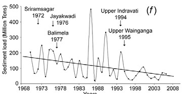

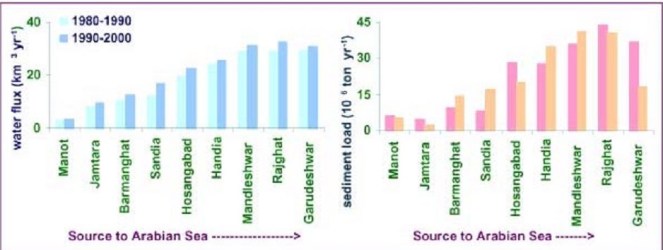
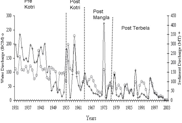
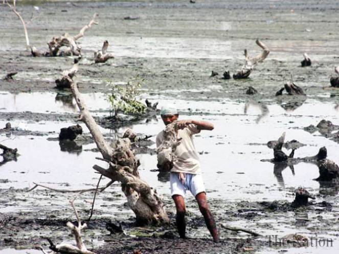
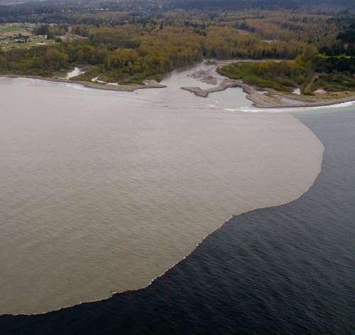
 One of the two lead coordinating authors of this report was Dr. Arun Kumar, from AHEC, IIT Roorkee. Notably, Dr. Kumar was also a part of the team which worked on Cumulative Impact Assessment of Hydropower projects in Upper Ganga basin of Uttarakhand