Dams

Guesstimating a Future: Questioning Knowledge Formation, Expertise and ‘development’ in Post Independence India            

-Ramya Swayamprakash (ramya.swayamprakash@gmail.com)

Large dams represent a gamut of ideas around the asocial and apolitical nature of water itself, i.e., ‘modern water’[1], expert control, and national space that are stitched together to yield hydraulic bureaucracies or hydrocracies. In the 20th century, the ‘hydraulic mission’ (See Molle et all 2009) was accepted across the globe and entrusted with hydrocracies which became synonymous with the project of ‘development’. These hydrocracies have left an indelible mark on national economies and geographies, constructing massive damming projects i.e. what India’s first Prime Minister called ‘temple[s] of modern India’. The effects of these projects have been a mixed bag. In India, these ideas about water and technology formed a template through which the hydrocracy—which took the form of the Central Water Commission (CWC)— conceived, discussed, and justified technological interventions. Rivers were described as natural features without history, ecology, and society, making a case for greater technological control.

Santhal TRibal Lady budhni-inaugurating-the-power-station-at-the-panchet-dam-in-december-1959-photo-nehru-memorial-museum-and-library-new-delhi.jpg Photo from: The Hindu
Santhal Tribal Lady Budhni inaugurating the power station at the Panchet dam in December 1959 photo Nehru memorial museum and library New Delhi Photo from: The Hindu

Using engineering voices from the Indian Journal of Power and River Valley Development (IJPRVD) and Government of India publications, I attempt to puncture the ‘tunnel vision’ of hydraulic development in India. Juxtaposing two contrasting narratives within the engineering community, the attempt is simply to bring out the spirited debate on large dams in post independence India- a fact lost in the din about which narrative won.

Except one engineer, M.Karantha who was the Chief Electrical Inspector of the erstwhile Madras Presidency, all the other engineers quoted in this post viz. A.Khosla, K.L. Vij, S.N.Gupta, Kanwar Sain etc were a part of the Central Water & Power Commission (CW&PC) before it became the Central Water Commission (CWC).[2]

Transforming Rivers into datasets Hydraulic manipulation has a long history in the Indian subcontinent. Hydraulic engineers in the 20th century recast modern irrigation as the logical conclusion of millennia long hydraulic manipulation practices- projecting irrigation, specifically dams and canals, as age-old components of the riverine landscape thus establishing continuity with the ‘unbroken’ tradition of hydraulic manipulation. This projection was selective: it did not acknowledge the colonial state’s role in establishing a radical break in hydraulic principle in the subcontinent by introducing perennial irrigation; barrages and weirs that effectively flattened a river’s variable flow. Instead, independence was projected as the watershed moment at which the millennia long project of hydraulic manipulation would reach fruition in the form of large dam projects.

Interestingly, engineers saw colonialism as helping bring modern science and technology to India; colonialism’s only limitation was ‘that it constituted an insult in that it denied that Indians could fully be partners in the enterprise of modernity’ (Klingensmith 2007: 233). Modernity in their eyes was an inevitable process, denied to India pre-independence. Modern science was a universal, emancipating category. According to S.N. Gupta: ‘[S]cientific, engineering and industrial research directed towards greater understanding and greater control of material surroundings is the keynote of the modern search for progress and power’ (Gupta 1970:3).  The unfinished business of modernity, thus, was the complete control of nature, which could only be realized through the nation-state.

A villager wondering if his village will be submerged under Hirakud Dam. Photo: Biswaksen Bohidar from: http://sadharanapurusha-karunakar.blogspot.in/

A System of Limits and Solutions One of the foremost challenges facing post independent India was food security. Narratives for water control underscore this challenge. There were carefully worded alarms about scarcity and impending catastrophe. Such warnings are found with striking regularity in the IJPRVDand the Silver Jubilee Souvenir of the CW&PC. For instance, S.N. Gupta asserted:

[T]he fateful year 1947- the year of India’s independence brought both responsibilities and opportunities. The country was faced with the basic question: Adequate production of food for the growing millions (S.N. Gupta 1970: 1).

The only way to meet this ever-increasing demand was to increase the area under cultivation by providing more water: The food production has to keep pace with the ever increasing requirements of population. The principal remedy for meeting this increased demand is to steadily extend irrigation facilities (Kanwar Sain 1959: 37a).

The answer was simply put: greater investment in developing water resources to ensure that the twin challenges of a rising population and looming food scarcity could be met effectively. Technology would provide solutions to tame nature for human needs.

There are two equally important elements in human progress. They are the development of spirit and character on the one hand, and the mastery of the physical world on the other… Without mastery over nature, our earth, as it stands would support but a small fraction of the present population… I submit that hunger and poverty are no longer beyond solution. The mastery over the physical world gives us the key to the problem. The most thickly populated regions on earth can be satisfactorily fed if the most effective known methods are applied. The technical possibilities of feeding the world will probably always run far ahead of the increase in population (Kanwar Sain 1957:1).This neo-Malthusian trap anticipated more than just technological problems and solutions. The rhetoric about looming scarcity and overpopulation served as a vantage point to drive home arguments for large multipurpose projects. This was an unprecedented move by Indian engineers in conceptualizing Indian rivers. Modeled on the TVA (Tennessee Valley Authority), these projects would render rivers into a ledger of flows and returns. As a complete system of inter-related projects, the aim was to ensure rivers would no longer ‘run waste to the sea’ (Khosla 1951:2). Basin-wide development therefore came to be premised on the scarcity trap. These visions of scarcity were axiomatic in two ways:

1)                  The ability of science and engineers to forewarn such a possibility due to the exact nature of their science and scientific method.

2)                  The need for planned development to ensure that fragile and unreliable natural resources could be yielded into reliable flows to provide consistent maximum returns.

Without large multi-purpose dam projects to control floods, manufacture electricity, provide water for irrigation, and utilize an ‘inexhaustible source of water supply in the form of rainfall’, all that water would go to waste (Khosla 1970a: 15). These projects would meet the pressing needs of the country:

[K]eeping in view the need of the country, priority has been accorded to projects likely to yield additional food at an early date. Large multi-purpose projects have been phased with a view to an early completion of their irrigation aspect (Dhir 1959: 57).

Indeed, as K.L. Vij stated while commenting on hydro-electric resources in India emphatically:

[E]ssentially the problem is simple, in that it resolves itself into an examination of the possibilities of utilizing “available water supplies” at the maximum possible head (Vij 1959: 64).

It was only through such a thorough examination of hydraulic heads that entire river basins could function as measures of water resources. As stocks of volumes, rivers held enormous possibilities, provided they were engineered holistically so as to ensure maximum returns.

dr-ho-chi-minh-president-of-the-democratic-republic-of-vietnam-and-other-party-members-photographed-at-the-dam-site-during-his-visit-to-bhakra-dam-on-february-8-195
Dr Ho-Chi-Minh, president of the Democratic Republic of Vietnam and other party members photographed at the dam site during his visit to Bhakra dam on February 8 1958 Photo: photodivison.gov.in

Burgeoning Bureaucracy It’s [sic] (the CW&PC’s) development and march towards organizational expansion has been linked up with the development and planning of projects in the country since Independence and thus the stature of the Commission today is a barometer of the progress achieved by the country in the fields of irrigation and power (Jain 1970a: 21).

Kanwar Sain summed up the times emphatically: ‘[K]ey to the production of wealth is the Kilowatt. Underlying the country’s capacity to produce anything else is our capacity to produce power’ (Sain 1959: 37b. Emphasis added). There is a clear imperative to scale up through expert-led interventions. According to H.S. Desai,

[V]iewed purely from technical angle, and given all the goodwill that such cases deserve other angles, it is felt that engineers could and should have the last word on the development of the water resources of the country (Desai and Rao, 1970: 82).

Development, it might seem, could best achieved if driven by expert-led organizations like CW&PC. This championing of a burgeoning hydrocracy helped incubate and insulate it from overt political and social questions.

Holistic Planning for Basin-wide Development Planning water resource development required rearranging rivers into basin-units instead of geographies or people. Rivers as basin-units, like the larger nation state were comparable and amenable to technological solutions for resource optimization, and wired apolitically. Sain clearly charted out a course for the same:

[T]o make effective use of waters for irrigation, navigation, power and other allied purposes, it is necessary that a careful and unified development of the whole basin is planned irrespective of that number of States or Provincial boundaries that may be involved. It is only in this manner that optimum utilization of resources of the entire water-shed can be made and waste of any potential resources of the valley eliminated. If the entire basin is not developed as a unit there is the possibility of confusion arising when each State starts controlling the river from its own point of view (Sain 1959: 37b-c).

Some of the many voices include those of M.L. Sood, A.N. Khosla and S.K. Jain:

Practically all the river systems of the country run through more than one State. Their balanced development in the interest of navigation and other objects, e.g., irrigation, hydro-electric power and flood control, demands that the entire valley is treated as one unit irrespective of State boundaries (Sood 1959:52).

Modern technology for conservation and utilization of water resources is making rapid strides. With a unified and integrated approach to the development and utilization of surface and ground waters and to problems of agriculture and irrigation, this challenge (of looming resource crunch and a steady population rise) can be met (Khosla 1970a: 14).

It has been well recognized that river basin should be considered a single unit for development of water resources (Jain, 1970:12).

A basin-based approach across rivers was thus, the most efficient means to develop the nation’s water resources: ‘[T]he water and power resources of a region, basin and sub-basin and the transfer and interchange of both water and power between regions, basins and sub-basins in the overall interest of the country and regions concerned’(Khosla 1970a:12). These arguments combined to form the basis for a National Water Grid — an idea first proposed by Sir Arthur Cotton in the 19th century. Post Independence, the grid was seen as a means to ensure that the excesses of one river basin could replenish the deficiencies of another:

Large areas in Western, Central and Southern India have a very low rainfall while in the Northern and Eastern regions heavy monsoon rains cause extensive floods and large volumes of water flow waste to the sea. The National Water Grid has been conceived for remedying this imbalance to a certain extent by transferring waters from surplus regions to deficit areas by interlinking the various river basins so that transfer of water becomes possible (Rao 1979:104).

Rivers, thus, came to be re-conceptualized as units that could be rationally developed for maximum usage through multi-purpose projects. The natural world came to be arranged as a system of excesses and deficits that could be corrected with mathematical precision to yield steady, uniform returns. To the post-independence engineering mind, the National Water Grid was not a possibility but a certainty; the question was when it would become reality & not if it is desirable, viable or acceptable:

[T]hese policies will have to be implemented sooner or later for the survival and prosperity of our country (Rao 1979:100).

Driven by a burgeoning hydrocracy, the National Water Grid would render the riverine landscape entirely legible and amenable to complete development as well as provide impetus to power sector development, with reliable flows for hydropower generation. Tapped from source to mouth, river would cease to flow freely or at all. Instead, they would populate man made lakes; the tail of one reservoir would be the beginning of another hydro-project.

Rivers were thus reified and reconceptualized as prospective models that could be reproducible; a function of heads and cusecs. The development apparatus thus acquired ‘the character of calculability’ (Mitchell 2002:92) that mediated between material realities and the abstractions of science and politics. Numerical indicators came to speak for themselves and became tangible enough to mold facts. Rivers came to be organized in a linear fashion, as reproducible units across landscapes that were framed and solved technologically.

Marking the Elisions Despite their self-assuredness, these claims faced doubts, criticisms, opposition and questions. Engineers’ own admissions about the nature of hydrology are telling:

When the position regarding the resources of the country began to be reconsidered after the attainment of Independence in August 1947, it became apparent that there was very little data to enable an accurate estimate of the power potential to the country. Even selection of schemes for immediate detailed investigations had to be done on an ‘ad hoc’ basis (Vij 1959:64; emphasis original).

Indeed, according to the Five Member Review of the Sardar Sarovar Project by Patil et al, the CWC itself admitted:

Hydrology as a discipline is different from most of the engineering disciplines. Natural phenomena, with which hydrology is concerned, though have underlying physical processes, are complex and not amenable, to deterministic approach: They do not lend themselves to rigorous analysis not offer unique solutions as are possible in engineering mechanics [sic]. Since water resource development activity cannot be delayed for want of data of adequate quality and quantity, best judgement has to be resorted to. In the field of hydrology one has to devise methods to suit the data available and come out with solutions. Accepting a solution in turn needs judgement with due consideration to sociological, economic and political situations (Patil et al, 1994:7; emphasis added, see: www.ielrc.org/content/c9402.pdf).

Development plans preceded data, in lieu of which, projections and assumptions would have to do. Until 1958, when the erstwhile Ministry of Irrigation and Power (now the Ministry of Water Resources) set up a number of gauge and discharge observation stations on the Ganges and its tributaries to assess the flow, plans for river development were based on A.N. Khosla’s pioneering formula to calculate stream flows based on certain assumptions.

Voices of dissent constantly called for a more reflexive, inclusive, and engaged process of development. M.V. Karantha, the Chief Electrical Inspector of the erstwhile Madras Presidency was an early critic. In his article in the March 1952 issue of IJPRVD, he charged that his colleagues built for themselves and for Western observers rather than for India’s villagers. He observed that in India, like in other parts of Asia, ‘it has been the small tail of urban population that has been waging the body, the rural population’ (Karantha 1952: 11). In order to realise the true embodiments of democracy, he asked engineers to realise that engineers should utilise their education and training ‘not only for own self-advancement but also for the benefit of the common man if democracy is to be real and to survive’. According to Karantha, the common man is the single most important denominator for gauging the efficacy of engineering processes and technology. He said,

[I]f we Indian Engineers are to  be praised for what we have done and what we are going to do for our country, obviously the praise has to be for what we have done and what we are going to do for these majority people, the common man (Karantha 1952:11).

Karantha championed the need for local solutions because, ‘[O]ur economic and industrial problems are peculiarly our own’ (Karantha 1952:16). He was particularly critical of western models that were prescriptively and sometimes uncritically imported to India:

[O]nly if we realise that in the field of technology the problem of India is indeed very different from that of the Western countries whose practice we have been blindly adopting. Ours is a country in which the population has now grown beyond any easily manageable limit. Even our annual increase of population is as much as that of the entire population of some of the smaller nations of Europe. Our resources though not bad are like the property of a middle class man which has got to be divided amongst his dozen children. There is too little to go around to all to enable us to act as if we are engineers living in America. We have no great outside markets for manufactured good from which we can enrich ourselves for us to act as if we were the rich British or Swiss engineers. It will be a tremendous task to increase our prosperity yearly even to the extent our population is increasing yearly. It is exceedingly stupid and suicidal for a poor man to imitate a rich man. For a similar reason, it is suicidal for us to imitate our poor country the methods which the rich and prosperous Western countries have adopted. We have no tangible proof whatsoever that we can ever catch up with them for very many decades to come (Karantha 1952: 18).

Karantha was extremely anxious about a centralized bureaucracy:

It seems to be that there is often, for people in our country, a fascination for collecting more power for themselves and to believe that others can never be trusted to do things so efficiently. But more the centralization the less the touch with local conditions which alone are capable of being turned to advantage by way of cheapness and quickness of action, so essential for our country. Engineers sitting far away do not find it easy to tackle endless local problem of varied types. So they insist on standardization, however costly it be. They have also better chances of salaries and promotion, the more the services are centralised. But it is the common man that finally pays for all the costliness, delays and misunderstanding of local problems. Nor is over-centralisation the way to train our people in democracy (Karantha 1952: 20).

In a more focused critique, engineer Ram Kishore examined the financial aspects of irrigation works, asking questions of transparency, efficiency etc. He remarked that:

A large number of irrigation works and other development projects are under consideration, investigation or construction in India. Some of them have been completed. Figures of actual cost in the case of completed projects, and of estimated cost in the case of other projects are usually available with ease, through often very late; but figures of anticipated net profits and other figures for the comparison of different projects are usually not available to the public. They are worked out in Government offices but are not usually published, apparently in order to avoid or reduce criticism.

All estimates and forecasts are in their very nature approximate and liable to prove more or less wrong, or incorrect when the project has been built and developed, more specially when the time of construction and development is long. We all make estimates and forecasts, and it is very important to do so, even if they prove a hundred percent out in the end; only we should try and make our estimates as correct as possible, and also invite suggestions and criticism. All printed literature about Government Projects should be made available to the public, sufficiently in advance of their being sanctioned so that non-government engineers, and others can offer suitable criticism. This is very important in a democratic country, even though it will to some extent increase work in Government offices. It will most probably do a great deal of good. In the absence of correct information criticism, where made, is usually based on wrong information and does more harm than good (Kishore 1952: 29-30).

At first glance, it might have seemed that the development process in post independence India was undeterred. In questioning the centralizing tendencies of the bureaucracy and calling for greater transparency and locality in the planning process, these brief but powerful early critiques point to the frictions in development. Without remarking on which side and why, these critiques offer a radical puncturing to the ‘tunnel vision’ of hydraulic engineers. As a critique coming from within the engineering community itself, they point to the fact that maybe development did not have as much of a buy in as the early heady narratives might have had us believe.

These couple of critical voices cited above were not the only critical voices present in those initial years after independence, there were many others. But these are given here as examples to point out that there were voices even from within engineering fraternity that were pointing that alternative development paths were available, and that the path taken was not the only option available to the society. In fact even Pandit Jawaharlal Nehru, in his speech before the annual meeting of CBIP in November 1958, talked about disease of gigantism plaguing Indian dam establishment (see page 6 of June 2006 issue of “Dams, Rivers & People”, see: https://sandrp.in/drp/June2006.pdf).

Why did Nehru not change the course after that speech is another question. The non-accountable culture that water engineering clan was allowed to indulge in is continuing to damage to this day. But that is another story.

Works cited:

Agnew, John. “The Territorial Trap: The Geographical Assumptions of International Relations Theory.” Review of International Political Economy 1, No. 1 (1994): 53–80.

Dams, Rivers & People, June 2006, p 6 (https://sandrp.in/drp/June2006.pdf)

Dhir, R.D. “Utilisation of Water Resources India.” Indian Journal of Power and River Valley Development 2, No. 6 (May 1952): 1-8.

—. “Water Resource Utilisation in India: A Brief Review.” Indian Journal of Power and River Valley Development 9, Numbers 6 & 7 (June- July 1959, CW&PC Special Number): 49-51.

Gupta, S.N. “Challenges of Seventies, Eighties ….and Central Water & Power Commission.” In Central Water & Power Commission (CWPC) Silver Jubilee Souvenir. New Delhi: Ministry of Irrigation and Power, Government of India, 1970.

—. “Challenges of Seventies, Eighties, And Central Water & Power Commission.” In Central Water & Power Commission (CWPC) Silver Jubilee Souvenir, 1-3. New Delhi: Ministry of Irrigation and Power, Government of India, 1970.

Hayath, M. “Power Development in India.” Indian Journal of Power and River Valley Development 9, Numbers  6&7 (June-July 1959, CW&PC Special Number): 39-39i.

Jain, S.K. “25 Years of CWPC- A Historical Review.” In Central Water & Power Commission (CWPC) Silver Jubilee Souvenir, 18-22. New Delhi: Ministry of Irrigation and Power, Government of India, 1970a.

—. “Problems in Irrigation Development in India.” In Central Water & Power Commission (CWPC) Silver Jubilee Souvenir, 180-183. New Delhi: Ministry of Irrigation and Power, Government of India, 1970b.

Karantha, M.V. “The Engineer and the Country.” Indian Journal of Power and River Valley Development 3, No. 4 ( March 1952): 11-22.

Khosla, Ajudhiya Nath. “Central Water and Power Commission: April 1945 to April 1970.” In Central Water & Power Commission (CWPC) Silver Jubilee Souvenir, 10-17. New Delhi: Ministry of Irrigation and Power, Government of India, 1970a.

—.“My Reminiscenes of The Central Water Commission.” 20, No. 3 (March 1970b, CW&PC Special Number): 107-111.

—. “Our Plans.” Indian Journal of Power and River Valley Development 1, No. 7 (1951): 1-4.

Kishore, Ram, “Financial Aspects of Irrigation Works,” Indian Journal of Power and River Valley Development 2, No. 5(April 1952), 29-30.

Klingensmith, Daniel. One Valley and a Thousand: Dams, Development and Nationalism. New Delhi: Oxford University Press, 2007.

Linton, Jamie. What is Water: The History of a Modern Abstraction. Vancouver, Toronto: University of British Columbia Press, 2010.

Molle, François, Peter P Mollinga, and Philippus Wester. “Hydraulic bureaucracies and the hydraulic mission: Flows of water, flows of power.” Water Alternatives 2, No. 3 (2009): 328‐349.

Patil, J., Vasant Gowarikar, Ramaswamy R Iyer, L. C. Jain, and V. C.Kulandaiswamy. “Report of the Five Member Group Set Up by the Ministry of Water Resources to Discuss Various Issues Relating to the Sardar Sarovar Project.” New Delhi, 21 April 1994.

Rao, Dr. K.L. Cusecs Candidate: Memoirs of an Engineer. New Delhi: Metropolitan Press, 1979.

Rao, G.V., and H.S. Desai. “Role of CW&PC in development of inter-state rivers.” In Central Water & Power Commission (CWPC) Silver Jubilee Souvenir, 80-82. New Delhi: Ministry of Irrigation and Power, Government of India, 1970.

Reisner, Marc. Cadillac Desert: The American West and its Disappearing Water. New York: Penguin, 1986.

Sain, Kanwar. “Administrative Organisations for Water Development Projects and Inter-State Rivers in India.” In Central Water & Power Commission (CWPC) Silver Jubilee Souvenir, 166-171. New Delhi: Ministry of Irrigaiton and Power, Government of India, 1970.

—. “Developing India’s Water and Power Resources.” Indian Journal of Power and River Valley Development 9, Numbers 6 & 7 (June-July 1959, CW&PC Special Number): 37-37b &37c.

—. “The Engineer in the Developing Community.” Indian Journal of Power and River Valley Development 7, No. 3 (March 1957): 1-7.

Scott, James. “High Modernist Social Engineering: The Case of the Tennessee Valley Authority.” In Experiencing the State, by Lloyd I Rudolph and John Kurt Jacobsen, 2006. New Delhi: Oxford University Press, 3-52.

Sood, M.L. “Inland Navigation in India.” Indian Journal of Power and River Valley Development 9, Nos. 6&7 (June-July 1959, CW&PC Special Number): 45-48 & 52.

Thakkar, Himanshu “Who takes decisions for large Dams? How? Why? Who profits? Who pays? Many questions, few answers” South Asia Network on Dams, Rivers & People, October 2005 (https://sandrp.in/dams/Pol_economy_dams.pdf)

Vij, K.L. “India’s Hydro-Electric Resources and Their Assessment.” Indian Journal of Power and River Valley Development 9, Numbers 6&7 (June-July 1959, CW&PC Special Number): 63-67.

END NOTES:

[1] Jamie Linton contends that the ‘modern idea of water as an objective, homogenous, ahistorical entity is complimented by its physical containment and isolation from people and reinforced by modern techniques of management that have enabled many of us to survive without having to think much about it’. He states that the twin processes of the formulation of water as a chemical formula, i.e. H2O and the development and dissemination of the concept of the hydrologic cycle represent an important contribution to the idea of abstract, modern water. In a philosophical investigation elaborating the fundamental incompatibility of modern water with people, Linton argues that despite being produced in relation to social practice, modern water is nevertheless taken to be entirely independent of social relations. Borrowing from Bruno Latour and Actor Network Theory, he claims that the ‘fictional’ independence of water from society is at the core of the ‘constitution of modern water’. This constitution of modern water holds together ‘only so long as the appearance can be sustained in hydrological and popular discourse’. See Jamie Linton, What is Water? A History of a Modern Abstraction (Kingston and Toronto: University of British Columbia Press 2010, p. 21and 175).

[2] The Central Water & Power Commission (CW&PC) was reconstituted as the Central Water Commission in 1974 & Central Electricity Authority. The CW&PC itself had a long gestation period and was a combination of a bunch of institutions that dealt with inland navigation, power generation, and hydraulic engineering.

[3] To read the story of Budhni Mejhan, see: http://www.thehindu.com/todays-paper/tp-opinion/recovering-budhni-mejhan-from-the-silted-landscape-of-modern-india/article3481766.ece

Dams

Good, bad and ugly – YJA ‘green’ take on the Union Budget 2014-15

Manoj Misra, YAMUNA JIYE ABHIYAAN (yamunajiye@gmail.com)

Here is OUR TAKE ON VARIOUS PROVISIONS IN THE UNION BUDGET for 2014-15 presented by Union Finance Minister of Government of India in Parliament on July 10, 2014. This is focused on provisions related to Urban Sector. In what followed, I have given the relevant  para from the budget speech, followed by my comment in italics

Smart Cities

24.       As the fruits of development reach an increasingly large number of people, the pace of migration from the rural areas to the cities is increasing. A neo middle class is emerging which has the aspiration of better living standards. Unless, new cities are developed to accommodate the burgeoning number of people, the existing cities would soon become unlivable. The Prime Minister has a vision of developing ‘one hundred Smart Cities’, as satellite towns of larger cities and by modernizing the existing mid-sized cities. To provide the necessary focus to this critical activity, I have provided a sum of `7,060 crore in the current fiscal.

Building ‘Smart Cities’ is a welcome idea provided the definition of “smart” includes zero pollution discharge; incorporation of eco-sanitation (zero sewage) and ensuring the integrity of existing water bodies as central to planning of such new cities.

Skill India

28. A national multi-skill programme called Skill India is proposed to be launched. It would skill the youth with an emphasis on employability and entrepreneur skills. It will also provide training and support for traditional professions like welders, carpenters, cobblers, masons, blacksmiths, weavers etc. Convergence of various schemes to attain this objective is also proposed.

Skill generation activity must not be in isolation as merely targeted at employability and consequent outmigration to urban / overseas centres. It must be part of a larger aim of re-establishment of village republics where skilled youth have round the year opportunities of gainful work including returns on barter basis. 

PradhanMantriKrishiSinchayeeYojana

29.       Bulk of our farm lands are rain fed and dependent on monsoons. Therefore, there is a need to provide assured irrigation to mitigate risk. To improve access to irrigation we propose to initiate the scheme “PradhanMantriKrishiSinchayeeYojana”. I propose to set aside a sum of `1,000 crore for this purpose.

We hope that this scheme actually results in restoration of village ponds, village level micro-irrigation facilities and wells in each farm.

Swatchh Bharat Abhiyan

30. The need for sanitation is of utmost importance. Although the Central Government is providing resources within its means, the task of total sanitation cannot be achieved without the support of all. The Government intends to cover every household by total sanitation by the year 2019, the 150th year of the Birth anniversary of Mahatma Gandhi through Swatchh Bharat Abhiyan.

This should focus on promotion of dry toilets and eco-sanitation.

Statue of Unity

33. Government of Gujarat has embarked upon the mission to build the largest statue of SardarVallabhBhai Patel. Sardar Patel stands as the symbol of the unity of the country. To support the Gujarat Government in this initiative to erect the Statue of Unity, I propose to set aside a sum of `200 crore.

We are sure that Sardar Patel would have never approved of such a wasteful expenditure. You do not need a statue to highlight either the greatness of an individual or to establish national unity. This must be reconsidered and dropped.  

Watershed Development

50. To give an added impetus to watershed development in the country, I propose to start a new programme called “Neeranchal” with an initial outlay of `2,142 crores in the current financial year.

Most welcome. We hope that this becomes a people’s movement.

Urban Renewal

66.   It is time that our cities and towns undergo urban renewal and become better places to live in. While developing housing and other infrastructure, both physical and economic, which can have local variations, four fundamental activities must underpin such development. These are provision of safe drinking water and sewerage management, use of recycled water for growing organic fruits and vegetable, solid waste management and digital connectivity. It is the vision of this Government that at least five hundred (500) such habitations must be provided support, while harnessing private capital and expertise through PPPs, to renew their infrastructure and services in the next ten years.

This is welcome with a caveat. It should not become an excuse for privatisation of water management in these habitations.

Climate change is a reality which all of us have to face together. Agriculture as an activity is most prone to the vagaries of climate change. To meet this challenge, I propose to establish a “National Adaptation Fund” for climate change. As an initial sum an amount of `100 crore will be transferred to the Fund.

Good and timely move.

Inland Navigation

112.     Development of inland waterways can improve vastly the capacity for the transportation of goods. A project on the river Ganga called ‘JalMargVikas’ (National Waterways-I) will be developed between Allahabad and Haldia to cover a distance of 1620 kms, which will enable commercial navigation of at least 1500 tonne vessels. The project will be completed over a period of six years at an estimated cost of `4,200 crore.

We fail to appreciate the urgency of this action since a national road map for a rejuvenated Ganga is still to be devised and any such move unless it finds a good fit (most unlikely) in that road map would result in further degradation, pollution, compromising the integrity of whatever Ganga today exists downstream of Allahabad. This must be deferred till a fully participatory, transparent and merit based Ganga rejuvenation plan has been put in place.    

Water Resources and cleaning of Ganga

Linking of Rivers

153.     Rivers form the lifeline of our country. They provide water not only for producing food for the multitudes but also drinking water. Unfortunately the country is not uniformly blessed with perennial rivers. Therefore, an effort to link the rivers can give rich dividends to the country. It is time that we made a serious effort to move in this direction. To expedite the preparation of the Detailed Project Reports, I propose to set aside a sum of `100 crore.

Yes, rivers are our life lines. But these are living ecological entities and product of millions of years of geo-morphological processes and NOT some pipelines carrying water which could be redirected and tampered with at will. India is blessed with diversity of land forms, biomes and biodiversity that has evolved over the millennia. And it cannot be anyone’s case that all parts of India should have perennial rivers? Such presumptions are bad in science and against nature where diversity and NOT uniformity is the law. We sincerely hope that such unscientific, unethical and unnatural obsessions are laid to rest once and for all times.

Sacred Rivers

154.     Substantial amount of money has been spent in the conservation and improvement of the Ganga, which has a very special sacred place in the collective consciousness of this country. However, the efforts have not yielded desired results because of the lack of concerted effort by all the stakeholders. I propose to set up Integrated Ganga Conservation Mission called “NamamiGange” and set aside a sum of `2,037 crores for this purpose.

We wholeheartedly endorse the realisation of past failures and this move on IGCM and the name – Namami Gange! But hopefully the planners also understand that we cannot remain respectful (namami) to Ganga (Maa) and yet disregard its integrity as an ecological system by interfering at will with it, in the name of either river linking or building dams and barrages on it?????    

Development of Ghats and beautification of Riverfront

155.     Our Riverfronts and Ghats are not only places of rich historical heritage but many of these are also sacred. To start this process in the country, I propose to set aside a sum of `100 crore for Ghat development and beautification of river front at Kedarnath, Haridwar, Kanpur, Varanasi, Allahabad, Patna and Delhi in the current financial year.

Ghat and river front at Kedarnath? Obviously the Hon’ble FM is still to visit Kedarnath……

NRI Ganga Fund

156.     NRIs have been a very important contributor to the development process in India, in areas such as education, health and preservation of culture. In this context, to harness their enthusiasm to contribute towards the conservation of the river Ganga, NRI Fund for Ganga will be set up which will finance special projects.

This is a welcome step. We only hope that special projects are ecological and not infrastructural or commercial in nature?

Conservation of Himalayas

171.     There is a great need to increase the capacity in the country for Himalayan Studies. I propose to set up a National Centre for Himalayan Studies in Uttarakhand with an initial outlay of `100 crore.
This is a welcome and much delayed move.

National Capital Territory of Delhi

178.    In addition, to solve the long term water supply issues to the capital region, construction of long pending Renuka Dam would be taken up on priority. I have provided an initial sum of `50 crore for this.

This is again a totally unnecessary investment in the name of a city that is perhaps globally the most water provided in its class. The money should be rather used to improve water management including demand management in the city of Delhi. 

10 July 2014

RELATED LINKS:

[1] https://sandrp.wordpress.com/2014/07/10/rivers-and-water-in-union-budget-2014-15/

Delhi · Ganga · Interlinking of RIvers

Rivers and Water in Union Budget 2014-15

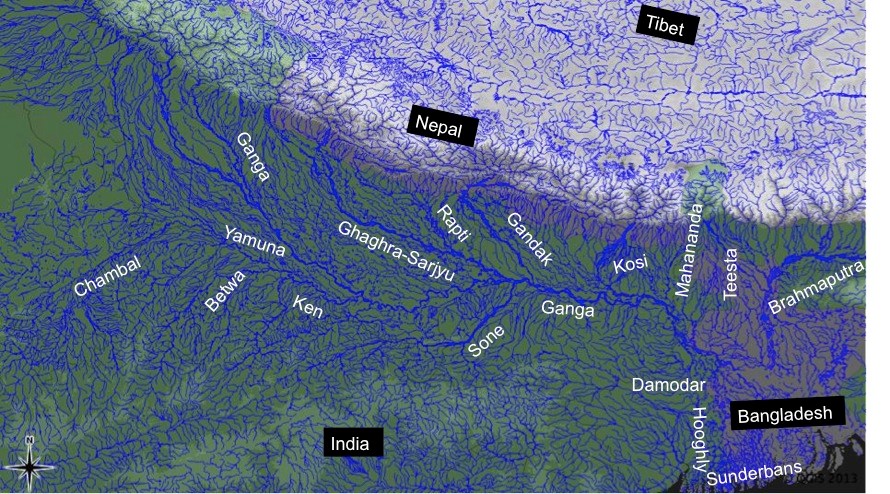
In the first annual budget (for the year 2014-15) presented by the new NDA government at the centre on July 10, 2014, it is generally bad news for Ganga and other rivers. Below we have given various provisions on water and river from the budget speech of the Finance Minister Shri Arun Jaitley. Mr Jaitley said in his speech: “In the first Budget of this NDA government that I am presenting before the august House, my aim is to lay down a broad policy indicator of the direction in which we wish to take this country.” The broad policy indicators on rivers do not seem to be any good news for the rivers of the country.

RIVERS FM said, “Rivers form the lifeline of our country. They provide water not only for producing food for the multitudes but also drinking water.” This shows the limited understanding of rivers that the government has. Rivers provides so much more than water. The FM do not seem to have any good news for this lifeline as the budget has several proposals that will harm and destroy the rivers.

River Linking The PIB wrongly claims, “The Budget also contains the first ever effort to link the rivers across the country.” A sum of Rs. 100 crore in the current Budget to expedite the preparation of Detailed Project Reports has been set aside. This is waste of public money. In addition to this, there is a huge allocation for the annual budget for NWDA, whose only mandate is studies for river linking. It is existing for 22 years, but has not produced a single document that will pass independent public scrutiny, and NWDA is afraid to put any document in public domain. Why is the government spending money on such fruitless exercise?

GANGA: Integrated Ganga Conservation Mission The Finance Minister, Shri Arun Jaitley said, “I propose to set up Integrated Ganga Conservation Mission called “Namami Gange” and set aside a sum of Rs 2,037 crores for this purpose.” Shri Jaitley said that the Mission is being launched because a substantial amount of money has been spent in the conservation and improvement of the river Ganga but the efforts have not yielded desired results because of the lack of concerted effort by all the stakeholders. This is admission of even NDA’s failure, since they were in power for at least six years and have not been able to make a dent in the state of the river. They should learn from that experience before jumping into such missions.

This raises a lot of unanswered questions: There is already an existing National Mission for Clean Ganga and if this new mission will be in addition to the old one or if the old one will be abolished? What is new in the new mission? Strangely, the FM did not use the work Ganga Rejuvenation, the charge that Ms Uma Bharti has been given. Does this indicate something is amiss here?

Riverfront Development “The Finance Minister has also set aside a sum of Rs. 100 crore for Ghat development and beautification of river front at Kedarnath, Haridwar, Kanpur, Varanasi, Allahabad, Patna and Delhi in the current financial year since Riverfronts and Ghats are not only places of rich historical heritage but many of these are also sacred.”

The trouble is, this could spell disaster for the river and the cities where such development is planned, if this is going to happen on the lines of Sabarmati river front development. This is because in case of Sabarmati, the Riverfront development meant encroachment of over 200 ha of riverbed. If this is followed the river’s carrying capacity will be reduced. In changing climate, rivers need more and not less carrying capacity as the events of July 2005 in Mumbai, of August 2006 in Surat & recent years in Delhi have indicated. During Uttarakhand disaster of June 2013 the buildings that we saw collapsing were all standing on the riverbeds. That should be a warning for any riverfront development that would encroach on the riverbed.

NRI Fund for Ganga To harness the enthusiasm of the NRI Community to contribute towards the conservation of the river Ganga, an NRI Fund for Ganga will be set up which will finance special projects, the Finance Minister added.

“A project on the river Ganga called ‘Jal Marg Vikas’ (National Waterways-I) will be developed between Allahabad and Haldia to cover a distance of 1620 kms, which will enable commercial navigation of at least 1500 tonne vessels. The project will be completed over a period of six years at an estimated cost of Rs 4,200 crore.”

Watershed Development To give an added impetus to watershed development in the country, a new programme called “Neeranchal” will be launched with an initial outlay of Rs 2,142 crore in the current financial year. This could be a positive move, but we have to await the details. It is also not clear if this is in addition to the ongoing watershed development or in place of it.

Rural Drinking Water For providing safe drinking water, Rs 3600 crore has been earmarked under National Rural Drinking Water Programme in approximately 20,000 habitations affected with arsenic, fluoride, heavy/toxic elements, pesticides/fertilizers through community water purification plants in next 3 years, the Finance Minister added.

Delhi Water Reforms Rs. 500 crore for water reforms to make Delhi a truly World Class City. The budget does not say a word what these reforms would mean, but going by the track record of this government in past, when they say reforms, they mean privatisation, which will be strongly opposed in Delhi.

Allocation for Renuka has no justification The FM said, “In addition, to solve the long term water supply issues to the capital region, construction of long pending Renuka Dam would be taken up on priority. I have provided an initial sum of Rs 50 crore for this.” Firstly Renuka dam does not even have statutory forest clearance and NGT has stopped work on the project. FM, but allocating money for the project in such a situation has indicated that they do not care for statutory clearance process or judicial orders.

Moreover Delhi does not need any more water from outside. It is already privileged with per capita water availability of over 250 lpcd, which is more than most European cities. Delhi does not harvest rain water, does not use flood water to recharge, does not protect its water bodies, does not treat its sewage, does not recycle and reuse the treated sewage, does not reduce its losses, does not do demand side measures and like a spoilt kid, asks more and more water from long distance sources.

Thirdly, Delhi may want exclusive share in water from Renuka, but Upper Yamuna states of Haryana, UP, Uttarakhand, Rajasthan, Himachal Pradesh and Chandigarh are all asking for their share from the project and are ready to share the costs. Going ahead with the project without resolution of the interstate issues may land us in a soup similar to the Munak Canal.

Allocation for Statue of Unity The budget provides Rs 200 crore for ‘Statue of Unity’ in Gujarat. This project is come up in eco sensitive zone, and will affect large no of people and water body, but it has not seen any social or environmental impact assessment or participatory consultative process. It is supposed to come up in the middle of the water reservoir to be created by the proposed Garudeshwar Dam on Narmada river, but that dam has no impact assessment or clearances and stands challenged in NGT. Allocating money for the project under the circumstances is inappropriate.

Welcome Move: National Centre for Himalayan Studies in Uttarakhand “There is a great need to increase the capacity in the country for Himalayan Studies. I propose to set up a National Centre for Himalayan Studies in Uttarakhand with an initial outlay of Rs 100 crore.”

Irrigation The Budget provides Rs. 1,000 crore for Pradhan Mantri Krishi Seenchaayi Yojana. If this is for decentralized local systems, it would be a welcome move, but no details are available.

Welcome move: Organic farming in North East India Rs 100 crore has been provided in the budget to promote organic farming in Northeast India. This is a welcome move.

Welcome move: National Climate Change Adaptation fund for small farmers The FM said, “Climate change is a reality which all of us have to face together. Agriculture as an activity is most prone to the vagaries of climate change. To meet this challenge, I propose to establish a “National Adaptation Fund” for climate change. As an initial sum an amount of Rs 100 crore will be transferred to the Fund.” This is welcome, but we need to see who corners this money. It should go to the rainfed farmers.

Some other  welcome provisions: Finance to 5 lakh landless farmers through Nabard since landless are not able to get bank loans in absence of land as a guarantee; Rs 50 core set aside for blue revolution for inland fisheries. This is provided there is a move to conserve the riverine fisheries.

On the whole, in spite of some welcome moves, on the whole, the budget brings more bad news for the rivers & those depend on rivers and rains, than good.

SANDRP

Sources:

1. Budget speech of the FM: http://indiabudget.nic.in/ub2014-15/bs/bs.pdf

2. PIB Press Releases from Finance Ministry on July 10, 2014: http://pib.nic.in/newsite/erelease.aspx

Additional issues from Media:

1. The Hindustan Times reported that the budget has reduced the allocation for MEF by 15% compared to previous year: http://www.hindustantimes.com/specials/coverage/unionbudget2014/budget2014/environment-gets-raw-deal-renewable-energy-a-fillip/sp-article10-1238988.aspx

2. The Indian Express has reported that the budget provides additional provisions for shutting downNGOs and Trusts: http://indianexpress.com/article/business/business-others/budget-makes-it-easier-for-govt-to-shut-down-ngos-and-trusts/

3. CSE: “Budget 2014 allocates Rs 200 crore for statue and Rs 50 crore for 50 million people who depend on the handloom sector. What does this say of priorities?”

4. BJP’s maiden budget disappointing for farmers: http://www.downtoearth.org.in/content/bjp-s-maiden-budget-disappointing-farmers

5. ‘Budget silent on crucial farmer suicide issue’: http://timesofindia.indiatimes.com/City/Chandigarh/Budget-silent-on-crucial-farmer-suicide-issue/articleshow/38163502.cms

6. Good, bad and ugly – YJA ‘green’ take on the Union Budget 2014-15: https://sandrp.wordpress.com/2014/07/11/good-bad-and-ugly-our-green-take-on-the-union-budget-2014-15/

Dams

Pauk, Heo, Tato-I Hydropower projects: CISMHE’s shoddy EIAs Seven Big hydro on third order tributary of Brahmaputra!

India is well aware of fury of ‘Mighty Brahmaputra’[i]! The 2900 KM long river is prone to catastrophic flooding in monsoon when the Himalayan snows also melt. It is a classic example of a braided river and is highly susceptible to channel migration and avulsion[ii]. What we seem not to be aware of is the consequences of damming every single tributary at multiple sites in the name of hydro power projects.

Hydro Power projects proposed on Yarjep River
Sr. No. Name of the Project Installed Capacity
1 Pauk HE Project 145 MW
2 Heo HE Project 240 MW
3 Tato-I HE Project 186 MW
4 Rapum HE Project 66 MW
5 Rego HE Project 80 MW
6 Kangtangshiri HE Project 80 MW
7 Pemashelpu HE Project 91 MW
Source: EIA Reports of Pauk, Heo and Tat-I HEP

Consider this: Might Brahmaputra has large number of tributaries, one of them, albeit the main one is Siang river, constituting just 2% of the Brahmaputra basin. Siang has many tributaries, one of them is Siyom River. Siyom has many tributaries, one of them is Yarjep. & now this Yarjep river, third order tributary (when enumeration is done in tree format, starting from main river) of Brahmaputra, is to have seven large hydropower projects with total installed capacity of 888 MW. Three of the largest among these projects together came before the Expert Appraisal Committee of Union Ministry of Environment and Forests for River Valley Projects during their meeting on July 3-4, 2014. All three projects have common developer, namely Velcan Energy[iii] & common EIA (Environment Impact Assessment) consultant, namely Centre for Interdisciplinary Studies of Mountain & Hill Environment  (CISMHE)[iv]. Having been established as a R&D centre by the Power Ministry, there is an issue of conflict of interest since Power Ministry agenda is to push all hydropower projects, but an EIA consultant is supposed to be an independent entity.

L section

The story of river Yarjep in the State of Arunachal Pradesh which is a small part of Brahmaputra River System can help us understand the larger canvas of much ambitions hydro power spree the state is on.

Siang basin Yargyap Basin

Arunachal Pradesh government and the central government plan to make Arunachal Pradesh the ‘future powerhouse’ of the country. Siang basin is considered the largest basin in terms of hydropower potential in Arunachal Pradesh, the present estimated potential is 18293 MW it has over 18000 MW of power potential, which is planned to be harnessed by setting up about 44 hydropower projects spread throughout the basin. Department of Hydro Power Development, Government of Arunachal Pradesh has allotted 39 projects, which are at various stages of survey and investigation. Five projects are yet to be allotted which includes two major projects viz. Siang Upper Stage I (6000 MW) and Siang Upper Stage II (3750 MW), which are in investigation stage.

Such a large-scale development which is expected to take place over a period of next 10-15 years will cause huge environmental impacts and exert tremendous pressure on carrying capacity of Siang basin. Cumulative Impact Assessment and Carrying Capacity Assessment of Siang basin which was conducted by CWC as directed by Inter-Ministerial Group (IMG) in Feb., 2010 on the directions of Prime Minister’s Office (PMO). The study is yet to be approved through a credible participatory process. The study itself has very serious shortcomings[i].

There is an attempt to delink the sanctioning of the individual projects from the CIA & CCA study of the Siang Basin. Even before the report is accepted by MoEF, the ministry is considering three projects proposed in a cascade on Yarjep River of the Siang Basin. Pauk HEP (145 MW), Heo HEP (240 MW) and Tato-I HEP (186 MW), have been proposed as a cascade and were considered for EAC in its 75th meeting held on 3-4th July 2014 for grant of EC (Environment Clearance). EIA studies conducted by Centre for Inter-Disciplinary Studies of Mountain & Hill Environment University of Delhi, Delhi (CISMHE) for all the three projects were submitted to the EAC. Considering these projects is also in clear violation of the MEF order of May 28, 2013 which required that no project beyond the first project be considered in any basin without a cumulative impact study. Siang basin supports spectacular biodiversity as well as anthropological richness in India. Any decision in this basin needs to be taken carefully. Siang CIA CCS Study is a step in that direction which can guide EAC’s decision making regarding Siang Basin projects only after it is completed through a credible process.

All the three EIA reports have serious inadequacies. The EIAs have been conducted in a very project specific manner and do not reflect the cumulative nature of impacts. The EIA reports for the schemes present the respective schemes as Run of the River Schemes (ROR) even when the projects talk of peaking generation and also have large storage of water proposed. The report at several places reflects pro hydro bias. Impact prediction and assessment is highly inadequate and completely bypass the cumulative impacts. The report also shows casual approach towards prediction and mitigation of impacts. SANDRP recently made detailed submissions to EAC after reviewing the EIA reports, EMPs (Environment Management Plan) and Public Hearing reports of the three projects. Highlights of the submissions are given below.

Pro hydro bias Opening chapters of the EIA reports (Apart from Developer’s Foreword, which is inappropriate in an EIA Study) of the EIA begins with ‘Need of hydropower’ and ‘Power potential of Arunachal Pradesh’. This is not expected from an EIA. This does not lay grounds for unbiased impact assessment and supports the project implicitly from word go.

Consultants not aware of policies and Acts Para 1.5.1 the EIA says: “In the course of its development, the Tato-I HEP needs to adhere to all relevant policies and guidelines in general and the following, in particular:

i.) National Forest Policy (NFP), 1988

ii.) National Water Policy (NWP), 2002

iii.) National Rehabilitation and Resettlement Policy (NRRP), 2007

iv.) Rehabilitation and Resettlement Policy (RRP), 2008 of GoAP”.

This shows that the EIA consultants are not even aware of latest policies and Acts. For example, the latest Water Policy is National Water Policy of 2012 and latest R&R Act is that of 2013.

Misleading claim: These are NOT ROR schemes All the three EIA reports keep referring to the projects as ROR schemes. The Executive summary of all the EIA reports starts with a strange statement, “Such (“midsized ROR”) kind of projects is highly environment friendly”, which is clearly wrong and has no place in an EIA. This is not an ROR project, since it also hopes to do peaking power generation. EIA report of Pauk HEP states “2.4.1 One storage capacity in the most upstream project, Pauk, is sufficient to regulate the natural flow during the lean season, and to ensure the diurnal peaking hours of the entire cascade.” While EIA report of Tato-I states that master and slave relationship has been attributed to Heo HEP (master) and Tato-I HEP (slave) due to 94% to 98% direct dependency of Tato-I flows for power generation. The report also states that during peaking power generation for about 3 hours in lean season, ungated trench weir can supplement flows. Pauk HEP has dam with live storage of 1.67 million m3 and Heo HEP has dam with live storage of 0.15 million m3. Dam storage and peaking generation in these cascade projects disqualify them as RoR projects since the projects will be changing the downstream hydrograph, which ROR projects cannot do. The proponent and the EIA consultant are misleading the MoEF as well as investors, statutory bodies and general concerned public that this is an RoR project, thus painting a falsely benign picture of the project.

Hanging bridge

Missing aspects of impact assessment Many of crucial aspect of impact assessment are completely missing.

  • Word ‘Climate Change’ does not feature in EIA report or in the EMP. No assessment of the possible impact of climate change on the project and impact of the project on the local climate as well as increase in green house gas emissions from the reservoir and construction of the project has been done.
  • Similarly impact of the project on adaptation capacity of the local communities in changing climate has not been assessed.
  • Impacts of the dam on the flood character of the river, what will be the changes and how these will impact downstream areas are not assessed.
  • Impacts of changing silt flows downstream from desilting chamber and from silt flushing in monsoon on the downstream areas are not analyzed.
  • Impact on the disaster potential in the project area as well in the downstream due to construction and also operation at various stages, say on landslides, flash floods, etc. is not assessed.
  • Impacts of peaking generation have not been assessed. When a project operates as peaking station, there are severe impacts in the downstream and also upstream (rim stability). These impacts have not been assessed, nor is it assessed how the project will perform in the cascade development it is in.
  • EIA reports of the Heo and Tato-I projects conveniently adopt the site specific seismic study carried out for Pauk HEP by IIT Roorkie stating that “In view of proximity, size of the structure, similarity of lithological/ tectonic features, location in the same geotectonic block, and absence of any major additional tectonic features, it is considered appropriate”.

INADEQUATE IMPACT PREDICTION AND MITIGATION

Impacts on Fishes: The report shows quite a disregard for these migrating species. No mitigation measures for the habitat fragmentation of these species are considered. Schizothorax richardsonaii, Schizothoraicthys prograstus are the two migrating species among the eight species found in the Yarjep river. EMPs for all the projects make no provision for fish ladder or pass stating that the two species can survive in lentic as well lotic waters. The consultant has used only the schizothorax species as an indicator for assessing impact of changes in discharge, depth and velocity. Such assessment based on single species downplays the impact on other species like smaller fish, benthic macro and micro invertebrates which form an important part of the food chain which also supports the target specie. This is also in violation of original TORs.

Playing down fisheries diversity: The chapter on Fisheries compares fisheries in Yargyap, which is Siyom’s tributary with Siyom and concludes that the icthyological fauna is lesser than Siyom. That is a flawed comparison as Siyom has a bigger drainage area and is a bigger river. Siang CIA CCS Study indicates presence of additional RET fish species than EIA Report.

Non fulfillment of TOR: According to the original TORs dated 09/2008: The assessment of eflows stated: “Estimation of environmental flow for the aquatic species and river morphology”. However, the study forgets this TOR and focusses only on Schizothorax species and does not comply with the ToRs. There are issues of merit and significant impact here and the eflows assessment part of the EIA study needs to be redone.

Turbine designs also need to be changed to protect downstream migrating fish from being mortally injured by the turbine blades. Precautionary measures like bubble walls, acoustic barriers, racks etc., have to be adopted to avoid fish mortality in the turbines for downstream migration. None of these measures are even explored, although the TORs asked for measures to aid fish migration. This is not confirming to the TORs and hence this part of the study needs to be done again.

Non fulfillment of TORs:

  • Eflows discharge designs: The TORs state that the EIA should contain : “The design details for ensuring minimum environmental flows should be provided in the EIA/EMP report.”
  • Aiding fish migration: The TORs had also asked the proponent to explore ways to aid fish migration and ladders. The proponent’s response does not deal with this. In fact the proponent states: “The height of dam of Pauk H.E. project is more than 100 m so that fish ladders are not proposed for Pauk considering its feasibility.”
  • Although ladders may not be feasible for Pauk HEP there are a number of other ways like passes, fish lifts and a combination of ladder and lifts that can be explored to aid fish migration, as is being done the world over. Fish ladder in any case should have been considered for Heo and Tato I trench weir.

Dangerous Mitigation measures suggested Mitigation measures suggested in the EMP like River channelization are downright dangerous, indicating the flawed impact assessment by the consultant. Reinstating Habitat complexity downstream of dam stretches is one of the mitigation measures for fish conservation. Many countries are working towards reinstating this habitat complexity by introducing boulders, creating riffles, etc, while the Pauk EMP actually suggest removing boulders and channelization of river between dam and powerhouse, which will increase the impacts downstream!

Impacts of tunneling and blasting on geophysical aspects of the region: All the three EIA reports summarize the impacts on landslides in single sentence: “The HRT might disturb the water tables. In addition, blasting, quarrying and road construction activities may give rise to landslides and slips in the area.” In the EMP no specific measures have been suggested for landslides.

All the projects require about 2.7-3 ha of land for underground works such as Head Race Tunnel (HRT), adits and related works. This will involve tunneling and blasting works. No detailed assessment of impacts of tunneling and blasting works involved in this construction in terms of spatial assessment of areas to be blasted and their overlap with ecologically sensitive and geologically fragile areas has been done. Impacts of blasting on local water resources such as springs, impact on the houses, impact on wildlife has not been detailed. No preventive measures have been suggested in the management plan. This again shows non serious attitude of the EIA agency.

Free flowing river stretch: There is no mention of what is the flowing river stretch downstream & upstream of the projects. This point was raised in 34th EAC Meeting held on 19-20.01.2010 and it was observed that as there is no free stretching of river between the three contiguous projects (Pauk, Heo and Tato-I) the river will be a pull of water for a stretch of about 14 kilometers. However, the report does not talk about free flowing river stretch at all.

New Picture


Unless this length is assessed and is found to be adequate for river to regain its vitality, the project should not be considered and it should be asked to change the parameters as per the need for flowing stretch between projects. In any case this stretch should not be less than 1 km between any two projects, which is the current EAC norm.

Environmental flows: Section on Environmental Flows discusses all three projects together. These three projects will change the character of at least 14 kilometers of the river and also beyond. The Environment flow should be assessed through a Building Block method which has not been done, one of the key requirements for building block method is participation of all stake holders.

It has to be noted that the Powerhouse discharges from Heo do not enter the river at all, but are intercepted by the water conductor system of Tato I which also diverts additional water through ungated trench weir. So the section of the river which carries only environmental flows is significant, highlighting the importance of holistic e-flows recommendations and not one focused on single species.

As stated in the Pauk and Heo reports, large no of data is from years 2009-10, more than three years old now and in any case before the TOR approval given in 2011. This is clearly in violation of the MEF norms.

No details of how the e-flows will be released and monitored have been given in the EIA. This is a serious lacuna as we have seen that e-flows recommendations remain on paper in the absence of clearly defined discharge mechanism and robust monitoring.

Impacts on the wildlife:Impact of clearing forests which would result in land cover change has been stated in the reports as “small in magnitude.” The EIA report categorise the impacts on wildlife as “temporary” stating that they would last up to the end of construction period only. This is clearly wrong considering that the change in downstream river flows in operation phase will have impact on aquatic and terrestrial wildlife.

The most affected animal species in the surroundings are Common leopard, Leopard, cat, Jungle cat, Barking deer, Wild boar, etc. However no detailed assessment of their habitats and corridors has been carried out. The Heo EIA report surprisingly states that “Contrarily, the diversion of water in the downstream part of the river may open new corridors for the movement of animals. It is considered as positive impact.” (p. 301 Volume-I EIA Report) Which new corridors the report is talking about when there is ZERO distance of free flowing river between the projects? There are clearly contradictions and that shows how non serious the EIA agency is.

The report also clearly does not recognize the hazard of animals getting washed away with sudden release of discharge.

No assessment of Cumulative Impacts The project lists seven projects on rive Yarjep. The report claims (clearly an unsubstantiable claim) that the cumulative impact assessment study has been conducted only for the three projects in the cascade development. The model for computing environmental-flows is site specific and focused on the Yarjep river part related to the Pauk, Heo and Tato-I HEPs only. (p. 277 Volume-II EIA Report) While report makes a brief mention of cumulative impacts on different environmental components, there is no detailed assessment of any of the cumulative impacts. This is clearly unjustified looking at the large number of hydro power projects on Yarjep River. The report has completely failed in having serious attitude towards the cumulative impacts assessment.

EIA report completely misses out on the detailed analysis of cumulative impacts in terms of

  • Impacts on flora, fauna, carrying capacity, livelihoods
  • Impact of reduction in adaptive capacity of the people and area to disasters in normal circumstance AND with climate change
  • Impacts on springs and drainage pattern
  • Disaster potential of the area
  • Tunneling and blasting
  • Muck disposal
  • Changed silt flow pattern in different phases
  • Cumulative downstream impact
  • Cumulative impact of hydro peaking
  • Implementation of measures for safe operation (e.g. as recommended by SANDRP[ii])
  • Mining of materials for the project
  • Cumulative disaster management
  • Geological disturbance caused
  • Seismic impacts
  • Impact of construction and operation of coffer dams and diversion tunnel

Siang Basin cumulative impact study is still to be approved through a credible participatory process. The study itself has very serious shortcomings, see: https://sandrp.wordpress.com/2014/02/18/cumulative-impact-assessment-study-of-siang-basin-in-arunachal-needs-urgent-improvement/. The study also needs to be discussed by EAC and no projects in the basin should be considered till all this process is over. Considering such projects will also be in violation of the MEF order of May 28, 2013.

Issues with Rehabilitation & Resettlement Plan Rehabilitation and Resettlement plan of the project refers to National Policy on Rehabilitation and Resettlement (2007) and Resettlement & Rehabilitation Policy of Arunachal Pradesh Government (2008). (p. 120 Volume-II EIA Report) This is clearly wrong; the new R&R Act of 2013 has to be made applicable. The PP should be asked to redo the R&R Plan in consultation with the affected people, EMP and cost estimates and come back. The R&R Plan should also include compensatory measures for all social impacts in the upstream and downstream, not only for those who lose land or houses.

Public Hearing minutes not included: The EIA is supposed to include the full minutes of the Public hearing, which has not been included in this report, violating the legal norm. Instead, the EIA indulges in biased unwarranted statements of “Everyone Clearly supporting Pauk HEP”. The public hearing report for the Heo HEP has several shocking statements from the DC, which seems to raise the suspicion that the public hearing has not been conducted in free and fair manner and should be asked to be conducted again, this time by an independent panel.

Conclusion Looking at the fact that the Siang Basin study is yet under consideration and the EIA reports of Pauk, Heo and Tato-I projects fail to assess the project specific & cumulative impacts we sincerely hope that the EAC will not accord environmental clearance to these projects & will also call for fresh public hearings after EIAs have been redone.

We also see it alarming that all the three EIAs by CISMHE are so fundamentally flawed. If this is the way we are going to conduct EIAs, we are not even in a position to make informed decisions about such massive interventions in such fragile, vulnerable areas. Should CISMHE, having been set up by the Power Ministry itself, be doing an EIA is another question that needs answer.

Amruta Pradhan <amrutapradhan@gmail.com>


Sources for Photographs

Bridge on River Yargyap (Yarjep): https://www.flickr.com/photos/siddiqui/4366973498/

Menchuka Plains: http://ajaishukla.blogspot.in/2012/03/menchuka-visit-to-shangri-la.html

Quite flows of Yarjgyap (Yarjep) River: http://article.wn.com/view/2014/03/08/Arunachal_govt_to_plead_Centre_for_road_via_Bhutan/

—————-

[i] See: https://sandrp.wordpress.com/2014/02/18/cumulative-impact-assessment-study-of-siang-basin-in-arunachal-needs-urgent-improvement/

[ii] See recommendations section in: https://sandrp.wordpress.com/2014/06/12/nadiya-bairi-bhayi/

[i] https://sandrp.wordpress.com/2013/07/17/brahmaputra-the-beautiful-river-or-the-battleground/

[ii] Catling, David (1992). Rice in deep water. International Rice Research Institute. p. 177. ISBN 978-971-22-0005-2. Retrieved 23 April 2011.

[iii] http://www.velcanenergy.com/

[iv] Centre for Interdisciplinary Studies of Mountain & Hill Environment, a Delhi University centre, established by Union Power Ministry: http://www.cismhe.org/

Free flowing rivers · Ganga · Ministry of Environment and Forests · Ministry of Water Resources · Uttarakhand

Will this Ganga manthan help the River?

Uma Bharti at GM

The one day Ganga Manthan[1] organized by the National Mission for Clean Ganga on July 7, 2014 was described by Union Minister[2] Sushri Uma Bharti & Union Minister[3] Shri Nitin Gadkari as “Historical”. The Union Environment Minister, who has one of the most crucial role in achieving a rejuvenated Ganga, was supposed to be there, but could not come at any stage.

I attended the full day meeting with a lingering question: Will this help the river? Even some of the ardent skeptics said that Uma ji has emotional, spiritual and religious attachment with the cause of Ganga.

At the conclave attended by close to a thousand people, the story of how Ms. Bharti came back to the BJP party about a year back to work for the cause of Ganga, and how she was promised a year back that if their party came to power, Ganga will get a separate ministry and she its charge was narrated repeatedly by both Ms Bharti and Mr Gadkari at least twice. It was also stated that the government has the commitment, the will & all the money to make the Ganga clean (Nirmal) and perennial (aviral). There were  also repeated statements by both ministers about the officials being so committed to the cause of Ganga. These, in essence, were the basic positive assets of this government to achieve Ganga Rejuvenation.

While it was good to see large gathering involving various sections of the society, including many independent non government voices, missing were some key stakeholders: Ganga basin state governments, farmers groups, Ministry of Urban Development, fisher-folk groups, boats-people representatives. Another key constituency missing was Ministry of Agriculture, since agriculture is major user of water & irrigation and responsible for water diversion and at the same time major non point source polluter through use of chemicals and fertilizers.

Rejuvenation does not mean just nirmal and aviral But if the task is Rejuvenation of River Ganga, are these assets sufficient? What exactly does Rejuvenation of River Ganga mean? There were no answers to this question at the meeting. The government did not even seem bothered about these questions. Are Nirmal and Aviral Ganga sufficient objectives to achieve Rejuvenation of Ganga? The answer is clearly no, for, even a pipleline or canal carrying perennial flow of water can claim that distinction. A rejuvenated river will need much more than that, but the government has nothing else to offer for a rejuvenated river.

Even for Aviral Ganga, the government had absolutely nothing to offer. In the information package shared with the participants, the only thing relevant to Aviral Ganga was the extended summary of draft “Ganga River Basin Management Plan” being prepared by consortium of seven IITs in collaboration with some 11 other organisations. This is led by Dr Vinod Tare of IIT Kanpur. While standing with Dr Tare and Rajendra Singh of Tarun Bharat Sangh at the lunch, I said, the problem with Ganga is not of technology[4], but of governance. Despite being a proud IITian myself, I have no hesitation in saying that IITs do not have expertise in governance issues, so how can the IIT Consortium help in fix a governance problem? Having read the full Draft Plan of the IIT consortium, it only further strengthens the view that it was wrong decision of Jairam Ramesh to give this task to IIT Consortium.

Agenda for further destruction As a matter of fact, while this government has yet to take a step that will truly help rejuvenation of Ganga, they have declared their agenda that will possibly further destroy the river. This was clear on June 6, 2014, within ten days of new government taking over when a PIB press release[5] announced, “Shri Gadkari said it is proposed to conduct dredging to provide a width of 45 meters and for a three (3) meters draft (depth) to enable transport of passengers and goods between Varanasi and Hoogly on river Ganga in the first stage of its development and eleven terminals are proposed to be constructed along the banks. He said barrages are proposed to be constructed at every 100 Kms.” This was a shocking and arrogant announcement. There is nothing in public domain about this Rs 6000 crores plan, no details as to what exactly is planned, where the barrages are planned, why are they needed, what are their environmental impacts, what are the social impacts, what are the riverine impacts, what is the cost and benefits, who will pay the costs and who will reap the benefits, where is public consultation….there is absolutely nothing in public domain and here is a nine day old government declaring such massive plan! By July 7, 2014, the PIB Press Release declared that the depth will now by 5 meters and not three announced earlier. The PIB PR now said, “He (Mr Gadkari) said barrages are proposed to be constructed at every 100 Kms on the river. Shri Gadkari said his Ministry has sent a proposal in this regard to World Bank for the development of Allahabad- Haldia corridor.”

The minister possibly does not know that there is just one barrage on the Allahabad-Haldia 1500 km long stretch, namely the Farakka barrage and Bangladesh had threatened India to take the matter about building this barrage to the UN! Moreover, that barrage, everyone accepts, has not even achieved the basic objective it was supposed to achieve, namely navigability of Kolkata port, but has had many other severe impacts.

Nitin Gadkari at GM

At Ganga Manthan, Mr Gadkari dropped a bombshell[6] when he said this plan is already in advanced stage of appraisal with the World Bank! He said the government hopes to get Rs 4000 crores from the World Bank!! The World Bank has zero track record in achieving any clean river anywhere in the world, after spending billions of dollars every year. In India itself it stands guilty of destroying many rivers. A more inauspicious start to the Ganga Manthan possibly could not have been possible. At the Ganga Manthan itself, there was opposition to this plan, as The Hindu[7] has reported.But Ms Uma Bharti finds nothing amiss about this as was clear by her answers at the press conference. But what about at least some semblance of participatory democracy?

Business as usual at NMCG and NGBRA will not help In reality, this is not all. While this Manthan for Ganga Rejuvenation is happening, the NMCG and NGBRA[8] (National Ganga River Basin Authority) go on with their work in business as usual fashion. So in Varanasi, the Uttar Pradesh Jal Nigam is going about its task of floating and examining the bids for five-part sewer laying and Sewage Treatment Plants with the help of JICA money. In Kanpur, the effort to divert several streams to Pandu is going on. In Allahabad, “the draft final ESAMP sewerage works for sewerage districts” A & C could be found on the NGBRA website. In Patna, the World Bank is funding the sewerage projects of Pahari in Patna & river front development and the draft social and environmental impact assessments could be found on NGBRA website. All of this (except the Varanasi packages, which are funded by Japanese aid agency) is going on under USD 1 Billion World Bank Funded NBGRA project.

So the business as usual that is going on for 40 years is now going to help rejuvenate Ganga!

The NMCG announced that the Manthan, a “National Dialogue on Ganga”, was supposed “to facilitate interaction with various stakeholders”, “to discuss the issues & solutions to the task of Ganga Rejuvenation”, “to prepare road map for preparation of a comprehensive plan”. The website said the Ganga is “holiest of Rivers”, “purifier of mortal beings” & “living godess”, but now “seriously polluted” and in “extreme environmental stress”.

Where is the dialogue? However, the way the meeting was organized, there was essentially no dialogue. After the inaugural plenary session, the participants were divided among four groups: 1. spiritual leaders, 2. environmentalists, NGOs, water conservationists, 3. scientists, academicians and technocrats, and administrators; 4. public representatives.

I went to the second group and there, when someone pointedly asked, if there is any representative of the government present, there was no response! In fact it was positively shocking that the first panel member that spoke in this group was Dr Arun Kumar of AHEC (Alternate Hydro Energy Centre) whose work on Ganga basin cumulative impact assessment is so discredited that even the official agencies like the Expert Appraisal Committee of MoEF, the Inter-ministerial Group on Ganga, the Expert Body appointed by the Supreme Court after the June 2013 flood disaster and the Supreme Court itself has criticized it or found it unreliable. NMCG has discredited itself by appointing such a person to give an overview of achievement of Ganga Action Plans.

GM stage

Ms Bharti apologized in the beginning for hurriedly-called meeting. But the least she could have ensured was a credible process that will ensure that the officials have to show application of mind to the various suggestions received and conduct of the meeting in credible and confidence inspiring way. But the meeting did not inspire confidence that there will be any credible process that will ensure that there is application of mind to the various inputs given. Many of the participants did not have any opportunity to speak.

Recommendations for the government on Ganga

1. Make an honest effort to learn from the past. Why have the efforts of last 40 years since the passage of Water Pollution Act 1974 not helped Ganga? Similarly why did the GAP I, NRCP, GAP II, NGBRA not helped make the Ganga clean (nirmal) or perennial (aviral)?

2. Understand & recognise that Ganga is a river and what are the essential characteristics of a Ganga that it needs to rejuvenate it as a river. At Ganga Manthan, in post lunch session in the room where the fourth group for public representatives was sitting, I was sitting next to an official of Ministry of Water Resources and I casually asked him does the ministry of water resources understand what is a river? He first said yes, but when I said you are only dealing with water and nowhere in your work have we seen any value for rivers, he said ok, but we can do it in collaboration with MoEF. The trouble is, even MoEF does not understand rivers. [It was also strange to see in this session Mr Madhav Chitale (former Water Resources Secretary) describing Tennessee Valley Authority of 1933 as an effort to clean the river! Such misrepresentation going unchallenged was shocking.] It should be remembered that it is this ministry of water resources through which Sushri Uma Bharti has to achieve a rejuvenated Ganga!

3. Ganga is not 2525 km long river: We kept hearing this sentence that Ganga is 2525 km length of river and Mr Bhurelal in fact said we need to limit ourselves to discussing how to make this stretch clean. The trouble is, if the tributaries are not healthy rivers, how can the main stem of Ganga be rejuvenated? As Manoj Misra of Yamuna Jiye Abhiyaan said, Ganga is not 2525 km, but much more than 25000 km including all the tributaries, as Yamuna is not 1400 km long but 13470 km long including all the tributaries.

4. Ganga in Mountains: Learn the lessons from Uttarakhand disaster, that affected the headwaters of the Ganga river. The Expert body constituted by the MoEF under Dr Ravi Chopra has a lot to say there. Revisit all the existing, under construction and planned projects in the whole basin.

5. Farakka barrage: It is well known that the barrage did not serve the basic purpose it was created for, namely making the Kolkata port navigable. But it has created such havoc in upstream and downstream for millions of people that some of the Bihar MPs of previous Lok Sabhas talked about decommissioning of the barrage in the debate on Ganga. But this government wants to make many more barrages! First do a post facto assessment of the Farakka barrage and its current costs, benefits and risks.

6. Formulate an Urban Water Policy: The footprint of the urban areas on the rivers is increasing in multiple ways, but we have no urban water policy. Some key elements that such a policy will include: Reducing transmission & Distribution losses, water audit from RWA upwards, Rainwater harvesting, decentralised and eco-friendly ways of sewage treatment and recycle, groundwater recharge and bottom up management, demand side management, protection of local water bodies, protection of riverbeds, floodplains and forest areas & democratisation of the Urban water utilities.  As the working report for the 12th Five Year Plan on Urban water said, no Urban areas should be allowed to have external water till they exhaust their local potential, including recycling of the treated  sewage and other demand side and supply side options. The footprint of the urban areas will increase exponentially if we do not urgently on this front.

7. Agriculture is the biggest user of water and our government encourages use of chemicals and pesticides in agriculture. Most of these chemicals end up in water bodies including rivers. If we do not want our rivers to be dumping grounds for these chemicals, the government should encourage organic farming. Similarly, in stead of encouraging water intensive cropping patterns and methods, government needs to encourage low water use crops and methods like System of Rice Intensification (SRI). SRI is applicable for many crops and can reduce water need by upto 50% and yet increase yields and incomes of farmers. But the government has shown no interest in encouraging SRI. Such methods can free up a lot of water for the river. Similarly, under the influence of powerful sugar lobby, we are producing more sugarcane and sugar than we need and than we are exporting the same at subsidized rates! So essentially we are exporting water at huge subsidized rates, that too from Ganga, but we have no water for the river!

8. Irrigation is the biggest user of water. At Bhimgoda, Bijnor and Narora barrages, we are diverting almost all the water in the river for irrigation. But we have no water for the river. If we change our water resources development and agriculture policies, it is possible to restrict these diversions to 50% and release the rest for the river. We need to review all this.

9. The IIT consortium report is seriously flawed and is not likely to help the river.

10. We need to define the path of the riverbed or right of way for the river, based on its need to carry 100 year flood and silt. In absence of such a defined space for the river, there are a lot of encroachments. There is also no river regulation law to regulate this riverways land. This is urgently required.

11. Our Pollution Control Boards and related mechanism is not known to have achieved a single clean river or nala in 40 years of their existence, anywhere in the country. This is because of the completely non transparent, unaccountable, non participatory and exclusive bodies, where people whose lives are affected by the pollution have no role. A complete revamp of this is required to make its management inclusive from block level upwards, and answerable to the local people through clearly defined management system.

12. One of the major reason for the failure of the GAP, NRCP and NGBRA is that their functioning is top down, with absolutely no clearly defined norms for transparency, accountability, participation and inclusive management. Unless we completely change this, no amount of money, no amount of technology, no amount of infrastructure or institutions is going to help the Ganga. We need management system for every STP, every freshwater plant, every city and town, every 3-5 km of the river, every tributary and so on. At least 50% members of the management committees for each of them should be from outside the government, including community members. The people whose lives and livelihoods depend on river including fisherfolk, boatspeople, river bed cultivators, local sand miners, communities depending on river for different water needs have to be represented in such management system. That will also create an ownership in river rejuvenation effort. This is also applicable to urban areas and all the tributaries.

13. This is also true for our environmental governance of dams, hydropower projects, flood control projects, water supply projects, and so on. Today there is no credible environmental management at planning, appraisal, construction, operation or decommissioning stage.

14. River of course needs water. Urgently. Chart out a road map to achieve 50% of freshwater releases from all dams and barrages in two years. Also no sewage water or effluents entering the river in two years.

In the concluding plenary, after listening to the reports from four groups (there were a lot of positive and useful suggestions there), Ms Uma Bharti and Mr Gadkari said that they won’t make any announcement today but they will ensure that the good suggestions that have come will be given to the decision-makers who will create a road map. This is very vague and unconvincing process with no credible transparency. The least the ministers could have assured is a confidence-inspiring process that would transparently ensure that the decision makers have applied their minds to the suggestions. But even that was not promised.

Despite this seemingly gloomy outcome, considering that the NMCG has invited[9] suggestions even after the meeting, I am going to send this blog link to them and wait for their response! Ganga definitely needs a lot of sewa from all of us if the river is to have any better future.

Himanshu Thakkar (ht.sandrp@gmail.com)

END NOTES:

[1] For details, see: http://www.gangamanthan.in/

[2] Union Minister of Water Resources, River Development and Ganga Rejuvenation

[3] Union Minister of Road Transport & Highways, Shipping, Rural Development, Panchayati Raj, Drinking Water & Sanitation

[4] It’s worth noting here that Mr Gadkari seems to have abiding faith in technology, he said that this is an age of technology and there are technological solutions for all problems! This possibly shows where we are heading!

[5] Title: “Development of River Ganga for Tourism, Transport and to make it Environment Friendly”

[6] PIB PR on July 7, 2014; http://www.business-standard.com/article/current-affairs/ganga-clean-up-may-cost-rs-80-000-crore-114070700889_1.html

[7] http://www.thehindu.com/news/national/plan-for-navigation-in-ganga-basin-questioned/article6187510.ece

[8] http://moef.nic.in/sites/default/files/ngrba/index.html

[9] NMCG would welcome any further suggestions, ideas, write-up etc from all interested person through email: info@gangamanthan.in

[10] Also the views of NGBRA expert member B D Tripathi that also questions Dr Vinod Tare and IIT consortium report on Ganga: http://www.thenewsminute.com/technologies/72

http://www.thenewsminute.com/technologies/71: Ganga clean up more about governance than technology: Himanshu Thakkar

http://www.thenewsminute.com/technologies/70: Experts flay Uma Bharti’s Ganga Manthan clean up plan

Bhutan · Himalayas · Hydropower

Flow for Worship, Flow for Money: Water Wheels and Hydropower in Bhutan

Countries like Bhutan, Nepal, parts of Tibet and parts of India like Sikkim have some lovely Buddhist traditions linked to the nature. On the edges of forests, overlooking valleys and atop majestic mountains flutter tiny colorful prayer flags. Inside Dzongs, fixed prayer wheels spin by the tug of a pious hand. While spinning and fluttering, the prayers are supposed to be disseminated in the universe, reaching every sentinel being.

But there is a third kind of fascinating prayer wheel. It worships not only the creator, but also flowing water. Today, as naturally flowing waters become rarer, it is strangely reassuring to see these wheels spinning away, as the stream pushes the small wooden turbines round and round. These wheels are more fascinating for their symbolic significance: In these regions where water wheels worship the flow, the same flow is being harnessed for generating money and power: Hydropower. In Bhutan, the 10,000 MW + hydropower initiative supported by India and financial institutions like ADB & other foreign players will dam almost all of the big river systems in the country.

In fact, institutions like ADB are so over-enthusiastic in pushing hydropower in Bhutan ( ADB is ‘administering‘ Hydropower grants to Bhutan from countries like Norway and Japan)  that they see Bhutan’s strong environmental conservation practices as ‘hurdles’ in this development. ADB says: “Bhutan’s strong environmental conservation policies have affected the pace of implementing power projects because of the time required to complete procedures such as environmental impact assessments, public consultations, forestry clearances, and road planning.”

What follows is a short photo feature on Water Wheels in Bhutan as well as the hydropower development in the Punatsangchu Basin, through the 1200 MW Punatsangchu I HEP. Just a few kilometers downstream is the proposed intake and dam of Punatsangchu II which is also underway.

Bhutan is the only country in the world which measures its development not only in terms of GDP, but through Gross National Happiness (GNH), which is an aggregate of a number of things, including environmental conservation and preservation of culture.

Let us hope that this dense hydropower development does not affect the Bhutanese tenets of happiness…

A majestic three tiered prayer wheel in Paro, on way to Tigers Nest Monastery Photo: SANDRP
Majestic three- tiered prayer wheels in Paro, on way to Tiger’s Nest Monastery Photo: SANDRP
A tiny water wheel in agricultural fields of Paro Photo: SANDRP
One more water wheel on way to Taktsang Monastery Photo: SANDRP
A water prayer wheel in a village near Paro Photo: SANDRP
A water wheel on a flowing stream in a dense forest, on way to Phobjikha Valley Photo: SANDRP
The wooden wheel blades
The wooden wheel blades Photo: SANDRP
A roadside Prayer wheel with steel blades Photo: SANDRP
A roadside water wheel on way to Thimpu Photo: SANDRP
On way to Thimpu Photo: SANDRP
On way to Taktsang Monastery Photo: SANDRP
Cascade of three water wheels in Phobjikha Valley Photo: SANDRP
Different ways of using the flow: A storehouse for Apples and other seasonal fruits, built on the top of a stream, which acts like a natural AC Photo: SANDRP
Fresh fruits, preserved in a storehouse on the stream! Photo: SANDRP

HYDROPOWER IN BHUTAN

At the same time, huge, unprecedented hydropower developing is also challenging the tiny nation. Much of it is pushed by India.

Planned, underconstruction and commissioned hydropower projects may cover all the river systems in Bhutan. Photo: Down to Earth from CEA

Bhutan was in news as it was the first foreign country to which the new Prime Minister Narendra Modi paid a visit in June 2014. While he laid the foundation stone of the the 600 MW Khonglongchu Project, protests erupted in downstream Assam, India. Assam had suffered flood losses mainly in 2004 when the 60 MW Kurichhu Project, built by NHPC, released flood waters which reached Indian territory. Same fears are now expressed for Mangdechu and Konglongchu Projects. On July 9, 2014, The Times of India reported that Assam state BJP unit (BJP is in power at the centre), “They (BJP state leaders) also told Pandey (BJP all-India chief for morchas and cells Mahendra Pandey) that even Modi’s foundation laying for a 600-MW power station in Bhutan last month was not taken with enthusiasm by the people in Lower Assam districts because they were already affected by the impact of existing power projects in the Himalayan country.”

In 2006, India and Bhutan signed an agreement to “facilitate and promote development and construction of hydropower projects and associated transmission systems as well as trade in electricity, through both public and private sector engagements”. Under this agreement, India has agreed to minimum imports of 5,000 MW of hydropower capacity by 2020. The agreement will be valid for a period of 60 years and can be extended. In addition to this agreement, a protocol between India and Bhutan was signed in 2009 through which India will develop 10,000 MWs of hydropower in Bhutan for export of surplus power to India by 2020. This has been going on through a mix of soft loans and grants. This also means services for Indian engineering and design consultants like WAPCOS and Indian developers & contractors like L and T, NHPC, Gammon India, JP Associates, BHEL, SJVN, THDC, Tatas, HCC, Jindal, etc.[1] Indian companies like NHPC, WAPCOS are also involved in Detailed Project Reports, while other Indian companies are bagging the construction and equipment contracts.[2]

Already, three hydro projects funded and built by India are operating in Bhutan which include 336 MW Chukha, 60 MW Kurichu and 1020 MW Tala HEP.  Under-construction projects funded mainly by India include 1200 MW Punatsangchhu HE Project Stage-I, 1020 MW Punatsangchu Stage II and 720 MW Mangdechu HEP. News reports indicate that Bhutan and Indian government have together identified 10 HEPs with a total capacity of 11,576 MW by 2020 for development. In addition the country has about 16 operating HEPs[3].

Punatsangchu I Project, 130 mts high dam, envisages submergence of 673 acres of Reserve forest land, 78 acres of private land (involving 116 land owners) and 6 acres of Institutional Land (2 institutions) till the end of April 2013 for the project construction. Punatsangchu II project with 80 mts high dam, involves 479 acres of reserve forest land, 14 acres of private land (involving 17 land owners) and 5 acres of Institutional Land (3 institutions) till the end of April 2013 for the project construction.

In 2014, India and Bhutan also signed an agreement for 2120 MW hydropower capacity through four projects which include 600 MW Kholongchu project, 180 MW Bunakha project (with 230 MW downstream benefits from Tala, Chukha and Wangchu HEPs), 570 MW Wangchu project, and 770 MW Chamkarchu-I project.[4]

SANDRP visited the site of Punatsangchu I Project which has witnessed serious geological issues, which include severe sinking of the right bank, throwing the project off schedule and also increasing its cost. Similar geological surprises are also feared at Punatsangchu II Site. 

Following are some pictures from Punatsangchu I Site.

DSC08051
Riparian farming on a tributary of Punatsangchu Photo: SANDRP


Coffer dam and diversion of PSHP I Project Photo: SANRP
Coffer dam and diversion of PSHP I Project Photo: SANDRP
Dam Axis of PSHP I Photo: SANDRP

DSC08097

Diverted River, dry and without flows Photo: SANDRP
Huge muck disposal next to the river bank near the intake chambers Photo: SANDRP
L and T India is the main contractor for Dam Wall
L and T India is the contractor for construction of Diversion Tunnel, Dam, intake and Desilting Chambers Dam Wall Photo: SANDRP
Gammon India is contractor for 7.48 kms Head Race Tunnel. Bharat Heavy Electricals and HCC are also contractors in PSHP I Photo: SANDRP
Stretch of Punatsangchu River that will be diverted through the tunnel when the dam is commissioned Photo: SANDRP
Baso Chhu River, entirely dried as it is diverted for the 66 MW BasoChhu Power Project of Druk Green  Photo: SANDRP
Baso Chhu River, entirely dried as it is diverted for the 66 MW BasoChhu Power Project of Druk Green Photo: SANDRP
The concept of Six Longevities celebrated in the Bhutan: They include Man, Animals, Birds ( black Necked Cranes!), Montains, Trees and Rivers! Let us hope all these components are indeed conserved for long Photo: At Punakha Monastery, SANDRP
The Six symbols of Longevity celebrated in Bhutan ( also Tibet). Photo: At Punakha Monastery, SANDRP

DSC07549

In almost all Dzongs, as well as hotels and homes rests a picture of Six Symbols of Longevity ( see picture above), all of them are interlinked, hold symbolic significance and are supposed to be auspicious.

They include Man, Animals, Birds ( The Black Necked Cranes, incidentally threatened by an Indian Dam: 780 MW Nyamjangchu, close to Bhutanese border), Mountains, Trees and Rivers!

Let us hope this synergy is long-lived in Bhutan!

-Parineeta Dandekar, SANDRP (parineeta.dandekar@gmail.com)

( All pictures by author)

~~~~~~~~~~~~

END NOTES and References:

[1] http://www.projectsmonitor.com/daily-wire/india-and-bhutan-sign-for-hydropower-projects/

[2] http://www.adb.org/Documents/RRPs/BHU/37399-BHU-RRP.pdf

[3] http://www.lntecc.com/homepage/common/p58.htm

[4] http://www.kuenselonline.com/two-indian-companies-win-supply-contracts/#.U4hkWvmSz6c

[5] Samir Mehta’s blog on Hydropower Challenges in Bhutan: http://www.internationalrivers.org/blogs/257/bhutan-s-picture-of-gross-national-happiness-blurs

[6] Emmanuel Theophilus’s article on Fish Ladder in Kurichhu Dam in Bhutan published on SANDRP Blog:https://sandrp.wordpress.com/2014/02/02/fish-ladder-at-kurichhu-hydropower-project-bhutan-some-thoughts/

[7] Sector Study of Bhutan’s Hydropower by World Bank: http://documents.worldbank.org/curated/en/2007/12/9425448/bhutan-hydropower-sector-study-opportunities-strategic-options

[8] ADB pushing for Hydropower in Bhutan, also for storage projects, which have huge impacts! http://www.adb.org/features/bhutan-s-hydropower-sector-12-things-know?ref=countries/bhutan/features

[9] http://timesofindia.indiatimes.com/city/guwahati/Consult-us-before-decisions-on-Assam-state-BJP-to-Centre/articleshow/38014748.cms


Bihar · Embankments

Response to SANDRP blog: On Sediments & Rivers

Satellite image of Brahmaputra River From: Wikimedia Commons

Dr Dinesh Kumar Mishra (dkmishra108@gmail.com)

Read the article by Thakkar and Dandekar[1] on sediments with great interest. The basic duty assigned by nature to any river  is to build land (nearest word is delta formation), transport the water falling on its catchment to the master drain or the sea and keep the ground water level intact besides saving its fertility. Scriptures define river in many other ways. The basic reason for that was, probably, to discourage tempering with the river. The rivers flow for the good of all the living beings (paropakaray bahanti nadyah), they are cited as an example for continuity. Our ancestors used to bless the younger ones that their name and fame will last till the rule of forests, mountains and rivers are there. There are strict restrictions about polluting rivers and the punishment is also prescribed for doing so. That provides enough food for thought about rivers to us. When we recall our rivers to grace any religious or social ceremony, the emphasis is never forgotten as to what should be our attitude towards rivers. Most of our festivals are held on the bank of the rivers (barring Karmanasa) in Bihar which is called tirthas i.e, the sacred places.

We care too hoots about our rivers now.

An engineer or a trader looks at the rivers about the profits that can be made by the existence of the rivers and they rightly use the word ‘exploitation’ which we all know what it means. As engineers, we all are trained to look into the Benefit Cost ratio and are never taught about the social costs. That is not our job. We tell the politicians where the profit and votes lie. They, in turn, tell all others that they have a team of world class engineers who have advised this or that. The implementers (the contractors) intervene in the mean while. Then there may be financers, promoters, consultants and what not, each with some vested interest or the other. Some of them are for money, some for power, some for name and fame and some for merely impressing others of their proximity with the sources of power.

Each one of them has an insurance that by the time the ill effects of their wrong doing come to the fore, they will not be there in this world. That sets the tone for discussions now.

Let us look at the physical characteristics of river water. The river water contains sediments of all kinds and their shape and size depends on the locations that they are transported to by the river water. The ultimate destination, however, is the sea.  I have read considerable literature about sediments and floods and I know that at least since middle of the 19th Century, the British engineers in India have been telling that water is not the problem and it is the sediment that is responsible for flooding. This should be treated first if the floods are to be avoided.

Unfortunately, we are not taught how to deal with sediments and we read about it as a passing reference.  Water flows downstream but the sediments remain where the water no more is in a position to push it further down.

Structurally, if you intercept water by a dam, the sediment will collect in the reservoir area.  I had read a report of Central Water Commission a few years ago (I should be having a copy of it somewhere in my collection) wherein they had studied the sedimentation of  64 reservoirs in India but only in two of them their prediction of sedimentation was near to reality. Rest all the dams were in pathetic situation. Trap the river within embankments, the sediment will settle within the embankments and raise the bed level of the river. Kosi is a good example of mishandling of sediments. This river was flowing in 15 different channels some 60 years ago. The engineers embanked just one of these channels and forced all the water and sediments into that channel. The result is that the bed of this channel is higher than the adjoining ground. In lower reaches, the river is aggrading at a rate 12.03 centimeters every year. The engineers and the State is busy raising the embankments without realizing that they are ‘storing disasters for the future generation.’ Construct a ring bundh round a settlement to protect it from the floods of river, the sediment will settle outside the ring to the detriment of the community in future.

Many settlements in Bihar were encircled by such rings in the past.  These are all a false security for the people. There is sand casting within the protected area and boats ply there during the rainy season. Some of these rings do not exist anymore because the river has wiped them out. Every step of mishandling sediments leads to a disaster situation which we do not know how to cope with and do away with the sediment.

Look at any silt laden river. It used to spread the sediments free of cost all over the area which is what we call the land building by a river. You disturb a river and this quality is lost.

Then starts the famous debate on forests. The engineers are again confused over the issue and they are not sure whether restoration of the forests can be of any use. Once the ground is saturated due to rains, the role of forests is over, they say. Fortunately such conclusions are not available freely in vernacular. I shudder to think how the masses will react to such wisdom.

I had a chance meeting with the Minister of Water Resources of Bihar before this election and he wanted me to suggest something to combat floods. The discussion boiled down to sediments and the quantity of sediments that passes through Bihar every year.

Irrigation Commission Report of Bihar (1994) talks vaguely about sediments and no inference can be drawn out of it. This may be willful that a reader may not decode the information contained in the report.

Now, if it is understood that sediments are the problem, do we know the amount of it? The answer in ‘No’.

Or, even if it is available, it is not in public domain. We keep on telling that rivers have become shallow but its extent is not known in most cases. I suggested to him that if the government was really serious about the issue, let us take cross section of the river at strategic points that the WRD must have been taking before independence or after the establishment of the Planning Commission and check what is the extent of aggradation of the river bed and what have been the change in the cross section. This will tell us the sediment retained in the river bed and give a hint about its transportation to the sea. It will also tell us that if we pursue the policy of flood control as we are doing at the moment, what will be the fate of the river after say 50 years. He very kindly phoned his principal secretary who, probably, told him that this was possible.

Two questions arise from this discussion, (i) does it require an outsider like me with little access to information that these august bodies dealing with rivers have to tell the minister what should be done to assess the sediments? And (ii) what on earth the responsible engineers of the WRD have been doing all these years? Do they know their job and responsibility well?

kosidisaster

Former chief minister of Bihar had announced in May 2009 after the breach at Kusaha on the Kosi (in Aug 2008) was plugged that the embankment is not going to breach for thirty years, at least. Everybody interested in the Kosi issue knows that the breach had occurred because the river was pushed towards eastern embankment of the river by sediment deposition on the west and this was not given the attention it deserved.

I wonder since when the rivers have started taking command from the chief ministers. Even if they do, what will happen in thirty first year?

I am of the opinion that a peon in government is more powerful than a Noble Laureate outside for the peon can get something done through his contacts but the latter can only make a request. It is up to the establishment whether it heeds to his/ her advice or not.

3rd July 2014. Jamshedpur

END NOTES:

[1] https://sandrp.wordpress.com/2014/07/03/what-do-rivers-have-to-do-with-silt/

Jammu and Kashmir

NHPC’s “controversial child” URI II Hydro Project: Some Facts

Full page advertisements in most  National newspapers in the national capital and possibly in Jammu & Kashmir announced on July 4, 2014 that India’s Prime Minister Narendra Modi will dedicate to the nation the 240 MW URI II hydropower project on Jhelum River near Salamabad village of Uri Tehsil in Baramulla district in J&K, about 18 km upstream from the LOC. The project was aptly described by energylineindia.com in its update on May 27, 2013: “NHPC’s controversial child, Uri has always made the news for all the wrong reasons. Earlier, various natural calamities, law and order problems, frequent bandhs and blockades, and agitation by local residents demanding employment with NHPC” have plagued the project.

The Prime Minister’s dedication of the project to nation has led to a controversy since according to Jammu& Kashmir state government’s minister for health and medical education Taj Mohiuddin, NHPC is operating the project illegally since it does not have consent to operate, which is required as per law. Taj said, “NHPC was supposed to obtain the license under Jammu and Kashmir Water Resources Act but they have not completed the formalities. NHPC authorities have no respect for the local laws.” When asked that what action the state government will take if the NHPC has violated the state laws, Taj said: “The government can close the project.” He added that people of Uri will now approach the High Court through a Public Interest Litigation (PIL) against the NHPC very soon.

Broad Features of the project: (Source: CEA)

  • Concrete Gravity Dam – 52 m High (43.7 m above riverbed), 172 m long,
  • Head Race Tunnel – 8.4m diameter; 4.27 km long;
  • Power House – Underground; 4×60 = 240 MW; net heat 118 m; annual generation 1123 MU in 90% year
  • Turbine – V. Francis
  • Tail Race Tunnel (TRT) – 8.4 m dia, 3.78 km Long;
  • Cost Overrun: Original: 1724.79 Crores; Next: 2081.00 Crores (Rs 8.68 cr per MW, likely to cross Rs 10 Cr per MW); Latest: 2290 as per PIB Press Release on July 4, 2014 after PM dedicated the project to the nation.
  • Time Overrun: Original commissioning date: 2009-10; actually commissioned: 2014-15.
Layout of the URI II project as given by NHPC website

HCC demands mean cost could go up further The energylineindia.com reported on July 6, 2014: “NHPC involved in Rs 608.99 crore arbitration case with HCC: Civil works contractors HCC has made a claim of an additional Rs 608.99 crore from NHPC over execution of civil works in the Uri-II hydroelectric project in Jammu & Kashmir.
–The demand made by HCC pertains to two claims of Rs 379.30 crore and Rs 229.69 crore.
–The claim for Rs 379.30 crore is sought as compensation for additional time & various costs being incurred on account of various disruptions and deviation from the original contract. For this case, the Arbitral Tribunal has scheduled a series of hearings in August, 2014.
–The second claim made by the contractor is for payment of compensation for un-recovered elements of costs due to reduction in scope of work. The hearing on the case was conducted in May, 2014, however, the final order is yet be given by the Tribunal.”

Alstom Hydro provided turbines for the project claimed[1], this much delayed project that also suffered from serious flaws in construction and social unrest, “this project is certainly amongst major references for Alstom Hydro in India”!

Major Social unrest The project affects 521 families including 173 displaced families and 348 partially affected families, as per the Sept 2012 six monthly compliance report. Strangely, the project was allowed to acquire 124 ha of private land when EIA had stated need for 83 ha of private land. The project had such severe impacts and local people were so agitated by the non responsible attitude of the developer NHPC that they actually stopped work on the project for months. CEA has reported:

  • Works stopped on all fronts for 105 days from 19.03.2012 to 30.6.12 due to local unrest for demanding jobs in NHPC. Strike called off by local residents on 30.06.2012.

Major construction problems The project saw major construction problems, some of them, as reported by Government of India’s premier power sector technical body, Central Electricity Authority in their various reports are list below. Very few projects would have suffered so many problems. This also shows how poor were the site selection, appraisal, assessments, management and performance of developer (NHPC), government and contractor:

  • 21.09.2005: Civil works awarded to HCC
  • 8.10.2005: Earthquake
  • March 2007: Flash floods: Coffer dam washed away after river diversion in Jan ‘07
  • Jan 2008: Massive landslide on right side of dam
  • Nov 2008: Under construction bridge on Jhelum collapses. HCC and JC Gupta were required to pay a cumulative sum of Rs 4.39 crore against the damage reimbursable from the Contractor All Risk (CAR) policy and the collapse of the Bandi bridge, respectively, but four years later, the NHPC was yet to recover the money from them.
  • May 2010: Flash floods
  • 17.04.11: Dam overtopped in April due to heavy rains and snowfall!
  • Sept 2011: Flooding of Tail Race Tunnel due to flash flood, cloud burst on 16.09.2011
  • Aug 21, 2012: Calling it “civil contractor`s inefficacy”, energylineindia.com blamed HCC for not starting work for 37 days after the agitation against the project was resolved.
  • Sept 2012: Slush was deposited in D/s portion of Power House and TRT area due to flash flood on Sept. 17, 2012 in Golta Nallah located at the tail race tunnel (TRT) site. This led to excessive flooding of the TRT with water levels reaching up to EL 1,112m. The dewatering pumps, deployed at the TRT outlet, Adit IV and the downstream surge gallery, got submerged in water. The access road to the TRT outlet also got damaged. All this also shows the mismanagement at the project site. This occurrence impacted the completion of the balance invert work in the downstream surge valley and cleaning and finishing work in TRT.
  • Oct 10, 2012: Energylineindia.com holds “shoddy performance of the involved contractual agencies – HCC and Alstom” for the serious technical flaws in the construction work of the project.
  • Nov 2012: Contractor HCC claims financial crunch, asks for assistance
  • April-May-June 2013: Water seepage of 500 litres per minute was observed during filling of Upstream Water Conductor System and Mechanical spinning of units. Seepage was also observed in Power House area: Alstom, the E&M contractor, blamed the civil contractor (HCC) for the seepage in the water conductor system.
  • July 2013: Cracks in Power Channel have been observed
  • Sept 2013: After refilling of the water conductor system, high flood occurred in River Jhelum which started erosion of left bank of dam and some cracks were also observed along left bank hill slope downstream of dam.
  • Dec 2013: Seepage from water conductor system in Power House, Surge shaft area.

Wrong Claims: The industry website energylineindia.com reported on May 14, 2014 that the project achieved “finishing just before the finish line”, when the project was delayed by close to five years! The site was actually contradicted its own repeated earlier updates quoted above.

Environmental noncompliance The project was given environmental clearance on Aug 13, 2004. As per the EIA notification, the project was supposed to submit compliance report to Union Ministry of Environment and Forests every six months. A look at the MoEF website in this regard shows that the latest compliance report available is for Sept 2012[2], clearly violating the EIA notification. The NHPC website though has the six monthly compliance report of March 2014.

Interestingly, the project has seen an unprecedented five monitoring visits by the regional office of MoEF, that is in April 2007, May 2008, July 2009 and June 2011 (all in summer months, not a bad time to visit Kashmir!) & Dec 10, 2013. However, NONE of these monitoring reports are available on MoEF website, another violation of EIA notification.

The project do not seem to be required to release any environment flows, which will dry the river  for long stretch & kill all the biodiversity. The Jhelum basin has about existing, under construction or approved projects, but has no cumulative impact assessment. The project has neither done downstream impact assessment, nor have they done any downstream mitigation plans. The upstream 480 MW URI hydropower project, also of NHPC, and funded by SIDA (Swedish International Development Agency), has a fish ladder on 30 m high dam, but was found to be non functional during site visit. Even if that were to function, now with Uri II in the downstream without any fish ladder or downstream management plan, there is little possibility of the fish in Jhelum or Uri to survive. Local people will also suffer in the process, but there is no possibility of any compensation for their losses.

HCC also has full page Advertisement From all the available accounts, the performance of the civil contractor for the project was far from satisfactory, enegylineindia.com called it shoddy. And yet in a full page advertisement in The Times of India of July 4, 2014, HCC amazingly claimed: “HCC has adhered to its commitment of creating responsible and sustainable infrastructure.”

Facts narrated above, all from official reports and industry websites, speak for themselves, how responsible and sustainable is this infrastructure. It is not for nothing that the project is called NHPC’s controversial child.

Very pertinently, the Kashmir Chamber of Commerce and Industry has appealed to the Prime Minister to dedicate the Uri II project  to the people of J&K and also start the process of handing over  the Salal, Uri and Dul Hasti hydropower projects, all of NHPC, to J&K so that the people of state  can get the benefit from the projects as NHPC has already earned huge revenues from these projects. Going by the PIB press release of July 4, 2014 following dedication of the Uri II project to the nation, the Prime Minister did not agree to the KCCI appeal.

The PIB Press Release of July 4, 2014 (from PMO) also said: “Our objective is to tap maximum hydropower potential, the Prime Minister added… Giving the example of Bhutan, he said the economy of that country was now being built around hydropower. The Prime Minister said sufficient emphasis had not been given to power transmission lines network, and his Government will take this task forward through the PPP model… He said this project was conceived during the Government of Shri Atal Bihari Vajpayee, and we have fulfilled that vision.” These are noteworthy words!

Another PIB Press Release on July 5, 2014 (from Power Ministry) described NHPC as “a premier organization in the country in the field of development of hydroelectric projects” & “The technical capabilities of NHPC in executing hydroelectric projects are unmatched in the country.” One wishes Power ministry would have looked at  the performance of NHPC in this and other projects before giving that certificate.

SANDRP

END NOTES:

[1] http://www.hydroworld.com/articles/2014/05/india-s-240-mw-uri-2-hydropower-plant-in-full-commercial-operation.html

[2] http://environmentclearance.nic.in/writereaddata/Compliance/8_Sept.12_Uri-II_Six_monthly%20PR.pdf

[3] http://www.business-standard.com/article/pti-stories/kcci-asks-pm-to-give-ownership-of-all-nhpc-projects-to-j-k-114070301066_1.html

[4] http://www.kashmirdispatch.com/headlines/040724639-kashmir-minister-s-disclosure-power-project-inaugurated-by-modi-has-no-license-to-operate.htm

[5] http://www.nhpcindia.com/writereaddata/Images/pdf/SMR_URI-II%20PS-March-14.pdf

Post Script: 1. According to Rising Kashmir, two people were washed out due to sudden release of water from the project in Oct 2014, local blamed the power project for the deaths. 

2. Nov 20, 2014 Fire engulfed the project early in the morning at around 4. No deaths reported, but huge damages.

brahmaputra · Chenab · Ganga · Himachal Pradesh · Himalayas

How do dams affect a river?

That sounds like a rather innocent question and I was asked to write an article, addressing it. But before we go into that, let us try and understand a few things. Firstly, what is a River? Let us first try and understand that.

There is no single definition of this complex entity. For every definition, there is something more a river does.

Take the example of the one of the most complex rivers of all, the Ganga that we think we know. Before being a religious entity cultural icon, etc Ganga is, first & foremost, a River. A perennially flowing river like Ganga flows all the time. But that flow is not constant. It changes from day to night, from one day to another, from one season to another, one year to another, from one place to another.

And then, the Ganga that we know is not only a single river but a collection of rivers. So Yamuna, Bhagirathi, Alaknanda, Mandakini, Dhauliganga, Pinder, Ramganga, Kali, Tons, Gomti, Ghaghra, Sone, Gandak, Budhi Gandak, Kosi & Mahananda are some of the major tributaries that directly meet Ganga. Each of them is a river in its own right.

The Ganga Brahmaputra Basin Photo from: Wikimedia Commons

Take Yamuna for example. Some of its major direct tributaries include: Tons, Giri, Som, Sahibi, Hindon, Chambal, Sind, Betwa & Ken, each of them are again significantly big rivers.

Take Chambal, some of the major direct tributaries of Chambal include: Parbati, Kali Sindh (Lakhundar, Ahu, Parwan are some of the tributaries of Kali Sindh, Newaj is one of the tributaries of Parwan, Dudhi is one of the tributaries of Newaj), Banas, Ider, Retam, Sau, Kshipra, Chhoti Kali Sindh, Cham, Siwana, Kural: each of which is a river by its own right.

Take Parbati: some of the major tributaries of Parbati include: Papnaus Ajnal, Sewan Paru, Utawali, Paraparwa, Mawal, Tem, Bhader, Gochi, Gaumukh, Sunk, Negri, Chopan, Uproni, Duhral, Andheri, Beram, Kosam, Ahelil and Sukni. These are all rivers too!

We can go on like this much longer. But such is a vast network of rivers that we call Ganga.

river

Secondly what flows in a river is not just water, though most governments, official agencies & engineers see the rivers as channels of water. Flowing water is surely a major visible defining component of a river. But even a canal or a pipeline can claim that. But unlike a canal or pipeline, a river carries dissolved matter, suspended matter, bed load, microorganisms, many levels of aquatic flora and fauna.

Thirdly, a river is a connected entity. It is connected with upstream and downstream river, biodiversity & landmass, the terrestrial land & life, underground geology and groundwater aquifers and is also connected with the floodplain. Perennial rivers like Ganga meet the sea forming a delta and this connection is vital for the river and as well as the sea. The connections are so strong that a river provides a report card about what is happening upstream and downstream, if read carefully.

From: The River continuum Concept. Species in India will be different, but this represents how biological entitites in a river are linked to each other through a number of processes including nutrient spiralling Oxbowriver.com

This is admittedly a partial description of a river, limited by the constraints of an article or blog. This is also a bit simplistic description of how humans deal with rivers, since there are exceptions. But this provides a broad direction of our journey with the rivers.

from : lakeconesteenaturepark.com

Apart from its many functions like ecological, hydrological, geomorphological ones, a river is also connected with the human society along the banks. The connection with human societies has been as long as the humans have existed. This connection is not really necessary for the river to survive, but we cannot say the same about human survival. Humans cannot survive without the rivers, though is doubtful if the human society understands or even acknowledges that reality.

More importantly, till about a century ago, our interaction with the rivers did not endanger the existence of the rivers themselves. But what we have been doing in last century has created existential threat for rivers. This threat comes in the form of big dams, diversions, chemical pollution from agriculture and industries, large dose of sewage pollution at major urban centers, encroachment on floodplains, deforestation, unsustainable groundwater use, riverfront developments, embankments, and climate change.

What humans have done to the rivers in last century can possibly be described as Terraforming (one of the grandest concepts in science fiction in which “advanced” societies reshape entire planets to suit their needs). Or what some geologists describe as Anthropocene, meaning a new geological age of humans to suggest that humans are now a planet transforming force.

It seems humans have stopped valuing the rivers as they exist in nature and decided that they can stop, bend, tunnel, channelise, divert, encroach, pollute the rivers. So when we build a dam, we do not put any value to the destruction of river & destruction of the services provided by a river that entails in the process of building the dam.

But let us get back to Rivers & what dams do to them. A river, by definition, must flow freely. A dam stops the free flow of river, and impacts the river in the most fundamental ways. In India when we construct a dam (e.g. Tehri), a hydropower project (e.g. 400 MW Vishnuprayag project on Alaknanda in Chamoli district in Uttarakhand) or diversion (Lower Ganga – Bhim Goda at Haridwar, Middle Ganga – Bijnor and Upper Ganga-Narora barrages), we do not have to leave any water for the downstream stretch of river. So complete drying up of the rivers for most of the dry months by these structures is the first direct impact of these structures on the river. To put it mildly, that action practically kills the river. Upstream of the dam too, the river gets killed, for immediate upstream there is stagnant water and further upstream, the river has lost its connections with the downstream river!

Dry Baspa River downstream Baspa II Dam, Himachal Pradesh
Dry Baspa River downstream Baspa II Dam, Himachal Pradesh Photo: SANDRP Partners

This is because these structures not only stop the flow of water to the downstream areas, they also stop flow of everything else that was flowing in the river: the silt, the nutrients, the sand, the organisms, the flora, fauna, and severe every one of the connections of rivers we described earlier

And imagine when a river has to face such death every few kilometers in its journey!

Density of dams in the Upper Ganga Basin Map by SANDRP


That is not all. As the river continues its journey, if the tributaries are flowing reasonably freely, there is some chance for the river to recover some of its defining characteristics. But we have dammed most major tributaries too.

To top it, we also have other elements that help kill the river, like pollution, encroachment, abstraction, etc, as described earlier.

And remember just about a century back Ganga and other rivers were not in such a bad shape. This is an achievement of less than 100 years.

Chandra Basin in Himachal Pradesh depicted by Nicholas Roerich in 1932. The same Chenab Basin now witnesses one of the highest dam densities in Himalayas. From: WikiArt

Some people will read in this a plea to go back by those 100 years. That is not possible, and we all know that. But there are other ways to deal with the rivers. Human society can take what is needed for the society, without destroying the river.

This is true of Ganga, as any other River!

Himanshu Thakkar (ht.sandrp@gmal.com, https://sandrp.wordpress.com/)

~~~~~~~~~~~~~~~~~~~~~~

This is 200th post from SANDRP! We always look forward to your suggestions and comments for improvement.

Our 100th Blog on River Conversations: https://sandrp.wordpress.com/2013/10/08/river-conversations/


Ganga · Hydropower

What do Rivers have to do with Silt??

Rivers are again in the news, though so far only for symptomatic reasons. The new government at the centre has renamed the charge of water resources minister to Minister of Water Resources, River Development and Ganga Rejuvenation. There is fundamental contradiction within this name plate and we have in fact yet to see this nameplate.

There is also a lot of discussion about rejuvenation of Ganga, with the Prime Minister promising the people of Varanasi Parliamentary constituency that he will rejuvenate Ganga.  There is no clarity about how he plans to go about in achieving that. His claim during elections that Gujarat Government’s Sabarmati Riverfront Development provides a model for this is clearly a non-starter. Sabarmati has water only in 10.4 km of the river stretch that flows through Ahmedabad. If you go upstream of this stretch, you will find a dry river in most non-monsoon months and if you go downstream, you will find a river more polluted than Yamuna in Delhi. And even the water that one sees in this 10.4 km stretch is not the water from Sabarmati river basin, but is taken from Narmada River via Sardar Sarovar Canal! Pertinently, Ahmedabad or Sabaramati has no right over that water: the Sardar Sarovar Project has been built and justified in the name of Gujarat’s drought-prone areas like Kutch and Saurashtra.

The nameplate-changing business also extended to Union Ministry of Environment and Forests, its name changed to Union Ministry of Environment, Forests and Climate Change, though here again the new nameplate is yet to be seen. Unfortunately, all the noises that we have heard so far from this front seem to give primacy to growth rather than environment or forests or climate change! The new environment minister has yet to say anything about river protection, but he is already talking about river linking!

So is there a hope for rivers in this new establishment, going beyond the symbolic name changes? Here one is reminded of a meeting, where one of us (HT) was invited a few months before the elections, to discuss the state and fate of Yamuna River in Delhi. When HT started speaking, he started by asking what is a river? Is it just a source of water as engineers see it? Following a sudden change in program, Sushri Uma Bharati was the chief speaker at the meeting and when it was her turn to speak , she actually tried to understand that question and tried to find an answer to it: what is a river? Her becoming the Union Water Resources Minister also raises hopes since she had been campaigning for Aviral Dhara (Continuous flow) of the Ganga and against building of dams and hydropower projects in Uttarakhand. We hope that she will realize that impact of dams and hydropower projects on rivers is similar, if not same everywhere.

Ms Bharati is also minister of river development and Ganga Rejuvenation. The question, What is a river? becomes even more relevant in that context. A river is possibly the most complex ecological entity and we still do not understand fully how to define a river. But here we would like to highlight that river is a lifeblood of the ecology and carries so much more than water. One of the key elements that river carries is silt or sediment (although there is a slight difference between the two, we will use it interchangeably here).

The rivers carry silt from various points in their journey from the hills, to the deltas where most major rivers meet the sea. In this journey, the type, quantity, movement of silt varies with place and time. The silt comes in various forms, from suspended matter to fine silt to coarser sand. It is the transfer of silt from upper catchments to the plains that helps build fertile and alluvial flood plains like the Indo Gangetic plains.

Ganga-Brahmaputra Delta during Monsoons. Pcture from : http://sebix.github.io/gallery/2012/ganges-delta-during-the-wet-season/

The flow of sediment through rivers to the delta also protects the deltas, which are very highly productive & biodiversity rich ecosystems, population centers and agriculturally fertile areas. Deltas are constantly facing the threat of erosion by sea. In this fight against erosion by sea, the sediment brought by the rivers helps the deltas in a major way. Sediment flow to delta becomes even more important when sea levels are rising in changing climate.

However, when we build dams, hydropower projects and diversion structures on the rivers, we completely change the silt flow pattern in the river. The dams arrest the silt and hydropower projects and release silt free water in the downstream. The erosion capacity of the silt free water is greater, and the additional erosion they cause in the immediate downstream may not compensate for the silt trapped in the dams. The run of the river hydropower projects may release silt annually or more frequently and also on daily basis from desilting chambers, but the pattern of transport of the silt again completely changes. Moreover the dams and diversions completely change the character of flood-flow in the downstream area, when it is established that floods are the most important sediment-transporting events. All these changes have huge impacts in the riverbeds, in the floodplains and in the deltas. And most worryingly, we do not understand these impacts completely as yet.

REbuilding a flood barrier in Bangladesh Delta, destroyed due to Cyclone Aila from : http://www.nature.com/news/floods-holding-back-the-tide-1.15013
Rebuilding a flood barrier in Bangladesh Delta, destroyed due to Cyclone Aila from : http://www.nature.com/news/floods-holding-back-the-tide-1.15013

It is only recently that scientists have started work that provides a glimpse of impacts this changing silt flow is causing. For example, our deltas are literally shrinking and sinking, and several independent scientific studies are telling us that dams must take major, about three-fourths of the blame. About 80% of the sediment that rivers bring can be trapped by the dams and this means that dams are annually trapping about 40 billion cubic meter of sediment globally. That is more than five Sardar Sarovar Dams every year! In India, our estimate earlier showed that large dams are trapping at least 2 BCM of silt every year, this figure is likely to have gone up now.

Not all the sediment trapped in the dams would reach the deltas, a significant part would have been left on the floodplains and in the river channels. And sediment trapped by dams is one of the many reasons behind sinking of deltas. However, scientists are estimating that already deltas have been deprived of at least 73 BCM of sediment by the dams. In South Asia, during the past century, Indus delta sediments have been reduced by 94 percent, Ganga-Brahmaputra delta sediments by 30 percent, and Narmada delta sediments by 95 percent.

The Ganga Brahmaputra Delta, formed of rich sediment From: EO Snap.com

In 2007-08, the Ganges, Mekong, Irrawaddy and many other rivers flooded with more than 100,000 lives lost and more than a million displaced. Most of the deltas that were flooded did not receive a significant input of sediment. These major flood events lead to sediment trapping behind mega dams.

The direct impacts of delta subsidence and effective seas level rise include inundation of coastal areas, saltwater intrusion into coastal aquifers, increased rates of coastal erosion, an increased exposure to storm surges, in addition to the threats to food security, livelihood security, water security for millions and a huge loss of biodiversity. These threats impact hundreds of millions of people who inhabit the delta regions as well as the ecologically sensitive and important coastal wetland and mangrove forests.

Sundarban Forests constitute parts of Ganga-Brahmaputra Delta from: Wikimedia Commons

As Prof. James P Syvitski, the Chair of the International Geosphere-Biosphere Programme, told SANDRP, “We must learn to do better.” However, decisions surrounding dams in most regions of the world are not even assessing the impacts on deltas. Ignoring sediments when building and operating dams comes at a huge price. Someone else is paying that price right now and this price is steeply increasing. For full SANDRP report on this issue, write to us or see https://sandrp.in/Shrinking_and_sinking_delta_major_role_of_Dams_May_2014.pdf

This article provides a glimpse of the role that rivers play in sediment transport. It goes to show how little we know about the role played by rivers in our lives. We hope we have much richer debate around the role of rivers in our lives in days to come.

Himanshu Thakkar (ht.sandrp@gmail.com), Parineeta Dandekar (parineeta.dandekar@gmail.com)

For a response to this blog by Dr D K Mishra, see: https://sandrp.wordpress.com/2014/07/05/response-to-sandrp-blog-on-sediments-rivers/

Satellite image of Brahmaputra River From: Wikimedia Commons

( An edited version of this piece appeared in the Civil Society Magazine: http://www.civilsocietyonline.com/pages/Details.aspx?563)