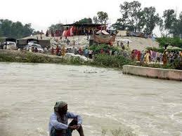
IMPACT OF UTTARKHAND FLASH FLOODS IN MID JUNE 2013 ON LOCAL PEOPLE AT KHARADI VILLAGE (BARKOT BLOCK) IN UTTARKASHI DISTRICT RESULTING FROM A DIVERSION/ REDIRECTION OF THE YAMUNA RIVER TOWARDS POPULATED BANK OF THE RIVER DUE TO THE 8 MW GANGANI HEP. IMPACT IS ALSO THERE ON THE HEP INFRASTRUCTURE ITSELF PUTTING A QUESTION MARK ON ITS QUALITY OF CONSTRUCTION AS ON ITS SUSTAINABILITY.
YAMUNA JIYE ABHIYAAN, JULY 2013 Text by Manoj Mishra
Kharadi is a small road side market place on river Yamuna, some 40 km short of the holy shrine of Yamunotri. It is also a popular night halt site on the Char Dham Yatra route. Resultantly over the period of time a number of hotels and residential properties have come up along the road and the river side.
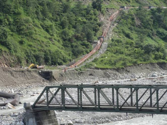
Redirection of the river to the left due to the project head. All Photos taken on 20 July 2013, by Bhim Rawat, Yamuna Jiye Abhiyaan
Some time in 2008-09 works, started by a pvt firm called Regency Gangani Energy Private Limited, immediately upstream of the Kharadi village for the construction of a 8 MW run of the river HEP. The works involved a diversion head, laying of pipes to convey the diverted river water and a power house around 5 km down stream of Kharadi at a place called Gangani. It is notable that the planned HEP is on the proper river Yamuna
By the year 2012, construction works had progressed to a considerable extent, when on the night of 3 August 2012 a cloud burst at Hanuman Chatti area resulted in a flash flood in the river Yamuna. Flow of Yamuna was obstructed by the diversion head of the HEP and was diverted towards its more populated left bank. This diversion swept away of around 9 hotels and residential properties of the local people at Kharadi. It also resulted in damages to the pipes laid in and near the river bed by the HEP.
If the above was not enough then on 17 June 2013, another cloud burst and heavy rains over most of higher reaches of Uttarakhand led to yet another diversion of the river and sweeping away of around 28 properties (see list at the end of this report) in the market village of Kharadi.
Washing away of structures in Kharadi some 500 m downstream from the river diversion head of the Gangani HEP by the flash flood in the river Yamuna on 17 June 2013
The Project also applied for Clean Development Mechanism (CDM) status under United Nations Framework Convention on Climate Change to get Carbon Emission Reduction Credits. Yamuna Jiye Abhiyaan and others have objected to this application at the Validation stage earlier and at registration stage now in August 2013 as the project is not only unsustainable, but its application was full of contradictions and misleading claims. The project is in any case not a sustainable Development Project, is business as usual project and hence non additional as per UNFCCC criteria. The project is also not sustainable development project, but India’s National CDM Authority, namely the Union Ministry of Environment and Forests, has never done credible assessment of this, and never rejected any application of CDM hydro projects!
Road and structures washed away by the flash flood in the Yamuna river downstream from diversion head of the Gangani HEP.Damaged pipes (meant to carry the river water to the Gangani HEP power plant some 3 km d/s from the diversion head) and the damaged approach bridge on the river
List of Hotels and residential properties destroyed in Kharadi village by the flash floods in river Yamuna made worse due to the diversion head of the HEP upstream of the Kharadi village on the night of 16 and morning of 17 June 2013 and on the night of 3 August 2012 around 11 PM made worse (as per local people) due to the Gangnani HEP structure (head) in the river upstream of the village
Property/Hotel Owner Name Father’s Name Village Name No. of Rooms
1 Neel Kanth Hukum Singh Rawat, Sri Lal Singh Khanera Three Storey, 20 rooms
2 Unnamed Jagdish, Chandar Mohan, Ajay Sri Attar Singh Khanera 2 rooms + Provision Shop
3 Yamuna Darshan Jaidev Singh Rana Sri Jandar Singh Khanera 25 rooms
4 Bhupendar Place Rajendar Singh Chouhan, Sri Narendar Singh Syalna 12 Rooms
5 Bhupendar Palace (Joint) Gajendar Singh , Sri Narendar Singh Syalna 04 Rooms
6 Bhupendar Palace (Joint) Arjun Singh, Kesar Singh Syalna 04 Rooms
7 Amit Restaurant Jogindar singh, Sri Chandan Singh Bhansadi 05 Rooms
8 Govind Palace Janak Singh Sri Ranjor Singh Khanera 12 rooms 9 Him Darshan (August 12) Atol Singh, Sri Jai Singh Chouhan Nagon Gaon 22 Rooms
10 Naveen Palace Jag Mohan Chouhan, Sri Jhoon Singh Khanera 06 Rooms
11 Naveen Palace Man Mohan Singh, Sri Jhoon Singh Khanera 04
12 Naveen Palace Dharmendar , Sri Jhoon Singh Khanera 04
13 Vijay Restaurant Vijay Chouhan, Sri Jhoon Singh Khanera 1 Hall, 1 Cottage
14 Naveen Palace Darmyan Singh, Sri Kamal Singh Syalna 07
15 Provision Singh Jagveer Singh chouhan Sri Surveer Chouhan Khanera Provision Shop
16 Ravindar Palace Ravindar Singh Sri Budhi Singh Khanera 04 Rooms 17 Kahniya Palace Shailendar Singh Sri Shiv Singh Khanera 04 Rooms + Restaurant 18 Rana Place Kitab Singh Rana Sri Surb Singh Rana Khanera 04 Rooms
19 Residence Gabar Singh Sri Sultan Singh Khanera 04 Rooms 20 Residence Bijendar Singh Sri Sabal Singh Khanera 07 Rooms
21 Residence Brij Mohan Sri Jogolia Khanera 06 Cottages
23 Residence Chojen Lal Sri Kuta Singh Syalna 04 Rooms 24 Residence Basant Lal Sri Khelan Singh Khanera 03 Rooms 25 Residence Trepan Lal Sri Sadhu Lal Syalna 02 Rooms 26 Residence Jogi Lal Sri Jhapuliyan Khanera 02 Rooms
27 Aneesh Place Aneesh Sri Janbeer Khanera 06 Rooms
28 Residence Jendar Singh Sri Keval Singh Khanera 02 Rooms
29 Residence Praveen Singh Sri Jandar Singh Khanera 02 Rooms
30 Residence Jagendar Singh Sri Keval Singh Khanera 02 Rooms 31 Narayan Place Kendar Singh Payal Sri Ram Singh Syalna 05 Rooms
32 Residence Chain Singh Sri Rompal Singh Syalna 04 Rooms
33 Residence Ispal Singh Sri Khajan Singh Syalna 04 Rooms 34 Narayan Palace (Joint) Ranbeer Singh Sri Ghayan Chand Syalna 04 Cottage
35 Narayan Palace (Joint) Chain Singh Sri Daya Ram Singh Khanera 02 Rooms + Canteen= 02 cottage (About to fall)
36 Giri Ashram Saint Giri Kharadi
37 Trishul Hotel Kandra Singh Payal Sri Ram Singh Syalna Verandah Damaged Bold entry relates to properties washed away in Aug 2012.
NOTE:
About 25 additional Households have now (after June 2013 floods) come with in the slip zone, which can now slip or get washed away any time in the event of high rainfall or another flood.
Entire Kharadi village has now been declared as disaster affected by the District Administration.
YAMUNA JIYE ABHIYAAN, JULY 2013 (Text by Manoj Mishra)
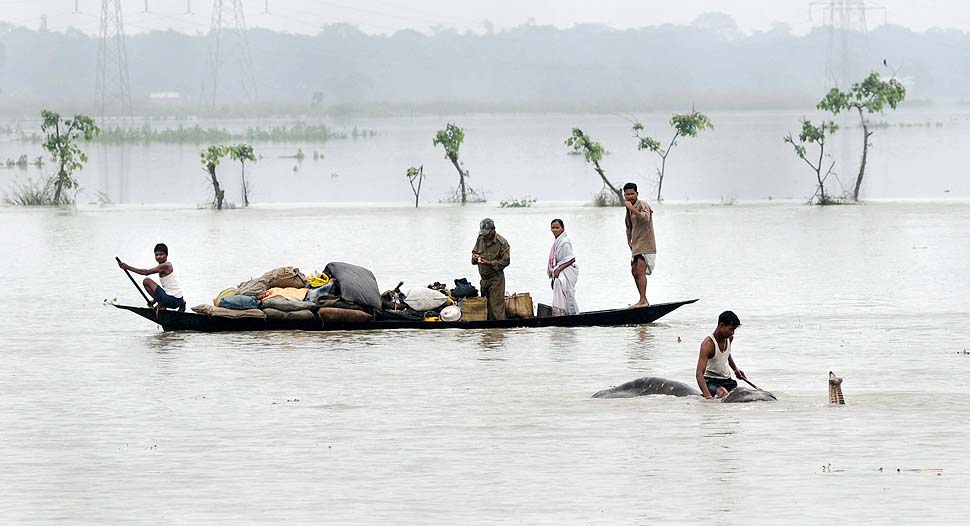
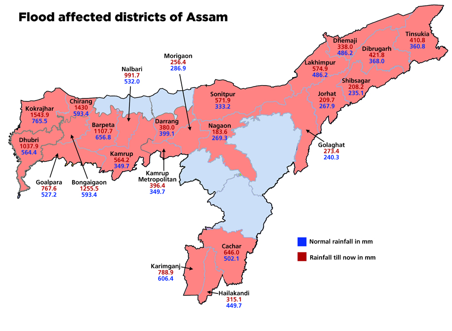
The season of flood havoc has just started in Assam. The Assam State Disaster Management Authority in its daily report published on 28th June 2013, stated that in the last 24 hours 55 villages in Dhemaji, Lakhimpur and Tinsukia district have been affected by flood. All three of these districts are located in upper Assam and three of them shares borders with Arunachal Pradesh. Dhemaji till now is the worst affected among these three. In this district, 13 villages in Dhemaji revenue circle, 28 villages in Sissiborgaon revenue circle and 7 villages in Gogamukh revenue circle has been affected. In Lakhimpur 1 village in Subansiri revenue circle and 6 villages of Doomdooma revenue circle in Tinisukia district has been affected by floods. The report also said that the cumulative number of villages affected till 28th was 70 in four districts which include Golaghat, Kamrup, Jorhat and Karimganj. Continue reading “CWC Flood Forecast 2013 for Assam: Issues Started Arriving before Floods”→
The claim of THDC, CWC and Uttarakhand Chief Minister that in absence of Tehri dam, Rishikesh and Haridwar would have been washed away is completely baseless and unfounded, nothing but a hype. Facts show that if Tehri Dam id not exist, the water level in downstream towns may have risen on June 16-17, before the levels actually rose on June 18 (as per CWC, peak level in Rishikesh was 340.8 m and in Haridwar at 295.1 m, both on June 18), but are likely to be lower than the levels of June 18 since peak flow in Alaknanda (around 11000 cumecs) was lower than that in Bhagirathi (6900 cumecs). THDC and CWC should refrain from making such claims as they are more like adding salt to the wounds that the people of the state are now experiencing and where dams and hydro projects have played a big role.
From all accounts, it is clear that peak flood in Bhagirathi River on which Tehri dam is situated, occurred on June 16 and the peak flood in Alaknanda occurred on June 17 and not at the same time. So it is not rational to add the two peaks happening at different points of time to claim that Tehri saved downstream areas. If Tehri was not there, there could have been floods in downstream a day earlier, but that does not mean peak level would have been much higher than what was the case with Tehri Dam.
From the records available on the websites of Central Water Commission (http://cwc.gov.in/Reservoir_level.htm) and Central Electricity Authority (http://cea.nic.in/daily_hydro.html), it is clear that water level in Tehri reservoir rose from 749 m on June 15 to 776.8 m on June 18 (water levels for June 16 and 17 are not available for some strange reason), this translated to increase in water storage by 652 Million Cubic meters (MCM). THDC claims that they experienced peak inflow of 244 000 cusecs and moderated that to an outflow of 14000 cusecs. To achieve this moderation for a day would take storage capacity of around 563 MCM, so it is plausible that they achieved this moderation on June 16, when Bhagirathi was experiencing peak flow.
However, as we noted earlier, the peak flow in Alaknanda happened on June 17. THDC should make public hourly figures of flow in Bhagirathi and Alaknanda on June 15-19, outflow from Tehri on each of those hours, level of Ganga at Devprayag, Haridwar and Rishikesh, so that everyone can assess the reality of their claim. Such information should in fact be in public domain in routine way.
It cannot be forgotten that:
Areas downstream of Tehri dam faced avoidable and unprecedented flood disaster in September 2010 (for details see page 20 of Aug Sept 2010 issue of Dams, Rivers & People: https://sandrp.in/drp/DRP_Aug_Sept_2010.pdf). If the dam operation is not done properly, we may be in for a repeat later this season.
It should also be recalled that Tehri is a ticking time bomb in the context of large earthquake that is imminent in the state as seismologists are telling us.( including eminent seismologists like Dr. Vinod Gaur. For more details: Earthquakes and Large Dams in Himalayas)
Landslides and debris flowing into Tehri Reservoir. 2012. Matu Jan Sangathan
People affected by the Tehri dam have still not been rehabilitated, the dam has also not been delivering the peaking power it could, as noted by Central Electricity Regulatory Authority. The dam is also silting up much faster than envisaged, reducing its water holding and power generation capacity.
In fact, CWC has failed in its flood forecasting as we made it clear earlier. Both CWC and THDC need to put their house in order rather making unfounded claims.
The current disaster in Uttarakhand has exposed our unpreparedness in many spheres: be it disaster management, weather forecasting, early warning system, tourism management or transparent and participatory environmental governance of a fragile region.
However, we cannot ignore Climate Change and its associated challenges when dealing with these issues.
Himalayas are experiencing Climate Change at an unprecedented rate, this is increasing the incidents of flash floods, GLOFs, landslides and related disasters. India has a huge National Action Plan for Climate Change in place since 2009, under it is a special National Mission for ‘Sustaining Himalayan Ecology’, National Mission on Water, among six others. But what has happened down these years? Are we even considering climate change and its impacts while clearing hundreds of projects on hydel power, river bed mining , urban development, roads and related infrastructure in this region? We are not even assessing the impact of such projects on disaster potential in already vulnerable areas.
Uttarakhand disaster linked to Climate Change However, a number of officials have accepted the climate change link with the current disaster. Secretary of Government of India Ministry of Earth Sciences Shailesh Nayak has now said that the cloudburst that triggered flash floods in Uttarakhand read like a weather phenomenon brought about by warming. He also narrated how the high intensity rainfall is increasing while low and medium intensity events are decreasing. (See: http://timesofindia.indiatimes.com/india/Earth-sciences-secretary-blames-Uttarakhand-rains-on-climate-change/articleshow/20709643.cms)
However, it is an undisputed fact that climate change is impacting the Himalayas at much faster pace than what the global averages tells us. We take a look at our responses to adapt to and mitigate CC Challenges.
1. Unprecedented Climate Change in Himalayas
(This section is largely based on ICIMODs report:The changing Himalayas – Impact ofclimate change on water resources and livelihoods in the Greater Himalayas)
Warming in Himalayas is happening at an unprecedented rate, higher than the global average of 0.74 ˚C over the last 100 years (IPCC, 2007a; Du et al., 2004), at least 2-3 times higher than global averages. Progressively higher warming with higher altitude is a phenomenon prevalent over the whole greater Himalayan region (New et al., 2002).
1.1 Impact on Precipitation: In many areas, a greater proportion of total precipitation appears to be falling as rain than before. As a result, snowmelt begins earlier and winter is shorter; this affects river regimes, natural hazards, water supplies, and people’s livelihoods and infrastructure. The extent and health of high altitude wetlands, green water flows from terrestrial ecosystems, reservoirs, and water flow and sediment transport along rivers and in lakes are also affected.
Throughout the himalayas, there is increasing perception and documentation that precipitation is changing, becoming more erratic and intense. “Flooding may arise as a major development issue. It is projected that more variable, and increasingly direct, rainfall runoff will also lead to more downstream flooding.”(http://lib.icimod.org/record/27016/files/c_attachment_782_6044.pdf, Changing With The Seasons: How Himalayan communities cope with climate change, Chicu Lokgariwar, People’s Science Institute)
1.2 Retreating glaciers:As compared to global averages, Himalyan glaciers are receding at a rapid rate. Retreat in glaciers can destabilize surrounding slopes and may give rise to catastrophic landslides (Ballantyne and Benn, 1994; Dadson and Church, 2005), which can dam streams and sometimes lead to outbreak floods.
Excessive melt waters, often in combination with liquid precipitation, may trigger flash floods or debris flows.Available studies suggest changes in climatic patterns and an increase in extreme events. An increase in the frequency of high intensity rainfall often leading to flash floods and land slides has been reported (Chalise and Khanal, 2001; ICIMOD, 2007a).
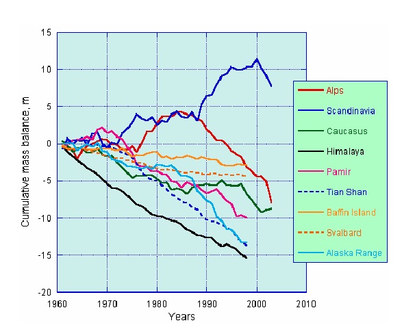
Rapid retreat of Himalayan Glaciers as compared to global averages Courtesy: ICIMOD
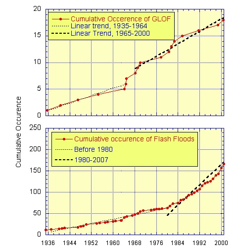
1.3 Higher frequency of flash floods and GLOF events: In the eastern and central Himalayas, glacial melt associated with climate change, has led to the formation of glacial lakes behind terminal moraines. Many of these high-altitude lakes are potentially dangerous. The moraine dams are comparatively weak and can breach suddenly, leading to the discharge of huge volumes of water and debris. The resulting glacial lake outburst floods (GLOFs) can cause catastrophic flooding downstream.
There is an indication that the frequency of GLOF events has increased in recent decades. In the Hindukush Himalayan (HKH) region two hundred and four glacial lakes have been identified as potentially dangerous lakes, which can burst at any time (ICIMOD, 2007b)
Cumulative Frequency of Flash FLoods and GLOFs in Hindukush Himalayan region Courtesy: ICIMOD
2.1 National Mission for Sustaining the Himalayan Ecosystem under the NAPCC:
The ambitious National Action Plan for Climate Change has a separate National Mission for Sustaining the Himalayan Eco System (NMSHE) under the Ministry of Science of Technology, Government of India.
The NMSHE Mission document prepared in 2010 states:
“The mission would attempt to evolve management measures for sustaining and safeguarding the Himalayan glaciers and mountain ecosystem by:
• Enhancing monitoring of Himalayan ecosystem with a focus on recession of Himalayan glaciers and its impact on river system and other downstream socio-ecological processes.
• Establishing observational and monitoring network to assess ecosystem health including freshwater systems.
• Deploying technologies – for hazard mitigation & disaster management, development of ideal human habitats, and agriculture and forest sector innovations
2.1.1 Some Proposed Actions to address Objectives and Goals of the Mission:
Continuous Monitoring of the Eco-system and Data Generation
Enhanced implementation of guidelines for Priority Action in the National Mission on Sustaining the Himalayan Ecosystem
Sustainable Urbanization in Mountain Habitats:This includes:
Town Planning and Adoption and Enforcement of Architectural Norms:
Given the ecological fragility of mountainous areas, it was agreed that rather than permit the unplanned growth of new settlements, there should be consolidation of existing urban settlements, which are governed through land-use planning incorporated in a municipal master plan.
Further action points may include:
(a) Municipal bye-laws will be amended, wherever required, to prohibit construction activity in areas falling in hazard zones or across alignments of natural springs, water sources and watersheds near urban settlements. There will be strict enforcement of these bye-laws, including through imposition of heavy penalties and compulsory demolition of illegal structures.
(e) Construction activity will be prohibited in source-catchment areas of cities, including along mountain lakes and other water bodies. Their feeder channels will also be kept free of building activity.
In order to enable these decisions to be implemented urgently, it is necessary to draw up, as soon as possible, a comprehensive State-wide inventory of such water resources and their channels, which could then be declared fully protected zones.
Promotion of Sustainable Pilgrimage:
Measures for promoting the healthy and sustainable development of religious pilgrimage to the many sacred and holy sites scattered all over the Himalayas, are also necessary. Some of these actions are:
(a) A comprehensive inventory of key pilgrimage sites in each State would be drawn up, which would include analyses of the ecological capacity of each site, based on its location and fragility.
(b) In advance of the results of the above exercise, develop a plan to harmonise the inflow of pilgrims with the capacity of the local environment to cater to the needs of pilgrims. These include the source of several Himalayan rivers, sacred lakes and forest groves.
(c) The construction of roads should be prohibited beyond at least10 kilometres from protected pilgrim sites, thereby creating a much-needed ecological and spiritual buffer zone around these sites. These areas, like national parks and sanctuaries, will be maintained as special areas, where there would be minimal human interference, respecting the pristine nature of thesesites.
(d) Each designated pilgrimage site should have a declared buffer zone where development activity will be carefully regulated.
“Green Road Construction”The construction of roads must fully take into account the environmental fragility of the region. To this end, the concerned State Governments will consider promulgating, as soon as possible, the following guidelines for road construction in hill areas.
(a) Environmental Impact Assessment to be made mandatory for the construction of all state & national roads and expressways of more than 5 km length, including in the extension and widening of existing roads. This will not apply to inter-village roads.
(b) Road construction will provide for the treatment of hill slope instabilities resulting from road-cutting, cross drainage works and culverts, using bio-engineering and other appropriate technologies. Cost estimates for road construction in these areas will henceforth include estimates on this account.
(c) Plans for road construction must provide for disposal of debris from construction sites at suitable and identified locations, so as to avoid ecological damage and scarring of the landscape. Proposals for road construction must henceforth include cost estimates in this regard.
(e) All hill roads must provide adequate roadside drains and, wherever possible, be connected to the natural drainage system of the area.
(f) Alignment of proposed roads should avoid fault zones and historically landslide prone zones.Where this may not be possible, adequate measures will be taken to minimize associated risks, in consultation with experts.
Water security:
The importance of the Himalayas as a natural storehouse and source of water must be acknowledged fully. The region is already under water-stress, with the drying up or blockage of many water sources and natural springs. The following immediate actions, appear to be necessary:
The Himalayan eco system is vulnerable and susceptible to the impacts and consequences of a) changes on account of natural causes, b) climate change resulting from anthropogenic emissions and c) developmental paradigms of the modern society.
Recognizing the importance of scientific and technological inputs required for sustaining the fragile Himalayan Ecosystem, the Ministry of Science and Technology has been charged with the nodal responsibility of coordinating this mission.”
Unfortunately, we saw that NONE of the above is currently happening in the Uttarkhand Himalayas, or for that matter any of the Himalayan States. There are no clear action plans, timelines and budget breakups of this program available and at best, this seems like a vague wish list, rather than an urgent program.
2.2 Uttarakhand State Action Plan for Climate Change:
“Extreme precipitation events have geomorphological significance in the Himalayas where they may cause widespread landslides. Increase in rainfall is likely to causes fresh floods land slides and damages to the landmass. Winter precipitation has become extremely erratic and unpredictable. Increase in the flooding varying between 10 to over 30 percentof the existing magnitudes is expected in all the regions. This has a very severe implication for the existing infrastructure such as dams, bridges, roads, etc., for the areas and shall require appropriate adaptation measures to be taken up.
Strategies:
“The UAPCC recognises that scientific knowledge and evidence base on impacts of climate change to the water sector is limited. As such, a comprehensive water data base in public domain and assessment of the impact of climate change on water resource through the various agencies responsible for different aspects of water resources management in the State will be developed, and updated and analysed on an on-going basis.
Strategies towards this will include:
Review of network of hydrological observation stations
Review of the network of automatic weather stations and automated rain gauge stations
Collection of necessary additional hydro-meteorological and hydrological data for proper assessment of impact of climate change in Himalayan region including other improvements required in hydrometric networks to appropriately address the issues related to the climate change.
Such data will include:
o Hydrological and hydro-meteorological data in low rainfall areas
o Hydrological and hydro-meteorological data above permanent snowline, glaciated areas, seasonal snow areas in Himalayan region
· Improved network for collection of evaporation and rain gauge data using automated sensors
· Establishment/strengthening of ground water monitoring and geohydrologynetworks
· Collection of data about river morphology for monitoring erosion and carrying capacity, and
· Surface and ground water quality data collection, etc.
Other initiatives will include adoption/development of modern technology for measurement of flow in hilly areas, development of water resources information system, and reassessment of basin wise water situation, apart from projection of water resources availability as a result of impact of climate change which would inter-alia include the likely changes in the characteristics of water availability in time and space.
Other necessary studies to improve understanding of climate impacts to the sector will also be carried out from time to time, and robust data mechanisms will be established. Currently, Uttarakhand does not have a State Water Policy. As such, it will be a priority agenda for the State to develop an appropriate policy framework, with explicit cognisance of climate concerns.”
Unfortunately, here too we did not find evidence that ANY of the strategies were put in practice. As we have said earlier, we still do not have a picture of how much rainfall occurred where and when. Rudraprayag district seems to have a single raingauge station, and high density tourist spots like Kedarnath, which are already vulnerable do not even have a raingauge. There exists no early warning system and as clarified by CAG report on Disaster Management, 2013, the State Disaster Management Authority has not met even once since its constituion in 2007.
3. Hydropower and Climate Change: Time to bust the myths
Hydropower projects are being aggressively pushed for their supposedly benign role in global warming and climate change. However, world over, there is increasing consensus that Hydropower dams are not only extremely vulnerable to climate change but (http://ieeexplore.ieee.org/xpl/login.jsp?tp=&arnumber=1007423&url=http%3A%2F%2Fieeexplore.ieee.org%2Fiel5%2F2195%2F21734%2F01007423), but actually contribute to global warming and climate change, depending on their size and nature. They are being increasingly recognized as being ‘False Solutions to Climate change.’
Many hydropower projects being planned, under construction or commissioned in Uttarakhand ( and across Indian Himalayas) are storage dams with reservoirs. Even the so called ‘run of the river’ projects involve reservoirs and big dams. These reservoirs emit methane (21 times more potent than carbon dioxide) and carbon dioxide. It is now proved that methane is not only emitted from reservoirs, but that it is boosted at each dam turbines and draw-down (Ref: http://news.wsu.edu/pages/publications.asp?Action=Detail&PublicationID=32301)
4. Environmental Clearances to Hydropower Dams do not consider Climate Change impacts or mitigation methods:
Despite the burgeoning literature, debates around the world, several submissions from civil society including SANDRP, there is not even as assessment of the impacts of hydel projects on climate change, leave alone mitigation measures. The Expert Appraisal Committee on River valley and Hydropower Projects constituted by the MoEF which recommends Terms and Reference and further Environmental Clearances to these projects has not included the impacts of climate change or the mitigation measures against impacts while recommending TORs or granting Environmental Clearances. It also does not include assessment of impact of the projects on disaster potential of the region or adaptation capacity of the people. The EAC in fact has zero rejection rate even when we know we do not have credible EIA, SIA or CIA for any projects or basins.
Many of the Hydropower projects in the Himalayas, including Uttarakhand have applied for carbon credits under the UNFCCC’s Clean Development Mechanism. Under this, clean energy projects in developing countries get millions of rupees as incentives from developed world, which in turn get carbon offset credits, which are a license to pollute further. The entire system, put in place after the Kyoto Protocol is inherently flawed due to absence of due attention impact of projects on adaptation of local people, to local voices and due to market based approach. Many destructive hydropower projects in Uttarakhand are being certified as clean projects, making a mockery of climate change adaptation and sustainable development. Notable among-st these include the 99 MW Singoli Bhatwari HEP , 76 MW Phata Byung HEP, both on Mandakini river (epicenter of current disaster), 300 MW Alaknanda (GMR) hydropower project, 330 MW Alaknanda Srinagar Hydropower project, 414 MW Rampur project in Himachal Pradesh, where the World Bank played an active role in getting it registered for Carbon credits.
Carbon credits to large hydropower projects in fact accelerate climate change and its impact on ecosystems and communities and is unacceptable.
6. Dubious role of World Bank and Asian Development Bank
World Bank is being reported to have come up with a report which says that “An extremely wet monsoon that at present has a chance of occurring only once in 100 years is projected to occur every 10 years by the end of this century,” It also projected a rise in severe floods within the next 25 years.
The same organisation is pushing some of the biggest and most destructive hydropower projects in the Himalayan region like the 775 MW Luhri HEP, in addition to 2 large Hydel projects upstream on Luhri in the Sutlej Basin in Himachal Pradesh. Luhri HEP will have one of the longest tunnels in Asia and there is no impacts assessment of the impact of this blasting and tunnelling on the villages above, or geological stability.
World Bank is also pushing and financing the 440 MW Vishnugad Pipalkoti Hydropower in Uttarakhand. Incidentally, Pipalkoti region experienced some severe impacts of the current deluge and also suffered damages as per MATU report. The World Bank is supporting these projects even when there are no credible project specific ESIA or cumulative impact assessment studies or carrying capacity studies or studies on the impacts of these cascade projects on disaster risks or climate change.
Asian Development Bank is also supporting a number of hydropower projects n Uttarakhand (they are reported to have suffered damages) and in Himachal Pradesh on similar lines.
Cascade projects along the rivers, with no distance between two projects effectively means that the entire landscape surrounding the rivers is blasted, submerged and tunneled.
There is a huge gap between what World Bank’s says and what it does as far as hydropower and climate change is concerned.
In Conclusion:
Current Uttarakhand disaster has seen government officials to the World Bank suggesting that impacts of climate change are severe, but ironically, when asked specifically if they would link current disaster with climate change, they say that cannot be established and hide behind ‘scientific uncertainity’.
As has been seen world over, the poor and most vulnerable sections of the society and the ecology are worst impacted by climate change. It is high time that we adopt no regret strategies to cope with impacts of climate change, through mitigation and adaptation.
National Action Plan of Climate Change needs to be audited for its efficacy and work from organisations like CAG. MoEF urgently needs to include impacts of climate change while it is busy sanctioning all the projects that come to it. Organizations like World Bank need to walk their talk on climate change and stop financing destructive hydro projects in this fragile region, in absence of any studies on their impact on Climate Change and lives and livelihoods of millions dependent on natural systems.
Climate change is knocking at some of our doors, while it has already arrived through other doors. We can choose to close our eyes and ears and say “this is normal and expected in this region”. But if we do not respond to challenges posed by Climate Change urgently, it wont be just politely knocking, but causing extreme damage, as it is being witnessed.
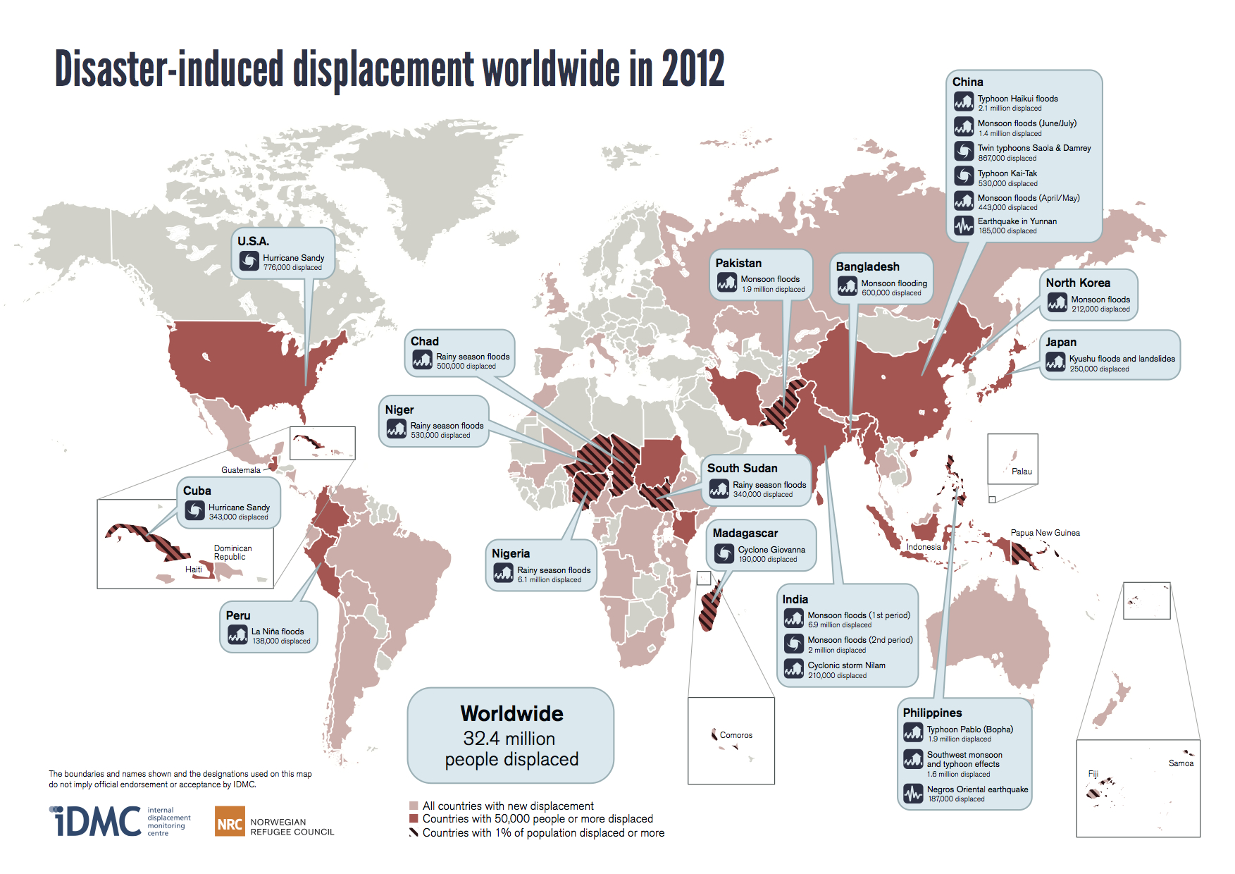
According to a new report, the largest climate induced displacement in the world for the year 2012 happened
Cover of the IDMC Report on Disaster Induced Displacement
in two states of Northeast India, Assam and Arunachal Pradesh in June 2012 due to the monsoon floods which displaced 6.9 million people, constituting about 21.2% of the population of the two states[1]. This staggering fact was revealed in the report named “Global Estimates 2012 – People Displaced by Disasters” published by The Internal Displacement Monitoring Centre (IDMC) based in Geneva, Switzerland in May 2013. More people were displaced in India by natural disasters last year than in any other country, says the report. A closer scrutiny shows that the figure seems highly exaggerated, raising question mark over the accuracy of the work of IDMC and Norwegian Refugee Council (NRC), who jointly published the report.
IDMC is an international body monitoring internal displacement worldwide. This was established in 1998 by the NRC. IDMC defines displacement as a non volunteer nature of movement. People who are compelled to evacuate their homes in order to avoid the impacts or the threat of a disaster will come under this definition. But from this definition it is also clear that those people who are affected by any disaster but have not evacuated their place living will not be defined as displaced. IDMC states that majority of people who face displacement are internally displaced people (IDPs).[2]
Displacement by type of related hazard, 2012 and 2008-2012
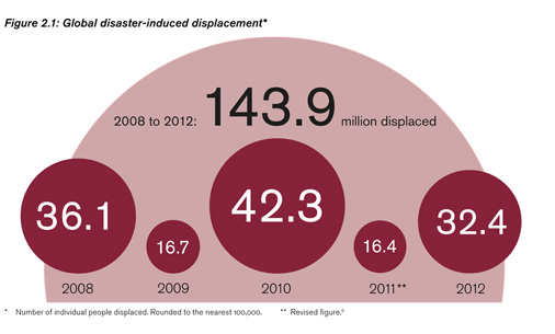
This report states that in 2012, an estimated 32.4 million people in 82 countries were newly displaced by disasters associated with natural hazard events. Over five years from 2008 to 2012, around 144 million people were forced from their homes in 125 countries. The majority of this displacement (98% in 2012 and 83% over five years) occurred due to climate and weather related hazards which include floods, storm, etc.
In the year 2012, twenty disaster-induced displacement events were recorded, which were induced by flood and storm related disasters. Out of these, fourteen happened in Asia which includes the mass displacement in India, China and Philippines. Large scale flood displacements also happened in African countries of Nigeria, Chad, Niger and South Sudan. In fact the Nigerian floods also displaced over six million people. Hurricane Sandy brought the disaster for the west which rendered 775,000 people homeless in America and 343,000 people in Cuba.
Why Disaster Induced Displacements are Increasing The report says that related and interconnected global changes like population growth, rapid urbanisation and the exposure of vulnerable communities, homes and livelihoods to hazards will increase the risk of global disasters. Even though increasing use of life saving drugs have brought down mortality rate related with weather related hazards, number of disaster survivors getting displaced will not decrease.
The analysis done in the report shows that disaster induced displacement takes a toll on both high income and low income countries. However, it is the middle and low income countries where majority of the people were displaced. The report states that for the year 2012, 96.09% of disaster induced displacement happened in the middle and low income countries, whereas for the period of 2008-2012 it was 98.27%. The report also identifies that the South Asia region had the highest disaster related displacement (36.4%) for the year 2012. From 2008 to 2012, the highest disaster induced displacements have happened in China (49,782,000) which is followed by India (23,775,000) and Pakistan (14,991,000).
Risk of the Unseen – Climate Change The impact of climate change on disaster induced displacement has been emphasized in the report. The report states that climate change is an important concern which will impact extreme weather events which could lead to more displacement. Intergovernmental Panel on Climate Change (IPCC) published a report in March 2012, Managing the Risks of Extreme Events and Disasters to Advance Climate Change Adaptation (SREX) in which relationship between extreme weather or climate events (“climate extremes”) and displacement has been acknowledged, “Although data on climate change-forced displacement is incomplete, it is clear that the many outcomes of climate change processes will be seen and felt as disasters by the affected populations. For people affected by disasters, subsequent displacement and resettlement often constitute a second disaster in their lives.”[4] Evidence suggests that climate extremes are becoming more and more unpredictable due to the impact of climate change which has changed the frequency and magnitude of these climate extremes. This could be very serious issue considering the impact climate extremes can have on displacement. The report however fails to point out that while high income countries have been responsible for the climate change to the greatest extent, the impacts of their emissions are being felt by the poorest people in the low income countries and middle income countries.
Displacement in Northeast The report says that that around 900,000 people were evacuated in Arunachal Pradesh in June-July 2012; two thirds of the state’s population. In Assam, the report says, quoting Central Water Commission that as many as six million, 20 per cent of the state’s population, were forced to flee by rising waters. It says, officials claimed the 2012 floods were the worst since 2004 when eight times more houses were recorded as damaged than in an average year.
Rainfall in June 2012 does not corroborate IDMC claims – Monsoon rain is the reason for the floods in June 2012. The table below presents the rainfall figures of Assam and Arunachal Pradesh during June 2012.
1-13 June
14-20 June
21-27 June
28 June – 4 July
Arunachal Pradesh
191.6 (+1%)
64.1 (-47.1%)
249 (+78%)
66.2 (-51%)
Assam & Meghalaya
189.4 (-3.5%)
123.7 (-9%)
251.8 (+105%)
65.2 (-51%)
Note: Rainfall in mm, figures in bracket indicate the % departure from Normal, all figures from weekly and seasonal rainfall maps of India Meteorological department.
It is clear from the above table that rainfall in June 2012 in Assam and Arunachal Pradesh was normal or below normal in all weeks except during June 21-27, 2012. Even the excess rain in this period is not too high to cause unprecedented flood displacement. This raises some doubt about the figures in the IDMC report.
Assam suffers annually from flood disasters. The havoc of floods paralyses the state for several months every year. International recognition of this problem is very important for the state. However, that seems to be some significant exaggeration in the figure of displacement in NE India due to floods in June 2012.
The total population Arunachal Pradesh is 1,382,611 according to 2011 census[5] and displacement of 900,000 people would mean displacement of massive 65% population of the state. But we could not find any report or news confirming displacement of this huge extent. There was news about floods in several districts in Arunachal Pradesh in June and July 2012, but none corroborated the displacement figure of 900,000. In fact displacement of 65% population of Arunachal Pradesh due to floods have never been heard of for even the worst ever floods in the state.
For Assam, the flood in June 2012 was recorded as the worst floods in last ten years. The flood in June 2012 was termed as unprecedented by Dr. Partha Jyoti Das, a senior researcher working on flood and environment related issues in Assam. He said that the flood occurred quite earlier than the previous years, i.e. in the first few weeks of June.[6] However we found it difficult to find any document corroborating the displacement figure of six million in Assam due to floods in June 2012.
On the National Disaster Management website of Government of India (http://ndmindia.nic.in/flood-2012/floods2012.htm) the highest number of people affected during the month of June and July was 1,992,727 (reported on 2nd July 2012). The highest number of people evacuated during this time was 383,421 (reported on 4th July 2012). The highest number of people found in the relief camps was 484,555 (reported on 15th July 2012). The Assam State Disaster Management Authority also corroborated this figure as the highest number of people reported in the relief camps during that period. Two tables providing extent of damage (cumulative figures) and rescue and relief (provisional) are given in Annexure1 and Annexure 2.
Figures from Oxfam India, one of the leading organizations providing flood relief in the state also validated the fact that the flood in June 2012 was unprecedented early flood and worst in last ten years. They maintained that due to this flood nearly 2.4 million people have been affected and half a million people have been displaced.[7] The IDMC report also refers to the information gathered from Sphere India and Inter Agency Group (IAG). We found that in a Joint Assessment Report of IAG Assam on Assam Flood 2012 (published on 6th July, 2012) the number of affected people was stated as 2,391,369 in 4,540 villages. In the same report 383,421 inmates were reported to be staying in 650 relief camps in 15 districts of the state.
We had written to IDMC (at the email address idmc@nrc.ch as provided in the document for any further information and referred documents) on June 13, 2013, for copies of the documents referred in end note 11 and in table A2.1, and also request to “provide any other report that provides details and support for the figure of 6.9 million people displaced by flood disaster in North East India in June July 2012”. Our email remains unanswered as we write this.
Dr. Arupjyoti Saikia, an environment historian working on northeast after seeing the report said that “I have no accurate estimate of the people being displaced. But equally the estimate provided by the IDMC seems little awkward. The numbers of people affected in AP is surely less for very natural reasons. Often IDMC reports are criticized for their over-reaction. Official figures matter a lot as this numbers help in procuring relief from the GOI as well as other agencies. I presume GOA reports will come closer to the truth.” Dr. Dulal Chandra Goswami, another senior scholar from northeast, said that the displacement figures for northeast, quoted in the report appear to be highly exaggerated. Dr. Partha Jyoti Das also expressed similar opinions saying that the figures mentioned in the IDMC report for northeast are overestimated. Many reporters may accept the figures in such reports uncritically and report them, which lead to spreading of wrong information. This was evident from the reports published in Down to Earth[8] and Thomson Reuters Foundation[9].
Moreover, displacement in Assam is not only induced by floods but also by erosion. The report does mention “Shelter needs were a primary humanitarian concern as the authorities encouraged IDPs to leave relief camps and return to water-logged villages, destroyed houses and eroded land”. But this is not completely correct as erosion leads to permanent displacement of people from their original land. Floods lead to inundation of a certain area for a period of time displacing people temporarily from their homes. But erosion displaces people permanently from their land. In displacements induced by floods the displaced people have the option of going back to their houses. Erosion leaves no option for that. People who get affected by erosion have to shift their homes before the actual erosion happens. In 2007 it was stated in the State Assembly that in 15 out of 23 districts in the state 40,414.98 bighas of land was lost due to erosion. 10,075 families have lost their houses due to erosion in that year. Many people who get displaced due to erosion opt to live on the side of the embankments in poor living conditions for years due to their inability to buy new land. They might not come to relief camp during floods which may result in their non-recognition in official displacement figures.
Such kind of reports also need to recognise clearly that among the disaster induced displacement, it is the poor people who are most at risk even in a fast growing country like India and climate change is making them even more vulnerable. Hence there is an urgent need to ensure that the climate action plans address the vulnerabilities of the poor. Unfortunately, Indian government’s National Action Plan on Climate Change (NAPCC) does not even recognise the vulnerable classes of people. In fact NAPCC increases the vulnerability of the poor, since it basically follows the business as usual development path.
This report by IDMC is an important initiative to document the plight of the people who face displacement due to the disasters. Recording and documentation of displacement is very important for policy formulation as well as for all related discussions and debates. The numbers presented are shocking but are clearly unsubstantiated and exaggerated. However exaggerated facts will also not lead to healthy policy formulation. Besides, factual inaccuracies may lead to questioning the credibility of such reports. We hope that IDMC will acknowledge these errors and bring more factual accuracy in their future reports. Such reports also need to highlight the issue of climate justice.
Parag Jyoti Saikia and Himanshu Thakkar
South Asia Network on Dams, Rivers & People (www.sandrp.in)
[2] As defined by the 1998 Guiding Principles on Internal Displacement, internally displaced people (IDPs) are individuals or groups of people “who have been forced or obliged to flee or to leave their homes or places of
habitual residence […] and who have not crossed an internationally recognised state border.”
[3] This figure is clearly gross error. The total Disaster induced displacement in 2012 by all types of hazards is 32.4 million, so storm related disaster cannot displace 95.7 million people. We have used a corrected figure in the table here, based on total displacement subtracted by displacement by other (than storm) factors.
Pic: 1Erosion in Rohmoria in the Upstream of Dibrugarh. Source: The Assam Tribune
The National Disaster Management Authority (NDMA) has recently published a report named “Study of Brahmaputra River Erosion and Its Control”. NDMA had commissioned this study to the Department of Water Resources Development and Management of IIT Roorkee. NDMA is an apex body constituted under the Disaster Management Act, 2005 to prepare the country to face natural and human-made disasters. NDMA is headed by the Prime Minster of India. Under the natural disasters category it includes earthquake, flood, tsunami, land slide and avalanches while nuclear, chemical or biological disasters have been categorized as human-made disasters. This report provides a lot of information and data on the Brahmaputra and its tributaries. The information about erosion is also very much detailed and descriptive. The report can be found at http://ndma.gov.in/ndma/latestdisasterupdates/NDMA%20Final%20Report%20Brahmaputra%20River.pdf
Pic: 2 Recent News Reports of Erosion in Subansiri River, One of the Largest Tributaries of Brahmaputra on the North Bank. Source: Dainik Janambhumi
Pic: 3 Houses on the side of the Old Embankment in Matmora. Source: Parag Jyoti Saikia
This reports deals with a very serious issue of erosion in the Brahmaputra river basin in Assam. Erosion should not be confused with floods even though both are annual phenomena in the Brahmaputra river basin. Erosion can be seen to have a more severe impact than floods because erosion leads to permanent loss of land and property. During floods land and houses are submerged for a period of time. But erosion displaces people from their land and property for good. Erosion inflicts severe damage to agriculture, economy and cultural relations of people. Erosion compels people to migrate to different places. Villages get eroded one after another and people living in those villages have to move to another location with their belongings. But this may not be possible and affordable for all those who lost their land in erosion. So for many of them, living on the side of embankments in very poor living conditions remains as the only option. Erosion also leads to migration of rural youths to urban areas in search of jobs. In the last few decades erosion has posed as a greater threat to the people of Assam than floods. The severity of erosion can be seen from the Table 7 of the report in which Satellite Based Estimation and Comparison of Area Eroded In Brahmaputra during the Period 1990 to 2007-08 and 1997 to 2007-08 have been presented.
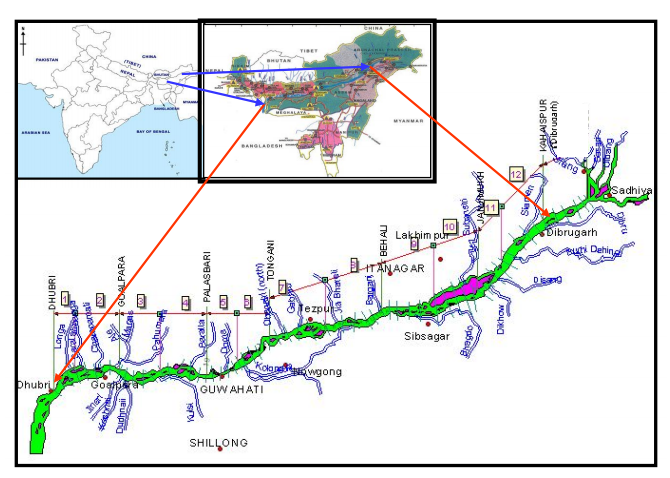
Map of the Study Area from the Report
The study divides the river length into twelve segments from Dhubri to Dibrugarh and that is why there are 12 reaches mentioned in the table. It is clear from this table that the while the erosion prone length of the river is 10% higher along the South Bank of Brahmaputra compared to the same along North Bank. Areas facing erosion is 123% higher in South bank during the last decade (1998-2008) of the study period. The highest erosion area/per km of erosion prone bank is upstream of Dibrugarh, where the river enters the plains from the hills.
Areawise division into 12 reaches in the river
North Bank
South Bank
Total Erosion Length
(in km)
1990 to 2007 – 08 (in sq. km)
1997 to 2007-08 (in sq. km)
Total Erosion Length
(in km)
1990 to 2007 – 08 (in sq. km)
1997 to 2007-08 (in sq. km)
1. Dhubri
40.19
124.461
94.129
7.05
194.983
10.791
2. Goalpara
39.5
79.046
40.902
4.85
17.816
5.052
3. Palasbari
54.87
48.668
42.914
14.02
23.006
15.859
4. Guwahati
21.02
7.92
1.654
24.38
5.385
12.079
5. Morigaon – Mangaldai
6
35.606
2.138
47.91
96.979
103.7
6. Morigaon – Dihing
24.86
29.057
7.275
47.8
10.795
56.72
7. Tezpur
8.58
38.758
4.733
52.95
16.628
44.774
8. Tezpur-Gohpur
8.85
31.187
5.794
44.16
26.098
71.227
9. Majuli-Bessamora
24.69
25.562
12.327
47.17
32.788
28.998
10. Majuli Sibsagar
16.93
60.657
16.878
54.95
44.018
42.118
11. Dibrugarh
37.86
37.506
43.529
43.89
46.595
6.066
12. U/s Dibrugarh
70.5
20.376
55.454
57.54
399.529
333.416
Total
353.85
538.805
327.726
389.13
914.62
730.8
The Study Report:There have been a lot of studies done on the river, to find a solution to the issue. But what comes as a surprise is the attempt to shy away with some of the crucial issues of the riverine eco-system in the northeast. But before going into crucial issues, a brief note about the report is provided.
The March 2012 study is divided into two phases. The first phase is named as ‘Sattelite Data Based Assessment of Stream Bank Erosion of Main Stem Brahmaputra and Its Major Tributaries’. In the second phase processing and analysis of the hydrological data of the Brahmaputra and its tributaries has been done.
In the first phase of the study information and data of 18 years (1990 to 2008) has been put together. The study pertains to a reach of 620 km on the main stem of Brahmaputra River, i.e., its entire course in Assam from upstream of Dibrugarh up to the town Dhubri near Bangladesh border. 23 major tributaries (13 northern and 10 southern) within India have also been considered. The data for this whole area was collected using an integrated mechanism of Remote Sensing and Geographical Information System.
In the second phase of the study a new method of analysis called Artificial Neural Networks (ANNs) has been used. The data processed through this analysis has been used for modeling the rainfall-runoff process and runoff-sediment process for the study area.
The report identifies inherent ‘sediment overloading’ of the river fluvial system as the main cause for river bank erosion vis-à-vis channel instability in Brahmaputra. The report recommends by proposing river training works for two pilot areas on Brahmaputra River. The first site is in Bhuragaon of Morigaon district and second one is near the Guwahati airport.
Critical issues:
The team of investigators for this study was led by Prof Nayan Sharma of the Department of Water Resources Development and Management at IIT Roorkee. This is a very descriptive report from the point of information and data about the river Brahmaputra and its tributaries. But even then there are several things that the report does not mention at all.
The report mentioned that inherent ‘sediment overloading’ as the prime cause for erosion in the river Brahmaputra. But another study named “River Bank Erosion and Restoration in the Brahmaputra River in India” has identified several other factors responsible for bank erosion.[1] That study states “The salient hydraulic and bank material factors responsible for bank erosion of the Brahmaputra system are i) rate of rise and fall of river water level, ii) number and position of major channel active during flood stage, iii) angle at which the thalweg approaches the bank line, iv) amount of scour and deposition that occurs during flood, v) variability of cohesive soil in bank material composition, vi) formation and movement of large bed forms, vii) intensity of bank slumping, and viii) progression of abandoned river courses to present-day channel.”
Identifying only ‘sediment overloading’ as the main reason for a dynamic river system like Brahmaputra seems an over simplification that overlooks the critical issues.
Pic: 4 A view of the Balijan Tea Estate Eroded by the Brahmaputra in Rohmoria in Dibrugarh district of Assam. Source: The Hindu
Even though the report identifies sediment overload as the prime cause of erosion, it has provided insufficient analysis as to why the sediment load is actually increasing in Brahmaputra. The report rightly states “Accelerated erosion has occurred in this region due to intensive deforestation, large – scale road construction, mining and cultivation on steep slopes.”
Pro Hydro Bias:Here the report completely ignores case of hydropower development in Arunachal Pradesh and its impact on Brahmaputra and its tributaries. The report nowhere mentions about the proposals for 168 hydroelectric dams in Arunachal Pradesh and its impact in the rivers in Assam. In the recent times, the state has witnessed mass protest against hydropower development in Arunachal Pradesh. In fact the report shows a pro-hydro bias when it laments that “less than 5% of the existing hydropower potential” have been put to use so far. At a time when people are demanding for cumulative impact assessment of dams on the rivers of Assam, reports like this attempt to create confusion among people. It is to be noted that when Assam was witnessing the mass protest against big dams, it was Dr. Nayan Sharma who appeared in the electronic media advocating for big dams.
Pic: 5 Erosion protection work at Nimatighat on the Brahmaputra in Jorhat District on May 5th 2013. Source: http://www.prokerala.com[2]
Bias for Structural Intervention: This report advocates for structural intervention for flood protection and reiterates the need for more embankments. Lots of analysis has been done on the ill effects and poor performance of embankments. Embankments essentially transfer the problems to the downstream. There are ample examples of how structural interventions made for erosion protection have failed. We can take the example of Rohmoria, located in the upstream of Dibrugarh town in this regard. There were a series of structural interventions made to control erosion but it failed.[3]
The embankments proposed in this report for the two pilot-study areas are proposed to be constructed using geo synthetic bags. The geo-synthetic bags will be put inside polymer rope gabions[4] and installed in the critical toe of the bank line. The efficacy of controlling erosion through geo-tube embankments still not established, but even then geo-tubes have become the buzz-word for flood protection in Assam. The Asian Development Bank has offered a loan of $12 million for erosion protection through construction of geo-tube embankments. But Assam government engineers working on Brahmaputra and its tributaries are critical of ADB’s programme of erosion control through geo-tube. In a report published in regional news paper on March 2010, it was stated that revetments like geo-bags cannot be successful in Brahmaputra because it creates a permanent deep channel along the existing river bank.[5] The report also stated that geo-synthetic bags which were installed for bank protection in Palashbari-Gumi area were washed away by Brahmaputra. This area is in the downstream of Saraighat Bridge and close to Guwahati airport area where one of the pilot projects has been proposed.
Impact of Structural Interventions Ignored:The report provides structural solution for erosion control but ignores erosions which were a result of structural interventions in the river. Studies on Brahmaputra basin have shown that during and after the construction of bridges in the river Brahmputra erosion and floods have increased in the downstream areas.[6] In the case of Saraighat Bridge, unprecedented flood and erosion was witnessed in Palasbari and Gumi area. Morigaona and Nagaon districts suffered the same after the construction of Koliabhomora Bridge. Construction of Naranarayan Setu, led to flood and erosion in Dakshin Salmara, Pancharatna and Mancachar.
Similar fears have been expressed for the fourth bridge on Brahmaputra which is under construction between Bogibeel of Dibrugarh district and Kareng Chapori of Dhemaji district. The river is nearly 9 km wide at this point. But for the construction of this bridge, the river had been shrunk to almost 5 km through the boulder spurs. This is posing a great threat of flood and erosion for the downstream areas which include famous river island Majuli and Matmora, where India’s first geo-tube embankment was constructed. Engineers who are involved in the construction of the dykes of the fourth bridge had been reported saying that Matmora area would come under severe threat due to the increased river pressure in the area. The report completely ignores all these facts and shows ‘sediment overloading’ as the cause of erosion.
Besides, the study gives a feeling that erosion in the river Brahmaputra operates in ceteris paribus[7]. The report made no mention about climate change and how it is going to impact a river like Brahmaputra which is flowing right from the Himalayan mountain range. At a time when impacts of climate change are taken into account for every possible environment related matters, ignoring this is another major lacuna of this report.
These critical lacunas put a question mark over the usefulness of the otherwise informative study. Credibility of IIT Roorkee reports have been questioned in the past too.[8] NDMA may keep this in mind and focus on more basic issues. For starters as monsoon sets in and rounds of floods start along Brahmaputra, NDMA’s flood forecasting links have stopped functioning for five days as we publish this in the 1st week of June 2013.
Parag Jyoti Saikia
South Asia Network on Dams, Rivers & People (www.sandrp.in)
[4] Gabions are sausages made of Polymer ropes that are appropriately woven by a special process to fabricate the Gabions in various sizes. Gabions are generally available in a prefabricated collapsible form. Images of polymer rope gabions can be found here – http://www.garwareropes.com/polymer_rope_pro_g.htm
[6] Mahanta, C; Mahanta, A., ‘Bridge over The Brahmaputra’ Economic and Political Weekly, pp 579-581, 2006
[7] Ceteris paribus is a Latin phrase which can be literally translated as “holding other things constant” and usually rendered in English as “all other things being equal”
This week, there was news that Nepal and India have agreed to ‘strengthen’ the embankments on shared rivers like Bagmati, Kamla and Khando in a bid to control floods. “Both the countries have already agreed to strengthen embankments of Bagmati, Kamla, Lalbakeya and Khando rivers and extend the embankments along these rivers to higher ground in Nepal to control spilling of flood water,” Water Resources Minister Harish Rawat said” (http://economictimes.indiatimes.com/news/politics-and-nation/india-nepal-agree-to-strengthen-river-banks-to-avoid-floods/articleshow/19035269.cms)
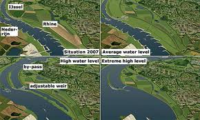
Now while we are busy building our embankments higher and higher, one of the most flood prone country in the world: The Netherlands is doing something drastically different. Through its ‘Room for the River’ Program, Netherlands is actually leaving spaces for floods to spill, and minimise the damage, rather than building higher and higher embankments.
“After 800 years of building dikes, we’ve been making them higher and higher,” said Gert-Jan Meulepas, project manager at Royal Haskoning, an engineering and environmental consultancy that developed the project. “But if something goes wrong, the damage will be greater.” (http://www.scientificamerican.com/article.cfm?id=how-the-dutch-make-room-for-the-river)
With Climate Change and extreme weather events a reality, the focus in Europe and America has shifted from making ‘Zero Failure’ infrastructure to infrastructure that is ‘allowed to fail’ with other protective measures in place like flood dissipation, protected floodplains, alert disaster management, etc. “Designing projects so they are safe to fail, is often cheaper and more efficient, Kirshen believes. A community might opt to build a dam designed to contain up to a 100-year flood, then develop a comprehensive evacuation plan for the surrounding area in the event of a more severe flood. This strategy anticipates that the dam may not control extreme flooding, but adds other protective measures for higher levels of safety.”http://www.climatecentral.org/news/for-engineers-climate-failure-becomes-an-option-15769
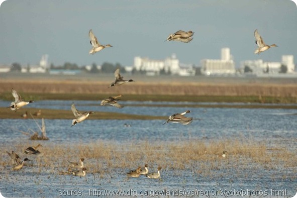
One of the best examples of this flexible management is the Yolo Bypass in the Sacramento Basin in California. Yolo Bypass actually accumulates floodwaters in case of extreme floods and is used by water fowl and wildlife. It is the largest public/private restoration project west of the Florida Everglades. The entire bypass forms a valuable wetland habitat when flooded during the winter and spring rainy season. In the summer, areas of the bypass outside the wildlife areas are used for agriculture.(http://www.yolobasin.org/wildlife.cfm)
India and South Asia on the other hand, though facing severe threats from climate change and floods and with a history of embankment breaches are refusing to learn lessons. The recent discussion about strengthening embankments between India and Nepal seems to be a result of this mindset which is not flexible to include ecosystems, goods and services of floodplains and climate change challenges.
Shri. D. K. Mishra jee has written extensively about embankments and floods in Bihar. His latest book on Bagamati: https://sandrp.in/pub/River_Bagmati_Bounties_Become_A_Curse.pdf