Dams · Hydropower · Uttarakhand

Uttarakhand Floods of June 2013: Curtain Raiser on the Events at NHPC’s 280 MW Dhauliganga HEP

box 2
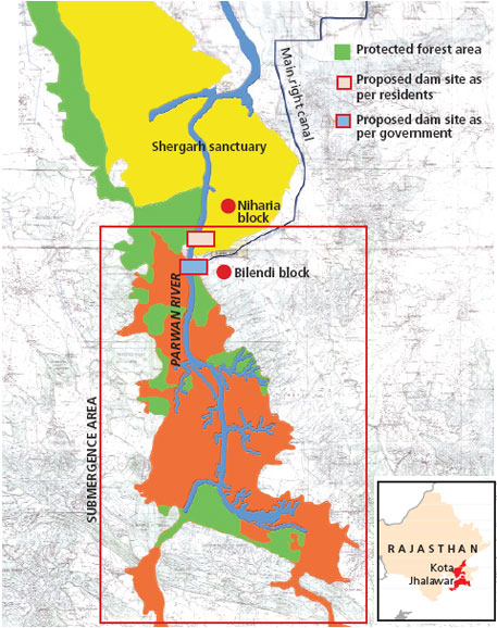
Days after walking down the Gori, we go to the Sub-Divisional Magistrate of Dharchula sub-division, Pramod Kumar, who is busy coordinating rescue and relief on a war-footing, but still has the courtesy to meet. On being asked by me regarding the sudden release of water by the 280 MW National Hydro-Power Corporation (NHPC) Dhauliganga Hydro-Electric Project (HEP, see below the layout of the project given on NHPC website) at Chirkila and the ensuing damage downstream, he confirms that he received an emergency call on the night of 16th June, 2013 from the NHPC, asking that they be permitted to release the impounded water in their reservoir, because it was in danger of breaching. Under normal circumstances they do not need his permission. He also confirms that he had refused, because the water level in the Mahakali main-stem was already flowing at danger-mark. NHPC went right ahead and opened their gates at full on the night of 16th June, without authorization or any prior warning to anybody[1] but their own office-residence complex 20 km downstream, at Dobat.

Map of Dhauliganga Dam Source: NHPC
Map of Dhauliganga Dam
Source: NHPC

Was this really an emergency, or was this purely opportunistic on the part of NHPC to take this opportunity early in the season to flush their reservoir that had been filled almost to half with bed-load and silt? We went looking for clues and information. I went to the NHPC office complex at Dobat, and met Bhuvan Chand Joshi, their Public Relations Officer. After giving me the spiel on how safe, and how green this so called run-of-the-river (ROR) project was, constructed by no less than the Japanese, the Germans and the Koreans put together[2], he admitted that their underground power-station was entirely flooded. Housed in a gigantic underground cavern about 100 meters long, four-storeys high at 40 meters and about 16 meters wide, river water had filled it right upto the control-room on the fourth floor. I had already been told by Kesar Singh Dhami, taxi owner of Dharchula, that on the 16th June itself, when he was ferrying the first batch of Kailash yatris to the road-head on their way up to Tibet, he had noticed the reservoir was filled high already with flood-waters, with large uprooted trees and other woody debris floating at the damsite. He confirms that water was being released, but only a small release, despite the dam being fuller than he had ever seen it.

I was also told by another employee of NHPC (who did not wish to be named) that what had gone wrong was that despite the high flows on the 15th and 16th June, the power-station continued with production of electricity as usual. In what seems to be an unbelievably short-sighted and poor design, the Tail-race Tunnel, from where water is released back into the river after having turned the turbines, is flushed into a tributary stream, the Ellagad. It was when Ellagad also pulsed, that it sent a train of bed-load debris down its lower reaches, effectively blocking the exit of the Tail-race Tunnel coming out of the powerhouse. The power house continued to take in water from the Head-race Tunnel intake to work their turbines, unaware that the exit for water had been blocked. It is only when the water blocked in the Tail-race Tunnel surged back up, burst through the turbine units and began flooding the powerhouse, that NHPC even know that something was wrong. It was then that the massive curved steel gates of the intake were slid shut, and the powerhouse evacuated. This was further confirmed by Joshi, PRO, who also said that the ‘matter was under investigation’ by their own team for organizational detail. The General Manager and the Chief Engineer of the Dhauliganga HEP had meanwhile been transferred out. It is not clear yet how soon after the powerhouse was flooded, that they opened the sluice gates at the bottom of the reservoir. Draining it was clearly beneficial for NHPC, but catastrophic for roads, bridges and habitations downstream, both in India and Nepal.

Dhauliganga before the disaster, with zero water flow downstream from the dam, killing a perennial river. Source: Author

If you look closely enough, there are two separate events here. The flooding of the powerhouse, and the ’emergency’ release of reservoir water. The powerhouse was not flooded because of too much water in the reservoir, but because it was in operation when its tail-race exit seven km downstream, is blocked-off because of poor short-sighted design[3]. They are then forced to close the gates of the intake, and abandon the powerhouse where water has reached the control-room on the fourth floor. The intake gates are now shut, but the flood waters continue to fill the reservoir further. They have already allowed the dam fill to a very high level, and here is the other curious factor.

The design of the Dhauliganga dam, is such that the dam has no provision for water to ‘overflow’ the dam safely, should undesired (even if foreseeable) levels be reached as they did this year. Or say if giant boulders block the narrow sluice gates at the bottom of the reservoir. Or in the real-time situation of what actually happened this year, the blocking of the tail-race tunnel leading to flooding of the powerhouse, hence requiring the shutting off of the intake, and losing the option of reducing reservoir levels more gradually and safely through two simultaneous releases. They then open the flood-gates. Clearly, one of two things have led to this decision:

One, letting the reservoir fill to a very high level is not out of the ordinary for NHPC; they do it every monsoon, as they had done on 16th June as well. It is not for many months in the year that they have enough water to run all four turbines. Despite the run-of-the-river label, Joshi confirmed that they were unable to let any water to continue to flow un-diverted in the river-channel during the winter-spring months (we have photographic evidence of this as well), or they would not have water to turn even one turbine! The mandatory requirement that every hydro-power dam in Uttarakhand be required to release at least 10% of the river’s minimum flows at all times (as greatly insufficient as such a small flow is for downstream life), it seems neither a consideration while justifying the economics of such projects, and neither is it complied to here. The use of the term run-of-the-river here, is plain deception.

The Dhauliganga Hydro-power dam, after being flushed of bed-load sediment Source: Author
The Dhauliganga Hydro-power dam, after being flushed of bed-load sediment
Source: Author

Their regular annual schedule for flushing the reservoir of bed-load and sediment is normally the 15th of July and the 31st of July every year. Here again, when the reservoir is full, and there is enough water to provide the pressure for increased and accelerated flow to flush the reservoir on a twice-annual basis. Both flushing schedules follow each other closely at peak-flow season, so that the flushing is as complete as possible, and there is enough of a monsoon season ahead to fill the reservoir up again before the winter-lean. The probable reason for preponing the flushing could be the chance of flushing some of the unusually high accumulation of bed-load debris that had come down in this years flood. What this meant to the efficiency of the power-station is one thing, but what it means to all life in and along the river, is quite another.

Two, that the faulty design of the dam, both in location of its tail-race exit as well as no provision for over-topping, in combination with the carelessness of allowing the reservoir to fill to such levels at the start of the monsoon, was responsible for the ’emergency’ catastrophic release.

Stitched photo of the bed of the drained Dhauliganga reservoir  Source: Author
Stitched photo of the bed of the drained Dhauliganga reservoir
Source: Author

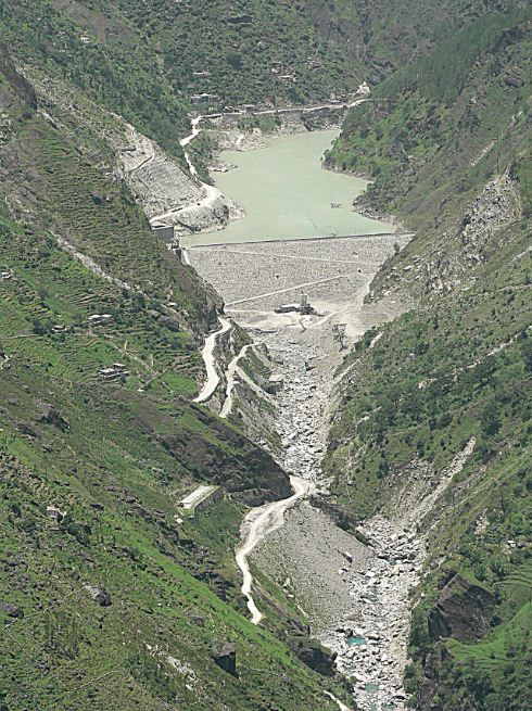
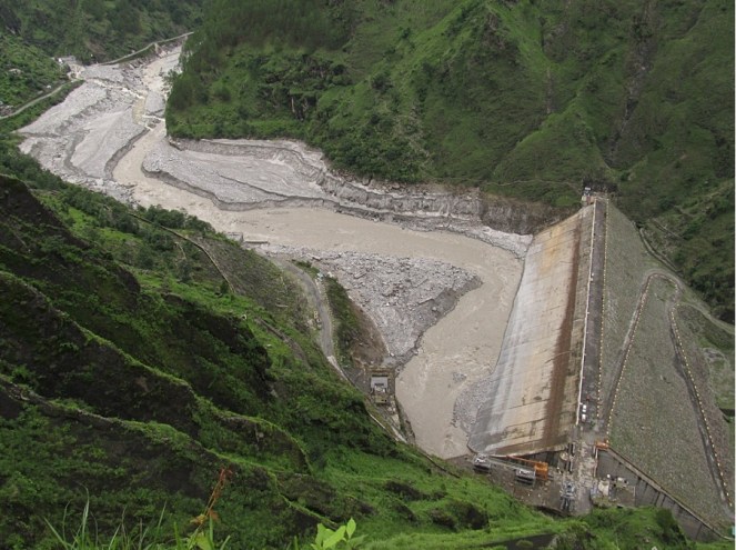
The Dhauliganga HEP is located on the Darmayangti river, re-christened the Dhauliganga  river, just a couple of kilometers upstream of the confluence with the Mahakali at Tawaghat. In these two kilometers, the rivers flows (twice a year when it is allowed to, for a few hours) down steeply to the confluence which it meets at right-angles. With the Mahakali already in spate, coupled with the sudden release of more than 6 million cubic meters of stored water (Gross Storage Capacity), plus the flow of the river in flood (steadily increasing from 398 cubic meters a second on 15th June), as well as millions of tonnes of bed-load boulders and sediment, the damage downstream is clear to see. If you look at the fresh scour-level on the banks downstream of the dam, it is in places more than 15 meters higher than the flood-level flow of the DhauliRiver. The river added thousands of tonnes of even more debris when, because of the flood level it reached, it tore through, plucking high at the talus-cones on either bank, and at every turn. At the confluence at Tawaghat, there must have been something of a back-flood for some time (a common flood phenomenon where the high-flowing main-stem creates a temporary water-dam), because the water-level seems to have risen very high, taking away the bridge that connects the entire Kuti valley and the trade route to Tibet,   tearing away almost the entire village-market complex at Tawaghat, and destroying the road as well. The flood waters had clearly reached the top of the road because of the deposition of river-sand on it. When I walked this section days later, the river was only less than a meter below danger mark. Even so, it was flowing about 12 meters below the road! Further downstream, the destruction was more serious.

In order to understand the magnitude of this flood event, I ask Joshi of NHPC for flow-data of the Dhauli river between the 12th and the 18th of June. He goes off for some time and returns with a sheet of paper that has hand-scrawled 6 hourly flow volumes from 12th June, but stops short at 15th June. All the flow volumes between the 12th and the 15th were below 150 cubic meters a box 1second (cumecs), and at 12 am, on the night of the 15th June it jumps up to 389.92 cumecs. This is just the start of the flood. Joshi seems to balk right here, and says that they have not received data for the 16th June yet (the day I speak to him was the 8th of July), and that he may get it after a week or so. And anyway, he says, the powerhouse was abandoned from the night of the 16thJune, so getting data beyond that would be out of question. It is clear that Joshi was unwilling to give me flow-data for the duration of the flood-pulse. He had only minutes before informed me of how automated the whole operation was, and that it was possible for them to even operate the power-house sitting in their Dobat office-complex itself. The real scenario will be clear when we get flow data for the 16th and 17th of June.

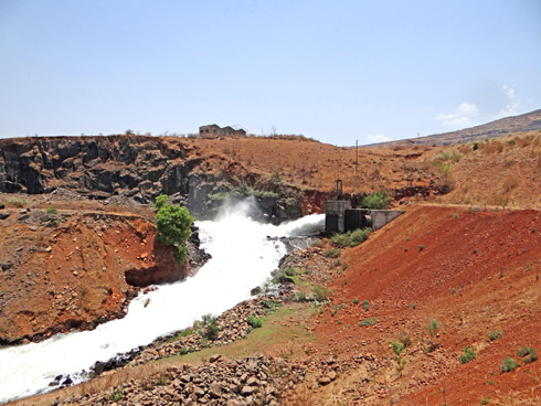
According to NHPC, the Peak Flood Design for the Dhauliganga HEP is 3,210 cumecs, at a return interval of 100 years. That is the flow volumes that the dam is designed to be able to take without damage, at flood levels expected at least every hundred years. It is unlikely that flow volumes had reached almost 10 times the flow volumes of the flood on the 15th June at the damsite (389.92 cumecs). NHPC gets its flow data from an automated level-gauge at the reservoir, so it did not require anyone to take readings manually, even prior to abandoning the station. If unprecedented levels had indeed been reached, then why had they held on to water in the reservoir right till the night of the 16th June?  Please see the accompanying photographs, of the dam reservoir, empty of water. You can see at least two levels of cut-away terraces. The lower ones are alluvial terraces, consisting clearly of coarser gravels and cobbles deposited by the flowing river. The higher terraces, more visible high on the upper true-left bank in the photo, are remnant lacustrine (lake-bed) terraces, consisting of finer silts and sand, deposited by the stilled waters in the reservoir when it was full. This was the highest point of sediment accumulation in the reservoir prior to being flushed out. Clearly, at least 45% the reservoir was full of debris and sediment before NHPC flushed it. And if you look at the brown line on the concrete face of the dam, you see the level that the reservoir was allowed to fill upto, marked by the ‘bath-tub ring’ of floating bark and woody debris stuck there after draining.

Joshi tells me that when a delegation of people from Nepal came to NHPC to talk about the possible role that NHPC’s sudden release of water might have had on the flood that devastated Khalanga bazar at Darchula, he had told them that to the contrary, the dam had saved Nepal from great damage. “See how much debris is still behind our reservoir!” This was bare-faced misinformation. There are two aspects being denied here. One, that great masses of debris were actually flushed out from the lower-end of the reservoir on the night of 16th June, leading to greatly increased flood levels as well as erosive potential downstream, especially on the Nepal bank at Darchula, which bore the brunt of flushed debris centrifuged on the curve. As is evident from the photo of the dam-site above, most of the debris that has been flushed, is from the front-end of the reservoir only. And two, that all dams and reservoirs, despite some being able to flush out debris from a section of the reservoir, do actually hold back a great deal of bed-load as well as suspended sediment in the upper end of the reservoir. They impede the very essential flow of sediment down to the oceans. Look now at the geometry of bed-load debris in the stitched photo. Distortions from the wide-angle lens apart, it clearly shows a gradual slope, and a filling up of the bed-rock channel to form a wide, sloping flood-plain. Had it not been for the dam, the bed-load would have continued to fill up the bed-rock channel downstream at about the same angle, slowing the entire flow of water and entrained debris. It would not have been washed down catastrophically all the way down to Darchula, without the force of an additional 6 million m³ of stored water released suddenly.

Emmanuel Theophilus (etheophilus@gmail.com)


[1]    NHPC never gives warning of sudden releases. There is a notice painted on a board at Tawaghat, the first river-side habitation downstream, that warns people not to go anywhere near the river, because water may be released anytime.

[2]    Kajima Construction Corporation Ltd of Japan, Daewoo Engineering and Construction Company of Korea, and Bauer Maschinen of Germany.

[3]    How a tail-race exit could be planned on the Ellagad stream which is very steep and unstable, full of debris from a service tunnel, and highly ‘flashy’, is indicative of poor design and of lax design approval mechanisms.

Assam · Dam Induced Flood Disaster · Dams · Expert Appraisal Committee · Hydropower

Lower Kopili HEP: Oustanding issues that must be resolved before EAC can consider the project

The Lower Kopili Hydro Electric Project(HEP) will be considered for TOR clearance in the forthcoming Expert Appraisal Committee(EAC) meeting on September 23-24, 2013. This project was first discussed in the 63rd EAC meeting held on 12-13th October, 2012. It was again discussed in the 65th meeting of the EAC held on 26-27th December, 2012 for approval of Terms of Reference (TOR) for the Environmental Impact Assessment (EIA). EAC had sent back the project proposal seeking additional information/clarification on several issues. There were several critical issues which were not raised by the EAC. We have made a submission to EAC pointing out issues which need urgent attention.

Background of Hydroelectricity Generation on Kopili River

The Kopili River: Kopili is a south bank tributary of Brahmaputra which originates in the Borail range mountains in Meghalaya at an altitude of about 1600 m and has a total length of 290 km up to its confluence with Brahmaputra. Its basin is bound by the Jaintia Hills in the west and the South Cachar and Mikir Hills in the east. Kharkor, Myntriang, Dinar, Longsom, Amring, Umrong, Longku and Langkri are its major tributaries in its upper reaches.

After entering Assam the Kopili separates the Karbi Anglong district from the Dima Hasao North Cachar Hills district up to its confluence with Diyung River on its right at 135 km. After the confluence with Diyung, Kopili flows into the Nagaon district in a north-westerly direction. The Jamuna River with a catchment of 3960 km2 flows to the Kopili at Jamunamukh. The river then flows in western direction, and further downstream, the Umkhen-Borapani River which rises in the Shillong plateau and drains an area of 2038 km2 joins Kopili at a distance of 254 km from the left. The Killing River, known as Umiam in its upper reaches draining an area of about 1445 km2, flows into Kopili from the left at about 280 km. The Kopili River finally flows to Kalang, a spill channel of Brahmaputra, near Hatimukh after traversing a distance of 290 km2. The total catchment of Kopili River is about 16,421km2.

Kopili HEP: The Kopili Hydro Electric Project (HEP) has two dams, one on the Kopili River and one on its tributary Umrang stream. This project was developed by NEEPCO (Northeast Electric Power Corporation Ltd.). The first dam with 66 m height on the Kopli River is known as Khndong dam and the second one with 30 m height is known as Kopili dam located at Umranso.  Water from the Khandong reservoir is utilised in the Khandong power station through a 2852 m long tunnel to generate 50 MW (2 X 25 MW) of power. The tail water from this powerhouse is led to the Umrong reservoir. The water from Umrong reservoir is taken through a 5473 m long tunnel to the Kopili power station to generate 200 MW (4 X 50 MW) of power. An additional 25MW was added to the Khandong dam in the Stage two of the Kopili HEP, making the total power generation 275 MW. Both Khandong and Kopili dams are concrete gravity dams. The first unit of this Kopili HEP was commissioned in March 1984. Additional unit under stage two was commissioned in July, 2004.

Proposed Lower Kopili HEP: The proposed Lower Kopili HEP is coming up in Boro Longku village in Dima Hasao district. The project is developed by Assam Power Generation Corporation Limited (APGCL). The Lower Kopili dam will be a concrete gravity dam with 70.13 m high dam wall. This project will also have two power houses and the first power house, or the main power house will have an installed capacity of 110 MW (2X55MW). An auxiliary Power House with an installed capacity of 10 MW (2×2.5 MW+1×5 MW) has been planned  at  the  toe  of  the  dam  for  utilizing  the  mandatory  releases  for  ecological purposes, making the total installed capacity 120 MW. The Head Race Tunnel(HRT) of the project will be 7.25 m in diameter and 3.6 km long. The total land required for this project will be 1577 ha out of which according to the revised PFR and Form-I 552 ha will fall under submergence. But the old PFR and Form-I had mentioned the size of the submergence area as 620ha. The  free flowing river  stretch  between  Full Reservoir Level  (FRL) of  Lower  Kopili  HEP  and  Tail Water Level (TWL) of upstream  Kopili  HEP  is  about  6  km.

The water available at Lower Kopili dam site will consists of the following components:

1.   Tailrace releases from Kopili Power Station (4 x 50 MW)

2.   Inflow from intermediate catchment between Khandong and Longku Dam site

3.   Spill from Khandong and Umrong Reservoir.

Projects in Cascade on Kopili River

Some Key Issues Requiring Urgent Attention

After thoroughly going through Pre Feasibility Report (PFR) and Form-I of the proposed Lower Kopili HEP we have found that following issues have not been adequately dealt with by the project authorities. Infact some of them have not even been mentioned at all. EAC should not give TOR clearance to the project without satisfactory resolution of these issues.

Dam induced Flood: Experiences of the people living in downstream suggest that floods have become more recurrent after construction of the dam. The Kopili dam has changed the character of flood in the river downstream for the worse. Before the construction of Kopili dam, floods occurred mainly during monsoon season. Increase in water volume due to heavy rains used to be the reason for flood. These were normal floods which occurred not more than two or three times a year. But after the construction of the dam, number of artificial floods occurring in a year has gone upto 5- 6 times. These floods mainly occurred from the month of August to the first one or two weeks of November. Government of Assam never made an attempt to investigate the source of these floods (this information is from a field visit done to the area). 

In the catastrophic floods of 2004, out of 140 revenue villages of Kampur circle of Nagaon district 132 were affected by floods with area of 135.12 sq. miles. Due to these floods 1,92,000 people were temporarily displaced. These floods also took the lives of 4 people. Even government had confirmed that the main reason for the devastation in these Nagaon and Morigaon districts was the release of the water from the NEEPCO’s Kopili project. The team that was deputed by the government found that water level of the Khandong reservoir went up to 727.70 meters against the FRL of 719.30 meters on 18th July 2004, which rolled down and led to catastrophic disaster. Flood release from the dam happened without prior warning and affected the whole valley. Kampur is one of the towns located in the downstream of Kopili dam where people were give only 2 hours to evacuate the area and move to nearby relief camps.  July 18 is less than midway through the monsoon and questions arise why was the dam allowed to be filled up so soon which had led to such disaster. Had the dam operations were conducted properly the disaster could have possibly been avoided.

The issue of flash floods in Kopili River was raised in the Assam state assembly. On 8th November, 2010 former Chief Minister of Assam Mr. Prafulla Kumar Mahanta, an MLA from Nagaon district made a call attention motion in the Legislative assembly on the issue flash floods in Kopili. He stated the NEEPCO is responsible for the flash floods in the Kopili River.[1] Then Water Resource Minister Prithvi Majhi in his reply accepted this claim by saying that “the government would take up the matter of providing prior warning before release of excess water with the NEEPCO authorities.”  From the above experiences of flood in Kopili River, it is clear that after the construction of the Kopili HEP (Hydroelectric Project) flood ferocity had increased in the downstream. In such situation construction of another dam in the immediate downstream of previous dam can worsen the flood scenario.

Besides, The Kopili reservoir of the Khandong dam is located at 82.5 km downstream from the origin of Kopili River. A major tributary Myntang with 512 sq kmcatchment joins Kopili at 86 km from origin[2]. This is one of the tributaries in the upstream of proposed Longku dam site. In rainy season excess of rains in the catchment of these streams can also lead to spillovers in the proposed dam itself. The PFR does not look into the cumulative impact of the operation of the two dams on the downstream riverine area.

Spillway Capacity Inadequate at Lower Kopili HEP: As per the PFR, the design spillway capacity of the proposed Lower Kopili project with catchment of 2106 sq km is 16110 cumecs. Compare this with the spillway capacity of the upstream Khandong dam on the same Kopili river with catchment area of 1256 sq km being 15471.3 cumecs. It is clear that the design spillway capacity of the proposed Lower Kopili Project is inadequate.

Acid Contamination due to Opencast Mining threatens Viability of Lower Kopili: In the item 9.9 of the Form-I it has been mentioned that the acidic mine discharge in the upper reaches of the Kopili catchment is posing serious threats to the existing Kopili HEP. The PFR states “The identified acid mine discharge has been reported to cause constant erosion/ corrosion of critical hydropower equipments leading to frequent outages of the power plants under Kopili HEP.” The minutes of 9th TCC (Technical Coordination Committee) & 9th North East Region Power Committee Meetings held on 11-12th August, 2010, stated “The Kopili HE Plant has faced an extraordinary and unprecedented situation owing to acidic nature of the reservoir water. Prima facie, the acidification of the reservoir water is caused due to unscientific coal mining in the catchment area as revealed by study through GSI, NER, Shillong. The increased wear and tear on the underwater metal parts of the Plant due to corrosive action of the acidic water has led to the increase in the number of breakdowns.” The minutes also mentioned “It is pertinent to mention here that, although massive repairing work has been carried out by NEEPCO as temporary measures; an integrated, interdisciplinary approach for preventing / tackling acidification at source must be opted for survival of the Plant.” The acidic contamination due to open cast mining is such that no living organisms could be found in the downstream of Kopili river up to Kheroni.[3] The situation is quite alarming as the PH value of the water has come down from 5.5 to 3.2 due to acidic contamination which is unfit for human consumption. State Power Minster was very much aware of the situation and expressing concerns over this he had asked the center to take up this issue with Meghalaya.[4] The PFR should have given detailed account of implication of this on the proposed Lower Kopili HEP and further downstream, but has not done that.

PFR overlooks Kopili Fault Line: The PFR of the proposed Lower Kopili HEP does not mention about the Kopili fault line[5]. In recent studies done in the Kopili river basin it has been found that the Kopili fault extends  from  western  part  of  Manipur  up  to  the  tri-junction  of  Bhutan,  Arunachal Pradesh  and Assam, covers  a  distance  of about  400 km. During the last 140 years, the Kopili fault has experienced 2 earthquakes of magnitude greater than 7 in R.S., three of magnitude 6 to 7 in R.S. and several of magnitude 4.5 to 6 in R.S.[6]   The study concludes that the North East region, more specially the Kopili Fault area is a geologically unstable region, surrounded by faults and lineaments and seduction zones in the east.  But the PFR of Lower Kopili, overlooking this issue states that there are only two minor faults in this area and both of them are much beyond the project area. This clearly wrong and misleading on the part of Lower Kopili PFR.

Besides, some of the EAC statements are not complete and stand in contradiction to each other. The EAC said that as the site specific seismic study had been completed by IIT Roorkee and considered it appropriate for 120 MW project. But it also mentioned “The project specific geo-morphological and neo-tectonic mapping has not been done so far. As the project area falls under the active seismic zone where the Disang-Naga Thrust and Dhauki fault merge which triggers high seismic risk, the proponent is to monitor the MEQ studies by installing a 3-4 seismograph network for a period of one year.” When EAC is aware of these site specific details, allowing an additional big dam in the area will only to increase disaster potential in the area. EAC needs to keep this in mind while considering this new dam.

Issues Tribal Land Relations: In the item 2.1 of the Form 1 the project authorities have stated that the 620 ha that will be submerged due to this project consists of medium to high density vegetation, scrubs open and barren land etc. But Dima Hasao people have expressed their fears of not getting proper rehabilitation.[7] The project seems to ignore this fact in the form 1. There can another reason also for the stating the submerged land as government land because the land holdings may not same as the ‘patta’ lands.[8] Besides, the area which has been considered for the construction of the dam is inhabited by Dimasa people who mainly depended on the system of shifting cultivation.[9] It is to be noted that in shifting cultivation there a cultivator cannot exercise permanent ownership over the land.

Defining ‘Other Forests’: The project as stated in item 1.1 of form 1 will also submerge 65 ha cultivation land. In the same item it is mentioned that an area of 585 ha will be submerged and this area has been mentioned as ‘other forests’. But the Form 1 did not define what this ‘other forests’ are or what they consists.

Impact on the Local People: In a memorandum submitted jointly by the Karbi Students’ Association (KSA), Sominder Kabi Amei (SKA) and Karbi Nimso Chingthur Asong (KNCA), to the State Power Minster Mr. Praduyut Bordoloi, the association demanded first preference in terms of employment should be given to the locally affected people. But the track record of dam building companies is very poor in this regard. The local people did not get promised employment and other benefits the in the Kopili project which came up in 1970s, 1980s and 1990s. On 20th March 2012, the Dimasa Students’ Union, Dimasa Welfare Association, Karbi Students’ Association and Sengia Tularam Club called for a 48 hours Umrangso bandh seeking “60 per cent of technical and non-technical posts in the project should be reserved for the local tribal populace, 100 per cent reservation for local tribal youths for Grade III and Grade IV posts, free electricity for locals, free treatment facilities in NEEPCO-run hospitals and so on.”[10] This is very crucial issues but surprisingly it finds no place in the PFR document.

Why the size of forest area significantly reduced: In the revised Form I and PFR, submitted on 23 August 2013, Section 1.1 mentioned that out of 1577 ha which is the total land required for the project, 552 ha will fall under submergence and 340 ha forest land will  be submerged in the reservoir. But the previous Form I and PFR, submitted on 14th November 2012, stated in the same section that the land falling under submergence and land converted into reservoir area is same i.e. 620 ha. The revised document does not give any rationale for reducing size of submergence area and reservoir area. It is also surprising to note that in the revised document, under the section “Impacts due to damming of river” in page 55, the old figures of submergence has been reiterated – “The  damming  of  river  Kopili  due  to  the  proposed  hydroelectric  project  in  creation  of  620  ha  of submergence  area.” So the new documents submitted in Aug 2013 have serious contradictions.

Issues Need to be Included in EIA report

Since several critical issues were not included in the previously submitted document, we have listed out the following issue which should be included in the Environment Impact Assessment (EIA) study of the proposed Lower Kopili HEP. Without detail analysis of all these issues EIA cannot be considered as complete.

Downstream Impact Assessment:  Downstream impact assessment is a burning problem in Assam. The state has already witnessed huge protests against dams due to lack of proper downstream impact assessment. In case of proposed Lower Kopili HEP, the EIA document should do a proper downstream impact assessment. In order to do a thorough downstream impact assessment, the EIA will have to go beyond the 10 km radius and assess the full downstream area. In case of Lower Kopili, going beyond 10 km downstream becomes all the more significant because major part of the Kopili river basin is in the downstream of the dam. The downstream impact assessment should specifically focus on the impacts of the dam on fisheries and livelihood of the people who are dependent on fisheries, change in character of flood and impacts thereof, change in sedimentation and impacts thereof, change in geomorphological issues, change in groundwater recharge, among others. The EIA should find which section of people will be affected the most by the dam and how to compensate those people.

It has been reported that bank erosion by the Kopili River has increased after the construction of the Kopili dam. The EIA report of Lower Kopili HEP, should do an analysis to find what will be impacts of the new project on river bank erosion.

Impacts Peaking Power Operations: The EIA should do a detail assessment of impacts of peaking power operation during non-monsoon months. Due to peaking power generation in non-monsoon months the river stretch downstream from power house will have very little water for most hours of a day with sudden flows in the river only for a few hours. This flow fluctuation leads to many severe impacts including on aquatic bio-diversity, on safety, on river bed cultivation, on erosion, among others. This has severe socio economic impacts along with issues of safety of the people and their livestock in this stretch of the river. Therefore the EIA should do a detail assessment of impacts of peaking power generation.

Assessment of Optimum Reservoir Operation: The EIA should do an assessment to prepare an optimum reservoir operations plan for the project in order to minimize the downstream impacts if a disaster occurs. It is also highly recommended that the local people should be made a part of the reservoir operations process. Then only the dam authorities can be expected to be more responsible to in reservoir operations.

Impacts of Silt Management operations: The EIA should include detail analysis impact of changing silt flows downstream from desilting chamber, from silt flushing in monsoon, on the downstream areas. The EIA study should give detailed account of how the silt from the dam will be flushed out annually and what will be the impact of this in the downstream. The EIA should also include how the desilting chamber will be operated and what will be its impacts.

Detailed and Thorough Options Assessment: The EIA should do a thorough options assessment for the project. There can be several other cost effective options for power generation in that area and options assessment should look into al those.

Here we can take the case of solar power. A recent example of proposed 1000 MW solar power generation in Rajastan[11] has showed that for 1 MW installed capacity only 2 Ha of land is required and the cost per megawatt installed capacity will be 7.5 crores and electricity will be provided at Rs 6.5 per unit. Another proposed 25 MW solar power project in Assam[12] has similar figures.

At this rate, for a 120 MW (the target capacity of the proposed Lower Kopili HEP) solar power plant, the land required will be 240 ha. But for Lower Kopili HEP the land required is 1557 ha of land out of which nearly 900 ha will be used for the project even if we subtract 680 ha projected to be used for compensatory afforestation. This implies that for 1 MW installed capacity for the proposed dam the land requirement will be about 7.5 ha, about 3.75 times the land required for solar project of same capacity. Besides, the total cost for the Lower Kopili project is expected to be Rs. 1489.64 crores implying cost per MW installed capacity will be Rs. 12.41 crores, compared to Rs 7.5 cr for solar plant. Even if we were to put up 240 MW installed capacity of solar project, it would require 480 ha land, will not have impacts on the river, on people’s livelihoods, on forests, on climate change, and so on.

Increased Costs: It is important to note here that EAC in its 65th meeting in March 2013 discussing this projects had noted “In  comparison  to  other  HEPs  being  examined  recently,  the  cost  per  unit  of installed capacity of this project is almost double!” and this was said when the cost per megawatt installed capacity was Rs. 9.79 crores. Now in the revised document, the cost has gone up further to Rs 12.41 cr, the project proponent need to explain this further escalation from the earlier already high cost.

Groundwater Depletion in Downstream areas: People in the downstream of Kopili dam have reported that there has been depletion of groundwater in the downstream areas of Kopili dam. From a field visit done in the downstream areas of Kopili dam, it was reported that the ground water level at certain areas had reduced to 140 feet. River like Borapani, Kopili and Nisari dry up in the winters affecting the winter cultivations. Besides, wetlands which are known as Beel or Duba locally have disappeared. The reduction in groundwater can also be due to reduced groundwater recharge due to the dam. Impact of the dam on groundwater recharge should be a part of the EIA study.

Impacts of Tunneling and Blasting: The EIA should analyze the impacts of tunneling and blasting as these activities can increase in risk of landslide and disaster in a hilly area. Blasting in hilly area also will have impacts on water and people. These impacts should be thoroughly assessed by the EIA of the proposed project.

Impacts of Mining: The project will require large quantities of sand, coarse and fine granules and boulders. These are likely to be mined from the nearby areas. The EIA should include a study on the impacts of mining on the people as well on the local environment. Mining for the project will be done in the nearby areas and it will have severe impact on people as well as on the river, bio-diversity, hills, flora-fauna and aquatic bio-diversity etc. The study on the impacts of mining should include all these issues.

Impacts of Backwater Effects: The PFR of proposed Lower Kopili HEP states that Maximum Water Level (MWL) of the river is 229.60m where as the FRL of the reservoir is 226.0m. The MWL is thus 3.6m higher than FRL and this will have serious back water effects during the times of monsoon. The EIA must do an assessment of the submergence at MWL level and backwater effect measured at MWL and follow it up with an impacts analysis.

Detailed analysis about the existence of wetlands, watercourses and other water bodies: The revised PFR in page 17 under section ‘Environment Sensitivity’ states that there are no wetlands, watercourses and other waterbodies reported within the 15 km of the project. This statement seems incorrect. The EIA should do a detailed and thorough analysis regarding the existence wetlands, watercourses and other water bodies within 15 km of the project site.

 Impacts of Climate Change: The EIA of the proposed Lower Kopili dam should do a study of  possible impact of the climate change on the dam as well as on the Kopili river. Besides, it should also include the impacts of the dam on adaptation capacity of the local people.

Smaller Size Documents should be Uploaded for Public Dissemination: The EIA and other documents which would be uploaded on the internet should be about the size of 10 MB or less. The Revised Form I and PFR which uploaded on the MoEF website was 114 MB and it was difficult to download such a huge document even in a metropolis. These heavy documents will nearly be impossible to download from a small town or a village. The MoEF should insist from projects proponents that PP should be careful about this and should reduce the size (less than 10MB) documents for uploading from next time.


Parag Jyoti Saikia

with inputs from Himanshu Thakkar and Pooja Kotoky

Email – meandering1800@gmail.com

South Asia Network on Dams, Rivers & People (https://sandrp.in/https://sandrp.wordpress.com/)


[2] Patowary, A., “The Kopili Hydroelectric Project, Downstream People Rise in Struggle” published in “Water Conflicts in Northeast India – A Compendium of Case Studies” edited by Das, Partha J. et. all, 2013

[5] Mahanta,  K. and et all (2012): “Structural Formation & Seismicity of Kopili Fault Region in North-East India and Estimation of Its Crustal Velocity” International Journal of Modern Engineering Research,Vol.2, Issue.6, Nov-Dec. 2012 pp-4699-4702

[6] ibid

[8] It is to be noted that in many of the tribal areas of Assam and India’s north eastern states, the tribal law of land is community of ownership of land and there are no government ‘patta’ system.

Dams · Ministry of Environment and Forests

Open letter to Rahul Gandhi as he lays foundation stone of Parwan Dam: A Dam meant for thermal power projects

Reports[1] indicate that Congress leader Rahul Gandhi is to lay foundation stone for the controversial Parwan Irrigation Project in Jhalawar district in Rajasthan (see the map above, taken from Down to Earth), before speaking at public meeting in Baran district on Tuesday, Sept 17, 2013. Detailed analysis of official documents and other reliable accounts indicate that this unnecessary dam is seemingly being pushed to supply water to some of the proposed thermal power projects in Baran and Jhalawar districts.

Image

The project will require 12248 ha of land including submergence of massive 9810 ha of land as per conservative government estimates, displacing about 100 000 people[2] from at least 67 villages of Baran and Jhalawar districts in Hadauti region of Rajasthan. It will require at least 1835 ha of forest land, and will affect at least 2 lakh trees only on this forest land, lakhs of trees on non forest land will also stand destroyed. Most of the 1.31 lakh Ha of land in Baran, Jhalawar and Kota districts that is supposedly to get irrigation is already irrigated. These districts have average rainfall of 842 mm (Baran[3]), 923.5 mm (Jhalawar[4]) and 804 mm (Kota[5]), which is high by Rajasthan standards. If there is adequate harvesting of this rainwater, groundwater levels would certainly rise and remain sustainable with appropriate cropping pattern. This has happened in neighbouring Alwar and Jaipur districts.

This Rs 2000 crore dam with huge impacts is certainly not required for this purpose.

From all accounts, in reality the dam seems to be pushed for thermal power projects like the 1320 MW Kawai coal based thermal power project of Adani[6], 1320 MW coal based Chhabra[7] thermal power project of Rajasthan Rajya Vidyut Utpadan Nigam Ltd and the 330 MW gas based thermal power project of RRVUN at the same location. Very strangely, these projects applied for environmental clearance based on water supply from Parwan dam, even when Parwan dam does  not have all the required statutory clearances, and when work its yet to start. The MoEF should have refused to sanction these thermal power projects before Parwan dam was in place.

This action of the MoEF speaks volumes about poor environmental governance due to which the TPS were cleared based on water from a project that is yet to see even foundation stone or all necessary clearances! The allocation for thermal power projects has increased[8] from earlier 40 Million Cubic meters (MCM) to 79 MCM to 87.8 MCM and this is likely to increase further considering these allocations did not take into account the transmission and evaporation losses.

Manipulated clearance process In fact the Parwan dam still does not have all the necessary statutory clearances. A quick look at the way Parwan got various clearances:

Þ    Environmental Impact Assessment From the minutes of the 40th and 45th meetings of the Expert Appraisal Committee on River Valley Committee held in August and December 2010 it is clear that the EIA of the project did not have: Full social impact assessment, Full R&R Plan with Categories of Project affected persons and land for each category, Proper Dam break analysis, proper command area development plan with cropping pattern or necessary irrigation intensity (Only 14% kharif irrigation intensity provided as noted by EAC) and drainage plan, muck disposal plan. The basic facts in the EIA were wrong and the EAC should have rejected the EIA.

Þ    Contradictions in EIA The EIA is full of contradictory information. For example it says the forest land coming under submergence is 1608.59 ha when the FAC form A[9] says that submerging forest land is 1731.48 ha. This is a very big difference by any standards.

Þ    R & R Plan Firstly, there is such huge difference in the figures of displaced and affected people in various documents; it is clear there has been no credible social impact assessment. For example, EAC notes that 2722 houses to be submerged, 3002 (2142 in FAC factsheet in 0413) families to be affected, of which 461 tribal families. No R&R for non tribal families, which is completely unjust. Even for the tribal families there is no adequate provision of agricultural land. FAC sub committee accepts: “Most of these families do not belong to the notified Scheduled Tribes and also do not have any documentary evidence to prove that they are in possession of the forest land for a continuous period of minimum 75 years.” So most of the people will not even be eligible for resettlement or rehabilitation.

Þ    How many people are affected? About 1401 families with population of 8650 persons will be displaced fully while 741 families with 4172 persons will be displaced partially. The ST population comprises 340 families with population of 1524 persons fully displaced and 121 families population 882 persons are partially displaced. However, independent sources are saying that the project will affect more than a lakh of people. This is a huge difference. Track record of past projects shows that official figures are always gross under estimates.

Þ    EAC recommendation However, even when the responses to EAC’s fundamental concerns were not available, EAC recommended clearance to the project in December 2010. This showed how the EAC basically works as a rubber stamp.

Þ    Environment clearance After EAC’s recommendation, the MEF is supposed to issue Environmental clearance. However, a visit to MEF website[10] on September 16, 2013 shows no information about clearance to the project. We learn from other sources that the MEF issued clearance to the project in 2011, but since it is not put up on the MEF website as required under EIA notification and NGT orders, the project will remain open to legal challenge with 30/90 days of MEF putting up the clearance letter on MEF website.

Þ    Wildlife clearance The Standing Committee of the National Board of Wildlife in its 22nd meeting[11] held on April 25, 2011 considered the project. This was the infamous meeting[12] chaired by the then Union Minister of state (Independent Charge) of Environment and Forests Jairam Ramesh pushed 59 projects in two hours (average two minutes per project). He reportedly[13] said later that this was done under pressure, but the damage was done.

Þ    Dr M.K. Ranjitsinh[14] and Dr Divyabhanusinh Chavda[15] submitted dissent notes, but the minister had predetermined objective and did not listen to any argument. The NBWL decided to clear the project even without knowing if the Shergarh  wildflife sanctuary will be affected, how much water the downstream river will need, what will be the impact of the project on Jawahar Sagar Sanctuary, Rana Pratap Sagar Sanctuary or Chambal River Sanctuary or the project even had done basic options assessment or impact assessment.

Þ    Location with respect to Shergarh WLS One of the key issues about this project is the location of the project with respect to Shergarh Wild Life Sanctuary. As noted by the FAC sub committee, the Parwan Doob Kshetra Hitkari and Jangal Bachao Samiti has been saying that the dam site is right inside the Sanctuary. However, if the project were to affect the WLS, it would require a Supreme Court clearance. To avoid this, manipulations have been going on.

The Site Inspection Report[16] of Forest Advisory Committee noted this issue and conducted a joint inspection in June 2012. The SIR said after this exercise that the proposed dam is 150 m in the upstream of the boundary of the WLS. However, the Parwan Doob Kshetra Hitkari and Jangal Bachao Samiti have contested this conclusion and said there was manipulation in this exercise.

But the EIA of the project, as noted by the 40th and 45th EAC meeting said that the project is five km away from the Shergarh WLS (this itself shows how poor is the EIA and how poor is the appraisal by EAC. Shockingly, even the Environment Clearance letter of 2011 also reportedly says that the project is 5 km away from the WLS, another reason why the EC will remain open to legal challenge.) In June 2013 there was another attempt at resolving this dispute, but again due to heavy rains could not be resolved. Funnily, the NBWL, which should be most concerned about this issue, has shown no concern. Until this issue is satisfactorily resolved, the project cannot go ahead, it will remain open to legal challenge.

Þ    Recommendation of 25 cusecs release The NBWL condition that 25 cusecs (cubic feet per second) water should be released for the environment is not based on any assessment of water requirement for the river and biodiversity in the downstream, since such an assessment has never been done. It seems like another manipulation, based on the fact that Shergarh weir, 10 km downstream from the dam site, has storage capacity of 16 MCM, which is equal to release of 25 cusecs water!

Þ    Gram Sabha resolutions The FAC factsheet[17] agrees that there are contradictory gram sabha resolutions, one set against the project and another submitted by the project authorities in favour of the project. The resolutions submitted by the opposing committee, which is without vested interests, is likely to be correct. There should be an inquiry about the correctness of the gramsabha resolutions by an independent body.

Þ    Forest Advisory Committee The FAC considered the project in its meetings in Sept 2012 and April 2013 and recommended clearance in April 2013 meeting when all the fundamental issues remained unresolved.

Þ    FAC sub-committee A sub committee of FAC visited the project in March 2013. Their report accepts a number of serious anomalies. For example, it says: “FAC sub committee report says: “It (is) a fact that a major part of the command area of the project is presently irrigated by using tube wells… Though there is no mention in the EIA report and other documents, about 79 MCM water from the dam is proposed to be utilized for 1,200 MW and 2,520 MW thermal power plants being constructed at Kawai and Chhabra respectively, in Baran district… It has been accepted by the project proponent that approach road to the historic Kakoni temple will be submerged. Submergence of the approach road will hinder free movement of devotees to the said temple, which may result in public resentment.”

Þ    Forest Clearance After the FAC recommended forest clearance for the project in April 2013 in questionable circumstances, the MEF is supposed to issue in principle forest clearance and than after fulfillment of conditions in the in-principle clearance, it can issue final clearance. A perusal of the MoEF FC website[18] on Sept 16, 2013 shows that the site does not display any of the clearance letters. Our letter to the concerned MoEF officers on Sept 15, 2013 remains unanswered. We came to know through independent sources that in principle forest clearance has been issued in middle of August 2013, final forest clearance will take a long time.

Þ    Compensatory Afforestation Plan Full plan and maps of CAP have not been submitted, says FAC factsheet. It is not even known if the land for CA is free of encroachment, the DFO says it will be ensured when the possession taken, as reported in Factsheet in April 2013. CA land is in 32 villages in at least 32 pieces, the DFO has not even visited all the lands to ascertain if it is suitable for CA and yet DFO has given certificate that it is suitable for CA. This seems like typical case where CA has no chance of success as noted by CAG audit report on CA in Sept 2013. It is completely illegal of CCF, PCCF, state forest department, FAC or MoEF to consider the project without full CAP with all the required details verified on ground.

Þ    CWC clearance The Central Water Commission’s Technical Advisory Committee is supposed to clear all major irrigation projects. This TAC appraisal is supposed to happen only after all the final clearances are given as TAC recommendation is the basis for Planning Commission’s investment clearance. Since the Parwan project does not have the final forest clearance, it cannot be considered by the TAC of CWC. However, we learn that on Friday, Sept 13, 2013, TAC met and cleared the project.

Þ    Planning Commission Investment clearance Project cannot have the Planning Commission Investment Clearance since it does not have all other clearances in place. Without this clearance no funds can be allocated for the project from state or central plans.

Þ    Big irrigation projects not delivering As even Planning Commission and CAG has noted and as SANDRP has been showing through analysis for so many years, since 1992-93, net irrigated area by Major and Medium Irrigation Projects at National level has not seen any increase. There is little sense in spending massive amounts on such projects without understanding this reality. We hope Planning Commission, CWC, Rajasthan government and people concerned with this issue will take heed of this. Unless of course, if the intention is to create reliable reservoirs of water for thermal power projects, as seems to be case here, while pushing projects in the name of irrigation for Rajasthan farmers.

What all this means is that Rs 2332.52 crore project with Rajasthan’s fourth largest reservoir (after Bisalpur, Rana Pratap Sagar and Mahi Bajaj Sagar) is being planned without a proper appraisal or legally supportable clearances. Bull dozing ahead with such a  project which has huge social, environmental and economic costs is not only bound to keep it open to agitations, legal challenges and delays, but is also not likely to have justification in public eye. It can even be politically counter productive. Nehruvian era of trying to win elections through such so called temples of modern era is gone, and our politicians need to learn this fast.

It is hoped that better sense prevails and Mr Rahul Gandhi will ask the project to go through due process rather than laying foundation stone of this controversial project that has more questions than answers.

Himanshu Thakkar (ht.sandrp@gmail.com)

South Asia Network on Dams, Rivers & People (https://sandrp.in/)

END NOTES:


[12] http://articles.timesofindia.indiatimes.com/2011-09-30/india/30229554_1_clearance-process-nature-conservation-foundation-nbwl: ““The NBWL members note that in their last meeting during Jairam Ramesh’s tenure as environment minister they were forced to clear most of the 59 proposals to start projects in protected areas – wildlife sanctuaries and national parks – in only two hours… Yet another fact of the same meeting was that 39 clearance proposals were received only two days prior to the meeting leaving very little time, and no working day, for the members to even glance through the proposals.” The NBWL members who have signed the letter include Biswajit Mohanty from the Wildlife Society of Orissa, Asad Rahmani of the Bombay Natural History Society, T R Shankar Raman of the Nature Conservation Foundation, Bivabh Talukdar of Aranyaak, M K Ranjit Sinh, Divyabhanusinh Chavda, Brijendra Singh, Valmik Thapar, Prerna Bindra, Bittu Sehgal, Mitali Kakkar and Uma Ramakrishnan.”

[13] http://www.sanctuaryasia.com/magazines/commentary/5903-condemned-by-government-policy.html#sthash.otGYIc9L.dpuf: “Jairam Ramesh later made public the fact that such clearances were “under pressure”.”

[14] “The Parvan major irrigation project, Rajasthan, which will submerge 81.67 sq.km. of the Shergarh Wildlife Sanctuary and what is more, will result in the destruction of approximately 186443 trees, in a tree deficit State like Rajasthan. Furthermore, even though 25cusecs of water is proposed to be continuously released into the Chambal from the proposed dam, this project will result in a major diversion of water from the Chambal, which has already been identified as deficient in water flow to support the last viable populations of the endangered Gharial and the Dolphin, in the April 2011 report prepared by the Wildlife Institute of India at the instance of the MoEF. The report specifically recommends that no further diversion of water from the Chambal should take place if the future survival of the endangered aquatic species mentioned above, is to be secured. There is also no EIA of the project, with regard to the impact upon the aquatic life and ecology of the downstream Jawahar Sagar Sanctuary, Rana Pratap Sagar Sanctuary and the National Chambal Sanctuary”.

[15] “With regard to Parvan major irrigation project in Rajasthan, please record that I had pointed out at the meeting that nearly 2 lac trees need to be inundated/chopped for the purpose. Though I did not mention it then, I feel very strongly that proper EIA of the project must be done.”

Dams

Damocracy: “The world is killing its rivers!!”

Damocracy: “The world is killing its rivers!!”

As the film ‘Damocracy’ will be featured in the upcoming travelling International Film Festival on Water “Voices from the Waters” in Bangalore on 30th August 2013, we thought it timely to reblog our earlier blog on the film.

Himanshu Thakkar from SANDRP will be delivering a keynote address at Voices from the Waters on ‘Governance of Rivers in India’.

More details about the festival and the program:

http://www.goethe.de/ins/in/bag/ver/en11456064v.htm

Dams

CAG blows the lid off Massive irrigation scam in Andhra Pradesh


Summary points:

  • As on March 2012, Rs 80,000 crores spent on the projects under Jalyagnam, which was launched in the year 2004 by the then CM Rajshekhar Reddy, involving 86 projects involving cost of over Rs 1.86 lakh crore.
  • Almost all test checked projects were taken up and contract awarded without obtaining necessary clearances such as investment clearance (24 projects) from Planning Commission, forest clearance (21 projects) and environment clearance (18 projects) from Ministry of Environment and Forests; in principle clearance (16 projects) from CWC and R&R clearance (14 projects) from Ministry of Tribal Affairs.
  • Out of 74 irrigation projects, 31 were Lift Irrigation Schemes. The power required for these schemes amounted to nearly 54.43 percent of total Installed Capacity of the state and around 30.93 percent of total consumption of the state.
  • Audit scrutiny revealed that state government was yet to approve the draft plan for R&R of over 50 percent of displaced from 546 villages. Out of 281 villages for which the draft R & R plan is yet to be submitted, 206 villages pertain the controversial Polavaram project.
  • CAG noted that while the state government show an extra ordinary commitment in expediting the task of awarding the contract for Spillway (in March 2005) and ECRF dam work (in August 2006) for Polavaram project, it had not even initiated the socio-economic survey of the submergence zone and not yet identified the PAFs.
  • Some of the contractors garnered most of the work packages, largely through cross-formation of Joint Ventures amongst themselves. CAG found several flaws in tendering process such as, awarding contract on single tender basis, keeping qualification criteria fixed for empanelment of contractors at less stringent levels etc.

Jalyagnam, the most ambitious irrigation scheme of Andhra Pradesh has come under severe indictment in a recent performance audit carried out by CAG of India. The report got tabled in Andhra Pradesh assembly on June 21st, the last day of the budget session. The program comprised 86 projects (44 major, 30 medium, 4 flood banks and 8 modernisation works) and was estimated to cost Rs 1.86 lakh crore. While 12 under implementation projects (with an approved cost of Rs 2139 crore) were brought under Jalyagnam with an express aim of expediting their completion, the rest of the projects got sanctioned between 2004-’05 and 2008-’09. The programme aimed at extending irrigation in an ayacut of 97.40 lakh acres and stabilise another 22.53 lakh acres of existing ayacut in parched and drought prone areas of Telangana and Rayalseema. It also promised to provide drinking water to 1/4th of the state’s population and generate 2700 MW of power.

Concrete mixer machine worth Rs 7 Crores Photo:Anil Kumar

CAG audits for Andhra Pradesh have been reviewing irrigation projects in Andhra Pradesh every year. During the period 2004-2010, it had examined 18 irrigation projects. Almost all of those projects formed a part of Jalyagnam and those audit findings are under discussion by Public Accounts Committee. Those earlier audit reports have raised mainly two concerns: i) the need for building safeguards in the EPC (i.e. Engineering, Procurement and Construction) mode of contracts with regard to variation in scope, specifications, design etc. and ii) the impact of non-acquisition of land and non-obtaining statutory clearances from CWC, MoEF and MoTA before awarding the contracts.

CAG carried out performance audit of 26 out of 74 major and medium irrigation projects, involving a capital outlay of Rs 1.43 lakh crore, taken up under Jalyagnam during June – December 2011 with a focus on irrigation benefits. As on March 2012, Rs 61,498 crore were spent on these projects. Some of these 26 projects had also come audit scrutiny earlier as individual projects or as part of performance audit of AIBP and Godawari Water Utilisation Authority. Those audit findings haven’t been repeated in the present report.

Audit scrutiny of project related documents around feasibility issues revealed that many projects were taken up without adequate planning on ensuring the availability of water and power (in the case of Lift Irrigation Shcmes), and inadequate delineation of the targeted ayacut in some cases. It was especially so, in respect of projects on river Krishna and Pennar, where the water required for successful implementation of the projects is far above the quantity available in these two river basins. The state government was conscious of this aspect and hence made a claim that it proposed to utilise the surplus/ flood flow in the two river basins. CAG audit observation noted that there was evidence in the records made available to audit that the flood data of these rivers were analysed to assess the average number of days that flood flows are available annually. There was also no uniformity in the number of flood days adopted for the designing of the projects that were supposed to use flood flows of Krishna.

National Park Area W Godavari District Photo: Anil Kumar

Where is water for the projects? CAG cites an opinion expressed by an expert committee constituted by the state government in July 1997, to examine the feasibility of implementing Galeru Nagari project. This expert committee had stated at that point almost 15 years ago that the number of flood days in Krishna was only 30 per annum that too with only 40 percent dependability. Examined alongside this observation, some of the projects taken up on river Krishna are not viable and this is corroborated by the fact that CWC has returned the project proposals of Galeru Nagari, Veligonda and Srisailam Left Bank Canal projects to state government, stating that the state government had failed to establish clear and firm availability of water on a long term basis for these projects. CAG audit scrutiny also underlined a Planning Commission stipulation that all projects that have inter-state ramifications should be cleared by CWC, but state government had not obtained for these projects as of September 2012. CAG also noticed that there was no evidence in the records produced for audit to show that the proposals in respect of Gandikota-CBR lift scheme and CBR Lingala canal were sent to the CWC at any stage for approval.

Contracts before statutory clearances Not only was it an issue of an abysmally poor planning of Jalyagnam projects, audit scrutiny revealed that four projects were taken up without even feasibility studies and another 11 projects were taken up without preparation of Detailed Project Reports. CAG’s audit scrutiny also revealed that almost all test checked projects were taken up and contracts awarded without obtaining necessary clearances such as investment clearance (24 projects) from Planning Commission, forest clearance (21 projects) and environment clearance (18 projects) from MoEF, in-principle clearance (16 projects) from CWC and R&R clearance (14 projects) from MoTA. The much touted Jalyagnam had clearly bulldozed its way through the environmental regulation regime. It would be informative to find out if Planning Commission, CWC, MoEF and MoTA ever tried to engage the Andhra Pradesh state government to abide by the laws of the land. If this is not an example of brazen disregard for laws unleashed by development intoxication, where else shall we look?

As per annexure 3.1 in the audit report even as of July 2012 the following projects had not received Forest Clearances even as contracts for works on the same were awarded for quite some time now: Uttar Andhra, Galeru Nagari, Somasila Swarnmukhi Link Canal, Somasila Project, Rajiv Dummugudem, Pranahita Chevella, Dummugudem NS Tail pond, Telugu Ganga, Handri Neeva, Veligonda, Komaram Bheem, Kanthanapally, Devadula and Yellampally.

The same annexure states that following projects had not received Environment Clearance as of July 2012: Venkatnagaram, Uttar Andhra, SomasilaSwarnamukhiLinkCanal, Gandhikota – CBR Lift, CBRLingalaCanal, Pranhita Chevella, Dummuguddem NS Tail pond and Kanthanpally.

55% of AP power for Lift Irrigation Schemes? Out of 74 irrigation projects, 31 are Lift Irrigation Schemes. The power required for these projects, taken up over the river Krishna and Godavari, works out to be nearly 54.43 percent of total installed capacity of the state, and around 30.39 percent of the total consumption of the state! Andhra being a power deficit state, providing the requisite power to operate these schemes would pose a big challenge for the state government and expose the wisdom of mad push for the Jalyagnam.

The Engineering Procurement and Construction (EPC) mode of contracting, currently the system followed by many governments for time bound execution of the project and minimising the risks to state, as adopted by state government did not ensure commensurate benefits to the State. Audit scrutiny noticed that several contracts were awarded on a single tender basis, and sufficient time was not given to ensure fair competition. Technical sanctions were obtained after the receipt and opening of bids in several cases. Audit also found cases where finalisations of Iinternational Bench Mark values were delayed and post tender changes to INMs were allowed.

MEIL Company got as many as 28 packages worth Rs 36,916 crore by entering into joint ventures with 23 companies. SEW construction company also garnered 51 packages worth Rs 25,369 crore by entering into JV with 20 different companies. Maytas, which was in the hands of Ramalinga Raju’s son Teja Raju during 2004-10, had successfully grabbed 28 packages worth Rs 23,186 crore by entering into joint venture with 17 companies. CAG also pointed that MEIL, AAG, BHEL and ABB companies were not in the original empanelled list but have teamed up with several empanelled firms to obtain contracts under open category.

No concern for Rehabilitation A program that was taken up and marketed all around in a mission mode to fast track the irrigation projects proceeded at snail pace when it came to ensuring resettlement and rehabilitation of affected people. Audit scrutiny revealed that state government was yet to approve the draft plan for R&R of over 50 percent of displaced from 546 villages. Out of 281 villages for which the draft R & R plan is yet to be submitted, 206 villages pertain the controversial Polavaram project. The Commissioner, R&R stated in a reply dated July 2012 that the government had prioritised 191 villages in different irrigation projects as of March 2012, and all the activities in this regard will have to be completed within the next two to three years. CAG was not quite convinced with this explanation and noted that “the reply confirms that Government is unable to complete even the planning process, despite expiry of the original agreement periods, for a majority of the projects”.

Photo: Tony Stewart
Photo: Tony Stewart

Further, provision of houses for the populated slated to be affected by the projects was abysmally slow, with just about 13 percent progress in constructing houses for these families. In respect of nine projects, namely Pulichintala, Veligonda, Bheema, Nettempadu, Tarakaram Tirth Sagar, Neelwai, Kalwakurthy, Handri Neeva and Devdula; as against 23166 houses contemplated, not a single house was completed as of March 2012! Further, in two projects, namely Polavaram and Yelampally involving five districts, the progress in completion of houses was only marginal.

Photo: Tony Stewart
Photo: Tony Stewart

Polavaram CAG indicted the controversial Polavaram project, which involved submergence of 277 villages, affecting 42,712 Project Affected Families with 131045 persons in 3 districts in Andhra Pradesh, apart from affecting 2335 PAFs with 11766 persons from 4 villages in Chhatisgarh and 1002 PAFs with 6316 persons from 8 villages in Odisha for visible delay in R & R activity. CAG noted that while the state government show an extra ordinary commitment in expediting the task of awarding the contract for Spillway (in March 2005) and ECRF dam work (in August 2006), it had not even initiated the socio economic survey of the submergence zone and had not yet identified the PAFs. Audit scrutiny also found out that the first phase of R & R activity, which was due for completion by June 2008, was not completed even as of March 2012. Even those 9 villages that are situated in close vicinity of the dam have not been shifted as noted by the audit. The state government has resettled only 277 families with 1136 persons so far despite incurring expenditure worth Rs 108 crore on R & R. Thus the progress on R & R front in Polavaram was a mere 5 percent during the last seven years. Isn’t it time for social scientists and researchers who have worked on the issue of displacement and rehabilitation to ask why is it that in projects after projects we witness that rehabilitation work is almost never carried out pari passu with civil construction work, let alone it being completed prior to embarking on the stages of construction!

Papi Hills National Park. Photo: Anil Kumar

However, when it came to acquire land for the projects the state government appeared to be trying to put up a brave performance! CAG audit revealed that out of 9.19 lakh acres of land required for projects, state government had acquired 5.97 lakh acres (i.e. almost 65 percent).

Common Command Area
Common Command Area

CAG also noted that delays completion of projects, along with changes to the specification and scope of work pursuant to detailed study and investigation and designs, pushed up the costs by Rs 52,116 crores compared to the origination sanction.

This performance audit points at how Jalyagnam that was used by the successive regimes in Andhra Pradesh to build a grandiose image rang hollow on the issue of due diligence in planning, showing due regards to the environmental regulations and dealing with the displaced people sensitively. It drives home the message that citizens must probe into the lofty claims churn out by propaganda machinery of the state. Will citizens start asking some tough questions on what plagues irrigation sector in India?

Bigger than Maharashtra Irrigatoin scam? From the figures available so far, it seems to be larger than the irrigation scam of Maharashtra. Will the media  take this up with equal zeal as they took up the case of Maharashtra irrigation scam and do persistent investigations into specific projects, specific irregularities, specific contracts, specific contractors, specific links of contractors with politicians, specific failure of regulatory agencies?

Himanshu Upadhyaya  (He is a research scholar at Centre for Studies in Science Policies, JNU, New Delhi)

References:

http://saiindia.gov.in/english/home/Our_Products/Audit_Report/Government_Wise/state_audit/recent_reports/Andhra_Pradesh/2012/Report_2/Report_2.html

http://saiindia.gov.in/english/home/Our_Products/Audit_Report/Government_Wise/state_audit/recent_reports/Andhra_Pradesh/2012/Report_2/Appendices.pdf

Dams

Serious question marks over the SIT under Dr. Chitale

Pradeep Purandare, Retd. Associate Professor, Water and Land Management Institute, Aurangabad writes about the basic problems and limitations of the Special Investigation Team, under the Chairpersonship of Dr. Madhav Chitale, constituted by the Govenrment of Maharashtra to investigate the unprecedented Irrigation Scam in Maharashtra

Maharashtra’s infamous irrigation scam highlighted the agonizing state of Maharashtra’s water sector exposing the establishment, the government, the engineers and the numerous “Vikas-purush” who pulled irrigation projects (and not water!) for their constituencies. Drought that followed the scam highlighted the far reaching impacts of playing irresponsibly with water and rivers. Even the fraudulent White Paper on Irrigation Projects could not quell the huge discontent generated by the scam. Very reluctantly, state government constituted “Special Investigation Team” (SIT) on 31st December 2012, on the last day of such a commitment. The team was supposed to submit its report to the government within 6 months, i.e. till 30th June 2013. The committee has not submitted its report yet. Instead, it has asked for an extension of 6 months to the government which has been granted with alacrity. Thus, the Chitale committee has now become a “twelve monthly” committee, like the sugarcane which completes its cycle in 12 months! But looking at the constitution and the real motive behind forming this committee, it will not be surprising if this committee follows the eighteen month cycle like sugarcane in the state! In fact, looking at the remuneration and allowances given to the committee, it will not be a surprise if it even becomes perennial!

According to a leading Marathi Daily dealing with issues related to agriculture, (11th May2013), Dr. Chitale receives a remuneration of Rs. 1.50 Lakhs per month as the chair of the committee, while other members receive Rs. 1.25 lakh per month, with travel and related allowances being paid separately. Considering these details, I remember a washing powder ad, “Daag acche hai!!” In this context, it will be important to know exactly when officials like Dr. Chitale and Mr. Ranade retired, how many committees they worked on and how much of remuneration did they earn meanwhile. This information must also be made public.

Significantly, it cannot be forgotten that “Sinchan Sahayog,” [SS] an organization closely related with Chitale has been receiving tremendous government patronage since its conception. There has been a separate government resolution issued to facilitate government officers attending events organized by SS. Its office is in government premises at Aurangabad. All correspondences for SS take place through Godavari Khore’s e-mail id. Many government officers are office holders and/ or active members in SS. The questions like- whether government facilities are being used for programs organized by SS, whether the officers guilty of corruption/ scams are/ were part of SS, and whether SS receives government grants – are unanswered despite me raising them in a  reputed newspaper (27th March 2013).

As an illustrious Engineer, Dr. Chitale is not known to have taken any position against corruption/ scandals and misuse of post/ power. In fact, other officers of Water Resource Department – like Shri. Mendhegiri, Shri.Kulkarni, Shri.Vandere, Shri.Upase etc. – who do not get attention like Chitale but are equally capable, have already highlighted engineering defects, gross corruption and serious issues about several projects through their reports. Keeping this in the context, what more can the SIT achieve? The only implicit mandate of the team seems to be to buy time and eventually justify the white paper. Dr. Chitale’s response, “Investigating any allegations does not fall under the mandate of the SIT” in response to a demand by opposition leader, Mr. Tawde, speaks volumes about the committee.

Immense corruption, intentional irregularities, and misuse of power have been the hallmarks of the irrigation scam. Most allegations are quite serious and do not only limit themselves to engineering related issues. Transparency, public participation and accountability are totally missing in Maharashtra’s water resource development and management policies. Inclusiveness and participation have been consciously sidelined. There has been too much of engineering arrogance in such policies. Adjustments and impractical conditions accepted by so called vanguards of economic development – just to push the project forward- are now back-firing. Adamant “supply side management” rationale of increasing water availability at any cost as well as criminal and blatant neglect towards “demand side management” involving equitable, efficient water distribution underline our pathetic water management. We are experiencing the cumulative impacts of this approach. Overemphasis on supply side management has been one of the main drivers of the irrigation scam and Dr. Chitale has been a staunch supporter of such supply side management. Keeping this in mind, what investigation would he indulge in?

Despite knowing very well that Maharashtra WRD does not measure either the exact volume of water used or the actual area irrigated, Dr. Chitale believes that the same department has been successful in publishing – with fraudulent figures of- water audit, benchmarking and status of irrigation report. While speaking to a newspaper on 6th July 2012 Dr. Chitale said, “WRD’s records of the area irrigated are based on water-bills and hence, compared to Revenue, and Agriculture department, Water Resource Department’s data are more reliable”. It would be appropriate that I objected the same statement on 7th July 2012.

“To verify the created irrigation potential & actual area irrigated and water used for non-irrigation purposes; to study the details of area irrigated (such as area irrigated on wells, farm ponds & that irrigated by Water Conservation Department & WRD) and to find out reasons behind less area irrigated” constitutes the very first point of Chitale committee’s mandate. The committee is yet to submit even its interim report. It will, therefore, be interesting to see which statistics in this regard have been used & reported by Chitale Committe to Kelkar Committee.[1] Dr. Chitale is member of Kelkar Committee too. If the data furnished by WRD has been simply passed on to Committees without unbiased and fair checking, then it is a serious matter & may adversely affect the reports of both the committees. This point needs to be clarified by all concerned.

Water audit for 2009-10 was published in 2011. I raised some critical objections to the report and the figures published under it. The WRD did not clarify these points. However, there has been no water audit, benchmarking and irrigation status reports published since then!

Maharashtra Water Resource Development Centre (MWRDC) is said to be helping SIT in daily technical matters. MWRDC had been publishing water audit and benchmarking reports for many years without measuring water used and actual irrigated area. Many experts say privately that the MWRDC did not cooperate with Kulkarni Committee which was constituted to investigate barrages on GodavariRiver. Kulkarni Committee reportedly has mentioned this fact in its report.

Above details are part of the current reality of water management in Maharashtra. However, complications in the situation are because of another reason too. Dr. Chitale has been a proponent of a certain school of thought and he has seldom concealed his political inclination. His opinions and actions bear a special strategic meaning. In fact, he appears to behave as if he is on a mission of his parent organization. Against this backdrop, his constant tie-up with ruling class for shaping its water policies while keeping close links with opposition party warrant a detailed political analysis. What is he suggesting? What are his two recent comments pointing at?

7th Annual Marathwada Janata Vikas Parishad was organized on 21st April 2013 at Aurangabad. As an inaugural speaker, Dr. Chitale said, “Our decisions are going wrong because our water discourse is clouded by the dark shadow of agriculture”

Dr. Chitale specially guided industrialists during water management conference organized by Confederation of Indian Industries on 27th June 2013, again in Aurangabad. He said, “Considering the economic growth due to agriculture (4%), industry (8%) & service sector (15%) parallel weightage to all sectors is required.” (Times of India, Aurangabad, 28 June 2013)

Treating water as an economic commodity and referring to agriculture as a ‘dark shadow’ bears disastrous implications for farmers in the state. It underlines the hidden mandate that the Chitale committee is following. Keeping irrigation projects incomplete and transferring water from agriculture to industries seems to be a strategy. It is important to keep a keen watch on the SIT under Dr. Chitale’s chairpersonship (and even Kelkar committee for that matter), its credibility has many question marks already. The issues range beyond corruption.

[Edited Marathi version of this article is published in Divya Marathi (all editions) on 6th July 2013.

Translated by Damodar Pujari, SANDRP, with the permission and approval from the author.)


[1] Kelkar Committee, Headed by former finance secretary Vijay Kelkar, was appointed in May 2011 by Government of Maharashtra to analyse regional development imbalance, especially for regions like Vidarbha, Marathwada and Konkan which are lagging behind in terms of irrigation facilities, road network and spread of education and health infrastructure as compared to regions of Maharashtra.

Dams · Expert Appraisal Committee · Ministry of Environment and Forests

Lessons from Uttarakhand disaster for Selection of River Valley Projects Expert Committee

Select Independent persons with clean track report in transparent way:

Do not select any of the current EAC members

Over 50 individuals and organisations from 15 states all over India have written a letter to the minister and secretary in Union Ministry of Environment and forests about their concerns when the MoEF selects members of the Expert Appraisal Committee for River Valley Projects. The signatories include eminent persons like Prashant Bhushan, Akhil Gogoi, Ramaswamy Iyer, EAS Sarma, Vandana Shiva, Prof M K Prasad and Bittu Sehgal. At least eight organisations/ persons from the disaster affected states of Uttarakhand and Himachal Pradesh have endorsed the letter. The letter makes specific suggestions for the criteria of selection and has requested that none of the members of the outgoing EAC be selected, considering the track record of the outgoing EAC. The letter is self explanatory.

It is this  EAC that considers all the dams and hydropower projects for environment clearance at initial (Terms of Reference of Environment Impact Assessment) and final (Environment Clearance) stage as also the adequacy of the EIAs, public consultation process and cumulative impact assessments. Selection of right kind of persons for chair and members of this committee is very important as past members and their conduct left a lot to be desired. Right selection of members of EAC can also go a long way in avoiding increased impact of the disasters like the one Uttarakhand is currently experiencing.

 June 29, 2013

To

1. Union Minister of State (IC) of Environment and Forests

Paryavaran Bhawan, CGO Complex,

Lodhi Road, New Delhi11003

2. Secretary,

Union Ministry of Environment and Forests

Paryavaran Bhawan, CGO Complex,

Lodhi Road, New Delhi11003

Respected Minister and Secretary,

Sub: Reconstitution of Expert Appraisal Committee on River Valley Projects

We understand that the term of the current Expert Appraisal Committee on River Valley Projects has come to an end and the ministry is in the process of reconstituting the EAC. In this context, we would like to suggest that the ministry must follow some basic criteria while selecting the chair and members for the new committee. Firstly, the ministry must ensure that all the members of the new committee have credible track record on environmental and related social issues related to the River Valley Projects. This cannot be said to be the case of some members of the outgoing committee. In addition to sociologists, ecologists, hydrologists, the committee needs to have representation from tribal groups, members with proven work on services of the river as against hydrology, experts in climatology and disaster management.  Secondly, all the members of the new committee must have a track record of unimpeachable integrity and professional independence, of taking position independent of government and developers. Thirdly, there should be no issues of conflict of interest for any of the members or their affiliated organisations with respect to the projects and sector they are dealing with.

The members of the EAC should be accountable for their actions. There should be a code of conduct for EAC members, and they should give an undertaking to the MoEF that they will adhere to it. The Code should include items such as a requirement for the members to read the EIA Reports and send it written comments before each meeting on what they consider are the significant issues, declaring conflict of interests, not taking on consultancy, etc.

In this regard, we would urge you not to select any of the members of the current EAC. This is because, firstly, the current EAC has had almost zero rejection rate for the projects they considered, as can be seen from the detailed analysis done by SANDRP (see: https://sandrp.in/env_governance/TOR_and_EC_Clearance_status_all_India_Overview_Feb2013.pdf and https://sandrp.in/env_governance/EAC_meetings_Decisions_All_India_Apr_2007_to_Dec_2012.pdf) for the six year period ending in Dec 2012, during part of which many of the current EAC were members.

Secondly, the committee has been at best inconsistent in applying:

  • basic parameters of the adequacy of EIA,
  • the adequacy of EMP,
  • need for cumulative impact assessment and carrying capacity,
  • adequacy of public consultation processes,
  • track record of the developers & EIA consultants,
  • adequacy of considering climate change issues,
  • adequacy of consideration of impact of the project on the disaster vulnerability of the area &
  • Most importantly, adequate application of mind to all these issues.

The committee has been sanctioning projects that have been rejected by other government bodies, without providing any reasonable case for rejecting such recommendations. This has in fact resulted in many of the projects that the EAC has cleared, but have remained stranded because of legal, regulatory interventions and people’s opposition. One of the direct consequences of what the EAC has done can seen in the hugely increased proportions of disaster that Uttarakhand is now facing.  It was shocking to see the committee recommending final environmental clearance for the 108 MW Jelam Tamak hydropower project in one of the worst hit Chamoli district in Alaknanda basin in Uttarakhand. This was in spite of at least two government appointed studies recommending that the project should not be cleared, including the Wildlife Institute of India and also the Inter Ministerial Group headed by B K Chaturvedi and SANDRP & Matu jan sangathan writing to the EAC about this and also raising various concerns about the project.  Media articles have also said that the current EAC members should be sacked, see: http://www.hindustantimes.com/India-news/NorthIndiaRainFury2013/Can-we-now-please-sack-these-experts/Article1-1081246.aspx.

MEF should realise that it can discharge its Constitutional obligation under Article 48A to conserve the ecology and ensure the sustainability of development only if the processes under the Environment (Protection) Act, 1986 are fully complied with. In this, the selection of the Chairman and the members of the EACs assume central importance.

We urge you in fact to set in place a transparent process of selection of EAC chair and members.

We hope you will take this into consideration.

Thanking you,

Yours Sincerely,

Endorsed by:

Himanshu Thakkar & Parineeta Dandekar, South Asia Network on Dams, Rivers & People, 86-D, AD block, Shalimar Bagh, Delhi, https://sandrp.in/, ht.sandrp@gmail.com, 09968242798

Prashant Bhushan, Senior Supreme Court Lawyer, New Delhi prashantbhush@gmail.com

Akhil Gogoi, General Secretary, KMSS, Assam, secretarykmss@gmail.com

Ramaswamy Iyer, former secretary, Govt of India, Delhi, ramaswamy.iyer@gmail.com

E A S Sarma, Former Union Power Secretary, Visakhapattnam, eassarma@gmail.com

Prof. M.K.Prasad, Kerala Sastra Sahitya Parishad, Cochin, Kerala, prasadmkprasad@gmail.com

Dr. Vandana Shiva, Navdanya, Delhi, vandana@vandanashiva.com

Bittu Sehgal, Sanctuary Asia, Mumbai, bittusahgal@gmail.com

Vimalbhai, Convenor, Matu Jansangthan, Uttarakhand, bhaivimal@gmail.com

10. Bharat Jhunjhunwala, former professor, IIM Bangalore, Dt Tehri, Uttarakhand bharatjj@gmail.com

Malika Virdi, Himal Prakriti Munsiari, Uttarakhand malika.virdi@gmail.com

E Theophilus, Himal Prakriti Munsiari, Uttarakhand etheophilus@gmail.com

K. Ramnarayan, Save the Rivers Campaign, Uttarakhand ramnarayan.k@gmail.com  

Tarun Joshi,Vanpanchayat Sangarsh Morcha, Uttrakhand, vanpanchayat@rediffmail.com

Manshi Asher & Rahul Saxena, Himdhara, Himachal Pradesh manshi.asher@gmail.com

Shripad Dharmadhikary, Manthan Adhyayan Kendra, Pune, manthan.shripad@gmail.com

Samir Mehta, International Rivers and River Basin friends, Mumbai samir@internationalrivers.org

Madhu Bhaduri, Ambassador of India (Retd) and social worker, Delhi madhu.bhaduri@gmail.com

Dr. Latha Anantha, River Research Centre, Thrissur, Kerala. rrckerala@gmail.com

20. Prof. Vijay Paranjpye, Chairman, Gomukh, Pune, Maharashtra paranjpye@yahoo.co.uk

Rahul Banerjee, Dhas Gramin Vikas Kendra, Indore, MP, rahul.indauri@gmail.com

Subhadra Khaperde, Aarohi Trust, Khargone, MP, subhadra.khaperde@gmail.com

Shankar Tadwal, Khedut Mazdoor Chetna Sangath, Alirajpur, MP shankarkmcs@rediffmail.com

Manoj Mishra, Yamuna Jiye Abhiyaan, Delhi, manojmisra@peaceinst.org

Ravindranath, River Basin Friends, Dist Dhemaji, Assam, rvcassam@gmail.com

Ranjan Panda, Convenor, Water Initiatives Odisha, Bhubaneshwar, ranjanpanda@gmail.com

Sharad Lele, Centre for Environment & Development, ATREE, Bangalore sharad.lele@gmail.com

KJ Joy, Society for Promoting Participative Ecosystem Management, Pune, joykjjoy2@gmail.com

Seema Kulkarni, SOPPECOM, Pune, seemakulkarni2@gmail.com

30. Meher Engineer, Scientist, Kolkata, W Bengal, mengineer2003@gmail.com

Bela Bhatia, Honorary Professor, Tata Institute of Social Sciences, Mumbai,  writetobela@gmail.com

Dr Nilesh Heda, Samvardhan, Washim Vidarbha, nilheda@gmail.com

Samantha Agarwal, Chhattisgarh Bachao Andolan, Raipur, samsnomadicheart@gmail.com

Radha Gopalan, Environmental Scientist & Academician, Rishi Valley, Andhra Pradesh, radha.gopalan@gmail.com

Nitya Jacob, Delhi, nityajacob@yahoo.com

Aruna Rodrigues, Mhow, M.P., arunarod@gmail.com

Michael Mazgaonkar, Paryavaran Suraksha Samiti, Gujarat mozdam@gmail.com

Prof S. Janakarajan, Madras Institute of Development Studies, Chennai, janak@mids.ac.in

Prof Rohan Dsouza, JNU, Delhi, rohanxdsouza@gmail.com

40. Chaoba Takhenchangbam, North East Dialogue Forum, Manipur, chaosarma@gmail.com

Swathi Seshadri, EQUATIONS, Bangalore, campaigns@equitabletourism.org

Prasad Chacko, Behavioural Science Centre, St Xavier’s College Campus, Ahmedabad, sxnfesad1@vsnl.net

Janak Daftari, Jal Biradari, Mumbai, daffy@jalsangrah.org

Sudhir Pattnaik, Writer and Activist, Bhubaneswar, sudhir.pattnaik@gmail.com

Joe Athialy, Bank Information Center Trust, New Delhi joeathialy@gmail.com

Pushp Jain, EIA Resource and Response Centre, New Delhi, ercdelhi@gmail.com

Pijush Kanti Das,  Committee on peoples and Environment, Silchar, Assam, email-savebarak@gmail.com

Dr Parthankar Choudhury, Society of Activists & Volunteers for Env., Silchar-Assam, parthankar@rediffmail.com

Michael Mazgaonkar, Gujarat, mozdam@gmail.com

50. Amit Bhaduri, Professor Emeritus, JNU, Delhi, amit.bhaduri@gmail.com

Subijoy Dutta, Rivers of the World Foundation, Crofton, MD 21114 USA, Subijoy@verizon.net

Tarun Nair, Gharial Conservation Alliance, Mamallapuram, Tamil Nadu, tarunnair@yahoo.co.uk

Dunu Roy, Hazards Centre, Delhi, qadeeroy@gmail.com


Copy to: 1. Jt Secretary, MEF

2. Director-IA, RVP, MEF

Dams · Hydropower · Ministry of Environment and Forests

Naseeruddin Shah extends support to bold new film on the Ganga

Legendary actor Naseeruddin Shah has extended his support and presence in the film Return of the Ganga, a bold new 3-part documentary film that explores the recent ongoing mad chaotic tension between conservation and exploitation of our land, water and people.

ReturnofGanga

At the heart of the film is the river Ganga being dammed extensively and dried up. The film explores the options we have to save Ganga from over 600 hydro-power projects being built on her. It introspects why for the first time in the 5000-year history of our civilisation, we are facing the death of our very lifeline. Return of the Ganga also explores our choices against the backdrop of vast sweeping global changes. It makes a strong case for clean and renewable energy options and how we can get out and get our act together to ensure good sustainable sense prevails all around and especially in the corridors of power.

Naseeruddin Shah connected with filmmakers Marthand and Valli Bindana and agreed to anchor and narrate in the film. He was moved and affected by the issue and consistent with his effort to support new adventurous filmmakers, extended his involvement. Marthand and Valli are first-time filmmakers and have been working on the project since October 2012. A largely self-funded venture, the film made by this incorrigible 2-person crew, is heading towards completion the end of September. The filmmakers are looking for distribution channels.

Return of the Ganga brings people living by the river in remote regions of the Himalayas, environmentalists, scientists,  renewable and solar energy experts, sadhus, politicians, Indian and international activists all together on a single platform discussing policies and demanding change. Change that will ensure conservation of our priceless natural habitats, and environments.

Featuring in the film are people who have been working in the field for decades – Himanshu Thakkar, Vandana Shiva, Rajendra Singh, MC Mehta, Harish Hande, GD Agarwal, Shivanand, Vinod Tare. International activists also throw in their weight behind this effort with Mark Dubois: River Activist, Tony Seba: author of Solar Trillions, Jason Rainey: Executive Director International Rivers and Brad Meikle: Expert on German clean energy policy. The crew is also trying to involve Union Ministers of Power, Environment and Renewables. Some have been reluctant to speak about this very hotly debated topic.

A short rough trailer can be seen here – http://returnoftheganga.com/

Dams

Where is Maharashtra’s Raju Swami?

This is from, arguably, India’s most celebrated movie, where a reluctant, accidental swami is trapped into going on a fast-unto-death for bringing rains to a drought stricken place. His this fast achieves a string of miracles: uniting the swami with his mother (on the 6th day of the fast), his beloved Rosy (played by Waheeda Rehman, the most beautiful star of Indian Cinema. She falls to his feet just when a journalist asks swami if he has ever been in love) and his closest friend[1] and brings millions to a remote village temple.

It also brings rains.

g1

In an interview to a foreign TV channel, the swami is asked if he believes it will rain due to his fast. The swami says, there are these thousands of people who believe in me and now I have started believing in their faith! This answer sounds a bit democratic, does it not?

G2

Fact is, this reluctant swami did not even believe in God (at least till midway through the fast), as he says in one of his moments of self doubt. In another moment of self doubt, he grabs some bananas offered to the gods in the temple and is seen on verge of eating them.

Before the cruel drought and ensuing fast, swami narrates a story to the villagers, describing a drought that is akin to what the poorest in Maharashtra faced this summer: there has been thirst, hunger, riots, deaths and unrest. Politicians of Maharashtra are fond of saying (though rather incorrectly), that this drought is worse than the one in 1972, which was, not too long after the film was released.

Yes as you may have guessed it by now, the name of the film is Guide, one of the most remarkable films of Indian cinema worth recalling in this centenary year of Bollywood and name of this Swami in the film is Raju, played by the legendary actor Dev Anand.

G3

The swami is in constant dialogue with Raju and in one doubting moment, Raju questions swami, do you really think there can be any relation between hunger of one person and the clouds? Have you too started believing in such things like these uneducated people? And the swami answers, “I do not know, Raju. I have started thinking of a lot of things that I never thought necessary. Question is not whether it will rain or not, question is not if I will live or die. Question is, is there someone who runs this place or not? If there is no one who runs this place, then it does not matter if I live or die. There is no point in living blindly in a blind world. And if there is someone, then it is to be seen if that some body listens to its poor subjects or not.”

G4

This sounds like a search for a functioning and responding Maharashtra government, the search in real Maharashtra this year is yet to end. The drought, as we wrote earlier[2], is largely man-made and was completely avoidable, but there was no sign of a functioning or responsive government taking steps to avoid it. Like the Swami says, bigger question is if there is someone responsible for the avoidable disaster. It is this same question that has haunted drought stricken of Maharashtra.

g5

In another sequence in the film, Rosy asks Raju, resting on her shoulder, have you gone to sleep? And he meaningfully answers, I was sleeping so far, but have started waking up.

g6

The famous film of 1965 ends with the rains and death of the swami (even though it is unusual for a Hindi film hero to die).

G7

Leaving the miracle (and other clichés of the film) aside, with monsoon round the corner, Maharashtra is close to that GUIDE moment which hopefully will end the misery of lakhs of people.  However, this end of misery in Maharashtra will not be due to specific efforts from anyone. For there seems to be no one in sight, ready to take the trouble, leave aside an extreme step like fast-unto-death.

Like Raju’s answer to Rosy, let us hope that people and the administration have indeed woken up to ensure that another man-made drought does not occur. With climate change on us, the frequency of such calamities is only going to increase. But this hope of Maharashtra waking up seems pretty filmy at the moment.

It seemed that the Maharashtra Chief Minister Prithviraj Chavan wanted to be the messiah of Maharashtra when he promised investigation into the irrigation scam and Maharashtra’s deputy Chief Minister Ajit Pawar had to resign. However, Chavan proved to be a fake messiah seeing his refusal to launch any credible investigation into the massive Rs 70 000 crore scam or any noteworthy action against the corrupt. Chavan’s initiative on June 9, 2013[3], inaugurating 1497 cement check dams across the 15 taluksa in drought prone areas of the state and declaring that “small dams are key for drought free Maharashtra” is a welcome step.

His promise of participation and transparency in the scheme will be realized or not is yet to be seen.

And till then, Maharashtra will be waiting for a Raju Guide of its own..

-Himanshu Thakkar

ht.sandrp@gmail.com

Dams

Dams as Pawns: Bhama Askhed, Pune

On 9 April, 2013, the Bombay High Court, in response to a PIL filed by Mohol Taluka Shetkari Sangh ordered the Water Resources Department (WRD) of the Government of Maharashtra to release ‘sufficient’ water to Ujani Dam (the largest dam in the Bhima Basin) within 24 hours to meet the drinking water needs of drought-stricken villages downstream Ujani.

In the 24 hours that followed, WRD zeroed in on the release of 3 TMC (Thousand Million Cubic Feet) water from Bhama Askhed and 1 TMC from Andra. The water releases from both the dams were ongoing as on 1 May 2013, when I visited the Bhama Askhed dam. By then, 2 TMC water had already been released. There are no credible reports about how much water from this release has reached Ujani, or how much will eventually reach. When the water was released on 10 April 2013, the Chief Engineer, Bhima Basin had reportedly said that it will take 6-7 days to reach Ujani backwaters, without mentioning the rate of release. 26 days later, the release is still on.

bhamaasked1

While water releases from a distance of over 205 kilometers for a region like Solapur, which has mismanaged its water to the hilt by using all its water for sugarcane and sugar factories even in this severe drought year, as well as the merits of the High Court decision can be debated, it is important to see the implications of such decisions from the perspective of those at the source: around Bhama Askhed Dam. The choice of Bhama Askhed and Andra Dams was not based on any participatory process, but was a closed-doors decision taken by the WRD, allegedly because it will be politically impossible to release water from dams reserved for Pune’s drinking water (Although Pune dams are still releasing water for downstream sugarcane).

How come the Bhama Askhed dam had 124 million cubic metres (57 per cent of live storage capacity) on April 8, 2013 (practically the end of the irrigation season) in a drought year? In fact, the live storage of the dam was filled up to 66 per cent on the same date in 2012 and 74 per cent in 2011. It seems the dam remains hugely underutilized. One key reason is that Bhama Askhed has no canals built for irrigation, as per the original plans even after 18 years of construction initiation.

Away from the media attention, the project-affected people of Bhama Askhed Dam were on a protest fast at the Dam wall for four days after the release of water from it for Ujani started. Their demand: they have not been rehabilitated even after 13 years of initiating dam filling in the dam. They should be rehabilitated first, should receive water for drinking and irrigation on priority and only then should the water be released for the downstream.

Let us take a look at Bhama Askhed as a representative of dam-centered water management in Maharashtra, a state with maximum dams in the country, to see the extent of fulfilment of the stated objectives of a dam and other underlying realities.

The Dam

Bhama Askhed Dam on Bhama River, a short tributary of Bhima River, received administrative sanction in 1992 with the explicit objective of providing irrigation to 37 villages in Khed, 18 villages in Haveli and 9 villages in Daund talukas of Pune district with a total command area of 29,465 hectares, as per the White Paper on Irrigation Projects brought out by the WRD. It was to have two canals: a right bank canal (RBC) of 105 kilometres and a left bank canal (LBC) of 14 kilometres. Construction on the dam started in 1995.

According to its last administrative sanction in 2012, the cost of the dam has now risen to Rs. 575.84 crore from its initial Rs 112.96 crores in 1992. The dam has a live storage capacity of 7.6 TMC. Canal-work has not been done even according to the claims of the WRD. Right Bank Canal is barely 18 kilometres complete, in patches. Left Bank Canal work is not even initiated. Of the intended 30,000 hectares to be irrigated, not a single hectare receives irrigation through canals, since the RBC work stops just about 200 mts from the dam site, before resuming after a distance, but this discontinuity means water cannot be taken to any of the command area.

Bhama Askhed Dam Pic: SANDRP

Tragedy of the displaced

Bhama Askhed Dam submerged 2,259 hectares of land, affecting three villages completely and nearly 20 villages partially, displacing 1414 landholders, approximately 7000 people in all. When we had a meeting with some of these affected people, the Sarpanch of Roundhalwadi (a fully affected village) said that of the 1414 landholders, till date only 56 landholders have been rehabilitated in the command area of the dam. When affected people were paid compensation, there was a clause that they have to pay back 65 per cent of the compensation amount within 40 days to be eligible later for land in the command area of Bhama Askhed. When a majority among the people signed the compensation papers, this clause was not pointed out to them and most of them being uneducated were unable to read this.

Even among the 111 landholders who paid 65 per cent of the amount, only 56 received land in the command. In every village, there are nearly 20 per cent people who neither received land, nor money for the land and livelihoods that they lost. They eventually moved to the High Court in 2007 and the case is still pending. We met farmers who had lost all their land: fields as well as homes without receiving land compensation till now, and have sent rehabilitation claims four times or more, but have received no response.

As in the case of most dam projects, the rehabilitated villages such as Roundhalwadi, Parale, Anawale, Waki lack basic amenities, do not have fully functional drinking water sources, irrigation schemes, assured electricity or proper roads. Some villages like Kasari are surrounded by water on three sides without a proper road.

Affected villages also supported 25-30 settlements of landless tribals: Thakars and Katkaris who mainly depended on the forests and fishing for survival, without owning any land. They received no compensation for losing their livelihoods from fishing and forests. Once the dam was built, fishing contracts were awarded to a city-based contractor in five-year cycles and locals were not allowed to fish in the dam. No one knows what happened to these tribal settlements; they just vanished in thin air!

18 years from initiation of dam construction, the problems of project-affected communities are far from solved. Local farmers have organised protests in 2009, 2010, 2012 and now in 2013. Every time they are given assurances, but the problems remain. In the words of Devidas Bandal, an affected villager fighting the HC case, “We do not say no to releasing water to Ujani, we only ask that we, who lost our lands and livelihoods, also be given water for drinking and irrigation and basic amenities in rehabilitated villages. Is that too much to ask for?”

Water to the industries

In 2005, Chakan MIDC started coming up in a part of the command area of Bhama Askhed Dam, we were told. This was also the same land promised to farmers for resettlement. Now, the land prices here have skyrocketed and affected farmers say that administration will never resettle them here, though this area lies in the command. Letting MIDC encroach upon the command area of a dam already underway, that too on land which has been promised for rehabilitation, is unjustifiable. In addition, Chakan MIDC lifts water directly from Bhama Askhed Dam. This water allocation was never planned. Now, with expanding MIDC and a huge real estate boom in Chakan, the development moves closer and closer to the land reserved for the canals, which should have been ready many years back.

So, for whom has this dam been built?

When quizzed about canals, the WRD officials say that there is resistance for land acquisition for building canals. Some of the farmers in the downstream are lifting water from 26 KT weirs built by the WRD on Bhama and Bhima Rivers for utilising water releases from Bhama Askhed Dam. They seemed to have been encouraged to use the water from the weirs built by the same irrigation department that has not built the canals. Now some of them are naturally resisting land acquisition for canals, since they already have irrigation from the KT weirs, and the irrigation department is using this as a reason for not building canals in the planned command area. In the regions irrigated by weirs, sugarcane flourishes, increasing inequity again. A large part of the area now irrigated thus was not even part of the original command area.

Water for Pune Municipal Corporation

A huge reservoir storing 7.6 TMC water without canals is an attractive proposition for many. According to a Government Resolution (GR) dated December 2011, 1.2 TMC water from Bhama Askhed has been allocated to Pune Municipal Corporation (PMC) for drinking water purposes. In its explosive growth, Pune city wastes and pollutes water with impunity, has unchecked leakages and huge inequity in water supply. But having a source like Bhama Askhed makes it easy for Pune to forget these worries and simply buy water from the water resource department.

According to the same GR, PMC is supposed to pay Rs. 48.76 crore to WRD for re-establishing irrigation infrastructure. This is at the rate of 1 lakh rupees per hectare, which means that irrigation for 4876 hectares of command area is losing this water. Again, this has been an entirely non transparent and non-participatory decision. While the White Paper laments the funds crunch to take up canal work, it does not mention these unplanned diversions or this added revenue and how it plans to use this for either rehabilitation or the command area.

A dam, which was sanctioned on its claimed potential to irrigate nearly 30,000 hectares in a semi-arid area, is already built at a huge economic and social cost and is storing water earmarked for the command area that should receive this water. But the reasons behind the delay in starting canal works of Bhama Askhed are incomprehensible. The contractors, engineers, politicians, industrialists and even fish contractor have profited, but no benefits accrue to recognised or unrecognised affected population or intended beneficiaries as per the original plans. While unplanned sugarcane, Pune Municipal Corporation and Chakan MIDC have emerged as the unplanned beneficiaries of these dams, the farmers in command, for whom the dam was justified, and the project-affected people have been the losers in this game.

Bhama Askhed is not an isolated example showing water diversions from irrigation projects to non-irrigation uses. Notable examples are Hetawane Dam in Pen and Surya Dam in Dahanu, among many others.

It seems as if the dams have become pawns in the hands of engineers, bureaucrats and politicians, to be used as and when required for whatever ulterior motive they might serve – anything but their stated purpose. It is not a coincidence then that despite spending 70,000 crore rupees on irrigation in Maharashtra for ten years, the irrigated area is showing no net increase and thousands of villages are parched despite building multiple dams in the vicinity.

While participatory, transparent and accountable water management is crucial in all years, its importance is particularly highlighted in a drought year like 2012-13. Let us hope that all concerned, including farmers, media, civil society as well as the High Court look at the complete picture and are able to take collective action on this.

Parineeta Dandekar 
08 May 2013

REad the full artcile here: http://www.indiatogether.org/2013/may/env-water.htm