
While one can never be too sure what is the exact meaning of Chinese whispers, a thoughtful response has to take into account the available facts and the context. This report tries to take stock of available facts and context of this latest episode that started at the end of November 2020 and is still going on: China’s proposed massive hydropower project on the Great Bend of Yarlung Tsangpo River just before the river enters India as Siang, a tributary of Brahmaputra river. It also reviews the key media reports published on this issue.
The media coverage of this episode began in India with the front page story in the Hindustan Times[i] at the end of November 2020. But many of these reports did not take the facts and the context in account properly. The editorial in the Hindustan Times on Dec 2, 2020[ii], for example, focused on water worries, when the news was about China building a hydropower project. A hydropower project does not consume any water, leaving aside small additional evaporation loss that may entail due to the reservoir, since hydropower generation does not consume water.
The editorial did not mention that Yarlung Tsangpo, the name of the river before it enters Arunachal Pradesh as Siang and then flows to Assam as Dihang, contributes hardly about 15-20% of the Brahmaputra flow on annual basis. The river incidentally becomes Brahmaputra only after Siang (or Dihang) confluences with Lohit and Dibang, two other major tributaries. Brahmaputra has many other tributaries[iii], most of them do not flow from Tibet. Even the Indian officials have long acknowledged (this is from June 2011) that the much of the Brahmaputra’s flow originates from rainfall on the Indian side, reducing concerns about a drop-off of water from Tibet that might be caused by any diversion plan.
Yarlung Tsangpo river takes a 180 degree turn, or a bend, almost like a hair pin bend around the Namcha Barwa Himalayan peak, before it enters Arunachal Pradesh via an area called Metok in Tibet. Ian Baker, a Himalayan and Buddhist scholar wrote, “Gyala Peri at around 23,891 feet, and Namche Barwa at more than 26,000 feet… if you draw a line between the summits of these two peaks on the eastern edge of the Himalaya, the distance is 11 miles. Then if you drop a line down from the other line into the heart of the gorge, it is 5,500 feet which gives one a vertical rise in a relatively short distance of 11 miles between the two summits. That is why it is considered the world’s deepest gorge or the deepest point.”
Key Facts of the current episode But let us first take stock of the key facts and context.
Oct 13, 2020: China Tibet News (in Chinese) reported that the Pai-Mo (Pe-Metok or Pai-Metok) Highway from Nyingchi to Metok would be opened in Apr 2022. The travel time to Metok (Chinese pronounce as Motuo, population 14 000) County (via Bomi County, through Jingpai town, using a 4.8 km long tunnel to pass through the Doshong-la Mountain to a place called Songlinkou along the Doshong River) would be shortened to 4.5 hours from current 11 hours, the distance would reduce from 346 km to 180 km, thanks to the USD 330 million road project. The reporter learnt about it from the Huaneng Linzhi Hydropower Project Preparation Office. The work started in Aug 2014. The 66.9 km road is built from Pai Township in Mailing County to Beibeng township in Metok County, with an altitude difference of 2890 m. It has four sections:
1. Pai Town to Doshong-la Mountain 13.62 km;
2. The exit of the Doshongla Tunnel to Gamajia 28.9 km;
3. Gamajia to Niqiao (Ani Bridge) 13.52 km;
4. Ani Bridge to Jiefang Bridge, 10.82 km.
The terminus in Baibeng County is close to Bishing in Upper Siang district of Arunachal Pradesh. The article concludes: “the Pai-Metok Highway will effectively increase the tourism promotion for the Grand Canyon and high-quality agricultural products (tea, matsutake [a highly sought mycorrhizal mushroom]), and help Tibet eliminate poverty and realize the self-sufficient economy.” (Thanks for these details to the blog by keen Tibet observer Claude Arpi.[iv], we are providing these here as they help understand the geography of the place, these are relevant developments and since these are no available in media in India.]

China has also built a network of highways across Tibet with links to Nyingchi. A 409-kilometers long expressway built at a cost of $5.8 billion links Lhasa with Nyingchi. Travel time between the two cities has been reduced from eight to five hours.
Dual use airports near the Arunachal border are being upgraded. Located in a “winding valley, one such airport is “one of the most challenging instrument approaches in the world.” Recent reports also indicate that the Chamdo Bangda Airport, located just 160 kilometers from Arunachal Pradesh is being upgraded. The airport is located at a height of 4,400 meters.
Oct 19, 2020: Seetao.com[v] reported[vi]: “POWERCHINA on October 16 (2020) signed a strategic cooperation agreement covering the 14th Five-Year Plan with the Tibet Autonomous Region and held meetings with the region’s Party secretary Wu Yingjie and regional government chairman Qizhala, according to POWERCHINA’s official website.”
- It is not clear from this if the proposed Great Bend hydro project is part of this agreement. It does not claim that.
Nov 8, 2020: Key Chinese media The Global Times[vii] reported: A few days ago, Chinese President Xi Jinping issued ordered to expedite the construction of the $47.8 billion railway project connecting Sichuan to Linzhi in Tibet close to the Indian border in Arunachal Pradesh. Part of a larger rail project to link Chengdu, the capital of Sichuan, with Lhasa, the capital of Tibet, the Ya’an-Nyingchi rail line constitutes the middle sector of this project. At 1,011-kilometers in length it is the longest of the three sections, expected to be completed by 2030.
Nov 29, 2020: The Global Times[viii] reported: “China will “implement hydropower exploitation in the downstream of the Yarlung Zangbo River” and this was clearly put forward in the proposals for formulating the country’s 14th Five-Year Plan (2021-25)… Yan Zhiyong, chairman of the Power Construction Corp of China, or POWERCHINA, said at a conference on Thursday (Nov 26, 2020), according to an article on the WeChat account of the Central Committee of the Communist Youth League of China on Sunday (Nov 22, 2020)… the 50-kilometer section of the Yarlung Zangbo Grand Canyon has 70 million kWh (resources) that could be developed with a 2,000-meter drop, which equals more than three Three Gorges power stations.”
- COMMENTS: This report and these statements do not say when the project will be taken up or provide any other specific details.
- It mentions it is a proposal before the 14th Five Year Plan, not yet a decision. Secondly, it is a statement from a hydropower company chairman, which can have many different interpretations.
- The statement itself has many inaccuracies and ambiguities. The figure of 70 million kWh is supposed to be installed capacity, but installed capacities are given as GW or MW or KW and not kWh. KWh is unit of power generation, not installed capacity.
- Incidentally earlier quoted figures for the hydropower project at Great Bend used to be around 38 GW[ix], how this has suddenly almost doubled to 70 GW is not explained.
- The report contradicts itself when it says: “According to Yan, the 60 million kWh hydropower exploitation at the downstream of the Yarlung Zangbo River could provide 300 billion kWh”. So is the capacity 60 GW or 70 GW? How can there be so much ambiguity?
- Does all this mean the announcement was rather hurriedly put together without sufficient thought or homework? Was it proposed possibly more to provoke reaction rather than as a plan or proposal to be executed?
Nov 30, 2020: The Global Times reported[x]: “The project will be designed by the Chengdu Engineering Corp under the Power Construction Corp of China, or POWERCHINA. The Chengdu company is helping Medog to build the second highway entering the remote county, according to the company’s official website”. The report quoted Chinese experts saying that the proposed China Project “could help alleviate power shortage problem in northern India and boost regional economy… The facility could provide power to northeast India and boost its economy, which is suffering from power shortages and poor generation equipment… Based on the power station, we can expect a new economic growth point at the border area and booming cross-border trade between Tibet and northern India.”
- COMMENTS: Is this a joke? Or does this make the whole episode a joke? Is China expecting India to buy power from this proposed Chinese project? A power surplus India?
- This is total giveaway in this report, quoting Liu Xiaoxue, an associate research fellow at the National Institute of International Strategy under the Chinese Academy of Social Sciences: “Given that China currently has almost enough power within its borders, it is expected that a large portion of the electricity generated from the project could be exported to neighboring countries.” Why then is China proposing the world’s highest capacity hydropower project, admittedly (by none other than China) the riskiest project, the most challenging to build project and the most expensive ever project, if China itself did not need the power from the project and its claim of export to India and Nepal is totally fictional and unviable?
- This also seems to suggest that China is possibly not too serious about the project: Zhou Zhanggui, a researcher in non-traditional security and peaceful development studies from Zhejiang University “noted, China hopes to tap the rich hydropower resources of the Yarlung Zangbo River, and the projects won’t dam the river and will not cause any water shortage downstream.” This is clearly an impossibility as per current state of knowledge.
- Another Chinese media source, South China Morning Post reported on Nov 29, 2020[xi]: Yan made the remarks at a meeting to mark the 40th anniversary of the founding of the China Society for Hydropower Engineering on Thursday, Nov 26, 2020.
- As The Hindu report on Nov 29, 2020 rightly asked[xii]: It remains unclear whether technical feasibility studies for the downstream dams has been approved, as POWERCHINA is not the first hydropower company to push for ambitious dams downstream on the Zangbo.
The Global Times[xiii] reported on Dec 1, 2020: “China also has energy export considerations for building this large hydropower project. High-voltage transmission lines to Nepal are being built up.”
- The proposition to export hydropower to Nepal is another clear giveaway in more than one ways. Firstly, why should Nepal buy power from China when Nepal is hoping to be power surplus in June 2021[xiv] itself and hopes to remain power surplus in foreseeable future. In fact, Nepal is discussing modes of exporting power to India this year itself! Secondly, as is also clear from this and other sources, China does not need power from this project. Then why should China build such a risky, technically challenging and expensive hydropower project?
- As a number of media including India Today reported on Dec 3, 2020[xv] quoting Chinese Embassy spokesperson Ji Rong saying in New Delhi: “At present, the downstream development of the Yarlung Zangbo river is still in the state of preliminary planning and demonstration.”
- An analysis report in The Hindustan Times on Dec 5, 2020[xvi] revealed this information, though incomplete and a bit misleading: “According to Jiandao, which comprises media professionals, analysts and technical experts: “The Motok hydropower station will use the 50 km straight section of the river bend to build a giant tunnel to divert water, and then lay out 6 large hydropower stations each with an installed capacity of 10 million kilowatts. There is a 400-meter drop between each power station, with a total drop of up to 2,400 meters”.
Key Comments In addition to some comments already mentioned above, there are other enlightening comments about these facts and context. Dechen Palmo of Tibet Policy Institute[xvii] underlined the key fact when he wrote: “The timing of the announcement can be linked to the ongoing border tensions”.
About the fears of the impacts of China’s proposal expressed by a number of articles, as this article by Sudha Ramachandran on Dec 9, 2020[xviii] rightly notes, “Some of these fears seem a bit excessive… even if China were to hold back water at the dam it plans to build at the Great Bend, it would not seriously impact the water flow of the Brahmaputra… Moreover, the proposed dam will be a run-of-the-river hydropower project, and thus will not require large amounts of water to be stored in a reservoir.”
As Claude Arpi writes: “The fact that the news came out in The Global Times, the mouthpiece of the Communist Party of China, is telling. Xi and his colleagues are aware that the tabloid has become the new Bible for the Indian media, which faithfully reports every line printed in it… But let us see how much fund is allotted to the project… the news of the first ever highway to Metok was strategically announced On the eve of Chinese Premier Wen Jiabao’s visit to India in 2013.”[xix] Claude Arpi here refers to this 2013 road: The work on the 117-kilometer $155 m highway, started in 2009 & completed in Nov 2013 and links Zhamog Township, the county seat of Bome, and Medog in Nyingchi Prefecture in southeastern Tibet.[xx]
Tempa Gyaltsen Zamlha of Tibet Policy Institute[xxi] sees the proposal as “is part of a state-engineered, long-term preparation for a mass influx of Chinese migrants into the Kongpo[xxii] region for permanent settlement… One of the Chinese scientists even described Kongpo as “an ancient museum of nature”.”
INDIAN RESPONSE India has not officially provided any direct response, same as is the situation with respect to China, where too there is no direct information from Chinese government, only some statements of some officials, reported in media. Let us try and distill Indian response.
A Reuters report on Dec 2, 2020[xxiii] quoted Teerath Singh Mehra, commissioner in India’s Ministry of Water Resources and India’s representative to the India-China Expert-Level Mechanism on Trans-border Rivers, saying that India plans to build a 10 GW hydropower project with a large water storage on Siang river in Arunachal Pradesh in response to China’s proposal: “The need of the hour is to have a big dam in Arunachal Pradesh to mitigate the adverse impact of the Chinese dam projects… Our proposal is under consideration at the highest level in the government… Formally, we are telling them (the Chinese) that any project you undertake, should not cause an adverse impact on India. They have given an assurance, but we don’t know how long their assurance will last.” There is again no information about the location, features, or status of this proposal that Mehra refers to. No such project has been cleared at any stage.
Dec 3, 2020: Ministry of External Affairs spokesperson responded to media questions on this issue: “As a lower riparian state, with considerable established user rights to the waters of the trans-border rivers, we have consistently conveyed our views and concerns to the Chinese authorities. We have urged them to ensure that the interests of downstream states are not harmed by any activities in upstream areas. The Chinese side has conveyed to us on several occasions that they are only undertaking run-of-the-river hydropower projects, which do not involve diversion of the waters of the Brahmaputra. Various issues relating to trans-border rivers are discussed with China under the ambit of the institutionalized expert-level mechanism, which was established in 2006, as well as through diplomatic channels. We intend to remain engaged with China on the issue of trans-border rivers to safeguard our interests.” [https://www.mea.gov.in/media-briefings.htm?dtl/33260/Transcript+of+Virtual+Weekly+Media+Briefing+by+the+Official+Spokesperson+December+03+2020]
A UNI report on Dec 4, 2020[xxiv] said that the Arunachal Pradesh Chief Minister held a meeting on hydropower development in the state. The meeting was attended by very high ranking officials from Govt of India, including Union Power Secretary, Joint Secretary (Hydro) in Union Power Ministry, CMD of NHPC, NEEPCO and Power Grid Corporation of India, among others. Such a meeting with involvement of such high ranking officials is not very usual.
WHY INDIA’s DAM FOR DAM RESPONSE IS A BAD IDEA? A few balanced and well informed articles[xxv] stand out among the recent crop of articles on Indo China Brahmaputra River related issues.
“It’s a bad idea”, explained this Scroll article on Dec 11, 2020[xxvi]: It “is “short-sighted”. Not only would the ecological costs be extremely high, it is unlikely to “mitigate the adverse impact of the Chinese dam project”, as the government claims. “You want to do this project just because China is doing something upstream, but you do not even know what exactly – that is extremely scary for the people of the region,” said Partha Jyoti Das… The Upper Siang project that has been billed by the Jal Shakti ministry as the answer to China’s plans was envisioned in its current avatar in 2017 by the Niti Aayog. The mega 300 metre high dam was… to be built on the site earmarked for the latter (Upper Siang-I). But there has been little progress since. Local communities in Arunachal Pradesh rose up in protest against the proposed dam which, engineers believe, would submerge the district headquarters of Yingkiong in Upper Siang district... “The flow from such a project will depend on your power generation requirements,” said Himanshu Thakkar, “So if it operates like a peak-load project, you won’t be able to ensure regular flow of water all the time…” On claim of establishing Prior Use Rights, “Thakkar tended to agree. “The prior use rights is a misconception that the Indian bureaucracy has. But where are you going to go claiming this right? China does not believe in granting any such rights.””
- The Scroll article concluded: “Not everything can be viewed from the prism of security,” said Das. “Because of faulty foreign policies you don’t know how to deal with each other, so you set your sights on the river which is a lifeline for millions of people in the North East.”… Said Thakkar: “My reading is China is provoking India. I hope India doesn’t take the bait and go ahead with the construction of another needless dam.”
The article from Observer Research Foundation[xxvii] argued that the proposed Indian dam will not help mitigate the adverse impacts of the proposed China dam, but even then ended up assuming that both the dams will be built, when they are only being discussed! The figure 1 of the article provided wrong location of the proposed China dam. The article is right in saying: “India should not make the mistake of bundling it with the other hostilities and assume it to be another flashpoint in Indo-China relations… contrary to the hue and cry, these (India’s concerns) do not pertain to loss of water and water insecurity for the whole of Northeast India.”
- The China’s proposed hydropower project will have its impacts[xxviii], including change in flow pattern, huge impact on biodiversity and sediment flow pattern. On the last point, as ORF article mentions, “A large volume of suspended sediments also gets generated due to the very high anomalous rainfall in this stretch. According to estimates, the Siang generates 7,694 Ha.m. of average annual suspended sediment load (measured near Pasighat), which is 32% of the total within the Brahmaputra valley (middle reach). A significant amount of the Yarlung/Siang’s sediments may get trapped behind the walls of the dams by China and India unless major technological innovation is put to use. Moreover, the release of clear water will increase erosion in the downstream — of riverbank and riverbed.” And rightly says: “Declassification of data and making it available for everyone along with the full disclosure of all project details will be the first step towards confidence-building in a largely charged and vitiated climate of foreign relation between the two Himalayan neighbours.”
- The impacts will be felt by Bangladesh too, since the river flows to that country from Assam.
The disaster prone Brahmaputra basin The Brahmaputra basin is highly earthquake prone, landslide prone, flood prone and the river carries second highest quantity of sediment compared to all the rivers of the world. The Valley faced an earthquake of 8.6 magnitude on Aug 15, 1950 and 8 magnitude on June 12, 1897 and many more since then of significant but lower than 8 magnitude. There are not too many locations in the world that can boast of that kind of quakes.
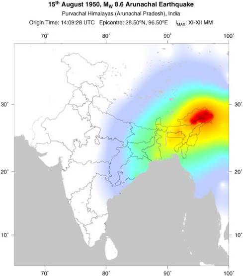
The Time magazine wrote about the 1950 earthquake[xxix]: “Shipping on the lower Brahmaputra River (whose source is in the Himalayas) was dislocated by a tide of tens of thousands of uprooted trees and the bodies of tigers, elephants and other wild life borne down the river from the earthquake area. The waters of the Brahmaputra, blackened with sulphur that the quake had churned up from the earth’s innards, cast up millions of dead and dying fish. Up in the mountains the river had been dammed by landslides. … The quake had not yet spent itself. Hills were still disappearing and new hills were rising out of the laboring earth.”
A 6.9-magnitude earthquake hit Nyingchi, southwest China’s Tibet at 6:34 a.m. on Nov 18, 2017. The landslide dams on Yarlung Tsangpo have in the past created flood disaster in downstream Arunachal Pradesh on numerous occasions including in June 2000, Nov-Dec 2017[xxx], Oct 2018[xxxi], Nov 2018[xxxii]. among others. [https://www.researchgate.net/publication/223529561_A_super-large_landslide_in_Tibet_in_2000_Background_occurrence_disaster_and_origin]
Nov 2017: The Siang river turned muddy and “blackened” in 2017 raising concerns about China’s upstream activities. The water became unfit for human consumption, with “up to ten inches of sediment accumulated on some stretches of the riverbed”. This episode severely affected agriculture production in the Siang valley, known as one of the rice bowls of Arunachal Pradesh, and it also had a detrimental impact on fishing communities. Although China stated that an earthquake in November 2017 might have been the cause, the river waters reportedly changed before the quake struck[xxxiii].
All these vulnerabilities are even more pronounced at the great bend area as the gradient here is one of the highest in the world, as also the flows and elevations. It is not for nothing that the project has been described by Chinese engineers as the riskiest one in the world.
In this opinion piece in The Hindu[xxxiv], CP Rajendran rightly says: “In this mad rush of one-upmanship, both countries ignore how unviable such ‘super’ dams projects are, given that they are being planned in an area that is geologically unstable. It is high time that India and China sat together to deliberate on the consequences of such misadventures in an area where massive earthquakes are bound to take place… Carbon neutrality should not be at the expense of the environment.”
Is China ready for the World’s riskiest, most challenging and most expensive dam project? Chinese experts have officially stated in the past that the Great Bend Hydropower project is the riskiest project and also most challenging to build considering the geology, hydrology, geomorphology, climate, elevations, meteorology and tectonics of the location. And it is also going to be the most expensive project. That was just a few years ago. It is not clear from the logistics of the area or the studies required and done that China is ready to build such a project.
It is also revealing that the Global Times report, the bible on whose basis all the discussions are going on, has clearly stated that China does not need power from this massive, 60000 MW proposal producing 300 billion KWh of power. To give an idea of how much this power is, this is almost double the power generated by India’s entire 46000 MW of hydropower capacity in 2019-20. And Chinese experts tell us that China wants to build this riskiest, more challenging and most expensive hydropower project of the world and hopes to export all of that power to India, Nepal and other neighbours! Does that even sound plausible?
Who is going to help us get our Prior Use Right? One of the reasons claimed by Indian government officials for pushing a massive hydropower project on Siang in Arunachal Pradesh is supposed to be for achieving what Indian officials fondly call “Prior Use Right”. Let us understand the reality of this proposition.
The only international convention in this regard, the UN Convention on Non navigational uses of international watercourses was approved in the UN in 1997 by a vote of 104-3. Interestingly, China was one of the only three nations that voted against the convention. India did not do itself a great favour by abstaining from voting. The convention came into force on Aug 17, 2014 after sufficient number of countries ratified it, India was not one of them, is still not one of them.[xxxv]
But even as it has come into force, as noted by a task force report from India’s defense think tank Institute for Defense Studies and Analyses, such laws are “difficult to implement and often contradictory”.[xxxvi] Unfortunately, the IDSA report ends up with a rather problematic suggestion, “As a counter-measure to China’s plan for the diversion of the Yarlung-Tsangpo, India should propose a south Asian-China-ADB power project with international support on the Great Bend.” No brainer to say that it was a non starter when it was proposed and it sounds even more preposterous today.
This commentary in The Statesman on Dec 10, 2020[xxxvii] with unwarranted title rightly suggested in the end: “India must take up with China the 1997 United Nations Convention on Non-Navigational Uses of International Watercourses that specifically focuses on shared water resources. It established two key principles to guide the conduct of nations regarding shared watercourses: “equitable and reasonable use” and “the obligation not to cause significant harm” to neighbours. There is a consensus among experts that international watercourse agreements need to be more concrete, setting out measures to enforce treaties made and incorporating detailed conflict resolution mechanisms in case disputes erupt.”
However, the author of The Statesman article did not say that India did not support the convention and in fact opposed it in the debate when the convention was being debated. In any case, where will we go to ensure the implementation of the convention? There is no credible institutional mechanism in place and China in any case has shown that it does not even respect the rights of downstream countries as we can see from the Mekong experience. Nor does China even respect the judgements of International Court of Justice.
The Intransigent, opaque China China has been opaque, intransigent, non responsive in the past. During 2004-05 incident related to Parechu landslide dam in Sutlej basin, China had refused to allow Indian scientists to visit the area. After the 73-day Doklam standoff between India and China in 2017 there were reports that China withheld hydrological data for the Brahmaputra and Sutlej rivers – in contravention of the 2008 agreement. China has already blocked the flow of the Xiabuqu river, one of Brahmaputra’s Tibetan tributaries, for the Lalho hydel project. More recently, in the aftermath of border clashes between India and China in the Galwan Valley from May 2020, China blocked the flow of the Galwan River, a tributary of the Indus which originates in Chinese-controlled Aksai Chin area, thus altering the natural course of the river to prevent it from entering India.
Why is India not demanding TEIA? There are increasing instances including those involving China where Transboundary Environment Impact Assessment[xxxviii] (TEIA) has been mentioned and justified, including cases from International Court of Justice, including one involving India (Kishanganga hydropower project). This has particular relevance and use in the context of the Great Bend Project that China is now proposing. The TEIA, being transboundary in nature, has to be done by a joint team of experts since territories of both countries are involved in the study. This will not only provide full information and likely impacts of the proposal, but also with the visit of Indian experts in the TEIA team, better information and understanding of the geographic and other features of the project location.
As is feared, if China refuses such a request, that will be both a reputational risk for China and another legal avenue for India to challenge the project. In fact, there is justification for India to demand such TEIA for every project that China takes up on shared rivers.
In addition, India can also demand a treaty with China on Brahmaputra River Water sharing, including all the tributaries of the river as a longer term measure. This could be either a bilateral one or multilateral one, also involving the other Brahmaputra basin countries Bhutan and Bangladesh.
India’s real options While entering into a race with China to build a massive hydropower project on Siang is clearly a bad idea that wont even help, what are India’s real options?
In what many consider a relevant development[xxxix], USA’s Tibetan Policy and Support Act was passed by the US House of Representatives in January (2020) and may pass the Senate soon. The Act acknowledges Tibet’s role in providing water to surrounding countries in Asia and requires the secretary of state to encourage a regional framework on water security and to pursue collaboration with China and international institutions to monitor the environment on the Tibetan plateau.
[Indian Express reported on Dec 26, 2020 that the US Senate passed it this week. It will become a law once the President signs it and replace the Tibet Policy Act of 2002. While signing it, US President Bush wrote that US foreign policy will only see it as an advisory guidance. Alleging that China is diverting water resources from Tibet, the TPSA also calls for “a regional framework on water security, or use existing frameworks… to facilitate cooperative agreements among all riparian nations that would promote… arrangements on impounding and diversion of waters that originate on the Tibetan Plateau”. While the 2002 Act said the US should establish a “branch office” in Lhasa, the TSPA ups the ante by changing that to a “consulate”. It recognises the Central Tibetan Administration. https://indianexpress.com/article/explained/reading-the-new-us-policy-on-tibet-snubs-to-china-on-dalai-lama-rivers-7120417/%5D
Interesting proposition[xl] came from Lowy Institute: “India could lead a counter-coalition of countries that share transboundary rivers [with China], and forge a common institutional set-up for better transboundary management of shared rivers. While offering greater bargaining leverage vis-à-vis China, such an institution could also promote a “Southern Asian water information grid”, and aggregate best practices for water management.” Such an alliance including Bangladesh, Bhutan, Myanmar and other South East Asian countries sharing river basins with China could impose sanctions for any upstream violations. India and other countries in South and Southeast Asia have a lot of gain by learning to bargain collectively with China.
Joel Wuthnow, a senior research fellow in the Center for the Study of Chinese Military Affairs at the U.S. National Defense University, in a commentary dated Dec 23, 2020, concluded: “In the long run, the stakeholders should lay the foundation for a more ambitious goal: the formation of a Brahmaputra Basin Commission. Such a commission — which would not have to be predicated on a resolution of territorial disputes or require a high level of preexisting trust between the riparians — can serve as a venue to air grievances among high-level officials, but also to advance cooperation where all three states’ interests are aligned, such as agreements on data sharing, search and rescue, flood control, and dam construction “best practices.” It would also allow Beijing to demonstrate its value as a leader in regional governance and stabilize overall relations with New Delhi. Aware of such benefits, Chinese academics have supported the idea of modeling cooperation on the Lancang-Mekong Cooperation Mechanism, set up in 2016 to formalize Chinese outreach with its Southeast Asian neighbors. This model might be a useful first step in the long-term goal of increasing institutionalization.” [https://warontherocks.com/2020/12/a-conflict-prone-river-takes-a-step-backwards/] Joel Wuthnow was referring to China, India and Bangladesh when he referred to three states, but should have included as Bhutan as another Brahmaputra basin state.
India can work on these suggestions. In addition, effective management of domestic rivers and rainwater has always been key a key element of any solution. Demand for Transboundary EIA is another important element, in addition to demanding a water sharing treaty. Lastly, India must use its considerable satellite monitoring prowess to monitor what China is upto along the Yarlung Tsangpo river. And it should also be taking the people of Aruachal Pradesh and Assam and and also people of India into confidence by sharing the river related information publicly.
Himanshu Thakkar (ht.sandrp@gmail.com)
POST SCRIPT:
1. Dec 23 2020 Brahma Chellaney: The article has its share of inaccuracies and only solution it offers is a sermon that China should stop building dams and then he agrees this is unlikely.
https://www.project-syndicate.org/commentary/china-dam-brahmaputra-yarlung-zangbo-water-scarcity-asia-by-brahma-chellaney-2020-12
2. Dec 25, 2020 “…while China acceded to the Environmental Modification Convention (ENMOD) – an international treaty prohibiting the military or hostile use of environmental techniques – in June 2005, it has not signed it.” By Brigadier Kuldip Singh
https://www.scmp.com/week-asia/opinion/article/3115341/why-chinas-new-hydropower-project-could-have-security
END NOTES:
[i] https://www.hindustantimes.com/world-news/china-to-build-a-super-dam-on-its-part-of-brahmaputra-river/story-i4No1OJ9JuxMEJEwCtNrTO.html
[ii] https://www.hindustantimes.com/editorials/convey-concerns-on-china-s-dam-building/story-KNQGagHwUolKVUR0pmZKON.html
[iii] https://sandrp.in/2013/07/17/brahmaputra-the-beautiful-river-or-the-battleground/
[iv] http://claudearpi.blogspot.com/2020/12/the-new-road-and-hydropower-plant-in.html
[v] SeeTao news is news media in China about influential engineering news, project news, etc.
[vi] https://www.seetao.com/details/42789/en.html
[vii] https://www.globaltimes.cn/content/1206134.shtml
[viii] https://www.globaltimes.cn/content/1208405.shtml
[ix] See for example: https://www.meltdownintibet.com/f_maps_hydrochina.htm
[x] https://www.globaltimes.cn/content/1208552.shtml
[xi] https://www.scmp.com/news/china/diplomacy/article/3111841/tibet-hydropower-plans-will-boost-international-cooperation
[xii] https://www.thehindu.com/news/international/china-hydropower-company-plans-first-downstream-dam-on-brahmaputra/article33206687.ece
[xiii] https://www.globaltimes.cn/content/1208604.shtml
[xiv] https://myrepublica.nagariknetwork.com/news/nepal-to-export-30-mw-electricity-to-india/
[xv] https://www.indiatoday.in/india-today-insight/story/why-china-s-new-brahmaputra-dam-plan-should-worry-india-1746428-2020-12-03
[xvi] https://www.hindustantimes.com/analysis/china-is-using-tibet-s-waters-against-india/story-F80hWeMRt1JMTCUSIlSduJ.html
[xvii] https://www.hindustantimes.com/analysis/china-is-using-tibet-s-waters-against-india/story-F80hWeMRt1JMTCUSIlSduJ.html
[xviii] https://thediplomat.com/2020/12/chinese-dam-plan-worries-india-but-perhaps-excessively/
[xix] http://claudearpi.blogspot.com/2020/12/the-end-of-sacredness.html
[xx] This report says the road was opened in early Nov, 2013: https://www.globaltimes.cn/content/821822.shtml
[xxi] https://www.tribuneindia.com/news/comment/chinas-super-dam-a-threat-to-indias-security-181375
[xxii] Nyingtri, traditionally known as Kongpo
[xxiii] https://energy.economictimes.indiatimes.com/news/power/india-plans-dam-on-brahmaputra-to-offset-chinese-construction-upstream/79522260
[xxiv] http://www.uniindia.com/meeting-discusses-on-hydropower-in-arunachal/east/news/2254314.html
[xxv] https://www.futuredirections.org.au/publication/indias-worries-and-chinas-tibetan-dams/
[xxvi] https://scroll.in/article/980469/india-wants-to-counter-chinas-mega-dam-plans-by-building-its-own-it-is-a-bad-idea
[xxvii] https://www.orfonline.org/expert-speak/spotlight-on-planets-largest-hydropower-project-by-china-on-yarlungbrahmaputra/
[xxviii] https://eurasiantimes.com/chinas-largest-costliest-riskiest-dam-in-tibet-will-hit-india-bangladesh-very-hard-experts/
[xxix] http://claudearpi.blogspot.com/2020/12/creating-havoc-in-tibet-and-downstream.html
[xxx] https://sandrp.in/2017/12/24/muddy-siang-is-sign-of-danger-ahead-wake-up-call-for-indian-authorities/
[xxxi] https://sandrp.in/2018/10/19/landslide-dam-on-tsangpo-creates-flood-disaster-risk-for-siang/
[xxxii] https://sandrp.in/2018/11/01/another-landslide-dam-on-yarlung-tsangpo-raises-more-questions/
[xxxiii] https://www.lowyinstitute.org/the-interpreter/india-china-relations-and-geopolitics-water
[xxxiv] https://www.thehindu.com/opinion/op-ed/hazardous-ideas-for-the-himalayas/article33322132.ece
[xxxv] https://unece.org/environment-policy/water/un-watercourses-convention
[xxxvi] https://www.rediff.com/news/column/can-india-be-firm-with-china-on-brahmaputra-dams/20101214.htm, https://sandrp.in/wp-content/uploads/2018/03/can_india_be_firm_with_china_on_brahmaputra_dams_dec_2010.pdf
[xxxvii] https://www.thestatesman.com/opinion/water-as-a-weapon-1502939911.html
[xxxviii] Nadia S. Castillo & Yongmin Bian, China’s Obligation to Conduct Transboundary Environmental Impact Assessment (TEIA) in Utilizing Its Shared Water Resources, 55 Nat. Resources J. 105 (2015). https://digitalrepository.unm.edu/nrj/vol55/iss1/5
[xxxix] https://bylinetimes.com/2020/12/18/war-over-water-the-new-flashpoint-in-the-india-china-stand-off/
[xl] https://www.lowyinstitute.org/the-interpreter/india-china-relations-and-geopolitics-water (23 July 2020)

India should welcome the proposal of building 60,000 MW run of the river project provided China hands over all the occupied Indian land as claimed by India. China can sell the surplus power from the project in electricity exchanges of India (IEX, etc.). China will be permitted to transmit power through India to Bangladesh, Nepal, etc. China can also develop hydro power plants in Karnali /Ganga river basin located in Tibet and Manasarovar Lake waters can be diverted to Karnali river basin to enhance hydro power potential and lean flows in India and Nepal. China will also be accorded most favored nation status on mutual basis with low customs duty and no import restrictions. China should not divert waters of Sutlej and Indus rivers flowing in to India. China should not consider PAK including Gilgit area as part of Pakistan but recognize as part of India. India and China agree to keep the boarder area peaceful without any military buildup and encourage boarder trade /tourism.
What else is needed for neighboring countries on the earth. If China is building the mega-project within 30 km from Indian boarder without satisfying India, It will become sitting duck for India in case of boarder clashes or war eruption.
LikeLike
We not agree with what you say. But thanks for sharing your thoughts.
LikeLike