
While one can never be too sure what is the exact meaning of Chinese whispers, a thoughtful response has to take into account the available facts and the context. This report tries to take stock of available facts and context of this latest episode that started at the end of November 2020 and is still going on: China’s proposed massive hydropower project on the Great Bend of Yarlung Tsangpo River just before the river enters India as Siang, a tributary of Brahmaputra river. It also reviews the key media reports published on this issue.
Continue reading “Why is India not demanding TEIA for the Great Bend Hydro proposal of China?”Tag: Siang River
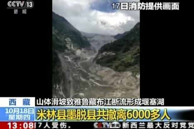
Landslide DAM on Tsangpo creates flood disaster risk for Siang
A massive dam, created by landslide in early hours (around 5 am) of Oct 17,2018 has blocked the main stream of Yarlung Tsangpo in Tibet. The reservoir behind the dam already has humungous 360 Million Cubic Meters (MCM) of water by 7 am on Oct 18, 2018 and as per latest reports (subsequently saw the CWC tweet put out at 955 pm on Oct 18, saying that storage had reached 484 MCM by 8 pm on Oct 18), the reservoir is still growing in size. The exact location of the landslide dam is uncertain. According to one source, the latitude longitude could be 94.93754° E, 29.74957° N, but this may not be accurate the likely location may be a few kilometers downstream from here. The Chinese media[i] has reported that the landslide dam is located at near Gyalha village in Milin or Manling county. According to some experts who visited the site, the dam could breach very soon, possibly on Oct 19, bringing massive floods along Siang river in Arunachal Pradesh. Continue reading “Landslide DAM on Tsangpo creates flood disaster risk for Siang”
")
DRP: 8 Jan 2018 (“THIS IS RIVER, NOT LAND” Chennai Fisherfolks Fight To Save Ennore river)
In a remarkable protest echoing urgent need for protection of rivers, fisherfolk of Kosasthalai River on 03 January 2018, launched a ‘Jal Satyagraha’ against Kamarajar Port project. The proposal would divert 1000 acres of creek area. It mainly comprises of river, wetlands, marshy areas on which fisher community depend for livelihood.
Raising their voices against the project with holding play cards that read “This is River, Not Land” they stood in waist-deep in waters to save Ennore Creek. Joining the protest, hundreds of residents also demanded the withdrawal of alleged fraudulent maps denying the existence of the Ennore Creek. The community has been fighting a lonely battle against the Tamil Nadu government accusing it of turning wetlands illegally into industrial real estate corridors.
– “Fishing economy has been hit massively. Shrinking of water body means less space for fish. Shrinking has happened in terms of surface spread as well as depth thanks to the dumping of dredged sand from the sea, silting the waterbody. The larger concern is fly ash and heavy metals from the industries polluting the environment causing health hazards,” said Nityanand Jayaraman, Environmental activist and researcher who was part of the protest. https://www.oneindia.com/india/chennai-fisherfolk-stage-jal-satyagraha-to-save-ennore-creek-2613088.html (One India, 04 January 2018)
Continue reading “DRP: 8 Jan 2018 (“THIS IS RIVER, NOT LAND” Chennai Fisherfolks Fight To Save Ennore river)”
DRP: 25 Dec 2017 (CAG Report Shows Ganga River Has No Hope Under NMCG)
Apart from mentioning Govt failure in checking Ganga pollution, the Comptroller & Auditor General’s (CAG) performance audit report on Ganga rejuvenation tabled in Parliament on December 19, 2017 specifically mentions that National Mission for Clean Ganga (NMCG) “could not finalize the long-term action plans even after more than six-and-a-half years of signing of agreement with the consortium of Indian Institutes of Technology”. The fact that NMCG does not have a “river basin management plan even after a lapse of more than 8 years of National Ganga River Basin Authority notification”, mentioned in the report also has great significance.
It is surprising that NMCG is working without a river basin management plan or a long-term action plan. The CAG performance audit is also lacking. It rightly mentions that infrastructure to treat pollution has not been created but does no assessment whether the creation of infrastructure alone would revive the river.
Further, CAG audit does not look into the issues if lessons from past failures have been learnt, corrections done, independent scrutiny institutionalised, participatory governance achieved, and if this business as usual approach is going to achieve any better results even if all the money were spent, all the DPRs were sanctioned, all the meetings happened, all the manpower available and all the STPs constructed?
Hence it critical that CAG performance audit should have tried to address these issues. Can the state of Ganga improve without improving the state of tributaries? CAG does not even look at this issue.
The CAG report shows that this programme provides no real hope for better future of Ganga and Modi and his government will have a lot to answer when they go to polls in less than 1.5 years. It’s a serious indictment for the govt in general and Modi in particular since he has said right from the beginning that Ganga is their priority and all that they have tried is audited here. http://www.livemint.com/Politics/KW6MIOrOvMvZvEGeozwifJ/CAG-slams-Centre-for-failing-to-utilize-funds-for-Ganga-reju.html; http://indianexpress.com/article/india/ganga-pollution-hc-orders-uttarakhand-govt-to-seal-establishments-polluting-rivers-4991923/; https://timesofindia.indiatimes.com/city/dehradun/building-of-ghats-crematoria-on-ganga-misses-nov-deadline/articleshow/62234114.cms https://www.nationalheraldindia.com/environment/pm-modi-fails-to-clean-up-his-mother-ganga
Continue reading “DRP: 25 Dec 2017 (CAG Report Shows Ganga River Has No Hope Under NMCG)”")
DRP: 4 Dec 2017 (Protests Against Pancheshwar Dam in Champawat, Pithoragarh, Almora, Delhi)
Protests and controversies around Pancheshwar Multipurpose Project (PMP) are only growing louder and wider. While Expert Appraisal Committee (EAC) Rivers Valley Project in unnecessary hurry considering the project tomorrow (05 Dec. 2017) http://environmentclearance.nic.in/writereaddata/Form-1A/Agenda/2811201745T4GD5I10thAgendaEACHydro05122017.pdf
Villagers and local groups people also continue raising their concerns and objections against 5040 Mw dam project. Today, scores of villagers, environmental groups including regional political party have protested at Jhulaghat in Champawat, Pithoragarh, Almora and in Delhi demanding EAC to listen to the voices of local people and groups.
Continue reading “DRP: 4 Dec 2017 (Protests Against Pancheshwar Dam in Champawat, Pithoragarh, Almora, Delhi)”Arunachal Pradesh Groups Ask MoEF to Cancel Illegal Public Hearing of Lower Siang
22nd January 22, 2014
Dr. V. Rajgopalan
Secretary,
Ministry of Environment and Forests,
New Delhi.
Sub: 2700 MW Lower Siang project – Cancel Illegal Public Hearings proposed for January 31st 2014.
Dear Dr. Rajgopalan,
We write to you on behalf of the Forum for Siang Dialogue (FSD), Siang Peoples’ Forum (SPF) Sirit-Siyom Banggo Dam Affected peoples’ Forum (SSBDAPF), Siang Bachao Andolan (SBF), Nyiko Bachao Forum (NBF) to seek cancellation of the Three public hearings proposed to be held for the 2700 MW Lower Siang hydroelectric project in the East Siang, West Siang and Upper Siang districts of Arunachal Pradesh on January 31, 2014.
Through a notification dated 30th December 2013 published in the Arunachal Times dated 31st December 2013 the Arunachal Pradesh State Pollution Control Board (APSPCB) has announced the conduct of public hearings for the 2700 MW Lower Siang project in three districts of Arunachal Pradesh. A scanned copy of the notice is attached for reference (Annexure 1).
There are a number of legal reasons due to which the public hearings need to be cancelled, here are a few of them:
1) Public hearing on the same day and time in the West Siang, East Siang and Upper Siang districts of Arunachal Pradesh
There are a number of local persons/clans/local communities who have land directly affected by the Lower Siang project cross-cutting the district boundaries. Such persons/clans/local communities will not be able to exercise their legal right to participate in all the public hearings in the districts where their ancestral lands are affected, since they are being held on the same day, at the same time. This is a gross violation of the letter and spirit of the EIA notification 2006 as well as the article 14 of Right to equality and article 19, the freedom of Speech under the Constitution of India.
It is crucial that the public hearings are held in the three districts with sufficient days in between to enable the affected persons to participate in the public hearings wherever their ancestral lands are affected.
It cannot be argued that they should put their viewpoints in one of the public hearings in one of the districts. It is their legal right to participate in the public hearings wherever their lands are affected. This is a clear ground for cancellation of the public hearings and re-announcement by keeping sufficient days in between hearings being held in different districts.
2) Location of public hearing venue more than 100 km. away from 11 villages
The public hearing venue fixed for the East Siang district is Pasighat, the district headquarters, in the downstream-affected area of the project. While the APSPCB is welcome to organise a separate public hearing for the downstream-affected area, this is an extremely inconvenient location for the upstream-affected villagers in the East Siang district who are directly affected. And Pasighat town is nowhere listed as an affected village/area/circle in the EIA,EMP and Social Impact Assessment report of the Project Proponent. (Attached is the list of the affected villages as prepared by WAPCOS for the project.
The Public Hearing for Upper Siang District is also fixed at Katan which is 40 Kms away from Geku villages, which is encompassing the majority of the villages to be affected by the dam and above all there are not even a single Govt/Public or Private transport plying/ operating there. And the only village which is going to be completely submerged happens to be Pongging village under Upper Siang district, and the people have to walk on foot covering a distance of 17 kilometers to reach Katan as there is no Public/Private/Govt Transport system plying there.
Out of the 25 villages directly affected in East Siang district, at least 11 are more than 100 kms. away from the public hearing venue! In fact Riga village, one of the severely affected village under East Siang District is 172 km. away from Pasighat. A further nine villages are 60 – 100 km. away. Please note that 6 (Six) villages have to walk for up to 12 km. even before reaching the motor able road.
It is clear that the public hearing venue in East Siang district has been decided in order to disallow active participation of directly affected villages. This is completely unacceptable as per the letter and spirit of the EIA notification 2006 and various court orders/judgements on the need for proximity of the public hearing venue to the affected area. Public hearings cannot be located as per convenience of government officials who do not want to travel to affected areas and stay in the district headquarters. This another strong ground why the public hearings announced for 31st January 2014 have to be cancelled immediately.
And Chapter II U/s 5 of The Right to Fair Compensation and Transparent Land Acquisition Relief and Resettlement Act 2013 also clearly states that Public Hearing should be held in the Affected area and not otherwise.
3) Siang river basin cumulative impact assessment study is not complete and placed in the public domain at designated places before public hearing
Section 9.4 of Form I of the EIA notification requires that cumulative impacts of a project are examined during the EC process. Further the Ministry of Environment and Forests (MoEF) has issued an OM dated 28th May 2013 stating that it will consider hydropower projects based on cumulative impact assessment and carrying capacity studies. The OM is attached as Annexure 2.
The OM states that:
“While the first project in a basin could come up without insisting on cumulative study for all subsequent hydro-power projects in the basin it should be incumbent on the developer’ of the second/other project(s) to incorporate all possible and potential impact of other project(s) in the basin to get a cumulative impact assessment done.”
An important aspect of Appraisal done by EAC/MoEF is detailed scrutiny done of all documents including public consultation proceedings. As per the EIA notification 2006 (section 9.4 of Form I) and the MoEF’s OM dated 28th May 2013 if cumulative impacts studies have to be the basis for decision-making, then such studies have to placed in the public domain at designated places 30 days prior to the public hearing.
However, the Siang river basin cumulative impact assessment is neither complete nor placed in the public domain at the designated places prior to the public hearing. Please note that this study currently underway is looking at all projects in the Siang river basin (Siang and its tributaries).
Although we disagree with the logic that the first project could come up without ‘insisting’ on a cumulative impact assessment study (since that project could be the most ecologically and socially destructive), in this case Lower Siang is NOT even the first project in the river basin for which either a public hearing is being held or being considered for environmental clearance. A number of public hearings have been held for other projects in Siang river basin and projects have also been already considered for Appraisal by EAC/MoEF. In fact 1000 MW Siyom and 700 MW Tato II project in the Siang river basin have already received final environmental clearance from the MoEF.
By no stretch of imagination is the 2700 MW Lower Siang project the first project being considered in the Siang river basin. Therefore as per the MoEF’s own OM dated 28th May 2013, Siang river basin cumulative impact assessment will first have to be completed. Public hearing should only be held after this is completed and these reports are placed in the public domain at least 30 days before the hearing.
Keeping all this in mind we strongly urge the MoEF to direct the APSPCB to cancel the Illegally notified public hearings proposed for the 2700 MW Lower Siang project on 31st January 2014.
Thanking you,
Sincerely,
Vijay Taram Oyar Gao Tayek Mize Tasong Mibang Takar Komut Kento Jini Reken Ingo
Forum for Siang Dialogue, Siang Peoples’ Forum, Sirit Siyom Banggo Dam Affected Peoples’ Forum, Siang Bachao Andolan, Nyiko Bachao Forum
Cc:
1) EAC on River Valley & Hydroelectric projects
2) Chairperson, Arunachal Pradesh State Pollution Control Board
3) Member Secretary, Arunachal Pradesh State Pollution Control Board
Letter to APSPCB – Non-availability of Complete EIA-EMP Report of Lower Siang HEP is a Violation of statutory Norms
21st January 2014
To
Chairman and Member Secretary,
Arunachal Pradesh State Pollution Control Board
Paryavaran Bhawan, Yupia Road
Pappu Hills, Naharlagun
E-mail id – arunachalspcb@gmail.com
Sub: Lower Siang HEP (2700 MW) EIA-EMP Report not fully available on APSPCB website; many links not working; Public hearing will be illegal without full EIA-EMP in public domain
Respected Sir,
This is regarding the EIA-EMP report of Lower Siang HEP (2700 MW) uploaded on APSPCB website. The public hearing for the Lower Siang HEP is schedule to be held on 31st January 2014.
As per the EIA notification of 2006 the full and complete EIA and EMP report should be made available on State Pollution Control Board website, in this case your website at least 30 days in advance of public hearing date as this is necessary not only for the affected people but also for wider consultations for concerned individuals and groups, as required under the EIA Notification. However, full EIA-EMP are not available on your website, with at least three chapters of EIA, one chapter of EMP and several annexures not opening, even ten days before the public hearing date.
It is very surprising and confusing to most people to see that the reports have been uploaded in 145 parts totaling 320 MB file size. These documents should have been uploaded as five reports as done for EIA-EMP report of several other projects. However, we have gone through all the files available on APSPCB website and based on perusal of these files, we find that crucial parts of the statutorily required documents are not available on APSPCB website. The list of missing chapters and annexures with the name of the report is given below. A screenshot of the links to these chapters are also attached and annexure as mentioned below.
| No | Chapter/Figure | Report | Status | Attached |
| 1 | Chapter 2 – CONCEPT & METHODOLOGY | EIA | Failed to upload | Annexure 1 |
| 2 | Chapter 10 – AQUATIC ECOLOGY FISH & FISHERIES | EIA | An incomplete, possibly irrelevant table on a 1-page | Annexure 2 |
| 3 | Chapter 12 – CONSTRUCTION METHODOLOGY | EIA | Failed to upload | Annexure 3 |
| 4 | Chapter 10 – REHABILITATION & RESETTLEMENT PLAN | EMP | Failed to upload | Annexure 4 |
| 5 | Fig 3.3 – Gradient profile of Siang river including its major and minor tributaries of the Siang river catchment | EIA | Not uploaded | |
| 6 | Fig 3.4 – Gradient profile of the Siang river with its main tributaries in the Siang river catchment area | EIA | Not uploaded | |
| 7 | Fig 7.3 – Land use/ land cover map of the submergence area of the proposed Lower Siang H.E. project | EIA | Failed to upload | Annexure 5 |
| 8 | Fig. 2.3 – Drainage map of the free-draining catchment area of the proposed Lower Siang H.E. project | EMP | Not uploaded | |
| 9 | Fig 7.3 & 7.4 – Cross-section at the proposed dumping site | EMP | Incomplete, failed to upload | Annexure 6 |
We therefore request you to upload these chapters immediately and also upload smaller size single documents of each report for the perusal of the local people and all concerned. In the meanwhile, since non availability of full EIA-EMP on pollution control website a month before the public hearing is a statutory violation, we request you to cancel the public hearing now slated for Jan 31st, 2014 as holding a public hearing without full EIA-EMP on the APSPCB website a month before the PH will not be legally tenable.
Thanking you, we will look for your early response,
Yours Sincerely
Parag Jyoti Saikia
South Asia Network on Dams, Rivers & People (SANDRP), 86-D, AD Block, Shalimar Bagh, Delhi – 110 088
Tel: 91-11- 2748 4654/55; https://sandrp.wordpress.com/, https://sandrp.in/

Brahmaputra – The Beautiful River or The Battleground?
The Brahmaputra River, geologically is the youngest among the major rivers in the world yet it is known as a moving ocean. The river Brahmaputra travels 2880 km from its origin in the young Himalayan range through the Tibet and India and finally merges with the sea in Bangladesh by opening its streams like the roots of a large Banyan tree. While traversing through India the river is astonishingly wide at some areas. In Upper Assam near Dibrugarh the river is 16 km wide where as in lower Assam at Pandu, near Guwahati the river is 1.2 km wide but in the immediate downstream it is nearly 18 km wide. Brahmaputra which is mainly a glacier fed river has also the distinction of being the river with highest sediment yield 852.4 t/km2/y in the world and second highest water yield at delta, next only to Amazon.[1]
Origin and Path
The BrahmaputraRiver originates in the Chemayungdung mountain ranges which nearly sixty miles south-east of Mansarovar lake in the MountKailash range in Southern Tibet at an elevation of 5300 m.A spring called Tamchok Khambab spills from the glaciers which later gather breath and volume to become the Tsangpo, the highest river in world.

Source: http://kids.britannica.com/comptons/art-67000/A-Buddhist-shrine-called-a-stupa-overlooks-the-Brahmaputra-River
Out of its total length of 2,880 km the Brahmaputra covers a major part of its journey in Tibet as Tsangpo. Tsangpo or the BrahmaputraRiver flows 1625 km in Tibet parallel to the main range of Himalayas before entering India through Arunachal Pradesh.
Apart from the name Tsangpo, the Brahmaputra is also known by its Chinese name, Yarlung Zangbo in Tibet. There are several tributaries of Tsangpo in Tibet. According to Encyclopedia Britannica, Raka Zangbo (Raka Tsangpo), Lhasa (Kyi) and Nyang Qu (Gyamda) are prominent north bank tributaries where as Nyang Qu (Nyang Chu) is a tributary on the south bank. The Raka Zangbo (Raka Tsangpo) joins Tsangpo in the west of Xigazê (Shigatse) and Nyang Qu (Gyamda) River joins the river from the north at Zela (Tsela Dzong). The Lhasa (Kyi) river flows past the Tibetan capital of Lhasa and joins the Tsangpo at Qüxü. The right bank tributary Nyang Qu (Nyang Chu) meets the Tsangpo at Xigazê.
Before entering India, the river passes Pi (Pe) in Tibet and suddenly turns to the north and northeast and cuts a course through a succession of great narrow gorges between the mountain Gyala Peri and Namjabarwa (Namcha Barwa) in a series of rapids and cascades.

Source: http://greenbuzzz.net/nature/the-biggest-canyons-in-the-world/
The river then turns south and southwest and flows through a deep gorge across the eastern extremity of the Himalayas with canyon walls that extends upward for 16,500 feet (5,000 meters) and more on each side. This is the celebrated great bend where China has plans to build the world’s biggest hydropower project of 40 000 MW capacity and also divert water from here to the North China, though China is currently denying any such plans.

Source: https://www.facebook.com/lovely.arunachal/media
The river enters Arunachal Pradesh near Gelling where it is known as the Siang or Dihang. The total length of Siang River is 294.5 km till its point of confluence with Dibang and Lohit River. The elevation of Siang river catchment area ranges from 90 m to around 5800 m. In India the total catchment of Siang river up to its confluence with Dibang is 14965.30 sq km.[2]
The SiangRiver meets two other major tributaries of Brahmaputra, Dibang and Lohit in the west of Sadiya, at a place named Kobo. From this confluence point, the river is known as the Brahmaputra till it enters Bangladesh. In India the journey of the river Brahmaputra is 918 km long.
A recent study has shown that Kobo used to be confluence point in 1915. By 1975 the confluence shifted to a place called Laikaghat which is 16 km downstream of the earlier point of confluence. In 2005 through satellite images it was observed that the confluence point has shifted “19 km farther downstream”.[3]
The river crosses Assam below Dhubri and enters Bangladesh where the river is known as Jamuna and it flows for 337 km. Regarding Brahmaputra’s role in Bangladesh a study writes “The Jamuna is the local name given to the river for its entire length in Bangladesh to the Ganges junction.

Source: http://www.trekearth.com/gallery/Asia/India/North/Uttar_Pradesh/Agra/photo322311.htm
The Brahmaputra-Jamuna has one principal tributary input, the TeestaRiver in the north-west, and two major offtakes on the left bank that are the Old Brahmaputra and the Dhaleswari. The Brahmaputra/Jamuna River contributes ~51% of the water discharge and 38% of the sediment yield to the Padma (Schumm and Winkley, 1994), with the sediment yield being estimated at 590 MT/ yr and the sand fraction contributing 34% of this total (Sarker, 1996).”[4] The Jamuna joins the Ganges at Goalundo Ghat and from here the combined flows of these two mighty rivers are known as Padma which joins Meghna in the downstream. The united stream thereafter known as the Meghna and with this name the river Brahmaputra ends its journey, entering the Bay of Bengal.
Bhutan forms an integral part of the Brahmaputra river basin even though it does not come in the path of the river. In our subsequent blogs we will bring a detail account of Bhutan’s role in Brahmaputra river basin.
The Brahmaputra River Basin
The Brahmaputra river is an international river and its river basin is spread over four countries Bhutan, Tibet , India and Bangladesh with a total basin area of 5,80,000 sq. km. Out of this total catchment area 50.5% lies in Tibet, 33.6% in India, 8.1% in Bangladesh and 7.8% in Bhutan. For geologist and environmentalist the Brahmaputra is a very unique river because “drains such diverse environments as the cold dry plateau of Tibet, the rain-drenched Himalayan slopes, the landlocked alluvial plains of Assam and the vast deltaic lowlands of Bangladesh.”[5]

In India the total basin area of BrahmaputraRiver is 197 316 sq. km. which 5.9% of the total geographic area of the country. In India the river is spread over states of Arunachal Pradesh, Assam, West Bengal, Meghalaya, Nagaland and Sikkim.
In India state-wise the drainage area of the BrahmaputraRiver is as follows:
|
State |
Drainage area (sq. km) |
% of state area in Brahmaputra basin |
| Arunachal Pradesh | 83 740 | 100% |
| Assam | 71 216 | 90.79% |
| West Bengal | 12 585 | 14.18% |
| Meghalaya | 11 780 | 52.52% |
| Nagaland | 10 895 | 65.71% |
| Sikkim | 7 100 | 100% |
| Total | 197 316 | — |
Source: ‘Intregrated Water Resource Development: A Plan for Action’, MoWR, Govt. of India, September, 1999
The Arunachal Pradesh and Nagaland portion of the Brahmaputra river basin is mainly covered by mountain ranges and narrow valleys. Meghalaya part of the basin is majorly covered by hills where as Assam and West Bengal are mostly plain areas.
Politically in India the basin is spread over 22 parliamentary constituencies (2009) comprising 12 in Assam, 4 in West Bengal, 2 in Arunachal Pradesh, 2 in Meghalaya, 1 in Sikkim and 1 in Nagaland.
Projected Water Use for Diverse Purposes in the Brahmaputra Basin
| Catchment Area | 197 316 km2 |
| Population (1991 census) | 29.1 million |
| Surface-Water Potential (Av Annual) | 629 km3/year |
| Utilisable Surface Water | 24 km3/year |
| Total Replenishable Ground Water (Av. Annual) | 26.55 km3/year |
| Natural Groundwater Recharge from Rainfall | 25.72 km3/year |
| Estimated Utilisable Flow excluding Ground Water | 21 km3/year |
Source: ‘Integrated Water Resource Development: A Plan for Action’, MoWR, Govt. of India, September, 1999
Tributaries of Brahmaputra

Source: Environment Assessment Report Siang Basin In Arunachal Pradesh, Interim Report June 2012
Studies have stated that the Brahmaputra river in its entire course receive water from a large number of tributaries. A study called “Study of Brahmaputra River Erosion and Its Control” done by IIT Roorkee[6] stated “the Brahmaputra receives as many as 22 major tributaries in Tibet, 33 in India and three in Bangladesh.” However this study did not mention anything about the river in Arunachal. We have already mentioned about the few of the tributaries Tibet. In Arunachal the major tributaries of Siang River are Ringong Asi, Yang Sang Chhu, Sigong/ Sirapateng, Niyikgong, Angong, Simang, Yamne, Siyom, Yargyap, Hirit Korong.[7]
In the course of journey through Assam from east to west, some of the important tributaries of the BrahmaputraRiver which join the river on the north bank are Lohit, Dibang, Subansiri, Jiabharali, Barnadi, Puthimari, Pagladia, Beki, Manas, Ai, Gabhoru, Chompawati, Sankosh, Raidhak, Torsa, Teesta etc. Burhidihing, Desang, Dikhow, Jamji, Bhogdoi, Kakdonga, Dhansiri, Kopili, Kolong, Sonai, Digaru, Bharalu, Krishnai, Dudhnoi are the major tributaries on the left bank. The actual number of rivers and rivulets which joins the mighty river is much larger than this list. In subsequent blogs we will try to go into details of some of the tributaries of the river Brahmaputra.
Hydrology of Brahmaputra
For the river Brahmaputra the average annual flow (water discharge) throughout Assam vary from 8500 to 17000 cubic meters per second. At Pandu Ghat near SaraighatBridge the average annual floods recorded was 16,000 cubic meters per second. During floods water discharge reaches its peak and the yearly average peak flow recorded was approximately 51,000 cubic meters per second.[8] At its mouth in Bangladesh, the average annual discharge of the river is 19,830 cubic meters per second. This is the fourth highest average annual discharge in the world. For the river Brahmaputra the highest daily discharge was recorded in August 1962 at Pandu which was 72,726 cubic meters per second. The lowest daily discharge at the same place was 1757 cubic meters per second in February 1968.[9]

Source: ‘Riverbank erosion: a perspective” presentation by Dr. Bipul Talukdar, Assam Engineering College
Though the Brahmaputra has been described as a braided river, recent studies have shown that the river does not fit into the conventional definition of braided river. A recent study states “In the study reach of the upper Assam area, the Brahmaputra appears to be a multichannel and multi-pattern river that has a tendency to very frequently generate ananabranching[10] (Latrubesse, 2008) pattern in decadal scale.” [11]
The Brahmaputra has been widening its (riverbed) size continuously from the last century. Reports from Water Resource Department showed that in Assam the river Brahmaputra was spread over for 4000 sq km in 1920 but in 2008 this has increased to 6000 sq km.[12]
The Brahmaputra along with several of its major tributaries like Subansiri, Jia Bharali, Manas had very high water yields[13] which are higher than most of the major rivers in the world. The reason behind such high water yield for Dr. D.C. Goswami, one of the renowned environmental scientist from Assam is “High monsoon rainfall in the upper catchments and their steep gradients are considered to be the major factors responsible for the high rates of unit discharge which in turn help generate the high sediment yield from the basin and contribute significantly towards causing drainage congestion in the valley.”[14]
Seismicity and Brahmaputra Basin
The Brahmaputra river basin and its adjoining hill ranges are seismically very unstable because it is located in the Eurasian (Chinese) and Indian tectonic plates. The most severe earthquakes with Richter magnitude 8.7 was recorded twice in the valley, in 1897 and 1950. The latter one particularly had severe impacts on the river Brahmaputra. As a result of this earthquake river bed was raised at least by three meters at Dibrugarh which had increased the flood and erosion intensity of the river. In the opinion of geomorphologists “the region’s active seismicity has a significant impact on the hydro-geomorphic regime of the Brahmaputra system of rivers, causing landslides that result in the natural damming of rivers, flash floods due to the bursting of landslide-induced temporary dams, raising of riverbeds by siltation, fissuring and sand venting, elevation of existing river and lake bottoms and margins, creation of new water bodies and waterfalls due to faulting.”[15]
Climate Regime
The Brahmaputra in its path from snow covered mountains of Himalaya to the deltaic flood plains of Bangladesh covers different climatic regimes. The mean annual rainfall in the Brahmaputra basin excluding the Tibetan portion is 2300 mm. The distribution of rainfall is different at different parts of the basin. In the southern slopes of Himalaya the rainfall is over 6000 mm but in parts of Nagaland this is 1200 mm. The monsoon rainfall (June to September) contribute 60-70% to the annual rainfall of the basin.[16]
In this basin, areas which are above or equal to the elevation of 1500 m experience snowfall. In the Indian part of Brahmaputra basin there are 610 glaciers which covers an area of 928.91 sq km and the volume of these glaciers are 49.57 cubic km. Out of these 449 glaciers are in Teesta basin and 161 glaciers are in Arunachal.[17] In the Brahmaputra basin, Himalayan snow and glacial melt waters play a very significant role in water availability and climate change will have severe impacts on this. Climate change will also impact the rainfall and snowfall pattern in the Brahmaputra basin. This issue needs more serious attention and we will come up with more detailed blogs on this.
Bio-Diversity in the Brahmaputra Basin

Photo: Neeraj Vagholikar
The Brahmaputra river basin hosts very rich and unique bio-diversity. The whole of northeastern region is a globally recognized bio-diversity hot spot. In the Indian territory the total forest cover of the Brahmaputra basin is 1,14,894 sq. km. which is 54% of the total basin area. In the distribution of forest cover among 6 states in Brahmaputra basin, Arunachal Pradesh tops the list with 82.8% forest cover but it is sad that the highest number of hydro-electric dams are planned in this state inviting disastrous impacts for the biodiversity, forests, people and environment. The tally of rest of the five states is as follows – Nagaland (68.9%), Meghalaya (63.5%), Sikkim (38.1%), West Bengal (21.4 %) and Assam (20.6 %).
Besides, the aquatic bio-diversity of the Brahmaputra and its tributaries is also very rich. Here we should also take the case of ‘beel’ or wetlands in the Brahmaputra flood plains which according to experts work as ”ecotonal zones” and ”play an important role in the dynamics of the Brahmaputra ecosystem, as these are natural feeding and breeding grounds for a number of fish species and other aquatic fauna.”[18]
Flood and Erosion
Brahmaputra river basin is known to be very prone to flood and erosion and these two hazards have led to many problems in the basin. In India, out of the eight northeastern states, Assam faces the most severe brunt of flood and erosion. Both flood erosion has been severely affecting the economy as well political, social and cultural milieu of Assam.
Experts opine that natural as well anthropogenic factors lead to devastating floods in northeastern region. “The unique geo-environmental setting of the region vis-à-vis the eastern Himalayas, the highly potent monsoon regime, weak geological formation, active seismicity, accelerated erosion, rapid channel aggradations, massive deforestation, intense land use pressure and high population growth especially in the floodplain belt, and ad hoc type temporary flood control measures are some of the dominant factors that cause and/or intensify floods in the Brahmaputra and the Barak basins (Goswami, 1998).”[19] The Brahmaputra river basin is also prone to flash floods and some of the worst flash floods have occurred in the valley in the new millennium.
Along with floods, erosion is also threatening the lives of the people in the state of Assam as it leads to permanent loss of land. Here we can take the case of the river island Majuli, which had been one of the worst sufferers of the erosion done by Brahmaputra. In 1853 the total area of Majuli was 1129 sq km but it has now reduced to 3.55 sq km.[20]

Source: http://www.npr.org/blogs/pictureshow/2011/11/14/142219164/capturing-the-unseen-side-of-bangladesh
In Bangladesh the Brahmaputra river which known as Jamuna is also infamous for severe floods and erosion. The river carries huge water and sediment discharge in this deltaic region. Because of its geographical setting, Bangladesh is very much dependent on its river for fertile fields and diverse flora and aqua culture but rivers also brings several hazards in the form of floods and erosion. Bangladesh has witnessed severe annual floods but the floods in 1987, 1988, 1998 and 2004 were the most severe ones in recent decades. But studies have shown that, “The people of Bangladesh have adapted their lifestyle for centuries to live with river flooding – frequently moving their temporary bank-side homes, planting on newly emergent river bars, and sometimes raising their homesteads above water level in flood periods (Paul, 1997). However, a growing population, coupled with the expansion of infrastructure and economic development, has resulted in an increase in the intensity of flood damage (FPCO, 1995; Paul, 1997; CPD, 2004). The lives of many millions of Bangladeshi citizens is thus reliant on these rivers, with up to 600,000 people living on the riverine islands and bars alone (Sarker et al., 2003).”[21]
In order to protect people from the fury of floods and erosion the main measure taken in India as well in Bangladesh is the construction of embankments. In Assam the total length of embankment is 4,473.83 km constructed on a total of 130 small and big rivers. But recent reports say that out this, 3376 km embankments are in a vulnerable condition and need immediate strengthening and repair.[22] As a deltaic region Bangladesh too has put its thrust on increasing length of embankments. In 1989 Bangladesh launched an elaborate flood control programme through construction of embankments which was named as ‘Flood Action Plan’. But this plan was vehemently criticized both at national and international level.
Source: http://peakwater.org/wp-content/uploads/2011/07/Lower-Subansiri-turbines-protest.preview.jpg
In order to control the floods in Brahmaputra valley one of the proposed solution is construction of multi-purpose dams. In fact flood control was one of the pretexts for hydro-development in the northeastern region. But the idea that multipurpose dams can lead to flood control along with hydro-power generation is actually contradictory and unviable as seen from experience of such projects. Studies done on some of the biggest multi-purpose river valley projects of independent India, e.g. ‘Unravelling Bhakra’ by Shripad Dharmadhikary, ‘Drown and Dammed’ done on Hirakud by Prof Rohan D’Souza, “One Valley and a Thousand: Dams, Nationalism, and Development, Studies in Social Ecology & Environmental History” on Damodar Valley dams by Daniel Klingensmith have shown how unviable this proposition is. A number of these dams have actually created avoidable flood disasters in the downstream areas due to wrong operation of the dams[23]. In case of the mightly Brahmaputra river, this is likely to prove even greater disastrous considering its characteristics described above.
Today Brahmaputra valley is witnessing severe opposition against hydro-power dams. The struggle against the Lower Subansiri hydro-electric project can be regarded as milestone. In the Brahmaputra valley the hydropower projects have been opposed also because of the impacts which it will going to have in the downstream as well as on the biodiversity, seismicity, society and culture of one of the most ecological sensitive areas. .
Institutional Mechanism over Brahmaputra in India
The Brahmaputra Board is the foremost body on Brahmaputra established by Government of India under an Act of Parliament i.e. The Brahmaputra Board Act, 1980 (46 of 1980) under the Ministry of Irrigation which now renamed as Ministry of Water Resources. The main task entrusted on Brahmaputra Board is ‘planning and integrated implementation of measures for the control of floods and bank erosion in the BrahmaputraValley and for matters connected therewith.’ Both Brahmaputra and Barak valleys are under the jurisdiction of Brahmaputra Board. Even though this independent board was established to better manage the flood and erosion problem of the two river basins, but its activities have come under severe public criticism. Besides Brahmaputra Board, the State Water Resource Department and Central Water Commission also looks after water issues in the river basin. Recently international funding agency Asian Development Bank (ADB) has come to be associated with flood and erosion control in the Assam but from the experiences of Bangladesh, the advent such agencies must be dealt with precaution.
Brahmaputra Valley as the Point of Confluence for People and Cultures
The Brahmaputra is a dynamic river whose dynamism is not only limited to its physical characters or features of the river, but immersed in social, political, economic and cultural aspects. The Brahmaputra valley has been the space of assimilation for people from different races and the one can find large variety of languages and dialects being spoken in this valley. The northeastern region falls under the Brahmaputra and Barak River basin[24] which is home for more than 166 separate tribes, 160 scheduled tribes and over 400 other tribal and sub-tribal communities and groups, speaking a wide range of languages (Climate Change in India: A 4×4 Assessment, 2010). The northeastern region can also be considered as an ‘ethnological transition zone’ between India and the neighbouring countries of Bhutan, Tibet, Burma and Bangladesh. In this region one can find 220 languages belonging to three language families – Indo-Aryan, Sino-Tibetan and Austric.[25]
Relevance of Brahmaputra for Assam
For Assam, the state located at the center of the northeastern region, the river Brahmaputra paves its way through this state like the lifeline of the state. The river ‘Brahmaputra’ literally means ‘Son of Brahma’. It is also one of the few rivers in India which is regarded as a ‘male’ river. There are several myths and legends about the Brahmaputra’s origin and we will bring those together in our coming blogs.

In Assam Brahmaputra River is also known by several other names i.e. ‘Luit’, ‘Siri Luit’, ‘Bor Luit’ ‘Bor Noi’. For the people of Assam, the Brahmaputra is a symbol of great pride due to its ‘moving ocean’ size but this also ignites fear when it rises to its strength during floods. People of Assam have faced difficult times when the river has come to its full strength. Famous singer Jayanta Hazarika wrote, when he formed ‘Xur bahini’ to gather relief for flood victims “Luitor Bolia baan, toloi koloi nu dhapoli meliso, hir hir sowode kal roop dhori loi kaak nu bare bare khediso (Oh the maddening floods of Luit, where are you heading this time. Whom are you chasing again with frightening sound of your waves)”.
But this river is also the source of strength for the people of Assam. Time and again, they have expressed their unity as ‘Luitporia’ or ‘people from the banks of Luit’. The famous cultural icon of Assam, Jyoti Prasad Agarwala wrote in 1942 during Indian Freedom movement “Luitor parore ami deka lora, moriboloi bhoi nai (we are the youth from the banks of Luit and we don’t have any fear of death)”. For another legendary cultural icon, Dr. Bhupen Hazarika who is known as the bard of Brahmaputra, the river’s power of destruction was the source which will awaken the people. In his famous song “Bistirno parore” he asked the river – “Sahasro barishar, unmadonar, avigyotare, pangu manobok sawal songrami aru agrogami kori nutula kiyo (with your maddening experience of thousand monsoons, why don’t you arouse the disabled human beings for struggle and progress)”.
This blog is a small step to document the various aspects of the river Brahmaputra. It is the need of the hour since a flood of dams are proposed to submerge the Brahmaputra valley. Chinese plans of dam construction is not very much in the public domain but the impacts of dam construction of in the upstream Tibet will have severe impacts on the Brahmaputra river. Besides, the bogey of Chinese threat to divert the waters of Siang is used by the Indian government to push for rapid dam construction sidelining all the social, environmental, safety, sustainability, climate change concerns and impacts on the river ecosystem. The government very shamelessly has also put aside all the democratic processes to push for rapid dam construction. Though there is no proposal for a dam on the Brahmaputra in Assam, there are proposals to dam its major upstream tributaries. This upsurge of dams, if they do get constructed will have huge impacts on the Brahmaputra River which are yet not known due to lack of credible projects specific or cumulative impacts assessment studies. These studies should include issues like the river ecosystem, river bio-diversity, forests and wildlife, climate change, floods and erosion and economic and socio-cultural impacts. However, we are hopeful that the ongoing struggles against such unjustifiable projects will succeed and all these projects won’t come up. Through a series of blogs we will also try to bring together all these different streams of concerns.
Himanshu Thakkar, Parag Jyoti Saikia
South Asia Network on Dams, Rivers & People (www.sandrp.in)
Email: ht.sandrp@gmail.com, meandering1800@gmail.com
[1] Lahiri, S.K., Sinha, R., Tectonic controls on the morphodynamics of the Brahmaputra River system in the upper As-sam valley, India, Geomorphology (2012)
[2]EnvironmentAssessmentReport SiangBasin In Arunachal Pradesh, Interim Report June 2012, Prepared for Central Water Commission(CWC
[3] Lahiri, S.K., Sinha, R., Tectonic controls on the morphodynamics of the Brahmaputra River system in the upper As-sam valley, India, Geomorphology (2012)
[5]GoswamiD.C., “Managing the Wealth and Woes of the River Brahmaputra” available at http://www.indianfolklore.org/journals/index.php/Ish/article/view/449/514
[6] a review of this report is available at https://sandrp.wordpress.com/2013/06/07/ndma-commissioned-iit-roorkee-study-on-brahmaputra-river-erosion-a-biased-and-structural-solution-oriented-report/
[7]EnvironmentAssessmentReport SiangBasin In Arunachal Pradesh, Interim Report June 2012, Prepared for Central Water Commission(CWC)
[9] Goswami D.C., “Managing the Wealth and Woes of the River Brahmaputra” available at http://www.indianfolklore.org/journals/index.php/Ish/article/view/449/514
[10] An anabranch is a section of a river or stream that diverts from the main channel or stem of the watercourse and rejoins the main stem downstream.
[11] Lahiri, S.K., Sinha, R., Tectonic controls on the morphodynamics of the Brahmaputra River system in the upper As-sam valley, India, Geomorphology (2012)
[13] Water yield means volume of water drained by unit area of the basin.
[14] “The Brahmaputra River”, India by D.C. Goswami and P. J. Das in The Ecologist Asia Vol. 11 No 1 January- March 2003
[15] ibid
[16] ibid
[17] “Water Sector Options for India in a Changing Climate” by Himanshu Thakkar, SANDRP, New Delhi, March 2012
[18] ‘Stemming the Flood, Killing Biodiversity’ by Dr. Sanchita Boruah and Dr. S.P. Biswas in The Ecologist Asia Vol. 11 No 1 January- March 2003
[19] Goswami D.C., “Managing the Wealth and Woes of the River Brahmaputra” available at http://www.indianfolklore.org/journals/index.php/Ish/article/view/449/514
[20] http://www.dnaindia.com/lifestyle/1856064/report-8-natural-habitats-to-see-in-india-before-they-vanish
[23] See https://sandrp.in/floods/Hirakud_Dam_brings_floods_in_Orissa_Sept08.pdf, https://sandrp.in/floods/Man_Made_Floods_in_India-NO_Accountability_Nov08.pdf, https://sandrp.in/floods/HT_Paper_1106.pdf
[24]Barak River is located in south Assam and also an international river but smaller than the Brahmaputra.
