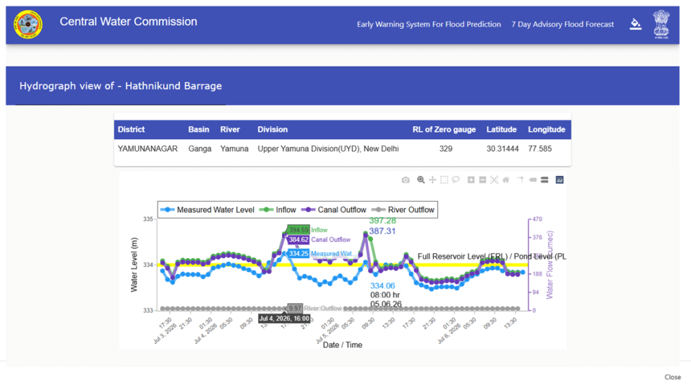
DRP News Bulletin

DRP NB 150523: Will the govt listen to caveats against Ken Betwa Project?

The following report raises three caveats regarding Ken Betwa River Link Project, among others. Firstly it urges that the substantial impact of climate change on the rivers needs to be taken into account, particularly the need for accurate hydrological assessment. It underlines that the project themselves are accelerating the climate change impact on monsoons as they are reducing freshwater flows to the oceans, which in turn has an impact on the ocean’s thermal and salinity gradients, both of which are drivers of monsoon.

Secondly, it rightly says that the impact of projects on adaptive capacity of areas like Bundelkhand needs to be taken into account. In Bundelkhand, climate adaptation can be harnessed using rain water harvesting, rejuvenation of traditional water systems, less water intensive crops and alternative agricultural practices. Thirdly, the water sharing issues that may worsen with both climate change and big projects, need to be kept in mind while taking up mega projects, particularly its impact on water and other security issues.

Continue reading “DRP NB 150523: Will the govt listen to caveats against Ken Betwa Project?”
Dams

Haryana Rivers Profile

Summary of Rivers in Haryana                                                                              

About Haryana

Location: Northwest India, Carved out of Punjab in 1st November 1966; Area: 44212 sq km. Mostly Gangetic/ Trans-Gangetic Plains; Population: 253.53 lakhs (2011); 4 River Basins, 21 Districts; Climate- Arid to semi-arid with average rainfall

Rivers in Haryana fall mainly within Indus and Ganga basins. River Ghaggar sub basin and its tributaries in the west of the state caters to the Indus basin, while river Yamuna and its tributaries in the east make up the portion of the Ganga basin. 

Continue reading “Haryana Rivers Profile”

Dams · Ganga

Haryana Rivers Profile: (Part-II – Ganga Basin)

Yamuna Basin:  River Yamuna[1] accounts for 7.10 % of the total geographical area of the country. The Haryana state forms 6.5%[2] of the river basin. It drains an area of 366,223 square km in the Gangetic plain and constitutes 40.2% of Ganga Basin. The river annually carries 10,000 cubic billon meters (CBM) of water of with 4400 cbm is used for irrigation.  Yamuna river basin forms the upper sub-basin of Ganga river[3] the total area of which is 35798.19 square km comprising of 47 water sheds. 

Yamuna river originates from Bandar Punch glacier in Uttarkashi district of Uttarakand. The river flows through about 200 kilometers before reaching Haryana State at Shivalik Hills in Yamuna Nagar district. In the same district the river is trapped in Hathini Kund Barrage located in Kalesar National Park.

Continue reading “Haryana Rivers Profile: (Part-II – Ganga Basin)”