Above: Standing at the edge of a river island, the Gaga river upstream of Farakka barrage seems to stretch out forever like the sea (Photo by Siddharth Agarwal)
GUEST BLOG BY: Siddharth Agarwal
The monsoons had begun their annual ritual about the same time I found myself bereft of my old company while walking along the Ganga from Ganga Sagar to Gaumukh[i]. The documentary crew that was traveling along with me had decided against venturing into the states of Jharkhand, Bihar and Uttar Pradesh, hence I ended up travelling alone upstream from Farakka.[ii],[iii]Continue reading “Farakka Refugees: Walking along Ganga from Gangasagar to Gaumukh”→
अत्यधिक दुखःद समाचार है कि अनुपम मिश्र जी नहीं रहे। 19 दिसंबर 2016 को प्रातः 05:27 पर दिल्ली के एम्स अस्पताल में उनका देहांत हो गया।
पानी के मुद्दों और भारत की नदियों पर स्पष्ट विचारों वाले, सरल किंतु प्रभावशाली भाषाशैली के धनी, अत्यंत उदार और विनम्र अनुपम जी समान व्यक्तित्व दुर्लभ है। जैसा रवि चोपड़ा जी ने कहा है वे सही में अनुपम थे।
अनुपम जी भारतीय नदी सप्ताह 2016 के आयोजन समिति के अध्यक्ष थे और वर्ष 2014 भगीरथी प्रयास सम्मान चुनाव समिति के सदस्य थे और वर्ष 2015 में इस समिति के अध्यक्ष बने।
खराब स्वास्थ्य के बावजूद वे भारतीय नदी सप्ताह की आयोजन समिति की बैठकों में वे लगातार उपस्थित रहें, अंतिम बार सितंबर 2016 की बैठक में वे मौजूद थे और भारतीय नदी सप्ताह 28 नवंबर 2016 के शुभांरभ के समय भी वे उपस्थित रहे , जहॉ पर हमेशा की तरह उन्होने अपना सरल, स्पष्ट किंतु मर्मस्पर्शी व्याख्यान दिया। वे शाररिक रूप से थके और कमजोर थे , इस सबके बावजूद वे आए जो पर्यावरण के प्रति उनके समर्पण की मिसाल है।
व्यक्तिगत तौर पर वे मेरे (हिमांशु ठक्कर) प्रति बहुत उदार थे और मुझे हमेशा प्रेरित करते रहते थे। हमने कभी भी नहीं सोचा था कि एक दिन हमें उनसे अलग होना पडेगा। उनके चले जाने से देश और पर्यावरण को हुई क्षति की भरपाई नामुमकिन है। परंतु उनकी प्रकृति शिक्षा और अनुभव उनके द्वारा रचित स्पष्ट, सरल और सारंगर्भित लेखों और पुस्तकों के माध्यम से हमेशा हमारा मार्गदर्शन करती रहेंगी।
किताबों के समान उनके व्याख्यान भी ज्ञान और अनुभव से भरे हुए प्ररेणास्रोत है। उनके दिखाए मार्ग पर आगे बढ़ते रहने के लिए, दुख की घड़ी में हम, उनके द्वारा भारतीय नदी दिवस (28-30 नवंबर 2016) में दिए गए उनके अंतिम व्याख्यान को, उन्हें श्रृद्धांजलि के तौर पर अर्पित करते हुए, आपके साथ सांझा कर रहे हैं ।
To provide much-needed succour to those reeling under severe drought and facing acute drinking water shortage, as part of temporary drought-mitigation measures, the district administration has established helplines in all seven taluks.
A look at impacts of failing Northeast Monsoon on 4 South Indian States
South IndiaNortheast Monsoon Failing; Water Crisis To Become WorseAndhra, Tamil Nadu, Kerala & interior Karnataka generally receives good rains during the Northeast Monsoon period that commences from Oct until Dec. However, this year, rains have remained scantyover entire Southern India region. Northeast Monsoon has also set in quite late during Oct end. As of now excluding scattered rain events, Monsoon like heavy rains are still far from coming to the southern region of the country. This is a clear indication of possibility of drought-like conditions that might prevail over south peninsula during Northeast Monsoon. In a nutshell, the picture is not very encouraging for next few days and also any significant increase in rains are not foreseen over the southern regions of the country.
India River Week-2016 to focus on State of India’s RiversSince time immemorial, rivers have held a coveted place in the mindscape of Indians. Rigveda has dedicated suktas on mighty rivers like Sindhu describing not only the river, but its tributaries, its flow, its myriad paths, the glaciers and lakes which feed it. Across India, local cultures are replete with evocative river stories, river festivals and several rituals which bring rivers in the homes and hearts of people. And yet, Indian rivers remain some of the most abused in the world.
It’s natural for rivers to be in the news during the monsoon or a drought, but that is not the only reason why rivers are being discussed these days.
Rivers are indeed grabbing headlines, be it Cauvery or the Indus or the mindless plan of River Interlinking. But while that happens, are we discussing rivers at all? We are discussing conflicts and interstate issues, even geopolitics, but we have very successfully cut our rivers and the hydrological systems including the catchment, headwaters, groundwater, wetlands, lakes and estuaries into convenient pieces: water supply, water sharing, irrigation, hydro-power, drinking water supply, sanitation, pollution, flood control. It seems, most of the time, rivers are in the news for all the wrong reasons!
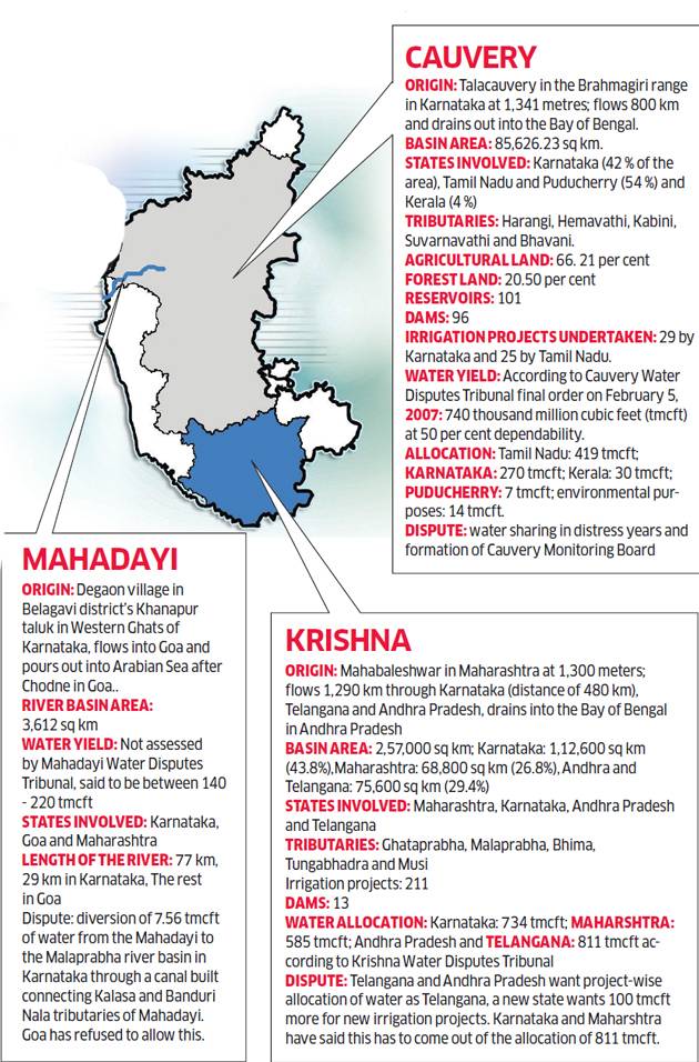
For example, the Cauvery is in the news for the never-ending dispute between Karnataka and Tamil Nadu on sharing of its waters, a conflict that keeps rearing its head whenever there is a deficit year. Unfortunately, the dispute is about the Cauvery, but the poor river’s condition is on no one’s radar. Everyone is only talking about its water!
Similarly, Mahanadi is in the news for interstate water disputes. But none of states is particularly worried about the condition of the river. In the case of the Mahadayi, again, the states seem least bothered about the river itself, with Goa planning to allow navigation on it without any assessment of its impact on the river. Telangana and Andhra are locked in Krishna and Godavari water-sharing disputes, which are bound to spill over to Maharashtra and Karnataka, among other basin states.
NationalThe cost of cheap drugsThe Bollaram-Patancheru region in Hyderabad, Telengana is famous for being one of the most polluted industrial areasin India. The periphery around the area has become so toxic one that 2001 article recommended that “most of the soils should be removed from agricultural production” in Patancheru. There is an increase in higher abortion rates to birth defects and stunted growth in children, as well as greater incidence of skin diseases in the region. In the district of Medak in the state of Telangana, Greenpeace in its several reports has identified that people, animals, crops and land have been afflicted by the pollution of industrial waste. Villagers report many serious health issues, including miscarriages, skin disorders, cancers and intestinal problems. The livestock suffer from the same problems. Most, not to say all, food grown in the village is unfit for human consumption. An inspection report published by CSE in November 2015 noted that most companies in Pattancheru-Bollaram were manufacturing pharmaceutical ingredients for which they did not have permission; using more water than the permitted limit and dumping more hazardous waste than allowed. Two of the units were operating without clearance from authorities.
In the case of the Ghaggar river in Punjab, all along its river course, one can witness foul smell, contamination of subsoil water, spread of water borne diseases and chances of damage of crop due to the presence of industrial chemical waste due to industrial waste from the industries in Punjab and Himachal. Media reports report similar occurrences around the Bhiwadi belt, where pharmaceutical companies discharge untreated effluents into drainages which then seep into the groundwater, making way into drinking water supply and agricultural land, resulting in environmental and health risks of unimaginable proportions.
In many low and middle income countries, weak laws and ineffective regulatory bodies have led to rising incidences of industrial waste flowing into ponds, lakes and rivers. If we examine the causes, the role of the pharmaceutical industry is similar to printing, chemical and paint industries. Pharma effluents contain hazardous chemicals which are leading to antimicrobial resistance or AMR where the human body is resistant to antibiotics, and thus, becomes susceptible to common infections. The very same ingredients used to manufacture antibiotics get mixed up with the bacteria during waste disposal, through our waters. Studies have shown that high levels of antibiotics are found in streams and lakes in the area close to many plant than in the body of human beings. The phenomenon is such that it is assuming the form of a serious public health issue in developing as well as developed countries. Over 700,000 people die every year because of antimicrobial resistance (AMR) all over the world. If this trend persists and resistance continues, McKinsey studies has shown that by 2050, around 10 million people globally will die because of AMR (Antimicrobial Resistance)
It is pertinent to note that New Delhi metallo-beta-lactamase superbug (NDM-1), a bacteria, first found in New Delhi’s public water supply in 2008, is resistant to almost all known antibiotics and has spread to over 70 countries in the world.
On the other hand, scientists from multiple institutes having done a detailed study on river pollution concluded that arsenic in the study areas poses potential health risk to the residents and indicates that the “ingestion of water over a long time could magnify the probabilities of cancer. They collected and assessed concentrations of 27 trace elements in surface water samples from 48 sites of waterways (lakes, canals, and tributaries of major rivers) in four states: Karnataka, Tamil Nadu, Kerala, and Telangana. Analysis revealed that elements such as chromium, selenium, arsenic, iron, and manganese are the major pollutants, as their concentrations exceeded the acceptable national and international water quality standards in several sites of Vrishabhavathi, Ennore, Adyar, Cooum and Periyar rivers. Further, statistical analysis revealed that the Cauvery, Ennore, Adyar, Cooum and Periyar river basins are affected by various anthropogenic activities, leading to moderate-to-high pollution by arsenic, chromium, manganese, iron, and selenium. According to the scientists, potential pollution sources are industrial waste, sewage intrusion, paint industry waste, and automobile runoff.
Big Dams Ineffective & Destructive, Will Involved Villagers In Building Small Check Dams: CM JharkhandOn Oct 21 making an important statement during a meeting in Jharkhand CM Raghubar Das has said that State Government will not construct big dams and will go for smaller check dams. While addressing the Asanpahari villagers in naxal affected Kathi Kund, the CM also said that he was against big dams as they entail catastrophic and cascading impact on environment and local people. Admitting that big dams have not benefited the farmers, he criticized the former Congress Government for allowing construction of big dams.
The CM has also made another important announcement that villagers would be involved in the construction of smaller check dams to meet water need for irrigation. Announcing funding of 15 small water recharge ponds in every village, he also stated that villagers will be be financially assisted to develop their own plan for construction of check dams. He also urged villagers to produce electricity from Bio-Gas and use its by-product the sludge as manure in fields.
Jharkhand CM here is making an interesting CLEAR statement that big dams have not helped Jharkhand and they would prefer to go for smaller dams.
झारखंड में अब बनेगा छोटा डैममुख्यमंत्री ने काठीकुंड के उग्रवाद प्रभावित गांव आसनपहाड़ी में विशेष ग्रामसभा में कहा कि सरकार राज्य में अब बड़े डैम नहीं , चेकडैम बनायेगी. सरकार बड़े डैमों की पक्षधर नहीं है. उन्होंने कहा कि कैसे बड़े बांध का बजट हनुमान की पूंछ की तरह बढ़ता जा रहा है. कई योजनाएं दशकों से अधर में हैं. सीएम ने कहा की बड़े डैमों से इस राज्य के किसानों को फायदा नहीं हुआ. कांग्रेस के राज में बड़े-बड़े डैम बने. गांव हमारा डूबा, लेकिन फायदा बंगाल को होता रहा. अब सिंचाई की जरूरत को देखते हुए गांव के लोग फैसला लेंगे. चैकडेम कहां बनेगा, यह गांव के ही लोग तय करेंगे. अपनी जरूरत के हिसाब से वे योजना बनायेंगे. इंजीनियर भी रांची का नहीं, इसी इलाके का होगा. सीएम ने कहा : इस इलाके में बरसात कम नहीं होती. सारा पानी बंगाल से होकर समुद्र में चला जाता है. बोरा बांध बना कर भी गांव में पानी रोका जा सकता है. उन्होंने हर गांव में 15-15 डोभा बनाये जाने की भी घोषणा की. कहा कि इसका पैसा भी सरकार देगी. सीएम ने कहा की गांवों में अब गोबर बैंक बनाये जायेंगे, जहां गांव भर से गोबर उठाया जायेगा. गोबर गैस प्लांट में बिजली पैदा की जायेगी, जिससे स्ट्रीट लाइट जलेगी और जो अपशिष्ट बचेगा, उससे जैविक खाद बनाया जायेगा. गोमूत्र का भी उपयोग खाद में किया जायेगा.
HYDRO POWER
SANDRP Blog Amid repercussions, PM inaugurates 3 HEPsPM Modi, on Oct 18 has dedicated to nation 3 big hydro projects namely the 800 Mw Kol Dam, 520 Mw Parbati & 412Mw Rampur in Himachal. All these HEPs have been involved in several controversies right from the day of inception. These projects were given clearances in questionable manner and even have not gone through proper EIAs. The resultant impact on environment, Rivers, and local communities has been catastrophic. The projects have been facing prolong, unending protests & stiff resistance from locals. Here is a brief description of all three projects along with short description of damages they caused and community driven protest they have been facing. Also listen to a AIR discussion on hydro projects in India in view of the PM dedicating Himachal HEPs. The discussion included SANDRP coordinator and Kirtika Suneja of Economic Times. Please share your feedback and send it to others who may be interested.
It is worth mentioning that the first-ever Disaster Analysis & Management reportcompiled by the Himachal govt emphasises the high vulnerabilityof major parts of five districts of Kangra, Chamba, Hamirpur, Kullu and Mandi to earthquakes. The projects under discussion lie in the very districts mentioned in the report. It also points out that though the state is prone to many hazards, earthquakes can pose a serious challenge. Similarly, according the latest study confirms that there is accelerated glacial melting in all the river basinsof Chenab, Ravi, Beas, Sutlej. The the number of lakes has gone up in all the basins. In the Sutlej basin the number has remained stagnant at 391 in last two years, but one cannot overlook the fact that the number of lakes in the Sutlej basin rose from a mere 38 in 1994 to 390 in 2015. Raising alarm bells on unabated hydro projects in Himalaya, one more report concludes that of the 177 hydro projects located close to Himalayan glaciers over a fifth including many in India could be under flood threat caused by the outbursts of glacial lakes, European researchers have warned. Most of the sampled hydropower projects are in the Indian Himalayan states of Himachal, Uttarakhand and Sikkim, and some in Nepal and Bhutan.
Meanwhile, several Himachal NGOs under the aegis of Himdhara & Himalaya Niti Abhiyaan have sought moratorium on dams, mega hydro power projects. Urging PM to announce a green development package for Himachal instead of special industrial package being sought by everyone, the organisations said such development projects have reported high negative impact on local eco system, environment, river system, forest, triggered landslides, increased erratic weather pattern and negatively impacted agriculture and horticulture.
On the contrary, there are news reports claiming that Govt of India may override environment concerns to pursue hydro projects in Himalayan region. The report quotes a senior water ministry official saying as “It has been realized that we have lost a lot of time in developing hydropower in the northeast. We need to move fast to establish our right on water from rivers like Brahmaputra that are coming from China. There are some genuine environmental concerns but they are not more important than our country’s strategic concerns. This is the time to take hard decisions. Indeed, Himalayan rivers have also become the new flash pointin the bitter India-Pakistan conflict, providing the latest diplomatic weapon in PM Modi’s push to isolate Islamabad.
HimachalReturning Power to PeopleThe Kashang project is just one of many in Kinnaur which has led to the landscape being torn apart pieces of its hollowed mountains, sliding, cracking and quaking every other day. Little wonder that the people of the region welcomed the NGT judgment. For a people, who have paid the cost of this “development”, without ever being considered as “decision makers” in the process of planning and impact assessment, the NGT judgment validated their connection with their landscape and culture. A report by Himadhara.
J&KExamining hydro projects economy of the StateThe author of this piece could have calculated the power generated by all existing hydropower projects in the state (irrespective of ownership) and asked why this power should not be made available to the people of the state?
RIVERS
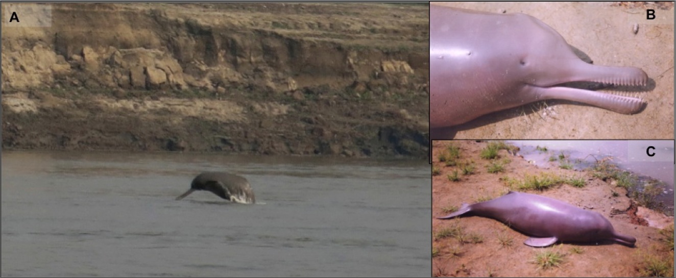
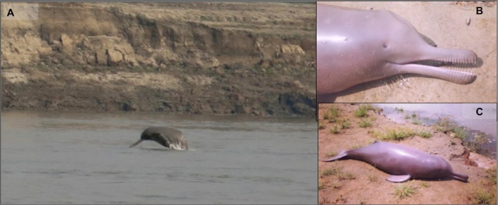
(A) An image showing the Gangetic dolphin in its wild habitat (photo credit: Kadambari Deshpande), (B) a dead Gangetic dolphin calf (notice the pinhole like eyes), and (C) the calf is 1 m long, and adults measure to 2.6 m (photo credits for B & C: Sushant Dey).
SANDRP BlogDo we care for river dolphins or their habitat?Nachiket Kelkar, in a Guest blog for SANDRP discusses the statement of Union Water Resources Minister Sushri Uma Bharti about Ganga Dolphins turning blind due to pollution.
GANGA NGT No one knows how many drains pollute GangaThe observation came after the CPCB told the NGT that there were 30 main drains which joined Ganga or its main tributaries like East Kali, Kosi and Ramganga falling in the segment from Haridwar and Unnao. However, UP Pollution Control Board claimed there were 172 drains, of which 150 directly joined Ganga and its tributaries. According to UP Jal Nigam, there were 172 drains out of which 83 terminated in the Ganga. The tribunal has asked MoEF, CPCB, UP state pollution board & Jal Nigam to clarify their stand on zero liquid discharge, online monitoring of effluents and discharge of waste in drains by industries releasing contaminants in Ganga. The Green Tribunal also has rapped UP govt for wasting crores of rupees of public money on Ganga rejuvenation & restrained it from spending on any major project except maintenance work on the stretch from Haridwar to Kanpur. UP govt had told the NGT that as per estimates, at present 1382.36 MLD sewage is generated and only 300 MLD get treated in treatment plants. The UP Pollution Control Board on Oct 20 informed the Green Tribunal that a “flood” of multi-storeyed buildings have been constructed on the floodplains of Ganga and Yamuna over the years without devising any mechanism for waste disposal. It also told that floodplains have been encroached upon in Delhi, Noida and Greater Noida to build apartments and housing societies. Local authorities take money and grant them permission to discharge all the waste into the sewer lines. The court was also informed by advocates that there were almost lakh industries between Haridwar & Kanpur segment. However, according to CPCB there are only 1072 industries. The bench also asked it to file details about the existing STP and CETP and inform whether they were functional or not and also state whether they were capable of treating various pollutants, sewage and bacteria. According to a news report, mining on Ganga River bed in Uttarakhand continues, with approval from both centre and state govt. Meanwhile, there is news that Sonipat administration will inquire into the complaints of diversion of the Yamuna watersallegedly by two mining contractors near Tikola village in the district. A case has also been registered at the Murthal police station in this regard.
KarnatakaVillagers caution authorities over Malprabha pollution The releasing of sewage water to the Malaprabha river by Khanapur town panchayat authorities has been creating health related problems to the people in lower riparian villages. Irked with the problem, villagers have cautioned of locking town panchayat office if the releasing of effluent to river not stopped immediately.
Also seeProtecting 6 riversby S. VishwanathProtecting the ecology and the environment of the ranges will protect the rivers and fresh water. This will also help an orderly development of the place in a sustainable fashion. Unless an institution is created and armed with powers to manage this sensitive area we will see the gradual demise of a culture centered around water and the death of six rivers. The time to act is now and that would be water wisdom.
GujaratNHRC issues notices to govt over complaints of pollutionThe commission reacted to a complaint filed by Paryavaran Mitra, an NGO, pivotal in enforcing, environmental public hearing mandatory in the state. The commission has asked the state govt to file a reply within four weeks. The complaint submitted a CAG reports of 2015 and 2011 regarding Gujarat’s status of Common Effluent Treatment Plant (CETP). The reports stated that “None of the CETPs in Gujarat discharged their effluents as per the prescribed norms by the GPCB and wide variations were also noticed in the performance of CETPs.” Will NHRC do anything significant? Very doubtful, considering past examples, but helps highlight the issue.
DROUGHT OPTIONS
MaharashtraSolapur holds key to water-stressed MarathwadaThe patchy soil and water conservation efforts of the govt seem to have learnt nothing from the exemplary measures undertaken in Solapur district. Great to see this public appreciation for dynamic and innovative efforts by Tukaram Mundhe and his team in Solapur during 2015-16 drought.
DROUGHT 2016
Kerala Attappady in firm grip of droughtThis region in Palakkad has recorded 90% deficit rain in southwest monsoon. According meteorologists the area would not receive much rain even during the ensuing northwest monsoon. The perennial rivers Bhavani & Siruvani are a trickle now, much ahead of the summer months. The Kodukarampallam river has dried up. The heat wave has affected the cultivation of pulses & millets in Mulli, Kottathara, Sholayoor and Kadampara. Most tribal settlements face acute scarcity of drinking water. Most wells in eastern Attappady had turned dry. In others, the water level had depleted alarmingly. Palakkad district in Kerala, even with over 1000 mm of rainfall in monsoon, though with a deficit of huge 34%, is in grip of drought like situation with fast depleting dam stroages.
OdishaDrought manifests in 5 districtsThe specter of drought is looming over Deogarh, Sambalpur, Sonepur, Jharsuguda and Bolangir as these districts have received the less than average rainfall in the monsoon. In Bolangir district, paddy fields are wilting due to lack of water. A drought-like situation is already a reality in areas like Tureikela, Bangomunda, Muribahal, Saintala amongst others in Titlagarh subdivision of Bolangir district which have received less than 27% of the normal rainfall.
AndhraWorst ever drought hits APEven though cumulative rainfall from June 1 to October 19 deviated 17 per cent from the actual rainfall, which is considered normal, the number is likely to be higher than last year’s 359 mandals. While more than 500 mandals faced a drought-like situation till September, heavy rainfall in the second and third weeks, which resulted in flooding, brought down the number to 300-310.According to this report, Andhra is facing worst drought, worse than the last year. Some 370 mandals facing drought, but state is yet to declare drought.
DAMS
MaharashtraTadoba tigers under threat from Human dam projectConservationists have questioned the need for Human project after 33 years, especially when 20-22 major and minor irrigation projects like Gosikhurd, Ghodazari, Asolamendha and Nalleshwar have come up in Chandrapur district. Besides, the district has taken a lead in Jalyukt Shivar for which 41 cr have been approved. Another unjustified DAM threatens Another Tiger Reserve, this time is Human Dam in Wainganga-Godavari basin in Chandrapur district, threatening the Tadoba Andhari Tiger Reserve, hanging for 33 years thanks to contractor driven politicians-Engineer-bureaucrat lobby. The project will again be discussed at Maharashtra State Board of Wildlife on Oct 26, but basic documents are still not available to SBWL members.
MPDamning report on rehabilitation A massive scam involving the distribution of compensation to fake beneficiaries in MP is likely to crush the BJP’s hope of making political capital from the completion of the construction of the Sardar Sarovar Dam in Gujarat by Dec 2016. The compensation was meant for those who will be displaced when the dam’s height is raised. Gujarat’s chances of getting permission from the Supreme Court and Narmada Control Authority (NCA) to close the erected gates to store more water now appear bleak given that MP’s poor rehabilitation record has been completely exposed by a judicial inquiry. It is also strange that Gujarat minister is not bothered about the injustice to the affected people or the corruption and waste of public resources, he is only interested in getting permission to fill up the reservoir. Meanwhile Congress on Oct 19 alleged that the BJP govt in MP is in the thick of a “scam of monumental proportions” in the resettlement and rehabilitation of the oustees of the Sardar Sarovar project on the Narmada. It further said that PM Modi & the Gujarat BJP govt were compromising the interests of the peopleof Gujarat to save Shivraj Singh Chouhan’s BJP government in MP from the fallout of the resettlement and rehabilitation (R and R) scam there. Quoting the Justice Shravan Shankar Jha commission report, the party claimed that the funds meant for relief and rehabilitation of more than 40,000 families affected by the Sardar Sarovar project had been misappropriated.
INTER-STATE WATER DISPUTES
Krishna RowNo relook into allocation of water: TribunalThe tribunal pronounced its judgement on the litigation prompted by AP and TS arguing that Section 89 in the AP Reorganisation Act meant redistribution of Krishna water among all the four riparian States not just between them at New Delhi on Oct 19. In its verdict, the tribunal said Section 89 was not applicable to all four States but meant only for TS and AP. Further, it has asked TS and AP to come before it on December 14 with claims on sharing of water between the two out of the allocation made for combined AP by the tribunal already.
KarnatakaState faces water dispute issue with six states While water shortages and the need for drinking water and widening the area under irrigation are real concerns for Karnataka, the issues have been largely politicised and have become feeding trough for political parties in the basin regions, depending on which party is ruling and which is not in the respective states and the Centre. Karnataka has just gone through over a month long crisis over sharing the Cauvery waters with Tamil Nadu and Puducherry after the south-west monsoon in the state failed this year. Goa, where the Mahadayi is known as the Mandovi and is a lifeline for the state, has opposed this demand, citing ecological damage to the river. On the Krishna front, the new stat of Telangana asked for an additional 100 thousand million cubic feet (tmcft) of water for new irrigation projects.
INTER-LINKING OF RIVERS
KBLGetting clearances for Ken-Betwa will not be difficult: UmaThe Water Resources Minister keeps making pre-emptive statements about environment clearance to Ken Betwa link project, even talks about reconstitution of Expert Appraisal Committee, which provides a hint about what is the objective of EAC reconstitution.
FLOOD 2016
BiharState seeks Rs 4000 cr from Centre in flood damages At least 88 lakh people in 31 districts across the state were affected and 254 were killed, adding that 3.65 lakh hectares of land were submerged, causing extensive damage to crops. Out of the 31 flood-affected districts, 12 districts including Patna, Begusarai and Bhagalpur felt the maximum impact of the furious Ganga. The Ganga, which rose to a record level of 50.50 metres at Patna, over topped its banks at many points. The state had demanded Rs 14,846 crore when the Kosi embankment at Kusaha in Nepal had breached in 2008, causing untold miseries in all north Bihar districts and killing over 350 people. The then UPA government at the Centre had conceded a grant of Rs 1,000 crore.
IRRIGATION
ChhattisgarhVillagers protest against irrigation projectVillagers have come out in protest against the Gagar irrigation project in Chhattisgarh’s Balrampur district. The villagers said the special gram sabha convened for the project in different villages had refused the plan. Despite the protest, the district administration is allegedly planning to forcefully acquire the land for the project. Under the banner of Chhattisgarh Kisan Sabha and Adivasi Ekta Mahasabha, the villagers marched out a rally in Ambikapur, the divisional headquarters of Sarguja. A memorandum was given to the district authorities. The officials however did not comment on the development.
Centre Water ministry released ABIP first installment Union Water Ministry on Oct 21 announced to release of first installment of Rs. 1500 crore to the states as central assistance for 99 prioritized irrigation projects under Accelerated Irrigation Benefits Program (AIBP). This amount has been released for 50 projects in the states of Gujarat, Karnataka, MP, Maharashtra, Manipur, Odisha, Punjab, Rajasthan and Telangana.
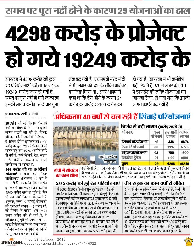
Massive irregularities in Jharkhand irrigation projectsAccording to this Oct 20 news report from Prabhat Khabar there has been scams, delays and irregularities of monumental scale in several irrigation project in the State.
AGRICULTURE
MaharashtraDrought-stricken farmers plant thirstiest crop Without govt intervention to reset the revenue balance in favour of other crops, experts warn the sustained production of sugar cane will further deplete scarce water resources and leave the region prone to droughts. This could create social unrest stemming from the widening income gap between cane growers and other farmers. Govt hopes higher subsidies for pulses and oilseeds will change farming patterns. But industry critics said the pulse and oilseed MSP only exists on paper as the government never procures them aggressively like wheat or rice. Story explains why farmers prefer growing thirstiest crop in drought affected region & its implications.
On the other hand, despite satisfactory rainfall this monsoon, farmer suicides have not gone down in the State. As many as 2307 farmers have killed themselves till now, in 2016. The number is 45 more than number of suicides reported during the corresponding period in 2015. The suicide rate this year has been much higher than that in 2012, 2013 and 2014 the years of acute water scarcity. 1473, 1296 & 1981 farmers committed suicide in these years, respectively. 2015 had witnessed highest ever suicides – 3228.
There is one big article which initially seems to give an impression of a revolution happening in agriculture marketing in Maharashtra. The changes are indeed significant and it has all the seeds of a revolution, but so far the reformed markets outside APMC cater to only about 2% of agri market share, which shows that a lot more would need to be done before that potential becomes a reality. Pune, it seems at the hub of farmer-consumer market for vegetables and fruits, may be some Pune friends can throw more light.
Meanwhile, Ministry of Agriculture and Farmers Welfare in its latest publication titled State of Indian Agriculture (2015-2016) seeks to present analysis of the recent growth and performance of the agriculture and allied sectorsand also to analyze the major emerging challenges.
SAND MINING
Tamil NaduVillagers protest against mining proposal in Kollidam riverA group of people from two villages in Lalgudi taluk came to the district collectorate in Trichy to submitting a memorandum opposing the proposed commencement of sand quarry in Kollidam river here on Monday. They alleged that illegal mining in Kollidam river upto 40 feet has affected their cultivation owing to depleting ground water table. They cautioned that it would become a threat for the newly constructed Trichy-Thanjavur bridge across Kollidam, if the govt permitted sand mining further.
WETLANDS & WATER BODIES
J&KFesh algae boom threatens Dal lakeThe single most cause of the Dal’s deterioration over the years is the blocking of its natural drainage system as a result of the filling in of the Nallah Mar in the 1970s. The stream which passed through downtown Srinagar was fed by Dal and helped in the circulation of the lake’s water. Loss of Nallah Mar choked Dal. The process of relocating Dal dwellers has been exceedingly slow. Despite all these measures, Dal is showing fewer signs of being on the road to recovering its old glory. The resurfacing of red algae has come as a reminder that something somewhere is seriously amiss.
RENEWABLE ENERGY
IndustryRenewable energy firms worry about back-down by power discomsNo PPAs are getting signed, signed PPAs are not being honoured, renewables are asked to back down, all negative signs for solar and wind developers, this affects even big players like Tata and Adani, among others. How will the advocacy for brining big hydro help in this scene? The scene is only going to further worsen in days to come.
REST OF THE WORLD
VietnamDam made floooding worseLocal officials are blaming the operators of the Ho Ho Hydroelectric Plant for making the deadly flooding in Vietnam’s Ha Tinh Province worse by suddenly releasing water held back by the dam. Flooding in Vietnam is being blamed for killing at least 25 people and destroying thousands of homes, as the country braced for even further destruction with typhoon Sarika closing in on the country. Sudden release of large quantity of water without information in the downstream area when the downstream areas were facing floods leads to avoidable destruction. Hope the investigation leads to truth.
ENVIRONMENT
NationalIndia headed for coal power overcapacityDespite its proactive stance on climate action, India continues to invest in increasing electricity capacity fired by coal, much of which may never be used, says a new report, but some experts disagree. This article rightly says that India is heading towards unnecessary building of thermal power plants at such huge costs and impacts. On the other hand according Crisil, nearly Rs 1.34 lakh crore worth of debton operational and under-construction power projects is at risk. Unnecessary and unproductive investments in power sector means increased NPAs (Non Performing assets), decreased credits and high risk debts. This can be easily avoided with wiser decisions, and not running after large hydro or coal power. Also see,Turning India’s surplus power into a boonThis report suggests ways to increase electricity consumption in India! However, the author seems quite well informed.
Above: (A) An image showing the Gangetic dolphin in its wild habitat (photo credit: Kadambari Deshpande), (B) a dead Gangetic dolphin calf (notice the pinhole like eyes), and (C) the calf is 1 m long, and adults measure to 2.6 m (photo credits for B & C: Sushant Dey).
Guest blog by Nachiket Kelkar
In 2015, The Times of India reported on the Ganges River Dolphin census exercise conducted in Uttar Pradesh, with the picture of a water buffalo to pass off as a dolphin. If you do not believe this, check out the image below[i]. Generally, most news reports on the river dolphin, some even by reputed news outlets (e.g. http://alert-conservation.org/issues-research-highlights/2016/5/30/rivers-of-destruction-the-implications-of-indias-national-waterways-bill-for-biodiversity), show the wrong species of dolphins, mostly marine species jumping acrobatically in aquariums. A forest department officer told us during their preparations for the Wildlife Week that, “if we put a beautiful dolphin’s picture, people will get more attracted to conserving the Gangetic dolphin, which is quite ugly, and the poor thing is also blind – toh achcha nahin lagta hai (it does not look good).” It does not stop here. A senior ecologist expressed concern recently in a public lecture, about the river dolphin becoming blind due to pollution. Against this background it is clear how little we know the Ganges Dolphin (our National Aquatic Animal, mind it) even today. Continue reading “Turning Blind Eyes: Do we care for river dolphins or their habitat?”→
We have noticed during just concluded South West monsoon season that IMD (India Meteorological Department) has started a new and welcome feature in rainfall data reporting[i]. The Data is available in maps, on daily, weekly and seasonal basis. We are not sure when this practice started, we noticed it only during 2016 monsoon season.
This is most welcome development, since getting rainfall data at basin level is most appropriate and useful, since basin is the hydrological unit that will experience the impact of rainfall or lack of rainfall in the basin, in form of floods or droughts. It can also be very useful for flood forecasting and preparedness, among many other uses. We hope IMD will develop and refine this further.
In each map, the actual rainfall for the given period is given for each basin, as also the normal rainfall & % departure from normal. Usual colour code is used to show the basin as blue if rainfall is more than 120% of normal rainfall, green if rainfall is 81-119 %, brown if rainfall is 60-80% of normal and yellow if rainfall is below 60% of normal rainfall.
Is there any justification for DESTRUCTION of Panna Tiger Reserve? Can we save our Natural Heritage like the Panna Tiger Reserve (PTR) from being destroyed in the name of baseless, questionable, non transparent, undemocratic and manipulated projects like Ken Betwa inter linking ? It will facilitate export of water from Bundelkhand to OUTSIDE Bundelkhand. Whatever little benefits are claimed, some of them are already available and much more can become available at much lower costs, faster and without destroying the Forests and Tiger Reserve. The project will actually lead to destruction of Ken catchment and hence the Ken River itself. Watch this FASCINATING, AWESOME story of tigers of PTR. This BBC film where Raghu Chandawat is the story teller and Pradip Kishen is lending his voice, tells the story of Tigers of Panna till 2003, it seems. Please watch and let us all try to save it from destruction that is now writ large in terms of Ken-Betwa Link Project (KBLP). One more short film by wildlife biologist Koustubh Sharma illustrates how the Daudhan Dam under KBLP will submerge and destroy the PTR.
Meanwhile, a new analysis of rainfall data reveals that monsoon shortages are growing in river basins with surplus water and falling in those with scarcities, raising questions about India’s Rs 11 lakh crore plan to transfer water from “surplus” to “deficit” basins. According to Himanshu Thakkar of SANDRP river basin interlinking should be considered only after exhausting the local potential for harvesting rain, recharging groundwater, watershed development, introducing better cropping patterns (non water-intensive crops) and methods (such as rice intensification), improving the soil moisture-holding capacity and saving and storing water. Raising alarm over significant increase in ground water use, increasing reliance and fast declining ground water table, he warns that inter-basin links would actually reduce groundwater recharge because forests would be destroyed, the river flow stopped and the local systems neglected.
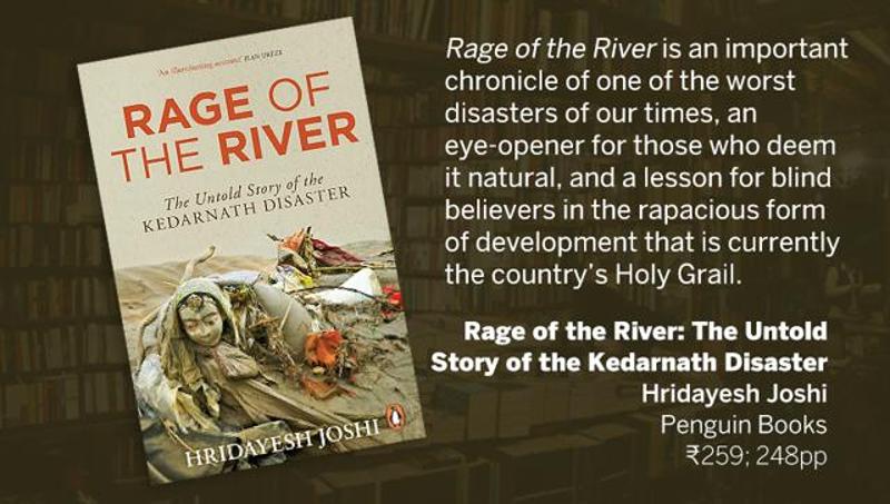
Book Review: Rage of the Rivers:Role of Uttarakhand hydro projects in Kedarnath disaster 2013by Hridayesh Joshi Rage of the River reads not unlike a gripping thriller. Thing is, it is not fiction. It is a true ‘story’ of a cataclysmic event, exacerbated by greed, and twisted notions of development manifested in blasting fragile hills, tunneling rivers, denuding forests, and encouraging illegal encroachments and mindless construction and tourism infrastructure. This is an important chronicle of one of the worst disasters of our times. Joshi has thoroughly analysed the role of endless, ill-planned hydel projects, but inexplicably fails to take into account the wreckage wrought by unrestrained tourism. Joshi points a finger at the unethical practices of construction companies, contractors and operators of hydel dam projects, even in the face of this monumental disaster. The officials of the Vishnuprayag project refused to listen to the pleas of the villagers to open the dam gates and allow the excess water to flow safely from under the barrage. The advice was ignored, either in ignorance of the gravity of the situation, or with an eye on the opportunity to generate more power. The rising waters broke the barrage flooding the valley and its villages.


")


")