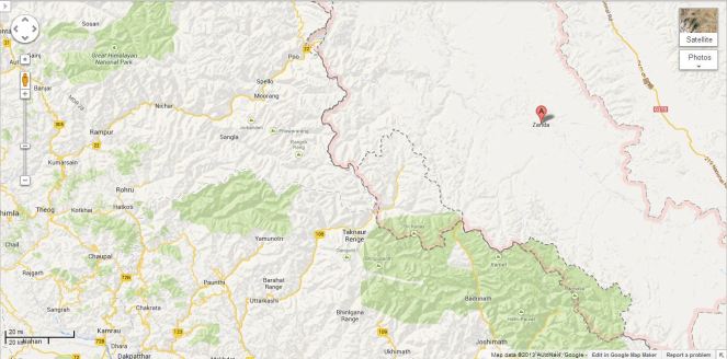
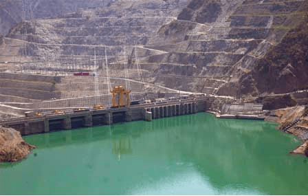
It is close to a year after the worst ever Himalayan flood disaster that Uttarakhand or possibly the entire Indian Himalayas experienced in June 2013[1]. While there is no doubt that the trigger for this disaster was the untimely and unseasonal rain, the way in which this rain translated into a massive disaster had a lot to do with how we have been treating the Himalayas in recent years and today. It’s a pity that we still do not have a comprehensive report of this biggest tragedy to tell us what happened during this period, who played what role and what lessons we can learn from this experience.
Floods in Uttarakhand Courtesy: Times of India
One of the relatively positive steps in the aftermath of the disaster came from the Supreme Court of India, when on Aug 13, 2013, a bench of the apex court directed Union Ministry of Environment and Forests (MoEF)[2] to set up a committee to investigate into the role of under-construction and completed hydropower projects. One would have expected our regulatory system to automatically initiate such investigations, which alas is not the case. Knowing this, some us wrote to MoEF on July 20, 2013[3], to exactly do such an investigation, but again MoEF played deaf and blind to such letters.
5 MW Motigad Project in Pithorgarh District destroyed by the floods. Photo: Emmanuel Theophilus, Himal Prakriti
The committee report, signed by 11 members[5], makes it clear that construction and operation of hydropower projects played a significant role in the disaster. The committee has made detailed recommendations, which includes recommendation to drop at least 23 hydropower projects, to change parameters of some others. The committee also recommended how the post disaster rehabilitation should happen, today we have no policy or regulation about it. While the Supreme Court of India is looking into the recommendations of the committee, the MoEF, instead of setting up a credible body to ensure timely and proper implementation of recommendations of the committee has asked the Court to appoint another committee on the flimsy ground that CWC-CEA have submitted a separate report advocating more hydropower projects! The functioning of the MoEF continues to strengthen the impression that it is working like a lobby for projects rather than an independent environmental regulator. We hope the apex court see through this.
Boulders devouring the Vishnuprayag Project. 26th June 2013 Photo: Matu jan Sangathan
Let us turn our attention to hydropower projects in Himalayas[6]. Indian Himalayas (Himachal Pradesh, Uttarakhand[7], Jammu & Kashmir, Sikkim, Arunachal Pradesh and rest of North East) already has operating large hydropower capacity of 17561 MW. This capacity has leaped by 68% in last decade, the growth rate of National Hydro capacity was much lower at 40%. If you look at Central Electricity Authority’s (CEA is Government of India’s premier technical organisation in power sector) list of under construction hydropower projects in India, you will find that 90% of projects and 95% of under construction capacity is from the Himalayan region. Already 14210 MW hydropower capacity is under construction. In fact CEA has now planned to add unbelievable 65000 MW capacity in 10 years (2017 to 2027) between 13th and 14th Five Year Plans.
Meanwhile, the Expert Appraisal Committee of Union Ministry of Environment and Forests on River Valley Projects has been clearing projects at a break-neck speed with almost zero rejection rate. Between April 2007 and Dec 2013[8], this committee recommended final environment clearance to 18030.5 MW capacity, most of which has not entered the implementation stage. Moreover, this committee has recommended 1st stage Environment clearance (what is technically called Terms of Reference Clearance) for a capacity of unimaginable 57702 MW in the same period. This is indicative of the onslaught of hydropower projects which we are likely to see in the coming years. Here again an overwhelming majority of these cleared projects are in Himalayan region.
Agitation Against Lower Subansiri Dam in Assam Source: SANDRP
What does all this mean for the Himalayas, the people, the rivers, the forests, the biodiversity rich area? We have not even fully studied the biodiversity of the area. The Himalayas is also very landslide prone, flood prone, geologically fragile and seismically active area. It is also the water tower of much of India (& Asia). We could be putting that water security also at risk, increasing the flood risks for the plains. The Uttarakhand disaster and changing climate have added new unknowns to this equation.
We all know how poor are our project-specific and river basin-wise cumulative social and environmental impact assessments. We know how compromised and flawed our appraisals and regulations are. We know how non-existent is our compliance system. The increasing judicial interventions are indicators of these failures. But court orders cannot replace institutions or make our governance more democratic or accountable. The polity needs to fundamentally change, and we are still far away from that change.
Peoples protests against Large dams on Ganga. Photo: Matu Jansangathan
The government that is likely to take over post 2014 parliamentary elections has an opportunity to start afresh, but available indicators do not provide such hope. While UPA’s failure is visible in what happened before, during and after the Uttarakhand disaster, the main political opposition that is predicted to take over has not shown any different approach. In fact NDA’s prime ministerial candidate has said that North East India is the heaven for hydropower development. He seems to have no idea about the brewing anger over such projects in Assam and other North Eastern states. That anger is manifest most clearly in the fact that India’s largest capacity under-construction hydropower project, namely the 2000 MW Lower Subansiri HEP has remained stalled for the last 29 months after spending over Rs 5000 crores. The NDA’s PM candidate also has Inter Linking of Rivers (ILR) on agenda. Perhaps we have forgotten as to why the NDA lost the 2004 Parliamentary elections. The arrogant and mindless pursuit of projects like ILR and launching of 50 000 MW hydropower campaign by the then NDA government had played a role in sowing the seeds of people’s anger with that government.
In this context we also need to understand what benefits these hydropower projects are actually providing, as against what the promises and propaganda are telling us. In fact our analysis shows that the benefits are far below the claims and impacts and costs are far higher than the projections. The disaster shows that hydropower projects are also at huge risk in these regions. Due to the June 2013 flood disaster large no of hydropower projects were damaged and generation from the large hydro projects alone dropped by 3730 million units. In monetary terms this would mean just the generation loss at Rs 1119 crores assuming conservative tariff of Rs 3 per unit. The loss in subsequent year and from small hydro would be additional.
It is nobody’s case that no hydropower projects be built in Himalayas or that no roads, townships, tourism and other infrastructure be built in the Himalayan states. But we need to study the impact of these massive interventions (along with all other available options in a participatory way) in what is already a hugely vulnerable area, made worse by what we have done so far in these regions and what climate change is threatening to unleash. In such a situation, such onslaught of hydropower projects on Himalayas is likely to be an invitation to even greater disasters across the Himalayas. Himalayas cannot sustain this onslaught.
It is in this context, that the ongoing Supreme Court case on Uttarakhand provides a glimmer of hope. It is not just hydropower projects or other infrastructure projects in Uttarakhand, or for that matter in other Himalayan states that will need to take guidance from the outcome of this case, but it could provide guidance for all kinds of interventions all across Indian Himalayas. Our Himalayan neighbors can also learn from this process. Let us end on that hopeful note here!
National Democratic Alliance (NDA) led by BJP’s Mr. Narendra Modi has been given a mandate to govern India for the next five years. Without going into the political and social facets related to this issue, there are a number of justifiable concerns about this government’s stand on critical issues of water and environment.
While the importance of water and environment sectors for the people, their livelihoods, society and economy is acknowledged, how crucial these sectors are for them is not easily appreciated. For example, environment is important not only for tigers and trees, but also for livelihoods of hundreds of millions of Indians who depend on natural resources. More than 60-65% Indians continue to depend on agriculture and every farm can benefit from better water resource management.
Some of the major challenges plaguing the water and environment sectors in India include: urgent need for an inclusive, democratic and accountable governance, holistic assessment of impacts the very many interventions in the Himalayas (lessons from Uttarakhand flood disaster of June 2013[1]), ecological restoration of Ganga and other rivers, dealing with climate change in a way that protects lives and livelihoods of the vulnerable sections, etc., to name a few.
The leaders of the party forming the new government have already declared their agenda in terms of completion of Sardar Sarovar Project (SSP) on Narmada, pushing interlinking of rivers (ILR), pushing for more dams in the name of irrigation, pushing big hydropower projects in North East India (Mr Modi had said in his campaign that NE is heaven for hydropower projects) and mega industrial initiatives like the Delhi Mumbai Investment Corridor.
This agenda indicates that the importance of water and environment to the vast millions is not understood. Nor is the significance of the challenges to this sector appreciated. Pushing the above agenda is not only fraught with serious risks in terms of social, environmental, economic and interstate issues, but these projects are not likely to deliver the promise of this party at the elections: Better life, more jobs, more development, fulfillment of basic needs of the people who do not have access to these at the moment. Pushing this agenda is not likely to deliver stated promises, however blind push for more and bigger projects will compound strife and conflicts.
Let us look at the issues related to the NDA Agenda. These are not incidental issues, but issues inherent to the nature of these centralized, mega projects themselves.
Does ILR have scientific basis? The basic premise of ILR is that certain basins are water surplus and others are water deficit. It is assumed that occurrence of floods in a basin means there is surplus water in the basin and occurrence of drought or water scarcity in other basin means it is water deficit. This premise itself is not scientifically, ecologically and socially robust.
While this is said, there is no attempt at assessing and exhausting the available water options in any basin in India. Twithout this exercise, there can be no scientific basis for declaring a basin surplus or deficit. The ILR advocates seem to ignore the reality that India’s water lifeline is groundwater and the best way to sustain groundwater is through local water systems and recharge. They also seem to ignore the massive social, environmental impacts and constitutional issues. ILR is basically a collection of large number of major irrigation projects (over 84), but proponents of ILR do not seem to realize that in last two decades, there has been no addition to net irrigated area by these projects, in spite of addition of thousands of new projects.[2]
“Sabarmati Model” holds no water for Ganga or other rivers During the elections in Varanasi constituency that elected Mr Modi, the issue of cleaning of Ganga remained prominent. BJP claimed that they will clean up Ganga at Varanasi the way they cleaned up Sabarmati River that flows through Ahmedabad in Gujarat. The trouble with this claim is that Sabarmati has not been cleaned up at all. The water flowing through Sabarmati as it flows through the city of Ahmedabad is actually the water of Narmada River, diverted into Sabarmati. Ahmedabad has no right over this water which was supposed to be meant for Kutch, Saurashtra and North Gujarat. If you go upstream along Sabarmati River from the point where Narmada Main Canal releases water in Sabarmati, you will see the reality of dry Sabarmati River. And if you go down to the Vasna barrage, downstream of Ahmedabad along the Sabarmati, you will see the state of polluted Sabarmati River. This model clearly holds no water either for Ganga or any other river.
River Ministry? There is speculation in media[3] that the new NDA government is going to create a new River Ministry at the centre. The same media report also stated that this ministry will push Inter Linking of Rivers (ILR)! This seems like a proposal for Ministry of River Destruction, since ILR is a recipe for destruction of rivers. If at all the new government is interested in an act of goodwill towards rivers, it needs to start with understanding what is a river and what are its various functions along the various stretches during various periods, including the social, ecological, economic, hydrological, geo morphological, biodiversity related, groundwater related and most importantly, livelihoods related functions. This exercise will mean understanding the roles of various arms of the government which affect the river. Some key ministries which affect river profoundly include: Ministry of Water Resources, Ministry of Environment and Forests, Ministry of Power, Ministry of Urban Affairs, Ministry of Rural Development, Ministry of Home Affairs (Disaster Management), Ministry of Agriculture, Department of North East Region, Ministry of Non Conventional Sources of Energy, to name only a few. How is this new proposed Ministry of River Going to coordinate with these ministries? Moreover, according to India’s constitution, Rivers are essentially state subjects and no state is likely to welcome such infringement of centre into what the states see as their domain of responsibility.
Ganga a National Project? There are statements from Mr Amit Shah[4], that the new government will give National status to the Ganga Project. It is not clear what is meant by this. Ganga is already under the Prime-Minister headed National Ganga River Basin Authority, but the Authority, five years after its constitution, has failed to change a single attribute affecting the Ganga. Similarly, Ganga River Basin Management Plan that IIT consortium is working on is already known to be pathetic in its understanding of the river, while pushing for privatization. We do not need another project in the name of Ganga, national or local. If the aim of declaring Ganga as a National Project is to wrest its control from the state, as the media suggests, then it is going to raise a lot of hackles.
What we need is a new approach to river governance, which is based on ecological, and not engineering principles, which is participatory, and not exclusive and which is democratic and not autocratic.
Himalayas & Hydro-onslaught Irrefutable evidence shows that building large number of major hydropower projects in Himalayas is having unprecedented impacts, some are known, many are unknown. The flawed environmental governance around these projects is well known in terms of dishonest EIAs, flawed and compromised appraisals, ineffective (these are consultations just in the namesake, in reality there is no basis for informed participation) public hearing and non-existent compliance, both at project and cumulative level. One implication of this was felt in terms of the role of such projects in the Uttarakhand flood disaster of June 2013, after which, no political leader from any party spoke about this. It was left to the Supreme Court to order and enquiry into this. The report of this investigation clearly indicates the role of hydropower projects in increasing the proportions of the disaster, and more work on this issue remains to be done. In North East itself, India’s biggest mass based public agitation against dams & hydropower projects has been going on. The anger of people has led to stoppage of the work on 2000 MW Lower Subansiri Hydropower project (largest capacity hydropower project under implementation in India) for 30 months now, after over Rs 5000 crores were irresponsibly spent by NHPC without completing even basic studies. Mindless pushing of more such projects in the region is clearly not a prudent move.
Source: MATU Jansangathan
BJP manifesto’s promise of expeditious and single window environment clearances is clearly dangerous in this context. What India needs is stronger and not weaker environmental governance. The advocacy[5] to “reduce time and transaction costs for the industry” under the circumstances seems inappropriate particularly from an organisation which was possibly the only environmental organisation represented on the completely flawed EIA registration process at Quality Council of India. The QCI process failed to achieve any improvement in the quality of EIA in almost 4 years of its existence
Sardar Sarovar Dam The new government wants to take the SSP Dam from its current height of 121.92 m to its final design height of 138.68 m. Firstly, there are serious doubts if this height increase is required since it can be shown that Gujarat and Rajasthan can get their share of water from Narmada without this increase in height. Secondly, Gujarat is not even in a position to use more than 20% of the water it already gets from the river at current height of the dam for the purposes for which the project was designed: providing water for the drought affected regions in Kutch, Saurashtra & North Gujarat. On the other hand, urban centres, industrials areas, SEZs, cosmetic river beautification schemes have appropriated a large chunk of SSP waters without legal, democratic sanction or justification. Gujarat really does not have a case for increasing the height of SSP Dam.
Moreover, this will also entail such massive additional submergence, displacement and disruption of lives of tribals and farmers that it is sure to create huge opposition. The just rehabilitation of already affected people is far from complete, in fact, most of the affected population has not been given minimum 2 ha of land required under the Narmada Tribunal award and subsequent accepted policies.
Mr Modi during his tenure of 13 years as Chief Minister of Gujarat failed to complete the canal network of SSP in the drought prone areas in whose name the project has always been justified. It needs to be noted that the agitation against SSP did not stop Gujarat government from going ahead with construction of canal network. It was not for lack of finances that SSP could not complete the canal network. SSP has been getting largest quantum of money from the Government of India’s Accelerated Irrigation Benefits Programme ever since the AIBP scheme started in 1996. This support to SSP from AIBP was clearly wrong since SSP was never the last mile project for which AIBP was meant, but the big dam lobby in Union Water Resources ministry and Gujarat government were hand in glove in this misallocation of AIBP money for SSP. In fact, Mr Modi arm-twisted the Planning Commission in 2011-12 to sanction the escalated costs for SSP even when the issues raised by Planning Commission officers remained unanswered.
Unused Narmada Canal waters flow into Salt pans, not only at a huge cost, but also affecting livelihoods of salt pan workers and the ecology Photo: Counterview
It is the ineptitude of Gujarat Government under Mr Modi that is on show in why it could not complete the canal network on drought prone areas in Gujarat. Mr Modi would do well to remember the reasons for that failure before he considers the mega projects agenda as Prime Minister.
Moreover, on SSP, the issues of completing repairs of the damages the Sardar Sarovar dam structure suffered four years ago & related issue of safety of the dam are yet to be resolved[6] and Gujarat has embarked on building another Garudeshwar Dam in immediate downstream without any impact assessments, participatory democratic process or required sanctions[7]. The legality of the Garudeshwar Dam work stands challenged in the National Green Tribunal by the affected tribals.
MAJOR RISKS FOR NEW GOVERNMENT Some major risks for the new government include: the track record of Gujarat government that Mr Modi headed for the last 13 years; no checks from coalition of parties; poor image, strength, morale and track record of Congress as the chief opposition party; large sections of almost completely subservient media[8] and BJP’s problematic manifesto[9].
Why UPA faced people’s anger The new government also needs to remember why the outgoing ruling coalition of UPA (United Progressive Alliance) lost so badly in spite of some unprecedentedly remarkable, and pro people steps taken by it. Absence of accountable and participatory governance (which also manifested in terms numerous scams) was one of the major reasons as to why there was huge anger in people’s mind about the UPA regime. Another aspect of corruption and high-handedness was apparent in the scandalous way UPA dealt with governance of environmental issues: blatantly changing its environment ministers from bad to worse.
Even if we leave aside the Rajas and Balus of UPA I, the UPA II began on a positive note with appointment of Mr Jairam Ramesh as environment minister. While we had our share of criticism of functioning of Mr Ramesh as environment minister[10], he was possibly the best environment minister India have had.
But under pressure from misguided and misinformed corporate vested interests, Mr Ramesh was removed (kicked upstairs) and Mrs Jayanthi Natarajan was brought in. She did not really help the cause of environment as is apparent, for example, from her answers to the two debates on Ganga river in Parliament (these debates were unprecedented in their own right) as also sanctioning projects rejected by statutory bodies like Forest Advisory Committee.
Strangely, she too was removed to bring in disastrously, Mr Veerappa Moily[11], who also held the Oil and Petroleum ministry. Mr Moily then went about the designated task of green lighting everything, not bothering about governance issues, people’s concerns or environmental consequences. This led to massive anger anger against Moily as well as UPA.[12]
Such arrogant handling of governance of environmental issues that affect the lives and livelihoods of millions of most vulnerable sections of people was bound to be punished[13]. This is clearly another reason behind the anger of people that UPA government faced in the elections.
Playing favorites UPA is also guilty of playing favorites when it came to appointing non governmental persons in environmental decision making. In almost every committee on environmental decision making, including Prime Ministers’ Council on Climate Change, National Tiger Task Force, Coastal Zone Management Committee, National Ganga Authority, Inter Ministerial Group on Ganga, Western Ghats Task Force, QCI process on registration of EIA consultants, 12th Plan working Groups to name only a few, everywhere one could find representatives of only particular organisation. Leaving aside the issue of effectiveness of the role played by representatives from this organisation, such tendencies of playing favorites is bound to raise serious questions. While many people at grassroots may not be aware of this inappropriate action by UPA government, the resultant outcomes of these committee invited various reactions ranging from disbelief, anger and even an uproar, as it happened in case of Kasturirangan Committee on Western Ghats.
While the result of anger of the voters could be seen in decimation of the UPA in the elections, the new NDA government will also do well to remember that even the Vajpayee government was voted out in 2004 for similar reasons. The mindless pursuit of agenda of inter linking of rivers and 50000 MW Hydropower initiatives, disregarding all the concerns and protests of the people across the country, along with the rejection of India Shining campaign were some of the causes for the voting out of the previous NDA regime in 2004.
SOME SPECIFIC TASKS In what follows we have given several examples of specific tasks before the new government. This is not an exhaustive, but only an indicative list.
Ganga Action Plan, Rivers Action Plans, NGBRA, CPCB, SPCBs Mr Modi has said that he would like to give priority to cleaning of Ganga River. Any such effort has any chance of success only if there is an attempt at understanding why our efforts at river pollution for the last 40 years have shown no impact:
Þ Water Pollution Control Act, 1974 The Water Pollution Control Act led to setting up a huge and powerful bureaucracy including Central and state pollution control boards. 40 years after setting up of this whole institutional and legal infrastructure, we do not have a single that this establishment can claim to have cleaned up.
Þ Ganga Action Plan, 1986 This plan was launched with much fanfare by the then Prime Minister Rajiv Gandhi, but without trying to understand why the water pollution bureaucracy failed.
Þ National River Conservation Authority 1994 This authority, the only institution in the name or river conservation in India, had Prime Minister of India, no less, its chairman. In ten years of UPA, the Prime Minister of India did not get time for a single meeting of this authority.
Þ GAP II 2000 The second phase of GAP was launched, again without making any honest attempt at understanding the failure of GAP I.
Þ NGBRA 2009 In Feb 2009, just before the last parliamentary elections, National Ganga River Basin Authority, again under Prime Minister. As noted earlier, this too has failed to make any impact on the state of Ganga.
What all this shows is that we have tried many things, including legal, institutional, financial, and authoritative, with Prime Minister at the helm, but have achieved no success. This is also true of the previous NDA regime during 1998-2006. If we do not make an honest attempt at understanding the reasons for these failures, there is little hope for success in future. The efforts at river cleaning has not suffered due to lack of money (over Rs 20 000 crores have been spent on Ganga alone, as per one estimate), for lack of institutions, for lack of political attention, for lack of media attention, for lack of judicial attention, for lack of infrastructure [where infrastructure exists (e.g. Delhi with the highest Sewage Treatment Capacity], there too there is no change in state of river), or technology. One major reason for the failure was the complete disconnect between the people whose lives depend on the river and those who took the decisions or managed the system. In other words, unless you make the river governance more democratic, there is no hope for Ganga or other rivers.
Some basic steps to make governance of rivers democratic could include: Setting up of management committee (with 50% independent members from outside the government) for management of each Sewage Treatment Plant, each freshwater treatment plant, each tributary, each 10 km stretch of river, each water utility, each city (& sub city level where cities have population above 1 lakh). These committees should be legally empowered and the officials should be made responsible to these committees.
Jayanthi Tax In this regard, it would be useful to remember that during the election campaign, Mr Modi had accused Mrs Jayanthi Natarajan for collecting Jayanthi Tax as environment Minister, allegedly for collecting bribes for environment clearances. This was a very serious charge Mr Modi had leveled. Now that he heads the new government at centre, he must institute a credible enquiry into this charge to prove that he was not making just frivolous statements.
Maharashtra Irrigation Scam One state that has given NDA the highest number of seats after Uttar Pradesh is Maharashtra, the NDA coalition got 42 of 48 seats in this state. One of the major reasons for this debacle of UPA was that the UPA here got a very corrupt image, in spite of its Chief Minister having a relatively clean image. This was largely due to the massive Rs 70 000 crores irrigation scam in that state. The NDA partners in Maharashtra also played a role in exposing this corruption, although the top brass of NDA was also allegedly involved in the scandal. To this corrupt image was added the arrogance shown, for example, by deputy Chief Minister (who resigned on charges of corruption, but came back even without any investigation into the charges) when he first asked how are people expecting him to give water from dams – by urinating in the dams? During elections he actually threatened a village that water will be cut off if they do not vote for his party! This combination of corruption and arrogance was sufficient to enrage the voters.
Here again one expects the NDA government at centre to take decisive credible action in exposing the guilty in Maharashtra irrigation scam and brining to book those who are responsible both among the politicians and bureaucrats-engineers. Here, as BJP spokespersons in Maharashtra have been saying, the Madhav Chitale committee has basically done white washing role[14] and hence we need an independent investigation. We hope NDA government at centre will take this up urgently.
Andhra Pradesh Irrigation Scam Similar action is also required in Andhra Pradesh Irrigation scam exposed by the CAG report[15].
AIBP As noted above, the Accelerated Irrigation Benefits Program has majorly failed in achieving any additional net irrigation area by major projects at national level. The CAG has noted in more than one report the failure of AIBP and so has the Planning Commission. The new NDA government could start with instituting a credible independent enquiry into the reasons for failure of this scheme.
Uttarakhand Disaster and role of hydropower projects[16] Following the worst ever disaster faced by the state of Uttarakhand in June 2013, the role played by indiscriminate construction of hydropower projects and other infrastructure needed to be investigated since prime facie they had played significant role in increasing the proportions of disaster. The UPA government did nothing, and it was left to the Supreme Court to ask MoEF to set up an Expert Body for this. In the meantime, SC ordered stay on any more projects. The MoEF along with Central Water Commission and Central Electricity Authority and the Congress’s Uttarakhand state government, have been trying to push more projects in stead of honoring the Apex Court orders. In April 2014, the report of Expert Body lead by Dr Ravi Chopra has been submitted. The new Union government, it is hoped, will take credible steps to implement the recommendations of the Expert Body at the earliest date.
Independent National Environment Monitor It is well known that MoEF as an independent environmental regulator is seriously compromised with shoddy EIAs, flawed appraisal and non existent compliance. This situation has remained unchanged for the last decade and more. The Supreme Court of India, seeing this, had in 2011 ordered that an Independent Environment Regulator needs to be set up at National and state level. The outgoing central government had shown reluctance to do anything in this regard, in spite of repeated Supreme Court orders. The new government has a historical opportunity to indeed set up a truly independent & accountable environment regulator, at the same time increasing the transparency and participation of people in the environmental governance through fresh round of democratic reforms.
Cabinet Committee on Investment One of the flawed legacy of the previous UPA government is the Cabinet Committee on Investment, which has been created to bypass the statutory work of the MoEF. The new Union government would do well to disband this extra legal committee.
Polavaram Project Authority Even as elections were underway, in a most inappropriate decision, the outgoing government set up a Polvaram Project Authority, without even consulting affected states of Orissa and Chhattisgarh. In both these states there is either BJP government or BJP led government. There are also cases going on against this project, including civil suits filed by the governments of Chhattisgarh and Orissa. In the interest of these states and affected tribals, the new Union Government should scrap the Polavaram Project Authority.
Mullaperiyar The 119 year old Mullaperiyar dam has already suffered damages in the past and there is no doubt that it has limited life. To overcome the inflexible attitude of Tamil Nadu and respecting the constitutional duty of Kerala government to protect the life and property of people of Kerala, it become the duty of the Union government to initiate process for new a arrangement (e.g. lower the intake level to 50 ft from current 106 ft, as seen promising both by the Empowered Body and Supreme Court in May 2014) and decommissioning of the dam in a time bound manner. The previous Union government completely failed in this and the new government has an opportunity to correct this.
Central Water Commission Central Water Commission is India’s premier technical body on water resources. Water resources development and management has always remained crucial to any country’s water, food, livelihood and environment security. However, for this we need a really independent and credible technical body at the top, on the lines of United States Geological Survey (USGS). USGS, is known to be source of very reliable water resources data world over. However, USGS’s main task is to gather data and put it in public domain. Use of that data for development tasks and such other functions are not the mandate of USGS, there are other bodies for that. Unfortunately in India, CWC tasked with data gathering, sanctioning projects, monitoring and so many other contradictory functions. Moreover, CWC is working more like a big dam lobby, and even the assessment of hydrological data, flood forecasting functioning, water use data and projections, climate change implications, dam safety issues, etc are all getting colored by the lobbying tendency of those who head CWC. This is having a very deleterious effect on the water resources development and management in India.
It is high time that there are reforms in CWC to separate its various contradictory functions and make its functioning transparent, accountable and participatory. The new Union government has a chance to initiate such reforms in CWC and Ministry of Water Resources.
Technical Advisory Committee of CWC The TAC of CWC is a very little known, but powerful body. It sanctions projects worth thousands of crores every year, but its functioning is completely non transparent, unaccountable and it has no independent members. Since the new government has been raising the issue of corruption by UPA during the election campaign, it is hoped that the new government will work to fight corruption and one of the key steps it can do is to make the functioning of TAC transparent, accountable and ensure that at least 50% members of the TAC are non governmental, independent people with track record of having shown independent mind.
Urban Water Sector The social, environmental, economic and carbon footprint of this sector increasing at huge pace, without any success story in sight. The big cities are find it easy to promote construction of big dams rather than go for rain water harvesting, sewage water treatment & recycle, demand side measurement, groundwater recharge, reduction in losses and such other measures. SANDRP report on unjustified dams being pushed in Mumbai highlights this issue. The 12th Plan Working Group report on Urban water issues have several useful recommendations that has remained unimplemented. These need to be urgently implemented.
Climate Change Climate change in the biggest threat that vulnerable sections of Indian people face, as do the vulnerable sections of the rest of the world. This is not only relevant for water and environment sectors that we are discussing here, but for all sectors. As Environmental Groups in Gujarat have noted[17], people of Gujarat do not have good experience of the Modi regime in the state. The record of the 10 year long UPA government is very poor on this issue. We hope the new Union government will do better and begin with identification of the sections of the people who are vulnerable and start working on action plan to address the concerns of such sections, while also reducing the carbon footprint of India through reduction in consumption patterns of richer sections.
Suggestions for positive actions As analysed by Dr. Ashok Gulati (former chairman of Commission for Agricultural Costs and Prices) and Dr. Tushar Shah (International Water Management Institute) separately, the relatively high agricultural growth in Gujarat in first decade of current millennium was largely due to local water harvesting work that happened in Gujarat through check dams, groundwater recharge etc, largely in non governmental sector. The new government at centre can bring about changes in policies and programs to learn lessons from such success stories to achieve such results all over India.
Similarly on the issue or river rejuvenation, management and conservation front as also environmental management front, a decentralized bottom up community driven approach can be taken up.
It can encourage people led, scientific and ecological river restoration work.
Promote System of Rice Intensification in a major way, it can not only reduce water use, fertiliser use, use of other chemicals, reduce seed requirement, increase farmers’ income, reduce agriculture sector’s carbon footprint and thus help mitigate and also adaptation to changing climate. This is possible in other crops too, as has been demonstrated at farmer level.
Encourage measures that can help increase carbon content of the soil, this will also have multiple benefits to farmers, economy and environment.
It can strengthen implementation of Forest Rights Act which UPA, despite introducing it, failed to do.
It can protect free flowing rivers for their social, ecological, cultural values.
It can also engage more effectively with civil society and community groups in a credible manner.
A recent SANDRP study “Shrinking and Sinking Deltas: Role of Large Dams” has shown that large dams are playing big role in sinking of deltas in India. This is not even properly studied. The new government can initiate a scientific study in this regard and ensure that before taking up any new project, this aspect is studied.
Conclusion I started writing this brief note following questions from several media friends, but it has become much longer! So let us come to the conclusion. I am not even sure if the new government is in any mood to listen to such unsolicited suggestions, but let us put it out and hope for the best! I decided to put this out, even as Mr Modi prepares to take office on May 26.
This article tries to show the risks, challenges and some immediate tasks of the new government at the centre. In sum, the new NDA government would do well not to forget the reasons for rejection of NDA in 2004 and UPA now in 2014. Both were guilty of bull dozing ahead with their agendas without listening to the people. Avoiding that may be the biggest challenge this government faces, besides the specific ones mentioned above.
[13] For example, Dakshin Kannada and Mangalore saw a huge socio-political movement against Moily and Congress due to his politically motivated support to Yettinahole Diversion Project.
“We enjoy Pushing Rivers Around” –An early Hydraulic engineer in California (from Patrick McCully’s Silenced Rivers, 1996)
“We can tame the mighty rivers. We are an example of human will and endeavor”
-Sutlej Jal Viduyt Nigam Limited, damming the entire Satluj Basin in India.
“A river flowing to the sea is a waste”- a view held by several water resource developers in India
Welcome to Anthropocene [1],says James Syvitski, a leading oceanographer, geologist and hydrologist from Colorado University who has been studying subsidence of deltas.
Some scientists are now placing Anthropocene, an era marked with human interference with natural systems, at par with geological epochs like Pleistocene and Holocene. It is manifested in many ways. Rivers and associated systems like deltas and floodplains possibly have had to face the maximum brunt of the Anthropocene.
Cutting edge scientists like Prof. Syvitski who study the changes in our deltaic systems seem to reach to a common conclusion: Delta subsidence is now the main driving force for effective sea level rise for many coastal environments. This subsidence is more influential than sea level rise related to global warming and any deltas are sinking much faster than the sea level is rising.
But why are deltas sinking? What is the main reason behind this subsidence which is eating away land and making millions of people more vulnerable?
It has been established that the main reason behind delta subsidence is drastically reducing sediments reaching the delta.Studies estimate that during the past century, there has been a 94% reduction in Krishna’s sediment reaching the delta, 95% reduction from historic load in Narmada, 80% reduction in Indus, 80% reduction in Cauvery, 96% reduction in Sabarmati, 74% reduction in Mahanadi, 74% reduction in Godavari, 50% reduction Brahmani, etc.[2],[3]
But why are sediments not reaching the delta?
Almost unanimous agreement between scientists indicates that the reason behind this drastic decline in sediments is sediment retention by dams and reservoirs in the upstream[4].(Walling and Fang (2003), Vörösmarty et al., 2003; Syvitski et al.,(2005), Erisson et al, (2005), Walling (2008), K Rao et al (2010), H Gupta et al (2012) ). This has been reiterated in IPCC WG II Report, April 2014.[5]
Bhola Island in Bangladesh, eroded by Meghana River. PhotoSrestha Banerjee, Green Clearance Watch
Prof. Syvitski wrote a few words on the issue for SANDRP. He says, “A delta can form only where the sediment volume supplied from a river can overwhelm the local ocean energy (waves, tides, currents). Ocean energy is ceaseless. Engineering of our river systems, largely through the construction of upstream dams and barrages, has reduced this sediment supply. Consequently ocean energy has begun to reduce the size of our deltas, and coastal retreat is presently widespread. Deltas, once the cradle of modern civilizations, are now under threat — some deltas are in peril of lasting only the next 100 years. Sea level is rising due to ocean warming and glacier melting. Incessant mining of groundwater from below a delta’s surface, along with oil and gas extraction, further contribute to our disappearing deltas. At risk are the residences of more than 500 million people, the loss of biodiversity hotspots, major infrastructure (e.g. megacities, ports), and the rice and protein bowls of the world. Every year thousands of people drown due to storm surges and other coastal flooding. Sinking deltas are evidence of the magnitude of the human footprint on our planetary environment. We must learn to do better.” Professor J P Syvitski (U Colorado, Boulder, USA), Chair — International Geosphere-Biosphere Programme (ICSU), Executive Director, the Community Surface Dynamics Modeling System
Large reservoirs trap as much as 80% of the upstream silt. As a result, most rivers are carrying much less sediment, and some rivers (like Krishna, Indus, Nile, and Colorado) transport virtually no sediment! In the last 50 years, the combined annual sediment flux of the large Chinese rivers has been reduced from 1800 million tons (Mt) to about 370 Mt[6]mainly due to frenzied dam building. The impact of dams and reservoirs on sediment retention has been so significant that the resultant reduced sediment load represents a volume of about 730 km3, equivalent to an area of 7300 km2 assuming a 10 m thick bed[7]. Waling (2008) states that about 25 Gt/year of sediment are trapped by large dams each year. IPCC Report (Assessment Report 5, 2014) refers that 34 rivers with drainage basins of 19 million km2 in total show a 75% reduction in sediment discharge over the past 50 years due to reservoir trapping.
Delta Subsidence and Effective Sea Level Rise (ESLR)
While this delta subsidence and sediment retention has several impacts on dense delta population and coastal ecosystems which offer important services, one of the most serious impacts is its direct role in Effective Sea Level Rise. Ericsson and Vorosmarty et al, 2012[8], concluded that decreased accretion of fluvial sediment resulting from sediment retention and consumptive losses of runoff from irrigation (also due to dams) are the primary determinants of ESLR in nearly 70% of studied deltas.
More and more scientists are concluding that climate related sea level rise has a ‘relatively minor influence on delta conditions’, as compared to anthropogenic reasons. As seen above, there is an almost unanimous agreement that dams are the most important factor influencing contemporary land-ocean sediment fluxes.[9] Globally, greater than 50% of basin-scale sediment flux in regulated basins is potentially trapped in artificial impoundments of approximately 45,000 reservoirs (with dams 15 m high) (Vörösmarty et al., 2003; Syvitski etal., 2005) and sediment delivery to deltas has been reduced or eliminated at all scales.[10]Other reasons for delta subsidence include flow diversion by dams, sediment compaction due to groundwater abstraction, oil and gas exploration and mining, etc,.[11]
Deltas, formed by centuries of accretion of rich sediment, are one of the most fertile and densest populated regions across the world. It is estimated that close to half a billion people live on or near deltas, often in megacities.[12] Although constituting a mere 5% of the total landmass, coastal regions sustain almost three-quarters of the world’s population and yield more than half of global gross domestic product (Vorosmarty et al.,2009).
The direct impacts of ESLR and delta subsidence include inundation of coastal areas, saltwater intrusion into coastal aquifers, increased rates of coastal erosion, an increased exposure to storm surges, etc. These threats have implications for hundreds of millions of people who inhabit the deltaic as well as the ecologically sensitive and important coastal wetland and mangrove forests.
Already, some studies are ringing alarm bells. It is estimated that if no mitigation measures are undertaken and sediment retention continues, then by 2050, more than 8.7 million people and 28,000 km2 of deltaic area in 33 deltas studied including Ganga-Brahmaputra, Indus, Krishna and Godavari could suffer from enhanced inundation and increased coastal erosion. In addition, a larger population and area will be affected due to increased flood risk due to storm surges[13]. Conservative estimates state that delta area vulnerable to flooding could increase by 50% under the current projected values for sea-level rise in the 21st century and this could increase if the capture of sediment upstream persists and continues to prevent the growth of the deltas.[14]
The Intergovernmental Panel on Climate Change (IPCC) projects that sea level will rise by another 21 to 71 cm by 2070, with a best estimate of 44 cm averaged globally. This will further compound impacts of delta subsidence and sediment trapping.
It has been estimated that even in the case of debilitating floods, sediment has not reached rivers in the deltas.[15]In 2007–08 alone Ganges, Mekong, Irrawaddy, Chao Phraya, Brahmani, Mahanadi, Krishna and Godavari flooded with more than 100,000 lives lost and more than a million habitants displaced. Most of the deltas that suffered from floods did not receive a significant input of sediment, and this lack of sediment can be attributed to upstream damming.[16] Some studies demonstrate that storage of sediment-laden water of major flood events leads to huge sediment trapping behind mega dams.[17]
Above: Global distribution of ESLR under baseline for each of the 40 deltas studied by Ericsson et al, 2006.From Ericsson et al, 2006
Fluvial Sediments and Deltas in India
Rivers are not only conduits of water. They are a complex, moving systems carrying sediment, nutrients, organisms, ecosystems, energy, material and cultures in their wake.
There are three kinds of sediments: suspended, bed load and wash load. Here we are referring to mainly the suspended sediments in the rivers. Sediments play a significant role in the river geomorphology, defining the river channel, its shape and structure. Sediment deposits form alluvial floodplains, deltas, levees, beaches, ox bow lakes and lagoons and creeks. The sediment load and composition changes according to the river, the geological landscape it flows in, its length, flow, structure, etc. While much of the sediment is deposited by the river on its banks, the delta of the river is primarily formed of rich sediments. Through this deposition, the river may form distributaries at its mouth, like in case of Ganga, Brahmaputra or Mahanadi systems. Ganga-Brahmaputra Delta, shared by India and Bangladesh is one of the largest delta systems in the world, spanning more than 100,000 km2[18]carrying more than one billion tonnes of sediments annually.[19]
Deltaic populations in shared rivers of India, Bangladesh and Pakistan: Population of Ganga-Brahmaputra-Meghana Delta is more than 147 million people with a population density of more than 200 people per km2 (520 people per square mile), making it one of the most densely populated regions in the world . The Krishna Godavari twin deltas supports 9·26 million people inhabiting the 12,700 km2 area at 729 persons per km2, which is more than double the country’s average.[20] Cauvery delta supports 4.4 million people[21] while the Mahanadi Delta too supports millions. Only two districts of Cuttack and Jagatsinghpur have a population more than 3.7 million. (Census 2011) in addition, the contribution of deltas to economics, food production, transport, ecosystem services etc., is immense, making it a very valuable ecosystem which deserves protection. Indus Delta in Pakistan supports more than 900,000 people.
Deltas in Peril: Impact of damming on deltas in India
1. Krishna-Godavari Delta: In 2010, a team led by K Nageswar Rao of Dept of Geo Engineering, Andhra University, carried out an assessment of the impacts of impoundments on delta shoreline recession in Krishna and Godavari Delta.[22] The study revealed a net erosion of 76 km2 of area along the entire 336-km-long twin delta coast during the 43 years between 1965–2008 with a progressively increasing rate from 1·39 km2 per year 1965 and 1990, to 2·32 km2 per year during 1990–2000 and more or less sustained at 2·25 km2 per year during 2000–2008.
For Krishna, flows as well as suspended sediments in the delta have nearly reached zero. Suspended sediment loads decreased from 9 million tons during 1966–1969 to negligible 0·4 million tons by 2000–2005. Syvitski et al in their 2009 assessment place Krishna in the category of “Deltas in Greater Peril: Virtually no aggradation and/or very high accelerated compaction.”
In the case of the Godavari delta, there has been almost a three-fold reduction in suspended sediment loads from 150·2 million tons during 1970–1979 to 57·2 million tons by 2000–2006. Syvistki et al classify Godavari delta as “Deltas in greater risk: reduction in aggradation where rates no longer exceed relative sea-level rise”. H Gupta et al (2012) suggest that decline in historic sediments of Godavari post damming has been as high as 74%.
Above: Graph indicating decadal sediment and water flow trends at Prakassam Barrage, across Krishna. Dam building also marked. From Rao et al, 2010
According to Dr. Rao, a comparison of data on annual sediment loads recorded along the Krishna and Godavari Rivers shows consistently lower sediment quantities at the locations downstream of dams than at their upstream counterparts, holding dams responsible for sediment retention. Reports based on bathymetric surveys reveal considerable reduction in the storage capacities of reservoirs behind such dams. Authors say: “Sediment retention at the dams is the main reason for the pronounced coastal erosion along the Krishna and Godavari deltas during the past four decades, which is coeval[23] to the hectic dam construction activity in these river basins.”
Impacts of this can be seen in destroyed villages like Uppada in Godavari delta, destruction of Mangrove forests and shoreline. Similarly Krishna delta is losing land at the rate of 82·5 ha per year, leading to destruction of mangrove forests and loss of land.
The study concludes: “If the situation continues, these deltaic regions, which presently sustain large populations might turn out to be even uninhabitable in future, considering conditions elsewhere, such as in southern Iraq, where the farmers downstream of dams across Tigris River in Iraq, Syria and Turkey are being forced to migrate to urban centres as the reduced river flows become overwhelmed by seawater.”
I talked with Dr. Rao and asked him, if his disturbing study had any impacts. He said, no one from the administration has contacted him ever about this issue.
Above: Sediments measured at Sir. Arthur Cotton Barrage across Godavari near the Delta from Rao et al, 2010
A similar study by IWMI[24] concludes: “Coastal erosion in the Krishna Delta progressed over the last 25 years (is) at the average rate of 77.6 ha/ yr, dominating the entire delta coastline and exceeding the deposition rate threefold. The retreat of the Krishna Delta may be explained primarily by the reduced river inflow to the delta (which is three times less at present than 50 years ago) and the associated reduction of sediment load. Both are invariably related to upstream reservoir storage development.”
Krishna Basin Water Disputes Tribunal Award, though mentions dam siltation (it mentions that in 5 decades, Tungabhadra Dam has silted up to 22% of its capacity), does not say anything about flow for flushing sediments or its importance to the delta in Andhra Pradesh, or if the “minimum instream flow” recommended by the Tribunal will address this issue. This is a major limitation of the tribunal, when advanced studies have been conducted on the Krishna River delta condition and its relation to upstream dams has been established beyond doubt. Only at one place does it mention that to reduce siltation of the Almatti Dam, sluice gates should be opened when water is flowing above the crest.
However, the Award states that issues like minimum in stream flows are not decided once for all and it is an evolving process. Let us hope that there is some space to address the issue of shrinking deltas through this.
Above:Decreasing Sediments of Krishna down the years from K Rao et al, 2010
In the upstream Maharashtra, more and more dams are under construction in the Krishna Godavari Basin. One of the proposed dams called Kikvi, at the headwaters of Godavari in Trimbakeshwar was cleared by the Forest Advisory Committee recently. Ironically, the proponent (Water Resources Department, Maharashtra and Nashik Municipal Corporation) justified this dam which will submerge more than 1000 hectares of land, by stating that one more large dam close to Kikvi: Gangapur Dam is heavily silted up. [25]Rather than desilting Gangapur Dam, the administration wants to build one more dam.
Above: Trends in Sediments in Godavari and dam building activity. From K Rao et al
Many dams in Krishna Godavari Basin in Maharashtra have been criticised for not contributing to increasing irrigation.[26]These dams are not only obstructing river flow, but are also acting as sediment traps. Unfortunately, the MoEF is not even considering impacts of sediments while appraising dams. In Karnataka, major projects are being undertaken by fraud, without environmental appraisal, violating Environment laws, [27]similarly in Andhra Pradesh, many projects are being pushed illegally without environmental appraisal and which involve huge corruption[28].
2. Cauvery Delta: Although detailed studies have not been carried out, there is a clear indication of salt water intrusion and delta erosion in this over developed basin, due to upstream dams. The saline-freshwater boundary map indicates a steady migration inland.
A study by Gupta et al, 2012, indicates that historical sediment flux of Cauvery was 1.59 million tonnes, which is now 0.32 million tonnes (average of 10 years) and hence, there is a whopping 80% reduction in sediment flux of the river.
Unfortunately, the Cauvery Water Disputes Award Tribunal between Karnataka and Tamilnadu does not even mention the word ‘sediment’ in its award. There has been no justification for 10 TMC feet (Thousand Million Cubic feet) water recommended by the Tribunal for Environmental purposes and its possible impact on sediment carrying (or even environment for that matter).
Pennar showed 77% reduction and Mahanadi showed 67% reduction in amount of silt reaching the delta in recent years. (Gupta et al, 2012)
3. Narmada Delta: The west flowing rivers like Narmada and Tapi do not form extensive deltas like the east flowing rivers. Nonetheless, sediments from a huge river like Narmada play an important part in the stability of Narmada delta and villages and ecosystems around it.
Above: From: H. Gupta et al, 2007 and 2012
Gupta et al (2012 and 2007) assessed daily water discharge and suspended sediment load data measured by CWC at two gauging stations, one upstream of the Sardar Sarovar dam (Rajghat), and another downstream of the dam (Garudeshwar).
Historical sediment discharge of Narmada was found to be 61 million tonnes and the current sediment discharge (average of last ten years of the study) was found to be 3.23 million tonnes, indicating a reduction of 95% sediment discharge.[29] The presence of dam reduces 70–90% of coarse and approximately 50% of medium-sized particles on their way downstream, allowing them to settle in the reservoir Comparative studies of average suspended sediment load at various locations on the Narmada River for more than two decades, show overall reduction in suspended sediment load in the river.
The study indicated 96% reduction in suspended silt flux in Sabarmati, 41% reduction in Tapi and 68% in Mahi.
4. Ganga- Brahmaputra Delta: Different studies put different values for individual and combined sediment load of the Ganga Brahmaputra system, which carries one of the highest sediment loads in the world. According to Islam (1999)[30] Ganges and Brahmaputra rivers in Bangladesh transport 316 and 721 million tonnes of sediment annually. Of the total suspended sediment load (i.e. 1037 million tonnes) transported by these rivers, only 525 million tonnes (c. 51% of the total load) is delivered to the coastal area of Bangladesh and the remaining 512 million tonnes are deposited within the lower basin, offsetting the subsidence. Of the deposited load, about 289 million tonnes (about 28% of the total load) is deposited on the floodplains of these rivers. The remaining 223 million tonnes (about 21% of the total load) is deposited within the river channels, resulting in aggradation of the channel bed at an average rate of about 3.9 cm/yr sediment.
Across the 20th Century, Syvitski et al suggest about 30% reduction of silt load in the river system. Gupta et al [31] suggest that the observed decrease in sediment load could be due to construction of several mega dams in the Ganga basin, closure of Farakka barrage (1974) and diversion of sediments laden water into the Hooghly distributary. They also caution that dams in Ganga and Brahmaputra can worsen the situation.
5. Indus Delta: Inam et al (2007) assessed annual sediment loads of the Indus river at Kotri Barrage (270 km upstream from river mouth) during the last 73 years. The study indicates that annual sediment load of the Indus river has reduced drastically from 193 Mt (between 1931 and 1954) to 13 Mt (between 1993 and 2003). According to them, construction of three large dams on the Indus river, namely Kotri Barrage, Mangla and Terbela led to this situation causing annual water discharge to reduce from 110 km3 to 37 km3, with disastrous impacts on the delta ecosystem and population.
Above: Variation of water and sediment discharge below Kotri Barrage in Indus basin: Inam et al
Dying mangroves in Indus Delta Photo: The Nation
Inam states : “Currently the Indus river hardly contributes any sediment to the delta or Arabian Sea.The active delta is reduced from 6200 km2 before construction of dams to 1200 km2. The sea water has travelled upstream upto 75 kms, combined loss of freshwater and sediment has resulted in loss of large areas of prime delta agricultural land and submergence of several villages in the coast. This has caused desertification and displacement of several hundred of thousands of local residents. Study of records and bathymetric maps from 1950 indicate widespread coastal retreat…The life on the delta is dependent on availability of freshwater and sediment. Severe reduction of both as a result of dams and barrages and associated structures in the upstream has resulted in pronounced erosion in parts of the delta and reduction in mangroves. Environmental studies to be extended to the entire Indus ecosystem from the mountains to the Arabian sea.”
Conclusions
It is clear that deltas and dependent populations and ecosystems have suffered due to near total ignorance about the impact of dams on sediment and deltas and if immediate action is not taken then, this will impact a huge population and a large eco-region in Indian subcontinent, as elsewhere.
The impacts of nutrient rich sediment retention and flow reduction is not limited to teh delta, but has also affected marine fish production[32]
The issue of impact of a dam on the sediment regime of the river is not being studied or considered at all while conducting Environmental Impact Assessments of projects, appraising the project for options assessment, environmental clearance, cost benefit analysis or through post clearance monitoring and compliance.
Sediment release and sediment transport through rivers is not being raised in trans-boundary river negotiations.
Looking at the severity of the issue and its far reaching impacts on millions of people in India and across the world, there is a need for adopting urgent and strong mitigation measures against sediment trapping in dams.
It has to be remembered that for older dams, older hydropower projects and most irrigation projects, there is no mechanism available to flush the accumulated silt.
Sediment retention also reduces the life of the dam, while starving the river and delta in the downstream of sediment. As per a study by SANDRP in 2006, India may be losing 1.95 Billion Cubic Meters of Storage capacity of its reservoirs annually.[33] This implies that the rivers are losing at least that quantity of sediment annually.
The frantic dam activity in Indian Himalayas at this moment will have a serious impact on Ganga Brahmaputra Delta in India and Bangladesh and Indus Delta in Pakistan. There is an urgent need to, firstly, acknowledge these links, assess the impacts, include them in cost benefit and options assessment, address the issues and implement mitigation measures, where relevant, abandon the projects where impacts are unacceptable projects unviable.
In case of the Ganga Brahmaputra delta, recent studies have indicated that the main source of sediment in the river is the Himalayas[34]. Of the entire sediment load of Ganga catchment (This study assumed it to be 794 million tonnes/year), 80+/-10 % comes from High Himalayas and 20+/-10 % comes from Lesser Himalayas.
Bumper to bumper dam/ hydropower project building is occurring in almost all of the Himalayan states in India, which is poised to make Indian Himalayas most densely dammed region in the world. All of these dams are located in the downstream of the Greater and straddling Lesser Himalayas and can together have a tremendous impact on Ganga’s sediment load. Uttarakhand is planning and building nearly 336 Hydroelectric projects,[35]while Sikkim and Himachal Pradesh too are building hundreds of hydro projects. Arunachal Pradesh intends to dam most of its rives to produce hydropower.
No studies on impact of these projects on sediment regime of the rivers are being carried out for; neither does the MoEF insist that projects will not be cleared unless such studies are carried out. Even Cumulative impact assessments are not assessing this aspect.
Some stark examples:
The Cumulative Impact Assessment Report of the Upper Ganga Basin in Uttarakhand [36](where more than one hundred dams are planned and under construction back to back) was doen by IIT Roorkee. This cumulative impact assessment did not study any cumulative impacts due to reduced silt load of the river following major dam push.
The Lohit Basin Study done by WAPCOS[37]which involves more than 12 dams across the Lohit River, one of the three main segments that form Brahmaputra, does not mention anything about impacts of dams on sediments. The only thing it states is very worrying : “Due to substantial storage capacity, the Demwe Upper reservoir will have high sediment retention capacity and a large proportion of sediments carried by the Lohit River will get settled in the reservoir.”
Siang Basin Study [38](by RS Envirolinks Pvt Limited), which involves three mega dams across the main stem Siang, completely obliterating free flowing stretches in the river,in addition to 42 hydropower dams, does not mention anything about sediment regime, although being specifically asked to address this issue by the Expert Appraisal Committee, Union Ministry of Environment & Forests (MoEF).
1500 MW Tipaimukh Mega Dam near Bangladesh Border, which has received Environmental Clearance from MoEF does not study the impacts of sediment retention on downstream Bangladesh, and this concern has been raised by the groups in that country. The Environment Management Plan of this project which can submerge 25000 hectares of forests does not even mention the word “sediment”.
The bumper to bumper dam building activity in Himachal Pradesh in Satluj, Beas, Chenab and Ravi [39]rivers will have a major impact on silt load reaching the Indus river Basin and the Indus Delta in Pakistan. However, none of the EIAs or EMPs mention any impact of the dams on the sediment regime of the river.
In conclusion, although the risks of delta subsidence, effective sea level rise and its impact on a huge population and ecosystems has been established, these risks are being entirely ignored in the current governance surrounding rivers and deltas.
National Centre for Sustainable Coastal Management It is unfortunate to see that MoEF’s National Centre for Sustainable Coastal Management, supported by MoEF and World Bank does not allude to this issue or raise it through any publications.[40] In conversation with SANDRP, Director R. Ramesh said that the center may look at these issues in the future. However, its publications on National Assessment of Shoreline Changes on Tamilnadu and Odisha[41] do not mention upstream dams, although robust evidence exist that Cauvery delta and Mahanadi, Brahmani and Baitarni deltas are eroding due to sediment retention. Let us hope this institute will try to highlight the impact of dams on deltas with the seriousness it deserves.
Recommendations
1. Urgently study impacts of sediment retention by dams on delta population and ecosystems: MoEF, Ministry of Rural Development and Urban Development should conduct an in-depth study to understand the scale of the problems and the extent of affected people and ecosystems due to sediment impoundment by upstream dams.
2.Urgently study the optimal level of sediments (and water regime) needed for stabilising deltas and reducing subsidence.
3. Urgently institute a study to assess the extent of sediment and flows needed to be released from upstream dams and feasibility of such releases on regular basis, mimicking the river’s hydrograph. Where dams have sluice gates, these should be opened in monsoons where feasible, to allow sediment flushing. Even in dry and stressed river basins like Colorado in the United States, such high releases for redistributing sediments have been conducted in the 1990s and again in 2013 with proper planning and impact assessment.[42]
4. In Krishna and such other basins, where delta subsidence, coastal erosion and related impacts like salinity intrusion and storm surges has reached serious proportions, specifically problematic dams should be considered for decommissioning.
Environmental Appraisal Process
Study of impact on sedimentation and siltation should be a part of the environmental impact assessment, environmental appraisal and clearance process.
There should be a separate section in EIA for e-flows and sedimentation studies. Similarly such studies should be mandatory part of cumulative impacts, carrying capacity and basin studies.
More dams in basins which support large deltaic populations and those having significant impacts of sediment retention by reservoirs should not be cleared.Let us hope that this chronically neglected issue receives the attention it deserves. Delta subsidence and ESLR due to upstream damming again highlights the complex and interconnected nature of the riverine ecosystem. The environmental governance in India ( as also South Asia) surrounding rivers has been treating rivers with an extremely piecemeal approach. It is clear that with the herculean challeneges we face now, such an approach is no longer affordable.
~~~~
…especially in the part called Delta, it seems to me that if the Nile no longer floods it, then, for all time to come, the Egyptians will suffer – Herodotus, History, c 442 BC (stated in Patrick McCully’s Silenced Rivers)
For PDF file of this blog, see: https://sandrp.in/Shrinking_and_sinking_delta_major_role_of_Dams_May_2014.pdf
Above: Sediment laden waters of River Elwha reaching the coastal waters after Elwha Dam Removal. From: gallery.usgs.gov
Bibliography
Patrick McCully, Silenced Rivers: The Ecology and Politics of Large Dams, Zed Books, 1996
Islam et al, The Ganges and Brahmaputra rivers in Bangladesh: basin denudation and sedimentation, Hydrological processes, 1999
R.J. Wasson, A sediment budget for the Ganga–Brahmaputra catchment, Current Science, 2003
B Hema Mali et al, Coastal erosion and habitat loss along the Godavari Delta Front: a fallout of dam construction (?), Current Science, 2004
Syvitski et al, Impact of Humans on the Flux of Terrestrial Sediment to the Global Coastal Ocean, 2004
Jason P. Ericsson, Charles J. Vörösmarty S. Lawrence Dingmanb,2Larry G. Ward Effective sea-level rise and deltas: Causes of change and human dimension implications, 2006
Michel Meybeckve et al Sea-level rise and deltas: Causes of change and human dimension implications
Inam et al The Geographic, Geological and Oceanographic Setting of the Indus River, Wiley and Sons, 2007
Walling et al, The Changing sediment loads of world’s rivers, Annals of Warsaw University of Life Sciences, 2008
Syvitski et al, Sinking deltas due to human activities, Nature Geoscience, 2009
Gamage et al. Do river deltas in east India retreat? A case of the Krishna Delta, Geomorphology, Volume 103, Issue 4, 15 February 2009
K Nageswar Rao et al Impacts of sediment retention by dams on delta shoreline recession: evidences from the Krishna and Godavari deltas, India, Earth surface processes and landforms, 2010
James Syvitski et al, Sediment flux and the Anthropocene published 31 , doi: 10.1098/rsta.2010.0329 369 2011 Phil. Trans. R. Soc. A, January 2011
H Gupta et al , The role of mega dams in reducing sediment fluxes: A case study of large Asian rivers, Journal of Hydrology, 2012
[6] The role of mega dams in reducing sediment fluxes: A case study of largeAsian riversHarish Guptaa,⇑, Shuh-Ji Kaoa,b, Minhan Daia
[7] Sediment flux and the Anthropocene James P. M. Syvitski and Albert Kettner January 2011, published 31 , doi: 10.1098/rsta.2010.0329 369 2011 Phil. Trans. R. Soc. A
[8] Effective sea-level rise and deltas: Causes of change and human dimension implications
Jason P. Ericsona, Charles J. Vörösmartya,b,1, S. Lawrence Dingmanb,2Larry G. Ward
b, Michel Meybeckve Sea-level rise and deltas: Causes of change and human dimension implications Jason P. Ericson a,⁎, Charles J. Vörösmartya,b,1, S. Lawrence Dingmanb,2Larry G. Ward b, Michel Meybeck
[9] Walling and Fang (2003), Vörösmarty et al., 2003; Syvitski et al.,(2005), Erisson et al, (2005), Walling (2008)
[10] Syvitski et all 2009
[11] Sinking deltas due to human activities, Syvitski et al, 2009, Nature Geoscience
[12] Sinking deltas due to human activities, Syvitski et al, 2009, Nature Geoscience
[13] Ericsson et all, 2006, Effective sea-level rise and deltas: Causes of change and human dimension implications
[14] Sinking deltas due to human activities, Syvitski et al, 2009, Nature Geoscience
[15]Syvitski et al 2009
[16]Syvitski et all 2009
[17] Harish Guptaa, et al The role of mega dams in reducing sediment fluxes: A case study of large Asian rivers
[20] K Nageshwar Rao et al, 2010, Impacts of sediment retention by dams on delta shoreline recession: evidences from the Krishna and Godavari deltas, India Earth surface processes and landforms
[22] K Nageshwar Rao et al, 2010, Impacts of sediment retention by dams on delta shoreline recession: evidences from the Krishna and Godavari deltas, India Earth surface processes and landforms
[23] Time period or age
[24] Do river deltas in east India retreat? A case of the Krishna Delta Nilantha Gamage Geomorphology, Volume 103, Issue 4, 15 February 2009, Pages 533–540
The protagonists like to equate large dams with development. Those who suffer the adverse consequences equate them with displacement, deforestation, deprivation & debt. While the protagonists see dams as drought proofing measure, critics have for long associated dams with drying up of rivers, destruction of biodiversity and depletion of groundwater in downstream areas. The debate has been going on for long, but we have seen little change in the way decisions about dams are taken. There is little democracy there. The dissent almost invariably is dealt with repression.
So there are a lot of d-words associated with dams. Two new words have now have joined that long list: Deception and Delusion. The negative conclusions about dams have come in recent weeks from two reputed international forums: Oxford University research and Report of the Inter-governmental Panel on Climate Change (IPCC).
Oxford University’s Atif Ansar, Bent Flyvbjerg, Alexander Budzier & Daniel Lunn have published in 2014 a research paper titled “Should we build more large dams? The actual costs of hydropower mega-project development. Energy Policy”. The paper is based on evidence based research and “outside view, applied to large dams for the first time here”. After analyzing data from 246 large dams commissioned between 1934 and 2007 from all over the world, looking at all kinds of dams and objectives of the dams, they have concluded that there is inherent systematic psychological delusion and political deception on the part of officials in deciding to take up large dams. This results in underestimating the costs, construction periods and over estimating the benefits, putting a question mark about the selection of correct options. They suggest that “decision-makers’ forecasts, and hence ex ante judgment, are often adversely biased”, leading to mega dams typically facing adverse outcomes.
The authors suggest that there is need to “Create transparency on risk profiles of various energy alternatives, from not only the perspective of financial cost and benefit but also environmental and social impact – hard evidence is a counter – point to experts’ and promoters’ oft-biased inside view.” This is exactly in line with what we have been suggesting here in India in functioning of various decision making forums. The authors in fact conclude, “Projects with a poor cost and schedule performance are also likely to have a poor environmental and social track record. A greater magnitude of cost and schedule overruns is thus a robust indicator of project failure… This result suggests that developing countries in particular, despite seemingly the most in need of complex facilities such as large dams, ought to stay away”.
Bhama Askhed Dam in Maharshtra, canal systems not ready despite 2 decades of work. Photo:SANDRP
This phenomenon of delusion and deception is best illustrated in India by the Sardar Sarovar Project in Gujarat. The project that started with cost estimates of Rs 6406 crores is far from complete when close to Rs 50 000/- crores have already been spent. The corruption involved in this project will be known only when there is a credible independent scrutiny of the expenses; the current regime is totally against even independent lokpal or use of RTI. The full social and environmental impacts of the project are still not known. The most touted benefit of the project: drought proofing Kutch, Saurashtra and North Gujarat is now not even part of the Gujarat government agenda and mind you, there was no agitation against building canals in these regions. In stead water is being taken away for unplanned and unjustified utilization for urban and industrial use. And now the project is used to push political agenda of constructing the world’s highest statue.
There are many other instances that exemplify the delusion and deception in decisions on dams in India. The Maharashtra irrigation scam and white wash of it by the Chitale Commission is one of the recent examples. The non transparent, non participatory and unaccountable functioning of the Advisory Committee in the Union Ministry of Water Resources for consideration of techno-economic viability of Irrigation, Flood Control and Multi Purpose Project Proposals (TAC in short) is a perennial problem. The Khuga and Thoubal irrigation projects in Manipur, both initiated in 1980 are still ongoing and have seen cost escalations of 28 and 35 times the original costs, but the TAC has been clearing all such claims without any questions! Same is the case of Dhansiri irrigation project in Assam, started in 1975, still ongoing with cost having gone up by over 36 times the original cost!
Dhansiri Project on Dhansiri RIver, Assam. Photo: Jayanta Kumar Das, Panoramia
In fact it is not secret even for Planning Commission that Major and Medium Irrigation Projects are not delivering any benefits for over last two decades now to the net irrigated area. In case of hydropower projects, the installed capacity has gone up exactly twice in last two decades, from 20275 MW in 1993-94 to 40524 MW in March 2014, but generation per MW installed capacity has gone down by over 16% during this period, but no questions are asked!
The second significant adverse comment on dams came from the IPCC’s second working group report of the fifth Assessment, made public on March 31, 2014. The report has a number of significant references on how large dams perform in changing climate. This lead to the conclusion that Dams and infrastructure projects contribute significantly to “non-climate impacts” which, after interacting with changing climate, exacerbate the overall impact on human societies and ecosystems. Climate change and dams together affect a greater eco-region; Sediment Trapping by reservoirs exacerbates impact of sea level rise. In case of Flood Protection, dams and embankments may do more harm than good & Ecological measures would fare better. Dams and Hydropower projects affect biodiversity, which is critical in facing climate change challenges; In the tropics, global warming potential of hydropower may exceed that of Thermal Power; Dams increase vulnerability of weaker sections to climate change & that Hydropower itself is vulnerable to Climate Change. This again is not exactly breaking news, we have been raising these issues with Ministry of Environment and Forests, its Expert Appraisal Committee and others. Now that IPCC has said this, the official agencies will take note of this.
In face of such clear evidence of role of big dams and big hydropower projects in changing climate, there is no dearth of proponents selling hydro projects as clean, green, cheap and renewable, including some environmental groups like Centre for Science and Environment.
As India goes to polls, the least one can expect that the election manifestoes and promises of the parties seeking mandate to rule would pledge to take a hard look at the performance of big dams in India and take corrective steps as required. In stead we have statements from BJP prime ministerial candidate saying North East India is heaven for hydropower development and they would take up Inter-linking of rivers in big way. The Congress has no different agenda. Even the Aam Aadmi Party, unfortunately has refrained from taking any clear stand on this issue. It seems the people have a long road of struggle ahead.
Drop 23 projects, do cumulative assessments & improve governance
In a significant development on role of hydropower projects in Uttarakhand flood disaster of June 2013, the Expert Body (EB) headed by Dr Ravi Chopra has recommended that at least 23 hydropower projects should be dropped, that hydropower projects played significant role in the Uttarakhand disaster and that there is urgent need to improve the environment governance of hydropower projects. The Report “Assessment of Environmental Degradation and Impact of Hydroelectric Projects During The June 2013 Disaster in Uttarakhand” dated April 2014 has been submitted to the Union Ministry of Environment and Forests on April 16, 2014 and was made public following hearing in the Supreme Court on April 28, 2014. The committee was appointed by a reluctant Union Ministry of Environment and Forests (MoEF) in October 2013, following the Supreme Court’s suo motto order of August 13 2013.
Damaged Vishnuprayag Dam in Uttarakhand floods of June 2013: Source: MATU Jansangathan
Uttarakhand floods of June 2013[1],[2]: The committee report endorses the stand taken in a letter[3] that was written to MoEF on July 20, 2013, endorsed by over 20 individuals and groups including from Uttarakhand on the role of existing and under construction hydropower projects in the Uttarakhand floods of June 2013. MoEF did not take any action on this letter, but it was Supreme Court order next month that pushed MoEF to take necessary action.
SC order of Aug 13, 2013[4]: On Aug 13, 2013, while disposing off the petition on Srinagar HEP in Uttarakhand, the Supreme Court, suo motto, made an order that asked, MoEF and Uttarakhand governments not to provide any further clearances to any more hydropower projects anywhere in Uttarakhand till further orders. Both MoEF and Uttarakhand governments have been violating this order. However, one of the fall outs of this order was formulation of Expert Body appointed by MoEF more than two months latter, through an order on Oct 15, 2013, whose report now is available in public domain.
Limited TOR[5]: The Supreme Court order of Aug 13, 2013 pertained to whole of Uttarakhand, as was the disaster of June 2013. However, the MoEF order and subsequently CWC tried to restrict the field of work of the committee to Alaknanda and Bhagirathi sub basins rather than whole of Uttarakhand.
Problematic constitution: The constitution of the Expert body was also problematic from a number of aspects. There was clear conflict of interest with respect to some of the members like Dr BP Das, former member and Vice Chair of the MoEF’s Expert Appraisal Committee on River Valley Projects, as explained below. The committee also included chairman of Central Water Commission and Central Electricity Authority, which unfortunately act like lobbies for hydropower projects. These persons were in the committee to bring in respective expertise, but in stead used their presence in the committee to discredit evidence which suggested clear role of hydropower projects, some members also advocated for more hydropower projects, in stead of adhering to the mandate given by the Supreme Court, thus raising the issue of contempt of court.
In what follows we have given some useful recommendations and conclusions of the EB, followed by some weak recommendations and conclusions of the EB report, based on a quick reading of the report (we got the over 200 page report only on April 29, 2014), following by some remarks on role of vice chair, CWC, CEA, MoEF and our conclusion.
Map of Mandakini Valley, epicenter of Uttarakhand floods of June 2013 (Source: EB report)
On 24 projects recommended to be dropped by WII “After considerable discussions and analysis, the Expert Body concluded that of the 24 proposed Hydropower Projects (HEPs) that Wildlife Institute of India (WII) recommended for Review, 23 HEPs would have significant irreversible impacts on biodiversity values.”
“The EB recommends that for the 23 proposed HEPs out of the 24 identified by WII (other than the Kotli Bhel 1A project) that would have irreversible impacts on the biodiversity of Alaknanda and Bhagirathi Basins, the HEPs that fall in any of the following conditions should not be approved for construction.
(a) Proposed HEPs that fall inside wildlife Protected Areas such National Parks and Wildlife Sanctuaries
(b) Proposed HEPs that fall within the Gangotri Eco-sensitive Zone
(c) Proposed HEPs that fall above 2,500m that encompass critical wildlife habitats, high biological diversity, movement corridors, and fragile in nature due to unpredictable glacial and paraglacial activities.
(d) Proposed HEPs that fall within 10 km from the boundary of Protected Areas and have not obtained clearance from the National Board for Wildlife.”
It would have been in fitness of things if EB had exclusively asked for stoppage of work on all these 23 projects with immediate effect.
On Kotli Bhel 1A The EB has, we believe, erroneously concluded, over ruling the conclusion of WII and expert review initiated by EB, “that the Kotli Bhel 1A project might not significantly worsen the condition of the river Bhagirathi between Koteshwar and Devprayag – already part of a highly fragmented zone”. However, EB has asked for “due modifications to its design and operations so that an adequate stretch of the river downstream of the Koteshwar dam just above KB-IA can be maintained in a free flowing state”. This means the project work should stop and it should reapply for clearances after doing the suggested modifications in credible way.
Restoration: “The river bed profiles at Phata-Byung, Singoli-Bhatwari, Vishnuprayag and Srinagar HEPs have changed significantly. This requires a fresh analysis of the project hydrology and redesigning them if necessary.
All projects must undertake river restoration works after prior clearance from MoEF. It was noticed that project developers were engaged in projects’ restoration only. MoEF needs to conduct a formal review of the environmental damages at all the HEPs in Uttarakhand and prepare guidelines for restoration. Till then none of the projects should begin power production.”
HEPs above 2 MW need EC “All projects > 2 MW, shall require prior Environmental Clearances (EC) from MoEF”.
“A multidisciplinary expert body should be constituted with members of proven expertise and experience to review every year the progress/performance of each HEP and its compliance with the sanction conditions. This body will also review the technicalities of disaster preparedness before each monsoon season and examine the impact of monsoon storm and floods on the performance of all the project components. The environmental health of the river will be a critical area for comprehensive examination.”
No projects above winter snow line “Learning from the June 2013 event, the EB believes that the enhanced sediment availability from and in paraglacial zones could be a serious problem for the longevity of the existing, under construction and proposed HEPs in Uttarakhand. Therefore the EB recommends that the terrain above the MCT in general and above the winter snow line in particular (~2200-2500 m) should be kept free from hydropower interventions in Uttarakhand.”
SIA should be carried out for all river systems in Uttarakhand “The WII study has already identified 24 proposed HEPs in the Alaknanda and Bhagirathi basins as likely to cause irreversible impacts. But comprehensive research studies of other basins in Uttarakhand are lacking at this stage… Strategic Environmental Assessment (SEA) be carried out in other major river basins of Uttarakhand such as the Yamuna and Kali basins.”
Distance between projects in a cascade “Scientific studies by subject experts should be conducted for establishing baseline data on river parameters, diversity and populations of floral and faunal species in different rivers of Uttarakhand at different elevation zones. Such studies should be used for deciding upon the minimum distances between two consecutive HEPs. Until such scientific studies are completed, no new HEPs (in S&I stage) should be cleared on the rivers of Uttarakhand within a distance that may later be revoked. Minimum distances for projects in the clearance stage should be significantly revised upward from the current consideration of 1 km.”
SANDRP Map of Bumper to Bumper hydropower projects in Alaknanda basin in Uttarakhand
National Himalayan Policy “Since the Himalaya are our vital source of growth and abundance, a National Himalayan Policy needs to be urgently created and implemented.”
“Therefore, the EB strongly recommends that a detailed study of the impacts of hydropower projects in terms of deforestation/tunneling/ blasting/reservoir formation on the hydrogeology of the area should be carried out.”
A study on the role of large artificial reservoirs on local climate change and precipitation patterns with special reference to the Tehri dam reservoir.”
Sediment transportation studies “Recent studies have highlighted serious concern about the Indian deltas, which are shrinking due to changes in river courses. The Ganga-Brahmaputra delta is also noted in this category. This seems to be a major issue in near future therefore we recommend that the studies should be carried out regarding the impacts on sediment transportation due to projects existing on Himalayan rivers.”
Cultural impacts of HEPs “Therefore EB recommends that the Ministry of Culture along with the local representatives and spiritual leaders should undertake a comprehensive study of the cultural impacts of HEPs in the spiritually rich state of Uttarakhand.”
“The river bed profiles at Phata-Byung, Singoli-Bhatwari, Vishnuprayag and Srinagar HEPs have changed significantly. This requires a fresh analysis of the project hydrology and redesigning them if necessary.”
“River Regulation Zone (R.R.Z.) guidelines should be issued immediately by the Ministry of Environment & Forests and should be executed accordingly.”
Muck Management: “The existing practices of muck management are inadequate to protect the terrain and the people from an eventuality like the June 2013 flood. Therefore, a serious revisit is required towards evolving technically better and ecologically sustainable methods for muck disposal and rehabilitation in Uttarakhand.”
Environmental Flows: “Till such time as a decision is taken on the EFlows recommendations of the IITs-consortium, the EB recommends EFlows of 50% during the lean season and 30% during the remaining non-monsoon months. Sustaining the integrity of Uttarakhand’s rivers and their eco-systems is not negotiable.”
Eco-Sensitive Zones: “It is recommended that legislation be enacted to (i) protect small but significant rivers (as done in Himachal Pradesh and also recommended by the IMG for Uttarakhand) as pristine rivers and (ii) designate Eco-Sensitive Zones for all rivers of Uttarakhand.”
Community based CA and CAT “Community-based CA and CAT plan execution must be done by the State Forest Department within the construction period of the project.” This is to be monitored by a committee that includes two representatives from local communities, a renowned environmentalist, among others.
Forests and Biodiversity Conservation: “Community based CAT programmes have to be systemically implemented for ensuring sustenance of the plantations. This requires training of forest officials to work with the communities through their Van Panchayats.”
“It was brought to the notice of the EB that clearances to start work had been granted recently to the Lakhwar (300 MW) and Vyasi (120 MW) projects. This is in violation of the spirit of the Hon’ble Supreme Court’s order of August 13, 2013. It is also noticed that these projects were approved more than 25 years ago. Consequently they do not have any EIA/EMP/DMP studies that are mandatory today. Without conducting cumulative impact assessments and disaster management studies of the Yamuna and Kali basins no such projects should be allowed at the risk of fragile ecology, biodiversity and lives of people living in and around the project sites.”[6]
SOME WEAK RECOMMENDATIONS OF EB
“The EB recommends that MoEF strengthens its personnel and procedures for post-sanction monitoring of environmental conditionalities. The MoEF should develop a programme for research studies by reputed organizations on the impacts of HEPs on river water quality (and flows). Pre-construction and post operation long term impacts monitoring studies are required.”
Geology & Social Issues: “Given the massive scale of construction of HEPs in Uttarakhand it may be worthwhile to set up a formal institution or mechanism for investigating and redressing complaints about damages to social infrastructure. The functioning of such an institution can be funded by a small cess imposed on the developers. It is also suggested that to minimize complaints of bias, investigations should be carried out by joint committees of subject experts and the community.”
Disaster Management: “Disaster preparedness is critical because all of Uttarakhand lies either in seismic Zone IV or V. These areas are most vulnerable to strong earthquakes. Disaster Management Plans (DMPs) are critical parts of EIA Reports. They need to be carefully reviewed and approved by local communities in the probable zone of influence.”
“It is necessary to establish an independent authority which may commission EIA Reports…”
CONCLUSIONS OF EB:
On Role of Dams in Uttarakhand disaster:
In Chapter 3 (p 10) chairman of EB notes, “Thus THDC’s inundation analysis results could
not be substantiated by the ground survey in Haridwar city.”
“In September 2010, to retain flood inflows in the face of water levels rising beyond the permitted FRL the (Tehri) dam authorities had to seek the permission of the Supreme Court. It led to inundation of the upstream town of Chinyalisaur and later after draw down fresh landslide zones were created around the reservoir rim.”
“Geo-chemical analysis of sediment samples taken from various locations along the river stretch in Srinagar, however, indicated a significant contribution — varying from 47% near the barrage to about 23% much further downstream (Fig. 3.19, pg 101, Main Report) — from muck eroded from muck disposal sites 6 and 9 located on the concave right bank and consequently experienced an intense current of the order of 7m/sec.
This raises a question that if there was heavy to very heavy rainfall from the glacial reaches of the Alaknanda valley, leading to numerous landslides along the banks, then why was massive damage observed only downstream of the Vishnuprayag and Srinagar HEPs? A detailed investigation is warranted in order to arrive at a scientifically viable explanation.”
“Otters appear to be nearing extinction in the Ganga, Alaknanda sub-basins.”
It is good to see that the EB has effectively rejected the critique of the WII report presented by Dr. Sabyasachi Dasgupta, HNB Garhwal University and consultant to UJVNL, following an independent review of the WII report by Prof. Brij Gopal, an eminent ecological scientist who had worked extensively on river ecosystems. Prof Brij Gopal, while finding some limitations in WII methodology, concluded: “he agreed with WII’s findings that the 24 proposed hydropower projects would impact the biodiversity of Alaknanda and Bhagirathi basins significantly. Based on his own analysis, Prof Gopal recommended that several more projects be dropped.”
SOME WEAK CONCLUSIONS:
“A ground survey of the inundation analysis carried out by THDC on the basis of which it claimed to have saved Haridwar from drowning raised doubts about the accuracy of the computer generated inundation maps. It is therefore not clear how much of Haridwar would have been affected if the Tehri dam had not been there. The problem at Haridwar, as at other towns and habitations along river banks, is that there has been wide spread encroachment and construction inside the river’s regime. Therefore it is imperative to set up river regulation zones where encroachments are forbidden. (Unscientific sand mining on river beds adds to the problem.)”
“There is some doubt about whether the Vishnuprayag project authorities were able to properly manage the opening and closing of the gates.”
Role of Dr B P Das: Dr B P Das has for close to a decade been member or vice chair or officiating chair of the Expert Appraisal Committee of MoEF on River Valley project and has in the process been involved in appraising and deciding on clearances for a no of projects and their impacts in Uttarakhand. Hence he was not likely to be in a position to take an independent view on Uttarakhand hydropower projects as there was a conflict of interest involved with respect to his earlier decisions. His biased views were also known through his article in The Hindu earlier. This got reflected in the alternate view on page 27 of chapter 3 and page 16-17 of Chapter 4 of the report authored by Dr Das. In Chapter 3 box, Dr Das’s abiding faith in the project developer could be seen. In Chapter 4 box Dr Das himself mentions that EAC has yet to take a view on WII report, but the he himself is a responsible party for EAC not having taken a view on WII report.
Role of CWC, CEA chairpersons: CWC (Central Water Commission, India’s premier technical body on water resources development under Union Ministry of Water Resources) and CEA (Central Electricity Authority, India’s premier technical body on power sector are largely known to act as lobbies for hydropower projects, in stead of the independent technical and regulatory body that they are expected to work as. In view of that, inclusion of chairperson of CWC and CEA in this committee was wrong step on the part of MoEF. We learn from a letter written by two eminent members of the committee, namely Dr Shekhar Pathak and Dr Hemant Dhyani on March 27, 2014, that indeed the chairpersons of CWC and CEA did not really participate in the way they were required to, and rather functioned in violation of the Supreme Court order.
Scanned version of last part of the letter of 27.03.2014 from Dr Shekhar Pathak and Dr Hemant Dhyani, members of EB
Role of MoEF: One had expected that the EB would take a critical view of the functioning of the MoEF around HEPs and contribution of MoEF’s failures in increasing the disaster proportions. Unfortunately we are disappointed in this. Possibly, with the committee having been appointed by MoEF and member secretary of the committee being MoEF official this was a difficult ask. However, not being able to take a critical stand on the role of MoEF (and other institutions like CWC, CEA, state environment department, state disaster management department etc) imposes a limitation on the EB report and provides a free reign to guilty party. The consequences of this became apparent when on April 28, 2014, during the Supreme Court hearing, we are told, the MoEF presented erroneous picture that there are two reports of the committee, one by 10 members(wrongly called activists) another by Vice Chair B P Das, with CWC and CEA chair persons, when at best the note from these three persons can be considered dissent note, that too in violation of SC orders. We hope the Supreme Court will take strong view of this misleading picture presented by MoEF and reprimand the responsible officials to ensure that this does not happen again.
View of the Committee working through its minutes
Minutes of the 2nd, 3rd and 4th meeting are available on the MoEF, Lucknow regional office website. Perusal of the minutes shed light of the functioning of the committee, and the biases of some specific members. Some highlights from the minutes:
THDC, Tehri and Muck Disposal Sites: Site visit reports of various members, including Dr. Amit Gupta, Dy Director of MoEF presented that THDC is managing active and non active muck disposal sites ‘poorly’. The sites do not have proper retaining wall, slop or plantations.
THDC hid drift tunnel of Koteshwar dam: Member Hemant Dhyani exposed that THDC officials did not accept the presence of a huge drift tunnel of Koteshwar Project near Payal Gaon, which was suffering from severe subsidence. Only when the local people, including the tunnel construction workers insisted that there is a tunnel that the THDC officials accept this fact!
In the 3rd meeting, the Chief Secretary of Uttarakhand told the committee that projects with EC or FC should not be closed or stopped. Note here that this suggestion is unacceptable when the SC itself has asked the committee to investigate the role of projects in the flood damages.
To top this, Additional Chief Secretary unilaterally asserted that HEP did not have any role in the mishap. He emphasised every Environmental CLearance needs an EIA. This indicates his poor knowledge about the quality of EIAs which has been accepted by most experts.
He further stressed that a umber of FC cases were peding before the MoEF. Moef official YK Singh Chauhan rebutted this claim.
In the 4th Meeting, Dr. B.P. Das, Co Chair of the committee categorized June event as a rare natural calamity and attributed the losses only to road construction ( Incidentally, many roads are being built for hydel projects, and do not even allow access to local communities.)
Dr. Ravi Chopra, Chairperson highlighted the poor data management of THDC. He highlighted that THDC could not provide HFL data, rainfall data, inlet level from Maneri Bhali II and outlet level sought by the committee members.
Conclusion: In spite of certain weaknesses, most of the recommendations of the committee need to be immediately implemented and till they are implemented in letter and spirit, the Supreme Court should order a status quo on any further hydropower projects. The EB headed by Dr Ravi Chopra should be congratulated for this report in spite of difficult circumstances under which the committee operated.
Þ We also hope the Supreme Court would ask MoEF to order stoppage of work on Lakhwar and Vyasi projects that has been started recently, violating the Supreme Court order in letter and spirit, and also as pointed out by the EB.
Þ The work on 24 hydropower projects that was part of explicit TOR of the committee should be ordered to stop immediately. The EB should have made this explicit recommendation, but even if they have not done that, it is implicit in its recommendation.
Þ The Supreme Court should ask MoEF to provide a time bound action plan on implementation of the various recommendations of the EB. The SC an also possibly appoint EB (minus Dr Das, CWC and CEA persons) to oversee the implementation of the action plan and continue to provide independent feedback on adequacy of such implementation.
Þ The Lessons from Uttarakhand are relevant for all Himalayan states of India from Kashmir to all the North East states and we hope Supreme Court to ask the follow up committee to ensure that these lessons are taken note of and necessary steps flowing there from are implemented in these Himalayan states. These will also provide guidance to our Himalayan neighbouring countries.
Þ The failure of environmental governance is one of the clearest stark message from this episode and we hope MoEF will put its house in order in this respect, revamping its entire environmental governance.
[7] Reuters report on this issue: http://in.reuters.com/article/2014/04/29/india-flood-idINL6N0NL0VC20140429
[8] The section “View of the Committee working through its minutes” has been put together by SANDRP colleague Parineeta Dandekar. I am also thankful to her for other useful suggestions from her.
Now that the Bharatiya Janta Party (BJP) has made its manifesto for the 2014 Parliamentary elections in India public on April 7, 2014, we are in a position to make a comparative reading of manifestoes of three most prominent parties in fray at national level, namely the BJP, Congress and Aam Aadmi Party (AAP). While manifestos are largely ritualistic exercises, they are also the most important documents that declare the intentions of the political outfits, besides the other statements of the party leaders and track records of the parties and their leaders. These documents need to be read both in terms of the promises that they make as also the roadmaps that the parties provide to achieve the promises.
Overall impression In that respect, the overall impression that BJP manifesto (let us begin with a comment on BJP manifesto since all the opinion polls are giving the party an edge over others, though it is well known that opinion polls are largely doctored exercises that have proved wrong so many times) gives is one of an arrogance: both in terms of the content and the timing of the document. The BJP manifesto reads more like a laundry list of feel good factors, without any roadmap as to how the party hopes to achieve the listed objectives. The fact that the party came out with manifesto even as the voting in first phase of the elections was already underway, signals that it is not bothered to tell people why they should vote for them. There is little in the track record of the party in the states it is in power for over a decade, like Gujarat, Madhya Pradesh and Chhattisgarh, to show that it is serious on these issues in these states.
Congress manifesto, also of 52 pages like that of the BJP manifesto, provides much more details about the specific issues they list, but it is not written in particularly imaginative style, nor is it making any attempt at taking care of the negativity that has been generated around its performance over the last decade. In that sense, Congress’s manifesto makes for somewhat bureaucratic and boring reading. It also lacks in providing the big picture and a big vision.
The AAP manifesto at 28 pages is more interesting as it is not written as a marketing product pamphlet. It starts with the section on Jan Lokapal, their main plank and tries to answer why people should vote for AAP. The major highlight of the whole manifesto is that the party wants to give Gram Sabhas and mohalla sabhas a decisive say in all matters at their respective levels and in overall governance. This is a major departure from other two manifestos, besides their reliance on tackling corruption & Crony Capitalism with more seriousness and convincingly than other two parties. However, while it is more elaborate than the BJP and Cong manifestos in describing how the party seeks to change the governance in India, it seems less comprehensive. Another lacuna of the AAP manifesto’s PDF file is that it is not searchable, unlike the other two manifestos.
Having taken an overall view, let us look at some specific issues that we are concerned about.
Natural Resource Management The BJP manifesto seems to have poor understanding of the scope of ‘Natural Resources’. The manifesto lists only coal, minerals and spectrum among natural resources. The most important natural resources of land, forests, rivers, water sources and biodiversity are not even listed. It seems the party is only interested in directly marketable (as in equity market) commodities that their industry friends are interested in. Interestingly, the section starts with Gandhi’s famous quote on need vs greed, but there is no reflection of this principle in what is said here.
The Congress manifesto talks about “establishment of a clearly defined policy for fair, transparent equitable and time bound development of natural resources. The Indian National Congress will immediately put in place a Special Purpose Vehicle for this.” The fact that this comes in industries section does not sound very confidence inspiring.
The AAP has a section on natural resources that does include water and forests among natural resources along with major minerals and provides Gram Sabha pivotal role, without whose consent, decisions about exploitation of such major natural resources cannot be taken. The ownership of the minor natural resources remains with the gram sabhas in AAP scheme of things.
Environmental governance The BJP section on this issue has interesting heading: “Flora, Fauna and Environment – Safeguarding Our Tomorrow”. However, the section or the rest of the document does not tell us anything how they are going to improve environment governance in India or do they even see this need. On the contrary, by stating in Industry section that it intends to “Frame the environment laws in a manner that provides no scope for confusion and will lead to speedy clearance of proposals without delay” and talking about single window and speedy clearance elsewhere, it is clear what is their understanding is and where they intend to go. This can only be disastrous for India’s environment and environmental governance.
The Congress Manifesto claimed that it intends to set up National Environment Appraisal and Monitoring Authority. However, as Supreme Court judges promptly remarked, this is actually the order of the Supreme Court and Congress had no business of putting it on their manifesto. Moreover, Congress lacks credibility on this, since, when Jairam Ramesh, as environment minister proposed this, he was actually removed and his successor did nothing to implement this. Moreover, the environment ministry under UPA II actually filed an affidavit in the Supreme Court saying that it is not possible to set up such an authority with any teeth. The appointment of Union Oil Minister Veerappa Moily as Environment Minister, forgetting about conflict of interest and the actions that Moily as been taking subsequently including pushing the disastrous Yettinahole Diversion Project to benefit his parliamentary constituency in Karnataka takes away any credibility the party may have had. It is true that National Green Tribunal is the only major contribution of UPA on this issue, but that too is largely due to Mr Ramesh as his successor ministers tried their best to scuttle the functioning of NGT.
The AAP manifesto talks about reforming “Ministry of Environment and Forests and its agencies so that they can empower and facilitate Gram Sabhas to be effective custodians and managers of their local natural resources.” This is certainly welcome. However, there are insufficient details as to how this will be achieved. Their clubbing of Ecology and Economy in one section sounds promising at one level, again how this will be implemented without allowing ecology to be subservient to economic interests is not described.
Rivers It is well known that Inter Linking of Rivers (ILR) is high on agenda of BJP and Mr Modi. However, for some unclear reasons, they have played down ILR, saying, “Inter-linking of rivers based on feasibility.” Possibly they do not want to raise the hackles prematurely. However, the Narmada Kshipra link that was recently inaugurated and the track record of the BJP in Madhya Pradesh and elsewhere seems to suggest that BJP state governments are working at cross purposes with the national ILR plan.
The BJP manifesto says, “BJP commits to ensure the cleanliness, purity and uninterrupted flow of the Ganga on priority”, but this is not helpful, since no roadmap is given how this will be achieved. Moreover, this intentionally ignores the three biggest threats that the Ganga and other rivers face: The dams & hydropower projects, the urban & industrial pollution & encroachment. The BJP manifesto is silent on all these three threats to the river. Even on the issue of River Pollution, the only thing the party manifesto condescends to inform the readers is that “a massive ‘Clean Rivers Programme’ will be launched across the country driven by people’s participation.” No details again. Even on the issue of seemingly unsolvable urban water pollution, the only solution party can offer is more sewage treatment plants, choosing to ignore that the existing STPs are non functional most of the places. Interestingly, BJP manifesto has a section on North East India (unlike the other two manifestos) and mentions the flood problem of Assam and promises tackling the river, but without any details as to how.
It is worth noting in this context that when BJP’s PM candidate Mr Modi visited North East India in general and Arunachal Pradesh in particular he did not mention ILR or large hydropower projects in that region, knowing that local sentiments are totally against them. However, Mr Modi, while proposing his national energy plan in Madhya Pradesh in March 2014, said that North East India is heaven for hydropower projects! The manifesto again is expectedly silent on this issue!
The Congress manifesto says that “The National Ganga River Basin Authority has begun the ambitious task of cleaning the Ganga River. We will use similar models of creating empowered, well-funded agencies to clean other major rivers in the country”. Now this sounds mindless and incredible! NGRBA, five years after it was notified, has been the most ineffective, non transparent institution that has achieved no change in the state of the river. How can such an institution be used as a model for other rivers? The authors of the Congress manifesto seem completely ill informed on this score.
The AAP manifesto seems to have nothing on Rivers: a major omission of the manifesto.
Water The BJP manifesto promises piped water supply to all households! Irrespective of if all households need it or not or is it feasible or appropriate or not. The BJP manifesto claims that there will be 50% gap between demand and supply of water in India by 2050. This is totally off the mark, according to Govt of India’s National Commission for Integrated Water Resources Development, country’s water requirement will match the available resources in 2050, even considering high growth trajectory, we are going far below that level currently. The BJP manifesto writers seem to have no clue about the realities, or they are just trying to push greater market for water companies. There is one promise in this regard that is welcome: “We will promote decentralized, demand-driven, community-managed water resource management, water supply and environmental sanitation.” However, how they will promote this is not given. Moreover, this promise remains unconvincing considering they also talk about river linking.
The Congress manifesto talks about adding 1 crore ha in gross irrigated area in 12th Plan, two years of which are already over! It clearly looks impossible, but more importantly, it does not say how they will achieve it. Both Congress and BJP manifestoes talk about water conserving irrigation techniques, which is actually seems to be scam ridden and affected by crony capitalism. Congress manifesto also talks about increasing irrigation efficiency and water use efficiency in general, but without any roadmap. More worryingly, the UPA government has pushed the proposal to allow Jain Irrigation (the biggest private supplied of drop and sprinkler systems) to set up the National Bureau of Water Efficiency! Crony capitalism?
The AAP manifesto talks about giving priority to watershed development to reduce pressure on big irrigation projects, but fails to take an informed and prudent stand on performance of big irrigation projects. This is certainly a major let down of AAP manifesto.
Urban Water Issues There is nothing noteworthy in BJP manifesto in this regard, even as it plans to prioritise Urban Development. It has no clue about how to tackle Urban Wastewater as it only talks about more STPs when existing STPs are not working, including in Modi’s Gujarat.
The Congress manifesto talks about continuing the problematic Jawaharlal Nehru Urban Renewal Mission under which over Rs 70000/- crores have been spent, mostly on Urban water issues, without any attempt at democratic governance, local water options, demand side management or recycle and reuse of treated sewage. This is creating havoc on surrounding areas with displacement of tribals, destruction of forests and pushing unjustifiable dams. But it seems Congress is least bothered about it. The problem is so acute that some 18000 people in Thane to be displaced by Kalu dam meant for Mumbai have decided to boycott the polls, since the dam is being taken up without any clearances and when all the gram sabhas have passed resolutions against it. The writing is clearly on the walls for the Congress.
The only positive aspect in this regard in AAP manifesto is the proposed empowerment of Mohalla Sabhas. Let us hope they are able to show how this will work.
Climate Change It is interesting to see that Climate Change is an issue recognised by BJP and Congress manifestos, but what they say there is disappointing in both cases. BJP manifesto talks about launching a National Mission on Himalayan Ecosystem, but there is already one existing, which is supposed to be under implementation for some years, but no one seems to know what it is doing! BJP Manifesto also talks about program devised to arrest melting of Himalayan glaciers, sounds strange, since no such program is known.
The Congress manifesto promises of continued implementation of National Action Plan on Climate Change when the plan and its mission stand discredited, along with the Prime Minister’s Council on Climate Change. These are the things that make the Congress manifesto sound so bureaucratic.
AAP manifesto seems silent on climate change.
Renewable Energy It is welcome to note that BJP manifesto talks about promoting small hydro with local support and without displacement. However, it is not welcome that there is no mention of big hydro and big dams. Their promise to push infrastructure development in Arunachal Pradesh without any mention of participatory decision making with the local communities is likely to raise suspicion that this is for pushing big hydro there. The manifesto is also silent about promoting household level solar power projects.
The Congress manifesto is also silent on promoting household level solar power projects. It talks about giving new thrust to small hydro under new and renewable energy sources, but these projects need social and environmental impact assessment, the manifesto is silent on this.
The AAP manifesto is the only one that does talk about pushing decentralized renewable energy plants, which is welcome.
Tribal Development The scary part in BJP manifesto in this regard is that tribal development in India will be pushed on the lines of what has been achieved in Gujarat, Madhya Pradesh and Chhattisgarh! If this is the tribal development model for tribals in other areas, tribals all over India need to be very wary of this party.
The Congress manifesto says: “We will ensure the stringent implementation of PESA, 1996 and the Forest Rights Act, 2006 to ensure that Scheduled Tribes are empowered and brought into the mainstream.” Sounds good, but the trouble is what has Congress governments both at centre and states done? Nothing about PESA and very little to implement FRA in letter and spirit.
In that respect AAP manifesto does make such commitment and this is most welcome. This is possibly the only useful thing for tribals among all three manifestos, in addition to the fact that AAP provides separate section for Tribals, for Scheduled castes and also for Valmikis, unlike the BJP and Congress manifestos basically clubbing all under one head.
In conclusion It is apt that the last page of the BJP manifesto says “Time for Modi” and not for BJP! The Congress manifesto on last page shows Rahul Gandhi sitting with urban youth. This appeal will have limited catchment. The last page of AAP manifesto asks voters in Hindi to vote for the honest party.
This blog also hosted at: http://www.write2kill.in/himanshu-thakkar/election-manifestos-of-bjp-congress-and-aap-comparative-reading-on-environment.html
and at: http://indiatogether.org/comparing-manifestos-of-national-parties-environment.
8. Great to see hydropower projects become election issue in Sikkim: http://www.firstpost.com/politics/in-sikkim-environmental-issue-get-top-priority-1470713.html
10. EPW editorial: “The absence of any engagement with climate change in the planet’s biggest elections is shocking” http://www.epw.in/system/files/pdf/2014_49/15/King_Canutes_Land.pdf
Inter-governmental Panel on Climate Change’s (IPCC) Fifth Assessment is falling into place. On the 31st March 2014, the report titled ‘Climate Change 2014: Impacts, Adaptation, and Vulnerability’, from Working Group II[1] was issued in Yokohoma, Japan. Working Group II assesses “the vulnerability of socio-economic and natural systems to climate change, negative and positive consequences of climate change, and options for adapting to it. It also takes into consideration the inter-relationship between vulnerability, adaptation and sustainable development.”[2]
This can be called as one of the more incisive Working Group Reports from IPCC. It states unequivocally that the effects of climate change are already occurring on all continents and across the oceans and world is ill-prepared for risks from a changing climate. According to Co-Chair of Working Group II, Chris Field, “The report concludes that people, societies, and ecosystems are vulnerable around the world, but with different vulnerability in different places. Climate change often interacts with other stresses to increase risk”.[3]
The report consists of two volumes. First volume contains a Summary for Policymakers, Technical Summary, and 20 chapters assessing risks by sector and opportunities for response. The sectors include freshwater resources, terrestrial and ocean ecosystems, coasts, food, urban and rural areas, energy and industry, human health and security, and livelihoods and poverty. A second volume of 10 chapters assesses risks and opportunities for response by region. These regions include Africa, Europe, Asia, Australasia, North America, Central and South America, Polar Regions, Small Islands, and the Ocean.
The summary for policymakers paints a sombre picture: “Climate change over the 21st century is projected to reduce renewable surface water and groundwater resources significantly in most dry subtropical regions, intensifying competition for water among sectors. In presently dry regions, drought frequency will likely increase by the end of the 21st century under RCP8.5. In contrast, water resources are projected to increase at high latitudes. Climate change is projected to reduce raw water quality and pose risks to drinking water quality even with conventional treatment, due to interacting factors: increased temperature; increased sediment, nutrient, and pollutant loadings from heavy rainfall; increased concentration of pollutants during droughts; and disruption of treatment facilities during floods. Adaptive water management techniques, including scenario planning, learning-based approaches, and flexible and low-regret solutions, can help create resilience to uncertain hydrological changes and impacts due to climate change.”
“Risks are unevenly distributed and are generally greater for disadvantaged people and communities in countries at all levels of development.”
Links with water
Being an integral and cross cutting issue, water features prominently in all of Chapters of the Working Group Report. Sections on Freshwater Resources, Costal systems and low lying areas, Food Security, Inland systems, etc. include important findings. It is significant to note that dams, hydropower projects, infrastructure measures like channelization, embankments, etc., are also mentioned in nearly all the chapters of the report. Couple of references indicate dams as a possible adaptation measure, but overwhelming references point to the contrary.
The collective picture that is arising through these reference is very important. A collation and analysis of all specific references to water infrastructure projects, read in tandem with the report indicates that:
1. Dams and infrastructure projects contribute significantly to “non-climate impacts” which, after interacting with changing climate, exacerbate the overall impact on human societies and ecosystems
o Sediment Trapping by reservoirs, exacerbates impact of sea level rise
o Hydropower affects local options
o Climate change and dams together affect a greater eco-region
o Increased flow fluctuations by dams exacerbate through climate change
2. In case of Flood Protection, dams and embankments may do more harm than good. Ecological measures would fare better.
3. Dams and Hydropower projects affect biodiversity, which is critical in facing climate change challenges.
4. In the tropics, global warming potential of hydropower may exceed that of Thermal Power
5. Dams increase vulnerability of weaker sections to climate change
6. Existing Dams have to be managed sustainably, with ecological considerations
7. Hydropower itself is vulnerable to Climate Change
~~~
The references used in WG II report are peer reviewed research from several authors.The specific references given below will play an important role in debunking the simplistic myth that dams and hydropower projects are climate friendly and can be considered as de facto adaptation measures to cope with Climate Change.
Some Relevant Extracts from Working Group II Report:
Dams and infrastructure projects contribute significantly to “non-climate impacts” which, after interacting with climate impacts, exacerbate the overall impact of climate change on human societies and ecosystems
Sediment Trapping by reservoirs, exacerbates impact of sea level rise
“Most large deltas in Asia are sinking (as a result of groundwater withdrawal, floodplain engineering, and trapping of sediments by dams) much faster than global sea-level is rising.” (Chapter 24: Asia)
“Human activities in drainage basins and coastal plains have impacted the coastal zone by changing the delivery of sediment to the coast. Sediment trapping behind dams, water diversion for irrigation, and sand and gravel mining in river channels all contribute to decrease sediment delivery, whereas soil erosion due to land-use changes help increase it. It is estimated that the global discharge of riverine sediment was 16-–19 Gt/ yr in the 1950s before widespread dam construction and it has decreased to 12–13 Gt/ yr. Out of 145 major rivers with mostly more than 25-year record, only 7 showed evidence of an increase in sediment flux while 68 showed significant downward trends. The number of dams has increased continuously and their distribution has expanded globally. As of early 2011, the world has an estimated 16.7 million reservoirs larger than 0.01 ha. Globally, 34 rivers with drainage basins of 19 million km2 in total show a 75% reduction in sediment discharge over the past 50 years. Reservoir trapping of sediments is estimated globally as 3.6 Gt/ yr to more than 5 Gt/ yr (Syvitski et al., 2005; Walling, 2012; Milliman and Farnsworth, 2011). Human pressure is the main driver of the observed declining trend in sediment delivery to the coastline.(Chapter 5 Coastal systems and Low Lying areas)
“Attributing shoreline changes to climate change is still difficult due to the multiple natural and anthropogenic drivers contributing to coastal erosion.” (Chapter 5 Coastal systems and low lying areas)
“The combined impact of sediment reduction, relative sea level rise, land-use changes in delta and river management on channels and banks has led to the widespread degradation of deltas. The changes of sediment delivery from rivers due to dams, irrigation and embankments/dykes creates an imbalance in sediment budget in the coastal zones. Degradation of beaches, mangroves, tidal flats, and subaqueous delta fronts along deltaic coasts has been reported in many deltas (e.g. Nile and Ebro, Sanchez-Arcilla et al., 1998; Po, Simeoni and Corbau, 2009; Krishna-Godavari, Nageswara Rao et al., 2010; Changjiang, Yang et al., 2011; Huanghe, Chu et al., 1996; very high confidence). Deltaic coasts naturally evolve by seaward migration of the shoreline, forming a delta plain. However, decreasing sediment discharge during the last 50 years has decreased the growth of deltaic land, even reversing it in some locations (e.g. Nile, Godavari, Huanghe). Artificial reinforcement of natural levees also has reduced the inter-distributory basin sedimentation in most deltas, resulting in wetland loss.” (Emphasis added.)
“The major impacts of sea level rise are changes in coastal wetlands, increased coastal flooding, increased coastal erosion, and saltwater intrusion into estuaries and deltas, which are exacerbated by increased human-induced drivers. Ground subsidence amplifies these hazards in farms and cities on deltaic plains through relative sea level rise. Relative sea level rise due to subsidence has induced wetland loss and shoreline retreat (e.g. the Mississippi delta, Morton et al., 2005; Chao Phraya delta, Saito et al., 2007; high confidence).” (Chapter 5 Coastal systems and low lying areas)
“There have been local variations in precipitation and runoff since 1950, but changes in sediment load are primarily attributed to over 50,000 dams and vegetation changes.” (Chapter 18: Detection and attribution of observed impacts)
Hydropower affects local options
“Hydropower dams along the Mekong River and its tributaries will also have severe impacts on fish productivity and biodiversity, by blocking critical fish migration routes, altering the habitat of non-migratory fish species, and reducing nutrient flows downstream. Climate impacts, though less severe than the impact of dams, will exacerbate these changes.”(Chapter 24: Asia)
Climate change and dams together affect a greater eco-region
“For one climate scenario, 15% of the global land area may be negatively affected, by the 2050s, by a decrease of fish species in the upstream basin of more than 10%, as compared to only 10% of the land area that has already suffered from such decreases due to water withdrawals and dams (Döll and Zhang, 2010). Climate change may exacerbate the negative impacts of dams for freshwater ecosystems.” (Chapter 3: Freshwater resources)
Flood Protection: Dams and embankments may do more harm than good. Ecological measures fare better.
“On rivers and coasts, the use of hard defences (e.g. sea-walls, channelization, bunds, dams) to protect agriculture and human settlements from flooding may have negative consequences for both natural ecosystems and carbon sequestration by preventing natural adjustments to changing conditions. Conversely, setting aside landward buffer zones along coasts and rivers would be positive for both. The very high carbon sequestration potential of the organic-rich soils in mangroves and peat swamp forests provides opportunities for combining adaptation with mitigation through restoration of degraded areas.” (Chapter 3 Freshwater Resources)
“Ecosystem based adaptation (EBA) can be combined with, or even a substitute for, the use of engineered infrastructure or other technological approaches. Engineered defenses such as dams, sea walls and levees adversely affect biodiversity, potentially resulting in maladaptation due to damage to ecosystem regulating services. There is some evidence that the restoration and use of ecosystem services may reduce or delay the need for these engineering solutions. EBA offers lower risk of maladaptation than engineering solutions in that their application is more flexible and responsive to unanticipated environmental changes. Well-integrated EBA can be more cost effective and sustainable than non-integrated physical engineering approaches (Jones et al., 2012), and may contribute to achieving sustainable development goals (e.g., poverty reduction, sustainable environmental management, and even mitigation objectives), especially when they are integrated with sound ecosystem management approaches.” (Chapter 3 and Also Chapter 15 Adaptation Planning and Implementation)
Dams and Hydropower projects affect biodiversity, which is critical in facing climate change challenges
“Freshwater ecosystems are considered to be among the most threatened on the planet. Fragmentation of rivers by dams and the alteration of natural flow regimes have led to major impacts on freshwater biota.” (Chapter 4: Terrestrial and Inland Water Systems)
“Damming of river systems for hydropower can cause fragmentation of the inland water habitat with implications for fish species.” (Chapter 4 Terrestrial and Inland Water Systems)
“Freshwater ecosystems are also affected by water quality changes induced by climate change, and by human adaptations to climate-change induced increases of streamflow variability and flood risk, such as the construction of dykes and dams”. (Chapter 3: Freshwater resources)
“Hydropower generation leads to alteration of river flow regimes that negatively affect freshwater ecosystems, in particular biodiversity and abundance of riverine organisms, and to fragmentation of river channels by dams, with negative impacts on migratory species. (Chapter 3: Freshwater Resources)
“Hydropower operations often lead to discharge changes on hourly timescales that are detrimental to the downstream river ecosystem.”
“Climate change and habitat modification (e.g., dams and obstructions) impact fish species such as salmon and eels that pass through estuaries.” (Chapter 5 Coastal Systems and low lying areas)
In Tropics, global warming potential of hydropower may exceed Thermal Power
“In tropical regions, the global warming potential of hydropower, due to methane emissions from man-made reservoirs, may exceed that of thermal power; based on observed emissions of a tropical reservoir, this might be the case where the ratio of hydropower generated to the surface area of the reservoir is less than 1 MW/km2”.
“Reservoirs can be a sink of CO2 but also a source of biogenic CO2 and CH4” (Chapter 4 Terrestrial and Inland Systems)
Dams increase vulnerability of weaker sections to climate change
“A number of studies recognize that not every possible response to climate change is consistent with sustainable development, since some strategies and actions may have negative impacts on the well-being of others and of future generations .For example, in central Vietnam some responses to climate change impact, such as building dams to prevent flooding and saltwater intrusion and to generate power, threaten the livelihood of poor communities. First, the relocation of communities and the inundation of forestland to build dams limit households’ access to land and forest products. Second, a government focus on irrigated rice agriculture can reduce poor households’ ability to diversify their income portfolio, decreasing their long-term adaptive capacity. Indeed, the consequences of responses to climate change, whether related to mitigation or adaptation, can negatively influence future vulnerability, unless there is awareness of and response to these interactions. Here, the role of values in responding to climate change becomes important from a variety of perspectives, including intergenerational, particularly when those currently in positions of power and authority assume that their prioritized values will be shared by future generations. (Chapter 20: Climate-resilient pathways: adaptation, mitigation, and sustainable development)
“Some documented impacts on dams, reservoirs and irrigation infrastructure are: reduction of sediment load due to reductions in flows (associated with lower precipitation), positively affecting infrastructure operation (Wang et al., 2007); impacts of climate variability and change on storage capacity that creates further vulnerability; and failures in the reliability of water allocation systems (based on water use rights) due to reductions of streamflows under future climate scenarios” (Chapter 9: Rural Areas)
“Infrastructure (e.g. roads, buildings, dams and irrigation systems) will be affected by extreme events associated with climate change. These climate impacts may contribute to migration away from rural areas, though rural migration already exists in many different forms for many non-climate-related reasons.” (Chapter 9 Rural Areas)
“Changes in water use, including increased water diversion and development to meet increasing water demand, and increased dam building will also have implications for inland fisheries and aquaculture, and therefore for the people dependent on them” .
“In the case of the Mekong River basin, a large proportion of the 60 million inhabitants are dependent in some way on fisheries and aquaculture which will be seriously impacted by human population growth, flood mitigation, increased offtake of water, changes in land use and overfishing, as well as by climate change. Ficke et al. (2007) reported that at that time there were 46 large dams planned or already under construction in the Yangtze River basin, the completion of which would have detrimental effects on those dependent on fish for subsistence and recreation.” (Chapter 7 Food security and food production systems)
Existing Dams have to be managed sustainably, with ecological considerations:
“Suggested strategies for maximizing the adaptive capacity of ecosystems include reducing non-climate impacts, maximizing landscape connectivity, and protecting ‘refugia’ where climate change is expected to be less than the regional mean. Additional options for inland waters include operating dams to maintain environmental flows for biodiversity, protecting catchments, and preserving river floodplains.” (Chapter 24:Asia )
Hydropower itself is vulnerable to Climate Change
“Climate change affects hydropower generation through changes in the mean annual stream-flow, shifts of seasonal flows and increases of stream-flow variability (including floods and droughts) as well as by increased evaporation from reservoirs and changes in sediment fluxes. Therefore, the impact of climate change on a specific hydropower plant will depend on the local change of these hydro-logical characteristics, as well as on the type of hydropower plant and on the (seasonal) energy demand, which will itself be affected by climate change”
“Projections of future hydropower generation are subject to the uncertainty of projected precipitation and stream-flow. In regions with high electricity demand for summertime cooling, this seasonal stream-flow shift is detrimental. In general, climate change requires adaptation of operating rules which may, however, be constrained by reservoir capacity. Storage capacity expansion would help increase hydropower generation but might not be cost-effective.”
“Observations and models suggest that global warming impacts on glacier and snow-fed streams and rivers will pass through two contrasting phases. In the first phase, when river discharge is increased due to intensified melting, the overall diversity and abundance of species may increase. However, changes in water temperature and stream-flow may have negative impacts on narrow range endemics. In the second phase, when snowfields melt early and glaciers have shrunken to the point that late-summer stream flow is reduced, broad negative impacts are foreseen, with species diversity rapidly declining once a critical threshold of roughly 50% glacial cover is crossed.” (Chapter 3 Freshwater Resources)
Let us hope that these collated finding will be helpful in addressing the myth that dams and hydropower projects are climate friendly and can even be looked at as adaptation measures. Let us also hope that the Working Group III Report, which will come out in less than a week’s time from now, will have lessons for hydropower development in line with the above statements in the WG II report.
Issues with WG III, Special Report on Renewable Energy
Findings of WG II contrast strikingly with Special Report on Renewable Energy Sources and Climate Change Mitigation (SRREN) [4]brought out by Working Group III in 2011.
One of the two lead coordinating authors of this report was Dr. Arun Kumar, from AHEC, IIT Roorkee. Notably, Dr. Kumar was also a part of the team which worked on Cumulative Impact Assessment of Hydropower projects in Upper Ganga basin of Uttarakhand[5]. The state suffered huge flood and precipitation damages in June 2013 (long after the report came out) and commissioned and under–construction hydropower projects had a large role to play in compounding the impacts of the disaster[6]. Ministry of Environment and Forests as well as the Supreme Court of India rejected this report. SANDRP had published a detailed critique of this CIA report at the outset.
Amazingly, the Hydropower Section of the above mentioned IPCC Special Report on Renewable Energy severely downplays and ignores the impacts of hydropower. For example, it does not allude to peoples protests to projects, impacts of projects by blasting and tunneling, downstream impacts, impacts of peaking, associated deforestation and related development, cumulative impacts of projects in a cascade, increasing climate vulnerability of the population, seismic impacts, increased disaster vulnerability of the region, etc.,. In fact, these impacts have been some of the most-discussed issues in hydropower discourse in many countries at the moment. The report makes strange statements like “trans-boundary hydropower establishes arena for international cooperation”, when we see across the world that hydropower projects on internationally shared rivers further conflicts and strife between nations. It also downplays methane emissions from hydropower.
In all, the section appears biased towards hydropower and does not do justice to IPCC’s rigorous and objective standards. The section should not have been accepted as it stands now.
Now, the Working Group III is yet to submit its Assessment Report to the IPCC. It will be discussed by the IPCC between 7-11 April 2014, in Berlin. We hope there is true depiction of hydropower in the Working Group III report, looking at the above mentioned impacts and also keeping in mind strong statements from Working Group II report made public on March 31, 2014.
Parineeta Dandekar, parineeta.dandekar@gmail.com
~~~
[1] The IPCC Working Group I (WG I) assesses the physical scientific aspects of the climate system and climate change. Working Group II (WG II) assesses the vulnerability of socio-economic and natural systems to climate change, negative and positive consequences of climate change, and options for adapting to it. It also takes into consideration the inter-relationship between vulnerability, adaptation and sustainable development. The assessed information is considered by sectors (water resources; ecosystems; food & forests; coastal systems; industry; human health) and regions (Africa; Asia; Australia & New Zealand; Europe; Latin America; North America; Polar Regions; Small Islands). The IPCC Working Group III (WG III) assesses options for mitigating climate change through limiting or preventing greenhouse gas emissions and enhancing activities that remove them from the atmosphere. (https://www.ipcc.ch/working_groups/working_groups.shtml)
It was pretty surprising to see the front page headline in The Times of India on Oct 24, 2013[i], claiming that an India China “MoU on Dams Among Nine Deals Signed”. The Hindu headline[ii] (p 12) claimed, “China will be more transparent on trans-border river projects”. Indian Express story[iii] (on page 1-2) claimed, “The recognition of lower riparian rights is a unique gesture, because China has refused to put this down on paper with any other neighbouring country”. It should be added that the news stories on this subject in the Economic Times and the Hindustan Times took the MoU in more matter of fact way.
Proposed Chinese Dams on Yarlung Zangbo Source: SANDRP
Additional information for second half of May However, the actual language of the Memorandum of Understanding on “strengthening cooperation on trans-border rivers” available on website of Press Information Bureau[v] and Ministry of External affairs[vi] gives a very different picture. There is no mention of dams, river projects or lower riparian or rights there. One additional feature of the agreement is that the current hydrological data (Water Level, Discharge and Rainfall) in respect of three stations, namely, Nugesha, Yangcun and Nuxia located on river Yaluzangbu/Brahmaputra from 1st June to 15th October every year[vii] will now be extended to May 15th to Oct 15th with effect from 2014. While this is certainly a step forward since the monsoon in North East India sets in May and also in view of the accelerated melting of glaciers in changing climate, it should not lead to the kind of hype some of the newspapers created around the river information MoU. Moreover, it should be remembered that India pays for the information that it gets from China and what Indian government does with that information is not even known since it is not even available in public domain. How this information is thus used is a big state secret!
Three stations on Yarlung Zangbo – Nugesha, Yangcun and Nuxia (the green spots in the map represent these station)[iv]
Over-Optimistic reading of the MoU? The specific feature of the new MoU about which media seemed excited read as follows: “The two sides agreed to further strengthen cooperation on trans-border rivers, cooperate through the existing Expert Level Mechanism (for detailed chronology of ELM formation, meetings and earlier MoUs on Sutlej and Brahmaputra, see annexure below) on provision of flood-season hydrological data and emergency management, and exchange views on other issues of mutual interest.” The key words of this fifth the last clause of the MoU were seen as “exchange views on other issues of mutual interest”, providing India an opportunity to raise concerns about the Chinese hydropower projects and dams on shared rivers. However, the clause only talks about exchange of views and there is no compulsion for China to share its views, leave aside share information about the Chinese projects in advance or otherwise. On the face of it, the hype from this clause misplaced.
Tsada station on river Satluj (Shown as A in the Google Map)
This was read with first clause: “The two sides recognized that trans-border rivers and related natural resources and the environment are assets of immense value to the socio-economic development of all riparian countries.” Here “riparian countries” clearly includes lower riparian. But to suggest that this clause on its own or read with clause 5 mentioned above provides hope that China will include the concerns of the lower riparian in Chinese projects on shared rivers seems slightly stretched. The clause only recognises the asset value of rivers and related natural resources and environment for all basin countries and it is doubtful if it can be used to interpret that Chinese will or should take care of the concerns of lower riparian.
Thus the rather optimistic interpretation does not seem to emanate from the actual wording of the MoU, but the rather over optimistic interpretation by the Indian interlocutors, possibly including the Indian ambassador to China, who has been quoted on this aspect.
Real Achievement: GOI recognises value of Rivers! What is most interesting though is that Indian government has actually signed a Memorandum that recognises that “rivers and related natural resources and the environment are assets of immense value to the socio-economic development”. This is absolutely amazing and joyful development for rivers. Since there is nothing in the laws, policies, programs, projects and practices of Indian government that says that rivers are of any value. Now that Indian government has actually signed an MoU agreeing to such a value, there is sudden hope for rivers, it seems. Only lurking doubt, though is the word “trans-border” before rivers! We hope the Government of India applies this clause to all rivers, not just trans-border rivers, though we know from past that this hope is one a rather thin ice!!
SANDRP
Annexure:
1. Formation and Meetings of Expert Level Mechanism (ELM) on Trans-border Rivers
20-23 Nov, 2006
During the visit of the President of People’s Republic of China to India in November 20-23, 2006, it was agreed to set up an Expert-Level Mechanism to discuss interaction and cooperation on provision of flood season hydrological data, emergency management and other issues of trans-border rivers between the two countries. Accordingly, the two sides set up the Joint Expert Level Mechanism(ELM) on Trans-border Rivers. The Expert Group from Indian side is led by Joint Secretary level officers. Seven meetings of ELM have been held so far.
19-21 Sept, 2007
In the 1st meeting of ELM the issues related to bilateral cooperation for exchange of hydrological information were discussed.
10-12 April, 2008
In the 2nd meeting of ELM work regulations of the ELM were agreed upon and signed. It was agreed that the ELM shall meet once every year, alternatively in India and China.
21–25 April, 2009
The 3rd meeting was focused on helping in understanding of each other’s position for smooth transmission of flood season hydrological data.
26-29 April, 2010
In the 4th meeting the implementation plan on provision of hydrological information on Yaluzangbu/Brahmaputra River in flood season was signed.
19-22 April, 2011
In the 5th meeting the Implementation Plan in respect to the MoU on Sutlej was signed.
17-20 July, 2012
The 6th meeting of ELM was held at New Delhi where both the countries reached at several important understandings and a significant one of those understandings is – “The two sides recognized that trans-border rivers and related natural resources and the environment are assets of immense value to the socio-economic development of all riparian countries.”
14-18 May, 2013
In the 7th meeting held at Beijing, China where in the draft MoU and Implementation Plan on Brahmaputra river was finalized.
2. MoUs on Hydrological Data Sharing on River Brahmaputra / Yaluzangbu
2002
Government of India and China signed a MoU for provision of hydrological information on Yaluzangbu/Brahmaputra River in flood season by China to India. In accordance with the provisions contained in the MoU, the Chinese side provided hydrological information (Water Level, Discharge and Rainfall) in respect of three stations, namely, Nugesha, Yangcun and Nuxia located on river Yaluzangbu/Brahmaputra (see the map above) from 1st June to 15th October every year, which was utilized in the formulation of flood forecasts by the Central Water Commission. This MoU expired in 2007.
2008
On 5th June, India signed a new MoU with China on provision of hydrological information of the Brahmaputra /Yaluzangbu river in flood season by China to India with a validity of five years. This was done during the visit of the External Affairs Minister of India to Beijing from June 4-7. Under this China had provided the hydrological data of the three stations for the monsoon season from 2010 onward.
2013
During the visit of Chinese Premier Li Kegiang to India the MoU of 2008 has been extended till 5th June 2018.
3. MoUs on Hydrological Data Sharing on River Satluj / Langquin Zangbu
2005
A MoU was signed during the visit of the Chinese Premier to India in April for supply of hydrological information in respect of River Satluj (Langquin Zangbu) in flood season. Chinese side provided hydrological information in respect of their Tsada station on river Satluj (Langquin Zangbu in Chinese, see the map above).
Aug 2010
In order to supply flood season hydrological information on River Sutlej a new MoU was agreed in August 2010
Dec 2010
On 16 Dec 2010, during the visit of Prime Minister of China to India a new MoU was signed to provide hydrological information of Sutlej/Langquin Zangbo River in flood season by China to India with a validity of five years.
April 2011
During the 5th ELM meeting held in April, 2011 an MoU on Sutlej containing the Implementation Plan with technical details of provision of hydrological information, data transmission method and cost settlement etc. was signed in Beijing. The hydrological information during the flood season has been received in terms of the signed implementation plan.
Annexure compiled by Parag Jyoti Saikia
Post Script: Further reading: http://www.thethirdpole.net/2015/11/06/tibet-dams-hold-back-silt-not-water
Recently tabled CAG (Comptroller and Auditor General of India) audit report on Bihar contains a performance review of implementation of flood control measures[i] in this most flood prone state. Most of the rivers in North Bihar originate in the Himalayan range in Nepal and cause floods in downstream Bihar with recurrent frequency. 73 percent of geographical area in Bihar is said to be under the threat of flood every year and 16.5 percent of total flood affected areas of India is located in this state.
On reading this performance review, one gets an idea of how CAG audit teams’ knowledge base on flood issue in Bihar relied heavily on Ganga Flood Control Commission (set up by Government of India in April 1972) recommendations, Bihar Flood Management Rules of 2003, Guide on Flood Management Programmes issued by Govt of India etc. However, the performance audit fails to draw upon the numerous writings by Dinesh Mishra of Barh Mukti Abhiyan (Freedom from Floods campaigns) and others. The performance audit also fails to draw upon the recommendations in the civil society fact finding mission following the massive floods due to Kosi embankment breach at Kusaha in Nepal[ii], Kosi Deluge: the Worst is Still to Come.
So when a performance audit report fails to draw upon the writings from ecologists and environmental historians, what recommendation flows from it? The same that would have flowed from the various official Ganga Flood Control Commission (GFCC) reports: build high dams in Nepal to trap the silt, at Barah Kshetra and on the tributaries of the river Kosi, a reservoir with adequate flood cushion at Noonthore on the Bagmati river, three dams over the river Gandak and a multipurpose reservoir at Chisapani on the river Kamla Balan. It is out of this blind faith in looking at high dams as providing flood control and flood cushion solution that CAG audit raised an audit observation that Bihar had failed to prepare even the Detailed Project Report on these proposed dams. The reply that state flood control department filed in November 2012 stated that a Joint Project Office was established at Biratnagar (Nepal) to study the feasibility of proposal of dam on Bagmati, Kamla Balan and Kosi rivers and the DPR of dam at Barah Kshetra was expected to be prepared by February 2013. The audit could have raised the question about the appropriateness of spending money on such futile exercise.
Misplaced faith in structural solutions Dinesh Mishra responds to this fallacy of the auditors stating, “The CAG report repeats what is told to it by the Govt. of Bihar (GoB) as the long term plan that was proposed for the first time in 1937 and nearly eight decades later the proposal is still under ‘active’ consideration of the two governments. Neither the GoB nor the CAG brings out this fact that there is massive resistance to any dam building in Nepal and more so if it is done by India. That is the reason why it has taken 16 years to work on the DPR so far without getting the same ready for any negotiation.” Dinesh Mishra adds, “There is no talking about seismicity, downstream impacts of large dams and strategic defence of the dam itself. We are not sure whether these structures would ever be built, but it is a carrot dangled before the flood victims of the state as if once the dam is built, all the flood problems of the state will be solved” (emphasis added).
No review of reasons for the Kosi disaster of 2008 Also missing from performance review are references to reasons for massive floods in the year 2008 following the breach in Kosi embankment at Kusaha and the pending recommendations by the still ongoing enquiry committee of Kosi High Level Commission. The audit fails to go indepth into how improper maintanance of the embankment lead to this flood disaster, who were responsible for improper maintanance and what system is needed to ensure such blunders are not repeated in future. The audit could have also gone into the role played by GFCC, Kosi High Level Committee and others in the Aug 2008 Kosi flood disaster. The audit continues to display an understanding that looks at more and more embankments straight jacketing the river, or unproved technological remedies such as Intra Linking of Rivers as potential solutions. Hence it raises questions on the non-completion of DPRs on Intra-linking of rivers and on completion of only 61.47 kms embankment against the target of 1535 kms as envisaged in the 11th Five Year plan.
Need to audit CWC’s flood forecasting performance The audit report does however mention those long term non-structural measures, such as flood plains zoning bill and establishment of flood forecasting units at field levels in upstream Nepal that were also recommended in 2004 by GFCC. The audit scrutiny showed that the state water resource dept had failed to enact flood plain zoning bill as well as in establishing flood forecasting units at field levels in all 16 test checked divisions out of 60 flood control divisions. The Audit should have also looked at the quality and use of flood forecasting by the state government and central agency like the Central Water Commisssion. CWC’s flood forecasting and its role in other aspects of flood management in Bihar also need a performance appraisal urgently. The Role played by Farakka Dam in creating backwater effect in Bihar, thus prolonging the flood duration in Bihar and also increasing the height of floods is another aspect that needs scrutiny.
Non implementation of Flood Plain Zoning Bill The flood plain zoning bill would have provided framework for regulation of development activities with the help of flood management maps. In November 2012, replying to this audit observation, department sought to justify its inaction by arguing that flood plain zoning is “impracticable and hindrance in the pace of development of state”. In the wake up of recent disaster in Uttarakhand, Bihar as well as other states would do well to give up on this misconceived tactic of shooting down any advocacy for environmental regulations by terming it as arresting ‘the pace of development’.
Bihar evaluating detention basin DPRs? The audit also pointed out that the suggestion of creating detention basins, i.e. adapting natural depressions/ swamps and lakes for flood moderation was not implemented by the dept as they had neither identified any sites nor released any funds to any divisions to undertake this work during 2007 to 2012. When this was pointed out by CAG auditors, the dept replied in August 2012 claiming that the DPRs of detention basins was under evaluation and final plans would be prepared by December 2012. However, till February 2013, no further progress on this was communicated by dept.
The audit also observed very serious deficiencies in financial management by the department. During the five year period 2007 to 2012, the dept had failed to utilise 11 to 44 percent of the available funds mainly due to delayed/ non-sanctioning of the schemes, delay in land acquisition, opposition by local people and non-passing of bills by the treasuries. Worse still, audit scrutiny showed that the dept had made 30 allotments amounting to Rs 47.47 crore to divisions on the last day of financial year.
Audit scrutiny of flood protection scheme revealed that the contract management of the dept was deficient as was evident from the cases of non-publicity of tender, allotment of works to ineligible contractor, loss to government owing to undue favour extended to a particular contractor and loss of Rs 103 crore due to non-availing of the benefit of competitive bidding in execution of Bagmati extension scheme. Audit also noticed other deficiencies such as non adherence to flood calendar in 44 percent of test-checked works, infructuous expenditure worth Rs 68.50 crore in four test-checked divisions and excess payment of Rs 6.25 crore in two test-checked divisions. Audit also pointed out that dept had incurred an unfruitful expense of Rs 20.21 crore due to abandoning, closure/ postponement of zamindari bandh in two test-checked divisions.
The office of CAG of India has indulged in lot of talk around the idea of environmental auditing. An International Centre for Environment Audit and Sustainable Development was inaugurated at Jaipur in May 2013 and the office of the CAG of India has held a few consultations on environment auditing in recent past. However, performance reviews such as this one clearly points out the need for CAG auditors to equip themselves better in the realm of understanding the ecological aspects around flood, flood plains and flood management; rather than simply drawing up from the reports in official domain such as Ganga Flood Control Commission etc. Will the newly appointed head of India’s Supreme Audit Institution devote his labour to this urgent tak?
Himanshu Upadhyaya
(Author is a research scholar at Centre for Studies in Science Policies, JNU, New Delhi.)
Why is Tehri filled up with half the monsoon still to come?
The Tehri dam reservoir on Bhagirathi river in Uttarkashi district in Uttarakhand is filled upto 818.4 m as on August 5, 2013, as per the latest available information on Northern Region Load dispatch Centre (http://nrldc.org/). With permitted full reservoir level of 820 m[1], the FRL is just 1.6 m above current level. At current rate, the water level in the Tehri dam may reach FRL in less than a week. The question is why is Tehri dam being filled up when almost half the monsoon is still to come? And when going by the trend so far, the monsoon is likely to continue to bring surplus rains? Now the Tehri dam is posing a huge, grave and real risk for the downstream areas in Uttarakhand and UP as the monsoon rains continue in all its fury.
In last 35 days since July 1 (level 780.05 m), the water level in the dam has gone up by 38.35 m. In last four days since Aug 1, the level has gone up by 7.85 m. On every single day since July 1, Tehri has been releasing less water than it has been receiving, which means the dam is hoarding water (a detailed list of reservoir level, inflow and usage at Tehri dam from July 1 to August 6 is given in the annexure below). On at least 22 days since July 1, the dam has used less than the optimum quantity of water it can use, that is 572 cubic meters/ sec. The Tehri dam generated 657.65 million units of power during July 2013, which is below the optimum it can generate (744 MU) and also less than what it generated for example in Aug 2011 and Sept 2010. As a direct consequence, while less power was generated, more water was accumulated behind the dam and now the dam is posing a risk to the downstream areas.
Safety issues at Koteshwar Dam: Vigilance enquiry on It may be recalled that in September 2010 similar mismanagement at the Tehri dam led to huge and avoidable floods (for details see page 20 of Aug Sept 2010 issue of Dams, Rivers & People: https://sandrp.in/drp/DRP_Aug_Sept_2010.pdf) in the downstream Uttarakhand and UP. Thus the highest ever flood level of 296.3 m at Haridwar was reached on Sept 19, 2010 (see http://www.india-water.com/ffs/static_info.asp?Id=24). In fact in Sept 2010, the downstream Koteshwar dam of THDC also suffered severe damages due to this mismanagement and now it is unable to take larger flows from upstream Tehri dam. The weak civil works of Koteshwar dam is also now facing vigilance enquiry as per the Aug 4, 2013 report from http://www.energylineindia.com/. The report said, “Vigilance department had expressed its concerns regarding the civil works and works relating to diversion plug, which are extremely susceptible to rains and are vulnerable to lead to major impact on the dam safety… The stalemate at THDC’s 400 MW Koteshwar Dam and Power House (KDPH) has seen work come to a halt in the event of non completion of emergency works for the project.”
97.5 m high Koteshwar Dam is located 20 km downstream of Tehri dam (photo: hydroworld.com)
AIPEF misleading Power Ministry? It is reported[2] that All India Power Engineers Federation has written to the Union Power Ministry, expressing concern that spillage from Tehri dam will pose risk of flooding of the downstream Koteshwar project. This concern also seems to suggest that Koteshwar dam is not strong enough to take the higher water releases from Tehri that may be required. The Matu Jansangthan[3] has also raised concern about safety of the Koteshwar dam and its impacts. The request in the letter that THDC be allowed to increase the water storage to 830 m is anyway misleading since it is not in the hands of Power Ministry.
Uttarakhand waiting for new disaster? It seems from this situation that unless urgent steps are taken, Uttarakhand may be in for a new disaster pretty soon. It is strange that while this situation was developing over the last month a number of agencies that should have taken advance notice and action have been sitting quietly.
Þ Central Water CommissionIndia’s highest technical body on water resources is supposed to provide rule curve for safe operation of all dams. It seems CWC has not issued any such safe rule curve for Tehri or the rule curve issued by it is unsafe like it is in many other dams.
Þ Uttarakhand and Uttar Pradesh government In case of the flood disaster that will happen in the downstream area because of the wrong operation of the Tehri dam, it is the people, lands, property and environment of the Uttarakhand and Uttar Pradesh governments that will be affected. But Uttarakhand or the Uttar Pradesh seems to have taken no action. Uttar Pradesh government is also partner with THDC in the project.
Þ National Disaster Management Authority NDMA should be concerned about this impending manmade disaster and should have taken action, but seems to have done nothing.
Þ Union Ministry of Water Resources The Ministry is supposed to be concerned about the safety of all dams in India, but has clearly failed to do anything about Tehri or Koteshwar.
THDC, Uttarakhand Chief Minister, Central Water Commission among others have been making a lot of false claims about Tehri dam having saved Uttarakhand during the Uttarakhand flood disaster during June 15-17, 2013. Our analysis[4] showed that this is clearly false claim and also warned that Tehri could turn out to be a source of disaster in the remaining part of current monsoon. That situation now has clearly developed and requires urgent intervention. We hope all concerned authorities will urgently intervene and ensure that no such disaster happens.
[1] In ongoing Supreme Court case, THDC does not have permission to take water level behind the dam above 820 m due to lack of progress in rehabilitation. On Aug 27, 2010, THDC was given a one time temporary permission to take water level to 830 m only as an “emergency measure”. Now THDC is seeking SC permission to take the water level to 835 m from the current permissible 820 m, but that is unlikely to be agreed by the Uttarakhand government considering the state of rehabilitation. The case is likely to come up before the Supreme Court in Sept 2013, as per Matu Jansangthan, which is fighting the case.
Reservoir level, inflow and usage (outflow) at Tehri dam during July 1, 2013 to Aug 6, 2013
Date
Reservoir Level (meter)
Inflow (cumecs)
Usage (cumecs)
01-07-2013
780.05
603.78
462
02-07-2013
780.05
603.78
462
03-07-2013
781.1
554.73
540
04-07-2013
781.1
599.4
538
05-07-2013
781.6
545.81
536
06-07-2013
781.9
680.47
537
07-07-2013
781.9
680.47
537
08-07-2013
781.9
680.47
537
09-07-2013
781.9
680.47
537
10-07-2013
786.6
760.77
540
11-07-2013
787.1
785.2
645
12-07-2013
787.45
633.13
546
13-07-2013
788.45
804.66
546
14-07-2013
NA
749
549
15-07-2013
790.1
798.15
551
16-07-2013
790.1
798.15
551
17-07-2013
790.1
798.15
551
18-07-2013
793.8
910.51
546
19-07-2013
793.8
910.51
546
20-07-2013
796.35
855
475
21-07-2013
799.3
855
236
22-07-2013
800
810.53
459
23-07-2013
802.3
917
541
24-07-2013
802.3
917
541
25-07-2013
804.15
946.5
574
26-07-2013
808.5
1471.92
572
27-07-2013
809.7
972.44
564
28-07-2013
810.50
792.25
569
29-07-2013
810.50
792.25
569
30-07-2013
810.50
792.25
569
31-07-2013
810.50
792.25
569
01-08-2013
810.50
792.25
569
02-08-2013
810.55
730.41
572
03-08-2013
814.70
629.43
573
04-08-2013
816.15
617.8
572
05-08-2013
817.15
NA
NA
06-08-2013
818.4
NA
566
Effective Full Reservoir Level of THDC – 820 meter, NA – Not Available. The dates mentioned here are reporting dates, the levels and flow figures are for the previous day. Source: http://nrldc.org/

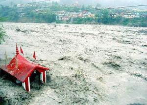

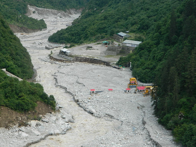

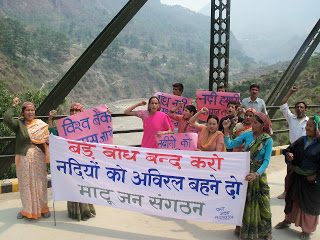


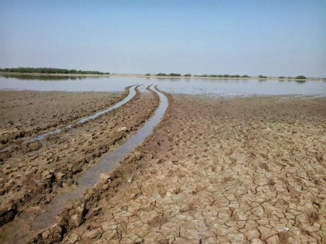

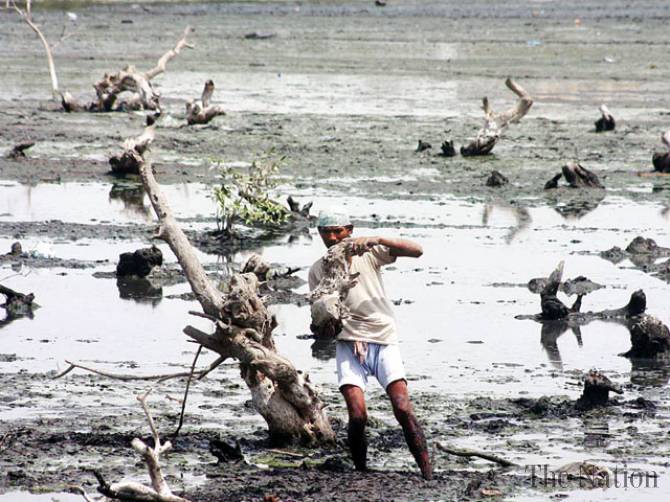


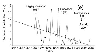
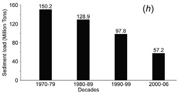
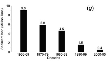
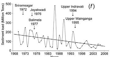

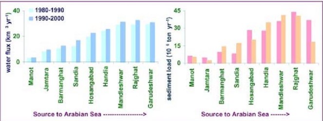
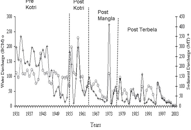
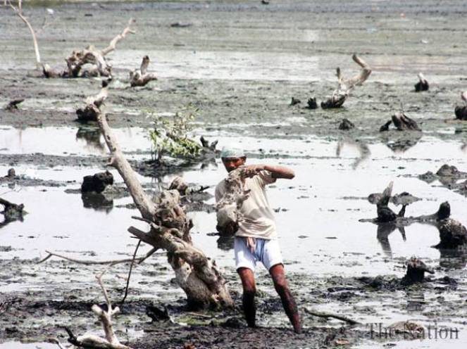
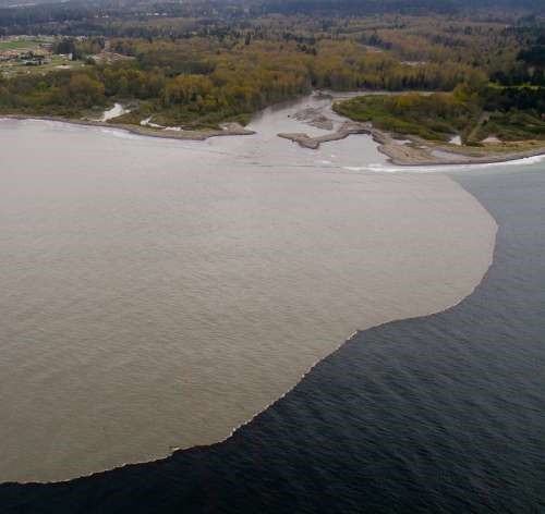
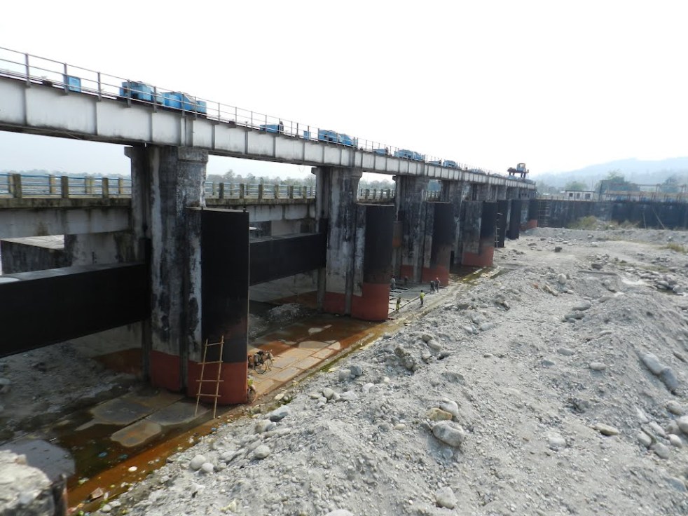
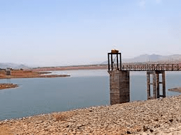


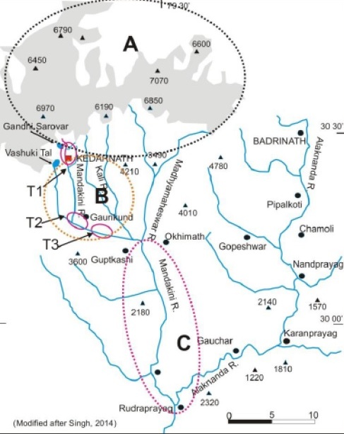




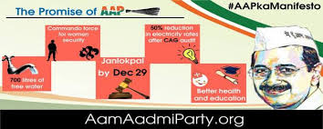
 One of the two lead coordinating authors of this report was Dr. Arun Kumar, from AHEC, IIT Roorkee. Notably, Dr. Kumar was also a part of the team which worked on Cumulative Impact Assessment of Hydropower projects in Upper Ganga basin of Uttarakhand