Middle Vaitarna Dam across the west flowing Vaitarna River near Mumbai is supposed to be a state-of-the-art technological feat. It’s a 102 meters tall concrete dam, the second tallest in Maharashtra. It was built with an what is claimed to be innovative mix of cement and fly ash from Eklahere Thermal Power Plant. The dam is also claimed to be completed in a record time. Additional Commissioner, Municipal Corporation of Greater Mumbai (MCGM), Mr. Jalota claims that Middle Vaitarna was completed in 15.5 months out of the total project duration of 42 months. This speed is supposed to be ninth fastest globally for RCC Dams[i].
Middle Vaitarna Project Photo with thanks from mmmhydropower.blogspot.com
The project was partly funded by the Jawarharlal Nehru National Urban Renewal Mission (JNNURM). When fully functional, the dam will be supplying 455 MLD (Million Liters per Day) water to MCGM (Municipal Corporation of Greater Mumbai), one of the biggest Municipal Corporations of the world.
So many exceptional performances claimed for one dam!
One would expect the similar concern for efficiency and speed while dealing with rehabilitation and resettlement of project affected population.
The project submerged over 3473 hectares of land (8581 acres land) including over 634 hectares forests (1566 acres forest). It also affected about 8 villages and several adivasi padas in the region. Of these, only 35 families who lost their homes were rehabilitated in a colony near the project site of Kochale village.
A visit to the rehabilitation colony in 2012 and in January 2014 where the project affected families moved in last year reveals:
Extremely poor construction quality. Just one year after families moved in, roofs of one of the houses collapsed. Human injury was narrowly avoided.
Resettlement Colony of the Middle Vaitarna Dam. Photo: Amit Tillu
Almost all of the homes are chronically leaking.
There is no drinking water supply to this colony. The main supply tank does not get water. So no taps are working.
Middle Vaitarna Colony Photo: Amit Tillu
There is no water in the toilets. Site-in-charge and contractor orders a tanker when they feel like.
Common electric connections are defunct: Contractor took away the meters. No electricity at Hospital, Temple and Community Hall.
No Doctor has been appointed at the hospital. It’s an empty building.
Middle Vaitarna resettlement colony Photo: Amit Tillu
Completely disillusioned by these houses, many affected people have built separate mud and thatch houses next to the ‘Sarkari’ homes.
Middle Vaitarna Resettlement Colony Photo: Amit Tillu
What is the state of other Project affected people?
The affected people from Kochale, Karegaon, Vihigaon have received paltry compensation sums at Rs. 28000 per hectare for cultivated land. This is much lower than per hectare compensation given to the Forest Department for trees lost.
Smt. Sangeeta Vare from Kochale village, struggling to get a project affected certificate Photo: Parineeta Dandekar
Project affected were told that one member from each affected family will get a government job. Land acquisition for Middle Vaitarna has been done under the article 52 A of the Maharashtra Land Acquisition Act, which includes provisions for ‘Urgent’ land acquisition. Special Land Acquisition officer promised that action will be taken about securing some jobs. After a long follow up, none of the project affected have received jobs. Requests for recommendations for temporary jobs at the dam site have also been denied.
Regarding “Project Affected” Certificate (Government Resolution 21 Jan 1980): According to the Maharashtra Project Affected Persons Rehabilitation Act 1999, it is the duty of the Collector “to issue a certificate to a person who is nominated by the project affected person for being employed against the quota reserved for the nominees of the affected persons”.
None of the PAs from Middle Vaitarna have received these Certificates, even after repeated and expensive follow up with a number of agencies.
When they contacted the Tahasildar, they were given a list of 12 documents that they have to compile in order to get this Certificate.
These documents include certificates from 4 other officials.
Considering the fact that all the Project affected persons of Middle Vaitarna Project are financially vulnerable tribals, with minimum education and considering that this small number of population is bearing the brunt of displacement and loss of livelihood for a mega city, they could have been helped with in this task.
In the case of Bhatsa Dam near Middle Vaitarna, the same conditions prevails for over 35 years. Project affected have not received full compensation, have not been given project affected certificates or any jobs.
The state of rehabilitation and resettlement for the claimed state of art dam seems dismal to say the least. More than 12 dams are coming up around Mumbai Metropolitan Region for drinking water supply. These will together affect more than one lakh tribals and over 7000 hectares of forest.
At a time when the creation of separate Telengana state from Andhra Pradesh is making headlines in the national media, the issue Polavaram dam seems to have been sidelined in media. But Polavaram dam holds huge significance in this situation since construction of this dam is one of the condition laid down by the center in order to create state of Telengana bifurcating the state of Andhra Pradesh. The dam though has no legally tenable clearance, Odisha and Chhattisgarh continue to oppose it and there are cases pending against the project in the Supreme Court.
Location map of Polavaram with the Submergence area
Now a 2013 film by social activist and filmmaker Saraswati Kavula “Dam’ned” documents plight of the people being affected by the Polavaram dam. The film also brings out the critical issues associated with the construction of this mega dam which were rarely covered by any media. The film is available in four parts on youtube, see: http://www.youtube.com/channel/UCb4JjIYab5w_dFkHwkmkrHQ?feature=g-user-u.
The 71 minutes film is a brilliant documentation of peoples sentiments associated with the river, land and a project which will submerge all of these. Within these 71 minutes the film brings to light the multitude and complexity of issues associated with this mega project. But before getting into that, a brief about this gigantic project has been provided, as given in the film.
The Polavaram Project Polavaram is one of the most controversial dam projects in India. It is also the largest dam in India in terms of the number of people it would displace. The dam will be located near Polavaram village in West Godavari district of Andhra Pradesh, an area bordering Chhattisgarh and Odisha. The dam aims to irrigate 7,21,000 acres of land in four districts of Andhra Pradesh i.e. West Godavari, East Godavari, Vishakhapatnam and Krishna districts. The project proponent claims that this project will also provide drinking water to 540 villages of Vishakhapatnam district along with the city of Vizag and to provide water to industries located in Vishakhapatnam district. The project also aims to transfer 80 TMC (Thousand Million Cubic Feet) water from Godavari to Krishna river basin.
The cost of mega plan will be majorly born by the ethnic tribal people of Andhra as well Chhattisgarh and Odisha. The dam will submerge 300 villages displacing 2,00,000 people. The submergence area will be so huge that the back waters of the dam go all upto Sabari river in Chattisgarh and Sileru river in Odisha. This submergence area will cover 10,000 acres of biodiversity rich forest and also partially submerge the Papikundulum wildlife sanctuary. The people living in these areas are predominantly ‘adivasis’ belonging to Koya and Konda Reddy tribes. There is a substantial number of no-tribal people, majority of the belonging to Dalits and backward classes. In numbers nearly 200 out of the 300 submerged villages are adivasi villages.
Why this Film is Important The film is threaded around people’s strong links with the land, forest, biodiversity and river. Throughout the film how people have associated themselves with the natural resources and how breaking this association is inviting havoc for the economic conditions and social relations have been depicted brilliantly.
“This is a land where our ancestors have been living for ages and we won’t leave it at any cost” such sentiments have been echoed throughout the history in most cases of displacement caused due to dams or any other project displacing people. This film on Polavaram documents with videos why and how this is such a crucial case against such projects. The film shows how displacing people from one place and giving them compensation either in terms of money or in rare cases some land has done little to improve the conditions of the people and has in fact impoverished and disempowered the people. This, as the film very clearly shows, has thrown them in to a life of poverty and uncertainty.
The film is packed with interviews of the people affected by the dam either due to submergence or due to other project components like canal construction. The filmmaker also interviewed experts from the field to show how the construction of Polavaram dam violates legal norms, is technically not feasible and takes no lesson from the experiences of construction of similar project in other parts of the country and how better options exist.
The personal interviews done brings to light how the people have little information about the project in Andhra Pradesh and have literally no information in Chhattisgarh and Odisha. In Andhra Pradesh, the government is also building infrastructure such as roads and buildings in areas which have been identified as submergence areas. This rather than helping people is creating confusions. There has been no environment or social impact assessment or public consultations in Chhattisgarh or Odisha, nor any plans for rehabilitation or environmental management. The Polavaram project got environment clearance in Oct 2005 but till 2013, in Andhra Pradesh out of the 276 submergence villages only 30 to 40 villages have been receiving compensation and that too only partly for their land only.
Complexities with Compensation: Monetary The film also brings out what is actually happening with the money given as compensation. The compensation that was given to one affected family, loosing 1.5 acres of land, was Rs. 1,68,000. When asked what did they do with the money, the head of the family said that they distributed the money among the family members where each person got around Rs. 10,000. People from Khammam district narrated the story of how they have been looted in the process of getting the compensation cheques from the government officials and lawyers. People were also cheated by insurance companies which came to these areas in large numbers posing as banks after people received their cheques. People also believed that after the project compensation was given the social relations in villages have deteriorated. One of the ladies from an affected family said “Many people died since the money came… drinking heavily and died… People are fighting among themselves since the money came.”
The Bone of Contention: Land The film shows that even in case of the compensation received in the form of land, why the result is equally distressful. In a rehabilitation colony in East Godavari district few males are to be found since they have migrated to the cities to find work. People said that there is no farmland for them to work nor there is any work under MGNREGA. In Kuruturu in West Godavari district, the conflict over land between tribal and non-tribal people have intensified since displaced people were given disputed land as part of their rehabilitation plan. Many people who were given such land returned to their original villages due to these conflicts. They now conclude: “we have decided that its better we die in the Godavari, rather then go over there.” Some of the affected people (e.g. in Kunta block in Dantewada district of Chhattisgarh) face double displacement. The people of this area were forced to shift to Salwa Judum camps due to the conflict between Maoist and Salwa Judum since 2005. But at a time when they were returning to their villages to resume their lives, they were told that they will again had to leave their villages as they will be submerged by the Polavaram dam.
Canals Completed without any work on the Dam The film also throws light on drawback of the construction plan of the Polavaram dam. The films shows that the construction work of the irrigation canals of the project is almost complete at a time when no progress has been made in the construction of the main dam. This project, as Himanshu Thakkar of SANDRP points out in the film, resembles the Rs 75,000 crore Maharastra irrigation scam where canals were constructed to fulfill the interests of the construction lobby without doing any work on the main dam. The massive Andhra Irrigation Scam is only beginning to surface, as pointed out in a recent CAG report[i].
Embankments as Huge as ‘China Walls’ The film shows that the proposal to construct embankments as huge as the ‘China wall’ on Sabari and Sileru rivers of Chhattisgarh and Odisha to prevent submergence of the areas in these states can only be possible on paper. The plan to construct embankment came as response to Orissa High Court order which said that Polavram project cannot submerge the areas of Odisha and Chhattisgarh. However, embankments were not a part of the original construction plan which received clearance from Environment Ministry. Nor has there been any environment or social impact assessment or feasibility study based on ground realities of the embankment proposal. There has also been no public consultations in these affected areas.
Experts say construction of such embankments would be a huge blunder of the Polavaram project. In the film Prof. T. Shivaji Rao of Center of Environment Studies in GITAM Univeristy, Vizag opined that with embankments there will be greater damage for Odisha and Chhattisgarh. Andhra Pradesh has also made a plan to put 16 lifts at different points on the embankments on Sabari and Sileru rivers to lift the water from the tributaries to the main river during flooding season. During rains these lifts are to lift and pump the water over the embankment walls and pour it in the river. This is doomed right from the beginning. The film shows this by bringing a detailed account of the experience of similar sluice gate scheme on the Godavari embankment in Bhadrachalam where it failed miserably. The sluices got closed up leading to waterlogging and inundation of houses.
There is no doubt that this film is a very detailed documentation of the issues related with Polavaram dam. The filmmaker could have added some voices from the government or project authorities to give a complete picture. In the film serious concerns were raised against how the government has handled the whole issue of Polavaram. I would recommend all concerned must watch this film. For a copy, either see the youtube link given above or write to the film maker: skavula09@gmail.com, the price of a copy of the film is Rs 350/- including postage charges of Rs 50/-. Do watch and spread the word!
The December 2013 – January 2014 edition of SANDRP’s magazine ‘Dams, River and People’ is now available online. This is the 11-12th issue of magazine in its 11th volume. The contents magazine are mentioned in the list below. Packed with information on water, rivers, dams and environment, this issue covers matters at home in India as well in Bhutan, Nepal, Spain, Vietnam, United States of America and water dispute between India and Pakistan. The magazine in pdf format is available here — https://sandrp.in/DRP_Dec_2013_Jan_2014.pdf. Several of the articles are also available in SANDRP’s blog and they can be viewed just by clicking on the name in the list. Enjoy reading.
By Malika Virdi and Emmanuel Theophilus, Himal Prakriti
While hydro-power is projected as clean energy, there is sufficient evidence to the contrary, on various counts. One of the major concerns about hydropower projects, is that the dams, whether they be impoundment dams or diversion dams (the latter going under the misleading euphemism nowadays of run-of-the-river structures), critically fragment a river. Regulation and release of water at extreme lows (often nil) and sudden releases apart, dams are an impassable barrier for migratory fish, progressively depleting populations past critical thresholds, eventually leaving rivers bereft of life. Dead rivers affect not only the freshwater aquatic realm, but also all terrestrial life dependent on rivers, including large human populations. The impacts are known to cascade down the entire river continuum down to the oceans. Not only does such river regulation have serious political implications in terms of equity and justice between proximate and faraway users, but far-reaching cultural repercussions as well.
Kurichhu HEP Photo: Druk Green
In the on-going discourse on the large-scale build-up of hydro-power projects in the Himalaya, which will soon be the most densely dammed region on earth, one encounters proposed part-solutions, often billed as mitigation measures. Ofcourse, every attempt at addressing the serious problems created by hydropower projects is desirable and welcome. However, which of these actually mitigate or provide solutions to the problems created by hydro-power projects, and which of them only serve to provide camouflage from public gaze, or a cover of legitimacy for mandatory approvals, does require to be looked at more closely.
We have been hearing for long about fish passes of various designs constructed on hydro-power dams in the US and in Europe, to allow the passage of many species of migratory fish, to travel to their breeding grounds in distant mountain rivers. None of the numerous hydro-power projects under construction in Uttarakhand have incorporated any provision for the passage of seasonal migratory fish, and this is puzzling. How are hydro-power projects cleared on environmental grounds and approved despite their disastrous impact on fish movement and subsequently on fish populations?
One instance of a proposed mitigation measure is what was proposed by WAPCOS for NTPC’s Rupsiabagar-Khasiabara HEP in the Gori river basin where we live. While the project has recently been denied Forest Clearance for diversion of forest land for the specific dam-site, it had earlier managed to secure overall Environmental Clearance on the basis of proposed mitigation measures, and is being cited here as a case in point. Addressing the problem of creating a barrier for movement of migratory fish, WAPCOS proposed an entire fish breeding-and-stocking programme. The proposal was for setting up facilities for producing seed of snow trout (Schizothorax richardsonii) at a cost of Rs. 16.05 million, for periodically stocking 3 cm long fingerlings with 100 fingerlings per km of river, for 10 km upstream and downstream of the dam structure, for 5 years. Serious money that could even sound like a serious effort. Only, anyone living close to the river knows that the proposed dam-site itself, let alone 10 km above it, is entirely uninhabited by any fish whatsoever. This was clearly a ‘mitigation measure’ proposed only to obtain environmental clearance. It is another matter that even WAPCOS’s species fish-list for the river was just a wish-list.
In the context of addressing the problem of fish-passage, we were informed of a fish-ladder constructed by the NHPC for the Kurichhu HEP in Mongar in Bhutan, so we undertook to visit and see the fish ladder design, and to speak to the hydro-power company to understand how effective it was. The Kurichhu is a medium sized Himalayan river in Eastern Bhutan, forming the upper main-stem of the Manas river which originates in Tibet. Access to it by road is long and circuitous, and after a year of trying to get away for long enough to visit, we finally reached there on the cloudy afternoon of 11th January 2014. Prior permission had been sought for the visit through contacts in India, and we were received and shown around with rare grace and courtesy by officials of DrukGreen, the company running the hydro-power project after handover to it by the NHPC of India. The sight of the ladder was thrilling, and we were even permitted take photos of the fish ladder.
Fish Ladder at Kurichhu HEP Photo : Authors
January is not the season for either upstream or downstream movement of fish in that zone, so we could not see fish movement in the ladder for ourselves. However, we gathered the following:
The dam is a 55 m high (from the foundation) concrete gravity dam located at an altitude of about 530 meters asl and is 285 meters across the beautiful, dark, blue-green Kurichhu river at Gyalpozhing. At full reservoir level 15.70 million m³ of water is impounded behind the dam. At the time of our visit, one of the four turbines was operational and there was a small release of water downstream of the dam. The fish ladder was in flow, releasing just 0.8 cumecs of water. The project authorities said that during such low-flows, this is the only flow from the dam, since there is no minimum flow required to be maintained by law in Bhutan. The ladder is a pool-and-weir type, with submerged orifices and centrally located notches. A pool and weir design is one of the oldest styles of fish ladders. It uses a series of small dams and pools of regular length to create a long, sloping channel for fish to travel around the obstruction, in this case the dam. The channel acts as a fixed lock to gradually step down the water level; and to head upstream, fish must either negotiate a slot, or jump over from box to box in the ladder.
The Kurichhu fish pass has a total of 98 baffles, each 1.5 m wide and 1.5 m deep, arranged at a distance of about 2.9 m. The total depth of each pool is 2 m. There are two exits (water entrances) to the fish pass, the lower exit placed 5 m lower than the other, to provide for flow at different draw-down levels. The vertical height between the water level of the ‘stilling basin’ (interesting name for a reservoir holding 15.7 million m³ of water) and the water entrance for fish from below the dam is 32 meters. To achieve this height, the fish-pass channel has to traverse a total distance of 320 m, leading to a slope of 1:10, and resulting in a drop in height per pool of 0.3-0.4 m. Quite impressive, except that the slot in the centre of each baffle does not exceed 25 cm in width. Clearly, no way for big fish, and Mahseer (Tor), the fish with the longest migration distance in this river, also happens to be the largest carp in the world.
We asked the project manager whether they know the fish ladder to be effective. He said that on a few occasions during the fish migration season, they had stopped the flow of water in the ladder and found some small fish in some of the drained pools. They did not know which species they were. We enquired whether there had been any systematic study of the efficacy of the fish ladder, in terms of comparing, with a baseline since commissioning the dam in 2002. Whether there was a change in species composition, or a significant change in upstream fish populations during this time? He replied that they had not.
Discussion: It is understandable that project authorities in Bhutan were not familiar with names of fish species or other particularities, because people in Bhutan in general do not catch or eat fish. This could stem from Buddhist tradition, but also from funereal custom, where one of the traditional options is that the body of deceased adults is dismembered and consigned to the river for fish to consume.
On enquiring about any documentation with regard to the fish ladder design, they kindly shared a document titled ‘Feasibility Studies for fisheries development in Kurichhu reservoir, Bhutan’ prepared for NHPC, Faridabad, by CIFRI, Calcutta. While CIFRI has been hired by NHPC ostensibly for extending their expertise on fish, they could have spared us their use of tired narratives of ‘development’. It is clearly beyond their area of expertise. Prefacing their feasibility study on fish passes with statements such as “advancement of human civilization and distortion of natural habitat go hand in hand,” and “requirement of electricity is synonymous with the development of civilization”, and more, just exposes their fait accompli. We photographed relevant pages onsite, and along with discussions, have gathered the following:
Since every fish passage requires to be designed to cater to the specific behavioural propensities and physical capabilities of a particular set of fish species inhabiting the river in question, certain stretches of the river were sampled by CIFRI. The fish they caught can be grouped into three broad groups:
Snow trout, mahseers and minor carps: Schizothorax richardsonii. S. Progastus, Barbodes hexagonolepis, Labeo dolycheilus.
Loaches: Garra lyssorhinchus, G. gotyla,
Catfish: Glyptothorax coheni, G. brevipinnis, Pseudocheneis sulcatus.
CIFRI did not catch Tor during sampling, but during dam building many fish were caught by workers and staff from India, one 15 kg and another 20 kg fish near Kurizhampa bridge. Fish of this size cannot be Barbodes or Chocolate Mahseer, and seem to be Mahseer of the Tor genus (species tor or putitora).
The three functional categories of fish migration in general are: Reproductive (spawning) migration, feeding (trophic) migration and refuge migration. For this, hill-stream fish are known to migrate between three major habitats: A wintering habitat, a feeding habitat and their spawning habitat.
Dams and other diversions for river regulation are seen to impact fish in five major ways:
Obstruction in the ascent of fish in their migration for spawning.
Reservoirs can inundate spawning habitat, silting up gravels,
Changes in river water quality due to inter-basin transfers and stratification of water.
Natural flows downstream are radically altered. This includes abruptness of changes in flow, in volume, velocity and seasonality.
Prevention of young migratory fish and refuge migrants from descending to lower reaches.
In addition, adverse repercussions result from indirect effects such as the disruption of the food-webs downstream, stranding of fish during rapid flow fluctuations, and siltation in the reservoir above the dam. The chemical, trophic and thermal properties of a river are greatly altered. Additionally, changes in slope, riverbed profile, structure of the bottom surface, submergence of gravel zones, and changes in the thermal and trophic regimes, affect the habitability of certain stretches of the river.
Designs of fish passages are many, and can be broadly categorized as follows:
Fish ladders. Pool and weir, baffle fishways, rock-ramp fishways, vertical slot.
Fish lift locks
Fish elevators
Fish trapping and hauling.
Pool and Weir Type Fish Ladder, Bonneville Dam, United States Photo: WikipediaSpecial Fish Ladder for Salmon in Sweden. Photo: Wikipedia
The basic information you need for designing a fish pass, is details about the species particularities such as normal cruising speed and burst speed of target species. Some important criteria are:
Provision of comfortable passage for all migratory species, including the poorer swimmers, over the entire length of the fish pass. To achieve this, provision for refuge against fast currents at regular intervals should be made.
Year-round functionality, under different flow regimes, temperatures and oxygen levels, notably to enable fish displaced by floods to return to their initial habitat.
Sufficient space or carrying capacity allowing massive upstream ascents during reproductive or trophic migration.
Positioning the entry of the fish pass so that it is readily identifiable and accessible to the migrants.
Attraction of fish to the fish pass entrance in the downstream (water exit) in case of upstream migration and deterring them from dead-ends and dangerous places.
Positioning of upstream outlet (fish exit) of fish passes far enough from spillways and turbines to minimize the risk of being swept downstream or being damaged.
Clearly, creating an artificial fish passage is complex and would not work if the multiple aspects are not considered and provided for. Ease of physical passage is just one important aspect. Migration is specifically timed to match various conditions, and even a delay in migration can nullify the purpose. For example, upwelling and excessive turbulence in the areas near the fish entrance are undesirable, as they can confuse migrating fish from finding the entrance. For this, the gates of the dam are required to be manipulated so that the heaviest spill is at the bank opposite the fish-way, with the result that the velocity barrier forms a diagonal lead, a traffic signal of sorts, across the river to the fish entrance. Apart from a sufficient ‘attraction flow’ at the entrance of a fish pass, projects elsewhere have experimented with directing fish traffic with the help of guiding screens, and the use of overblown ‘traffic signals’ such as acoustic arrays, strobe and mercury lights, and even electric fields.
At a fish passage such as the array at Kurichhu, it is critical that at the entrance of the fish-way, the gate is to be manipulated to ensure possible passage of fish. Depth and velocity to suit particular species need to be maintained. CIFRI recommended a ‘compromised’ depth of 25 cm to be sufficient to allow fish passage. In addition the gates should be regulated to ensure that all the baffles are submerged, allowing the fish to swim over them upstream comfortably. This was not the case, when we visited, the flow level did not allow for the baffles to be submerged, as visible in the photograph as well.
Even with a depth of 25 cm in the fish exit, the variable head-height as per the draw-down of the reservoir can create a higher velocity than desired. While CIFRI warns that this poses apprehensions regarding hindrance to fish migration, they dismiss these apprehensions summarily thereafter, stating that this high velocity is observed only for a short distance, which fish would be able to negotiate using burst speed (high speed, short duration). CIFRI mentions that it is only when the speed at the water entrance or any other point exceeds burst speed, (5-6 m per second) that fish would be unable to cross this speed barrier.
While variables such as water temperature and fish length are determinants of swimming speed of fish, CIFRI has assumed that Schizothorax and Barbodes can swim at 3-5 and 2-4 m per second respectively. They have taken the flow speed of water with head height, and fitted it to the equation for determining the velocity through the orifices in or over the baffles, and they are estimated to be ranging from 2.69 to 2.80 m per second, which they say, ‘permits the fish to cruise through the fish-way comfortably.’
There are some doubts here. Even a short distance of one baffle, or at just the entrance is critical, because if that is unpassable, the entire fish-way is unsuccessful. Further, CIFRI has arrived at burst-speed of fish for this river not by actual studies on specific species, but by inference from studies on fish in other countries. What strikes as doubtful about this basis, is their assumption that all other things being equal, a fish of any species is capable of equal burst speed, provided it is of the same length. This does not match anything one sees as evidence in the occupation of different fish species in different river stretches, nor in their striking speed while feeding competitively.
In order to test whether the fish ladder was ‘working’, CIFRI officials operated the fish pass in March (the beginning of the migration season) for 3 days and then closed the sluice gates to check. They found Schizothorax richardsonii, Garra gotyla and G. lissorhinchus in the top-most pool. They did it again in June and found 8 species in the uppermost pool. While it is clear from this that some fish are making it up the channel right upto the top pool, they have no way of knowing for sure whether they were getting through the 25 cm gap at different draw-down levels.
The critical question here is not just whether some fish are making it up the channel, but which species, how many, and are breeding populations making it up on time? A relevant study cited on the April 2013 issue of the Yale Environment 360,titled ‘Fish and hydropower on the U.S. Atlantic coast: failed fisheries policies from half-way technologies’ by J.Jed Brown and 6 other co-authors (Conservation Letters, Vol 6. Issue 4, p 280-286, July/Aug 2013) is instructive. The discussion by co-author John Waldman is titled ‘Blocked Migration: Fish Ladders on US dams are not effective’, citing this study goes on to say that fishways on rivers in the U.S. Northeast are failing, with less than 3 percent of one key species making it upriver to their spawning grounds.
Waldman says that “in most major rivers in the U.S., maintaining some semblance of the integrity of migratory fish runs past hydropower dams is dependent upon the fish using ladders and elevators”. They undertook a study of the success – or, rather, failure – of Atlantic salmon, American shad, river herring, and other species in migrating from the sea to their spawning grounds past a gauntlet of dams on three rivers in the northeastern U.S. – the Susquehanna, Connecticut, and Merrimack. Waldman says “what we found was grimmer than we expected. For one species, American shad, less than 3 percent of the fish made it past all the dams in these rivers to their historical spawning reaches. The sobering aspect of these contemporary studies is that they are based on the insubstantial number of fish today as compared to earlier massive migrations of these species, which numbered in the many millions. For the international community, the record of fish passage on rivers in the northeastern U.S. is a cautionary tale”.
He goes on to say that “hydropower has often been billed as a clean source of renewable energy, and generating electricity without polluting the air or producing greenhouse gases is commendable. But ‘clean’ is in the eye of the beholder, and any claims to being sustainable ignore its multifarious aquatic effects, including blocking fish passage, fragmenting habitat, and undermining a river’s fundamental ecological services.”
What Brown and co-authors found was bleak. One metric used was the percentage of fish passing the first dam that also passed just the second dam. For shad, the numbers were 16 percent on the Merrimack, 4 percent on the Connecticut, and 32 percent on the Susquehanna. But on these rivers, Waldman says, the second dam is only the beginning of the journey, and these rivers have multiple dams blocking access to historical spawning reaches. It’s important to put these results in perspective because they are merely relative to the present paltry numbers of fish that even attempt to migrate up these rivers.
The study says that there are three absolute numbers that matter. One is how many ran annually before the dam was created, the second is the numbers targeted for restoration in fish passage programs, and the third are the numbers that actually show up each year. On all the rivers examined by the study, restoration goals were in the hundreds of thousands of fish – at least one, if not two, orders of magnitude less than historic, pristine runs. Yet run sizes obtained across three decades ranged annually from a high of about 10 percent to, more commonly, 2 percent or less of the stated goals.
There are two significant aspects worth taking note of here. First, the three absolute numbers that matter, as mentioned in the paragraph above. The construction of a fish ladder must come with quantified stated goals, in terms of the number of fish that are required to pass as minimum, to achieve the desired stability of fish populations. This requires an estimate of populations prior to building the dam, and an estimate of the number that migrate unimpeded, as well as specific population dynamics. Fish migrations in large rivers can be in the millions, as already cited here from Brown and Waldman’s study. Here at the Kurichhu, or any other fish-pass in India, population and migration estimates, let alone quantified goals are a far cry.
Secondly, the study clearly illustrates that every subsequent dam upstream has a cumulative impact on the numbers of fish succeeding upstream, diminishing in orders of magnitude. This brings to the fore the critical importance of considering cumulative impact of multiple projects, despite ‘mitigation measures’, along an entire stream-length, before any clearance is given piece-meal.
While on the design for fish-passes on specific hydro-projects, there are many aspects other than physical passability provided by a fish-pass, that determine its success or failure. Changed flow, turbulence, and volumes can be disorienting for fish leading to serial delays, making it unlikely that the many fish make it to the spawning reaches at the optimal time in the river’s seasonal ecological cycle. The numbers of adults successfully returning downstream past the dams also sacrifice their future spawning potential. The flow out of an operating fish-ladder is often very small compared to the water going into the intake to the turbines, and fish will often choose the larger flow during descent, to their peril. At Kurichhu for example, the flow down the fish ladder is just 0.80 m³ a second, which is a fraction of the flows for the 4.75 m diameter intake of any one of the four 15 MW turbines.
There is also the larger question of flows in a river being regulated by series of dams, and sometimes being too low to provide the necessary cues for hormonal change and migration, puts paid to fish even reaching fish-ladders in the first place.
The study by Brown and colleagues in the US says that despite vast spending on modern technologies, contemporary shad migrations on these rivers are at least three to four orders of magnitude below the original unfettered run sizes, with similar results for salmon and river herring. While dams alone don’t explain these results; overfishing, habitat destruction, and alien species contribute – but there is widespread consensus among fish biologists that dams (such fish-passes notwithstanding) are a primary cause. Surely, a cautionary tale for India.
And here is another cautionary tale for India, where unlike Bhutan, fish are eaten, readily. Thirty-three years ago, standing on the Sutlej Barrage at Ropar in Punjab, I witnessed a strange sight. At the base of the barrage, there was some urgent movement in the cold blue waters of the Sutlej in early spring. Mahseer fish were attempting to migrate up and beyond the 10 meter high barrage. There, right along the buttress of the sloping spillway, one could see a living pyramid of thousands of fish upon fish, slithering up the side of the uni-dimensional triangle against the spillway, barely submerged in the leaking flow from one of the gates, and wriggling on top of and past each other, in a futile effort to make it over the barrage. While this may just have been a collective shoal strategy to get past smaller rapids, it was a death-trap for fish there, against a steep and high barrage. Some other men had already seen this, and I could see them wade up to the desperate and tenuous pyramid in knee deep water below the barrage, and carrying away fish in sack-loads.
Hydro-power projects in India may undertake to construct fish-ladders projected as mitigations measures to obtain environmental clearance, but that does not prevent the staff and others from making the best of the concentration of fish at the base of the fish-ladders and even at un-passable barrages and predating on them. The CIFRI study for the Kurichhu mentions that Indian workers hired by NHPC regularly fished at points of concentration during migration season, nullifying the purpose of the fish-pass. Clearly, the dam authorities will also need to be charged with the responsibility for protection of fish-passes, and other points of concentration even on dams without fish passes.
These are some of the aspects that require to be further investigated about fish-passes in our Indian context, and to be put on the table for discussion and closer scrutiny when mitigation measures are proposed by hydro-power projects.
Editor’s Note from SANDRP:
When the rivers in Himalayas are facing huge impacts of cascade hydropower projects, it is important to look at the role played by organisations like CIFRI ( Central Inland Fisheries Research Institute) which is supposed to be Asia’s “premier facility in the feild of inland fisheries research” CIFRI was hired as a consultant for recommending eflows for Teesta IV HEP in Sikkim and 780 MW Nyamjangchu HEP in Tawang, Arunachal Pradesh. In the case of Nyamjangchu, CIFRI recommended a flow of 3.5 cumces from the proposed barrage point, which is 14% lower than the lowest flows recorded (extrapolated) for that site. It is highly improbable that even CIFRI’s target species of snow trout will be able to sustain these drastic flow reductions. CIFRI has not raised a voice when multiple dams are being planned without fish ladders or realistic mitigation measures across the country when protecting riverine fish and fisheries is a part of its mandate.
In a strange contradiction, although India’s NHPC has built Kurichhu HEP and CIFRI has designed the fish ladder for a dam that is 55 mts high, the EAC of the MoEF in India unilaterally thinks that fish ladders do not work for dams, even as high as 42 meters, This EAC also includes representative from CIFRI.
Before concluding that fish ladders will or will not work in India, we need extensive studies on this subject for different rivers and projects. Unfortunately, none are being undertaken, in line with our overall apathy towards riverine fish diversity and fisheries. Good, scientific studies will help in designing ladders which can be useful for species specifically found in Indian rivers, or will conclude that ladders will not work in specific cases, in which case, the irreversible impact of the project will have to be looked at in a perspective beyond ‘mitigation measures’.
The foundation stone of 3000 MW Dibang Multipurpose Dam was laid on 31st January 2008, by Prime Minister Manmohan Singh. Six years have passed since then but the project is yet to get the necessary forest and environment clearances. This in a way reflects the state of environment governance in India where the foundation stone of mega dam is laid without getting any necessary clearance.
This project was considered for forest clearance in the FAC meeting held on July 11th and 12th 2013. The FAC meeting minutes noted “Felling of more than 3.5 lakh trees most likely to have adverse impact on general eco-system of the area, recovery of which may be very difficult through any type of mitigate measures”.
The Expert Appraisal Committee (EAC) on River valley and Hydroelectric projects considered Dibang multipurpose project in its 68th meeting on September 23rd 2013 for environment clearance but this was in complete violation of norms. Following the “Lafarge vs Union of India and others” case of 2011, the Supreme Court of India had said that a project without forest clearance cannot be considered for environment clearance. SANDRP had pointed this out in our submission to EAC dated 20/09/2013. But EAC seemed to take no account of that.
Out of the 168 projects proposed for Arunachal Pradesh, this is the only multipurpose project. The minutes of 68th EAC meeting states that this project has dual objectives. The primary objective is flood moderation while electricity generation is its secondary objective. This is highly doubtful though since the project does not have the adequate storage capacity. On the other hand, the installed capacity of the project i.e. 3000 MW is also one of the highest among 168 hydropower projects.
The Dibang multipurpose dam is located 1.5 km upstream of confluence of Ashu Pani with Dibang river at Munli village in Lower Dibang Valley district. Construction of this dam involves two districts of Arunachal Pradesh viz. Lower Dibang Valley and Dibang Valley districts. All the project components e.g. dam, power house will be are located in Lower Dibang Valley District while reservoir which will submerge 43 km length of the river will fall in both districts. The total land requirement for this dam is 5794.142 ha out of the 5022.842 is forest area with very rich bio-diversity. Submergence of such a huge forest is one of the major concerns associated with this dam and that is why the Forest Advisory Committee (FAC) has refused forest clearance to this project.
The Dibang multipurpose project plans to construct 288 meter high concrete gravity dam with an underground dam toe power house. The reservoir of this project will submerge 40.09 sq km area. The total cost of the project at November 2007 price level was estimated at 15886.39 crores.
It is important to note that the public hearing for the project faced vehement opposition of the local people. The public hearing of the project has been halted for several times. The local people expressed serious concern regarding Dibang multipurpose project and feared that influx of outsiders for dam building will lead to a demographic imbalance in the Dibang valley. This is a serious issue since the primary inhabitants of Dibang valley are Mishmi (Idu) which is a very small community with a population of 11,023 according to 2001 census. According to NHPC estimation a workforce of 5800 people (labour and technical staff) would be needed for the Dibang multipurpose project. But All Idu Mishmi Students Union (AIMSU) has contested this figure and opined that a single project would bring about 15,000 people into the region. It is also reported that NHPC claim that the project will cause ‘negligible human displacement’ grossly undermines its harmful impacts on smaller ethnic community such as Idu Mishmis. A video of the protest by local people can be seen here – http://www.youtube.com/watch?v=m8TCUKh2hQY
No cumulative impact assessment of dams in Dibang valley has been conducted e even though 17 projects have been proposed for this region. The TOR clearance had been given to 86 MW Ithum and 3097MW Etalin HEP in the basin by EAC. Without any cumulative impact assessment study of the basin no project should be given environment clearance. People from Dibang valley has also written to previous EAC on demanding cumulative impact assessment study. A letter to EAC from a local person Raju Mimi, dated January 31st 2013 stated “Since the 3097 MW Etalin project is on agenda again for the 64th EAC meeting to be held on Feb 1st – 2nd 2013, we re-iterate our demand to have prior cumulative impact assessment of multiple hydropower projects by urgently commissioning a Dibang river basin study.”
Other Glaring Issues of Dibang Multipurpose Along with the above mentioned issues SANDRP had made detailed submission to EAC pointing to some of the glaring concerns associated with the project. Some of these issues are –
Incomplete and Shoddy Downstream Impact Assessment: The downstream impact assessment done for the Dibang multipurpose does not take into account impacts of the dam in Assam. The downstream impact assessment study does no assessment beyond Dibru-Saikhowa and whatever has been done is also very much inadequate.
No Public Hearing Held in Assam: Even though the Dibang multipurpose will have severe impacts in downstream Assam, there was no public hearing held for the project in Assam.
Mining for the Dibang Multipurpose will lead to Catastrophes: Mining of boulder, sand and other construction material for the Dibang multipurpose project will have very severe impacts on the river as well as on the local environment. The amount of boulder required for the construction of this project is 193 lakh cubic meter as stated in the project document. This is really astonishing figure and impact of such mining on the river bed and nearby areas will be catastrophic. The fragility of the Himalayan mountain range is not unknown to anyone and mining in such a sensitive hilly area will area will only increase the risk of landslide and disaster. The catastrophe of Uttarakhand floods is a clear example of this.
No Climate Change Assessment Impact of climate change on the project and impact of the project on the local climate. No attempt has been made to assess the impact of green house gas emissions from the reservoir of the dam which extends to 43 km.
No assessment impacts of peaking power operations Impacts Detail assessment of impacts of peaking power operation during non-monsoon months not done. Impacts on the flow characters of the river due to this dam, what will be the changes and how these will impact downstream areas.
No Assessment of Disaster Potential Impact of the project on disaster potential in the project area as well in the downstream including Assam due to construction and also operation at various stages, say on landslides, flash floods, etc.
No Assessment of SiltFlushing Impact of changing silt flows downstream from desilting chamber and from silt flushing in monsoon on the downstream areas not analyzed. A detail account of how the silt from the dam would be flushed out annually and what would be the impact of this in the downstream as well as on the geo morphology, erosion, stability of structures etc was not done.
What did the EAC say in 68th Meeting The EAC in its 68th meeting did not recommend environment clearance to the project and instead pointed out several issues in the EIA – EMP report. Some of the important issue pointed out by EAC are –
1. Attempts may be made to avoid submergence of huge area of rich forest land. It merits mention that due to the very high forest land submergence, forest clearance has not yet been accorded by FAC.
2. Environmental Flow in the diverted portion of about 1.2 km i.e. between dam and TWL of dam toe PH is to be reassessed and a suitable quantity is to be proposed for release as per extant norms. 4% flow as suggested was found to be inadequate.
3. Numbers of Fish species reported was found to be on lower side and NHPC was asked to verify this and report accurately.
4. Number of plant species reported also appeared to be on lower side and to be rechecked by NHPC.
5.At this altitude of the project (about 3000m), snow leopard should have been sighted. It may be erroneous to report that leopard was not found in the study area. Therefore, this may be relooked.
6. Study area in back water/ submergence is also to be extended for proper inventory of both flora, fauna/bio-diversity.
The impacts of the Dibang multipurpose project are going to severe on the river, people and overall ecology of Dibang river basin. But sad part is that no proper assessment of these impacts has been done till now. Looking back at the six years since the laying foundation stone for the project we reiterate what Forest Advisory Committee said about the project “ecological, environmental and social costs of diversion of such a vast tract of forest land, which is a major source of livelihood of the tribal population of the State, will far outweigh the benefits likely to accrue from the project.”
Subject: Issues about the laying of Yettinahole Diversion Project’s foundation Stone
Respected Dr. Moily,
We learnt about your announcement and support for laying the foundation stone of the controversial Yettinahole Diversion Project on January 31, 2014 in your parliamentary constituency of Chikkaballapur, from several media reports[i]. The project has not conducted any impact assessment study and does not have any statutory clearance from your ministry. This is in complete violation of several norms and laws and is shocking, to say the least.
Dr. Moily, our assessments based on local interactions, site visits, study of the Project report (the DPR for the project is still not ready) indicate that the project involves eightdams inside the Western Ghats, deforestation of more than 100 ha of forests inside the Western Ghats eco-sensitive region, water diversion without any ecological studies, 370 MW of power for pumping, a canal of 250 kms length, 1200 ha submergence near Devaranyadurga including submergence of 2 villages and 600 ha forest land. [ii]
The foundation stone laying ceremony is supposed to take place on the 31st January 2014 at Muddenahalli, Chikkaballapur, which also happens to be your current constituency. It is clear why you chose Chikkaballapur to lay the foundation stone, and not Sakaleshpur, from where the water will be diverted, or Dakshin Kannada, which will face most of the impacts of the project. In Sakaleshpur and entire Dakshin Kannada, (which was your constituency in the past) there is a huge and mounting opposition to Yettinahole Diversion and also to your decision.
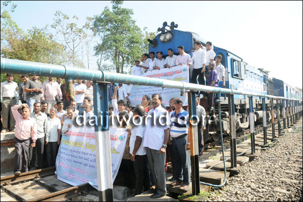
Just in the last two weeks, there have been attempts to a stop train in protest, numerous dharnas, hunger strikes, letters in opposition and a Satyagraha in Netravathi River to oppose this project.[iii]
Rail Roko protest against Yettinahole Diversion Photo: Daiji World
Despite this growing discontent, you, as an MP from Chikkaballapur and the Union Environment Minister, or the Karnataka Government did not feel the need to initiate a dialogue with the people of this region. Has the government learnt no lessons from Delhi as to what happens when local voices are ignored and unheeded?
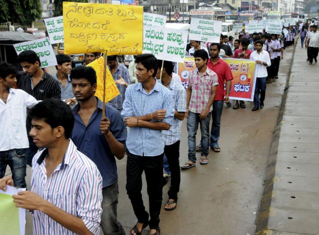
Protest in Hassan (in addition to Dakshin Kannada) against Yettinahole Diversion. Photo: The Hindu
Why has the Karnataka Government or the Union Ministry of Environment and Forests, which you now head, not thought it necessary to assess and address the serious ecological impacts of this project? Why have you supported the fraudulent tactics of this project to escape environmental clearance? Our letter to the Ministry in his regard dated 10 Sept 2013, which was endorsed by several experts remains unanswered till date[iv].
As the Minister of Environment and Forests, it is your duty to see that projects with significant impacts on ecology and dependent communities are assessed. Why are you escaping that duty?
Why is the Karnataka Government and the MoEF, under you leadership, hiding behind weak technical clauses of the EIA Notification 2006 to claim that the project does not qualify for Environment appraisal?
In fact the EIA Notification 2006 requires that there is thorough appraisal of the project. We have sent you a letter in this regard again on the 28th of January 2014, with scanned pages from the project report proving this.
How can you support foundation stone laying ceremony when RTI reveals that Forest Department has not even assessed the forest area affected by this project?
How can a Minister of Environment and Forests of India indulge in an illegal act of formal initiation of a project that does not have environmental or forest clearances?
The project will come to the Ministry of Environment and Forests, headed by you, for Forest Clearances. But you have supported the foundation stone for this project already, giving a signal that forest clearance is a foregone conclusion.
If this is not conflict of interest, what is?
And all this for 2.8 TMC drinking water for Kolar and Chikkaballpur Districts. Has the government conducted any studies to prove that project with Rs 100 Billion cost and severe environmental impacts is the least-cost option to get drinking water for Kolar and Chikkaballapur in whose name the project is being pushed?
Dr. Moily, as the Union Environment Minister, it is you duty to address these questions before you support the foundation stone laying of Yettinahole Diversion Project.
Not doing so is in violation of environmental norms and legal stipulations.
We are looking forward to getting a point-wise response from you.
Sincerely,
Parineeta Dandekar, Himanshu Thakkar, SANDRP, Pune and Delhi
Dr. T. V. Ramchandra, Energy and Wetlands Group, Centre for Ecological Sciences, Indian Institute of Science, Bangalore, Karnataka
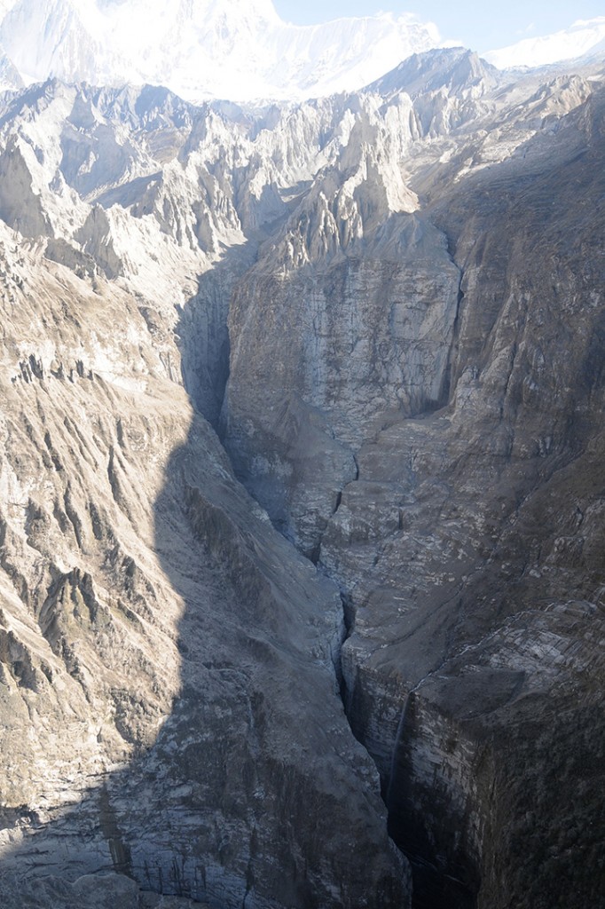
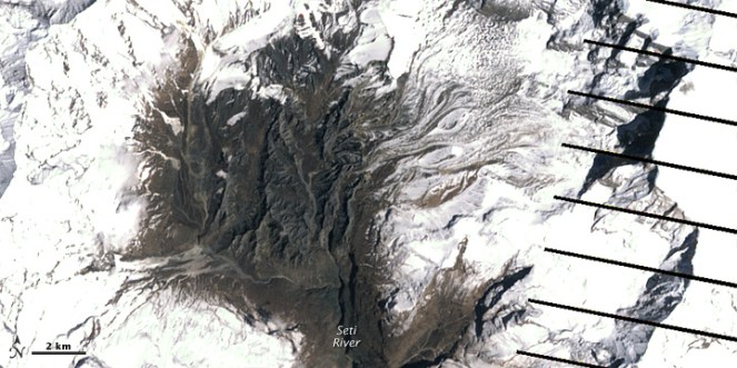
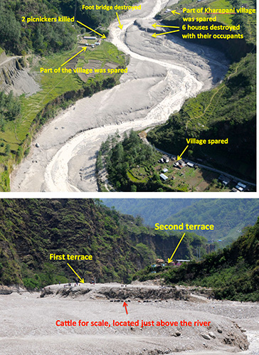
In late April and early May 2012, what was usually a roaring Seti river in Northwestern Nepal had slowed to a trickle. The milky-white turbid water had turned blue and clear. And then suddenly on May 5, 2012, the flooded river laden with slurry of sediment, rock, and water surged through the Seti valley in the Kaski district, obliterating dozens of homes and sweeping 72 people to their deaths. The floods waters were upto 30 m high at places. It reminded of the sequence of events leading to Tsunami. Questions swirled about where the water had come from and how it arrived with so little warning and that too in a non-monsoon season.
NASA Earth Observatory (acquired October 7, 2013)
The abstract of the paper by Shreekamal Dwivedi and Yojana Neupane of Department of Water Induced Disaster Prevention of Government of Nepal (presented in a conference in Nov 2012 and published in Nepal Geological Society (2013, Vol. 46)) provided some details of what happened in the floods: “Comparative Analysis of the Landsat ETM satellite images of 20th April, 2012 and 6th May, 2012 revealed that the area of about 32000 square meter of the southern ridge 1.5 kilometer away from the Annapurna IV peak failed in the north western direction. The impact of descending mass of the failed mountain from 6850 meters to 4500 meters almost vertically pulverized the ice, sediment and rock. The impact even triggered seismicity at 9:09.56 AM. local time which was recorded all over the 21 stations of National Seismological Centre. The closest seismic station at Dansing which is 32 km. south west from the area recorded the high signals for 70 minutes which corresponds to the duration of the debris flow. (The seismicity was equivalent to magnitude 3.8-4 in Richter Scale.) Lab analysis of the flood water sample revealed the density of the flow as 1.88 gm/cc. Analysis of the satellite based hourly rainfall GSMaP NRT from the period form 20th April -6th May 2012 revealed that there were just 4 occurrences of rainfall which amounted less than 1 mm/hour in the source area of the avalanche. The rainfall > 6mm/hour which occurred in the Kharapani area on 4 May was localized rainfall which did not extend to the avalanche area. Lack of systematic disaster preparedness caused huge loss of life and property even though the early warning message was received from the Ultralight pilot who was flying close to the area. The avalanche triggered high intensity floods which have similar characteristics to glacier lake outburst floods (GLOFs) have emerged as a new hazard in the Himalaya.”
Now, twenty months after the disaster, experts like Dr Jeffrey Kargel, hydrologist at University of Arizona, are in a position to throw more light what happened. Dr. Kargel has concluded that it was not just one event but a series of event that combined to produce the devastation.
NASA Earth Observatory site describes the affected landscape as: “The landscape in this part of Nepal is shaped by a cycle of landslides and subsequent erosion. As the tectonic collision of India with Asia pushes the Himalaya upward, ice, water, and gravity, assisted by sporadic earthquakes, combine to grind the mountains down. The channel of the SetiRiver itself is cut into the remnants of a much larger debris flow, perhaps 1,000 times as big. 60 to 100 meters (200–330 feet) thick, the landslide deposits are composed of the same limestone as the peaks to the north. Likewise, the May 2012 flow left behind jagged fragments of limestone, carried from the crest of the Himalaya to the foothills in a single event.”
‘Seti’ in local languages means white, and Seti is the ‘White River’, its water is glacial white, turbid and laden with sediment.
The high intensity floods in May 2012 came in waves, and the first wave alone had around a quarter of a million cubic meters of water in just a few minutes. There were about 27 waves in all over the next hours, according to eyewitnesses, so several million cubic meters of water flowed overall. As Dwivedi et al note, “The huge mass of debris along with ice chunks rushed down the river as a debris flow for 20 kilometres downstream at Kharapani in just 28 minutes (almost 12 meters/second). The flood arrived at Kharapani, where most of casualties occurred, at 9:38 AM and reached the dam of the Seti irrigation system at 10:35 AM… The high-water level at the dam weir at Pokhara was 2.15 meters. The discharge estimation based on the water mark revealed the peak as 935 m3/s (B. Poudel, personal communication). The eye-witnesses in Kharapani area reported huge ice blocks floating in the flood. They felt vibrating ground and heard very loud sound similar to flying of several helicopter together. The smell of the flood water was muddy… Kharapani was a popular spot for picnic and natural hot spring bath… Most of the causalities occurred in this area as the warning message from the Pokhara Airport tower could not reach this area”.
It is heart warming to see that many lives were saved, as Dwivedi et all write, “Capt. Alexander Maximov, the pilot of ultra-light plane of Avia Club Nepal in the morning of May 5 was in a regular sightseeing flight close to the Mountain Machhapuchhre. He noticed a huge dark cloud in the high-mountain depression (Fig. 9) and immediately turned back. He sent a message to the tower of Pokhara Airport. His quick understanding of the unusual event and timely response has saved hundreds of lives during the Seti flood of 5th May 2012. He informed the tower at 9:16 AM and the message was broadcasted through FM radio; police forces evacuated hundreds of people living and working in the bank of the Seti River. Some eye- witnesses in the field said that information about the flood was also received in Kharapani bazar by mobile calls from the people who saw the flooding in the upstream area. This message has helped many people to run to safety. However there was no organized approach of the warning dissemination in the ground.”
Video shot by Capt. Maximov from his aircraft, as the event was was happening:
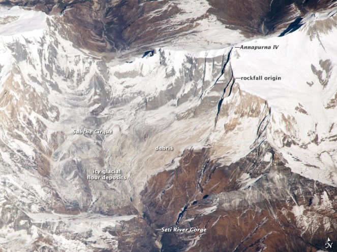
NASA Earth Observatory image (acquired Dec 22 2013)
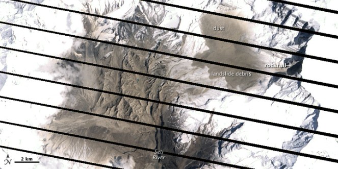
However, the series of event started weeks before the flood with a series of rockfalls that sent debris tumbling into the SetiRiver, backing water up in the extremely deep and narrow gorge. The last of these landslides occurred just a week or so before the flood. The situation grew dire on May 5, 2012, when an unusually powerful ice avalanche and rockfall tumbled down a vertical cliff on a ridge just south of Annapurna IV Mountain peak. The total drop from the Annapurna IV ridgeline to the bed of the Seti below Pokhara is about 6,100 meters (20,000 feet) spread over a distance of only 40 kilometers. The distance between the landslide dam and sight of worst floods was about 29 km.
Prof Jeffrey Kargel, writes (http://earthobservatory.nasa.gov/blogs/fromthefield/2014/01/24/setiriverclues/), “A flash flood—what geologists call a hyper concentrated slurry because it was thick with suspended silt—had torn through some villages along the Seti River, in north-central Nepal, just north of the country’s second largest city, Pokhara. It was immediately recognized as a very deadly event, but the death toll—and a tally of those who remain missing but were clearly also killed—was not known exactly for several months. 72 souls lost. Though not large on the scale of global disasters, this event was terrifying for the fact that it seemed to come from nowhere—literally from beneath a blue sky.”
AFTER IMAGE: shows the area on May 6, 2012, roughly 25 hours after the landslide
BEFORE IMAGE: the same area on April 20. The diagonal lines are gaps in the data, due to a partial failure of the satellite.
One scenario (see: http://earthobservatory.nasa.gov/IOTD/view.php?id=78070&eocn=image&eoci=related_image) estimates that roughly 22 million cubic meters of rock broke off the slope of Annapurna IV. Colin Stark at Lamont-Doherty Earth Observatory at ColumbiaUniversity said: “There’s a drop of about 2,000 meters into the canyon, so we’re talking an enormous gain in momentum. Then I think the debris ran down the canyon at speeds upwards of 30 meters per second—a guess but what we see for the landslide itself.” Stark estimated that events unfolded in a matter of minutes with no time for a temporary dam to form.
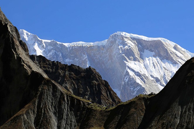
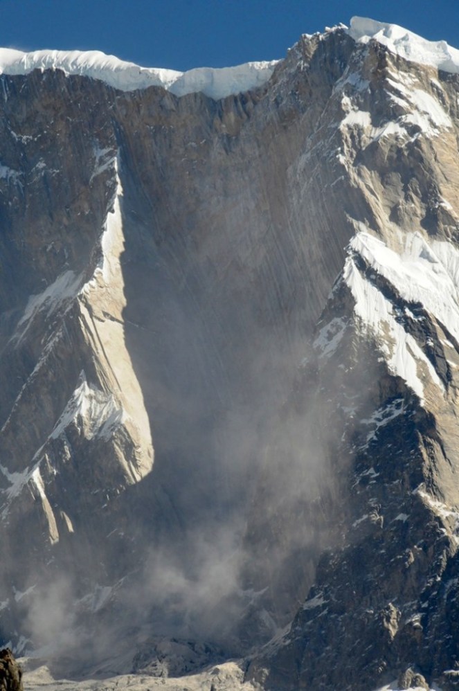
This flood appeared to behave like a glacier lake outburst flood, and the news media can be pardoned for having assumed that it was. Prof Kargel adds: “Seeing that the disaster occurred at the foot of the AnnapurnaRange, within the Greater Himalaya, probably every expert’s first thought was “glacial lake outburst flood” (GLOF), because these were common in Nepal’s Himalaya, and the news accounts of the disaster event resembled accounts of GLOFs”. However, available satellite images showed there were no such lakes. “It was, however, clearly a disaster that had its source in a high Himalayan amphitheatre-like bowl, a glacially-carved structure called the Sabche Cirque. This structure was rimmed by some of Nepal’s most famous, picturesque mountain peaks, including the storied, holy Machapuchare ( “fishtail” peak) & Annapurna IV, a 24,688 ft” mountain.
Annotated photo from Dr. Kargel
Thanks to video from winged camera of a 2 seater plane incidentally flying over the area at the time of the event, the disaster’s trigger was sourced on a ridgeline near Annapurna IV. Apparently part of this ridge—probably initially the glacier ice— collapsed, dropping ice and rock over 3000 m almost vertically onto unconsolidated rock debris (glacial moraines and ancient glacial lake silts and gravels) resting unstably in the deep bowl of the Sabche Cirque. Some of that loose debris was also swept up by the avalanche, and the mass flowed and dropped through an additional 1,500 m into the SetiRiver gorge. Indeed, the conversion of gravitational potential energy to heat could have melted roughly a tenth of the falling snow and ice by the time it reached the SetiRiver.
A view of the gorges and also the distant peaks of the Sabche Cirque and the ancient glacial deposits in between. The avalanche entered the gorge from the upper right corner of the scene. (Photo: Dr. Kargel)
One source seemed to be definitely involved, and that was a rockslide-dammed reservoir in the gorge. This was definitely not a GLOF, but was caused by a rockslide into the SetiRiver gorge, formation of an impoundment reservoir over a several week period due to damming of spring snow and ice melt, and then the final triggering event of the mighty rock and ice avalanche off Annapurna IV.
The source area for the avalanche of May 5, 2012. Annapurna IV is just off image to the upper left. (Photo: Dr. Kargel)
Warning: More such events could occur As Dwivedi et al have noted, “The southern slopes of Annapurna range have been experiencing avalanche-triggered high intensity floods also in the past. On August 15, 2003, the Madi River had experienced an unprecedented flash flood which destroyed the recently built rural road and triggered many landslides along its course and killed 5 people”.
“There are good reasons to be concerned,” Jeffrey says, “Something like this will happen again. It’s inevitable.” The Seti River Gorge is unusually prone to dangerous blockages because of how narrow and deep it is. And the same processes that triggered the spring 2012 rockfalls and avalanche are still at work. “The only question is whether future events will be as destructive or whether people in the SetiRiverValley will have absorbed the lessons of 2012 and found ways to move their homes out of the flood plain.” India should not forget that we are downstream country in Seti basin and what happens there will flow down here too.
In an earlier excellent paper on this event, Jorg Hanisch et al recommends that this event requires deep investigations and “Marsyangdi Khola, Madi Khola, Modi Khola and Kali Gandaki, all with apparent origin in the high-mountain environment of Annapurna Range (Hormann 1974; Yamanaka and Iwata 1982) should be included in the investigations… A new catastrophe of similar size would have an apocalyptic impact: about half a million people live in the valley today. A detailed investigation of the circumstances of the disaster on May 5th, especially the possible influence of global warming on the trigger of the disaster, and a reliable forecast of a potential recurrence of similar events or of even much greater scope, are urgently required. For this, the thorough understanding of the conditions, triggers and mechanisms of the huge flows in the past to compare it with the recent flood is indispensable as well.”
The proposal for a 140 MW Tanahu Seti storage project downstream of this flood event & supported by the Asian Development Bank, Japan International Cooperation Agency, European Investment Bank and Abu Dhabi Fund is questionable, says Ratan Bhandari of Nepal. Considering that the Seti River Basin is prone to such events in future, the proposal seems disastrous.
More significantly, this whole episode raises the question as to how much do we really know about the Himalayas. Uttarakhand disaster of June 2013 was a wake up call to understand the Himalayan ecosystem and its implications for future well being of the people and environment of India. However, in stead of learning any lessons, our governments in Uttarakhand (as also in Himachal Pradesh, Kashmir and North East) and at the Centre, with environmentally-challenged Mr Veerappa Moily as the environment minister, are playing into the hands of short sighted vested interests. This is also apparent in the recent decision to sanction the massive Lakhwar dam on YamunaRiver in Uttarakhand without so much as an Environmental Impact Assessment!
We still do not have full explanation for the Uttarakhand disaster of June 2013. This explanation of the Seti River Disaster in the same Himalayas, which happened just a year before the Uttarakhand disaster highlights the urgent need for more serious studies and applying precautionary principle while dealing with the Himalayas, its rivers and flood plains.
2. http://earthobservatory.nasa.gov/blogs/fromthefield/2014/01/24/setiriverclues/ This entry was posted on Friday, January 24th, 2014 at 10:34 am. See the absolutely amazing photos on the site that gives an insight into the situation in the head reaches of Seti River… possibly indicates how little we know about the catchments of our Himalayan Rivers.
7. “Cause and mechanism of the Seti River flood, 5th May 2012, western Nepal” by Shreekamal Dwivedi and Yojana Neupane, Department of Water Induced Disaster Prevention, Pulchwok, Lalitpur, Nepal (shreekamal @gmail.com), published in Journal of Nepal Geological Society, 2013, Vol. 46, pp. 11-18
8. Famous movie clip of the area, http://www.youtube.com/watch?v=Uk82ggshSKs&feature=related you can see landslide in the clip at 56-57 seconds of the movie. At this time the avalanche had not occurred yet. After taking one round the aircraft pilot has noticed the dark grey brown cloud formed by the avalanche (see the movie at 2 minute 7 seconds). This is thanks to Shreekamal Dwivedi
9. “The Pokhara May 5th fl ood disaster: A last warning sign sent by nature?” by Jörg Hanisch, Achyuata Koirala and Netra P. Bhandary, Journal of Nepal Geological Society, 2013, Vol. 46, pp. 1-10
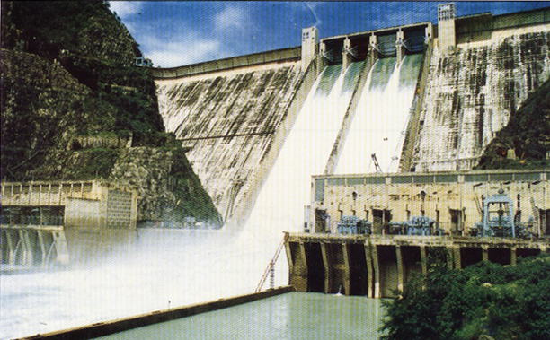
Bhakra Beas Management Board (BBMB, http://bbmb.gov.in/english/index.asp) is the manager of India’s celebrated icons: Temples of Modern India as our first Prime Minister called it. In a rare occasion, when we get a candid account of insider’s view of this organisation, it is worth taking note of it.
Bhakhra Dam: Photo from BBMB
BBMB, created on Oct 1, 1967, has current annual budget of massive Rs 1000 crores and manages the Bhakra Nangal Project, the Beas Project I (Pandoh dam, the Beas Sutlej Link and the Dehar Power House) and the Beas Project II (Beas Dam and Pong power houses). With close to 3000 MW of installed capacity it generates about 12.5 billion units of power annually.
Mr Satish Loomba, who served as Financial Advisor to BBMB between 1996 and 2001 has just provided an interesting view about the functioning of BBMB in his article Need to corporatise BBMB in The Tribune of January 23, 2014: http://www.tribuneindia.com/2014/20140123/edit.htm#6. While the author, as the title suggests, is advocating a corporate restructuring of BBMB, what he has said in the process provides a valuable insights from an insider. Here are some snippets:
Þ “This organisation, which has become heavy, slow and bureaucratic…”
Þ “However, despite a façade of running smoothly, the BBMB, from the organizational standpoint, suffers from several infirmities, limitations and internal contradictions.”
Þ “At the core of the inadequacies in the BBMB are the… systems which do not promote efficiency, cost control and long term health of its vast assets… It has no concern with the value of its output…”
Þ “… capital of the BBMB is not being preserved in accordance with accepted principles…” In fact in recent years, the illegal dumping of humungous quantities of muck (even a 100 MW project creates several million meter cube of muck) by the numerous major, medium and small hydropower projects in upstream Sutlej (see: https://sandrp.in/basin_maps/Hydro_Electric_Projects_on_Sutlej_River_in%20HP.pdf) and Beas (see: https://sandrp.in/basin_maps/Hydropower_Projects_in_Beas_Basin.pdf) basins is leading to accelerated silting up of the Bhakra, Pong and Pandoh reservoirs, but no one, not even BBMB has shown the slightest concern.
Þ “For the ageing irrigation wing assets, which are colossal and could be in sudden need of massive recapitalization…”
Þ “… there is no account which summarises its results for a specific time period…”
This is a very serious indictment, not only of BBMB but also the way the “icons” of India are being managed by an organisation controlled by the Union Ministry of Power. Are these remediable infirmities or are these the implications of the kind and size of structures that BBMB manages? The author of the above article does not even pose this question, but is a very relevant one.
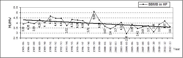
Declining Hydropower generation As per our analysis of hydropower generation from the three BBMB projects in Himachal Pradesh, namely Bhakra (1325 MW), Dehar (990 MW) and Pong (396 MW), with total installed capacity of 2711 MW, the generation per MW installed capacity has shown hugely declining trend with trend line declining by 18-20% in less than three decades. We also have graphs of individual BBMB hydropower projects that show similar trend line. This is a massive decline and in any responsible governance, questions would be asked as to why this is happening, but here, there are no questions.
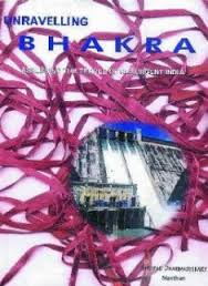
Unravelling Bhakra In a comprehensive critique Unravelling Bhakra, (see: http://www.manthan-india.org/spip.php?rubrique1, available in both English and Hindi), author Shripad Dharmadhikary has shown that it is a myth to assume that Bhakra dams were the only or major reasons behind India’s food security, green revolution or irrigation in North West India. He has shown with facts and figures that are yet to be proven wrong that the contribution of Bhakra dams was limited.
Displaced people still awaiting justice Over five decades after commissioning of the Bhakra project, the people displaced by this most celebrated of Indian dams are still awaiting justice, as is clear from this latest news report (http://www.tribuneindia.com/2014/20140120/haryana.htm#10) in January 2014. This has been highlighted by many in the past including Govt of India’s Water Resources Minister in his autobiography, by SANDRP in 2002, by Shripad Dharmadhikary in above mentioned book and continuous media coverage. This also shows the callous attitude of BBMB and concerned state and central governments.
Ad hoc, callous reservoir operation It is no secret that even this irrigation system is in bad and declining health. This is due to many reasons, including due to lack of maintenance and participatory governance. Several times it has been pointed out how unaccountable and inefficient has been the operation of the Bhakra reservoirs. Two recent occasions when SANDRP pointed this out include the following:
Þ With general elections approaching in coming April May 2014, we have to wait and see if the Bhakra reservoirs will again be operated in an ad hoc manner like it happened before previous two national elections.
We hope right lessons will be learnt from this insider’s view of the alarmingly inadequate functioning of the BBMB and efforts will be made to make its functioning more participatory, transparent and accountable.
Sub: 2700 MW Lower Siang project – Cancel Illegal Public Hearings proposed for January 31st 2014.
Dear Dr. Rajgopalan,
We write to you on behalf of the Forum for Siang Dialogue (FSD), Siang Peoples’ Forum (SPF) Sirit-Siyom Banggo Dam Affected peoples’ Forum (SSBDAPF), Siang Bachao Andolan (SBF), Nyiko Bachao Forum (NBF) to seek cancellation of the Three public hearings proposed to be held for the 2700 MW Lower Siang hydroelectric project in the East Siang, West Siang and Upper Siang districts of Arunachal Pradesh on January 31, 2014.
Through a notification dated 30th December 2013 published in the Arunachal Times dated 31st December 2013 the Arunachal Pradesh State Pollution Control Board (APSPCB) has announced the conduct of public hearings for the 2700 MW Lower Siang project in three districts of Arunachal Pradesh. A scanned copy of the notice is attached for reference (Annexure 1).
There are a number of legal reasons due to which the public hearings need to be cancelled, here are a few of them:
1) Public hearing on the same day and time in the West Siang, East Siang and Upper Siang districts of Arunachal Pradesh
There are a number of local persons/clans/local communities who have land directly affected by the Lower Siang project cross-cutting the district boundaries. Such persons/clans/local communities will not be able to exercise their legal right to participate in all the public hearings in the districts where their ancestral lands are affected, since they are being held on the same day, at the same time. This is a gross violation of the letter and spirit of the EIA notification 2006 as well as the article 14 of Right to equality and article 19, the freedom of Speech under the Constitution of India.
It is crucial that the public hearings are held in the three districts with sufficient days in between to enable the affected persons to participate in the public hearings wherever their ancestral lands are affected.
It cannot be argued that they should put their viewpoints in one of the public hearings in one of the districts. It is their legal right to participate in the public hearings wherever their lands are affected. This is a clear ground for cancellation of the public hearings and re-announcement by keeping sufficient days in between hearings being held in different districts.
2) Location of public hearing venue more than 100 km. away from 11 villages
The public hearing venue fixed for the East Siang district is Pasighat, the district headquarters, in the downstream-affected area of the project. While the APSPCB is welcome to organise a separate public hearing for the downstream-affected area, this is an extremely inconvenient location for the upstream-affected villagers in the East Siang district who are directly affected. And Pasighat town is nowhere listed as an affected village/area/circle in the EIA,EMP and Social Impact Assessment report of the Project Proponent. (Attached is the list of the affected villages as prepared by WAPCOS for the project.
The Public Hearing for Upper Siang District is also fixed at Katan which is 40 Kms away from Geku villages, which is encompassing the majority of the villages to be affected by the dam and above all there are not even a single Govt/Public or Private transport plying/ operating there. And the only village which is going to be completely submerged happens to be Pongging village under Upper Siang district, and the people have to walk on foot covering a distance of 17 kilometers to reach Katan as there is no Public/Private/Govt Transport system plying there.
Out of the 25 villages directly affected in East Siang district, at least 11 are more than 100 kms. away from the public hearing venue! In fact Riga village, one of the severely affected village under East Siang District is 172 km. away from Pasighat. A further nine villages are 60 – 100 km. away. Please note that 6 (Six) villages have to walk for up to 12 km. even before reaching the motor able road.
It is clear that the public hearing venue in East Siang district has been decided in order to disallow active participation of directly affected villages. This is completely unacceptable as per the letter and spirit of the EIA notification 2006 and various court orders/judgements on the need for proximity of the public hearing venue to the affected area. Public hearings cannot be located as per convenience of government officials who do not want to travel to affected areas and stay in the district headquarters. This another strong ground why the public hearings announced for 31st January 2014 have to be cancelled immediately.
And Chapter II U/s 5 of The Right to Fair Compensation and Transparent Land Acquisition Relief and Resettlement Act 2013 also clearly states that Public Hearing should be held in the Affected area and not otherwise.
3) Siang river basin cumulative impact assessment study is not complete and placed in the public domain at designated places before public hearing
Section 9.4 of Form I of the EIA notification requires that cumulative impacts of a project are examined during the EC process. Further the Ministry of Environment and Forests (MoEF) has issued an OM dated 28th May 2013 stating that it will consider hydropower projects based on cumulative impact assessment and carrying capacity studies. The OM is attached as Annexure 2.
The OM states that:
“While the first project in a basin could come up without insisting on cumulative study for all subsequent hydro-power projects in the basin it should be incumbent on the developer’ of the second/other project(s) to incorporate all possible and potential impact of other project(s) in the basin to get a cumulative impact assessment done.”
An important aspect of Appraisal done by EAC/MoEF is detailed scrutiny done of all documents including public consultation proceedings. As per the EIA notification 2006 (section 9.4 of Form I) and the MoEF’s OM dated 28th May 2013 if cumulative impacts studies have to be the basis for decision-making, then such studies have to placed in the public domain at designated places 30 days prior to the public hearing.
However, the Siang river basin cumulative impact assessment is neither complete nor placed in the public domain at the designated places prior to the public hearing. Please note that this study currently underway is looking at all projects in the Siang river basin (Siang and its tributaries).
Although we disagree with the logic that the first project could come up without ‘insisting’ on a cumulative impact assessment study (since that project could be the most ecologically and socially destructive), in this case Lower Siang is NOT even the first project in the river basin for which either a public hearing is being held or being considered for environmental clearance. A number of public hearings have been held for other projects in Siang river basin and projects have also been already considered for Appraisal by EAC/MoEF. In fact 1000 MW Siyom and 700 MW Tato II project in the Siang river basin have already received final environmental clearance from the MoEF.
By no stretch of imagination is the 2700 MW Lower Siang project the first project being considered in the Siang river basin. Therefore as per the MoEF’s own OM dated 28th May 2013, Siang river basin cumulative impact assessment will first have to be completed. Public hearing should only be held after this is completed and these reports are placed in the public domain at least 30 days before the hearing.
Keeping all this in mind we strongly urge the MoEF to direct the APSPCB to cancel the Illegally notified public hearings proposed for the 2700 MW Lower Siang project on 31st January 2014.
Sub: Lower Siang HEP (2700 MW) EIA-EMP Report not fully available on APSPCB website; many links not working; Public hearing will be illegal without full EIA-EMP in public domain
Respected Sir,
This is regarding the EIA-EMP report of Lower Siang HEP (2700 MW) uploaded on APSPCB website. The public hearing for the Lower Siang HEP is schedule to be held on 31st January 2014.
As per the EIA notification of 2006 the full and complete EIA and EMP report should be made available on State Pollution Control Board website, in this case your website at least 30 days in advance of public hearing date as this is necessary not only for the affected people but also for wider consultations for concerned individuals and groups, as required under the EIA Notification. However, full EIA-EMP are not available on your website, with at least three chapters of EIA, one chapter of EMP and several annexures not opening, even ten days before the public hearing date.
It is very surprising and confusing to most people to see that the reports have been uploaded in 145 parts totaling 320 MB file size. These documents should have been uploaded as five reports as done for EIA-EMP report of several other projects. However, we have gone through all the files available on APSPCB website and based on perusal of these files, we find that crucial parts of the statutorily required documents are not available on APSPCB website. The list of missing chapters and annexures with the name of the report is given below. A screenshot of the links to these chapters are also attached and annexure as mentioned below.
No
Chapter/Figure
Report
Status
Attached
1
Chapter 2 – CONCEPT & METHODOLOGY
EIA
Failed to upload
Annexure 1
2
Chapter 10 – AQUATIC ECOLOGY FISH & FISHERIES
EIA
An incomplete, possibly irrelevant table on a 1-page
Annexure 2
3
Chapter 12 – CONSTRUCTION METHODOLOGY
EIA
Failed to upload
Annexure 3
4
Chapter 10 – REHABILITATION & RESETTLEMENT PLAN
EMP
Failed to upload
Annexure 4
5
Fig 3.3 – Gradient profile of Siang river including its major and minor tributaries of the Siang river catchment
EIA
Not uploaded
6
Fig 3.4 – Gradient profile of the Siang river with its main tributaries in the Siang river catchment area
EIA
Not uploaded
7
Fig 7.3 – Land use/ land cover map of the submergence area of the proposed Lower Siang H.E. project
EIA
Failed to upload
Annexure 5
8
Fig. 2.3 – Drainage map of the free-draining catchment area of the proposed Lower Siang H.E. project
EMP
Not uploaded
9
Fig 7.3 & 7.4 – Cross-section at the proposed dumping site
EMP
Incomplete, failed to upload
Annexure 6
We therefore request you to upload these chapters immediately and also upload smaller size single documents of each report for the perusal of the local people and all concerned. In the meanwhile, since non availability of full EIA-EMP on pollution control website a month before the public hearing is a statutory violation, we request you to cancel the public hearing now slated for Jan 31st, 2014 as holding a public hearing without full EIA-EMP on the APSPCB website a month before the PH will not be legally tenable.
Thanking you, we will look for your early response,
Yours Sincerely
Parag Jyoti Saikia
South Asia Network on Dams, Rivers & People (SANDRP), 86-D, AD Block, Shalimar Bagh, Delhi – 110 088