
Guest Blog by Jacob Chandy Varghese (jacob.c.varghese@gmail.com)
An Old Story: I read an account about Netherlands in the journal, Annals of Botany (2010)[i] . This story dates from the 11th century. Many centuries ago, the coastal plain of the Netherlands consisted of a dynamic landscape of meandering river channels, extensive floodplains and large complexes of fens and bogs. Sediment deposition and peat formation kept pace with the gradually rising sea level, so that the level of the land remained well above the water for most of the time. Since 11th century, inhabitants of the low-countries started to modify the hydrology of their surroundings to create protection from flooding for their dwellings and agricultural fields. They built dikes and started to manipulate the water level.
Well, they had to live! And they wanted to be self-sufficient! Quite a noble intent, indeed!
From the 14th century, large scale reclamation started in the peat lands of the coastal plain, financed by local community leaders. In addition to enclosing a peat land area with a dike, numerous parallel drainage ditches were dug, leaving long rectangular lots for crop cultivation. These were farmed with great success, since the mineral content of the peat provided high fertility. This was glorified as the role model behaviour of farming and self-sufficiency.
However, peat oxidation also resulted in subsidence, and the farmers had to turn to livestock and grassland because their land became too wet for crops. They abandoned the very land that gave them food.
So much for the proclaimed love of the land!
In the 17th century, windmills were erected and enabled deeper drainage. The farmers were again able to grow crops, until further subsidence resulted in wet meadows. In the 20th century, water level control became highly sophisticated with powered pumping stations, and levels of fertilizer and pesticide use increased. 4 m of peat has disappeared through drainage and oxidation in the last millennium. The deepest areas are now more than 7 m below mean sea level. The rates of subsidence as well as of sea level rise have increased recently, and are expected to increase further as a result of climate change.
The point to notice in this story is that, there is nothing in the story that we can really call greed. It was called food revolution. You could always justify it based on the growing demands for food. But then, greed came in, and the silent baby, the peat lands, starved. So, the land which was well above sea level in 11th century has now become 7 m below sea level. And we put all the blame on global warming, as if we poor human beings are suffering the fury of nature!
An indigenous story – Kerala, and the modern history of nature
Now, what happened in the land of Kerala, is a story which is not as pretty as this, and happened in a much shorter time span. In Netherlands, there was at least an apparent noble intention of growing more food. Not here. This story was told to me by Mr. Arch Bald and Prof. Peter Pradeep of the Help Foundation[ii] in Kerala.

The story I heard from HELP Foundation was centered around the water bodies of Kollam, namely the Ithikkara river, Paravur kayal (lake) and Ashtamudi lake. But I guess the story is the same for any lake and river combination in Kerala.

From the Western Ghats to the sea – Nature’s architecture
The Western Ghats is the source of the Ithikkara river, which dissolves in Paravur lake. This river runs 56 km before it reaches Paravur lake. Water flow from the river to the lake is almost continuous. During the non-rainy season, this water from the Western Ghats, which is enriched by the Western Ghats ecosystem, gets stored near the estuary. This actually becomes ekkal (sediments or natural manure). During this time, the fish eggs also develop under the mangroves and get enriched by the feed from the Western Ghats. The ekkal settle in paddy fields, the water from the Western Ghats settle in the underground aquifers and flow through the underground channels. And in these fresh water bodies (aka wetlands aka paddy fields) fishes thrive.
The natural estuary was the route through which the nutrient-rich waters entered the sea, through the lake. When monsoon starts, the water gushes down in full force, breaks the estuary, the natural one, and enters the sea. The estuary (pozhi) opens and the ekkal flows out to the sea. All these gather somewhere in the sea where there are no waves, due to the opening of the estuary. Now where this ekkal comes and settles down, fishes come in hoards. This is called chaakara (great harvest of fish). When the estuary breaks, saline water from the sea also enter the fresh water lake as well in the reverse direction. In the process, fish from the sea move inland and lay eggs amongst the mangroves. When the monsoon season ends and the inflow of fresh water slows down, the natural estuary (sand bar) gets formed again and the lake closes its mouth to the sea. The eggs would have given way to young finger lings by now and they grow to be mature fish which is livelihood for the traditional fishermen. Hence the saying that estuaries are the nurseries of the sea. After the estuary closes, water becomes fresh again. When the estuary gets opened up again during the next rainy (monsoon) season, fishes from the lake which are grown up by now move back to the sea and as before fishes from the sea enter the lake to lay eggs. The fishes from the sea that enter the lake would go and lay eggs under the mangroves. Once the rain is over, the natural estuary closes by itself, and the lake and the sea are once again separated. The cycle repeats. This is how nature’s bountiful valve mechanism worked, and both sea-faring fishermen and traditional inland fishermen were catered to by nature.
The beginning of “Development”
Paddy fields (wetland) were created for agriculture (rice farming) using bunds. They were given to people to cultivate. After a few years, the farmers went on a strike and the fields became fallow as agriculture stopped. The alleged real reason for the strike was that the owners were supposed to share a percentage of the produce, they did not do so, and the labourers refused to do the work.
However, by sheer coincidence, the Persian Gulf jobs trend in Kerala started around then, money started flowing in to Kerala from the Gulf, and the demand for bricks went up because of increased construction demands in the housing sector. And the mud in Itthikkara river was found to be excellent for bricks, and they needed more. They also wanted the sand (from the river bed) for the cement and concrete. For this, they wanted to stop the infusion of salt water into the inlands. They took advantage of the farmers’ strike, and apparently reported that the agriculture stopped because of salt water infusion into the fields. Based on this, the government decided to close the natural estuary (pozhi) and then opened a spillway (cheeppu) at a wrong location (at a 75 degree angle to the river) thus rendering the spillway ineffective. Only surface water slowly oozed out. The river continued to its quest to amalgamate with the sea, knocking at the very spot where the estuary would have opened up naturally.
Human Engineering replaces Nature’s architecture
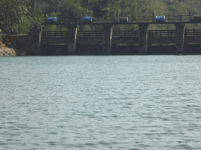
The natural pozhi refused to close but then they dumped granite boulders in 1986, which finally closed the estuary. (See Photo). How sad! Don’t you see a struggle of a living entity called river with other living entities called humans? The spillway was made with extremely poor quality of steel, so that by a combination of rusting and poor maintenance, the spillway’s quality got severely damaged. Now the estuary is gone and the spillway is ineffective when copious water gushes in during monsoons. (See Photo)

So in the absence of the pozhi, (the natural estuary formation), the lake got filled up with sediments and pure water continuously flowed into the sea through the spillway. This resulted in huge scarcity of drinking water during summer months.

A validation from the recent floods
During the Aug 2018 floods, we witnessed a clear evidence of the consequences of tampering with the natural estuary. According to a recent news report in the daily, Deccan Chronicle (Aug 21, 2018), “During this flood, the district administration had to channel the excess water by cutting open an outlet at a spot parallel to the original estuary. Each time while the water is let out by tunneling, the Government loses huge money. The construction of spillway in the North-South direction is purely unscientific, since the Ithikkara river flows into the Paravur lake from the Eastern direction and flows straight to the West. And to make matters worse, the spillway is constructed some 500 meters away from the natural estuary. This has also resulted in sand deposits formed during the high tide, considerably reducing the water storage capacity of the lake.” (See photo of Deccan Chronicle article).

So, with the natural estuary being forced to death, and the alternative, the spillway being inefficient in operations, and with the construction of fishing harbor, all the natural mechanisms which we saw earlier which linked the Western Ghats to the lakes and sea went into an imbalance, and have slowly vanished.

The other side effects of “Development”
Many other factors also contributed to the destruction of the ecosystem. One was sand mining, which destroyed the natural clay structures under the surface and as they started getting destroyed, and all the natural channels vanished. The whole network of channels under the ground vanished further when mechanization was incorporated to assist sand mining. So, any possibility of fresh water storage and finally recharging the water table to underground aquifers vanished with that.
Another factor that contributed to the depletion of natural ecosystem in the last two to three decades was the razing of the hillocks for construction to convert them as prime real estate. Now there are no more obstacles for the river run off rate to be slow, so it can get absorbed into the water table under the surface it flows. So instead of meandering across the valleys in its natural gradual way, the river just races fast to the sea. Around forty years ago, the rain water from our catchment areas on the Western Ghats reached the Arabian sea in three or four weeks’ time. Now it hardly takes 48 hours due to rapid urbanization. Day by day, nature is losing her capacity to absorb, store, preserve, slowly release water, which makes man-made preservation of water all the more mandatory.
Also when paddy fields were there, they were also flood plains. When the river is in spate and it overflows, it gets absorbed in the flood plains. However, with absence of agriculture, a lot of paddy fields (wetlands) were filled up for creation of valuable real estate. This destroyed the flood plains and its ability to absorb water. Now, when heavy rainfall occurs, it is deluge all over the place. In the recent floods near Kollam, the land which was next to large acres of paddy fields did not get affected to a destructive extent because of the heavy sinking in the flood plains of the paddy fields. And during summer months, this water from the flood plains gets released into the rivers. Where there were no flood plains , the land and houses submerged, but with no ability to hold the water, when the floods receded, all the water also receded, with no advantage for future drawn from this exceeding abundance of water.
The fourth factor that contributed to the destruction of the ecosystem was the construction of fishing harbours. Where there was a pozhi (estuary), they created an azhi (harbor) which is always open, and these became fishing harbours. So, continuous flow was enabled from sea to the lakes, thereby worsening the issue of salinity intrusion into fresh water bodies. It is interesting that in the same speech the politicians speak about absence of drinking water, and in the same breath they talk about opening a fishing harbor (quietly destroying the estuaries).

Restoration of wetlands ecosystem – The mangrove way
Amidst all the fights to educate the people on the estuary and need to protect and preserve wetlands, HELP Foundation does mangrove plantations across the banks of the Paravul lake, see photo.
Mangroves are very sensitive plants. Once the mangroves successfully grow on the waterline of the lake, and sufficient aerial roots are formed, there will be prevention of any further erosion of the shore, and there will be effective desalination by the mangrove plants. The aerial roots of the mangroves will provide the right ambience and still waters for fish to lay eggs. The desalination provided by mangroves will help the fish population to thrive and grow. There will be increased availability of potable water in the wells in the region. This is primarily due to the desalination of water by the mangroves, and the retention of abundant water because of prevention of erosion of the shores. The mangrove “wall” with its aerial roots will also provide a strong border preventing easy disposal of human waste.

Let’s build hope
The story is probably similar for many of the rivers in Kerala. While we cannot undo a lot of the damage, we can arrest further deterioration, and rejuvenate our rivers and lakes. We need to see what we can do to save further damage and restore the ecosystem. We need to understand the natural estuary functioning and see if something can be done to restore the damage. We need to understand what is needed for our rivers and lakes, and do our best to prevent any further degradation. We need to understand the role that wetlands play as part of flood plains to buffer the periods of water abundance and water scarcity.
When we replace natural designs with human engineering, the immediate results look very attractive. However, if we were to take a Net Present Value (NPV) as we say of financial investments, the returns are terribly negative. Unfortunately, the first generation that destroys nature benefits from it and even glorifies the human engineering. It is for the subsequent generations to suffer the negative returns.
The noted educationist, Paulo Freire said once, that literacy should be not just about teaching people their alphabets, but should be evolving to a level of critical literacy which teaches you to question the things around you. Kerala, the land which talks of 100% literacy, needs to open its eyes to the need of critical literacy, and thereby take the lead in showing the world how we can restore parts of the nature that we destroyed.
By Jacob Chandy Varghese, Descant (jacob.c.varghese@gmail.com)
[with inputs from Arch Bald & Peter Pradeep of HELP Foundation, Kerala (www.helpfoundation.in)]
END NOTES:
[i] Details about the Netherlands peat land depletion from Verhoeven, T. A, Setter, T. L (2010) Agricultural Use of Wetlands: Opportunities and limitations. Annals of Botany 105, 155-163)
