
The release of around 1.31 lakh cusecs of water in Yamuna from Hathnikund barrage at 09:00 hours on July 26, 2018, was certainly first surge of flood this monsoon in the river. But no one expected, most are still in the dark that the release would multiply by over five times in just two days! It is almost a month after the Southwest monsoon arrived. By this time the river usually floods couples of times.
Looking at the lack of significant rainfall in the catchment area over past weeks, the flood is unexpected and has taken many by surprise. The Irrigation and Flood Control Department, Delhi Government has issued warning for flood plain farmers and human settlements close to river banks, but the warning does not seem to commensurate with the flood peak that is likely to hit the capital in next day or two.

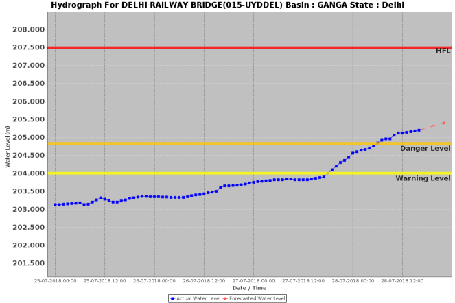
Yamuna has already crossed warning (204 m) and danger level (204.83) at Old Delhi Railway Bridge (ORB), Delhi. The High Flood Level is 207.49 meters, reached on Sept 6,1978 after around 7 lakh cusecs (cubic feet per second) water was released in Yamuna on 3rd Sept 1978 at 04:00 hrs from Tajewala barrage, that was decommissioned and replaced by Hathnikund barrage in early 1990s. The flood monitoring of River Yamuna began in 1963.
Since then, the river has seen high floods in 1988, 1995, 2010 and 2013. The 2010 and 2013 floods also crossed 207 metres mark but fell short of 1978 level.
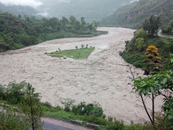
However, for the last three days, there has been significant rain in the Yamuna catchment in Himachal, Uttrakhand, Haryana and Uttar Pradesh. The river has started swelling and what first was believed to be a mild flood spell is turning out to be big flood event.
The discharge of about 2 lakh cusecs flood can cause a low level flood in Delhi. Discharges between 3 to 5 lakh cusecs can result in medium scale flood in the capital. And the discharge beyond 5 lakh cusec from Hathnikund can bring a big flood in Delhi submerging floodplains and threatening the embankments.
Usually the first flood spell reaches Delhi in about 72 hours. Once river bed and adjoining area are saturated by rain and river discharges, the flood water takes about 60 hours to reach the threshold of Delhi. As per CWC forecast, the discharges mentioned in the table below will be taking about 62 hour’s time to reach Delhi.
Discharge from Hathini Kund Barrage on 28 July 2018
| SN | Time | Discharge
( In lakh cusecs) |
| 1 | 0700 hrs | 1,80,000 |
| 2 | 0800 hrs | 1,93,607 |
| 3 | 0900 hrs | 2,11,874 |
| 4 | 1000 hrs | 2,55,137 |
| 5 | 1100 hrs | 3,11,190 |
| 6 | 1200 hrs | 3,56,717 |
| 7 | 1300 hrs | 4,24,763 |
| 8 | 1400 hrs | 4,80,557 |
| 9 | 1500 hrs | 5,03,925 |
| 10 | 1600 hrs | 5,03,925 |
| 11 | 1700 hrs | 5,27,362 |
| 12 | 1800 hrs | 6,05,949 |
| 13 | 1900 hrs | 5,63,186 |
| 14 | 2000 hrs | 5,63,186 |
Flood situation at different locations along Yamuna:
Badkot, Uttarkashi The river has reportedly engulfed several adjoining farmlands at Tiladi ghat. An electric poll has been washed away at Kharadi and retaining wall of an under construction bridge has also been damaged at Than village. The bridge, incidentally was washed away in 2010 floods and has not been rebuilt since then.


Yamuna River water level at Mungra Bridge Naugaon, 28 July 2018 (Map source; CWC & Image by Tilak Ramola)
At Naugaon, the river has touched 1059.60 metres mark on 28 July 2018 around 12 hours at Centre Water Commission (CWC) level monitoring site located downstream of Mungra bridge. The highest flood level was marked 1060.40 at this location in 2010. So this seems to be a huge flood after 2010. The water level has stabilised and started showing downward trend but ongoing rain could swell the river dangerously.
Katapathar, Vikas Nagar, Dehradun The river channel is full. At 15 hours on 28 July 2018 it was reported to be rising further. Local people say that the river reminds them of 2010 flood when a long patch of Khair forest on a river island was swept away like dry twigs.
Video showing flooded Yamuna river at Vyasi Hydro Power Project, Juddo, Dehrudun (Video by Parveen Tomar, Katapathar, 28 July 2018)
The floods then had also damaged the Bausan flood monitoring site. It was later buried under the debris of Vyasi Hydro Power Construction. The CWC seems to have not rebuilt the flood monitoring site. The normal life has been affected and people are staying indoors fearing landslide or other flood disaster. The Ponta level monitoring site is rising constantly and has touched 382.500 metres mark at 17 hours on 28 July 2018.

Kanalsi – Yamuna Nagar 1.81 lakh cusecs water was released in River Yamuna on 26 July 2018 at 19:00 hours. Since then on an average 1 lakh cusec plus water is flowing in the river. As per villagers the river started eroding banks downstream Kanalsi village in Yamuna Nagar, Haryana. The villages located close to river banks have been alerted about rising water level.

The rain has stopped there, but given the water level and discharge rise at Poanta and Hathini Kund Barrage, Yamuna Nagar, there would be more and bigger discharges in the river which may cause bank erosion and threat to embankments in Karnal and Paipat. The water level is rising at Kalanaur (UP), Karnal (Haryana) and Mawi (UP) level forecasting site.


(Hydrographs for Kalanaur and Mawi sites show rising trend on 28 July 2018)
Delhi The flood level in Delhi is on constant rise. There are three flood monitoring site in Delhi which are Palla, Jhangola and Old Railway bridge. The river has already crossed warning and danger level.

The present water level at Palla is at 210.3 metres. It is rising up and will cross the warning level of 210.6 metres and may touch the danger level of 211.8 metres. Flood water has started spreading in floodplains. The floodplain farmers have been put on alert. If it rains more, Delhi may well see a bigger flood spell.
About CWC Flood forecasting and level monitoring sites.
List flood forecasting and level monitoring sites in Yamuna Basin
List Flood Forecasting Sites
| SN | River | Site | District/ State | WL | DL | HFL (M) | HFL Date |
| 1 | Yamuna | Paonta | Sirmaur, HP | 383.5 M | 384.5 M | 384.6 M | 05-09-1995 |
| 2 | Yamuna | Karnal | Karnal, Haryana | 248.8 M | 249.5 M | 250.07 M | 17-06-2013 |
| 3 | Yamuna | Mawi | Muzzafar Nagar, UP | 230.0 M | 230.85 M | 232.75 M | 18-06-2013 |
| 4 | Sahibi | Dhansa | South West, Delhi | 211.44 M | 212.44 M | 213.58 M | 06-08-1977 |
| 5 | Yamuna | Delhi Railway Bridge | North, Delhi | 204.0 M | 204.83 M | 207.49 M | 06-09-1978 |
| 6 | Yamuna | Mathura (Prayag Ghat) | Mathura | 165.2 M | 166.0 M | 169.73 M | 08-09-1978 |
| 7 | Yamuna | Agra (J.B.) | Agra, UP | 151.4 M | 152.4 M | 154.76 M | 09-09-1978 |
| 8 | Betwa | MOHANA | Jalaun, UP | 121.66 M | 122.66 M | 133.35 M | 11-09-1983 |
| 9 | Yamuna | Etawah | Etawah, UP | 120.92 M | 121.92 M | 126.13 M | 11-09-1978 |
| 10 | Yamuna | Auraiya | Auraiya, UP | 112.0 M | 113.0 M | 118.19 M | 25-08-1996 |
| 11 | Yamuna | KALPI | Jalaun, UP | 107.0 M | 108.0 M | 112.98 M | 25-08-1996 |
| 12 | Yamuna | SHAHIJINA | Hamirpur, UP | 103.54 M | 104.54 M | 108.67 M | NA |
| 13 | Ken | BANDA | Banda, UP | 103.0 M | 104.0 M | 113.29 M | 07-07-2005 |
| 14 | Yamuna | HAMIRPUR | Hamirpur, UP | 102.63 M | 103.63 M | 108.59 M | 12-09-1983 |
| 15 | Yamuna | CHILLAGHAT | Banda, UP | 99.0 M | 100.0 M | 105.16 M | 06-09-1978 |
| 16 | Yamuna | NAINI | Allahabad, UP | 83.74 M | 84.73 M | 87.99 M | 08-09-1978 |
List of Level Monitoring Sites
| SN | River | Site | District | State | HFL (M) | HFL Date | |
| 1 | Yamuna | Hanuman Chetty | Chamba | Himachal Pradesh* | NA | NA | |
| 2 | Yamuna | Naugaon | Uttarkashi | Uttrakhand | 1060.4 m | 11-09-2010 | |
| 3 | Pabar | Tuini (Pabar) | Dehradun | Uttrakhand | 931.88 M | 25-09-1988 | |
| 4 | Tons | Tuini (Tons) | Dehradun | Uttrakhand | 904.0 M | 24-09-1988 | |
| 5 | Tons South | Haripur | Dehradun | Uttrakhand | 482.48 M | 25-09-1988 | |
| 6 | Yamuna | Kalanaur | Saharanpur | UP | 268.66 M | 08-09-2010 | |
| 7 | Yamuna | Masani | Rewari | Haryana | 242.58 M | NA | |
| 8 | Hindon | Galeta | Baghpat | UP | 217.72 M | 04-09-1978 | |
| 9 | Yamuna | Baghpat | Baghpat | UP | 217.18 M | 27-08-1988 | |
| 10 | Sahibi | Dadri | Jhajjar | Haryana | 214.98 M | 26-08-2008 | |
| 11 | Yamuna | Palla | North West | Delhi | 213.275 | 1988 | |
| 12 | Betwa | NAUTGHAT | Jhansi | UP | 207.99 M | 01-09-1983 | |
| 13 | Yamuna | Mohna | Faridabad | Haryana | 193.13 M | 06-09-1978 | |
| 14 | Yamuna | Mathura (Gokul Barrage) | Mathura | UP | 166.17 | 26-09-2010 | |
| 15 | Chambal | UDI | Etawah | UP | 128.4 M | 24-08-1996 | |
| 16 | Yamuna | RAJAPUR | Chitrakoot | UP | 96.37 M | 07-09-1978 | |
| 17 | Yamuna | PRATAPPUR | Allahabad | UP | 90.1 M | 08-09-1978 | |
| 18 | Betwa | Matatila | Lalitpur | UP | NA | NA | |
List of Inflow Monitoring sites
| SN | River | Sites | District | State | FRL | MWL |
| 1 | Yamuna | Hathinikund Barrage | Yamuna Nagar, | Haryana | NA | NA |
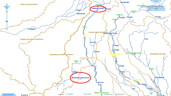
| 2 | Yamuna | Tajewala Weir (Hathinikund) | Yamuna Nagar, | Haryana | NA | NA |
Overall there are 36 flood forecasting, level monitoring and inflow monitoring stations comprising of 16 Flood forecasting, 18 Level monitoring and 2 Inflow monitoring station on River Yamuna and its tributaries in Uttrakhand, Himachal Pradesh, Haryana, Delhi and Uttar Pradesh states.
Serious lacunae in CWC flood forecasting in Yamuna basin As we see, there are several problems with the CWC flood monitoring system[i]. A few are mentioned here.
- The Hanuman Chuttey site is in Uttarkashi, Uttrakhand but CWC website shows this in Himachal Pradesh. It is the first level monitoring site on River Yamuna close to its origin downstream the confluence of Hanuman Ganga. But the site is inactive, hence there is no information about river water levels from this site.
- The Bausan site at Katapathar, Dehradun has been damaged in 2010 and currently is non-functional and buried under the debris of Vyasi Hydro Power Project. Hence there is no forecasting or monitoring station when river Yamuna enters the plains from mountain area.
- The sites shown with red colour are lying inactive. These sites should have been active or removed from CWC flood forecasting list.
- The sites in the table with green colour has no information about high flood levels and date but the hydrograph for these site is active. CWC should provide complete information about these site.
- Similarly the Full Reservoir levels and Maximum Water Level is not mentioned for the two inflow monitoring sites.
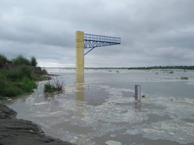
- The Tajewala Weir is completely destroyed by 2010 floods but it is still shown on the website, though without any information. The location of the site is also wrongly shown far away from its location on Yamuna river, in Yamuna Nagar to South Haryana, along Sahibi river.
The coming floods will further test the Delhi govt, CWC and the disaster management systems and of course the people all along Yamuna as the flood travels further downstream of Delhi.

Bhim Singh Rawat, SANDRP (bhim.sandrp@gmail.com)
END NOTES:
[i] http://www.india-water.gov.in/ffs/current-flood-forecast/
Post Script:-
As latest CWC hydrograph Yamuna river level has reached 205.50 metres and about 1500 people have been evacuated from floodplains in Delhi. https://www.news18.com/news/india/as-yamuna-flows-above-danger-mark-1500-delhiites-evacuated-from-low-lying-areas-1826995.html ( 29 July 2018)


Very good and timely report.
LikeLike