
We are happy to publish full text of an Open Letter written by Dr. T.V. Ramchandra, Center for Ecological Sciences, Indian Institute of Science, to Karnataka CM Shri. Siddaramaiah. The letter transparently questions Yettinahole Project, while strongly rebutting Karnataka Neeravari Nigam Limited’s (KNNL) propaganda against IISC Report which has established that Yettinahole Catchment does not have the 24.01 TMC water as per KNNL DPR, but only about 9 TMC water, which is used by the basin residents. (https://sandrp.wordpress.com/2015/05/21/yettinahole-diversion-project-literally-holds-no-water/). He does not limit himself to hydrology and ecology, but with detailed rainfall analyses, also debunks the fact that Kolar and Chikkaballapur face acute water scarcity. He staunchly bats for rainwater harvesting, rejuvenating lakes and tanks and afforestation with native species as cheaper and more reliable method to ensure water availability. Continue reading “Scientist’s Open Letter to Karnataka CM: “Yettinaholé project is ecologically disastrous and economically unviable””
Tag: Gundia
Yettinahole Diversion: An imprudent, Rs.100 Billion proposition
Background Karnataka has been mulling over diverting waters of the west flowing rivers to the east for many years. Netravathi-Hemavathy Link was proposed by the National Water Development Agency (NWDA) as a part of peninsular component of the River linking project. In the meantime, Karnataka appointed a committee under the leadership of Dr. G. S. Paramshivaiah which worked on a plan to divert waters from west-flowing rivers including Netravathi to 7 districts of Bayaleseeme region including Kolar, Bangalore, Tumkur, Ramanagara, Chikmagalore, Chikkaballapur, etc.

But currently, the Karnataka Government is seriously considering Yettinahole Diversion Project which plans to divert head waters of the Gundia River ( a tributary of the Kumardhara, which is a tributary of the Netravathi) in the west and transfer this water to the other end of the state, in the east. It has been reported that tenders for this project have been floated already. Its Project Report (June 2012 version) is titled as ‘Scheme for diversion of flood water from Sakleshpura (West) to Kolar/ Chikkaballapra Districts (East)’.
NOTE, SANDRP: 4 Sept 2014:
Following the efforts of several groups, including SANDRP, Yettinahole Project was strongly opposed, though advocacy and on-ground struggle. In response, the Karnataka government has made substantial changes in the DPR of the Project which was completed in late 2013/early 2014. Several elements have been changed cosmetically, to counter our valid points, thus vindicating the points raised below. SANDRP has published a detailed assessment of this DPR. It can be found here: Yettinahole DPR: New Avtaar, Old Problems. https://sandrp.wordpress.com/2014/09/18/yettinahole-diversion-dpr-new-avataar-old-problems/
~~
In Karnataka Budget Part I, February 2012, Rs 200 Crores have been allocated for making DPR and initial works while Rs 2670 Crores have been sanctioned and Rs 850 Crores allocated in 2013-14 for lift works upto Harvanahalli in Sakaleshpura.[1] All these allocations have been made without a Detailed Project Report, cost benefit assessment, options assessment or environmental and social appraisal of the scheme, or any statutory clearances. This is highly problematic as this assessment indicates that this energy intensive project will have profound impact on Western Ghats biodiversity, wildlife and livelihoods
______________________
SANDRP analyzed the Project Report (PR) which was obtained under RTI by Mr. Kishore Kumar Hongadhalla, who had specifically asked for a ‘Detailed’ Project Report. The total cost of the project as per the PR is 8323 Crores. But the estimate does not include many costs like Rehabilitation and Resettlement (R & R), complete land acquisition, construction of reservoirs on Palar Basin as mentioned in the Project Report, pipeline to 337 tanks, Forest NPV, etc. If these are included, cost of the project will certainly go beyond Rs 10000 crores /Rs 100 billion.
______________________
Purpose of this scheme is stated as drinking water supply to Kolar and Chikkaballapur Districts. However, analysis of the Project Report indicates that drinking water to be supplied to Kolar and Chikkaballapur will be a bare 2.81 TMC or 11.7% of the 24.01 TMC diverted. If water is supplied to Bangalore (urban) as is said in the Budget, but not the Project Report, then water supplied to Kolar and Chikkaballapur will be even less, possibly nil.
_______________________
Analysis of the Project Report and site visits to Yettinahole and surrounding catchments indicate that this project is economically, socially and technically inviable and will have a massive impact on the ecology of the Western Ghats and eastern plains. The analysis also assesses the claim of providing drinking water to Kolar and Chikkaballapur: whether it is viable, desirable and optimal option.
I. The Project
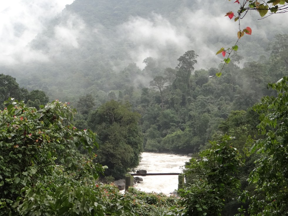
The project involves construction of 8 dams in 2 phases at the head waters of Gundia River basin, a tributary of Kumaradhara, which in turn is a major tributary of the West flowing Netravathi River, the lifeline of Mangalore and Dakshin Kannada districts. The Project Report insists on calling these as weirs, but the drawings[1] indicate the height these dams as 15 meters from deepest foundation, making them large dams, as per the definition of International Commission on Large Dams {ICOLD}.
Dams and rising mains in Western Ghats: 2 dams are planned across Yettinahole stream, 2 on its tributaries, 2 across Kadumanehole stream, 1 across Kerihole stream and 1 across Hongadhalla stream. All these streams are rivulets which join at various points to make river Gundia. Rising mains (large pipelines that transport water under pressure) from these projects will pump water into 3 delivery chambers. From the delivery chambers, water will be lifted to an intermediate pumping station at Doddanagara in Sakaleshpur. From Doddanagara, water will be lifted again and conveyed to Delivery chamber 4 located near Harvanahalli in Sakaleshpura.

233 kms long Gravity canal: From Harvanahalli, water will flow through a gravity canal of 233 kms (Proponent says 250 kms in MoEF Meeting) in length to Tumkur.
Devaranya Durga Reservoir: From Tumkur, again the water will be lifted through a rising main and will culminate into a reservoir to be built at Devaranyadurga. This reservoir will have a height of 68 meters and gross storage capacity of 11 TMC. It will submerge approximately 980.4 hectares of land, including forests.
When this project was discussed in the Expert Appraisal Committee meeting of the Ministry of environment and Forests, the proponents have claimed that Devaranyadurga Reservoir will submerge 1200 hectares of land, of which 50% will be forest land and will also submerge at least 2 villages.[2]
From here, two rising mains of 80 kms and 55 kms will again lift and convey water to Chikkaballapura and Kolar respectively. In Chikkaballapura and Kolar, the rising main will feed various streams and rivers and will have dedicated pipelines to feed Minor Irrigation (MI) and Zilla Parishad (ZP) tanks. Scheme envisages feeding 198 tanks in Chikkaballapur and 139 tanks in Kolar District.
The scheme envisages providing 14 TMC for Hassan, Chikkamagalore, Tumkur and Bangalore rural and 10 TMC for Kolar and Chikkaballapur, through the dam at Devaranyadurga. So, the claims that Kolar and Chikkaballapur will get 24 TMC water is false. The project report is titled ‘Scheme of diversion of floodwaters to Chikkaballpur and Kolar’ but these districts seem to be getting less than 50% of the diverted water. As we see in later sections, of this 10 TMC barely 2.81 TMC is earmarked for drinking water supply.

New Reservoirs planned
- Chikkaballapur District:
- New reservoir across Kushavathy River at Gudibande.
- A new reservoir At Timassandra across Palar river
- Kolar District: Bethmangala Tank to be used as an important reservoir
- At Tanadihalli on Palar River North to store 2.20 TMC water
Electricity needed: As per the project Report, the scheme will require massive 370 MW of electricity.

Volume of water to be diverted: 24.01 TMC water is proposed to be diverted between June-November from a catchment area of 89.66 sq kilometers (8966 hectares). It has to be noted that 24.01 TMC water is available at 50% dependability. So, in 50% years under consideration, 24.01 TMC volume would not be available for diversion. The structures and conveyance system has also been designed at 50% dependability. This may imply several things:
- The scheme can work beyond June-November
- The scheme can divert more than 24 TMC waters from Yettinahole
- The scheme can be used later for diverting waters of other rivers.
This further warrants a serious look at the entire project.
II. Environmental Impact of the Project on Western Ghats and other regions
Impact on Forest Land and Wildlife
The exact extent of revenue, private, agriculture and forest land required for the scheme is not known from the PR. The report (Volume II, Estimates) mentions a head ‘clearing of thick forest by burning’ under costs for laying rising mains from dams to pumping stations. According to these estimates, 107.27 hectares of thick forests will have to be cut or burnt for the rising mains alone.
The forest land involved in submergence of dams, approach roads, workers colonies, muck dumping sites, electrical substations, mining of materials for the project, destruction due to blasting, etc. will be additional. The project report does not provide any of these details.
Most of the forests in the vicinity of Yettinahole, Kadumane hole, Kerihole and Hongadhalla are not only reserved forests, but important wildlife corridors. When IISC studied this region it recorded 119 trees species, 63 shrubs and climbers, 57 herbs and 54 pteridophytes[3], 44 species of butterflies, 4 dragon and damsel flies, 23 species of amphibians including the threatened Gundia Indian Frog, 32 reptiles, 91 birds and 22 mammals including Tiger, Lion Tailed Macaque, Elephant, Slender Loris and Gaur.

The region is witnessing rising man animal conflicts due to destruction and degradation of habitats. During 2002-2012-13, 34 people have died and 17 elephants have been electrocuted in Sakaleshwar Taluk alone (http://www.thehindu.com/news/national/karnataka/elephant-encounter-is-an-everyday-affair-for-them/article4874172.ece). The Karnataka Elephant Task Force has acknowledged the impact of mini hydel projects in Sakaleshpur on Elephant corridors and has given strong recommendations about reviewing clearance and canceling projects which affect elephant distribution areas negative and do not comply with existing laws.
Dams, roads, blasting, muck disposal, workers colonies, sub stations, increased traffic in this region will have a pronounced impact on the wildlife, including the elephants. Any more stress on these regions will precipitate in furthering of conflicts and disturbance.
Environmental Flows As per the working tables, all inflow from the headwaters will be diverted for the most of June, parts of July and August and all of September, October and November. The streams will be completely dry for most days during this period. (Project Report Vol. I, Page A 21) There has been no provision made for environmental flows. This will be extremely damaging for the downstream ecology, wildlife and forests. This issues needs urgent attention and studies.
The scheme may look inviable if eflows are released, as they must be, from the dams/ dams into the downstream river.
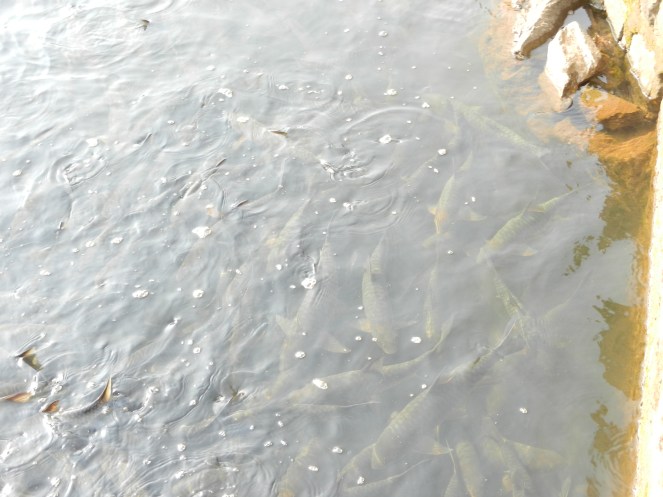
Impact on fish assemblages and fish sanctuaries Kumaradhara and Netravathi are home to some rare community conserved fish sanctuaries. Fish sanctuaries exist at Kukke Subramanya, Nakur Gaya and Yenekal, all of which are downstream from the proposed diversion. The fish assemblages, their feeding and breeding patterns are highly affected by flow. Any drastic changes in flow regime will affect these species.
Gundia River itself has several rare and endangered fish species. 3 new fish species have been discovered and 1 rediscovered in Kumardhara river basin between 2012-13[4]
Blasting using dynamite The project report and estimates state that hard rock will need to be blasted extensively with dynamite. Dynamite blasting will have severe negative impact on the wildlife of the region. Blasting also has documented harmful effects on groundwater aquifers and can affect the existing water sources and water holes of the wildlife.
Muck generation and disposal As per the project report, muck generated for laying the rising mains alone will be to the tune of 13,02,837 cubic meters. All of this muck will be generated close to the rivers, in forest areas. Dumping of this muck will have a huge negative impact on water quality, forests and wildlife. Uttarakhand disaster in June 2013 highlighted the how muck is routinely disposed into rivers and the havoc this causes in the downstream.
Additional muck will be generated during dam/ dam construction, approach, colonies, substations, etc. The impact of this will be compounded.
Approach roads, workers colonies All the dams/ dams, rising mains, electric substations will require approach roads which will pass through forests, further impacting forests and wildlife. Workers colonies and waste disposal will again have additional impacts on the region.
Diverting entire rivers and not just floodwaters The scheme purports that it is diverting only the flood waters of these rivers. However, the yield of all the rivers at 50% dependability between June-November is 28.94 TMC, out of which 24.01 TMC will be diverted. This leaves just 4.93 TMC for the downstream. This is maximum diversion of the rivers and not just ‘flood waters’ or overflow.
Also, even when rainfall is low, the scheme will divert all available water till it gets its share of 24.01 TMC, which will then dry the rivers completely in the downstream.
These are monsoon-fed rivers. Only source of water for these rivers is the monsoon, which also replenishes groundwater, which constitutes the base flow in non-monsoon months. This diversion in monsoon months will have a huge impact on water availability in non-monsoon months also in these rivers and which in turn will have impact on the biodiversity and livelihoods.
III. Supposed Beneficiaries: Contradictions between Budget and Project Report
As stated (verbatim) in the Project Report, following are the beneficiaries of the project (Project Report Volume I: Section 4.7, Page 52)
- Selected parts in Hassan District
- Selected towns in Chikmagalur, Chitradurga by feeding Vedavathi river
- Tumkur, Madhugiri, Pavagada and Koratagere Taluk
- Chamrajsagar reservoir
- Water to Devanhalli Industrial Area
- Augmentation of Hesarghatta tank
- Water to Chikkaballpur and Kolar District
In addition, water will be used to rejuvenate Rivers like Arkavathy (Cauvery Basin), Palar, (Independent basin) Jayamangli, Kushavathy, Uttara and Dakshin Pinakini, Chitravathi and Papagni rivers (Pennar Basin) (Project Report Volume I: Section 4.9, Page 52)
The project report makes no mention of supplying water to Bangalore urban area or BBMP (Bruhut Benguluru Mahananagara Palike). However, the Karnataka Budget 2012-14 specifically mentions providing water to these areas.
How much water will this be? What are the options of water supply to Bangalore? If water is supplied to voracious Bangalore and Devanahalli Industrial area, will there actually be water for Kolar, Chikkaballapur and other drought affected areas?
River Rejuvenation: Long distance transfer of water involving huge ecological, social and financial costs seems to be a poor way of rejuvenating rivers. Experts claim that rejuvenating rivers like Arkavathy can be achieved with rainwater harvesting, demand side management, pollution control and releasing treated water in rivers like Arkavathy and Vrishabhavati, not interbasin transfers.
Priority to Drinking water for Kolar and Chikkaballapur? Doesn’t seem so
Of the 10 TMC to be provided to Kolar and Chikkaballapur, the Project Report mentions that drinking water needs of Kolar and Chikaballapur Districts are 6 TMC. Rest of the 4 TMC will be used to fill up 337 MI and ZP Tanks in the districts.
The project report proposes to fill these tanks at 60% live storage capacity. According to Table 2 and 3 in Project Report Volume 1, Page 7, this proposed 60% filling requires 4.08 TMC water in Chikkaballapur District and 3.11 TMC water in Kolar District. So together, as per the Project Report, the proposed filling of MI tanks needs 7.19 TMC water.
This leaves bare 2.81 TMC water for drinking purposes of these districts!
If out of 24.01 TMC transferred, only 2.81 TMC will be supplied for drinking water to Kolar and Chikaballapur, this is clearly not a drinking water supply project for these districts, as claimed.
So undecided is the Project Report about supplying drinking water that it says further “alternatively if water is to be used fully for drinking, then it will require 4 new storage tanks”. The Project Report does not conclude on whether these tanks will be built.
IV. Escaping Environmental Clearance by false claims
This scheme will:
- Destroy hundreds of hectares of pristine biodiversity rich and unexplored forests, wildlife habitats, habitats of critically endangered species, reserved and protected forests in the Western Ghats
- Affect downstream flows and riverine ecology of the Gundia, Kumaradhara & Netravathi Rivers
- It will submerge nearly a 1200 hectares of land, 50% forest land and 2 villages for reservoir to be constructed at Devaranyadurga
- Main gravity canal which will be 250 kms long and 16 mts wide (as stated in EAC meeting by proponent) will require a minimum of 400 hectares of land
- It involves Interbasin water transfer, which is not prudent or viable as per the Western Ghats Expert Ecology Panel Report
Clearly, the scheme requires detailed scrutiny for its impacts by undergoing participatory environment and social impact assessment and undergoing a thorough Environmental Appraisal.
The scheme has escaped this by wrongly claiming that it is a purely drinking water supply scheme. The proposal was considered by the Expert Appraisal Committee of the MoEF in its 63rd meeting in October 2012. In the meeting, the EAC noted that ‘there appear to be some environmental and R and R issues which should be addressed” but recorded its inability to consider this project as drinking water projects do not fall in the purview of EIA Notification 2006.
The minutes note that: “The project neither proposes any hydro-electric power generation component nor comprises of any irrigation component and thus has no command area.”
However, this is a wrong claim for the following reasons, among others:
A. Irrigation Component: The EAC says that there is no irrigation component. However, the command areas of 337 minor irrigation tanks in Kolar and Chikkaballapur, as mentioned in the Project Report (Voulme I, Annex 3) come to 29,182 hectares, all of which will benefit from the project. This is higher than command area of 10,000 hectares; hence the project comes under the purview of EIA Notification 2006 and will have to be considered for Environmental Clearance by Expert Appraisal Committee of the MoEF under EIA notification 2006.
B. Hydropower Generation: The project claims that it can generate 125-150 MW of power through gravity canals. Location details are also made available in the Project erport (Page 59, Volume I). As the total capacity is higher than 25 MW, the project comes under the purview of EIA Notification 2006 and will have to considered for Environmental Clearance by the Expert Appraisal Committee of the MoEF.
It is clear that the EAC’s decision that the project does not fall under the purview of EIA notification is incorrect technically. Furthermore, it is unacceptable to exclude any large dam or project which has such significant impact on land and ecology from the purview of EIA notification and EIA notification needs urgent amendment.
A joint letter has been issued by more than 14 organisations and individuals across Karnataka, urging the MoEF to appraise this project completely. Signatories include former Forest Advisory committee Member Dr. Ullas Karanth, Praveen Bhargav from Wildlife First, institutes like IISc, amongst many other. (https://sandrp.wordpress.com/2013/09/10/complete-appraisal-needed-for-yettinahole-diversion-project-letter-to-moef/) Reports on the Submission: www.dnaindia.com/bangalore/1889546/report-govt-hiding-facts-on-yettinahole-say-activists,http://articles.timesofindia.indiatimes.com/2013-09-12/mangalore/42007183_1_yettinahole-project-chikkaballapur-districts-water-problem,http://articles.timesofindia.indiatimes.com/2013-09-13/mangalore/42039865_1_water-problem-drinking-water-supply-scheme-dams)
V. Yettinahole & Gundia HEP (Phase I: 200 MW, Phase II: 200 MW) overlap
While the Karnataka Neeravari Nigam Limited is making Project Reports, DPRs and has even earmarked budget in 2013-14 session, Gundia HEP has been planned on the same catchments and same rivers by Karnataka Power Corporation Limited (KPCL).
Gundia HEP proposes to divert flows from Yettinahole, Kerihole, Hongadhalla and Kadumanehole (Phase II) through maze of tunnels to generate 200 MW power in phase I and 200 MW in Phase II. KPCL has completed an Environment Impact Assessment for this project (which is of a poor quality). KPCL has also made presentations to the Western Ghats Expert Ecology Panel about the project.
Power generation is based on water yield from the catchment, which will be intercepted by Yettinahole Diversion Project. In fact, dams of Gundia HEP and Yettinahole HEP are placed close to each other. Both the projects, by the Karnataka Government are working in isolation and cross purposes as if the other project does not exist.

Shockingly, both projects have also been considered within three months by the EAC of the MoEF for appraisal. The Expert Appraisal committee of the MoEF in its 59th Meeting in July 2012 considered Gundia HEP and in its 63rd Meeting in October 2012 Yettinahole Diversion Project. EAC has recommended Environmental Clearance to Gundia (another wrong decision), whereas it has indicated that Yettinahole Diversion Project does not require an Environmental Clearance. In doing so, the EAC has not considered that both these projects plan to divert waters from the same catchments. This also says a lot about application of mind by the Expert Appraisal Committee. At the same time, it also raises questions about the coordination and work of Karnataka Government.
VI. Options Assessment
The project raises pertinent questions about water management and water sharing: Is diverting water from west flowing rivers, at a huge social, ecological and economical costs the only option to provide drinking water to Kolar and Chikkaballapur regions? Is there no other optimal solution? Did the Karnataka government undertake an options assessment study to arrive at such a conclusion?
An analysis of rainfall for the one hundred years between 1901-2001 indicates that rainfall in Kolar and Chikkaballapur has not shown significant fall.
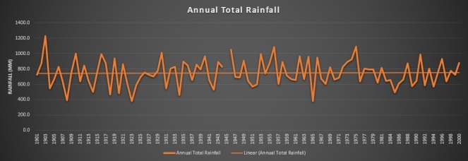
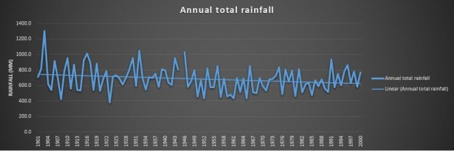
Kolar District, especially was once rich in water tanks and local harvesting measures. Average rainfall in Kolar is 750 mm, which is not low. According to the Karnataka Gazetteer, the district had, in 2012, only 2,095 tanks from the 35,783 tanks in 1968. Most of the tanks were a victim of siltation, encroachment and neglect.[5] Organisations like Gramvikas and Dhan Foundation have demonstrated how desilting and management of tanks in Kolar can secure water for drinking as well as for irrigation, cattle rearing, etc.[6] Some groups have worked on highlighting the positive impact of applying reservoir silt to crops, as an option to fertilisers and to facilitate desilting. Indian Institute of Sciences (IISc) has demonstrated that desilting these tanks in Kolar can not only help water security, but it can also reduce the incidence of fluorosis.[7]
River Rejuvenation: Long distance water diversion is not an answer to drying and dying rivers Rivers like Arkavathy are dying due to persistent pollution from industries and urban areas and also due to catchment degradation. How will waters from Yettinahole revive this situation? Local efforts, sound environmental and water governance however, can help this situation. But this is not being explored sufficiently.
_____________
Long-distance water transfer: problems and prospects
(From: Prof. Asit Bisaws, Long-Distance Water Transfer United Nations University, 1983)
If many of the past and present experiences on long-distance water transfer are reviewed critically, the following major issues emerge:
(1) Mass transfer of water is often justified by considering only the direct cost of transporting water. Seldom are the values of services foregone by the exporting region due to reduction of their water availability, i.e. the opportunity costs of exported water analysed.
(2) Various other feasible alternatives to interbasin water transfer are often not investigated. There is a tendency within the engineering and economic professions to opt for technological solutions-“soft” options tend to be neglected. Since water resources development is dominated by these two professions, there is a tendency to opt for technological fixes before all viable alternatives are explored. Among possible options are:
-more efficient use of available water;
-re-use of waste water;
-better management of watersheds;
-improved integration of surface and groundwater supplies;
-changing cropping patterns.
______________
Climate Change and Western Ghats:
Climate change Assessments like 4X4 Assessment of INCA have indicated that rainfall in southern Western Ghats, which also includes Netravathi and Gundia catchment is expected to fall in the coming years. This will affect water resource projects, crops, fisheries, etc. (https://sandrp.wordpress.com/2013/07/26/climate-change-in-western-ghats-4×4-report-and-beyond/)
We cannot ignore these signals while planning expensive schemes at the cost of ecology and sociology which might prove to be inviable in a few years in face of climate change. Keeping all these factors in mind Karnataka needs to proceed extremely cautiously on Yettinahole diversion scheme.
_______________
VII. In Conclusion
Environment and Social Assessment are basic prerequisites for a project of such massive dimensions.
All in all, looking at several serious issues associated with Yettinahole Diversion Project, it is urgently needed that:
- Project should undergo complete Environment appraisal and Clearance scrutiny, as laid down by the EIA notification, 2006
- Recommendations of the Western Ghats Expert Ecology Panel about avoiding inter-basin transfers in the Western Ghats should be adhered to.
- Options Assessment and cost benefit analysis, including the ecological costs of the diversion should be carried out and put in public domain.
- Downstream affected communities, including cities like Mangalore and estuarine fisher folk should be consulted during public hearings.
- Unbiased assessment about the water stress in Kolar and Chikkaballapur should be carried out with members from groups which have been working from the region, to evolve a holistic water management policy for the region.
- Options for reviving rivers and tanks in Kolar-Chikkaballapur need to be explored using traditional and appropriate technology practices. Appropriate cropping pattern and cropping methods should be a part of this exercise.
- A review of rain water harvesting, efficient water supply, demand management, lake revival, groundwater recharge, grey water and sewage recycling for cities including Bangalore should be carried out prior to allocating more water from distant sources to such cities.
- A democratic bottom up exercise has to be taken up on such proposals both in the Western Ghats areas as well as the projected benefiting areas.
It will not be the interest of the ecology in Western Ghats, Eastern regions or communities in Dakshin Kannada, Hassan, Kolar, Tumkur, Bangalore and Chikkaballpur if a project of such massive proportions, with devastating social and environmental impacts is taken up for short term political or financial gains, bypassing proper credible appraisal and democratic decision making.
Kolar and Chikkaballapur regions have been facing severe water crisis, leading to hardships to local communities. But, for a long term and sustainable solution to these problems, Yettinahole Diversion does not look like a viable option, we do not even know how much water will reach these regions. But the project has the potential to exacerbate ecological degradation, fuel man animal conflicts and further water conflicts between regions.
Drought affected regions may have better options, including better operation and maintenance of existing water infrastructure, more appropriate cropping and water use pattern, revival of existing water harvesting structures, recycle and reuse of water, among others. Attention needs to be paid to these options, rather than ‘diverting’ it.
Hidden costs of projects like Yettinahole Diversion are too big to be actually hidden.
-Parineeta Dandekar, SANDRP (parineeta.dandekar@gmail.com)
[1] Volume II, Part B, Estimates, Section: Estimates for implementation of the scheme: Drawings
[2] Minutes of the Meeting, 63rd EAC Meeting, MoEF held on 12-13th October 2012. Agenda Item 2.11 (B)
[3] Pteridophytes are plants from the fern family that reproduce by spores.
[4] http://www.deccanherald.com/content/264870/researchers-stumble-species-fish.html, Ichthyological Exploration of Freshwaters, Vol. 23, Number 4

How much does the Kasturirangan Committee understand about Water Issues in Western Ghats?
The Ministry of Environment and Forests constituted the Western Ghats Experts Ecology Panel (WGEEP) in March 2010 under the Chairmanship of Prof. Madhav Gadgil. The Panel submitted its report on 31st August 2011. Here on, the report was kept under wraps by the MoEF and only after strict orders from the CIC and High Court was it released to the public in May 2012.
On Aug 17, 2012, MoEF set up the High Level Working Group (HLWG) under the Chairmanship of Dr. K. Kasturirangan to study recommendations of this Report. Members of this Committee include Sunita Narain, Prof. C.R. Babu, J.M. Mauskar, Prof. Kanchan Chopra, Shri Darshan Shankar etc. The HLWG was to look into the recommendations of the WGEEP report and the comments from the various stakeholders. The very constitution of the HLWG raised suspicions that this has been formed to dilute the recommendations of the WGEEP. The functioning of the HLWG left a lot to be desired, it refused to give time to listen to the affected people at many places. On April 17, 2013, after a number of extensions, the HLWG submitted its report.
It seems the HLWG Report (HLWGR) has worked hard to hugely dilute the WGEEP reccomendations. In many cases, HLWG report has made the recommendations of the WGEEP report ineffective. No wonder, Prof. Madhav Gadgil himself has said: “ The initial impression (about HLWG Report) is that there are differences of approach in protecting the ecology of the region. The WGEEP report talks about the facts and we have pointed out that misgovernance is a major issue affecting the ecology of the Western Ghats. This was totally neglected in the new report, which calls for more role for bureaucracy. Providing more power and money to bureaucracy is like giving it to ‘Dusshasana’, and it is a wrong approach” . (http://newindianexpress.com/states/kerala/Kasturirangan-Committee%E2%80%99s-report-favours-bureaucracy-says-Gadgil/2013/04/20/article1553460.ece)
Dilution of WGEEPs strong recommendations is highlighted in the case of 200 MW Gundia Hydel Project in Karnataka and 163 MW Athirappilly Hydel Project in Kerala. While WGEEP Report has categorically rejected these projects based on their severe impacts on ecology and communities, the HLWG has refrained from doing so. The HLWG Report has gone ahead to recommend a few largely irrelevant, measures, while actually giving OK to these projects. Whatever suggestions of review HLWGR has given, the governments would be happy to do the necessary paper work and show that they have done that. The authors of the HLWG report seemed happy to toe the lines that government wants, rather than do justice to the mandate given to them. This was unexpected as both the projects not only have severe impact on ecology, but are also facing stiff and sustained local opposition. The HLWG Report does not seem to give any value or try to understand the reasons behind these local protests.
HLWGR has certified that Athirappilly Project is required for Kerala for peaking power. This is very strange certificate. Do we have an assessment of how much of the power generation from Kerala Hydro projects (incidentally Kerala has one of the highest proportion of installed power capacity under hydro projects, compared to any other state) today is providing peaking power? None. Do we have any credible attempt at ensuring more optimum peaking power generation from existing hydro projects in Kerala? None. Do we have any credible attempt at demand side management in Kerala to manage the peak load requirements? None. Have the KSEB and Kerala government implemented the orders of the Kerala High Court while HC rejected the environmental clearance to the Athirappilly project? No. Then on what basis has the HLWGR certified that “the project’s importance for meeting the peaking power requirements of the State cannot be disputed”?
The other recommendations of the HLWGR about hydropower development in Western Ghats are also problematic. It recommends environmental flows as 30% of lean season flow for hydropower dams, rather than asking for assessment of environment and social requirements of flow in the rivers. These studies cannot be done at a later stage as indicated by the HLWG. It makes no recommendations for flows in other seasons, including monsoon. The HLWG recommends that distance between 2 hydel projects should be minimum 3 kms, again without any basis. It should have asked for site specific studies rather than making such one-size-fits-all kind of recommendation, indicating lack of understanding of environmental issues. It should have at least mentioned ‘distance of free flowing river between two projects should be three kilometre”. Even in case of ROR projects, the submergence itself stretches for kilometres. Cascade hydel dam development which is devastating the Himalayas has not started in Western Ghats. Giving a recommendation like this is in fact inviting more cascades in Western Ghats, that too in the ESA.
The HLWGR has allowed what is it calls Green Growth in the Western Ghats area. But there is no credible process suggested as to who will decide this and how? How will such a process be achieved? Where is the road map to achieve it? The government itself calls all hydropower projects as green growth projects. It is shocking to read that HLWGR also describes all hydropower projects as clean and renewable, exposing their lack of understanding of the hydropower projects and their impacts. The HLWGR seems not bothered by the adverse impacts of such projects on the Western Ghats environment, this is clear in its recommendation agreeing to green growth projects without any credible process.
The HLWG has also not rejected Inter basin transfers from Western Ghats. In doing so, they have quoted justification that “Maharashtra that Rain Shadow Regions” need drinking water. Ironically, all the inter basin transfers happening in Maharashtra (Koyana and six Tata Dams) actually involve transfers FROM the rain shadow region TO water-rich Konkan region for power generation. But the HLWG Report says nothing about this Ulti Ganga. They should have actually recommended stoppage of these diversions if they had the interest of drought prone areas of Maharashtra in mind.
The HLWG Report is also entirely silent on the need to amend the EIA Notification 2006 to include Drinking Water and Industrial Water Supply Dams and Mini Hydel Projects below 25 MW and irrigation projects with command less than 10000 ha under the purview of this Notification. This has been one of the most serious challenges faced by Rivers in Western Ghats right now and the HLWG does not comment on this. It has not commented on dams like Kalu, Shai, Balganga, Lendhi, Gargai, Pinjal, Khargihill which will have a huge impact on Western Ghats ecology and communities. The extent of this damage is evident in the fact that in a recent Forest Clearance granted to Kalu Dam, the Forest Advisory Committee has asked the proponent to follow the recommendations of the Kasturirangan Committee Report. If only the report had made strong and proactive recommendations there was a chance of saving 1000 hectares of forests of Western Ghats
The HLWGR has not commented on fisheries at all.
While a more detailed critical look at the HLWGR will take time, this compilation puts before the readers exact passages from HLWG (see Section A below) and WGEEP (see Section B that comes after Section A) Reports for ready reference. It shows how much understanding of water issues the members of HLWG have or do not have.
– SANDRP
EXCERPTS FROM HLWG AND WGEEP REPORT ON WESTERN GHATS
A. High Level Working Group (HLWG) Report on Western Ghats (Kasturirangan Committee Report)
(HLWG Report Volume I, pp. XII-XXIII)
Out of the estimated 164,280 km2 of the Western-Ghats area, the natural landscape constitutes only 41 per cent. The area identified as ecologically sensitive is about 37 per cent i.e., about 90 % of the natural landscape.
1. Hydropower
Hydropower projects may be allowed in the ESA but subject to following conditions:
(a) Uninterrupted ecological flow at least 30 per cent level of the rivers flow in lean season till a comprehensive study establishes individual baselines.
(b) After a cumulative study which assesses the impact of each project on the flow pattern of the rivers and forest and biodiversity loss.
(c) Ensuring that the minimum distance between projects is maintained at 3 km and that not more than 50 per cent of the river basin is affected at any time.
The villages falling under ESA will be involved in decision making on the future projects. All projects will require prior-informed consent and no objection from the Gram Sabha of the village. The provision for prior informed consent under the Forest Rights Act will also be strictly enforced.
The strategy evolved for the continuation of the Western Ghats Development Programme, in the 12th Plan centres around, besides watershed based development, fragility of the habitat, and development needs of the people i.e. a Watershed + approach – an approach which emphasizes conservation, minimal ecological disturbance, involvement of locals along with sustainable model of economic development and livelihood generation with enhanced allocation.
2. Power/Energy, including hydropower and wind-
(HLWG Report, Volume I, pp. 106-108)
Hydroelectric projects, proposed and planned in the forested regions of the Western Ghats have often come in for opposition. It is clear that as much as the country needs hydroelectric power, which is renewable and clean, but it also needs to balance this requirement with the loss of biodiversity in forests and the need for ecological flow in rivers. Both are essential components and policy must determine that these elements are safeguarded. It is also clear that rivers in India play more than just basic ecological functions. These are lifelines for local livelihood, nutrition and water security. The desire to use the river for generating electricity cannot be at the cost of the value of the river. It is this balance that needs to be maintained. In fact, the potential of hydroelectric power has remained the sole driver for management of the river, particularly in its upper reaches. In the lower reaches, the use of the river for large-scale water diversion projects for irrigation and industrial uses becomes the criterion for development. But these single focus objectives must be enlarged so that the competing – and often the primary needs – can be taken into account at the time of planning and management.
It is also clear that rivers do not know boundaries. Therefore, the conditions for hydropower will be stipulated for the entire Western Ghats and not just for ESA. HLWG recommends that future hydroelectric projects in the ESA and the entire Western Ghats must only be considered on the basis of the following policies:
a. Hydropower development must be based on the acceptance of uninterrupted ecological flow at 30 per cent level of the rivers flow in lean seasons till a comprehensive study establishes individual baselines. The 30 per cent ecological flow is mandated in Western Ghats keeping in mind the shorter length of rivers in this region. The compliance with this condition will require rigorous and seasonal data collection in upper reaches of rivers to prepare a hydrological mapping of the basin. It is also clear that this hydrological assessment is critical given the changes in rainfall patterns because of climate change.
b. Hydropower projects must be considered only after a cumulative impact assessment on the flow pattern of the rivers and forest and biodiversity loss. Currently, individual projects are planned and executed without consideration of these impacts. The Environment Assessment Committees will only consider proposals for individual projects after cumulative impacts have been studied.
c. Current and future hydropower development in the Western Ghats must be based on clear rules that stipulate distance between projects and that do not allow for over-exploitation of the basin. The minimum distance between projects must be maintained at 3 km in most cases (shorter distance requirement because of the short length of the rivers in Western Ghats as compared to other regions) and not more than 50 per cent of the river basin should be affected at any time. This will require reworking the current projects to provide for optimized energy generation but it is necessary given the need to balance development with ecology.
d. Better and more balanced planning for hydropower will lead correct tariff of energy, taking into account the cost of raw material of water. Energy costs, world over, take into account the cost of raw material. It is imperative that the current subsidies and distortions in raw material supply for energy are minimized. It is in this context that water, as the raw material for generation of hydropower, must be factored in the project design. The ecological, social and cultural health of the river is a price that cannot be discounted at the time of planning for the feasibility of power.
e. There is a need to redesign and reevaluate small hydropower projects – below 25 mw as these often have limited impact on energy generation and can lead to huge impacts on ecology. The rationale for small projects must be considered within a policy framework, which provides for mini-grids and local energy distribution.
HLWG about Inter-basin transfers-
(HLWG Volume-I. pp- 100-103)
WGEEP recommendations for sector level planning and their implications
The WGEEP has recommended guidelines for sector-wise activities, which would be permitted in categorized ecologically sensitive area of the region. In this way, regions with the highest ecological sensitivity would have restricted developmental activities – from a total ban on mining to large hydroelectric projects or inter-basin transfer of water and even plantations. The listing is comprehensive and provides an important direction to what will constitute environmentally sound development in this ecologically rich region. The question is how such a development plan will be implemented. Furthermore, it is also important that environmentally sound development should be incentivized and not only practiced through fiat. It is also clear that this recommendation of the WGEEP has evoked the strongest criticism from many quarters. There is apprehension that this ‘blanket prescription’ could be detrimental to economy and livelihoods.
It is also a fact that permit-based regulations are often open for misinterpretation and misuse. A similar issue was raised with the High Level Group on its visit to Maharashtra, when officials explained that there was concern that the WGEEP, if implemented could lead to complete halt of all economic activity. “It would condemn people to live in stone-age”. According to them, the guidelines would not allow for any infrastructure development, from renewable energy to inter-basin transfer of water. This would be a problem, they explained, as many regions of the Western Ghats lie in the rain shadow area and need water to be diverted for irrigation and drinking. Clearly, their concern was the impact of the sweeping nature of the recommendations on the region’s economy. It is not possible to design an effective framework for sustainable development based on such an approach. It is clear that large -scale water diversion projects, which have impacts on the environment and forests, should not be allowed. However, this recommendation should not imply that all water diversion would be stopped even without any study or scrutiny about the individual project or cumulative impact of the projects.
HLWG recommendations for two hydel projects that were categorically rejected by the WGEEP Report
- 163 MW Athirappilly HEP, Kerala:
HLWG is of the view that while the importance of the proposed Athirappilly hydropower project for meeting the peaking power requirements of the State cannot be disputed, there is still uncertainty about ecological flow available in the riverine stretch, which has a dam at a short distance upstream of the proposed project.
It recommends that given the increased variability due to unpredictable monsoon, the project must be revaluated in terms of the generation of energy and whether the plant load factor expected in the project makes it viable against the loss of local populations of some species. Based on this revaluation and collection of data on ecological flow, the Government of Kerala, could take forward the proposal, if it so desires with the Ministry of Environment and Forests.
The HLWG along with the officials of Kerala State Electricity Board and Kerala Forest Department visited the Athirappilly Hydropower Project, after hearing the presentations made by Kerala State Electricity Board (KSEB) and also a local NGO (River Research Centre, Trissur). The team visited the dam site, the settlement of Kadar tribes impacted by the dam, rapids and waterfalls and irrigation dam site. During presentation, the KSEB explained the upstream run of the river hydropower projects – the Sholayar project on the Sholayar river which is tributary of Chalakudy river, the tail water of which is discharged into downstream that flows into Poringalkuthu project which is on the main river itself, the tail water of which is discharged into downstream of Chalakudy river and is used for the proposed Athirappilly project which is about 40 km away from the backwaters of Cochin. All these projects are run of the river projects and there are no dry stretches of the rivers. If these streams/rivers are not dammed, the excess monsoon run off cannot be stored and enters into sea within 48 hours. The average annual inflow, based on 32 years data at Athirappilly, is 1169.Mm3. This is confirmed from the flow data of Chalakudy river at Arangals collected by Central Water Commission. The tail water from Athirappilly will be released into Chalakudy via its tributary at Kannankuzhithodu.
The fluctuations in the water flow in different months and the plant load factor were also explained. The issues relating to Kadar tribal families living close to the submergible portion of the dam were explained to HLWG and it was informed that a package has been worked out for their welfare without rehabilitation as the areas inhabited by them does not come under submergible zone. The NGOs, who met with HLWG, brought to its attention that project would have irreversible impact on the rich biodiversity value of the forest; particularly, along stretch of 7.89 km between dam site and the point where the tail race water joins Chalakudy river. They said that the habitat of the Kadar tribal population would be adversely hit and that people had not yet given their consent. In addition, they said that this project, being built in an area of biodiversity value, would have minimal benefits. The technical feasibility of the project was doubtful with meager amount of power obtained at high cost. In addition, plantation owners and farmer representatives located below the proposed project said it would have adverse impacts on downstream irrigation and drinking water.
The HLWG examined the status of forests, including the riparian forests and submergible slope forest, a small swampy area and the plantations. It is clear that as in all hydropower projects, there is a need to balance the need for energy, particularly peaking power, water supply and irrigation with the loss of biodiversity, forest habitat, displacement of tribal communities and the need for ecological flow in the river.
HLGW, after detailed deliberations on each of the critical issues, is of the view that while the project’s importance for meeting the peaking power requirements of the State cannot be disputed, there is still uncertainty about ecological flow available in the riverine stretch, which has a dam at a short distance upstream of the proposed project. Given the increased variability, in flow from catchments due to unpredictable monsoon rains, the project may be revaluated in terms of the generation of energy and if the plant load factor expected in the project makes it viable against the loss of local populations of some species. Based on this revaluation and collection of data on ecological flow, the Government of Kerala, could take forward the proposal if it so desires with the Ministry of Environment and Forests.
- 200 MW Gundia HEP, Karnataka:
As the proposed Gundya hydropower project is located in the ESA, it must be proceeded upon with extreme caution. HLWG recommends that the Government of Karnataka should reassess the ecological flow in the downstream areas, based on a thorough evaluation of hydrological regimes in the area. The project should not be given the go-ahead, till such a review and reassessment is made. The Government’s review must also assess local damage to all forests, which will emanate from the construction work and if at all, this can be mitigated. The HWLG has not proposed a complete ban on the construction of hydropower projects in the ESA, but its recommended conditions that balance the needs of energy with environment, must be followed.
Background: The Karnataka Power Corporation Limited (KPCL) has proposed a hydroelectric project in the Gundya River basin in the Hassan and Dakshina Kannada district in two phases: Phase I of 1x 200 MW and Phase II of 1x 200 MW. The project is on Gundya river – a tributary of west flowing river of Netravathi; phase I involves pooling of waters by linking Yettinahole, Kerihole, Hongadhalla and Bettakumari and water from these streams will be intercepted by small weirs and will be drawn through a tunnel running from Yettinahole leading to Bettakumari reservoir. From the foreshore of this reservoir, 7.8 km long head trace tunnel takes water to a surge tank and from there to an underground powerhouse. The Phase II will have two tunnels – one tunnel will take water from Kadumanehalla and surrounding areas by 13 km long unlined tunnel and discharge into tunnel that takes water from Yettinahole weir, and another tunnel of 15 km long will take water from Lingath hole and Kumaradhara to Bettakumari reservoir. The submergible area will be 184.64 ha. An additional 560 ha will be needed for infrastructure. KPCL is not going ahead with the Hongadhalla dam because of the extensive submergible area of 523.80 ha. The project has got necessary clearances from different regulatory agencies; EAC of MoEF has asked KPCL to conduct also public hearing in Dakshna Kannada District, as project area falls in both the districts. The public hearing was conducted at Siribagiln village of Puttur taluka on 25.03.2009. Meanwhile the Malenadu Janapara Horata Samithi made a representation before the subcommittee of EAC during its visit to the site on 5.12.2009. The EAC has recommended clearance but the MoEF has not issued the environmental clearance.
The land required for the project includes forest area of 113 ha, revenue land of 263.63 ha, which also includes forests (though mostly degraded); and 71.5 ha of private land making it a total of 448.13 ha. The site has unique forest types with high biodiversity values (endemic, rare, threatened and new species) and also the cardamom and coffee plantations with scattered forest patches, which will be impacted adversely by land use changes and changes in hydrological regimes in the river basin due to project.
The major impacts of the project would be: (i) submergence of patches of riparian forest, (ii) land degradation/fragmentation of forest patches for tunneling and road construction; (iii) the drying up of down streams of three Yellinahole (with 60.50 km2 catchment area), Kerihole (27.00 km2 catchment area), Hongadahalla (8.50 km2 catchment area) and Bettakumari (35.00 km2 catchment area) before they join Gundya river, although each of them has small catchments, and a stretch of 34 km of Gundya river; and (iv) the apprehension of shortage of water at Subramanya Swami temple.
HWLG notes that the Gundya hydel project is run of the river project, which must ensure ecological flow in the affected stretch of the river. Furthermore, while the area of the submergible portion of forest is small, the construction of the project and tunneling in the region will have adverse impacts on both government forests and green areas on private land. As the Gundya hydropower projects is located in the ESA, HLWG recommends that it must be proceeded upon with extreme caution. It would recommend that the Government of Karnataka should reassess the ecological flow in the downstream areas, based on a thorough evaluation of hydrological regimes in the area. The project should not be given the go-ahead, till such a review and reassessment is made. The Government’s review must also assess damage to all forests, which will emanate from the construction work and if at all, this can be mitigated. The HWLG has not proposed a complete ban on the construction of hydropower in the ESA, but its recommended conditions that balance the needs of energy with environment must be followed.
B. WESTERN GHATS EXPERT ECOLOGY PANEL (WGEEP) REPORT
Athirappilly and Gundia Hydel projects
WGEEP Categorically rejects both the projects for their impact on communities and ecosystems.
Sectoral Recommendations relating to Water
Recommendations for ESZ I, II, III-
Decentralized water resources management plans at Local Self Government level Protect high altitude valley swamps and water bodies. Catchment area treatment plans of hydroelectric and major irrigation projects should be taken up to improve their life span. Improve river flows and water quality by scientific riparian management programmes involving community participation Water conservation measures should be adopted through suitable technology up gradation and public awareness programmes inter-basin diversions of rivers in the Western Ghats should not be allowed
Hydropower projects
For ESZ I-
- Allow run of the river schemes with maximum height of 3 m permissible which would serve local energy needs of tribal/ local communities / plantation colonies subject to consent of gram sabha and all clearances from WGEA, SEA and DECs.
- No forest clearance or stream diversion for new projects
- Run of the river schemes not allowed in first order or second order streams
- Promote small scale, micro and pico hydropower systems, that are people owned & managed and are off grid
- New small hydropower projects (10 MW and below) are permissible
For ESZ II-
- Small bandharas permissible for local and tribal community use / local self- government use
- No new dams above 15 m or new thermal plants permissible
- New hydro projects between 10- 25 MW (up to 10 m ht) permissible
- All project categories subject to very strict clearance and compliance conditions through SEA and DECs of WGEA
- Have run off the river hydropower projects but after cumulative impact study of the river basin is done
For ESZ III-
- Large Power plants are allowed subject to strict environmental regulations including 1. Cumulative impact assessment studies 2. Carrying capacity studies 3. Minimum forest clearance (norms to be set by WGEA) 4. Based on assessment of flows required for downstream needs including the ecological needs of the river.
- For already existing dams reservoir operations to be rescheduled for allowing more water downstream
Common recommendations for all the three zones-
- No diversion of streams/ rivers allowed for any power projects and if already existing, to be stopped immediately.
- Catchment area treatment in a phased manner following watershed principles;
- Continuous non-compliance of clearance conditions for three years would entail decommissioning of existing projects
- Dams and thermal projects that have crossed their viable life span (for dams the threshold is 30–50 years) to be decommissioned in phased manner
- All project categories to be jointly operated by LSGs and Power Boards with strict monitoring for compliance under DECs
Fisheries
Recommendations for ESZ I, II, III-
- Strictly control use of dynamite and other explosives to kill fish; provide fish ladders at all reservoirs Introduce incentive payments as ‚conservation service charges‛ for maintenance of indigenous fish species in tanks under control of Biodiversity Management Committees or Fishermen’s co-operatives; monitor and control trade in aquarium fishes with the help of Biodiversity Management Committees
Water use-
(WGEEP Report Volume II, pp. 32-37)
Water resources management in the Western Ghats region is inextricably linked to improving the flows in the rivers and the health of the catchments. Western Ghats is the origin of many of the important Peninsular Rivers like Cauvery, Krishna and Godavari that drain the Deccan Plateau and flow eastwards. The hundreds of shorter perennial monsoon fed west flowing rivers like Sharavati, Netravathi, Periyar, and the Bharathapuzha travel through steeper and more undulating topography before emptying into the Arabian Sea. A rough estimate reveals that 245 million people in the five Western Ghats states directly depend on these rivers for their diverse water needs. Geographically, the Western Ghats is the catchment for river systems that drain almost 40 % of the land area in India. The basin area of west flowing shorter rivers is mostly located on the steep western slopes. Except for a few coastal streams 1/3 rd of the basin area of most of the river basins is located within the Western Ghats. This too makes them fragile and calls for their proper care and management. Once these streams leave the Western Ghats proper, they are drained and enriched by the once fertile steep river valleys, midlands and flood plains. The coastal and backwater fisheries is sustained by the rich nutrients and sediments brought down by the flowing rivers. The musings by fisher folk in coastal Kerala: ‘The Sea begins in the mountains and ‘fertility of the coast and the plains depends on the wealth from the rivers’ holds significance in this context. Open dug wells and springs are the other important water resources being extensively used for irrigation and drinking water purposes in the Western Ghats region. In several places, water–‐ harvesting structures dependent on rainwater are also used. In the Sigur plateau, numerous drinking water schemes dependent on the Moyar River are being operated for the tribal and dalit populations. Bore wells have made their entry in the recent past due to intensive irrigation patterns and lowering of water tables. As for Kerala, the groundwater potential is low when compared to other states and shallow dug wells are the most common source of freshwater. However, over the years the groundwater table is lowering at an alarming rate indicative of poor recharging capacity. On the other hand, water needs for drinking water, energy, irrigation and industrial purposes are growing in the Western Ghats States. More and more water is being diverted even from irrigation dams to meet the thirst of the expanding urban spaces and for industries. We have examples of Siruvani, Kabini, Peechi and Malampuzha reservoirs across the Western Ghats where irrigation water is being diverted for drinking and for the industrial needs of cities in the midlands like Coimbatore, Bangalore and Mysore, Thrissur and Palakkad respectively. New dams are being planned and some of them are in different phases of construction in the Maharashtra Western Ghats to meet the expanding needs of Mumbai and its suburbs. Pinjal, Shai, Gargai, Kalu and Vaitarani dams are recent cases. Water abstraction through check dams across hill streams is being practiced for decades by tea and coffee plantations in upstream catchments of rivers to meet their drinking and irrigation needs. This has resulted in cutting off the stream flows at their origin itself. Indiscriminate and unplanned tourism is another reason for increasing water abstraction and diversion. The tourism industry in Ooty depends on the reservoirs constructed across the tributaries of the Cauvery in the high mountains since the times of the British. Studies reveal that east–‐ flowing Rivers like Krishna, Cauvery are struggling to reach the seas due to over abstraction of both surface and groundwater. Basins are closing and its impact is felt even on delta fishing, farming livelihoods and ecology. During the 2001-2004 drought years, the discharge from the Krishna to the ocean was almost nil! As for the west-flowing rivers, saline ingress is advancing even into the midlands due to reduced downstream flows. Crop losses and saline water intrusion into drinking water has been reported in Kerala during severe summer owing to salinity intrusion. In Goa, mining has affected groundwater and surface flows and drainage patterns of rivers impacting downstream needs and water quality. Tailings from mines are polluting streams and rivers. The Kudremukh mining issue is a classic case of mining- related pollution. This mountain range has a long history of human interventions and each of these have directly or indirectly impacted upon the water resources availability and recharge in the region. Some of the important interventions and issues that have had lasting impacts on water resources and its management in the Western Ghats are briefly discussed below.
Issues of Concern
Forest destruction in the river catchments
Western Ghats has a long history of deforestation. Deforestation of upper catchments of rivers for timber, river valley projects and plantations has drastically reduced the capacity of the hill streams that feed into the rivers to hold and recharge water. Drying up of streams immediately after the monsoons and desiccation related to deforestation is clearly evident. This in turn has contributed to reduced summer flows.
River management in the Western Ghats
Most of the rivers in the Western Ghats are either dammed or diverted, some of them at several sites for power generation in the upper reaches and irrigation in the lower reaches. For instance, the east–‐‑flowing tributaries of Cauvery (Bhavani, Moyar, Kabani) and Krishna (Bhima, Tunga, Bhadra) are already dammed. The west–‐‑flowing shorter rivers (Sharavathi, Periyar) have been dammed at several places. We also have complete diversion of river flows at Mullaperiyar and Parambikulam dams involving Kerala and Tamil Nadu. West-flowing rivers have been virtually made into east–‐‑flowing Rivers by violating all natural laws. Dams are without dispute the most direct modifiers of river flows. They can heavily modify the magnitude (amount) of water flowing downstream, change the timing, frequency and duration of high and low flows and alter the natural rates at which rivers rise and fall during runoff events. Severe daily flow fluctuation between peak and off peak times below dams is commonplace in west–‐‑flowing dammed rivers. This has impacted drinking water schemes, major and minor irrigation projects operating in downstream areas apart from cutting off flood plains and impacting aquatic ecology and riparian systems. However very few studies are available that correlate the reservoir operations with the different types of downstream impacts and put measures in place for mitigation. In the case of inter-basin water, no water flows or even
The Mullaperiyar dam is a classic case where the main tributary of Periyar has been completed diverted to the Vaigai basin in the east. Idukki dam does not even have a spillway for allowing monsoon spills into the river. In Maharashtra, the tail race discharges of Koyna Powerhouse I, II and III are released into the west–‐‑flowing Vashishthi River and lead to heavy floods in Chiplun. Continuous stretches of rivers have dried up irreparably below diversions affecting river ecology, surface flows and even ground water seepage. Many of the reservoirs especially in the steep valleys are silting up prematurely due to the massive encroachment and deforestation of catchments consequent to dam construction. Idukki dam is a classic case wherein the entire catchment was encroached along with dam construction. The operations of hydroelectric stations (reservoir operations) are in tune with the power needs rather than the downstream water needs. Hence daily flow fluctuations created by peak and off peak operations of reservoirs in dammed rivers have led to upstream- downstream conflicts in many river basins. Similarly diversion of flows into another river basin after power generation is creating problems of daily flood in the recipient basin and drought in diverted basins. These are turning into management issues which need to be addressed at a basin level. However, there is a lack of systematic river basin level data on ecological changes due to hydrological alterations created by dams.
Incorrect land use patterns
Mining for mineral ores, granite and lateritic mining has affected water availability and recharge especially in the lower altitude regions and midlands. In Goa alone, the government itself has acknowledged that over half of the 300 odd mining leases are located close to water bodies. Data tabled in the Goa Assembly revealed that several of the 182 mining leases exist within one kilometer of a major irrigation project, the Selaulim dam, which provides drinking water to six lakh people in south Goa, virtually half the population of Goa (Ref: Deccan Herald Article).
In South Karnataka and North Kerala, surangams, a traditional irrigation system in lateritic hills is losing out to lateritic mining. Many of the rivers in this region originate from these lateritic hills and many of the Western Ghats Rivers like Chandragiri, Valapattanam, and Netravathi benefit from the water recharged by lateritic hills in their flow downstream.
Agricultural practices including cropping patterns have a role to play in water resource management in the Western Ghats. Planting steep slopes with soil–‐‑eroding monocu;ture crops like rubber and banana, and heavy tillage, has led to increased surface runoff along with loss of precious top soil. This has contributed to low seepage and infiltration into deeper soil depths. The deforestation for tea, coffee and cardamom plantations located at higher altitudes has contributed to drying up of hill streams.
Reclamation of high altitude valley swamps is contributing to water scarcity in the upper catchments. Many of the rivers originate from these swamps and are source of perennial flow. In the Nilgiris, most of the fertile water rich swamps have been converted for intensive pesticide-based farming, greenhouse farms, housing, etc.
Sand mining
Most of the rivers in Western Ghats are facing the consequences of indiscriminate sand mining. The lowering of water tables and deterioration of water quality are the immediate impacts. River beds in some stretches are lower than the sea level accelerating saline ingress. Drinking water scarcity is on the rise in river bank panchayats in spite of being close to the river. Plan funds are spent for providing drinking water even to panchayats on river banks. Sand mining has also impacted breeding and feeding grounds of fish and other aquatic species
Measures for Mitigation/Improvement
Time for river basin-level planning and decentralised management of water resources in the Western Ghats As cited above, the impacts of incorrect land use and interventions are already evident. Reduced summer flows, flow fluctuations, lowering of water tables and degrading water quality are all direct impacts of the presently followed project–‐‑oriented, demand-supply based and ad hoc approach to water resource planning and management. The time is ripe for a paradigm shift in approach to river basin–‐‑level management of water resources where water is considered an integral part of the ecosystem. Some important measures that can be adopted in this regard are briefly detailed.
1. Local self–‐‑ government level decentralized water management plans to be developed at least for the next 20 years: Water resource management plans with suitable watershed measures, afforestation, eco–‐‑restoration of catchments, rainwater recharging and harvesting, storm water drainage, water auditing, recycling and reuse etc. should be built into the plans. These water management plans should integrate into basin level management plans. The objective is to reduce the dependence on rivers and external sources and to improve recharge.
2. Reschedule reservoir operations in dammed rivers and regulate flows in rivers to improve downstream flows and also to act as a conflict resolution strategy. These should be implemented with an effective public monitoring system in place.
3. Revive traditional water harvesting systems like recharge wells, surangams, etc.
4. Protect high altitude valley swamps that are the origins of rivers from further reclamation and real estate or agricultural development and declare them as ‘hotspots for community conservation’
5. Participatory sand auditing and strict regulations to be put in place.
6. Declare “sand holidays’ based on assessments and sand audits for mined river stretches. Items 5 and 6 would work to improve the water retention capacity in the river.
7. Rehabilitation of mined areas to be taken up by the companies / agencies with special focus on reviving the water resources like rivers, wells, tanks, etc. that have been destroyed by the mines.
8. Planters, local self–‐‑governments and Forest Departments in high altitude areas should come together for eco–‐‑restoration of the forest fragments between the tea and coffee estates and revive hill streams.
9. Take up catchment area treatment plans of hydro and major irrigation projects to improve their life span.
10. Riparian management can be taken up with community participation and involvement to improve river flows and water quality.
11. Water conservation measures should be adopted through suitable technology upgradation and public awareness programs.
12. Reconnect children and youth to rivers and water resources through basin level education programs.
Actionable points for the WGEA-
The (proposed) Western Ghats Ecology Authority (WGEA) can take a strong recommendatory and advisory role in this regard. Some of the important recommendations for WGEA are:
1. Declare origins of rivers as Ecologically Sensitive Localities (ESLs) (the catchment area)
2. Many projects in the Western Ghats are on–‐‑going or completed with violations in environmental clearance and forest clearance or even no clearances at all, as in the case of the Kalu and Shai dams in Maharashtra. The WGEA should act as an additional layer for screening projects approved by the Expert Appraisal Committees (EACs), subject them to additional scrutiny in terms of the geographical context, ecological sensitivity, status of river basin and need for environmental flows taking into consideration all season flows instead of ad hoc allocations.
3. Till the WGEA comes into operation, issue a moratorium on all on–‐‑going projects like dams and mines that can impact upon water resources in a substantial way. The WGEA should subject the projects to scrutiny for mandatory clearances and compliances, and augment the level of public consultation before deciding on whether to allow them to progress or not.
4. No more inter–‐‑basin diversions of rivers shall be allowed in the Western Ghats.
5. Take up sample river basins in each state and recommend to the State Governments to carry out:
- Environment flow assessments involving social movements for river protection, research institutions, NGOs along with communities to put in place indicators for environmental flow assessment
- Assessment of downstream impacts of dams on river ecology, flood plains, fishing habitats, livelihoods, etc.
- Salinity intrusion mapping so as to suggest improved flows in future
- Improve reservoir operations management in dammed rivers to improve meeting of water needs of downstream populations. Put proper monitoring of reservoir operations in place involving downstream local self–‐‑governments and departments.
- Update and upgrade hydrological databases in rivers and consolidate the ecological database and information at river basin level
- Based on the consolidation of databases, declare high conservation value stretches of rivers as ESAs and keep them free them from further development.
6. Recommend to State Governments to take up decentralized bottomup river basin planning with restoration built into the plans.
7. River Basin Planning should be supported by suitable legal institutions that are capable of integrating different departments which are presently dealing with or impacting on the rivers in a compartmentalized manner. Put in place river basin organizations adapted to state administrative context.
8. All new projects in the Western Ghats (dams, mines, tourism, housing, etc. that impact upon water resources) should be subject to cumulative impact assessment and should not exceed the carrying capacity.
9. Stronger and stricter laws for regulation of sand mining to be developed
10. Recommend the decommissioning of dams that have outlived their utility, are underperforming, and have silted up beyond acceptable standards, etc.
Fisheries
(WGEEP, Volume II, pp. 48-49)
Depletion of the fishery resources is a serious issue in the Western Ghats region. Compared to marine fish resources / biodiversity, the freshwater fish diversity is on the decline due to various reasons. Traditionally the conservation and management of fishery resources were vested with local communities, but this has now been altered. Several innovative measures are required to revive this highly valued resource and to use it in a sustainable manner on account of its relevance in livelihood improvement and food security. There is a need to readdress these issues with the fisheries department and other impacting sectors to reorient conservation measures in a participatory mode. Furthermore, local fish consumption has been a traditional source of protein for local people from time immemorial.
Issues of Concern
- Habitat loss, including loss of mangroves
- Pollution due to pesticides, industrial effluents/other sources
- Waste dumping in rivers
- Improper river maintenance and management
- Unscientific methods of collection (use of poisons, electro–‐‑fishing, dynamiting etc.)
- Impoundments in rivers, check dams
- Introduction of exotic fishes
- Destruction/loss of breeding grounds
- Fish diseases
- Overexploitation
- Unauthorised ornamental fish trade
- Sand mining
- Excessive tourism activities in freshwater lakes
- Decline of indigenous species due to introduction of exotic and alien fishes species
Measures for Mitigation/Improvement-
- Regular monitoring of fish wealth to assess the health/ diversity of the fish population.
- Banning the use of plastics which settle at the bottom of water bodies and lakes and affect breeding of some species.
- Management measures aimed at conserving freshwater fish biodiversity to be incorporated into the fishery policy.
- The database on population size and geographical distribution of endangered and endemic species should be strengthened by undertaking extensive micro–‐‑geographical surveys. Information on area of distribution and micro–‐‑geographical characteristics of the habitats of these ecologically sensitive fishes will be inputs for establishment of aquatic reserves for the conservation of these species.
- Information regarding migration, breeding behavior and spawning grounds of threatened fishes should be generated through extensive surveys and analysis. Such a database is essential for both ex situ and in situ conservation of the species.
- Techniques should be developed for the captive breeding and brood stock development of fishes of potential economic importance.
- Brood stock maintenance centers and hatcheries should be established exclusively for indigenous, endangered and critically endangered fishes for their in situ conservation and aqua ranching as a substitute for their natural recruitment.
- Investigation on the invasive nature of exotic species in the natural habitats should be carried out. The functioning of the committee constituted under the Government of India to quarantine and control introduction of exotic species should be made more effective and foolproof.
- Strict vigilance and monitoring, including enforcement of laws, to be ensured to reduce the loss of the natural breeding grounds of the fishes arising from reclamation of paddy and wetlands.
- Strengthen awareness programs to ensure the sustainability and survival of fish resources.
- Regulation on fishing, during breeding seasons in freshwater environs to restore natural/ wild stock
- Establishment of fish sanctuaries
- Sand mining and other activities which destroy the habitat of many endemic fishes to be restricted.
- Live–‐‑fencing using native plant species instead of stone walls to be encouraged for protecting river banks.
- River Management Funds to be utilised for activities related to river health programs and not for construction or other developmental activities.
- Regulation of ornamental fish collection from the wild.
Compiled by Damodar Pujari, SANDRP (damodar.sandrp@gmail.com)
