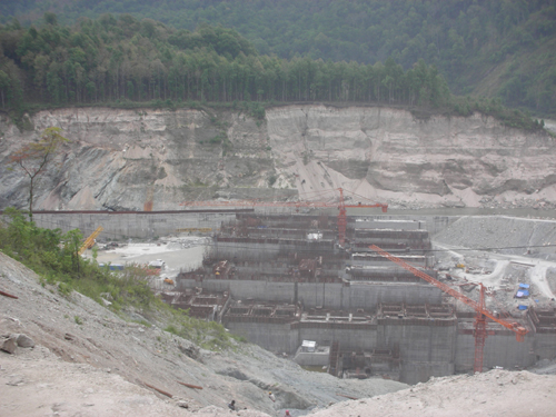
Pic: 1Erosion in Rohmoria in the Upstream of Dibrugarh. Source: The Assam Tribune
The National Disaster Management Authority (NDMA) has recently published a report named “Study of Brahmaputra River Erosion and Its Control”. NDMA had commissioned this study to the Department of Water Resources Development and Management of IIT Roorkee. NDMA is an apex body constituted under the Disaster Management Act, 2005 to prepare the country to face natural and human-made disasters. NDMA is headed by the Prime Minster of India. Under the natural disasters category it includes earthquake, flood, tsunami, land slide and avalanches while nuclear, chemical or biological disasters have been categorized as human-made disasters. This report provides a lot of information and data on the Brahmaputra and its tributaries. The information about erosion is also very much detailed and descriptive. The report can be found at http://ndma.gov.in/ndma/latestdisasterupdates/NDMA%20Final%20Report%20Brahmaputra%20River.pdf
Pic: 2 Recent News Reports of Erosion in Subansiri River, One of the Largest Tributaries of Brahmaputra on the North Bank. Source: Dainik Janambhumi
Pic: 3 Houses on the side of the Old Embankment in Matmora. Source: Parag Jyoti Saikia
This reports deals with a very serious issue of erosion in the Brahmaputra river basin in Assam. Erosion should not be confused with floods even though both are annual phenomena in the Brahmaputra river basin. Erosion can be seen to have a more severe impact than floods because erosion leads to permanent loss of land and property. During floods land and houses are submerged for a period of time. But erosion displaces people from their land and property for good. Erosion inflicts severe damage to agriculture, economy and cultural relations of people. Erosion compels people to migrate to different places. Villages get eroded one after another and people living in those villages have to move to another location with their belongings. But this may not be possible and affordable for all those who lost their land in erosion. So for many of them, living on the side of embankments in very poor living conditions remains as the only option. Erosion also leads to migration of rural youths to urban areas in search of jobs. In the last few decades erosion has posed as a greater threat to the people of Assam than floods. The severity of erosion can be seen from the Table 7 of the report in which Satellite Based Estimation and Comparison of Area Eroded In Brahmaputra during the Period 1990 to 2007-08 and 1997 to 2007-08 have been presented.
Map of the Study Area from the Report
The study divides the river length into twelve segments from Dhubri to Dibrugarh and that is why there are 12 reaches mentioned in the table. It is clear from this table that the while the erosion prone length of the river is 10% higher along the South Bank of Brahmaputra compared to the same along North Bank. Areas facing erosion is 123% higher in South bank during the last decade (1998-2008) of the study period. The highest erosion area/per km of erosion prone bank is upstream of Dibrugarh, where the river enters the plains from the hills.
Areawise division into 12 reaches in the river
North Bank
South Bank
Total Erosion Length
(in km)
1990 to 2007 – 08 (in sq. km)
1997 to 2007-08 (in sq. km)
Total Erosion Length
(in km)
1990 to 2007 – 08 (in sq. km)
1997 to 2007-08 (in sq. km)
1. Dhubri
40.19
124.461
94.129
7.05
194.983
10.791
2. Goalpara
39.5
79.046
40.902
4.85
17.816
5.052
3. Palasbari
54.87
48.668
42.914
14.02
23.006
15.859
4. Guwahati
21.02
7.92
1.654
24.38
5.385
12.079
5. Morigaon – Mangaldai
6
35.606
2.138
47.91
96.979
103.7
6. Morigaon – Dihing
24.86
29.057
7.275
47.8
10.795
56.72
7. Tezpur
8.58
38.758
4.733
52.95
16.628
44.774
8. Tezpur-Gohpur
8.85
31.187
5.794
44.16
26.098
71.227
9. Majuli-Bessamora
24.69
25.562
12.327
47.17
32.788
28.998
10. Majuli Sibsagar
16.93
60.657
16.878
54.95
44.018
42.118
11. Dibrugarh
37.86
37.506
43.529
43.89
46.595
6.066
12. U/s Dibrugarh
70.5
20.376
55.454
57.54
399.529
333.416
Total
353.85
538.805
327.726
389.13
914.62
730.8
The Study Report:There have been a lot of studies done on the river, to find a solution to the issue. But what comes as a surprise is the attempt to shy away with some of the crucial issues of the riverine eco-system in the northeast. But before going into crucial issues, a brief note about the report is provided.
The March 2012 study is divided into two phases. The first phase is named as ‘Sattelite Data Based Assessment of Stream Bank Erosion of Main Stem Brahmaputra and Its Major Tributaries’. In the second phase processing and analysis of the hydrological data of the Brahmaputra and its tributaries has been done.
In the first phase of the study information and data of 18 years (1990 to 2008) has been put together. The study pertains to a reach of 620 km on the main stem of Brahmaputra River, i.e., its entire course in Assam from upstream of Dibrugarh up to the town Dhubri near Bangladesh border. 23 major tributaries (13 northern and 10 southern) within India have also been considered. The data for this whole area was collected using an integrated mechanism of Remote Sensing and Geographical Information System.
In the second phase of the study a new method of analysis called Artificial Neural Networks (ANNs) has been used. The data processed through this analysis has been used for modeling the rainfall-runoff process and runoff-sediment process for the study area.
The report identifies inherent ‘sediment overloading’ of the river fluvial system as the main cause for river bank erosion vis-à-vis channel instability in Brahmaputra. The report recommends by proposing river training works for two pilot areas on Brahmaputra River. The first site is in Bhuragaon of Morigaon district and second one is near the Guwahati airport.
Critical issues:
The team of investigators for this study was led by Prof Nayan Sharma of the Department of Water Resources Development and Management at IIT Roorkee. This is a very descriptive report from the point of information and data about the river Brahmaputra and its tributaries. But even then there are several things that the report does not mention at all.
The report mentioned that inherent ‘sediment overloading’ as the prime cause for erosion in the river Brahmaputra. But another study named “River Bank Erosion and Restoration in the Brahmaputra River in India” has identified several other factors responsible for bank erosion.[1] That study states “The salient hydraulic and bank material factors responsible for bank erosion of the Brahmaputra system are i) rate of rise and fall of river water level, ii) number and position of major channel active during flood stage, iii) angle at which the thalweg approaches the bank line, iv) amount of scour and deposition that occurs during flood, v) variability of cohesive soil in bank material composition, vi) formation and movement of large bed forms, vii) intensity of bank slumping, and viii) progression of abandoned river courses to present-day channel.”
Identifying only ‘sediment overloading’ as the main reason for a dynamic river system like Brahmaputra seems an over simplification that overlooks the critical issues.
Pic: 4 A view of the Balijan Tea Estate Eroded by the Brahmaputra in Rohmoria in Dibrugarh district of Assam. Source: The Hindu
Even though the report identifies sediment overload as the prime cause of erosion, it has provided insufficient analysis as to why the sediment load is actually increasing in Brahmaputra. The report rightly states “Accelerated erosion has occurred in this region due to intensive deforestation, large – scale road construction, mining and cultivation on steep slopes.”
Pro Hydro Bias:Here the report completely ignores case of hydropower development in Arunachal Pradesh and its impact on Brahmaputra and its tributaries. The report nowhere mentions about the proposals for 168 hydroelectric dams in Arunachal Pradesh and its impact in the rivers in Assam. In the recent times, the state has witnessed mass protest against hydropower development in Arunachal Pradesh. In fact the report shows a pro-hydro bias when it laments that “less than 5% of the existing hydropower potential” have been put to use so far. At a time when people are demanding for cumulative impact assessment of dams on the rivers of Assam, reports like this attempt to create confusion among people. It is to be noted that when Assam was witnessing the mass protest against big dams, it was Dr. Nayan Sharma who appeared in the electronic media advocating for big dams.
Pic: 5 Erosion protection work at Nimatighat on the Brahmaputra in Jorhat District on May 5th 2013. Source: http://www.prokerala.com[2]
Bias for Structural Intervention: This report advocates for structural intervention for flood protection and reiterates the need for more embankments. Lots of analysis has been done on the ill effects and poor performance of embankments. Embankments essentially transfer the problems to the downstream. There are ample examples of how structural interventions made for erosion protection have failed. We can take the example of Rohmoria, located in the upstream of Dibrugarh town in this regard. There were a series of structural interventions made to control erosion but it failed.[3]
The embankments proposed in this report for the two pilot-study areas are proposed to be constructed using geo synthetic bags. The geo-synthetic bags will be put inside polymer rope gabions[4] and installed in the critical toe of the bank line. The efficacy of controlling erosion through geo-tube embankments still not established, but even then geo-tubes have become the buzz-word for flood protection in Assam. The Asian Development Bank has offered a loan of $12 million for erosion protection through construction of geo-tube embankments. But Assam government engineers working on Brahmaputra and its tributaries are critical of ADB’s programme of erosion control through geo-tube. In a report published in regional news paper on March 2010, it was stated that revetments like geo-bags cannot be successful in Brahmaputra because it creates a permanent deep channel along the existing river bank.[5] The report also stated that geo-synthetic bags which were installed for bank protection in Palashbari-Gumi area were washed away by Brahmaputra. This area is in the downstream of Saraighat Bridge and close to Guwahati airport area where one of the pilot projects has been proposed.
Impact of Structural Interventions Ignored:The report provides structural solution for erosion control but ignores erosions which were a result of structural interventions in the river. Studies on Brahmaputra basin have shown that during and after the construction of bridges in the river Brahmputra erosion and floods have increased in the downstream areas.[6] In the case of Saraighat Bridge, unprecedented flood and erosion was witnessed in Palasbari and Gumi area. Morigaona and Nagaon districts suffered the same after the construction of Koliabhomora Bridge. Construction of Naranarayan Setu, led to flood and erosion in Dakshin Salmara, Pancharatna and Mancachar.
Similar fears have been expressed for the fourth bridge on Brahmaputra which is under construction between Bogibeel of Dibrugarh district and Kareng Chapori of Dhemaji district. The river is nearly 9 km wide at this point. But for the construction of this bridge, the river had been shrunk to almost 5 km through the boulder spurs. This is posing a great threat of flood and erosion for the downstream areas which include famous river island Majuli and Matmora, where India’s first geo-tube embankment was constructed. Engineers who are involved in the construction of the dykes of the fourth bridge had been reported saying that Matmora area would come under severe threat due to the increased river pressure in the area. The report completely ignores all these facts and shows ‘sediment overloading’ as the cause of erosion.
Besides, the study gives a feeling that erosion in the river Brahmaputra operates in ceteris paribus[7]. The report made no mention about climate change and how it is going to impact a river like Brahmaputra which is flowing right from the Himalayan mountain range. At a time when impacts of climate change are taken into account for every possible environment related matters, ignoring this is another major lacuna of this report.
These critical lacunas put a question mark over the usefulness of the otherwise informative study. Credibility of IIT Roorkee reports have been questioned in the past too.[8] NDMA may keep this in mind and focus on more basic issues. For starters as monsoon sets in and rounds of floods start along Brahmaputra, NDMA’s flood forecasting links have stopped functioning for five days as we publish this in the 1st week of June 2013.
Parag Jyoti Saikia
South Asia Network on Dams, Rivers & People (www.sandrp.in)
[4] Gabions are sausages made of Polymer ropes that are appropriately woven by a special process to fabricate the Gabions in various sizes. Gabions are generally available in a prefabricated collapsible form. Images of polymer rope gabions can be found here – http://www.garwareropes.com/polymer_rope_pro_g.htm
[6] Mahanta, C; Mahanta, A., ‘Bridge over The Brahmaputra’ Economic and Political Weekly, pp 579-581, 2006
[7] Ceteris paribus is a Latin phrase which can be literally translated as “holding other things constant” and usually rendered in English as “all other things being equal”
The following submission has been sent to the Expert Appraisal Committee, River Valley and Hydro Power Projects, Ministry of Environment and Forests, India. The current norms recommended by EAC while clearing hydropower and irrigation projects are hardly leaving any water for the rivers (eflows), thereby destroying rivers as well as livelihoods.
Norms on e-flows followed by EAC need to change
Respected Chairperson and members,
As you know, the Inter ministerial Group on Ganga Basin was constituted by the Union Ministry of Environment and Forests through an order issued on June 15, 2012. It has subsequently submitted its report to the MoEF in April 2013.
While there are several issues about IMG’s report and recommendations, some of the recommendations are the minimum, urgent stop gap measures that need to be implemented by the EAC. IMG’s recommendations are relevant for nearly all rivers across the country. All of the rivers have rich social and religious values and a large proportion of population depends on them for livelihood. Hence, the recommendations of IMG logically apply to all the rivers. In line with the IMG Report recommendations, we urge the EAC to modify its recommendations about eflows and environmental impacts as suggested below:
1. Eflows
a. Eflows to be based on daily uninterrupted flows, not seasonal flows
The IMG report states that: “An important component of the e-flows regime has to be mimicking of the river flows so as to keep it very close to the natural flows. Cumulative norms even on seasonal basis do not meet this objective. Daily inflow norms may, however, enable a sustained river flow as well as have large flows in the high season and hence are more suitable.” (emphasis added)
IMG has thus recommended that all dams and hydro projects should release water based on daily inflows, following the % releases recommended in each season, but the releases must change as per daily inflows.
b. Eflows as 30-50% of daily lean season flows
The IMG report recommends that releases should be 50% of lean season flows where average lean season flow is less than 10% of the average high season flow. Where average lean season flow is 10-15% of the average high season flows, the releases should be 40% of inflows and where 30% for the rest of the rivers.
In keeping with IMG recommendations, we urge that the EAC should be recommending 50% average daily flows in lean season as eflows.
c. Independent, community-based monitoring of Eflows releases
Monitoring of eflows releases from operating projects is crucial, given the fact that it is currently entirely in the hands of the proponent without any monitoring of compliance by the MoEF. In such a situation, proponents are not releasing any eflows as pointed out by the one person Avay Shukla Committee Report, recent CAG report of Himachal Pradesh.
IMG recommends: The IMG has considered the need for an effective implementation of the e-flows as cardinal to its recommendations. It is recommended that the power developer must be responsible for developing a monitoring system which is IT-based and gives on a real time basis the flow of water in the river, both at the inflow and in the outflow after the river gates in the river stream. This should be
(a) monitored by an independent group
(b) reviewed yearly by the Ministry of Environment and Forests in the first five years and
(c) put in public domain the e-flows. This real time public monitoring of e-flows will be the key.
We urge that that EAC recommends similar monitoring norms for all projects. Effective monitoring cannot be done if local affected population is not a part of this process, hence, in addition to above points, EAC should recommend that eflows should be monitored by an independent group which has at least 50% participation of downstream communities facing the impacts of these projects.
d. Assessing eflows only through participatory and true Building block Methodology (BBM)
The IMG states: “Considering environment, societal, religious needs of the community and also taking into taken in to account the status of river Ganga as national river, the IMG recommends adoption of Building Block Methodology (BBM) for assessing the e-flow requirements on a long-term basis. This recognizes the fact that the riverine species are reliant on basic elements (Building Block) of the flow regime, including low flows, and floods that maintain the sediment dynamics and geo-morphological structure. It also includes an understanding of the functional links between hydrology and ecology of the river systems.”
However, the EAC is accepting any eflows assessment as BBM, simply looking at the label provided by EIA consultants, without applying its mind. We have pointed out that BBM purportedly used by consultants like WAPCOS in Lohit Basin Study is not BBM in any sense.
We urge the EAC to:
· Recommend methodology of BBM assessment clearly at the time of granting TORs (This is available from WWF or here: King, J.M., Tharme, R.E., and de Villers, MS. (eds.) (2000). Environmental flow assessments for rivers: manual for the Building Block Methodology. Water Resources Commission Report TT 131/100, Pretoria, South Africa. ),
· Recommend sectors which should be included in BBM study of a specific river (downstream users, fishermen, geomorphology experts, ecologists, etc.) clearly at the time of granting TOR. Downstream users should form a part of the BBM Group in all circumstances.
· Check whether these sectors are duly represented in flows studies
And only then accept the study as being based on BBM methodology. The current practice of EAC of accepting any shoddy assessment as BBM is serving neither the rivers, nor the communities, nor is it expanding India’s experience with BBM.
e. Release of Eflows
It is not just how much the releases are, but how the releases are made that decides if the releases are useful for the rivers, biodiveristy and the society. Unfortunately, EAC has given no attention to this issue.
In this context, one of the guideline of the IMG says, “Fish passes may be made an integral part of hydropower projects. Regular monitoring for their effectiveness be done by project developers.”
EAC should follow this and make well designed eflow release mechanism mandatory part of the EIA study and post-construction monitoring.
2. Free flowing river stretch between projects
Currently, the EAC has a very lax norm of recommending 1 km distance of the river between two projects. In many cases, the EAC is not following even this minimalist distance criterion. Nor is it following recommendations of civil society, or expert committees of having minimum 5 kms of free flowing river before it meets the downstream project/submergence.
In this regard, the IMG notes “There is a clear need to ensure that adequate river length is available to meet the societal needs and River gets adequate time during its flow to regenerate itself.”
The EAC should include, as part of EIA and TOR a detailed study of:
· “Time” required by the river between two projects to rejuvenate itself and how much distance the river need to have such time to rejuvenate itself.
· Ecology (including livelihood fisheries) downstream of a project and how it will be affected by modified flows while granting TORs to hydro projects.
· Social and cultural use of the river downstream the project: presence of religious sites, river sanctuaries, etc. while granting TORs to hydro projects.
Based on this, the EAC should recommend distance of free flowing river that needs to be maintained downstream a specific project. This should be applicable even if this was not stated at the time of deciding TOR.
3. Recommend Free flowing and Pristine rivers in all basins
World over, there exist norms and laws to protect free flowing rivers as “Pristine, Wild or Heritage Rivers”. EAC has been recommending damming most of the rivers in the country in the recent years. The EAC should recommend that some rivers should be maintained in their pristine, undammed (or with the current stage of development, no further) condition.
In fact, the IMG has specifically recommended: “ The River Ganga has over a period of years suffered environmental degradation due to various factors. It will be important to maintain pristine river in some river segments of Alaknanda and Bhagirathi. It accordingly recommends that six rivers, including Nayar, Bal Ganga, Rishi Ganga, AssiGanga, Dhauli Ganga (upper reaches), Birahi Ganga and Bhyunder Ganga, should be kept in pristine form and developments along with measures for environment up gradation should be taken up.”
Unfortunately, currently the EAC is actually clearing projects when Cumulative Impact Studies or Basin Studies on such rivers are not completed or are on-going (Example: Chenab Basin Projects, Satluj Basin Projects, Lohit Basin Projects). We have pointed this out to the EAC on number of occasions, without any response.
We urge the EAC to recommend a few ecologically and socially important rivers in each basin as pristine rivers, to be protected from any projects at the time of clearing basin studies or cumulative impact assessment studies. At the same time, the EAC should analyse the present development stage of a basin while clearing specific projects and should recommend some rivers in pristine state. In places like North East India and western Ghats, certain river basins may need to be left in pristine state.
4. Recommendations to the MoEF about eflows from existing projects
The IMG has made a clear recommendation in this regard: “The suggested e-flows should be applicable to the existing power projects in operation in these States.” IMG has given maximum of three years for the projects to achieve e-flows.
We urge the EAC to make a recommendation to the MoEF to look at existing projects and recommend eflows norms on the same lines as those for new projects in time bound manner.
As the World Environment Day is drawing close, we are sure that the EAC will look at its role of protecting the Riverine environment and communities and will take proactive steps in this regard.
Looking forward to your point-wise response to the issues raised above.
Summary A month after its submission to the Union Ministry of Environment and Forests, the Inter Ministerial Group on Upper Ganga basin Hydropower projects and Ganga river in general is yet to be put in public domain. A detailed perusal of the report shows that the report is hugely biased in favour of large hydropower projects, and has not done justice to the task given to it or to the Ganga river, people or environment. Out of the three non government members (out of total 15 members) on the Group, Dr Veer Bhadra Mishra expired during the working of the group. Rajendra Singh has given a dissent note, not agreeing with the report in its totality. The “alternative view” note from Sunita Narain, the third non-government member, is not much of an alternative and is not in the interest of the river, people or the environment. However, the fact that none of the non-government members have endorsed the report speaks volumes about the credibility of the report.
The recommendations of the IMG report are an exercise largely in supporting the interests of hydropower lobby in the name of balancing the power & development needs of the region and local people. The IMG has actually attempted to make 69 large hydropower projects in the Upper Ganga basin a fait accomplice when only 17 of them are under operation and 14 are under construction. In many cases IMG has reached unscientific and unfounded conclusions. Some of the recommendations are also contradictory in some fundamental nature. In many cases IMG has made statements, and implied recommendations that are bad in law. In general, the report shows that IMG has poor understanding of the science of the rivers. Even where the IMG has sought to make some seemingly environment friendly recommendations, it is generally not serious about these recommendations.
A broad conclusion is inescapable that the IMG report (except the dissent note by Shri Rajendra Singh) is largely an exercise in deception, with a pro-hydropower bias. While this note points out key negative aspects of the IMG report, the IMG report is not without some positive aspects. The report gives a list of positive aspects of the IMG report on which there is a lot of scope for positive action, which the MoEF should initiate, while rejecting the report.
FULL TEXT
1. The Inter Ministerial Group (constituted by the Union Ministry of Environment and Forests through an order issued on June 15, 2012) report has been submitted around April 22, 2013, but it is still not in public domain a month later. The report should have been promptly put in public domain as in the case of the HLWG report on WGEEP panel recommendation on the Western Ghats, which was made public the day after the submission of the report to MoEF. These comments[1] are based on the hard copy of the final report made available by a colleague[2].
2. The IMG final report has been endorsed by all members, except the dissent note by Rajendra Singh attached at Annexure X and a note on “alternate approach” from Sunita Narain, attached at Annexure XI. Shri Veer Bhadra Mishra, who was the third non-government member, expired during the period of functioning of the IMG group. The committee constitution was heavily loaded in favour of the government officers (ten of the fifteen members were government officials), so its independence was already in doubt. With none of the non-government members endorsing the report, the report has little credibility. This review tries to look at the report with an open mind.
3. While SANDRP as a group is critical of large, destructive and non participatory hydropower projects, it does not mean the group is against all hydropower projects. For example, if the projects were to be set up through a participatory and informed, decentralized, bottom up decision making process or if projects were to follow the recommendations of World Commission on Dams, such projects would certainly have greater public acceptance. That is not the case for any of the projects today.
4. The main TOR given to the IMG was to decide the quantum of environment flows for the upper Ganga basin rivers, keeping in mind the IIT (Indian Institute of Technology Roorkee, the report was basically from some individual of Alternate Hydro Electric Centre of IIT-R) and WII (Wildlife Institute of India) reports on cumulative impact assessment of the projects in these river basins. However, IIT (Roorkee) report has been found to be so flawed and compromised (for details see: http://www.sandrp.in/hydropower/Pathetic_Cumulative_Impact_Assessment_of_Ganga_Hydro_projects.pdf) that it should have been rejected by the MoEF and the NGRBA. Even the MoEF’s Expert Appraisal Committee on River Valley Projects has been critical of the IIT-R report. However, since a member of the IIT-R was present on the IMG, it may not have been possible for the IMG to take an objective view of the merits of IIT-R report. It is however, welcome that IMG has relied on WII rather than IIT-R report while accepting recommendations on e-flows. WII report was better in some respects, though still suffering from some basic infirmities. Moreover, to set up an IMG to decide on the course of action considering these two reports (and any other relevant reports) was compromised at the outset and was an invitation for further dilution of the environment norms, considering the track record of the most of the members of IMG.
Ganga river flowing through a channel, diverted for the 144 MW Chilla hydropower project
5. The recommendations of the IMG report are an exercise largely in supporting the interests of hydropower lobby in the name of balancing the power & development needs of the region and local people. The IMG has actually attempted to make 69 large hydropower projects in the Upper Ganga basin a fait accomplice when only 17 of them are under operation and 14 are under construction. In many cases IMG has reached unscientific and unfounded conclusions. Some of the recommendations are also contradictory in some fundamental nature. In many cases IMG has made statements, and implied recommendations that are bad in law. In general, the report shows that IMG has poor understanding of the science of the rivers. Even
where the IMG has sought to make some seemingly environment friendly recommendations, it is generally not serious about these recommendations. All of these points are further elaborated in this note.
6. Cancelled projects & those on Bhagirathi Eco Sensitive Zone shown as under development Shockingly, even the projects like the Loharinag Pala, Pala Maneri and Bhairon Ghati that have been officially dropped are shown as under development by the IMG, see Annex VID! In fact in Table 12 and 13 IMG even calculates the reduction in power generation and increase in tariff at Loharinag Pala (among others) if the IMG recommended e-flows are implemented! The 140 MW Karmoli HEP on Bhagirathi, on a stretch that the MoEF has been declared as Eco Sensitive Zone, and on which the GOI has said no large hydro will be taken up, the IMG has actually suggested that the project can be taken up! The 50 MW Jadhganga project, very close to the Gangotri, is shown to be project under development by the IMG! These examples show how the IMG has played a role of supporter of the hydropower lobby.
7. Wrong classification of projects as under construction and under clearance projects IMG has divided the 69 hydropower projects in Upper Ganga basin (leaving our the Kotli Bhel 2, since it is on Ganga river and not on Bhagirathi or Alaknanda) in four categorie
s: Operating projects, under construction projects, under clearance projects and under development projects. It is here that IMG has done its biggest manipulation by classifying a number of projects as under construction when they are not and cannot be under construction. IMG classification of projects under clearances is equally problematic. IMG and even the “alternative View” by Sunita Narian says all these projects in first three categories can go ahead without any change, except the e-flows recommendations. This manipulation shows the stark pro hydro-bias of the IMG.
Dry Ganga river after the river is diverted for Chilla HEP. Photos by SANDRP
8. Manipulations about percentage length of river that the projects can destroy On the one hand, the IMG has recommended that “projects may be implemented so that not more then 60% of the length (of the river) may be affected.” There is no mention how they have arrived at this magic figure of 60%, what is the basis or science behind that magic figure. At the same time the IMG has said that if all the 69 projects were to be implemented than 81% of Bhagirathi and 65% of Alaknanda will be affected. Firstly these numbers are not correct if we taken into account the full length of the reservoirs and the bypassed river lengths by the hydro projects, in many cases the length of the submerged reservoir behind the dam has not been counted. Here we need to add the fact that the reservoir of the 70th Project on its list, the Kotlibhel 2 project will submerge parts of both Bhagirathi and Alaknanda rivers, which has also not been counted by the IMG. WII had to recommend 24 projects to be dropped, and even after that, WII assessed that 62.7% of the rivers would still be affected. However, the IMG has made no recommendation as to which of the projects need to be dropped (except vague review of the projects in Annex VI-D) to achieve that magic figure of 60%. This again shows how non serious IMG is, making this recommendation meaningless.
9. IMG double talk on distance criteria The IMG has said that “There is a clear need to ensure that adequate river length is available to meet the societal needs and River gets adequate time during its flow to regenerate itself” (emphasis added). This sounds good. But IMG has shown no will or interest in ensuring that this happens. In fact IMG exposes its understanding on this matter when it says, “the distance between two hydro projects should generally be such as to ensure that over-crowding is avoided”. What is over-crowding, how do you define it? This is a funny word IMG has used, not even bothering to define it. However, when it comes to implementation, dumping all these requirements, IMG has justified smaller distance (read zero distance) between projects where gradient is high. Now let us understand this: where gradient is high, if the distance left between the projects is less, will the time the river flows between projects be smaller or greater than if the gradient is low? Clearly, if gradient is high, for the same distance, the river will have less time to travel then if the gradient were low. It is in fact the time of free flow that is a crucial driving parameter for river to regenerate itself. So if the river were to have the same amount of time to flow between two points, with higher gradient, river will require more distance, not less. This again exposes the poor understanding of IMG members about science of the rivers.
The IMG even goes on to say that “distance will have to be smaller in view of technical requirement of the hydro power. This could result in continuity in some cases.” Firstly it is clear here again that IMG is basically catering to the hydropower lobby, it is completely non serious about the environmental issues. That is why after all those great sentences, it goes on to say that it is the technical requirement of the hydropower project that will be the decider! If technical requirements means no distance between two projects, then river can disappear, environmental issues do not matter! In case of many projects where the distance of free flowing river between projects is very little or nil and where the construction has not started or has not progressed much, there is today scope for change. For example in case of Vishnudgad Pipalkoti HEP on Alaknanda: the Full Reservoir Level of the VPHEP is same as the Tail Water Level of the upstream Tapovan Vishnugad HEP. This means that there is zero length of free flowing river between the projects. VPHEP does not have all the clearances and its construction has not started. Even for the upstream Tapovan Vishnugad HEP, the construction has not gone far enough and there is scope for change in both projects to ensure that there is sufficient length of free flowing river between the projects. IMG should have recommended change in parameters in this and other such cases, but it has done no such thing, it has shown no interest in any such matter! Even the “alternative approach” note in Annexure XI has not bothered to recommend such changes even while recommending 3-5 km free flowing river between two projects.
The IMG makes another unscientific statement in this context when it says, “With the recommendation of IMG for environment flow which will be available and which would have traveled throughout the diverted stretch, any significant gaps and large distance may not be required.” This is an unscientific, unfounded statement. Firstly where is the evidence that the environment flows that IMG has suggested would take care of the need for river to flow on stretches between the projects? Secondly, the need for river to flow between the projects to rejuvenate itself will also depend on the length of the rivers submerged by the reservoirs, and also depend on the biodiversity, the social, cultural and religious needs in addition to the ecological needs. By making such ad hoc unfounded statements devoid of scientific merit, the IMG has exposed itself.
While the IMG talks about the rich diversity of fish species and other aquatic diversity of the river, it has no qualms in saying that e-flows alone will address all the problems caused by bumper to bumper projects. As many including Government of India’s CIFRI (Central Inland Fisheries Research Institute) have concluded, Dams have been the primary reason for the collapse of aquatic diversity in India, not only because of the hydrological modifications and lack of e-flows, but also because of the obstruction to migration they cause, destruction of habitat during construction, muck disposal, trapping of sediments, destruction of terrestrial (especially riparian) habitats. But these concerns are not even considered by the IMG while saying that recommended e-flows will be able to solve all problems caused by bumper to bumper projects.
Dry Bhagirathi downstream Maneri bhali HEP Photo: Peoples science Institute
10. WII recommendation of dropping 24 HEPs rejected by IMG without any reason The IMG notes that WII has recommended that 24 hydropower projects of 2608 MW installed capacity should be dropped in view of the high aquatic and terrestrial biodiversity. However, IMG decides to dump this WII recommendation without assigning any reasons. This again shows the strong pro hydro bias of the IMG. WII report says that even after dropping these 24 projects, at least 62% of the river will be destroyed.
It is shocking that projects like Kotlibhel 1B and Alaknanda HEP, which have been rejected by WII and Forest Advisory Committee, is considered as “under development” by IMG, when they should have been rejected. While the IMG Report talks of unique biodiversity of the Ganga Basin, Valley of Flowers and Nanda Devi National Parks, it still supports projects which will be affecting these National Parks like the 300 MW Alakananda GMR HEP, which was also rejected by the WII and FAC (twice).
As a matter of fact, of the 24 projects that WII report recommended to be dropped, the IMG has shown 8 as under construction and 4 as “projects with EC/FC clearances”. This is sheer manipulation, in an attempt to make them a fait accomplice. Strangely, the “alternative approach” note in Annexure XI does not say anything about this manipulations and in fact says the projects in Annexure VI-B and VI-C can go ahead!
11. Non serious recommendation about keeping six tributaries in pristine state IMG (Para 3.70) “recommends that six rivers, including Nayar, Bal Ganga, Rishi Ganga, Assi Ganga, Dhauli Ganga (upper reaches), Birahi Ganga and Bhyunder Ganga should be kept in pristine form and developments along with measures for environment up gradation should be taken up. No new power projects should be taken up in these River Basins.” This sounds good, but turns out to be like a joke, since firstly, IMG recommends construction of projects on these rivers that yet to be constructed! If these rivers are to be kept in pristine state then IMG should have asked for immediate stoppage of under construction projects and also time bound decommissioning of the operating projects on each of these rivers. In stead, the IMG report shows that projects are under construction on rivers like Assi Ganga (stage I and stage II projects each of 4.5 MW), Birahi Ganga (24 MW stage I project), Bal Ganga (7 MW stage II project listed in Annex VI B of IMG report, in addition to the 1 MW Balganga and 5 MW Balganga I project are also under construction as per IIT Roorkee report) and Bhyunder Ganga (24.3 MW stage II project) and IMG has (implicitly) recommended that these projects be allowed to continue, on rivers that IMG says it wants to remain pristine! Moreover, Rishi Ganga (13.2 MW project) and Birahi Ganga (7.2 MW) have operating projects on these rivers to be kept pristine! In addition, on Assi Ganga the 9 MW stage III project, is considered by the IMG as ready for development since it has some of the clearances.
Rishiganga HEP Photo: Ashish Kothari, Courtesy The Hindu
The IMG has noted that 70 MW Rishi Ganga Stage-1 and 35 MW Stage II Project are under development on Rishi Ganga (IIT-R report mentioned another project on Rishi Ganga, namely the 60 MW Deodi project, it is called Dewali project by WII report; WII report also mentions 1.25 MW Badrinath II existing project on Rishi Ganga) and 24 MW Birahi Ganga-II project is under development. But the IMG does not recommend dropping of these projects.
So at least five of the six rivers that the IMG claims it wants to stay in pristine state are no longer pristine! They have multiple projects, most of them under construction or yet to be developed and the IMG has not said that any or all of these projects should be stopped, cancelled and those under operation be decommissioned in time bound manner. Even on Nayar, the sixth small tributary that IMG said should be kept in pristine condition has a 1.5 MW Dunao project under development by UJVNL, as per the UJVNL website. It’s clear how non serious IMG is about its own recommendation. IMG has included Dhauli Ganga (upper reaches) in this recommendation, but has not even bothered to define which stretch of the Dhauli Ganga this applies to, again showing the non-seriousness of IMG.
In para 4.22 IMG says, “Specifically, it is proposed that (a) Nayar River and the Ganges stretch between Devprayag and Rishikesh and (b)… may be declared as Fish Conservation Reserve as these two stretches are comparatively less disturbed and have critically important habitats for long-term survival of Himalayan fishes basin.” If IMG were serious about this, they would have also said that Kotli Bhel II project should be cancelled since it is to come in this very stretch.
IMG’s claim that not having any more projects on these six streams will mean loss of generating capacity 400 MW is also not backed by any sort of information or list of projects to be dropped, it seems IMG is in the habit of making such claims and does not feel the need to back them.
12. IMG on environmental impacts of Hydropower projects One of the key TORs given to IMG was “to make a review of the environmental impacts of projects that are proposed on Bhagirathi, Alaknanda and other tributaries of river Ganga and recommend necessary remedial action.” What has the IMG done about this TOR? IMG wrongly claims (Para 4.18), “The environment impact of proposed 69 hydropower projects has been considered by IMG.” It has done absolutely no justice to this very crucial TOR. First thing IMG has done in this regard is to dump the WII recommendation to cancel 24 hydropower projects, without giving any justifiable reasons. The IMG has produced a set of guidelines for the hydropower projects, which have almost nothing new, they are certainly not comprehensive or legally binding. They miss the most important issues of inadequate environment impact assessment, inadequate public consultation process, inadequate appraisal, lack of accountable governance and compliance.
What is required is certainly not new set of guidelines. MoEF already has a long list of environment and forest clearance conditions, environment management plans and manuals. But there is no interest, will or willingness to achieve compliance in MoEF. IMG is obviously aware of this state of affairs. Yet they have happily prepared a new set of five page guidelines just to show they have done something about this TOR. The “alternative approach” in Annex XI also has nothing to offer on this score.
Muck Disposal directly into the Alaknanda river by Srinagar Project Photo: Matu janSangathan
13. Unwarranted conclusion about BBM methodology The IMG has said, “Considering environment, societal, religious needs of the community and also taking into account the status of river Ganga as national river, the IMG recommends adoption of Building Block Methodology (BBM) for assessing the e-flow requirement”. This is good and needs immediate and credible implementation.
However, IMG says this will be applicable only “in situation where the required conditions are satisfied and resources, time and data are available.” The only basis for this conclusion by IMG is the fact that WWF took three years to do a study of environment flow requirements of three sites along Ganga involving large number of experts. This is clearly an unwarranted conclusion since WWF was only doing it first time and has much less resources at its disposal than the government have. By arriving at this unjustified conclusion that has no basis, the IMG implies is that BBM methodology is required and is justified, but Indian rivers including the Ganga won’t get it since IMG (wrongly) thinks that “required conditions” are not satisfied. This is clearly wrong and unwarranted conclusion. The BBM can and must be applied in all cases immediately, including for all existing and under construction projects and cumulative impact assessments.
Also, while stating multiple times that BBM for three locations for Ganga took three years, the IMG does not go into the details of what caused this delay. One of the important reasons stated by WWF itself is that required data was not made available to them, which contributed to the delay. So it is the government itself that was part of the reason for the delay in WWF study, and now IMG uses that delay to suggest that BBM is not practicable for Ganga! If the Government has the will to implement a more holistic methodology like BBM, it can be done and IMG conclusion is unwarranted and wrong.
14. Unjustified pro hydro bias of the IMG The IMG has shown its pro hydro bias at several places. At one place it says that a balanced approach needs to be taken as “It is important to see that the flows do not result in exorbitant cost of power which the people of the region may not be able to afford. This would make these power projects uneconomic and un-implementable”. Firstly, as far as people in immediate neighbourhood of the projects are concerned, history of grid connected hydropower projects in India shows that local and particularly the affected people almost never get power benefits from projects but they surely suffer all the negative impacts. IMG is wrong as far as this section of the people is concerned.
Secondly as far as the people of Uttarakhand in general are concerned, where all the projects in Upper Ganga basin are situated, the state would get 12+1 % of free power. Since most of the projects are in central or private sectors, the rest of the electricity would mostly go outside the state. As far as this 13% free power is concerned, since it is supposed to be free, there will be no impact of e-flows on the tariff of such projects, except some marginal reduction in quantum of power.
Lastly, is it the bottom line of the IMG that projects must be economic and implemented at all costs, by hook or by crook, as is apparent from the above quoted sentence? How can that be the bottom line of IMG considering its TORs? Moreover, by making the projects economic and implementable by hook or by crook, the IMG seems to be saying that irrespective of the social, environmental, cultural, religious and even economic costs, the projects must go on. Thus what IMG is suggesting is that artificially low cost electricity must be produced for the cities and industries irrespective of any concerns of costs and impacts on people, environment, future generations and rivers including the national river! This is clearly a plea to export the water, livelihood and environment security of the people for the short term economic prosperity of far off city dwellers and industrialists. Is this acceptable?
15. What is environment flow? IMG should have provided a definition of what is meant by river and environment flow. Since it is linked with enabling the river to perform its various roles and services in the downstream area, it cannot be just limited to water flow downstream. The downstream river also needs silt and nutrition from the upstream and the biodiversity and geomorphology in the river crucially depends on such flows of nutrition and silt. However, IMG has said nothing on this count.
Dry River at Uttarkashi Photo: Open Magazine
16. Environment flows = aviraldhara? The IMG has said, “Environment flows in the river must lead to a continuous availability of water (aviraldhara) in the river for societal and religious needs.” This equation of aviral river with continuous flow of water is clearly flawed, since by that token even a pipeline has aviraldhara, but a pipeline is not the same as aviral River. For a river to be flowing aviral, continuous flow of water is a necessary but not a sufficient condition. A river means so much more.
17. No attempt at assessment of social, religious, cultural needs The IMG keeps talking about social, religious and cultural perspective and needs of the society from the river and so on. However, there has been no attempt to assess what exactly this means in terms of river flow, quality, content of flow across the time and space. More importantly, how is all this to be decided and who all are to be involved in the process. IMG just assumed that this has already been done by IITR and WII, which is flawed assumption, since WII or IIT-R has clearly not done any such assessment. So in stead of giving standard monthly flow release percentage across the rivers (releases to vary based on daily flow variations, this recommendation of daily changing flow is certainly an improvement from IMG), IMG should have asked for actual assessment of such needs across the rivers and IMG should also have given the process for arriving at such decisions. But while deciding social, religious or cultural needs, the IMG sees no role for the society, religious groups or cultural institutions.
In this context it may be added that the IMG has also not taken note of the legal stipulations like the order of the Allahabad High Court that says that no project can divert more than 50% of river flows existing at the point of diversion.
DevPrayag: Confluence of Alaknanda and bhagirathi Threatened by Kotli Bhel I A, IB and II Projects. Photo: Wikimedia
18. IMG recommendation during High Flow Season (May-Sept) The IMG has recommended 25% of daily uninterrupted (no clear definition is given how this will be arrived at) flow, with the stipulation that the total inflow in the river would not be less than 30% of the season flows. This is same as 30% of mean seasonal releases recommended by WII (para 8.3 of WII report, para 4.11 of IMG report) and also used by even Expert Appraisal Committee on River Valley Projects currently. The recommendation of releases based on daily flow is an improvement compared to the earlier situation, but its implementation is in serious doubt considering the weak compliance requirements from IMG.
It should be added here that IMG has not mentioned how the environment flow will be released. Just dropping it from the top of the dam won’t help, the flow must be allowed to flow downstream in an environmentally sound manner that is as close as possible to the flow of the river and helpful for the biodiversity in the river to link up from downstream to upstream and vice versa. Moreover, while deciding flows, IMG has largely followed the recommendations of the WII. However, WII conclusion of classifying Upper Ganga basin under EMC class C itself is flawed. IMG should have corrected this flaw, before concluding on environment flows.
19. IMG recommendation during Lean Flow season (Dec-March) The IMG has recommended (Para 3.48) release of 30% of daily uninterrupted river flows, this will go up to 50% where the average monthly river flows during lean season (Dec-March) is less than 10% of average monthly river inflows of the high flow season (May-Sept) and to 40% (however, Para 3.51 does not mention this 40% norm) where this ratio is 10-15%. While this is an improvement in the current regime, this remains weak considering that IMG has not done project wise calculations where 30, 40 and 50% stipulation is applicable, which it could have easily done at least for the existing and genuinely under construction projects.
20. IMG recommends lower flow for India’s national river compared to what India promises Pakistan in Jhelum basin The IMG has recommended 30-50% winter flows for all projects as described above. This in case of a river everyone recognizes as the heart and soul of India, a river that has such an important social, religious, spiritual significance and it has been declared as the national river. Let us compare this with what e-flows Indian government has promised to Pakistan downstream of the Kishanganga Project in Jhelum river basin in Kashmir. In a case before the Permanent (International) Court of Arbitration (PCA), Indian government has assured that India will release more than 100% of the observed minimum flow from the dam all round the year, and now in fact the government is considering even higher than 100% of the observed minimum flow all round the year. The PCA is yet to decide if what India has proposed will be sufficient or more water flow is required. So, as against the assurance of more than 100% of minimum flow at all times on another river, for the river flowing into another country; for the national river Ganga, for India’s own people and environment, all that the IMG recommends is 30-50%. On most winter days, KishengangaRiver downstream of the hydropower project, flowing into Pakistan, thus will have higher proportion of its daily flows than what Bhagirathi or Alaknanda will have.
Dry Ganga at Haridwar in August 2012 Photo: SANDRP
21. Monitoring and compliance of Environment Flows The IMG has said that effective implementation is cardinal part of its recommendations. This is good intention. However, by asking the power developer to be responsible for the implementation, the IMG has made the recommendations ineffective. IMG has chosen to ignore the fact that there is clear conflict of interest for the power developer in assuring e-flows, since the e-flows would reduce the power generation and profits of the developer. Its faith in IT based monitoring is also completely untested and there is no evidence to show that such monitoring will be free of manipulation. Secondly, to ask the MoEF to do annual review, that too only for first five years ignores the track record of MoEF in such matters where MoEF has shown no will, capacity or interest in achieving post-clearance compliance of the environment laws of the country. Thirdly, to require this only for projects above 25 MW shows the lack of understanding of IMG as to how important the smaller streams are for the water, ecology and livelihood security of the community in hills. Its recommendation of monitoring by an independent group is welcome, but lacks credibility in the absence of sufficient involvement of local community groups in such a mechanism.
22. Baseless assumption of low water requirement for fish in the Himalayan region The IMG has assumed that in the Himalayan region, the water requirement for fish in the river is less and hence the rivers here will not require as much water as the rivers do in the plains. This is completely unscientific, flawed and baseless assumption. The amount of e-flows needed has to be assessed not only based on the requirement of fish (IMG has not done even that assessment), but entire aquatic and connected terrestrial biodiversity across the seasons, in addition to the water needs of a river for providing the social and environmental services.
23. Suggestions that are bad in Law The IMG report shows several projects as “Under Construction” (Annex VI B) category, when they do not even have statutory clearances and hence cannot even legally start the work. This is a ploy to make these projects a fait accomplice when these projects are perfectly amenable to review and rejection since the project work has not started. In fact to categorise such projects without having all the statutory clearances (e.g. Vishnugad Pipalkoti does not have forest clearance) as under construction project is plain illegal.
24. Wrong representations The IMG has shown several projects in Annex VI C, as “Hydropower projects with EC/FC Clearances and others”, basically a ploy to push the projects that do not even have all the statutory clearances. None of these projects have all the statutory clearances and are certainly not in position to start construction and hence these projects are the ones where dropping of the projects or modifications in dam location, dam height, FRL, HRT length, e-flows, capacities etc are still possible. But IMG did not do it for any of the projects. As mentioned above, four of these projects have been recommended by WII to be dropped, and IMG should have recommended dropping these or should have categorized them as ‘to be reviewed’.
25. No mention of impact of peaking operation of hydropower projects The IMG has missed many crucial environmental impacts. One crucial one that it has missed is the issue of peaking operation of hydropower projects on the downstream people, environment, flood plains, geo morphology, biodiversity and other aspects of the river. This is very important since one of the Unique Selling Proposition (USP) of hydropower projects is supposed to be that they can provide peaking power. However, peaking operation means sudden changes of huge magnitude of flows in downstream river, having far reaching impacts including those on safety of people, flood plain cultivation, impacts on cattle and property, impact on ecology, amongst many others. The IMG has completely missed this, which is very strange since this is a huge issue being taken up by people and campaigns in the North East against large hydropower projects there.
26. IMG cannot see through poor work of IIT-R It is well known that IIT-R report on Ganga basin study is of poor quality. In the IMG report there is an attempt to respond to only a couple of the criticism of IIT-R report, but IMG could not even see through the wrong facts presented by IIT-R report. For example, IMG report says, “The requirement of flushing during monsoon is not required in both rivers as all hydro projects except Tehri reservoir are run of river types where silt is not stored.” This is completely wrong. All the projects, even if run of the river, have storage behind the dam where the coarser silt will settle down and will need to be flushed out periodically. The dams are being provided with bottom sluices to facilitate this. A quick perusal of the EIA reports of some of the hydropower projects in the region shows that Vishnugad Pipalkoti, Srinagar, Kotli Bhel 1-A, Kotli Bheal 1-B, to name only a few all have proposed to provide bottom sluices for periodic release of silt accumulated behind the dam. Thus the contention that most projects do not need flushing is wrong. In any case, for all projects, the de-silting chambers would be releasing silt laden water and there is no attempt to assess the cumulative impacts of such actions. IMG’s attempt to provide scope for some defense for the IIT-R has clearly back fired on IMG! Moreover, even in case of Tehri, the biggest project in the region under review, IMG report has nothing at all, about it social, environmental impacts and performance, about its power generation, irrigation, water supply, flood control performance or even its silt management performance.
The contention that all projects except Tehri are ROR is entirely wrong and misleading. Even as per the WII report, out of the 69 projects, a whopping 13 projects are storage projects. This includes the biggest and most problematic projects like Srinagar, KotliBhel IB, KotlibhelIA, Koteshwar, Vishnugad Pipalkoti, Devsari, etc.
27. IMG on Srinagar HEP and Dharidevi Temple The IMG was also asked to “review the impacts of the Alaknanda (GVK) Hydro Power Project on flow of the River and the issues related to the temple relocation.” The IMG gave an interim report on this issue, which was so disappointing that Rajendra Singh and Late Shri Veer Bhadra Mishra both members of the IMG, gave a dissenting note, Rajendra Singh also suggested shelving the project. The IMG rejected the suggestion of its own members without giving any justifiable reasons.
DhariDevi Temple threatened by submergence
28. Time bound action plan for E-flows from existing projects The IMG says that the existing projects should also follow the suggested e-flows and this should be achieved in three years (Para 3.52). However, IMG should have been more clear about the role of different agencies (MoEF, state government, developers, state electricity regulatory commissions and power purchases) and what is the legal backing such a step will have.
29. Lack of understanding of conflicting projects and public protests The IMG report, Annex VI B shows 12.5 MW Jhalakoti (wrongly) as under construction project. In fact the Jhalakoti project has been recommended by WII to be dropped. The IMG seems to have no clue that Jhalakoti project is being strongly opposed by the local communities and no work has started on the project. The under construction status given by IMG for this project is clearly wrong. If the Jhalakoti HEP comes up then the existing 40 KW Agunda micro HEP will no longer be able to function. Many of the other projects including the Devsari and Vishnugad Pipalkoti HEP are also facing strong opposition, but the IMG has not taken note of these or any of the social impacts of the projects in the Upper Ganga basin.
Peoples protests against Large dams on Ganga. Photo: Matu Jansangathan
30. IMG onTOR on pollution abatement in Ganga It is good to see that IMG has suggested that “all users must be forced to plan for water needs based on what the river can spare, not what they can snatch.” However this should not mean an advocacy for more big dams and storages on the rivers. This seems to be the case when we read the IMG recommendation that says, “The government then has a choice to build storages to collect monsoon water for dilution within its territory or to ‘release’ water to rivers and make other choices for use in agriculture, drinking or industry”. Storages can come in many forms and sizes and IMG should be careful not to recommend more big storages on the rivers. The suggestion that “there will be a clear conditionality in Central government funding, which is matched to the quantum of ecological flow released by the state in the river” is welcome. Linking of JNNURM-II and National Mission for Clean Ganga to the above norm, incentivisation of use of innovative bioremediation and in-situ drain treatment are also welcome. However, IMG has shown no interest in understanding or tackling the real problem in river pollution: Lack of participatory, democratic governance in urban water and pollution control regime.
IMG has recommended in Para 6.7(i), “Ecological flow will be mandatory in all stretches of the river.” This is welcome. IMG goes on to suggest some norm for the urbanized stretches of rivers, but no norms are suggested for the non urbanized stretches of river in the lower river basin.
31. Report does not reflect the discussions in IMG? The dissent note by Shri Rajendra Singh, a member of IMG says that on several aspects, IMG report does not reflect what transpired in the IMG meetings. This is a very serious charge that puts a big question mark on the IMG report and its recommendations, particularly since Rajendra Singh is the lone independent voice in the IMG after the sad demise of Shri Veer Bhadra Mishra[3].
32. Incomplete project list The IMG does not seem to have full information about the existing, under construction and planned hydropower projects in the Upper Ganga basin in Uttarakhand. Some of the projects not listed in the IMG report include:
A. Operating projects under 1 MW: According to the website of UJVNL (Uttarakhand Jal Vidhyut Nigam), the state has 12 such projects with total capacity of 5.45 MW, see for details: http://www.uttarakhandjalvidyut.com/cms_ujvnl/under_operation1.php. Most of these projects are in Upper Ganga basin, though it is not clear how many.
B. UJVNL has larger list of schemes under development by UJVNL including in the Upper Ganga basin, not all of them are included in the IMG list, see: http://uttarakhandjalvidyut.com/bd2.pdf.
D. There is another “full list” of hydropower under development in Uttarakhand including sub-MW size projects, see: http://uttarakhandjalvidyut.com/bd5.pdf. Some of the projects here in Upper Ganga basin do not figure on IMG list.
One would expect better information base of the IMG than what they have shown.
33. No specific recommendation to save the prayags There are five holy prayags (confluence of rivers) along Alaknanda river in Uttarkhand, including Deoprayag, Vishnuprayag, Karnaprayag, Rudraprayag and Nandprayag.
Vishnuprayag has already been destroyed by the 400 MW existing Vinshnuprayag HEP of Jaiprakash Associates, rest would be destroyed by the projects listed by IMG. The IMG keeps talking about cultural importance of the rivers, but has not said a word about how it plans to save these culturally important confluences and how it plans to rejuvenate the Vishnuprayag already destroyed.
34. “Alternative View” in Annexure 21: How much of an alternative is it? In Annexure XI of IMG report, a note authored by one of the IMG members, Sunita Narian of Centre for Science is given, it is titled: “TOR (ii): Alternative View: Environment flow”. The Annexure opens with the line “The recommendations of this IMG report are not acceptable.” It is not clear if this sentence applies to all the recommendations of the IMG or about environment flows mentioned in the title or it applies to TOR (ii) that applies to all environmental aspects, not just environmental flows. The Annexure also deals with some issues besides environment flows, so one assumes this “alternative view” is about environmental aspects of hydropower projects.
The Annexure XI seems to give an impression that, principles of distance between dams, ecological flow and limit on % of river than can be “affected” will lead to “sound hydropower development, balanced for energy and environment”.
One of the three principles listed in the note says: “Distance between projects: 3-5 km”. The note does not say how this distance has been arrived at or how this distance is to be measured, the least the note should have mentioned was that this is not distance between projects but distances of flowing river between the Tailwater level of upstream and full reservoir level of downstream project. No elaboration is given about this criterion at all. Most importantly, there is not even any attempt to apply this criterion to the projects that IMG is supposed to look into. On the contrary, the note says that “The projects under construction can be built” (point 7(ii)) and “projects with EC and FC clearances can be taken up for construction” (point 7(v)). So in fact there is absolutely no application of the criterion to the projects on hand. The conclusion that this is half baked and non serious criterion is inescapable.
Another of the three principles listed in Annexure XI is: “Maximum intervention allowed in river length: 50-60 per cent”. Again there is no elaboration as to how these figures are arrived at, why there is a range, what is meant by “intervention”, which lengths it will apply and so on. Again, the note does not bother to apply this criterion to the rivers under review and actually says in point 7(ii) and 7(v) described above, that projects in Annexure VI (B) and VI(C) can go ahead without even checking if in that case this criterion will be violated or not. Again the conclusion that this is also a half baked and non serious criterion is inescapable.
The whole of the Annexure XI is basically devoted to application of the third principle: “Ecological flow regime: 30/50 per cent (high and lean period)”. About this, the annexure says: “The engineering design of the uninterrupted flow would take into account the need for sediment and fish transfer”, not clear how this will be achieved. The Annexure does not suggest any new measure of achieving compliance with its recommendations. The note mentions “design changes incorporated to maximize energy generation during high discharge season” but does not elaborate what these would mean.
Annexure XI says that IIT-R tried to suggest that e-flows must be low and in this effort did “big and large manipulation of data”. This is good. However, it would have been better if the full data and notes from IIT-R were annexed here to illustrate how the manipulation was done.
Bullet point 3 in Annexure XI reads, “It is important to consider that water of a river is similar to the coal or gas as raw materials used in thermal plants”. This statement needed to be qualified that the impact of taking out coal or gas from its source is not comparable to taking out water from the river, the latter’s impact is much more severe, since river is not equal to just water flowing in it.
Since Annexure XI does not raise objection to any other conclusions and recommendations of the IMG except the three principles mentioned above, it would not be incorrect to assume that author agrees to the rest of the IMG report. This, when taken together with the fact that at least two of the three principles in the alternative view note have not been applied to the projects under review, leads to the conclusion that there is not much of an alternative in “alternative view” note and this won’t help the cause of the river, people, environment or even sustainable and sound development.
35. Conclusion A broad conclusion is inescapable that the IMG report (except the dissent note by Shri Rajendra Singh) is largely an exercise in deception, with a pro-hydropower bias. While this note points out key negative aspects of the IMG report, the IMG report is not without some positive aspects. One of the positive aspect of this report is that possibly for the first time heads of central organizations like CWC and CEA have sat with some non government members to discuss some important subjects that have remained contentious for these official agencies.
However, as noted above, on most positive aspects, while IMG has been less than sincere, there is a huge potential to take the environment flow movement forward.
The MoEF and NGBRA should, considering all the above points, take some positive aspects forward. Some of the positive retrievable aspects of the IMG report include the following, on each of which there is a lot of scope for serious action:
Ensuring at least 50% E-flows in non monsoon months in all rivers.
Keeping some rivers in pristine form, stopping all ongoing and planned projects on suggested rivers and time bound decommissioning of existing projects on such rivers that are to be in pristine form. This should be immediately implemented on the rivers recommended by IMG and also in other selected rivers in all river basins.
Rejecting planned and under construction projects which have high impact on terrestrial and aquatic biodiversity, as per score developed by WII Report as well as projects which irreversibly impact spiritual and religious places like rivers, prayags, places of worship and ghats.
Give deadline of one year and maximum of two years for all the existing dams, diversions and hydropower projects across the Ganga basin (& other rivers) to achieve the suggested e-flows with clear inbuilt mechanisms for monitoring and compliance with participation of river basin communities, as a first step.
Accepting BBM as the standard methodology for E-flows assessment, e-flows to mimic the river flows and involving communities as an important stakeholder in this methodology.
Ensuring Aviraldhara.
Ensuring rivers have adequate free flow time between projects to regenerate itself. Mandating at least 5 km free flowing river between any two projects as an immediate measure pending site specific studies and reviewing all under construction, under clearance and under development projects in the basin keeping this in mind.
Releases based on daily flows rather than monthly or seasonal averages in all rivers. Define uninterrupted flows to arrive at uninterrupted daily flows.
Monitoring of e-flows and other environmental compliance by independent group involving at least 50% of the monitoring group from local communities.
Assuring that e-flows through well designed fish passages (taking consideration of Guideline 7, Annex IX).
The IMG has recommended that a technical group may be made to study alternatives including the alternative suggested by Prof Bharat Jhunjhunwala that only partial dams across rivers may be allowed. This should happen expeditiously. The proposed projects should be stopped till this is done.
[3] One of the members of the IMG started discussing the report in public domain through her writings even before the report was in public domain, see: http://www.downtoearth.org.in/content/training-engineers-not-ganga and http://www.downtoearth.org.in/content/ganga-saga-part-ii-redesign-dams-not-rivers. This can create misleading impression about the report, when the readers do not have benefit of cross checking what the report is actually saying. The articles in any case are full of serious errors, for example it said: “Most of the proposed projects are run-of-the-river schemes, which are seemingly benevolent as compared to large dams”, not understanding that EACH of the so called run of the river schemes ALSO involves a dam, most of them are large dams as per international definition. It incorrectly said, “Run-of-the-river projects, which used flowing water as the raw material for energy”, in reality NONE of the so-called ROR projects generate power from flow of the water in the river, they all dam and divert the water away from the river to produce power. It also tried to dilute the impact of the projects on rivers (akin to killing of rivers) by saying projects “affect” rivers. It misleadingly wrote, “The hydropower engineers argued for 10 per cent e-flow” without mentioning that the EAC of MoEF is prescribing 20-30% of mean season flows. The article claimed that figures of water flow and tariffs were modified by IIT-Roorkee, but in the entire IMG report, (except the Annexure XI written by author of the articles), there is no mention of any of these. The article talks about engineers’ claims that “this source provides power during peak demand hours”, but as we noted above the IMG has not even looked at the impact of peaking generation. There is not even an attempt to understand how much of the current generation from hydropower projects is happening during peaking hours, or what is the generation performance of hydropower projects, issues that SANDRP has been raising for many years.
This post is based on a submission made by SANDRP and our colleagues on the HLWG Report on Western Ghats. 20th May 2013 is the last date to submit comments on this. Comments need to be sent to: amit.love@nic.in. We request groups and individuals to make as many submissions as possible.
Comments on HLWG Report with a focus on Water issues
SUB: Comments on the High Level Working Group Report with respect to water sector
This is in response to announcement posted on MoEF website about submitting comments on the HLWG report under the Chairpersonship of Dr. Kasturirangan. These comments mainly deal with water in Western Ghats: One of the most critical issues for Western Ghats States.
A lady collecting drinking water from a sacred grove in Western Ghats Photo: SANDRP
Unfortunately, we have to note that recommendations of the HLWG Committee in response to WGEEP Report as well as some of HLWGs omissions and commissions are detrimental to the well-being of rivers, wetlands and dependent communities in the Western Ghats and hence, for related sectors like ecology, water supply, irrigation, hydropower, etc. This is elucidated in the following points:
HLWG does not comment on any other issue related to water except hydropower:
While the Gujarat, Maharashtra, Goa, Karnataka, Kerala and Tamilnadu are facing multiple issues with respect to rivers, drinking water, irrigation, loss of biodiversity and livelihoods, dam-induced displacement, etc., the only issue HLWG report has commented upon is Hydropower. The WGEEP report has dealt with a number of issues related to the water sector from democratic community driven bottom up governance, watershed development, opposition to large dams in ESZ I and II, drinking water, fisheries, etc. However, the HLWG does not comment on any of these recommendations of the WGEEP, nor does it offer its own position on these. This is a serious lacuna in the HLWG Report.
In the absence of such recommendations, we request that MoEF adheres to WGEEP recommendations.
Fishing in Vashishthi Estuary, Western Ghats. Photo: SANDRP
HLWGs recommendations about Hydropower are ad hoc, unscientific and misleading
HLWG claims that all Hydropower is “renewable and clean.”
This is a completely incorrect statement and it’s surprising to see that it comes from HLWG. The world over, the myth of Hydropower as clean source of energy has been busted.[1],[2] Hydropower projects have huge impacts on environment, ecology, forests, rivers, biodiversity and livelihood security of the people. Studies have proved that methane emissions from reservoirs formed by hydropower dams in tropical countries can have significant global warming potential, methane being about 21 times more potent global warming gas than CO2. Dams emit methane at every draw down.[3] With tropical forests in the Western Ghats (WG) under submergence and otherwise destruction by such projects, this threat is even more serious. Already WG has some of the biggest hydropower plants in the country including the Koyna, Bhandardara, Ghatghat HEPs and three Tata HEPs in Maharashtra, Linganmakki, Gerisouppa, Bhadra, Tungabhadra, Upper Tunga, Talakalale, Kabini, Harangi, Chakra, Supa, Varahi, HEPs in Karnataka, Idukki, ldamalayar, Lower Periyar, Poringalkuttu, Sholayar HEPs in Kerala and Bhavani HEPs in Tamil Nadu. All these projects have not only contributed to greenhouse gas emissions, but have also adversely affected communities, forests, rivers and ecosystems in Western Ghats. There are numerous pending cases of rehabilitation from these dams (for example Koyna in Maharashtra) till date involving tens of thousands of people and communities in many areas are still suffering from erratic water releases from these projects (downstream communities near Jog Falls d/s Linganmakki).
Hydropower dams in WG are in many cases transferring water across the basin for power generation, making it unavailable of the original basin and its inhabitants (For example: Interbasin transfers from Koyna and Tata Hydropower dams in Maharashtra). Every hydropower project has finite life. Thus, for the basin dwellers and everyone else, Hydropower not much renewable either.
HLWG is not justified in giving a ‘clean and renewable’ certificate to hydropower.
Jog Falls on Sharavathy: Dried and diverted by the Linganmakki HEP in Karnataka Western Ghats. Photo: SANDRP
HLWG allows Hydropower projects in ESAs while not looking at performance of existing projects
While the WGEEP did not allow large dams and hydropower projects in ESZ I and II, HLWG has allowed hydropower projects in its demarcated ESAs. This is unacceptable. Western Ghats are already ravaged by dams and at least the areas of high biodiversity value should now be protected from the same onslaught. But the HLWG has rejected WGEEP recommendations about this. While doing so, they have not looked at the performance of the existing HEPs in WG. SANDRP has been studying performance of HEPS in India for some time now based on generation data from Central Electricity Authority. The performance of existing hydropower plants in WG is dismal as can be seen below:
In Koyna Basin, the per MW generation in 2010-11 has dropped by a huge 56.79% from the highest per MW generation achieved in the year 1994-95.[4]
In Kali Nadi projects, the per MW generation has dropped by 46.65% from the highest per MW generation achieved in 1994-95[5]
In Sharavathi Basin projects, per MW generation in 2010-11 has dropped by 37.60% from the highest per MW generation achieved in the year 1994-95[6]
Same situation is true for most other hydropower projects.
Most of these projects are performing far below the level at which the projects were given techno-economic clearances.
There is no assessment as to how much of the generation from such hydropower projects is during peaking hours. Nor is there any attempt at optimising the peaking power from these projects.
It is clear that there is huge scope to make the existing projects more efficient, rather than destroying ESAs in WG with more projects.
We request that in line with WGEEP report, large dams should not be permitted in ESAs of Western Ghats.
Recommendation about mitigating impacts of Hydropower are extremely weak
The HLWG has recommended 30 % of lean season flow as the minimum flow throughout the year as a conditionality for allowing hydro power projects in the ESA. This is contradictory to the recommendation for ecological flows by the HLWG. Ecological flows means trying to mimic the natural flow regime in the river as far as possible and that would include arriving at different seasonal flows based on studies and consultation with the river communities and other stakeholders, using the Building Block Methodology which even the Inter Ministerial Group on Ganga Basin has said is the most appropriate for India. Moreover, the IMG has recommended 50% releases in lean season flows, applicable for all existing projects. MoEF should accept these norms immediately for all existing projects.
The MoEF should be recommending ecological flows / environmental flows as in the WGEEP report and not minimum environmental flows and this should be determined through holistic methodologies like Building Block Methodology and local participation.
The HLWG recommendation of 3 km minimum distance betweendams is totally ad hoc, arbitrary and hence unacceptable. Firstly, the HLWG should have mentioned min 3 km of flowing river between projects. The minimum distance is river specific and would depend upon a basin level study of the river including the altitudinal profile of the river, the riparian forest status, the aquatic habitats and biodiversity, the present dependability and many such criteria. More significantly, the cascade hydropower dam menace which is destroying rives in Himalayas need not be replicated in western ghats. We would like to reiterate that no large dams should be allowed in the ESA of WG.
The MoEF should recommend for arriving at river specific studies while accepting 5 km of free flowing river between projects as minimum distance of free flowing river between projects. The best case is not to allow any further large dams in Western Ghats.
No flows in Sharavathy downstream Linganmakki Dam and Jog Falls. Photo: SANDRP
The HLWG does not stress the need for Environmental Clearance for Mini hydel Projects
Hydro projects less than 25 MW are currently exempt from Environmental Clearance due to a dangerous omission in the EIA Notification 2006. WG is currently facing a severe threat due to a flood of these unplanned cascades of Mini Hydel Projects. Ecosystems and communities in rivers like Netravathi, Kumaradhara, Krishna and Cauvery are facing impacts of these projects, many of which are fraudulent.[7] Netravathi has more than 44 mini hydel projects planned and under operation. Kerala has plans to set up around 100 mini Hydel projects on its rivers. The threat of these projects on river systems in Western Ghats is so high that in March 2013, the Karnataka High Court, has banned any new mini hydel projects in Karnataka Western Ghats[8].
WGEEP had recommended no mini hydel projects in ESZ I and II. HLWG has not done this. While the HLWG makes a rather vague statement “There is a need to redesign and reevaluate small hydropower projects – below 25 mw as these often have limited impact on energy generation and can lead to huge impacts on ecology’, it has not recommended that these projects should need an EIA and EC process, like it has said for Wind Energy. This is a very serious omission. SANDRP and many organizations have written about this to the MoEF several times.
The MoEF should amend the EIA Notification 2006 and include all hydel projects above 1 MW in its purview.
Pristine Forests set for submergence under the 24 MW Kukke Mini hydel Plant in Dakshin Kannada, Karnataka. Photo: SANDRP
The HLWG does not stress the need of Environmental Clearance (EC) for Drinking Water and Industrial supply dams
HLWG has not looked at water as a sector, but has only confined itself to hydropower. This has resulted in several loopholes. Many dams are being constructed in Western Ghats for Drinking Water and Industrial water supply. These are also exempt from EC process as per the EIA Notification 2006. Dams like Kalu, Shai, Balganga, Khargihill, Pinjal, Gargai are set to submerge more than 6000 hectares of forest in ESAs and Protected Areas in Northern Western Ghats in Maharashtra.
WGEEP Report had recommended no large dams in ESZ I and II, but the HLWG does not talk about these dams at all. Their impacts on WG forests and communities are entirely ignored. This is another serious lapse of the HLWG report.
The MOEF should amend the EIA Notification 2006 to include all large dams, irrespective of the purpose, including drinking and industrial water supply dams in its purview. No large dams should be planned in ESA of Western Ghats.
Ravines of Vaitarna already submerged by the Middle Vaitarna Dam near Mumbai Photo: SANDRP
HLWG does not recommend eflows from existing projects
Several hundreds of Irrigation, water supply, hydropower dams have transformed the nature of rivers and dependent communities in Western Ghats. While the WGEEP Report mentioned maintaining eflows from existing projects, the HLWG does not make any recommendation for eflows from existing projects.
Hydropower projects in Karnataka like Kali, Linganmakki have affected communities and ecosystems in the region, have driven some species to extinction. There is an urgent need to restore eflows in all WG rivers.
The MoEF should recommend that eflows should be assessed with holistic and participatory methodology like BBM and recommend e-flows for all dammed rivers in Western Ghats with time limit of one year.
HLWG does not apply its mind to dam decommissioning
The HLWG has chosen to ignore the recommendations on dam decommissioning. While the states have rejected the recommendation the MoP (Ministry of Power) and Central Electricity Authority has noted that dam decommissioning in a phased manner is worth considering.
There are several irrigation and hydropower dams in the Western Ghats which are severely underperforming or incomplete after two decades, or more than 100 years old, and/or unsafe. For example, several experts have opined than large irrigation projects in Konkan region of Maharashtra are severely underutilized. Tillari Interstate Project between Maharshatra and Goa which has come up affecting a wildlife corridor and which has still not rehabilitated its affected population, has a created irrigation potential of 7,295 hectares in Maharashtra of which farmers are utilizing just 162 hectares, according to the Govt Of Maharashtra’s 2012 White Paper on Irrigation Projects in Maharashtra. This underlines the redundancy of large irrigation projects in the WG.
The HLWG had an opportunity to relook at such projects, which it has not done. The HLWG could have noted that the state governments and the MoEF and MoP should start the process of evolving parameters / criteria towards the process of dam decommissioning.
The MoEF may please recommend the same.
Leaking Khadkhad dam Mahrashtra Western Ghats Photo: Pune Mirror
HLWG does not recommend free flowing rivers for WG
Rivers in Western Ghats are repositories of biological, ecological and cultural diversity. Rivers in WG harbor high endemism and diversity in freshwater fish. They also house several Sacred groves at river origins, river fish sanctuaries, etc., protecting rivers and fish. The freshwater biodiversity remains the most fragmented among all biodiversity and HLWG has taken no note of this state and further risks that freshwater biodiversity faces. The WGEEP had wisely followed a graded approach in tune with the ecological connectivity of river ecosystems. ln the HLWG approach, stretches of rivers would flow out of the natural landscape into the cultural landscape which is open to indiscriminate development and the chance for their restoration or protection would be completely lost out. A river cannot be protected in pieces like this.
Looking at the pressures from dams and water abstractions, there in an urgent need to conserve ecologically, culturally and socially important rivers in their free-flowing condition. This approach is well accepted globally and several countries have created specific legislations for protecting free flowing rivers[9]. It seems that the IMG Committee on Upper Ganga, in which Ms. Sunita Narain (Member of Kasturirangan Committee), was also a member has recommended that some six tributaries of Upper Ganga basin should be kept in pristine state. While rejecting WGEEPs recommendation about dam decommissioning or dam free rivers in the ESZs, HLWG has not recommended keeping even a single river in Western Ghats in its free flowing condition.
MoEF should identify ecologically, culturally and socially important rivers, based on community and ecological knowledge and conserve Heritage Rivers of Western Ghats in their free flowing condition for the current and future generations.
Seetha Nadi, free flowing river in Karnataka Western Ghats. Photo: SANDRP
HLWG allows Inter basin transfers in Western Ghats, without any justification or studies
The HLWG has agreed to inter basin transfers toeing the claims of some of the states. There are ample instances of failed interstate – inter basin transfers in the Western Ghats rivers which have turned into permanent scenes of conflicts like the famous Mullaperiyar, Parambikulam Aliyar, Siruvani interstate inter basin transfers between Kerala and Tamil Nadu. The HLWG while acknowledging the need for ‘ecological flows assessment’ in rivers has failed to note that in all these inter basin transfers, the river / tributary has been completely diverted and has lost its ‘ecological flows’. The HLWG could have recommended a cumulative impact assessment of the existing inter basin transfers which would reveal the ground reality.
HLWG seems to have accepted the contention of states like Maharashtra: “This (stopping IBT) would be a problem, they explained, as many regions of the Western Ghats lie in the rain shadow area and need water to be diverted for irrigation and drinking.”
Reality is that, ALL the interbasin transfers happening in Maharashtra currently (through Koyna and Tata Hydro power projects, an amount more than 4 Billion Cubic Meters Annually) are transferring water FROM the rain shadow area of Krishna and Bhima basins TO water surplus regions in Konkan. If HLWG was concerned about water supply for rain shadow regions, it would have at least recommended that this transfer from deficit area to high rainfall area be immediately reviewed and reversed in a time bound manner. It has chosen not to, showing its complete ignorance of ground reality or its completely pro government and pro vested interests bias.
The MoEF should retain the recommendation for no more inter basin transfers as in the WGEEP report and ask for immediate review of transfer of water from deficit basins to high rainfall areas.
HLWG allows hydro projects in first and second order streams
The HLWG has not said no to hydro power projects in first and second order streams in ESA. Meanwhile the MoP, CEA and WAPCOS all agree that hydro power projects should not be permitted in these highly ecologically sensitive areas which are the ‘origin’ of Western Ghats Rivers.
The MoEF should retain the recommendation for no run of the river schemes in first and second order streams as in the WGEEP report.
HLWG offers no comments of on several water sector recommendations of WGEEP which have been supported by State Governments
Kerala and Maharashtra have accepted many of the recommendations of the WGEEP in water sector (page 14 section 2.3 – point 9) like catchment area treatment plan, protection of high altitude valley swamps, water conservation measures, rehabilitation of mined areas, improved river flows etc. It is surprising to note that the HLWG is silent on these very important measures and has not even endorsed these acceptable recommendations which can significantly contribute towards improving water availability in the Western Ghats.
The MoEF should follow these recommendations of the WGEEP.
HLWG takes an extremely biased stand about Athirappilly and Gundia Hydropower projects, rejected by the WGEEP
The WGEEP had categorically stated that the Athirappilly and Gundia Hydropower project should not come up in Western Ghats, looking at their huge impacts on biodiversity, several studies by local organisations and local opposition. However, ignoring all these, the HLWG has taken a very pro project stand on these projects, stating that they can be considered with some vaguely due process, which the state government would be happy to show they have followed it on paper. This is entirely unacceptable.
The MoEF should not allow Athirappilly and Gundia HEPs looking their impact on ecology and communities and in face of the strong local opposition that they are facing.
Athirappilly Waterfalls on the Chalakudy River Photo; SANDRP
The WGEEP process and report initiated a robust discussion about the paradigm of development and conservation in Western Ghats. Water and Rivers is a cross cutting issue connecting ecosystems and communities, rural areas and urban centers, providing goods and services and supporting freshwater biodiversity, which is most threatened currently.
A proactive position on conserving rivers in Western Ghats will go a long way in protecting and conserving myriad livelihoods and ecosystems that thus depend of them.
We hope the MoEF considers the recommendations made above about the WGEEP and HLWG Reports and helps conserving rivers of the Western Ghats for people and ecosystems urgently. The HLWG Report cannot be accepted the way it stands presently. As a step in this direction, we also suggest that WGEEP should get a formal chance to respond to the points raised about it in the HLWG.
Thanking You,
Yours Sincerely,
Himanshu Thakkar, Parineeta Dandekar, South Asia Network on Dams, Rivers and People, New Delhi and Pune (ht.sandrp@gmail.com , parineeta.dandekar@gmail.com)
Dr. Latha Anantha, River Research Centre, Thrissur, Kerala (rrckerala@gmail.com)
Open Letter sent by Prof. Madhav Gadgil to Dr. Kasturirangan on the High Level Working Group Report on WGEEP and Western Ghats.
17 May 2013 Dear Dr. Kasturirangan,
JBS Haldane, the celebrated 19h century scientist and humanist who quit England protesting its imperialistic invasion of Suez to become an Indian citizen has said: Reality is not only stranger than we suppose, but stranger than we CAN suppose! I could never have imagined that you would be party to a report such as that of the High Level Working Group on Western Ghats, but, then, reality is indeed stranger than we can suppose!
In our report to the Ministry of Environment & Forests, based on our extensive discussions and field visits, we had advocated agraded approach with a major role for grass-roots level inputs for safeguarding the ecologically sensitive Western Ghats. You have rejected this framework and in its place, you advocate a partitioning amongst roughly one-third of what you term natural landscapes, to be safeguarded by guns and guards, and two-third of so-called cultural landscapes, to be thrown open to development, such as what has spawned the 35,000 crore rupees illegal mining scam of Goa. This amounts to attempts to maintain oases of diversity in a desert of ecological devastation. Ecology teaches us that such fragmentation would lead, sooner, rather than later, to the desert overwhelming the oases. It is vital to think of maintenance of habitat continuity, and of an ecologically and socially friendly matrix to ensure long term conservation of biodiversity rich areas, and this is what we had proposed.
Moreover, freshwater biodiversity is far more threatened than forest biodiversity and lies largely in what you term cultural landscapes. Freshwater biodiversity is also vital to livelihoods and nutrition of large sections of our people. That is why we had provided a detailed case study of Lote Chemical Industry complex in Ratnagiri district of Maharashtra, where pollution exceeding all legal limits has devastated fisheries so that 20,000 people have been rendered jobless, while only 11,000 have obtained industrial employment. Yet the Government wants to set up further polluting industries in the same area, and has therefore deliberately suppressed its own Zonal Atlas for Siting of Industries.
Your report shockingly dismisses our constitutionally guaranteed democratic devolution of decision making powers, remarking that local communities can have no role in economic decisions. Not surprisingly, your report completely glosses over the fact reported by us that while the Government takes absolutely no action against illegal pollution of Lote, it had invoked police powers to suppress perfectly legitimate and peaceful protests against pollution on as many as 180 out of 600 days in 2007-09.
India’s cultural landscape harbours many valuable elements of biodiversity. Fully 75% of the population of Lion-tailed Macaque, a monkey species confined to the Western Ghats, thrives in the cultural landscape of tea gardens. I live in the city of Pune and scattered in my locality are a large number of Banyan, Peepal and Gular trees; trees that belong to genus Ficus, celebrated in modern ecology as a keystone resource that sustains a wide variety of other species. Through the night I hear peacocks calling, and when I get up and go to the terrace I see them dancing. It is our people, rooted in India’s strong cultural traditions of respect for nature, who have venerated and protected the sacred groves, the Ficus trees, the monkeys and the peafowl.
Apparently all this is to be snuffed out. It reminds me of Francis Buchanan, an avowed agent of British imperialism, who wrote in 1801 that India’s sacred groves were merely a contrivance to prevent the East India Company from claiming its rightful property.
It would appear that we are now more British than the British and are asserting that a nature friendly approach in the cultural landscape is merely a contrivance to prevent the rich and powerful of the country and of the globalized world from taking over all lands and waters to exploit and pollute as they wish while pursuing lawless, jobless economic growth. It is astonishing that your report strongly endorses such an approach. Reality is indeed stranger than we can suppose!
A fantastic documentary shattering the myths of Large Dams as sources of clean energy, Damocracy takes a documentary to the next level. It talks about two dams, separated by thousands of kilometers, united by people’s struggle against destructive and illegal large dams. It traces the story of the Bel Monte Dam on Xingu River in the Amazon Basin of Brazil and the Ilisu Dam on the Tigris River in Turkey.
It takes us through a maze of lies, government repression, plight of communities, strengths and struggles of local communities against these projects which have gone on for decades. While Bel Monte Dam threatens over indigenous tribes and native fish in Brazil, Ilusu Dam, under construction even without an EIA will submerge 300 archeological sites including eth entire city of Hasankeyf.
Dr. Philip Fearnside talks about the popular jingle of Hydropower being ‘clean, green source of energy’. He says “People have heard this myth so many times, that they believe it, because they’ve never heard anything else.” He talks about the impact of Methane on global warming, which is many times more than carbon di oxide.
The film ends with a diverse group of dam activists from all corners of the world actually dismantling a wall built across the Xingu… working together in the scorching Amazon sun to undo work of machines for months. In the end, the XIngu flows again..though symbolic, it a powerful message.
In the words of one of the elated activists seeing the river flow finally “If a small united group could do this, imagine what a united world can do against monster dams.”
An inspiring fim in many ways. A must watch for sure.
The present drought in Maharashtra is dubbed as being worse than the one in 1972. This article conclusively proves that these critical conditions are not due to the rainfall, but due to poor water management decisions. The rainfall in 2011-12 has been more than 1971-72 in most of the worst drought-affected districts. Mismanagement of water in the dams, and irrational promotion of water-intensive sugarcane, unjustifiable west ward water diversions for hydro power generation have all led to the dearth of water to a much larger extent than the quantum of rainfall.
Maharashtra has 209 sugar factories, the highest in any state in India. most of them in worst drought-affected districts. Of its 30 cabinet Ministers, 13 either own sugar factories or have considerable shares in them. This article examines the impact of this hegemony on the state’s farmers and it’s water.
Some of the oldest dams in the world exist in India with around 100 large dams are more than 100 years old. These are increasingly unsafe. MoEF needs to consider dam decommissioning as a viable option for restoring the ecology of rivers
This article analyses the National Register of Large Dams. It is a disturbing situation that the agencies that are responsible for our large dams do not even know for majority of our large dams the names of the rivers on which they are located!
National Chambal Santuary is one of the very few protected river sanctuaries in India.This article describes a project to provide a peer-reviewed and open-access compilation of vertebrate fauna of the Chambal River basin, which highlights the regions ecological significance as also the threats it faces
This article discusses the various conflicts developing in the Indian Sub-continent. International, inter-state, and inter-sectoral conflicts are discussed. The article also discusses the steps that need to be taken to achieve greater water cooperation across the world
The HC order to release water from upstream dams to Ujani dam for mitigating drought in Solapur is examined. Unfortunately, the Maharashtra water resources department is unable to curb unathorised water use, let alone promote equitable usage of water from canals, dams and rivers
2 Irrigation Projects from Buldhana: Ar Kacheri Irrigation Project and Alegaon IrrigationProject, Vidarbha Irrigation Development Corporation (VIDC), were discussed for granting Terms of Reference (TORs). However, on the ground, both the projects have started work without an Environmental Clearance and this work was stopped only after strong local protests and even litigation. This was pointed out by the EAC and admitted by Vidarbha Irrigation Development Corporation. Together, both projects are set to submerge 436 hectares of forest and irrigated, cultivated land. Although 80% of the land under submergence is cultivated and irrigated by ground water, the Pre-feasibility reports (PFR) of the projects say that they will not cause submergence or affect population. EAC has pointed out this discrepancy too.
Alewadi project is just 1.75km from the core boundary of Melghat Tiger Reserve while Ar-Kacheri is 4.75km from the same. The projects have also received Stop Work order from the Forest Department in 2012.
Wan Wildlife Sanctuary from where Ar Nallah originates. Photo: Wikimedia
Despite all these serious issues, the project proponent chose to hide these facts from the EAC. SANDRP had sent a submission to the EAC prior to the meeting, highlighting many issues and saying: “Considering the violations by both the project developers of EIA notification 2006 by starting work without the required clearances, the EAC should first recommend an enquiry into these violations and ask the responsible officials to be held accountable before even considering any clearance.”
The EAC has observed that both the projects have indulged in violations. According to the EAC: “Such cases are to be dealt in terms with the MoEF OM No. J-11013/41/2006-IA.II (I) dated 12.12.2012. Accordingly, the project proponent is required to submit an affidavit with an undertaking not to execute works without obtaining environmental clearance and furnish photographs of the site from all four sides of the project.” The OM also states for such violations, the State Government will have to take necessary legal action against the violations as per the Environment Protection Act. In case of serious violations, the MoEF reserves the right to reject projects all together.
Even as the White Paper on Irrigation Projects points fingers at Green Clearances as one of the reasons for time and cost overruns of irrigations projects in Maharashtra, the functioning of Water Resource Department itself has been responsible for these delays and irregularities. Without an Environmental Clearance, work on the project cannot start as per the EIA Notification 2006 and EPA 1986.
However, all Irrigation Development Corporations in Maharashtra have been breaking this law with impunity many times over. This was observed in case of Konkan Irrigation Development Corporation for several projects, Maharashtra Krishna Valley Development Corporation for numerous lift Irrigation schemes on Ujani and Vidarbha Development Corporation, for Lower Painganga Project.
With this decision, there is hope that VIDC and other IDCs in Maharashtra become less callous about issues relating to environment and affected communities.
Through an unfortunate and short sighted decision, the Forest Advisory Committee of the Ministry of Environment and Forests has gone back on its decision of rejecting Forest Clearance to Kalu Dam that it took on 2nd April 2012. It reconsidered the project and in its last meeting on 3rd-4th April 2013, and has actually recommended the Kalu Dam project for FC, involving 1000 hecatres of Forests in the Western Ghats. It has done this when all the illegalities and irregularities from the proponent still stand today, entirely unaddressed.
We have sent a submission condemning this decision on behalf of Shramik Mukti Sangathana as well as villagers to be affected by Kalu Dam to the Forest Advisory Committee and Minister of Env and Forests Ms. Jayanthi Natarajan. (see below)
You can support the communities and Forests in Kalu by sending similar letters to MoEF Minister and Forest Advisory Commitee.
Illegal Work on Kalu Dam Site by FA Constructions Photo: SANDRP, May 2011
To,
Ms. Jayanthi Natarajan,
Minister of State (IC) for Environment and Forests,
Ministry of Environment and Forests, New Delhi
Subject: Request not to grant Forest Clearance to Kalu Dam in Maharashtra due to several procedural and legal irregularities on the part of the Project Proponent and also the Forest Advisory Committee.
Respected Madame Minister,
This is to express our utter shock and dismay at FAC’s decision of recommending Forest Clearance to Kalu Dam falling in Western Ghats area in Murbad, Thane District, Maharashtra as seen in the minutes of the FAC meeting of April 3-4, 2013.
Just one year ago on the 2nd of April 2012, the Forest Advisory Committee had rejected this proposal, raising substantial points against the proposal and closed the file. This was a respite for the communities facing displacement, community groups working on the issue, for the Western Ghats ecology and the forests. We had then thanked FAC for this decision of April 2012.
On 4th of April 2013, the same Forest Advisory Committee (now with a changed constitution) went back on its decision and recommended Forest Clearance (FC) to Kalu Dam even when nothing has changed on ground and all of the objections based on which FC was rejected in the first place still stand today. The Project Proponent (PP): KIDC, Maharashtra Water Resource Department, has not been able to respond in credible way to any of the points raised by the FAC, Chief Conservator of Forests (Central), State Forest Department, affected villagers or civil society organisations.
We strongly condemn this decision by the FAC of recommending Forest Clearance for diverting nearly 1000 hectares of Forests in the Western Ghats.We urge you (i) not to recommend FC for Kalu Dam; (ii) request you to take steps to make Forest Advisory Committee more transparent, responsive and accountable to issues of communities and forests; specifically, all the documents from the project proponent, including all the annexures of the Form A and gram sabha resolutions for the projects on FAC agenda must be on FAC website at least ten days in advance as per CIC orders and as also assured by you in public; (iii) We also urge you to direct action against those responsible for illegal construction of the Kalu dam as noted by the FAC minutes; (iv) urge you ask FAC to hence forth recommend strict action against such violations.
Major issues about recommending FC to Kalu Dam:
Non-transparent decision making in violation of CIC Orders: None of the documents submitted by the project proponent about the Kalu Project were available in full with all the annexures on the MoEF website even a week before FAC meeting on the 3rd and 4th of April. This is a blatant violation of the CIC orders and we had pointed this out to the FAC through our letter dated March 25, 2013, but the FAC chose to ignore this. As a Minister, you had taken a strong stand against this and had said in October 2012 “These actions and decisions of the officials are unacceptable to me. The forthcoming meeting of the FAC will be postponed, and I shall resolve these (violation of CIC orders and non-compliance of FRA) issues.”[1]
Considering that the lives and livelihoods of about 18000 people will be affected by this project, and when they have the first and foremost right to have all the information on decision making around this project, such irresponsibility on the part of FAC is unacceptable and it is also bad in law. Petition against Kalu Dam is in the High Court of Bombay currently and this point will be raised there.
Complete reliance on Project Proponent’s (PP) claims While recommending FC, the FAC has relied entirely on claims of the proponent, without checking the veracity of the claims or applying its mind. FAC has not even mentioned the numerous submissions made by communities and community-based organisations raising pertinent points against PP’s claims. The FAC needed to keep in mind that the same proponent has gone against its word many times earlier and each time, it has been pointed out to the FAC. It has wilfully violated the Forest Act by starting construction of the project in the absence of FC when the project is to submerge nearly 1000 hectares of land in a biodiversity hotspot, it has gone against its written word when it said that ‘no new project will be required for Mumbai until 2031”, in the process of seeking Stage I Forest Clearance for Shai Project, barely 20 kilometres from Kalu Project.
But the FAC, instead of taking any strict action against the proponent in this regard, has simply accepted its claims, which are again misleading and false.
Grounds for rejection of Kalu Project in 2nd April 2012 by FAC: The FAC minutes state:
· Submergence of 18 villages and their connectivity,
· Initiation of construction without Forest Clearance,
· Breach of commitment given by the Project Proponent during Stage I clearance of Shai Dam,
· Location of the dam within 7 kms of Protected Area
· Location of the project in eco sensitive Western Ghats
· Non-furnishing of: Rehabilitation Plan, Environment Impact Assessment report, Technical Report on Wildlife Status, Gram Sabha resolutions about compliance of Forest Rights Act
NONE of the issues stated above are resolved through the PP’s responses as clarified below:
· No Gram Sabha Resolutions Passed supporting the project: Misleading the Forest Advisory Committee: PP has claimed that it has secured Gram Sabha Resolutions from 8 villages out of the 11 villages that will be fully or partially submerged by the dam. In fact, Shramik Mukti Sangathana has letters from 10 Gram Panchayats out of these 11 that they have not issued any such resolutions at any stage. The last resolution in this regard that they passed was AGAINST the project. These were sent to the FAC on 16.11.11.
If the Project Proponent has the resolutions as claimed, why have they not put these up on the FAC website with the necessary documentation from the PP?
Why did the FAC not see the need to ascertain this even when it was pointed out by us in our letter dated 29.10.12 and again in 25.03.13 that no such resolutions exist?
· Clear violation of the Forest Conservation Act (1980): The proponent accepts that it violated the Forest Conservation Act (1980) by starting work before an FC, but states that it stopped AFTER High Court Orders. High Court Orders were in response of a PIL filed by Shramik Mukti Sangathana against the illegal nature of the work. So, stopping AFTER HC orders is no justification for committing the illegality. Before the High Court orders, Shramik Mukti Sangathana had written several letters about this violation to the Collector, Chief Secretary and Forest Department and had also served a notice to the PP. It did not stop work then.
Considering this, the Forest Advisory Committee ought to have penalised the project proponent for violation of Forest Conservation Act (1980), not recommend the same project for clearance.This only gives out a signal that no action will be taken by the MoEF even after it knows that violation of Forest Act is happening, that too by a state agency.
· Continued violation of the Forest Rights Act (2006) It has been pointed out several times to the FAC that Kalu Project is violating the Forest Rights Act (2006) as community and individual claims are yet to be settled. The Forest Rights Act was passed to safeguard historical injustice on Forest-dependent communities, but the FAC itself is encouraging the PP to violate FRA, PESA, Rehabilitation Policy and Forest Conservation Act. You, as a Minister, had reasserted MoEF’s commitment to implementation of Forest Rights Act.
· No Rehabilitation Plan has been submitted at the time of recommending Forest Clearance There is no such plan available in public domain, nor has there been any participatory process of approval of the plan with the affected people. A claim of a rehabilitation package of Rs 68.75 Crore does not constitute a Rehabilitation Plan. This point was raised several times by community organisations, State Forest Department, Chief Conservator of Forests as well as the FAC. Villages to be affected by Kalu Dam fall in Tribal Subplan and attract PESA. Without any legally mandatory process, just the claim of rehabilitation package of Rs 68.75 crore seems good enough for FAC. It was clearly wrong on the part of the FAC to recommend FC based on such claims.
· Konkan Irrigation Development Corporations letter that “it is not necessary to construct any new water source till 2031”: This was submitted to the MoEF while seeking Stage I Forest Clearance for Shai Dam, less than 25 kms from proposed Kalu dam in 2010-11. FAC recommended Stage I Clearance to Shai Dam based on that assurance. In less than 3 years, the proponent feels that Shai dam, whose clearance was obtained on such a claim, will not be sufficient till 2031. This is unjustifiable and tantamount to misleading the FAC with false assurances.
· No Environment Impact Assessment (EIA) Conducted The Kalu Dam falls in ecologically sensitive Western Ghats. The Western Ghats Expert Ecology Panel had categorised the region in ESZ I where no large dams should be permitted. Even as per the Kasturirangan Committee Report, more than 5 villages affected by Kalu Dam are falling in the ESA.
The State forest Department, Chief Conservator of Forests (Central), community groups have all urged that EIA as well as a Cumulative Impact Assessment of the Project has to be done before granting Forest Clearance. In fact, this was one of the conditions laid by the State Forest Department. Looking at the ecologically sensitive location of Kalu Dam and submergence of nearly 1000 hectares of Western Ghats Forest Land, this was a reasonable expectation.
Despite these clear conditions, the PP argues that EIA is not required. And despite this, the FAC recommends FC to this project!
In this context, Section 2.3 (ii) of FCA (1980) read, “Notwithstanding the above, if in the opinion of the Ministry or the Advisory Committee, any proposal should be examined from the environmental angle, it may be required that the project proponent refer the case to the Environment Wing of the MOEF.” So irrespective of the requirement of EIA notification, the FAC has been provided powers to refer to an such project to the environment wing of MoEF or EAC for examination of the project from the environment angle, but FAC failed to do this just under the claim of the PP that EIA is not required under EIA notification.
FAC recommendation that Cumulative Impact Assessment has to be undertaken for drinking water projects around Mumbai is welcome but again, it could have been done before considering this project for clearance and not after recommending clearance. Similarly their recommendation to the MoEF to amend the EIA notification to ensure that such dams are included for environmental impact assessment is welcome, but they could have waited for MEF response rather than recommending Forest Clearance.
In this regard we urge you: (i) immediately change the EIA notification to include Kalu and all such large dams under the ambit of the EIA notification, irrespective of the purpose of the project; (ii) Direct specifically that Kalu Dam require EIA and Env clearance, using the above mentioned part of the Forest Conservation Act, 1980 and EPA, 1986; (iii) Order a cumulative impact assessment of all the projects in the western ghats region around Kalu dam, as recommended by FAC and (iv) direct that FC for Kalu will NOT be considered till all these requirements are fulfilled.
· Forest Conservation Act requires Gram Sabha clearance Moreover, section 2.1(vii)(4) of the Forest Conservation Act, 1980 clearly states: “Therefore, whenever any proposal for diversion of forest land is submitted, it should be accompanied by a resolution of the ‘Aam Sabha’ of Gram Panchayat/Local Body of the area endorsing the proposal that the project is in the interest of people living in and around the proposed forest land except in cases wherever consent of the local people in one form or another has been obtained by the State or the project proponents and the same is indicated in the proposal explicitly. However, it would be required where the project activity on forest land is affecting quality of life of the people residing in nearby areas of the site of diversion; like mining projects, displacement of people in submergence area, etc.” This provision is particularly applicable to a project like Kalu that has not had EIA or public hearing as stated in the same section in FCA, 1980. Recommending FC for Kalu Dam project without fulfilling this requirement is clearly a violation of the FCA, 1980 by the FAC.
We urge you to direct the project proponent to get gram sabha resolutions on the lines mentioned above in FCA Section 2.1(vii)(4) and direct FAC consider the project only after these have been received.
· Distance from Protected Area: The submergence of the project is less than 10 kms from Kalsubai Sanctuary. Considering the fact that no EIA is conducted, no report on Wildlife Status exists, this makes ecological impacts of Kalu Dam on Western Ghats ecosystem even more serious. Considering all these issues, FC should have been rejected on this ground alone. In fact the PP goes ahead to say: “No rare or endangered flora or fauna has been reported from this site” How can this be stated when no EIA has been conducted and no wildlife report exists?
· The PP states that only “44566” and “44611” that is ‘only’ 89177 tress will be felled during and the rest ‘may be’ saved. Ninety thousand trees in Western Ghats is a huge number. But it seems FAC does not see any objection in this. The claim that the rest of the 60 000 trees can be saved is of doubtful credibility. Similarly the claim in the FAC meeting minutes that “No rare or endangered species of flora and fauna has been reported in the area” is also without any credible basis.
· We would like to reiterate that no options assessment about water supply options to Mumbai has been done. No consideration of rainwater harvesting, using saline water for some uses, grey water recycling, demand management, water use efficiency, and conjunctive groundwater use has been done. The FAC minutes notes this, but from the minutes it seems it has not applied its mind to these issues and recommended FC as a matter of blind support for the project. The mention of the letter from the Chief Minister in the minutes only adds to the suspicion that the FAC has cleared the project without looking into merits of the issue.
· Contradictions in FAC conditions? The FAC has recommended FC to the project, with some additional conditions, one of the additional conditions states: “The User agency will abide by all conditions by Regional Office, Bhopal and State Government during inspection of the project.” So the PP has to adhere to all the conditions imposed by the Regional Office, Bhopal and the State forest Department while inspecting the project.
One of the conditions imposed by the Regional office, Bhopal included: “…the State Govt. may be directed to stop all the construction related activities till all the legal formalities and forest, wildlife and environment related studies are completed and a well-considered decision regarding forest diversion is taken based on proper scientific documentation and studies.”
We seem to be in a funny situation now. The FAC, while recommending FC, put a condition that says that decision of FC should not be taken without “proper scientific documentation and studies”, but FAC has done just that! In any case, one implication of this is that the project should not get even first stage FC without the studies recommended by Regional Office, Bhopal, including EIA has been done.
Similarly the State forest department too has asked for (i) Rehabilitation Plan (ii) EIA (iii) technical report from WII on impact of project on wildlife in and around the project area (iv) gram sabha resolutions from all affected villages under FRA. The project should not thus be given even stage I clearance without satisfaction of all these conditions.
Most of these issues have been brought to the attention of the FAC time and again by us, Shramik Mukti Sangathana and other community groups. However, the FAC still went ahead with the incomprehensible decision. Hence, we are writing to you with the hope that after looking at all the points raised above, you will definitely not recommended Forest Clearance to Kalu Dam. We also hope that MoEF will punish violators of FC and FRA Acts to send a strong signal and will take steps to make the present Forest Advisory Committee more transparent, accountable and responsive to issues ailing our forests and forest-dependent communities.
We will look forward to detailed response on this from you. Thanking you for your attention,
The Ministry of Environment and Forests constituted the Western Ghats Experts Ecology Panel (WGEEP) in March 2010 under the Chairmanship of Prof. Madhav Gadgil. The Panel submitted its report on 31st August 2011. Here on, the report was kept under wraps by the MoEF and only after strict orders from the CIC and High Court was it released to the public in May 2012.
On Aug 17, 2012, MoEF set up the High Level Working Group (HLWG) under the Chairmanship of Dr. K. Kasturirangan to study recommendations of this Report. Members of this Committee include Sunita Narain, Prof. C.R. Babu, J.M. Mauskar, Prof. Kanchan Chopra, Shri Darshan Shankar etc. The HLWG was to look into the recommendations of the WGEEP report and the comments from the various stakeholders. The very constitution of the HLWG raised suspicions that this has been formed to dilute the recommendations of the WGEEP. The functioning of the HLWG left a lot to be desired, it refused to give time to listen to the affected people at many places. On April 17, 2013, after a number of extensions, the HLWG submitted its report.
It seems the HLWG Report (HLWGR) has worked hard to hugely dilute the WGEEP reccomendations. In many cases, HLWG report has made the recommendations of the WGEEP report ineffective. No wonder, Prof. Madhav Gadgil himself has said: “ The initial impression (about HLWG Report) is that there are differences of approach in protecting the ecology of the region. The WGEEP report talks about the facts and we have pointed out that misgovernance is a major issue affecting the ecology of the Western Ghats. This was totally neglected in the new report, which calls for more role for bureaucracy. Providing more power and money to bureaucracy is like giving it to ‘Dusshasana’, and it is a wrong approach” . (http://newindianexpress.com/states/kerala/Kasturirangan-Committee%E2%80%99s-report-favours-bureaucracy-says-Gadgil/2013/04/20/article1553460.ece)
Dilution of WGEEPs strong recommendations is highlighted in the case of 200 MW Gundia Hydel Project in Karnataka and 163 MW Athirappilly Hydel Project in Kerala. While WGEEP Report has categorically rejected these projects based on their severe impacts on ecology and communities, the HLWG has refrained from doing so. The HLWG Report has gone ahead to recommend a few largely irrelevant, measures, while actually giving OK to these projects. Whatever suggestions of review HLWGR has given, the governments would be happy to do the necessary paper work and show that they have done that. The authors of the HLWG report seemed happy to toe the lines that government wants, rather than do justice to the mandate given to them. This was unexpected as both the projects not only have severe impact on ecology, but are also facing stiff and sustained local opposition. The HLWG Report does not seem to give any value or try to understand the reasons behind these local protests.
HLWGR has certified that Athirappilly Project is required for Kerala for peaking power. This is very strange certificate. Do we have an assessment of how much of the power generation from Kerala Hydro projects (incidentally Kerala has one of the highest proportion of installed power capacity under hydro projects, compared to any other state) today is providing peaking power? None. Do we have any credible attempt at ensuring more optimum peaking power generation from existing hydro projects in Kerala? None. Do we have any credible attempt at demand side management in Kerala to manage the peak load requirements? None. Have the KSEB and Kerala government implemented the orders of the Kerala High Court while HC rejected the environmental clearance to the Athirappilly project? No. Then on what basis has the HLWGR certified that “the project’s importance for meeting the peaking power requirements of the State cannot be disputed”?
The other recommendations of the HLWGR about hydropower development in Western Ghats are also problematic. It recommends environmental flows as 30% of lean season flow for hydropower dams, rather than asking for assessment of environment and social requirements of flow in the rivers. These studies cannot be done at a later stage as indicated by the HLWG. It makes no recommendations for flows in other seasons, including monsoon. The HLWG recommends that distance between 2 hydel projects should be minimum 3 kms, again without any basis. It should have asked for site specific studies rather than making such one-size-fits-all kind of recommendation, indicating lack of understanding of environmental issues. It should have at least mentioned ‘distance of free flowing river between two projects should be three kilometre”. Even in case of ROR projects, the submergence itself stretches for kilometres. Cascade hydel dam development which is devastating the Himalayas has not started in Western Ghats. Giving a recommendation like this is in fact inviting more cascades in Western Ghats, that too in the ESA.
The HLWGR has allowed what is it calls Green Growth in the Western Ghats area. But there is no credible process suggested as to who will decide this and how? How will such a process be achieved? Where is the road map to achieve it? The government itself calls all hydropower projects as green growth projects. It is shocking to read that HLWGR also describes all hydropower projects as clean and renewable, exposing their lack of understanding of the hydropower projects and their impacts. The HLWGR seems not bothered by the adverse impacts of such projects on the Western Ghats environment, this is clear in its recommendation agreeing to green growth projects without any credible process.
The HLWG has also not rejected Inter basin transfers from Western Ghats. In doing so, they have quoted justification that “Maharashtra that Rain Shadow Regions” need drinking water. Ironically, all the inter basin transfers happening in Maharashtra (Koyana and six Tata Dams) actually involve transfers FROM the rain shadow region TO water-rich Konkan region for power generation. But the HLWG Report says nothing about this Ulti Ganga. They should have actually recommended stoppage of these diversions if they had the interest of drought prone areas of Maharashtra in mind.
The HLWG Report is also entirely silent on the need to amend the EIA Notification 2006 to include Drinking Water and Industrial Water Supply Dams and Mini Hydel Projects below 25 MW and irrigation projects with command less than 10000 ha under the purview of this Notification. This has been one of the most serious challenges faced by Rivers in Western Ghats right now and the HLWG does not comment on this. It has not commented on dams like Kalu, Shai, Balganga, Lendhi, Gargai, Pinjal, Khargihill which will have a huge impact on Western Ghats ecology and communities. The extent of this damage is evident in the fact that in a recent Forest Clearance granted to Kalu Dam, the Forest Advisory Committee has asked the proponent to follow the recommendations of the Kasturirangan Committee Report. If only the report had made strong and proactive recommendations there was a chance of saving 1000 hectares of forests of Western Ghats
The HLWGR has not commented on fisheries at all.
While a more detailed critical look at the HLWGR will take time, this compilation puts before the readers exact passages from HLWG (see Section A below) and WGEEP (see Section B that comes after Section A) Reports for ready reference. It shows how much understanding of water issues the members of HLWG have or do not have.
– SANDRP
EXCERPTS FROM HLWG AND WGEEP REPORT ON WESTERN GHATS
A. High Level Working Group (HLWG) Report on Western Ghats (Kasturirangan Committee Report)
(HLWG Report Volume I, pp. XII-XXIII)
Out of the estimated 164,280 km2 of the Western-Ghats area, the natural landscape constitutes only 41 per cent. The area identified as ecologically sensitive is about 37 per cent i.e., about 90 % of the natural landscape.
1. Hydropower
Hydropower projects may be allowed in the ESA but subject to following conditions:
(a) Uninterrupted ecological flow at least 30 per cent level of the rivers flow in lean season till a comprehensive study establishes individual baselines.
(b) After a cumulative study which assesses the impact of each project on the flow pattern of the rivers and forest and biodiversity loss.
(c) Ensuring that the minimum distance between projects is maintained at 3 km and that not more than 50 per cent of the river basin is affected at any time.
The villages falling under ESA will be involved in decision making on the future projects. All projects will require prior-informed consent and no objection from the Gram Sabha of the village. The provision for prior informed consent under the Forest Rights Act will also be strictly enforced.
The strategy evolved for the continuation of the Western Ghats Development Programme, in the 12th Plan centres around, besides watershed based development, fragility of the habitat, and development needs of the people i.e. a Watershed + approach – an approach which emphasizes conservation, minimal ecological disturbance, involvement of locals along with sustainable model of economic development and livelihood generation with enhanced allocation.
2. Power/Energy, including hydropower and wind-
(HLWG Report, Volume I, pp. 106-108)
Hydroelectric projects, proposed and planned in the forested regions of the Western Ghats have often come in for opposition. It is clear that as much as the country needs hydroelectric power, which is renewable and clean, but it also needs to balance this requirement with the loss of biodiversity in forests and the need for ecological flow in rivers. Both are essential components and policy must determine that these elements are safeguarded. It is also clear that rivers in India play more than just basic ecological functions. These are lifelines for local livelihood, nutrition and water security. The desire to use the river for generating electricity cannot be at the cost of the value of the river. It is this balance that needs to be maintained. In fact, the potential of hydroelectric power has remained the sole driver for management of the river, particularly in its upper reaches. In the lower reaches, the use of the river for large-scale water diversion projects for irrigation and industrial uses becomes the criterion for development. But these single focus objectives must be enlarged so that the competing – and often the primary needs – can be taken into account at the time of planning and management.
It is also clear that rivers do not know boundaries. Therefore, the conditions for hydropower will be stipulated for the entire Western Ghats and not just for ESA. HLWG recommends that future hydroelectric projects in the ESA and the entire Western Ghats must only be considered on the basis of the following policies:
a. Hydropower development must be based on the acceptance of uninterrupted ecological flow at 30 per cent level of the rivers flow in lean seasons till a comprehensive study establishes individual baselines. The 30 per cent ecological flow is mandated in Western Ghats keeping in mind the shorter length of rivers in this region. The compliance with this condition will require rigorous and seasonal data collection in upper reaches of rivers to prepare a hydrological mapping of the basin. It is also clear that this hydrological assessment is critical given the changes in rainfall patterns because of climate change.
b. Hydropower projects must be considered only after a cumulative impact assessment on the flow pattern of the rivers and forest and biodiversity loss. Currently, individual projects are planned and executed without consideration of these impacts. The Environment Assessment Committees will only consider proposals for individual projects after cumulative impacts have been studied.
c. Current and future hydropower development in the Western Ghats must be based on clear rules that stipulate distance between projects and that do not allow for over-exploitation of the basin. The minimum distance between projects must be maintained at 3 km in most cases (shorter distance requirement because of the short length of the rivers in Western Ghats as compared to other regions) and not more than 50 per cent of the river basin should be affected at any time. This will require reworking the current projects to provide for optimized energy generation but it is necessary given the need to balance development with ecology.
d. Better and more balanced planning for hydropower will lead correct tariff of energy, taking into account the cost of raw material of water. Energy costs, world over, take into account the cost of raw material. It is imperative that the current subsidies and distortions in raw material supply for energy are minimized. It is in this context that water, as the raw material for generation of hydropower, must be factored in the project design. The ecological, social and cultural health of the river is a price that cannot be discounted at the time of planning for the feasibility of power.
e. There is a need to redesign and reevaluate small hydropower projects – below 25 mw as these often have limited impact on energy generation and can lead to huge impacts on ecology. The rationale for small projects must be considered within a policy framework, which provides for mini-grids and local energy distribution.
HLWG about Inter-basin transfers-
(HLWG Volume-I. pp- 100-103)
WGEEP recommendations for sector level planning and their implications
The WGEEP has recommended guidelines for sector-wise activities, which would be permitted in categorized ecologically sensitive area of the region. In this way, regions with the highest ecological sensitivity would have restricted developmental activities – from a total ban on mining to large hydroelectric projects or inter-basin transfer of water and even plantations. The listing is comprehensive and provides an important direction to what will constitute environmentally sound development in this ecologically rich region. The question is how such a development plan will be implemented. Furthermore, it is also important that environmentally sound development should be incentivized and not only practiced through fiat. It is also clear that this recommendation of the WGEEP has evoked the strongest criticism from many quarters. There is apprehension that this ‘blanket prescription’ could be detrimental to economy and livelihoods.
It is also a fact that permit-based regulations are often open for misinterpretation and misuse. A similar issue was raised with the High Level Group on its visit to Maharashtra, when officials explained that there was concern that the WGEEP, if implemented could lead to complete halt of all economic activity. “It would condemn people to live in stone-age”. According to them, the guidelines would not allow for any infrastructure development, from renewable energy to inter-basin transfer of water. This would be a problem, they explained, as many regions of the Western Ghats lie in the rain shadow area and need water to be diverted for irrigation and drinking. Clearly, their concern was the impact of the sweeping nature of the recommendations on the region’s economy. It is not possible to design an effective framework for sustainable development based on such an approach. It is clear that large -scale water diversion projects, which have impacts on the environment and forests, should not be allowed. However, this recommendation should not imply that all water diversion would be stopped even without any study or scrutiny about the individual project or cumulative impact of the projects.
HLWG recommendations for two hydel projects that were categorically rejected by the WGEEP Report
163 MW Athirappilly HEP, Kerala:
HLWG is of the view that while the importance of the proposed Athirappilly hydropower project for meeting the peaking power requirements of the State cannot be disputed, there is still uncertainty about ecological flow available in the riverine stretch, which has a dam at a short distance upstream of the proposed project.
It recommends that given the increased variability due to unpredictable monsoon, the project must be revaluated in terms of the generation of energy and whether the plant load factor expected in the project makes it viable against the loss of local populations of some species. Based on this revaluation and collection of data on ecological flow, the Government of Kerala, could take forward the proposal, if it so desires with the Ministry of Environment and Forests.
The HLWG along with the officials of Kerala State Electricity Board and Kerala Forest Department visited the Athirappilly Hydropower Project, after hearing the presentations made by Kerala State Electricity Board (KSEB) and also a local NGO (River Research Centre, Trissur). The team visited the dam site, the settlement of Kadar tribes impacted by the dam, rapids and waterfalls and irrigation dam site. During presentation, the KSEB explained the upstream run of the river hydropower projects – the Sholayar project on the Sholayar river which is tributary of Chalakudy river, the tail water of which is discharged into downstream that flows into Poringalkuthu project which is on the main river itself, the tail water of which is discharged into downstream of Chalakudy river and is used for the proposed Athirappilly project which is about 40 km away from the backwaters of Cochin. All these projects are run of the river projects and there are no dry stretches of the rivers. If these streams/rivers are not dammed, the excess monsoon run off cannot be stored and enters into sea within 48 hours. The average annual inflow, based on 32 years data at Athirappilly, is 1169.Mm3. This is confirmed from the flow data of Chalakudy river at Arangals collected by Central Water Commission. The tail water from Athirappilly will be released into Chalakudy via its tributary at Kannankuzhithodu.
The fluctuations in the water flow in different months and the plant load factor were also explained. The issues relating to Kadar tribal families living close to the submergible portion of the dam were explained to HLWG and it was informed that a package has been worked out for their welfare without rehabilitation as the areas inhabited by them does not come under submergible zone. The NGOs, who met with HLWG, brought to its attention that project would have irreversible impact on the rich biodiversity value of the forest; particularly, along stretch of 7.89 km between dam site and the point where the tail race water joins Chalakudy river. They said that the habitat of the Kadar tribal population would be adversely hit and that people had not yet given their consent. In addition, they said that this project, being built in an area of biodiversity value, would have minimal benefits. The technical feasibility of the project was doubtful with meager amount of power obtained at high cost. In addition, plantation owners and farmer representatives located below the proposed project said it would have adverse impacts on downstream irrigation and drinking water.
The HLWG examined the status of forests, including the riparian forests and submergible slope forest, a small swampy area and the plantations. It is clear that as in all hydropower projects, there is a need to balance the need for energy, particularly peaking power, water supply and irrigation with the loss of biodiversity, forest habitat, displacement of tribal communities and the need for ecological flow in the river.
HLGW, after detailed deliberations on each of the critical issues, is of the view that while the project’s importance for meeting the peaking power requirements of the State cannot be disputed, there is still uncertainty about ecological flow available in the riverine stretch, which has a dam at a short distance upstream of the proposed project. Given the increased variability, in flow from catchments due to unpredictable monsoon rains, the project may be revaluated in terms of the generation of energy and if the plant load factor expected in the project makes it viable against the loss of local populations of some species. Based on this revaluation and collection of data on ecological flow, the Government of Kerala, could take forward the proposal if it so desires with the Ministry of Environment and Forests.
200 MW Gundia HEP, Karnataka:
As the proposed Gundya hydropower project is located in the ESA, it must be proceeded upon with extreme caution. HLWG recommends that the Government of Karnataka should reassess the ecological flow in the downstream areas, based on a thorough evaluation of hydrological regimes in the area. The project should not be given the go-ahead, till such a review and reassessment is made. The Government’s review must also assess local damage to all forests, which will emanate from the construction work and if at all, this can be mitigated. The HWLG has not proposed a complete ban on the construction of hydropower projects in the ESA, but its recommended conditions that balance the needs of energy with environment, must be followed.
Background: The Karnataka Power Corporation Limited (KPCL) has proposed a hydroelectric project in the Gundya River basin in the Hassan and Dakshina Kannada district in two phases: Phase I of 1x 200 MW and Phase II of 1x 200 MW. The project is on Gundya river – a tributary of west flowing river of Netravathi; phase I involves pooling of waters by linking Yettinahole, Kerihole, Hongadhalla and Bettakumari and water from these streams will be intercepted by small weirs and will be drawn through a tunnel running from Yettinahole leading to Bettakumari reservoir. From the foreshore of this reservoir, 7.8 km long head trace tunnel takes water to a surge tank and from there to an underground powerhouse. The Phase II will have two tunnels – one tunnel will take water from Kadumanehalla and surrounding areas by 13 km long unlined tunnel and discharge into tunnel that takes water from Yettinahole weir, and another tunnel of 15 km long will take water from Lingath hole and Kumaradhara to Bettakumari reservoir. The submergible area will be 184.64 ha. An additional 560 ha will be needed for infrastructure. KPCL is not going ahead with the Hongadhalla dam because of the extensive submergible area of 523.80 ha. The project has got necessary clearances from different regulatory agencies; EAC of MoEF has asked KPCL to conduct also public hearing in Dakshna Kannada District, as project area falls in both the districts. The public hearing was conducted at Siribagiln village of Puttur taluka on 25.03.2009. Meanwhile the Malenadu Janapara Horata Samithi made a representation before the subcommittee of EAC during its visit to the site on 5.12.2009. The EAC has recommended clearance but the MoEF has not issued the environmental clearance.
The land required for the project includes forest area of 113 ha, revenue land of 263.63 ha, which also includes forests (though mostly degraded); and 71.5 ha of private land making it a total of 448.13 ha. The site has unique forest types with high biodiversity values (endemic, rare, threatened and new species) and also the cardamom and coffee plantations with scattered forest patches, which will be impacted adversely by land use changes and changes in hydrological regimes in the river basin due to project.
The major impacts of the project would be: (i) submergence of patches of riparian forest, (ii) land degradation/fragmentation of forest patches for tunneling and road construction; (iii) the drying up of down streams of three Yellinahole (with 60.50 km2 catchment area), Kerihole (27.00 km2 catchment area), Hongadahalla (8.50 km2 catchment area) and Bettakumari (35.00 km2 catchment area) before they join Gundya river, although each of them has small catchments, and a stretch of 34 km of Gundya river; and (iv) the apprehension of shortage of water at Subramanya Swami temple.
HWLG notes that the Gundya hydel project is run of the river project, which must ensure ecological flow in the affected stretch of the river. Furthermore, while the area of the submergible portion of forest is small, the construction of the project and tunneling in the region will have adverse impacts on both government forests and green areas on private land. As the Gundya hydropower projects is located in the ESA, HLWG recommends that it must be proceeded upon with extreme caution. It would recommend that the Government of Karnataka should reassess the ecological flow in the downstream areas, based on a thorough evaluation of hydrological regimes in the area. The project should not be given the go-ahead, till such a review and reassessment is made. The Government’s review must also assess damage to all forests, which will emanate from the construction work and if at all, this can be mitigated. The HWLG has not proposed a complete ban on the construction of hydropower in the ESA, but its recommended conditions that balance the needs of energy with environment must be followed.
B. WESTERN GHATS EXPERT ECOLOGY PANEL (WGEEP) REPORT
Athirappilly and Gundia Hydel projects
WGEEP Categorically rejects both the projects for their impact on communities and ecosystems.
Sectoral Recommendations relating to Water
Recommendations for ESZ I, II, III-
Decentralized water resources management plans at Local Self Government level Protect high altitude valley swamps and water bodies. Catchment area treatment plans of hydroelectric and major irrigation projects should be taken up to improve their life span. Improve river flows and water quality by scientific riparian management programmes involving community participation Water conservation measures should be adopted through suitable technology up gradation and public awareness programmes inter-basin diversions of rivers in the Western Ghats should not be allowed
Hydropower projects
For ESZ I-
Allow run of the river schemes with maximum height of 3 m permissible which would serve local energy needs of tribal/ local communities / plantation colonies subject to consent of gram sabha and all clearances from WGEA, SEA and DECs.
No forest clearance or stream diversion for new projects
Run of the river schemes not allowed in first order or second order streams
Promote small scale, micro and pico hydropower systems, that are people owned & managed and are off grid
New small hydropower projects (10 MW and below) are permissible
For ESZ II-
Small bandharas permissible for local and tribal community use / local self- government use
No new dams above 15 m or new thermal plants permissible
New hydro projects between 10- 25 MW (up to 10 m ht) permissible
All project categories subject to very strict clearance and compliance conditions through SEA and DECs of WGEA
Have run off the river hydropower projects but after cumulative impact study of the river basin is done
For ESZ III-
Large Power plants are allowed subject to strict environmental regulations including 1. Cumulative impact assessment studies 2. Carrying capacity studies 3. Minimum forest clearance (norms to be set by WGEA) 4. Based on assessment of flows required for downstream needs including the ecological needs of the river.
For already existing dams reservoir operations to be rescheduled for allowing more water downstream
Common recommendations for all the three zones-
No diversion of streams/ rivers allowed for any power projects and if already existing, to be stopped immediately.
Catchment area treatment in a phased manner following watershed principles;
Continuous non-compliance of clearance conditions for three years would entail decommissioning of existing projects
Dams and thermal projects that have crossed their viable life span (for dams the threshold is 30–50 years) to be decommissioned in phased manner
All project categories to be jointly operated by LSGs and Power Boards with strict monitoring for compliance under DECs
Fisheries
Recommendations for ESZ I, II, III-
Strictly control use of dynamite and other explosives to kill fish; provide fish ladders at all reservoirs Introduce incentive payments as ‚conservation service charges‛ for maintenance of indigenous fish species in tanks under control of Biodiversity Management Committees or Fishermen’s co-operatives; monitor and control trade in aquarium fishes with the help of Biodiversity Management Committees
Water use-
(WGEEP Report Volume II, pp. 32-37)
Water resources management in the Western Ghats region is inextricably linked to improving the flows in the rivers and the health of the catchments. Western Ghats is the origin of many of the important Peninsular Rivers like Cauvery, Krishna and Godavari that drain the Deccan Plateau and flow eastwards. The hundreds of shorter perennial monsoon fed west flowing rivers like Sharavati, Netravathi, Periyar, and the Bharathapuzha travel through steeper and more undulating topography before emptying into the Arabian Sea. A rough estimate reveals that 245 million people in the five Western Ghats states directly depend on these rivers for their diverse water needs. Geographically, the Western Ghats is the catchment for river systems that drain almost 40 % of the land area in India. The basin area of west flowing shorter rivers is mostly located on the steep western slopes. Except for a few coastal streams 1/3 rd of the basin area of most of the river basins is located within the Western Ghats. This too makes them fragile and calls for their proper care and management. Once these streams leave the Western Ghats proper, they are drained and enriched by the once fertile steep river valleys, midlands and flood plains. The coastal and backwater fisheries is sustained by the rich nutrients and sediments brought down by the flowing rivers. The musings by fisher folk in coastal Kerala: ‘The Sea begins in the mountains and ‘fertility of the coast and the plains depends on the wealth from the rivers’ holds significance in this context. Open dug wells and springs are the other important water resources being extensively used for irrigation and drinking water purposes in the Western Ghats region. In several places, water–‐ harvesting structures dependent on rainwater are also used. In the Sigur plateau, numerous drinking water schemes dependent on the Moyar River are being operated for the tribal and dalit populations. Bore wells have made their entry in the recent past due to intensive irrigation patterns and lowering of water tables. As for Kerala, the groundwater potential is low when compared to other states and shallow dug wells are the most common source of freshwater. However, over the years the groundwater table is lowering at an alarming rate indicative of poor recharging capacity. On the other hand, water needs for drinking water, energy, irrigation and industrial purposes are growing in the Western Ghats States. More and more water is being diverted even from irrigation dams to meet the thirst of the expanding urban spaces and for industries. We have examples of Siruvani, Kabini, Peechi and Malampuzha reservoirs across the Western Ghats where irrigation water is being diverted for drinking and for the industrial needs of cities in the midlands like Coimbatore, Bangalore and Mysore, Thrissur and Palakkad respectively. New dams are being planned and some of them are in different phases of construction in the Maharashtra Western Ghats to meet the expanding needs of Mumbai and its suburbs. Pinjal, Shai, Gargai, Kalu and Vaitarani dams are recent cases. Water abstraction through check dams across hill streams is being practiced for decades by tea and coffee plantations in upstream catchments of rivers to meet their drinking and irrigation needs. This has resulted in cutting off the stream flows at their origin itself. Indiscriminate and unplanned tourism is another reason for increasing water abstraction and diversion. The tourism industry in Ooty depends on the reservoirs constructed across the tributaries of the Cauvery in the high mountains since the times of the British. Studies reveal that east–‐ flowing Rivers like Krishna, Cauvery are struggling to reach the seas due to over abstraction of both surface and groundwater. Basins are closing and its impact is felt even on delta fishing, farming livelihoods and ecology. During the 2001-2004 drought years, the discharge from the Krishna to the ocean was almost nil! As for the west-flowing rivers, saline ingress is advancing even into the midlands due to reduced downstream flows. Crop losses and saline water intrusion into drinking water has been reported in Kerala during severe summer owing to salinity intrusion. In Goa, mining has affected groundwater and surface flows and drainage patterns of rivers impacting downstream needs and water quality. Tailings from mines are polluting streams and rivers. The Kudremukh mining issue is a classic case of mining- related pollution. This mountain range has a long history of human interventions and each of these have directly or indirectly impacted upon the water resources availability and recharge in the region. Some of the important interventions and issues that have had lasting impacts on water resources and its management in the Western Ghats are briefly discussed below.
Issues of Concern
Forest destruction in the river catchments
Western Ghats has a long history of deforestation. Deforestation of upper catchments of rivers for timber, river valley projects and plantations has drastically reduced the capacity of the hill streams that feed into the rivers to hold and recharge water. Drying up of streams immediately after the monsoons and desiccation related to deforestation is clearly evident. This in turn has contributed to reduced summer flows.
River management in the Western Ghats
Most of the rivers in the Western Ghats are either dammed or diverted, some of them at several sites for power generation in the upper reaches and irrigation in the lower reaches. For instance, the east–‐‑flowing tributaries of Cauvery (Bhavani, Moyar, Kabani) and Krishna (Bhima, Tunga, Bhadra) are already dammed. The west–‐‑flowing shorter rivers (Sharavathi, Periyar) have been dammed at several places. We also have complete diversion of river flows at Mullaperiyar and Parambikulam dams involving Kerala and Tamil Nadu. West-flowing rivers have been virtually made into east–‐‑flowing Rivers by violating all natural laws. Dams are without dispute the most direct modifiers of river flows. They can heavily modify the magnitude (amount) of water flowing downstream, change the timing, frequency and duration of high and low flows and alter the natural rates at which rivers rise and fall during runoff events. Severe daily flow fluctuation between peak and off peak times below dams is commonplace in west–‐‑flowing dammed rivers. This has impacted drinking water schemes, major and minor irrigation projects operating in downstream areas apart from cutting off flood plains and impacting aquatic ecology and riparian systems. However very few studies are available that correlate the reservoir operations with the different types of downstream impacts and put measures in place for mitigation. In the case of inter-basin water, no water flows or even
The Mullaperiyar dam is a classic case where the main tributary of Periyar has been completed diverted to the Vaigai basin in the east. Idukki dam does not even have a spillway for allowing monsoon spills into the river. In Maharashtra, the tail race discharges of Koyna Powerhouse I, II and III are released into the west–‐‑flowing Vashishthi River and lead to heavy floods in Chiplun. Continuous stretches of rivers have dried up irreparably below diversions affecting river ecology, surface flows and even ground water seepage. Many of the reservoirs especially in the steep valleys are silting up prematurely due to the massive encroachment and deforestation of catchments consequent to dam construction. Idukki dam is a classic case wherein the entire catchment was encroached along with dam construction. The operations of hydroelectric stations (reservoir operations) are in tune with the power needs rather than the downstream water needs. Hence daily flow fluctuations created by peak and off peak operations of reservoirs in dammed rivers have led to upstream- downstream conflicts in many river basins. Similarly diversion of flows into another river basin after power generation is creating problems of daily flood in the recipient basin and drought in diverted basins. These are turning into management issues which need to be addressed at a basin level. However, there is a lack of systematic river basin level data on ecological changes due to hydrological alterations created by dams.
Incorrect land use patterns
Mining for mineral ores, granite and lateritic mining has affected water availability and recharge especially in the lower altitude regions and midlands. In Goa alone, the government itself has acknowledged that over half of the 300 odd mining leases are located close to water bodies. Data tabled in the Goa Assembly revealed that several of the 182 mining leases exist within one kilometer of a major irrigation project, the Selaulim dam, which provides drinking water to six lakh people in south Goa, virtually half the population of Goa (Ref: Deccan Herald Article).
In South Karnataka and North Kerala, surangams, a traditional irrigation system in lateritic hills is losing out to lateritic mining. Many of the rivers in this region originate from these lateritic hills and many of the Western Ghats Rivers like Chandragiri, Valapattanam, and Netravathi benefit from the water recharged by lateritic hills in their flow downstream.
Agricultural practices including cropping patterns have a role to play in water resourcemanagement in the Western Ghats. Planting steep slopes with soil–‐‑eroding monocu;turecrops like rubber and banana, and heavy tillage, has led to increased surface runoff alongwith loss of precious top soil. This has contributed to low seepage and infiltration intodeeper soil depths. The deforestation for tea, coffee and cardamom plantations located athigher altitudes has contributed to drying up of hill streams.
Reclamation of high altitude valley swamps is contributing to water scarcity in the upper catchments. Many of the rivers originate from these swamps and are source of perennial flow. In the Nilgiris, most of the fertile water rich swamps have been converted for intensive pesticide-based farming, greenhouse farms, housing, etc.
Sand mining
Most of the rivers in Western Ghats are facing the consequences of indiscriminate sand mining. The lowering of water tables and deterioration of water quality are the immediate impacts. River beds in some stretches are lower than the sea level accelerating saline ingress. Drinking water scarcity is on the rise in river bank panchayats in spite of being close to the river. Plan funds are spent for providing drinking water even to panchayats on river banks. Sand mining has also impacted breeding and feeding grounds of fish and other aquatic species
Measures for Mitigation/Improvement
Time for river basin-level planning and decentralised management of water resources in the Western Ghats As cited above, the impacts of incorrect land use and interventions are already evident. Reduced summer flows, flow fluctuations, lowering of water tables and degrading water quality are all direct impacts of the presently followed project–‐‑oriented, demand-supply based and ad hoc approach to water resource planning and management. The time is ripe for a paradigm shift in approach to river basin–‐‑level management of water resources where water is considered an integral part of the ecosystem. Some important measures that can be adopted in this regard are briefly detailed.
1. Local self–‐‑ government level decentralized water management plans to be developed at least for the next 20 years: Water resource management plans with suitable watershed measures, afforestation, eco–‐‑restoration of catchments, rainwater recharging and harvesting, storm water drainage, water auditing, recycling and reuse etc. should be built into the plans. These water management plans should integrate into basin level management plans. The objective is to reduce the dependence on rivers and external sources and to improve recharge.
2. Reschedule reservoir operations in dammed rivers and regulate flows in rivers to improve downstream flows and also to act as a conflict resolution strategy. These should be implemented with an effective public monitoring system in place.
3. Revive traditional water harvesting systems like recharge wells, surangams, etc.
4. Protect high altitude valley swamps that are the origins of rivers from further reclamation and real estate or agricultural development and declare them as ‘hotspots for community conservation’
5. Participatory sand auditing and strict regulations to be put in place.
6. Declare “sand holidays’ based on assessments and sand audits for mined river stretches. Items 5 and 6 would work to improve the water retention capacity in the river.
7. Rehabilitation of mined areas to be taken up by the companies / agencies with special focus on reviving the water resources like rivers, wells, tanks, etc. that have been destroyed by the mines.
8. Planters, local self–‐‑governments and Forest Departments in high altitude areas should come together for eco–‐‑restoration of the forest fragments between the tea and coffee estates and revive hill streams.
9. Take up catchment area treatment plans of hydro and major irrigation projects to improve their life span.
10. Riparian management can be taken up with community participation and involvement to improve river flows and water quality.
11. Water conservation measures should be adopted through suitable technology upgradation and public awareness programs.
12. Reconnect children and youth to rivers and water resources through basin level education programs.
Actionable points for the WGEA-
The (proposed) Western Ghats Ecology Authority (WGEA) can take a strong recommendatory and advisory role in this regard. Some of the important recommendations for WGEA are:
1. Declare origins of rivers as Ecologically Sensitive Localities (ESLs) (the catchment area)
2. Many projects in the Western Ghats are on–‐‑going or completed with violations in environmental clearance and forest clearance or even no clearances at all, as in the case of the Kalu and Shai dams in Maharashtra. The WGEA should act as an additional layer for screening projects approved by the Expert Appraisal Committees (EACs), subject them to additional scrutiny in terms of the geographical context, ecological sensitivity, status of river basin and need for environmental flows taking into consideration all season flows instead of ad hoc allocations.
3. Till the WGEA comes into operation, issue a moratorium on all on–‐‑going projects like dams and mines that can impact upon water resources in a substantial way. The WGEA should subject the projects to scrutiny for mandatory clearances and compliances, and augment the level of public consultation before deciding on whether to allow them to progress or not.
4. No more inter–‐‑basin diversions of rivers shall be allowed in the Western Ghats.
5. Take up sample river basins in each state and recommend to the State Governments to carry out:
Environment flow assessments involving social movements for river protection, research institutions, NGOs along with communities to put in place indicators for environmental flow assessment
Assessment of downstream impacts of dams on river ecology, flood plains, fishing habitats, livelihoods, etc.
Salinity intrusion mapping so as to suggest improved flows in future
Improve reservoir operations management in dammed rivers to improve meeting of water needs of downstream populations. Put proper monitoring of reservoir operations in place involving downstream local self–‐‑governments and departments.
Update and upgrade hydrological databases in rivers and consolidate the ecological database and information at river basin level
Based on the consolidation of databases, declare high conservation value stretches of rivers as ESAs and keep them free them from further development.
6. Recommend to State Governments to take up decentralized bottomup river basin planning with restoration built into the plans.
7. River Basin Planning should be supported by suitable legal institutions that are capable of integrating different departments which are presently dealing with or impacting on the rivers in a compartmentalized manner. Put in place river basin organizations adapted to state administrative context.
8. All new projects in the Western Ghats (dams, mines, tourism, housing, etc. that impact upon water resources) should be subject to cumulative impact assessment and should not exceed the carrying capacity.
9. Stronger and stricter laws for regulation of sand mining to be developed
10. Recommend the decommissioning of dams that have outlived their utility, are underperforming, and have silted up beyond acceptable standards, etc.
Fisheries
(WGEEP, Volume II, pp. 48-49)
Depletion of the fishery resources is a serious issue in the Western Ghats region. Compared to marine fish resources / biodiversity, the freshwater fish diversity is on the decline due to various reasons. Traditionally the conservation and management of fishery resources were vested with local communities, but this has now been altered. Several innovative measures are required to revive this highly valued resource and to use it in a sustainable manner on account of its relevance in livelihood improvement and food security. There is a need to readdress these issues with the fisheries department and other impacting sectors to reorient conservation measures in a participatory mode. Furthermore, local fish consumption has been a traditional source of protein for local people from time immemorial.
Issues of Concern
Habitat loss, including loss of mangroves
Pollution due to pesticides, industrial effluents/other sources
Waste dumping in rivers
Improper river maintenance and management
Unscientific methods of collection (use of poisons, electro–‐‑fishing, dynamiting etc.)
Impoundments in rivers, check dams
Introduction of exotic fishes
Destruction/loss of breeding grounds
Fish diseases
Overexploitation
Unauthorised ornamental fish trade
Sand mining
Excessive tourism activities in freshwater lakes
Decline of indigenous species due to introduction of exotic and alien fishes species
Measures for Mitigation/Improvement-
Regular monitoring of fish wealth to assess the health/ diversity of the fish population.
Banning the use of plastics which settle at the bottom of water bodies and lakes and affect breeding of some species.
Management measures aimed at conserving freshwater fish biodiversity to be incorporated into the fishery policy.
The database on population size and geographical distribution of endangered and endemic species should be strengthened by undertaking extensive micro–‐‑geographical surveys. Information on area of distribution and micro–‐‑geographical characteristics of the habitats of these ecologically sensitive fishes will be inputs for establishment of aquatic reserves for the conservation of these species.
Information regarding migration, breeding behavior and spawning grounds of threatened fishes should be generated through extensive surveys and analysis. Such a database is essential for both ex situ and in situ conservation of the species.
Techniques should be developed for the captive breeding and brood stock development of fishes of potential economic importance.
Brood stock maintenance centers and hatcheries should be established exclusively for indigenous, endangered and critically endangered fishes for their in situ conservation and aqua ranching as a substitute for their natural recruitment.
Investigation on the invasive nature of exotic species in the natural habitats should be carried out. The functioning of the committee constituted under the Government of India to quarantine and control introduction of exotic species should be made more effective and foolproof.
Strict vigilance and monitoring, including enforcement of laws, to be ensured to reduce the loss of the natural breeding grounds of the fishes arising from reclamation of paddy and wetlands.
Strengthen awareness programs to ensure the sustainability and survival of fish resources.
Regulation on fishing, during breeding seasons in freshwater environs to restore natural/ wild stock
Establishment of fish sanctuaries
Sand mining and other activities which destroy the habitat of many endemic fishes to be restricted.
Live–‐‑fencing using native plant species instead of stone walls to be encouraged for protecting river banks.
River Management Funds to be utilised for activities related to river health programs and not for construction or other developmental activities.
Regulation of ornamental fish collection from the wild.