Delhi · Ganga · Interlinking of RIvers

Rivers and Water in Union Budget 2014-15

In the first annual budget (for the year 2014-15) presented by the new NDA government at the centre on July 10, 2014, it is generally bad news for Ganga and other rivers. Below we have given various provisions on water and river from the budget speech of the Finance Minister Shri Arun Jaitley. Mr Jaitley said in his speech: “In the first Budget of this NDA government that I am presenting before the august House, my aim is to lay down a broad policy indicator of the direction in which we wish to take this country.” The broad policy indicators on rivers do not seem to be any good news for the rivers of the country.

RIVERS FM said, “Rivers form the lifeline of our country. They provide water not only for producing food for the multitudes but also drinking water.” This shows the limited understanding of rivers that the government has. Rivers provides so much more than water. The FM do not seem to have any good news for this lifeline as the budget has several proposals that will harm and destroy the rivers.

River Linking The PIB wrongly claims, “The Budget also contains the first ever effort to link the rivers across the country.” A sum of Rs. 100 crore in the current Budget to expedite the preparation of Detailed Project Reports has been set aside. This is waste of public money. In addition to this, there is a huge allocation for the annual budget for NWDA, whose only mandate is studies for river linking. It is existing for 22 years, but has not produced a single document that will pass independent public scrutiny, and NWDA is afraid to put any document in public domain. Why is the government spending money on such fruitless exercise?

GANGA: Integrated Ganga Conservation Mission The Finance Minister, Shri Arun Jaitley said, “I propose to set up Integrated Ganga Conservation Mission called “Namami Gange” and set aside a sum of Rs 2,037 crores for this purpose.” Shri Jaitley said that the Mission is being launched because a substantial amount of money has been spent in the conservation and improvement of the river Ganga but the efforts have not yielded desired results because of the lack of concerted effort by all the stakeholders. This is admission of even NDA’s failure, since they were in power for at least six years and have not been able to make a dent in the state of the river. They should learn from that experience before jumping into such missions.

This raises a lot of unanswered questions: There is already an existing National Mission for Clean Ganga and if this new mission will be in addition to the old one or if the old one will be abolished? What is new in the new mission? Strangely, the FM did not use the work Ganga Rejuvenation, the charge that Ms Uma Bharti has been given. Does this indicate something is amiss here?

Riverfront Development “The Finance Minister has also set aside a sum of Rs. 100 crore for Ghat development and beautification of river front at Kedarnath, Haridwar, Kanpur, Varanasi, Allahabad, Patna and Delhi in the current financial year since Riverfronts and Ghats are not only places of rich historical heritage but many of these are also sacred.”

The trouble is, this could spell disaster for the river and the cities where such development is planned, if this is going to happen on the lines of Sabarmati river front development. This is because in case of Sabarmati, the Riverfront development meant encroachment of over 200 ha of riverbed. If this is followed the river’s carrying capacity will be reduced. In changing climate, rivers need more and not less carrying capacity as the events of July 2005 in Mumbai, of August 2006 in Surat & recent years in Delhi have indicated. During Uttarakhand disaster of June 2013 the buildings that we saw collapsing were all standing on the riverbeds. That should be a warning for any riverfront development that would encroach on the riverbed.

NRI Fund for Ganga To harness the enthusiasm of the NRI Community to contribute towards the conservation of the river Ganga, an NRI Fund for Ganga will be set up which will finance special projects, the Finance Minister added.

“A project on the river Ganga called ‘Jal Marg Vikas’ (National Waterways-I) will be developed between Allahabad and Haldia to cover a distance of 1620 kms, which will enable commercial navigation of at least 1500 tonne vessels. The project will be completed over a period of six years at an estimated cost of Rs 4,200 crore.”

Watershed Development To give an added impetus to watershed development in the country, a new programme called “Neeranchal” will be launched with an initial outlay of Rs 2,142 crore in the current financial year. This could be a positive move, but we have to await the details. It is also not clear if this is in addition to the ongoing watershed development or in place of it.

Rural Drinking Water For providing safe drinking water, Rs 3600 crore has been earmarked under National Rural Drinking Water Programme in approximately 20,000 habitations affected with arsenic, fluoride, heavy/toxic elements, pesticides/fertilizers through community water purification plants in next 3 years, the Finance Minister added.

Delhi Water Reforms Rs. 500 crore for water reforms to make Delhi a truly World Class City. The budget does not say a word what these reforms would mean, but going by the track record of this government in past, when they say reforms, they mean privatisation, which will be strongly opposed in Delhi.

Allocation for Renuka has no justification The FM said, “In addition, to solve the long term water supply issues to the capital region, construction of long pending Renuka Dam would be taken up on priority. I have provided an initial sum of Rs 50 crore for this.” Firstly Renuka dam does not even have statutory forest clearance and NGT has stopped work on the project. FM, but allocating money for the project in such a situation has indicated that they do not care for statutory clearance process or judicial orders.

Moreover Delhi does not need any more water from outside. It is already privileged with per capita water availability of over 250 lpcd, which is more than most European cities. Delhi does not harvest rain water, does not use flood water to recharge, does not protect its water bodies, does not treat its sewage, does not recycle and reuse the treated sewage, does not reduce its losses, does not do demand side measures and like a spoilt kid, asks more and more water from long distance sources.

Thirdly, Delhi may want exclusive share in water from Renuka, but Upper Yamuna states of Haryana, UP, Uttarakhand, Rajasthan, Himachal Pradesh and Chandigarh are all asking for their share from the project and are ready to share the costs. Going ahead with the project without resolution of the interstate issues may land us in a soup similar to the Munak Canal.

Allocation for Statue of Unity The budget provides Rs 200 crore for ‘Statue of Unity’ in Gujarat. This project is come up in eco sensitive zone, and will affect large no of people and water body, but it has not seen any social or environmental impact assessment or participatory consultative process. It is supposed to come up in the middle of the water reservoir to be created by the proposed Garudeshwar Dam on Narmada river, but that dam has no impact assessment or clearances and stands challenged in NGT. Allocating money for the project under the circumstances is inappropriate.

Welcome Move: National Centre for Himalayan Studies in Uttarakhand “There is a great need to increase the capacity in the country for Himalayan Studies. I propose to set up a National Centre for Himalayan Studies in Uttarakhand with an initial outlay of Rs 100 crore.”

Irrigation The Budget provides Rs. 1,000 crore for Pradhan Mantri Krishi Seenchaayi Yojana. If this is for decentralized local systems, it would be a welcome move, but no details are available.

Welcome move: Organic farming in North East India Rs 100 crore has been provided in the budget to promote organic farming in Northeast India. This is a welcome move.

Welcome move: National Climate Change Adaptation fund for small farmers The FM said, “Climate change is a reality which all of us have to face together. Agriculture as an activity is most prone to the vagaries of climate change. To meet this challenge, I propose to establish a “National Adaptation Fund” for climate change. As an initial sum an amount of Rs 100 crore will be transferred to the Fund.” This is welcome, but we need to see who corners this money. It should go to the rainfed farmers.

Some other  welcome provisions: Finance to 5 lakh landless farmers through Nabard since landless are not able to get bank loans in absence of land as a guarantee; Rs 50 core set aside for blue revolution for inland fisheries. This is provided there is a move to conserve the riverine fisheries.

On the whole, in spite of some welcome moves, on the whole, the budget brings more bad news for the rivers & those depend on rivers and rains, than good.

SANDRP

Sources:

1. Budget speech of the FM: http://indiabudget.nic.in/ub2014-15/bs/bs.pdf

2. PIB Press Releases from Finance Ministry on July 10, 2014: http://pib.nic.in/newsite/erelease.aspx

Additional issues from Media:

1. The Hindustan Times reported that the budget has reduced the allocation for MEF by 15% compared to previous year: http://www.hindustantimes.com/specials/coverage/unionbudget2014/budget2014/environment-gets-raw-deal-renewable-energy-a-fillip/sp-article10-1238988.aspx

2. The Indian Express has reported that the budget provides additional provisions for shutting downNGOs and Trusts: http://indianexpress.com/article/business/business-others/budget-makes-it-easier-for-govt-to-shut-down-ngos-and-trusts/

3. CSE: “Budget 2014 allocates Rs 200 crore for statue and Rs 50 crore for 50 million people who depend on the handloom sector. What does this say of priorities?”

4. BJP’s maiden budget disappointing for farmers: http://www.downtoearth.org.in/content/bjp-s-maiden-budget-disappointing-farmers

5. ‘Budget silent on crucial farmer suicide issue’: http://timesofindia.indiatimes.com/City/Chandigarh/Budget-silent-on-crucial-farmer-suicide-issue/articleshow/38163502.cms

6. Good, bad and ugly – YJA ‘green’ take on the Union Budget 2014-15: https://sandrp.wordpress.com/2014/07/11/good-bad-and-ugly-our-green-take-on-the-union-budget-2014-15/

Free flowing rivers · Ganga · Ministry of Environment and Forests · Ministry of Water Resources · Uttarakhand

Will this Ganga manthan help the River?

Uma Bharti at GM

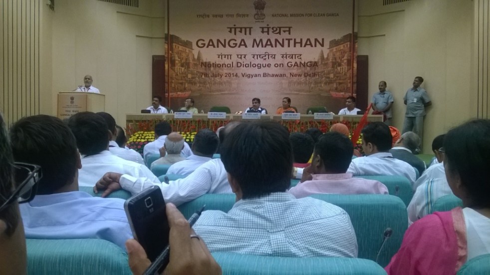
The one day Ganga Manthan[1] organized by the National Mission for Clean Ganga on July 7, 2014 was described by Union Minister[2] Sushri Uma Bharti & Union Minister[3] Shri Nitin Gadkari as “Historical”. The Union Environment Minister, who has one of the most crucial role in achieving a rejuvenated Ganga, was supposed to be there, but could not come at any stage.

I attended the full day meeting with a lingering question: Will this help the river? Even some of the ardent skeptics said that Uma ji has emotional, spiritual and religious attachment with the cause of Ganga.

At the conclave attended by close to a thousand people, the story of how Ms. Bharti came back to the BJP party about a year back to work for the cause of Ganga, and how she was promised a year back that if their party came to power, Ganga will get a separate ministry and she its charge was narrated repeatedly by both Ms Bharti and Mr Gadkari at least twice. It was also stated that the government has the commitment, the will & all the money to make the Ganga clean (Nirmal) and perennial (aviral). There were  also repeated statements by both ministers about the officials being so committed to the cause of Ganga. These, in essence, were the basic positive assets of this government to achieve Ganga Rejuvenation.

While it was good to see large gathering involving various sections of the society, including many independent non government voices, missing were some key stakeholders: Ganga basin state governments, farmers groups, Ministry of Urban Development, fisher-folk groups, boats-people representatives. Another key constituency missing was Ministry of Agriculture, since agriculture is major user of water & irrigation and responsible for water diversion and at the same time major non point source polluter through use of chemicals and fertilizers.

Rejuvenation does not mean just nirmal and aviral But if the task is Rejuvenation of River Ganga, are these assets sufficient? What exactly does Rejuvenation of River Ganga mean? There were no answers to this question at the meeting. The government did not even seem bothered about these questions. Are Nirmal and Aviral Ganga sufficient objectives to achieve Rejuvenation of Ganga? The answer is clearly no, for, even a pipleline or canal carrying perennial flow of water can claim that distinction. A rejuvenated river will need much more than that, but the government has nothing else to offer for a rejuvenated river.

Even for Aviral Ganga, the government had absolutely nothing to offer. In the information package shared with the participants, the only thing relevant to Aviral Ganga was the extended summary of draft “Ganga River Basin Management Plan” being prepared by consortium of seven IITs in collaboration with some 11 other organisations. This is led by Dr Vinod Tare of IIT Kanpur. While standing with Dr Tare and Rajendra Singh of Tarun Bharat Sangh at the lunch, I said, the problem with Ganga is not of technology[4], but of governance. Despite being a proud IITian myself, I have no hesitation in saying that IITs do not have expertise in governance issues, so how can the IIT Consortium help in fix a governance problem? Having read the full Draft Plan of the IIT consortium, it only further strengthens the view that it was wrong decision of Jairam Ramesh to give this task to IIT Consortium.

Agenda for further destruction As a matter of fact, while this government has yet to take a step that will truly help rejuvenation of Ganga, they have declared their agenda that will possibly further destroy the river. This was clear on June 6, 2014, within ten days of new government taking over when a PIB press release[5] announced, “Shri Gadkari said it is proposed to conduct dredging to provide a width of 45 meters and for a three (3) meters draft (depth) to enable transport of passengers and goods between Varanasi and Hoogly on river Ganga in the first stage of its development and eleven terminals are proposed to be constructed along the banks. He said barrages are proposed to be constructed at every 100 Kms.” This was a shocking and arrogant announcement. There is nothing in public domain about this Rs 6000 crores plan, no details as to what exactly is planned, where the barrages are planned, why are they needed, what are their environmental impacts, what are the social impacts, what are the riverine impacts, what is the cost and benefits, who will pay the costs and who will reap the benefits, where is public consultation….there is absolutely nothing in public domain and here is a nine day old government declaring such massive plan! By July 7, 2014, the PIB Press Release declared that the depth will now by 5 meters and not three announced earlier. The PIB PR now said, “He (Mr Gadkari) said barrages are proposed to be constructed at every 100 Kms on the river. Shri Gadkari said his Ministry has sent a proposal in this regard to World Bank for the development of Allahabad- Haldia corridor.”

The minister possibly does not know that there is just one barrage on the Allahabad-Haldia 1500 km long stretch, namely the Farakka barrage and Bangladesh had threatened India to take the matter about building this barrage to the UN! Moreover, that barrage, everyone accepts, has not even achieved the basic objective it was supposed to achieve, namely navigability of Kolkata port, but has had many other severe impacts.

Nitin Gadkari at GM

At Ganga Manthan, Mr Gadkari dropped a bombshell[6] when he said this plan is already in advanced stage of appraisal with the World Bank! He said the government hopes to get Rs 4000 crores from the World Bank!! The World Bank has zero track record in achieving any clean river anywhere in the world, after spending billions of dollars every year. In India itself it stands guilty of destroying many rivers. A more inauspicious start to the Ganga Manthan possibly could not have been possible. At the Ganga Manthan itself, there was opposition to this plan, as The Hindu[7] has reported.But Ms Uma Bharti finds nothing amiss about this as was clear by her answers at the press conference. But what about at least some semblance of participatory democracy?

Business as usual at NMCG and NGBRA will not help In reality, this is not all. While this Manthan for Ganga Rejuvenation is happening, the NMCG and NGBRA[8] (National Ganga River Basin Authority) go on with their work in business as usual fashion. So in Varanasi, the Uttar Pradesh Jal Nigam is going about its task of floating and examining the bids for five-part sewer laying and Sewage Treatment Plants with the help of JICA money. In Kanpur, the effort to divert several streams to Pandu is going on. In Allahabad, “the draft final ESAMP sewerage works for sewerage districts” A & C could be found on the NGBRA website. In Patna, the World Bank is funding the sewerage projects of Pahari in Patna & river front development and the draft social and environmental impact assessments could be found on NGBRA website. All of this (except the Varanasi packages, which are funded by Japanese aid agency) is going on under USD 1 Billion World Bank Funded NBGRA project.

So the business as usual that is going on for 40 years is now going to help rejuvenate Ganga!

The NMCG announced that the Manthan, a “National Dialogue on Ganga”, was supposed “to facilitate interaction with various stakeholders”, “to discuss the issues & solutions to the task of Ganga Rejuvenation”, “to prepare road map for preparation of a comprehensive plan”. The website said the Ganga is “holiest of Rivers”, “purifier of mortal beings” & “living godess”, but now “seriously polluted” and in “extreme environmental stress”.

Where is the dialogue? However, the way the meeting was organized, there was essentially no dialogue. After the inaugural plenary session, the participants were divided among four groups: 1. spiritual leaders, 2. environmentalists, NGOs, water conservationists, 3. scientists, academicians and technocrats, and administrators; 4. public representatives.

I went to the second group and there, when someone pointedly asked, if there is any representative of the government present, there was no response! In fact it was positively shocking that the first panel member that spoke in this group was Dr Arun Kumar of AHEC (Alternate Hydro Energy Centre) whose work on Ganga basin cumulative impact assessment is so discredited that even the official agencies like the Expert Appraisal Committee of MoEF, the Inter-ministerial Group on Ganga, the Expert Body appointed by the Supreme Court after the June 2013 flood disaster and the Supreme Court itself has criticized it or found it unreliable. NMCG has discredited itself by appointing such a person to give an overview of achievement of Ganga Action Plans.

GM stage

Ms Bharti apologized in the beginning for hurriedly-called meeting. But the least she could have ensured was a credible process that will ensure that the officials have to show application of mind to the various suggestions received and conduct of the meeting in credible and confidence inspiring way. But the meeting did not inspire confidence that there will be any credible process that will ensure that there is application of mind to the various inputs given. Many of the participants did not have any opportunity to speak.

Recommendations for the government on Ganga

1. Make an honest effort to learn from the past. Why have the efforts of last 40 years since the passage of Water Pollution Act 1974 not helped Ganga? Similarly why did the GAP I, NRCP, GAP II, NGBRA not helped make the Ganga clean (nirmal) or perennial (aviral)?

2. Understand & recognise that Ganga is a river and what are the essential characteristics of a Ganga that it needs to rejuvenate it as a river. At Ganga Manthan, in post lunch session in the room where the fourth group for public representatives was sitting, I was sitting next to an official of Ministry of Water Resources and I casually asked him does the ministry of water resources understand what is a river? He first said yes, but when I said you are only dealing with water and nowhere in your work have we seen any value for rivers, he said ok, but we can do it in collaboration with MoEF. The trouble is, even MoEF does not understand rivers. [It was also strange to see in this session Mr Madhav Chitale (former Water Resources Secretary) describing Tennessee Valley Authority of 1933 as an effort to clean the river! Such misrepresentation going unchallenged was shocking.] It should be remembered that it is this ministry of water resources through which Sushri Uma Bharti has to achieve a rejuvenated Ganga!

3. Ganga is not 2525 km long river: We kept hearing this sentence that Ganga is 2525 km length of river and Mr Bhurelal in fact said we need to limit ourselves to discussing how to make this stretch clean. The trouble is, if the tributaries are not healthy rivers, how can the main stem of Ganga be rejuvenated? As Manoj Misra of Yamuna Jiye Abhiyaan said, Ganga is not 2525 km, but much more than 25000 km including all the tributaries, as Yamuna is not 1400 km long but 13470 km long including all the tributaries.

4. Ganga in Mountains: Learn the lessons from Uttarakhand disaster, that affected the headwaters of the Ganga river. The Expert body constituted by the MoEF under Dr Ravi Chopra has a lot to say there. Revisit all the existing, under construction and planned projects in the whole basin.

5. Farakka barrage: It is well known that the barrage did not serve the basic purpose it was created for, namely making the Kolkata port navigable. But it has created such havoc in upstream and downstream for millions of people that some of the Bihar MPs of previous Lok Sabhas talked about decommissioning of the barrage in the debate on Ganga. But this government wants to make many more barrages! First do a post facto assessment of the Farakka barrage and its current costs, benefits and risks.

6. Formulate an Urban Water Policy: The footprint of the urban areas on the rivers is increasing in multiple ways, but we have no urban water policy. Some key elements that such a policy will include: Reducing transmission & Distribution losses, water audit from RWA upwards, Rainwater harvesting, decentralised and eco-friendly ways of sewage treatment and recycle, groundwater recharge and bottom up management, demand side management, protection of local water bodies, protection of riverbeds, floodplains and forest areas & democratisation of the Urban water utilities.  As the working report for the 12th Five Year Plan on Urban water said, no Urban areas should be allowed to have external water till they exhaust their local potential, including recycling of the treated  sewage and other demand side and supply side options. The footprint of the urban areas will increase exponentially if we do not urgently on this front.

7. Agriculture is the biggest user of water and our government encourages use of chemicals and pesticides in agriculture. Most of these chemicals end up in water bodies including rivers. If we do not want our rivers to be dumping grounds for these chemicals, the government should encourage organic farming. Similarly, in stead of encouraging water intensive cropping patterns and methods, government needs to encourage low water use crops and methods like System of Rice Intensification (SRI). SRI is applicable for many crops and can reduce water need by upto 50% and yet increase yields and incomes of farmers. But the government has shown no interest in encouraging SRI. Such methods can free up a lot of water for the river. Similarly, under the influence of powerful sugar lobby, we are producing more sugarcane and sugar than we need and than we are exporting the same at subsidized rates! So essentially we are exporting water at huge subsidized rates, that too from Ganga, but we have no water for the river!

8. Irrigation is the biggest user of water. At Bhimgoda, Bijnor and Narora barrages, we are diverting almost all the water in the river for irrigation. But we have no water for the river. If we change our water resources development and agriculture policies, it is possible to restrict these diversions to 50% and release the rest for the river. We need to review all this.

9. The IIT consortium report is seriously flawed and is not likely to help the river.

10. We need to define the path of the riverbed or right of way for the river, based on its need to carry 100 year flood and silt. In absence of such a defined space for the river, there are a lot of encroachments. There is also no river regulation law to regulate this riverways land. This is urgently required.

11. Our Pollution Control Boards and related mechanism is not known to have achieved a single clean river or nala in 40 years of their existence, anywhere in the country. This is because of the completely non transparent, unaccountable, non participatory and exclusive bodies, where people whose lives are affected by the pollution have no role. A complete revamp of this is required to make its management inclusive from block level upwards, and answerable to the local people through clearly defined management system.

12. One of the major reason for the failure of the GAP, NRCP and NGBRA is that their functioning is top down, with absolutely no clearly defined norms for transparency, accountability, participation and inclusive management. Unless we completely change this, no amount of money, no amount of technology, no amount of infrastructure or institutions is going to help the Ganga. We need management system for every STP, every freshwater plant, every city and town, every 3-5 km of the river, every tributary and so on. At least 50% members of the management committees for each of them should be from outside the government, including community members. The people whose lives and livelihoods depend on river including fisherfolk, boatspeople, river bed cultivators, local sand miners, communities depending on river for different water needs have to be represented in such management system. That will also create an ownership in river rejuvenation effort. This is also applicable to urban areas and all the tributaries.

13. This is also true for our environmental governance of dams, hydropower projects, flood control projects, water supply projects, and so on. Today there is no credible environmental management at planning, appraisal, construction, operation or decommissioning stage.

14. River of course needs water. Urgently. Chart out a road map to achieve 50% of freshwater releases from all dams and barrages in two years. Also no sewage water or effluents entering the river in two years.

In the concluding plenary, after listening to the reports from four groups (there were a lot of positive and useful suggestions there), Ms Uma Bharti and Mr Gadkari said that they won’t make any announcement today but they will ensure that the good suggestions that have come will be given to the decision-makers who will create a road map. This is very vague and unconvincing process with no credible transparency. The least the ministers could have assured is a confidence-inspiring process that would transparently ensure that the decision makers have applied their minds to the suggestions. But even that was not promised.

Despite this seemingly gloomy outcome, considering that the NMCG has invited[9] suggestions even after the meeting, I am going to send this blog link to them and wait for their response! Ganga definitely needs a lot of sewa from all of us if the river is to have any better future.

Himanshu Thakkar (ht.sandrp@gmail.com)

END NOTES:

[1] For details, see: http://www.gangamanthan.in/

[2] Union Minister of Water Resources, River Development and Ganga Rejuvenation

[3] Union Minister of Road Transport & Highways, Shipping, Rural Development, Panchayati Raj, Drinking Water & Sanitation

[4] It’s worth noting here that Mr Gadkari seems to have abiding faith in technology, he said that this is an age of technology and there are technological solutions for all problems! This possibly shows where we are heading!

[5] Title: “Development of River Ganga for Tourism, Transport and to make it Environment Friendly”

[6] PIB PR on July 7, 2014; http://www.business-standard.com/article/current-affairs/ganga-clean-up-may-cost-rs-80-000-crore-114070700889_1.html

[7] http://www.thehindu.com/news/national/plan-for-navigation-in-ganga-basin-questioned/article6187510.ece

[8] http://moef.nic.in/sites/default/files/ngrba/index.html

[9] NMCG would welcome any further suggestions, ideas, write-up etc from all interested person through email: info@gangamanthan.in

[10] Also the views of NGBRA expert member B D Tripathi that also questions Dr Vinod Tare and IIT consortium report on Ganga: http://www.thenewsminute.com/technologies/72

http://www.thenewsminute.com/technologies/71: Ganga clean up more about governance than technology: Himanshu Thakkar

http://www.thenewsminute.com/technologies/70: Experts flay Uma Bharti’s Ganga Manthan clean up plan

brahmaputra · Chenab · Ganga · Himachal Pradesh · Himalayas

How do dams affect a river?

That sounds like a rather innocent question and I was asked to write an article, addressing it. But before we go into that, let us try and understand a few things. Firstly, what is a River? Let us first try and understand that.

There is no single definition of this complex entity. For every definition, there is something more a river does.

Take the example of the one of the most complex rivers of all, the Ganga that we think we know. Before being a religious entity cultural icon, etc Ganga is, first & foremost, a River. A perennially flowing river like Ganga flows all the time. But that flow is not constant. It changes from day to night, from one day to another, from one season to another, one year to another, from one place to another.

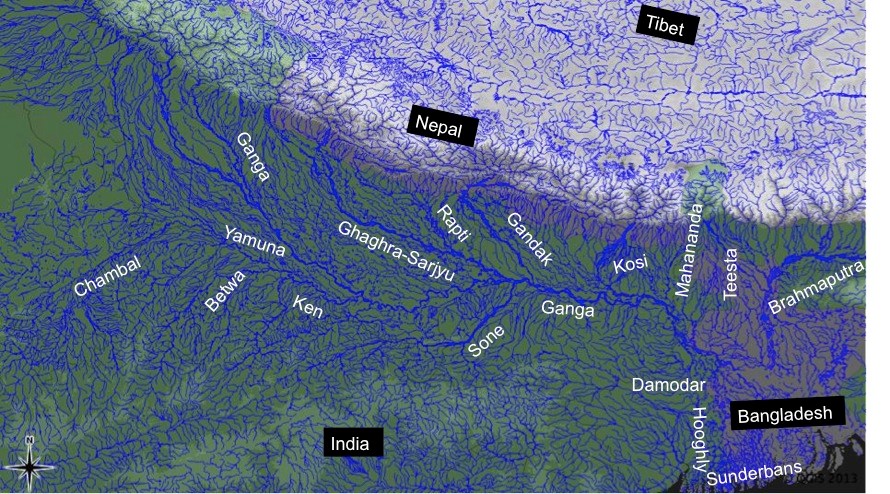
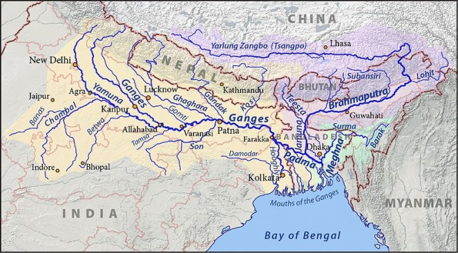
And then, the Ganga that we know is not only a single river but a collection of rivers. So Yamuna, Bhagirathi, Alaknanda, Mandakini, Dhauliganga, Pinder, Ramganga, Kali, Tons, Gomti, Ghaghra, Sone, Gandak, Budhi Gandak, Kosi & Mahananda are some of the major tributaries that directly meet Ganga. Each of them is a river in its own right.

The Ganga Brahmaputra Basin Photo from: Wikimedia Commons

Take Yamuna for example. Some of its major direct tributaries include: Tons, Giri, Som, Sahibi, Hindon, Chambal, Sind, Betwa & Ken, each of them are again significantly big rivers.

Take Chambal, some of the major direct tributaries of Chambal include: Parbati, Kali Sindh (Lakhundar, Ahu, Parwan are some of the tributaries of Kali Sindh, Newaj is one of the tributaries of Parwan, Dudhi is one of the tributaries of Newaj), Banas, Ider, Retam, Sau, Kshipra, Chhoti Kali Sindh, Cham, Siwana, Kural: each of which is a river by its own right.

Take Parbati: some of the major tributaries of Parbati include: Papnaus Ajnal, Sewan Paru, Utawali, Paraparwa, Mawal, Tem, Bhader, Gochi, Gaumukh, Sunk, Negri, Chopan, Uproni, Duhral, Andheri, Beram, Kosam, Ahelil and Sukni. These are all rivers too!

We can go on like this much longer. But such is a vast network of rivers that we call Ganga.

river

Secondly what flows in a river is not just water, though most governments, official agencies & engineers see the rivers as channels of water. Flowing water is surely a major visible defining component of a river. But even a canal or a pipeline can claim that. But unlike a canal or pipeline, a river carries dissolved matter, suspended matter, bed load, microorganisms, many levels of aquatic flora and fauna.

Thirdly, a river is a connected entity. It is connected with upstream and downstream river, biodiversity & landmass, the terrestrial land & life, underground geology and groundwater aquifers and is also connected with the floodplain. Perennial rivers like Ganga meet the sea forming a delta and this connection is vital for the river and as well as the sea. The connections are so strong that a river provides a report card about what is happening upstream and downstream, if read carefully.

From: The River continuum Concept. Species in India will be different, but this represents how biological entitites in a river are linked to each other through a number of processes including nutrient spiralling Oxbowriver.com

This is admittedly a partial description of a river, limited by the constraints of an article or blog. This is also a bit simplistic description of how humans deal with rivers, since there are exceptions. But this provides a broad direction of our journey with the rivers.

from : lakeconesteenaturepark.com

Apart from its many functions like ecological, hydrological, geomorphological ones, a river is also connected with the human society along the banks. The connection with human societies has been as long as the humans have existed. This connection is not really necessary for the river to survive, but we cannot say the same about human survival. Humans cannot survive without the rivers, though is doubtful if the human society understands or even acknowledges that reality.

More importantly, till about a century ago, our interaction with the rivers did not endanger the existence of the rivers themselves. But what we have been doing in last century has created existential threat for rivers. This threat comes in the form of big dams, diversions, chemical pollution from agriculture and industries, large dose of sewage pollution at major urban centers, encroachment on floodplains, deforestation, unsustainable groundwater use, riverfront developments, embankments, and climate change.

What humans have done to the rivers in last century can possibly be described as Terraforming (one of the grandest concepts in science fiction in which “advanced” societies reshape entire planets to suit their needs). Or what some geologists describe as Anthropocene, meaning a new geological age of humans to suggest that humans are now a planet transforming force.

It seems humans have stopped valuing the rivers as they exist in nature and decided that they can stop, bend, tunnel, channelise, divert, encroach, pollute the rivers. So when we build a dam, we do not put any value to the destruction of river & destruction of the services provided by a river that entails in the process of building the dam.

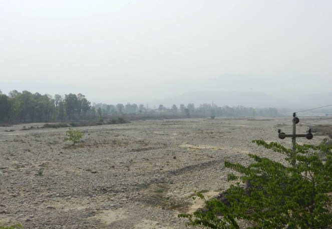
But let us get back to Rivers & what dams do to them. A river, by definition, must flow freely. A dam stops the free flow of river, and impacts the river in the most fundamental ways. In India when we construct a dam (e.g. Tehri), a hydropower project (e.g. 400 MW Vishnuprayag project on Alaknanda in Chamoli district in Uttarakhand) or diversion (Lower Ganga – Bhim Goda at Haridwar, Middle Ganga – Bijnor and Upper Ganga-Narora barrages), we do not have to leave any water for the downstream stretch of river. So complete drying up of the rivers for most of the dry months by these structures is the first direct impact of these structures on the river. To put it mildly, that action practically kills the river. Upstream of the dam too, the river gets killed, for immediate upstream there is stagnant water and further upstream, the river has lost its connections with the downstream river!

Dry Baspa River downstream Baspa II Dam, Himachal Pradesh
Dry Baspa River downstream Baspa II Dam, Himachal Pradesh Photo: SANDRP Partners

This is because these structures not only stop the flow of water to the downstream areas, they also stop flow of everything else that was flowing in the river: the silt, the nutrients, the sand, the organisms, the flora, fauna, and severe every one of the connections of rivers we described earlier

And imagine when a river has to face such death every few kilometers in its journey!

Density of dams in the Upper Ganga Basin Map by SANDRP


That is not all. As the river continues its journey, if the tributaries are flowing reasonably freely, there is some chance for the river to recover some of its defining characteristics. But we have dammed most major tributaries too.

To top it, we also have other elements that help kill the river, like pollution, encroachment, abstraction, etc, as described earlier.

And remember just about a century back Ganga and other rivers were not in such a bad shape. This is an achievement of less than 100 years.

Chandra Basin in Himachal Pradesh depicted by Nicholas Roerich in 1932. The same Chenab Basin now witnesses one of the highest dam densities in Himalayas. From: WikiArt

Some people will read in this a plea to go back by those 100 years. That is not possible, and we all know that. But there are other ways to deal with the rivers. Human society can take what is needed for the society, without destroying the river.

This is true of Ganga, as any other River!

Himanshu Thakkar (ht.sandrp@gmal.com, https://sandrp.wordpress.com/)

~~~~~~~~~~~~~~~~~~~~~~

This is 200th post from SANDRP! We always look forward to your suggestions and comments for improvement.

Our 100th Blog on River Conversations: https://sandrp.wordpress.com/2013/10/08/river-conversations/


Ganga · Hydropower

What do Rivers have to do with Silt??

Rivers are again in the news, though so far only for symptomatic reasons. The new government at the centre has renamed the charge of water resources minister to Minister of Water Resources, River Development and Ganga Rejuvenation. There is fundamental contradiction within this name plate and we have in fact yet to see this nameplate.

There is also a lot of discussion about rejuvenation of Ganga, with the Prime Minister promising the people of Varanasi Parliamentary constituency that he will rejuvenate Ganga.  There is no clarity about how he plans to go about in achieving that. His claim during elections that Gujarat Government’s Sabarmati Riverfront Development provides a model for this is clearly a non-starter. Sabarmati has water only in 10.4 km of the river stretch that flows through Ahmedabad. If you go upstream of this stretch, you will find a dry river in most non-monsoon months and if you go downstream, you will find a river more polluted than Yamuna in Delhi. And even the water that one sees in this 10.4 km stretch is not the water from Sabarmati river basin, but is taken from Narmada River via Sardar Sarovar Canal! Pertinently, Ahmedabad or Sabaramati has no right over that water: the Sardar Sarovar Project has been built and justified in the name of Gujarat’s drought-prone areas like Kutch and Saurashtra.

The nameplate-changing business also extended to Union Ministry of Environment and Forests, its name changed to Union Ministry of Environment, Forests and Climate Change, though here again the new nameplate is yet to be seen. Unfortunately, all the noises that we have heard so far from this front seem to give primacy to growth rather than environment or forests or climate change! The new environment minister has yet to say anything about river protection, but he is already talking about river linking!

So is there a hope for rivers in this new establishment, going beyond the symbolic name changes? Here one is reminded of a meeting, where one of us (HT) was invited a few months before the elections, to discuss the state and fate of Yamuna River in Delhi. When HT started speaking, he started by asking what is a river? Is it just a source of water as engineers see it? Following a sudden change in program, Sushri Uma Bharati was the chief speaker at the meeting and when it was her turn to speak , she actually tried to understand that question and tried to find an answer to it: what is a river? Her becoming the Union Water Resources Minister also raises hopes since she had been campaigning for Aviral Dhara (Continuous flow) of the Ganga and against building of dams and hydropower projects in Uttarakhand. We hope that she will realize that impact of dams and hydropower projects on rivers is similar, if not same everywhere.

Ms Bharati is also minister of river development and Ganga Rejuvenation. The question, What is a river? becomes even more relevant in that context. A river is possibly the most complex ecological entity and we still do not understand fully how to define a river. But here we would like to highlight that river is a lifeblood of the ecology and carries so much more than water. One of the key elements that river carries is silt or sediment (although there is a slight difference between the two, we will use it interchangeably here).

The rivers carry silt from various points in their journey from the hills, to the deltas where most major rivers meet the sea. In this journey, the type, quantity, movement of silt varies with place and time. The silt comes in various forms, from suspended matter to fine silt to coarser sand. It is the transfer of silt from upper catchments to the plains that helps build fertile and alluvial flood plains like the Indo Gangetic plains.

Ganga-Brahmaputra Delta during Monsoons. Pcture from : http://sebix.github.io/gallery/2012/ganges-delta-during-the-wet-season/

The flow of sediment through rivers to the delta also protects the deltas, which are very highly productive & biodiversity rich ecosystems, population centers and agriculturally fertile areas. Deltas are constantly facing the threat of erosion by sea. In this fight against erosion by sea, the sediment brought by the rivers helps the deltas in a major way. Sediment flow to delta becomes even more important when sea levels are rising in changing climate.

However, when we build dams, hydropower projects and diversion structures on the rivers, we completely change the silt flow pattern in the river. The dams arrest the silt and hydropower projects and release silt free water in the downstream. The erosion capacity of the silt free water is greater, and the additional erosion they cause in the immediate downstream may not compensate for the silt trapped in the dams. The run of the river hydropower projects may release silt annually or more frequently and also on daily basis from desilting chambers, but the pattern of transport of the silt again completely changes. Moreover the dams and diversions completely change the character of flood-flow in the downstream area, when it is established that floods are the most important sediment-transporting events. All these changes have huge impacts in the riverbeds, in the floodplains and in the deltas. And most worryingly, we do not understand these impacts completely as yet.

REbuilding a flood barrier in Bangladesh Delta, destroyed due to Cyclone Aila from : http://www.nature.com/news/floods-holding-back-the-tide-1.15013
Rebuilding a flood barrier in Bangladesh Delta, destroyed due to Cyclone Aila from : http://www.nature.com/news/floods-holding-back-the-tide-1.15013

It is only recently that scientists have started work that provides a glimpse of impacts this changing silt flow is causing. For example, our deltas are literally shrinking and sinking, and several independent scientific studies are telling us that dams must take major, about three-fourths of the blame. About 80% of the sediment that rivers bring can be trapped by the dams and this means that dams are annually trapping about 40 billion cubic meter of sediment globally. That is more than five Sardar Sarovar Dams every year! In India, our estimate earlier showed that large dams are trapping at least 2 BCM of silt every year, this figure is likely to have gone up now.

Not all the sediment trapped in the dams would reach the deltas, a significant part would have been left on the floodplains and in the river channels. And sediment trapped by dams is one of the many reasons behind sinking of deltas. However, scientists are estimating that already deltas have been deprived of at least 73 BCM of sediment by the dams. In South Asia, during the past century, Indus delta sediments have been reduced by 94 percent, Ganga-Brahmaputra delta sediments by 30 percent, and Narmada delta sediments by 95 percent.

The Ganga Brahmaputra Delta, formed of rich sediment From: EO Snap.com

In 2007-08, the Ganges, Mekong, Irrawaddy and many other rivers flooded with more than 100,000 lives lost and more than a million displaced. Most of the deltas that were flooded did not receive a significant input of sediment. These major flood events lead to sediment trapping behind mega dams.

The direct impacts of delta subsidence and effective seas level rise include inundation of coastal areas, saltwater intrusion into coastal aquifers, increased rates of coastal erosion, an increased exposure to storm surges, in addition to the threats to food security, livelihood security, water security for millions and a huge loss of biodiversity. These threats impact hundreds of millions of people who inhabit the delta regions as well as the ecologically sensitive and important coastal wetland and mangrove forests.

Sundarban Forests constitute parts of Ganga-Brahmaputra Delta from: Wikimedia Commons

As Prof. James P Syvitski, the Chair of the International Geosphere-Biosphere Programme, told SANDRP, “We must learn to do better.” However, decisions surrounding dams in most regions of the world are not even assessing the impacts on deltas. Ignoring sediments when building and operating dams comes at a huge price. Someone else is paying that price right now and this price is steeply increasing. For full SANDRP report on this issue, write to us or see https://sandrp.in/Shrinking_and_sinking_delta_major_role_of_Dams_May_2014.pdf

This article provides a glimpse of the role that rivers play in sediment transport. It goes to show how little we know about the role played by rivers in our lives. We hope we have much richer debate around the role of rivers in our lives in days to come.

Himanshu Thakkar (ht.sandrp@gmail.com), Parineeta Dandekar (parineeta.dandekar@gmail.com)

For a response to this blog by Dr D K Mishra, see: https://sandrp.wordpress.com/2014/07/05/response-to-sandrp-blog-on-sediments-rivers/

Satellite image of Brahmaputra River From: Wikimedia Commons

( An edited version of this piece appeared in the Civil Society Magazine: http://www.civilsocietyonline.com/pages/Details.aspx?563)


Beas · Disasters · Himachal Pradesh · Hydropeaking · Hydropower

Nadiya Bairi Bhayi…

In a classical Thumri rendition, Ustad Rashid Khan sings about how a river, which was once a friend, has turned into a foe…Nadiya Bairi Bhayi.. Something similar is happening at a number of places in India, where the river, a life giving friend, is turning into a deadly force.

~~

Drowning of 25 students following sudden water releases from the 126 MW Larji Dam in Mandi, Himachal Pradesh is one more saddening and shocking incidence in the long list of hydropower-release related disasters in India where rivers are turned into death traps.

On the 1Radhika8th April 2014, 11 year old Radhika Gurung studying in standard fourth was accompanying her sisters Chandra and Maya along the river Teesta near Bardang, Sikkim. Suddenly, without having any time to respond, all three school girls were washed away by a forceful water released by upstream 510 MW Teesta V Hydropower project in Sikkim. While Maya and Chandra were lucky to be saved, Radhika was not so lucky. She lost her life. Residents here say that NHPC, the dam operator, does not sound any sirens or alarms while releasing water in the downstream for producing hydroelectricity and villagers live in constant fear of the river.[1] Residents demanded strict action against NHPC, but no action has been taken.

On the 28th March 2013, 5 people, including two small children aged 2 and 3 drowned in the Bhawani River near Mettupalayna when 100 MW Kundah IV HEP (Tamil Nadu) on the Pillur Dam suddenly released discharge of about 6000 cusecs water. The family was sitting on the rocks in the riverbed when water levels started rising, and they did not get enough time even to scramble out of the river with the two children, says the sole survivor. Tangedco officials stated that although alarm is sounded at the nearest hamlets, it does not reach the downstream regions.[2] Local villagers say no alarm is sounded. No action has been taken against Tangedco.[3]

On 8th JaSearchforbodiesnuary 2012, a family of seven people, including a child, drowned in the Cauvery River when water was released from the 30 MW Bhavani Kattalai Barrage-II (BKBII in Tamil Nadu). The same day, two youths were also swept off and drowned in the same river due to this release.[4] There are no reports of any responsibility fixed or any action taken against the Barrage authorities or Tangedco, although it was found that there was not even a siren installed to alert people in the downstream about water releases.[5]
Uttarakhand has a history of deaths due to sudden releases from its several hydropower dams. In April 2011, three pilgrims were washed away due to sudden release of water from Maneri Bhali-1 Dam on the Bhagirathi in Uttarakhand.[6] In 2006 too, three women were washed away by such releases by Maneri Bhali.[7]  The district magistrate of Uttarkashi district ordered filing a case against the Executive Engineer of the dam after a number of organisations demanded action against the guilty.  Again in November 2007, Uttarakhand Jal VIdyut Nigam Limited was testing the opening and closing of gates of Maneri Bhali Stage II, when two youths were washed away by these releases. [8] Following a protest by locals and Matu Jan Sangathan, the Executive Engineer and District Magistrate simply issued a notice which said that “Maneri Bhali Hydropower Projects exists in the upstream of Joshiyada Barrage and water can be released at any time, without prior notice from here”.

Similar notice is also given by NEEPCO, which operates the Ranganadi Dam and 405 MW Dikrong Power House in Arunachal Pradesh, on the Assam border. “The gates of Ranganadi diversion dam may be opened at any time. NEEPCO will not take any responsibility for any loss of life of humans, animals or damage to property”.

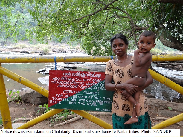
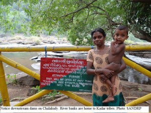
Similar notice sits on the bankAthirappillys of the Chalakudy River near the Athirappilly falls in Kerala and the Kadar tribes, which traditionally stay close to the river and are skilled fisher folk too, are fearful of entering the river.
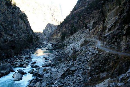
Chamera HEP in Himachal Pradesh has been held responsible for sudden water releases and resultant deaths in the downstream. As per retired IAS Officer Avay Shukla who resides in Himachal, similar incidences which resulted in loss of lives have also happened due to Nathpa Jhakri and other dams in the state.

In December 2011, three youth were drowned in the Netravathi River when water was released by the fraudulently combined 48.50 MW AMR project (Karnataka) now owned by Greenko[9]. Villagers protested at the site, but this has not been the first instance of drowning because of this project. Villagers accuse the dam for the deaths of as many as 7 unsuspecting people in the downstream. This dam is now increasing its height and one more project is being added to it.

Protest against sudden water release by fradulently combined 48.50 MW project in Bantwal, Dakshin Kannada by Greenko Photo: Daiji World
Protest against sudden water release by fraudulently combined 48.50 MW project in Bantwal, Dakshin Kannada by Greenko Photo: Daiji World

On October 1, 2006, at least 39 people were killed in Datia district in Madhya Pradesh when suddenly large amount of water was released from the upstream Manikheda dam on Sind River in Shivpuri district. There was no warning prior to these sudden releases and hence unsuspecting people crossing the river were washed away[10]. Chief Minister Shivraj Chauvan ordered a judicial probe into this incidence in 2006, however, and a report was submitted by retired High Court Judge in 2007. Since then, the report has been buried and several attempts of RTI activists to access the report have been in vain. The government has not released the report, forget acting upon it or fixing responsibility after 8 years[11].

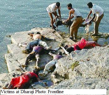
In April 2005, at lDharajiDewas Frontlineeast 70 people were killed at Dharaji in Dewas district of Madhya Pradesh due to sudden release of huge quantity of water from the upstream Indira Sagar Dam on Narmada river. Principal Secretary Water Resources Madhya Pradesh inquired into the incident and found that “there was no coordination between agencies”[12]. No accountability was fixed and no one was held responsible. NHPC, who operated 1000 MW Indira Sagar Project, simply claimed that it was a case of miscommunication and that it was not aware of the religious mela in the downstream of the river. As SANDRP observed then, “ It just shows how far removed is the dam operator from the welfare of the people in Narmada as the fair annually gathers more than 100,000 people of the banks of the river. It is a scandal that no one was held responsible for the manmade flood which resulted in the mishap[13].”
Above incidents make it clear that incident at Larji is not the first and will not be the last, if we continue non transparency and non accountability in hydropower dam operations.

Some Questions that arise from these events:

Do sanctioning authorities and dam operators reaslise that each of these projects convert an entire river ( not limited to the hydropower project) in the downstream area into a potential death trap? Do they assess the impacts of the various possible operations of the projects in the downstream area and envisage, plan and implement measures to avoid death and destruction in the downstream areas?

Can cordoning off and alienating a river, indicating that it is dangerous, be a solution to this? Are measures like alarms, sirens, lights enough when a river experiences order of magnitude sudden change in its flow due to dam and hydropower releases?

Is it ok to have hundreds of dam-related deaths in the recent years due to irresponsible and non-transparent dam operations and not have any responsibility fixed?

The obvious answer to the above seems NO.

Some Recommendations: As we have seen above, many man made disasters have happened in India over the last decade and governments  and dam operators have learnt no lessons. The avoidable tragedies are repeating without any change. India is possibly the only country in the world where such events have been happening in such large numbers. Here we are recommending some basic steps if we want to avoid or minimise occurrence of such tragedies in future.

MEASURES FOR TRANSPARENT, INCLUSIVE MANAGEMENT NORMS IN OPERATION OF ALL EXISTING DAMS AND HYDROPOWER PROJECTS:

For every operating Dam and Hydropower project in India there should be clearly defined operating procedure in public domain. This operating procedure will include the steps taken before release of water from dam or power house, how the releases will be increases (the increase should be in steps and not suddenly releasing huge quantity) or decreased, how these will be planned in advance, who all will need to be informed about such plans in what manner and what safety measures will be taken. This will also include who all will be responsible for designing, monitoring and implementing these measures. There should be boards at regular  intervals  in the downstream area in language and  manner that local people and outsiders can understand and the boards should also indicate the danger zone and what kind of sirens and hooters may blow before the releases.

The operating procedure will take into account where there are upstream projects and how the upstream projects are going to influence the inflow into the project and  how information will be shared with upstream and downstream projects and in public domain. The Power Load Dispatch Centres should also remember that when any hydropower project is asked to shut on or off, there are consequences in the river and they should be asked to keep such consequences in mind and time required to alert the regions in risk.

For every dam there should be a legally empowered official management committee for the project management, in which 50% people should be from govt and 50% should be non govt persons, including local community representatives and this committee should be in charge of providing oversight over management, including operation of the project and should have  right to get all the information about the project.

Hourly water levels and release data of hydropower dams be made available in public domain on daily bases. Water levels corresponding to discharges (and possible timings where applicable) should be physically marked on the river banks, local communities should be involved in this, evacuation methods and mock drills should be organised by dam proponent from time to time in all places along the river where the impacts reach.

THE EXISTING DAMS AND HYDROPOWER PROJECTS SHOULD BE MANDATED TO PUT ALL THIS IN PLACE WITHIN A PERIOD OF NEXT THREE  MONTHS THROUGH A LEGALLY EMPOWERED STEP IN ALL STATES.

SANCTIONING PROCESS FOR NEW PROJECTS, INCLUDING FOR UNDER CONSTRUCTION PROJECTS:

Safety measures related to, including water releases for all kind of eventualities and their downstream impacts and management plan should be an integral part of EIA and EMP. The aspect should be thoroughly discussed while appraising the project, and clear cut roles and responsibilities fixed. Mitigation measures should include proper siting of the project, gradual upramping & Downramping of releases in a clearly defined way and where planning is mandatory, safe operation of discharges through dams, etc.

Entire clearance mechanism for cascade hydropower projects in the Himalayas and elsewhere needs to be revisited to include the operational safety measures considering the cumulative operation of the projects. Projects where operational safety measures alone will not be sufficient due to massive fluctuations/location/upstream projects, etc., should be urgently dropped.

Peaking power projects should be restricted to certain locations like deep mountain gorges, after proper studies. Such projects should not be permitted as rivers enter into floodplains, due to their significant impact on the downstream and also in biodiversity rich river stretches.

SAFETY MEASURES BEFORE AND DURING WATER RELEASES: 

Primary safety measures like informing the administration well in advance before release, sirens, hoots, alarms, lights, buoys should be strictly enforced and a clear responsibility of these measures should be adopted, for the entire zone in risk, sign boards at every 50 mts interval in such zones in languages and manner that local people and outsiders can understand, and which also show the specific risk zone. Where sudden unseasonal releases are likely, include police surveillance of the risk zone during danger period.

WHEN THERE IS DEATH AND DESTRUCTION IN THE DOWNSTREAM AREA:

Exemplary punishments should be fixed not only for dam operators,but also engineers and dam companies in case of negligence. Independent inquiry will be required since departmental or inquiries by District administration or government officials are not likely to be credible.

Since the designed safety measures in case of Larji were clearly inadequate, not just the operational staff but all those responsible for such shoddy safety plan should be held accountable.

It is unacceptable that a life giving and beautiful entity like a river should be converted into a dangerous and deadly force for our energy needs, without even the most basic precautions in place.

-Parineeta Dandekar,  Himanshu Thakkar


END NOTES:

In 1999, 39 people and hundreds of animals and livestock in Cambodia was washed away and drowned by the release from Yali Falls Dam on Sesan in Vietnam. Mekong River Commission took a strong view on this. http://www.threegorgesprobe.org/pi/Mekong/index.cfm?DSP=content&ContentID=8946

Just last month, two people were washed away and drowned in Belize due to releases from a dam owned by Canadian company Fortis. Here too early warning systems, alarms and accountability are being discussed:. http://journal.probeinternational.org/2014/05/07/did-a-dam-cause-water-surge-ending-in-multiple-deaths/


References:

[1] http://sikkimfirst.in/2014/04/20/11-year-old-girl-drowns-in-teesta-river/

[2] http://www.newindianexpress.com/states/tamil_nadu/article1519865.ece?service=print

[3] http://archives.deccanchronicle.com/130328/news-current-affairs/article/five-drown-bhavani

[4] http://www.ndtv.com/article/tamil-nadu/toll-of-those-drowned-in-cauvery-rises-to-nine-165935

[5] http://lite.epaper.timesofindia.com/getpage.aspx?articles=yes&pageid=6&max=true&articleid=Ar00600&sectid=2edid=&edlabel=TOICH&mydateHid=10-01-2012&pubname=Times+of+India+-+Chennai+-+Times+Region&title=A+siren+could+have+saved+seven+lives&edname=&publabel=TOI

[6] http://www.tribuneindia.com/2011/20110524/region.htm

[7] https://sandrp.in/drp/July2006.pdf

[8] Matu Jan Sangathan, http://hindi.indiawaterportal.org/node/47403

[9] http://www.daijiworld.com/news/news_disp.asp?n_id=124216, http://www.indiawaterportal.org/articles/1-dam-2-projects-many-fools

[10] https://sandrp.in/drp/June_July-2008.pdf

[11] http://timesofindia.indiatimes.com/india/2006-tragedy-re-run-at-Datia-but-MP-govt-yet-to-release-probe-report/articleshow/24120250.cms,

http://archive.indianexpress.com/news/judicial-probe-into-datia-drowning/13990/

[12] https://sandrp.in/drp/jul_aug05.pdf

[13] http://www.internationalrivers.org/files/attached-files/nhpc_people_don27t_matter.pdf

PS:

http://www.newindianexpress.com/states/odisha/7-Students-Get-Justice-16-Yrs-after-Meeting-Watery-Grave/2014/09/18/article2437008.ece

7 Students Get Justice 16 Yrs after Meeting Watery Grave

By Express News Service Published: 18th September 2014 06:03 AM

BHUBANESWAR: In a significant judgment, a civil court on Wednesday awarded a compensation of `25 lakh each to the families of seven students of University College of Engineering (UCE) of Burla __ now VSS University of Technology __ who were swept away by unannounced and untimely release of water from Hirakud dam 16 years ago.

Civil Judge (Senior Division), Bhubaneswar, Sangram Keshari Patnaik, who pronounced the verdict in his 31-page judgement, ordered that the compensation be paid with 6 per cent interest effective from 2001, the year when the case was filed before the court.

The tragic incident had occurred on January 30, 1998 when eight students of the UCE of Burla were taking pictures on a sand bar of Mahanadi as part of the Spring Festival activity. The water flow of the river rose menacingly and barring Soubhagya Barik, the rest seven second-year engineering students were swept away and met their watery grave.

The Hirakud Dam authorities had allegedly opened nine gates during the non-monsoon season which led to the tragic incident as no caution was sounded before the release of the water.

The State Government ordered a Revenue Divisional Commissioner-level inquiry into the incident and the then RDC Hrushikesh Panda submitted the report to the Government on March 29, 1998. The Government accepted it on May 19.

The RDC, in his report, had examined 77 witnesses and 31 affidavits were filed. Panda, in his report, had highlighted the irresponsibility of the engineers and stated that even the Sambalpur Collector and the Superintendent of Police were not intimated about the  release of water, let alone the public.

Basing on the report, the State Government had announced a compensation of `3 lakh each to the family of seven students. However, considering the compensation inadequate, a petition was filed before the Orissa High Court. In 2001, the HC directed that the case must be filed before a civil court since it pertained to compensation.

According to Madhumadhab Jena and Sidharth Das, counsels for the deceased’s families, the Civil Judge Court took into account various aspects, including the academic background of the students of UCE.

Chenab · Jammu and Kashmir

Massive Kwar and Kiru HEPs on Chenab, J and K : Poor quality & cut paste EIAs, flawed public hearing

It seems we do not want to learn any lessons from the massive Uttarakhand disaster of June 2013. Two more huge capacity hydropower projects have been submitted to the Expert Appraisal Committee (EAC) of Ministry of Environment & Forest (MoEF) for grant of Environmental Clearance (EC) with very poor quality Environmental and Social Impact Assessment (EIA) reports.

EIA reports of Kiru Hydro Electric Project (HEP) (660MW) and Kwar HEP (560 MW) proposed in Kishtwar district, Jammu and Kashmir by Chenab Valley Power Projects Ltd. (CVPP) were submitted to the EAC for River for its 74th meeting held on 5-6 May, 2014 for grant of EC. The projects are run-of-river schemes proposed on river Chenab as a part of cascade development of Chenab basin.

Vicinity Map

Vicinity Map (Source Kiru EIA Report)

 Partial map of Hydro Electric Projects on Chenab river basin

Partial Map of Commissioned and Proposed HEPs in Chenab River Basin (Map by SANDRP)


Chenab basin may have one of the highest concentrations of hydropower projects among all basins in India[1]. The basin has over 60 HEPs under various stages of planning, construction and commissioning in states of Himachal Pradesh (HP) and Jammu and Kashmir (J&K).

While 49 of these projects are planned or under construction in Chenab in HP, 28 projects of combined generation capacity of 5,800 MW are at an advanced stage of obtaining (Environment Ministry) clearances[2]. State of J&K has 13 projects planned of total capacity 8,623 to 8,923 MW. These consist of at least four operational projects (of total 1563.8 MW), three under construction projects (of 1450.5 MW) and six proposed projects (of 5608.7 MW).

Table 1: Cascade Development of Chenab Basin

Source: EIA report of Kiru & Kwar

Sr. No. Scheme River Capacity
1 Salal (Stage- I & II) Chenab 690 MW
2 Sawalkot Chenab 1856 MW
3 Baglhar (Stage-I & II) Chenab 900 MW
4 Shamnot Chenab 370 MW
5 Ratle Chenab 850 MW
6 Dulhasti Chenab 390 MW
7 Kwar Chenab 560 MW
8 Kiru Chenab 660 MW
9 Kirthai-I Chenab 350 MW
10 Kirthai-II Chenab 990 MW
11 Barinium Chenab 240 MW

Himalayan ecosystem, of which the Chenab river basin is a part, is known to be geologically fragile. Cascade of hydel projects proposed on the river basins of this region would make the region even more vulnerable to extreme and erratic weather events, which will increase in changing climate. This has already been witnessed during Uttarakhand disaster of June 2013. Expert Body (EB) headed by Dr Ravi Chopra recently has officially acknowledged this connection in the report submitted to MoEF[3]. In light of this, a thorough impact assessment of all the proposed hydro power projects in this region is thus of critical importance. Various organizations and experts including SANDRP have repeatedly highlighted the fact that Cumulative Impact Assessment (CIA) of all the proposed, under construction and operational projects and carrying capacity assessment (CCA) of the river basin to see if it can support the massive number of HEPs in safe and sustainable way is one of the first steps before considering clearances to HEPs in this region. Without such a study, considering any hydropower project in the basin will be an invitation to disaster[4].

Even though the MoEF sanctioned TORs for cumulative impact assessments of the HEPs on Chenab in HP in February 2012, this critical task was entrusted to the Directorate of Energy, Government of Himachal Pradesh. This is a clear case of conflict of interest. Further the project specific ECs were delinked from the CIAs[5].

More importantly, no such study has been initiated in Chenab basin in J&K or in the Chenab basin as a whole. State of Jammu and Kashmir is not even considering CIA of HEPs on Chenab in the state as MoEF has not asked for it yet. CIA of the entire Chenab basin including HP and J&K is not being considered, which itself is violating MoEFs Office Memorandum dated May 28 2013. The OM states that all states were to initiate carrying capacity studies within three months from the date of the OM No. J-11013/I/2013-IA-I. Since this has not happened in case of Chanab basin in J&K, considering any more projects in the basin for Environmental clearance will be in violation of the MoEF OM.

On Cumulative Impact Assessment, the OM said, “While, first project in a basin could come up without insisting on cumulative impact study, for all subsequent hydro-power projects in the basin, it should be incumbent on the developer of second/ other project(s) to incorporate all possible and potential impacts of the other project (s) in the basin to get a cumulative impact assessment done.” The EIA of both the projects does not include the cumulative impacts.

MoEF continues to give clearances to individual HEP projects despite of poor quality Project Feasibility Reports (PFRs) and EIA reports submitted for appraisal. Kiru & Kwar EIA reports are a classic example of such poorly conducted EIAs. The EIAs demonstrate several serious issues across various stages from TOR non-compliance, non assessment of impacts, cut and paste job, lack of any references, faulty public hearings, the issued raised at public hearings have not been addressed in EIAs, as statutorily required. SANDRP recently made detailed submissions to EAC highlighting these issues for both the projects. Some highlights below:

Copy paste job while preparing EIA reports Both the reports are prepared by a consortium of RS Envirolink Technologies Pvt. Ltd. (Gurgaon) and Jammu University. Kiru EIA report demonstrates a casual approach towards impact prediction and proposing mitigation measures in EMP. The report also misses out on a number of important aspects of EIA like impact of construction activities on geology, flora fauna, impact of climate change, cumulative impacts of cascade development in Chenab basin etc. While Kiru EIA is inadequate on several fronts it was utterly shocking to discover that Kwar EIA report is a complete replica of the Kiru EIA Report. Entire text, save project specific numbers, remains the same in both reports, to the extent that the Kwar EIA report mentions Kiru instead of Kwar at several places!! The impact prediction for both the cases is so vague and generic that the changes in numbers for project-specific details like proposed installed capacity, submergence of reservoir, FRL, head race tunnels etc. do not reflect at all in the reports!

Brief Project Profiles Kiru H.E. Project and Kwar H.E. Project are run-of-river schemes proposed on river Chenab located in the district Kishtwar of J&K.

Kiru HEP envisages the construction of a 193 m long and 123 m high concrete gravity dam above the river bed across river Chenab at village Kiru with four intake, four pressure shafts, an underground powerhouse of 4 units of 165 MW each. Impoundment will cover an area of 1.03 Km extending 6.5 km upstream of dam. The average river bed level at the dam site is about EL 1394 m corresponding to an FRL of 1515 m, the gross storage of the reservoir is 41.50 Mcum and area under submergence is 1.03 Km.

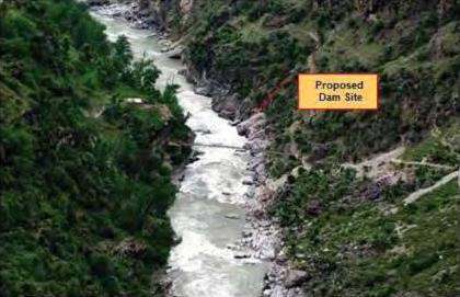
Proposed dam site for Kiru HEP

Proposed dam site for Kiru HEP(Source Kiru EIA Report)

 Kwar HEP envisages construction of a concrete gravity dam 101 m high from river bed across river Chenab at village Padyarna, four number intakes, four pressure shafts, an underground powerhouse to accommodate 4 units of 140 MW each and two number tail race tunnel. FRL of reservoir is proposed at EI 1385M. Gross storage of the reservoir at FRL is 27.167 Mcum. The reservoir will submerge an area of about 0.8 Sq. Km at FRL.

Proposed dam site for Kwar HEP

Proposed dam site for Kwar HEP (Source Kwar EIA Report)

 TOR non-compliance First and foremost glaring issue about the proposed projects is the non-compliance with the TORs (Terms of Reference) laid down for conducting the EIA. These TORs were granted by MoEF. We have listed here only an indicative list of non compliance below, not an exhaustive one.

Kiru HEP The TOR clearance letter was issued for Kiru project on Sept 9, 2008, the TORs are valid for a period of 3 years, but the project developer never came back for extension of the TOR on expiry of 3 year period and has come now for EC over 5.5 years after the TOR clearance. Thus the TOR clearance is no longer valid for Kiru HEP as per the law. Also originally the TOR clearance for Kiru was given for 600 MW installed capacity. The EIA however has been conducted for 660 MW capacity. No permission was sought by the PP for this increased capacity.

Kwar project has undergone several changes since the grant of TOR on 17 March 2010. Table given below compares some of these changes. First and foremost alteration has been in the proposed total power generation. While the TORs were granted for 520 MW the EIA has been conducted for 560 MW. Number of affected families goes up by 160% and project cost escalates by 29%. The TORs were granted for over four years back and the project authority never got back to EAC/MoEF for renewal of the TOR as other projects do. Thus the TORs granted originally do not remain valid in this case too.

Table 2: Changes in the scope of Kwar project after grant of TOR on 17 March 2010
Sr. No. Parameter Scope at the time of TOR clearance Current scope of the Proposed Project
1 Total power Generation 520MW 560 MW
2 Land requirement 5 Ha Government land 93.66 Ha Government land
3 Power House Units 4 x 130 MW (4 x 140MW)
4 Affected families 35 91
5 Project Cost Rs 3386.11 Cr Rs. 4375.50 Crores at Jan’2012 PL

Casual approach towards impact prediction

 Kwar EIA copy pasted from Kiru EIA report: It is evident that the EIA consultants have done nothing but copy paste job while preparing Kwar EIA report. At certain places Kwar report mentions ‘Kiru’ instead of Kwar. See for example point number 1.7 in Index of Kwar EIA mentions ‘Need of the Kiru HE project’ instead of Kwar and point number 4.4 mentions ‘Basin characteristics of free draining area of Kiru HEP’ (p.3 & p.6 of the document). Page 28 of Kwar EIA states that “The case for forest clearance of Kiru HE Project for diversion of 29.75 ha of forest land has been approved in the 81st meeting of J&K State Forest Advisory Committee (FAC) held on 09.12.2013…”

Other than very project specific figures, the entire text for both the reports is exactly the same. Impact prediction is the heart of an EIA study. However in Kwar EIA report an important chapter like Chapter 8- “Identification, Prediction and Evaluation of Environmental Impacts” is also copy pasted. The text of the chapter is same as that of Chapter 8 from Kiru EIA report save the project specific numbers and their description. The impacts predicted are vague and are conveniently kept the same in both the reports. It is clear that no real field work or application of mind is done. Such an EIA study defeats the basic purpose of conducting an EIA.

Impact of construction activities: The Kiru project involves a reservoir of live storage 10.5 MCM, a concrete dam on height (from river bed) 123.0 M & length 193 M, construction of 4 head race tunnels (of 7 m dia and 165 to 190 m length each) for discharging the water to an underground powerhouse of 4 units of 165 MW each. The project also envisages 33.4 Lakh CuM of construction material required from the project site.

The Kwar project involves construction of 101 m (above river bed)/ 109 m (above deepest foundation) high concrete gravity dam, Underground power house complex of four units of 140 MW each, Two concrete lined 9.5 m internal diameter main tailrace tunnels (having length of 2676 m and 2883 m) amongst several other features like four 5.65 m internal diameter main pressure shafts (each with a length of 108-182 m), etc. The project also envisages 38.36 Lakh CuM of construction material required from the project site.

View of Naigarh Nala Rock Quarry at Kwar Dam site

View of Naigarh Nala Rock Quarry at Kwar Dam site (Source Kwar EIA Report)

 All these activities will have significant impact on the geology and hydrology of the region. However no significant assessment or quantification of these impacts in terms of change in drainage patterns, springs in the project area, increased thereat of landslides, seismic activities has been carried out.

While talking about the impact of construction activities, the only impact of these two EIAs discussed in the chapter is ‘muck generation’. It does not mention impacts of tunneling and blasting involved in construction and also does not talk about its impact on fragile geology and hydrology of Himalayan region at all[6]. While talking about quarrying activities in the same chapter it states only two impacts viz. visual impacts and noise generation[7]. Impacts on landslides have been randomly dismissed stating that the sliding activity may not be significantly induced by project construction activities[8]. The reports trivialize the impacts on migratory fish Mahseer by stating that the upstream migration of this fish from the lower reached of the Chenab River have already been blocked by Salal and Baglihar, Dul Hasti dams. Thus they conclude that impact of this project on this fish species is not expected to be significant[9]. Option for fish ladder and fish lift has been ruled out for both the projects stating that it is not techno-economically feasible at the project site. Development of a hatchery at the project site has been proposed instead. The impact of the project on all the fish available in the river should have been assessed based on baseline assessment of the fisheries in Chenab River, which is not done. Secondly, there is no credible evidence to show that hatchery as a management option is useful or effective.

Left Bank slide for Kiru Project downstream of Ludrari Nala

Left Bank slide for Kiru Project downstream of Ludrari Nala (Source Kiru EIA Report)

 Right Bank slide for Kiru Project about 16 km downstream of Gulab Gargh

Right Bank slide for Kiru Project about 16 km downstream of Gulab Gargh (Source Kiru EIA Report)


The southern boundary of the Kishtwar National Park is approximately at an aerial distance of 11 km away from the proposed project, it is claimed, but this needs to be independently assessed. Also, just because it lies outside the boundary of study area which is radius of 10 KM, the EIA does not consider the impacts on this national park at all! EIA reports for both Kiru and Kwar HEPs simply state that the proposed activities shall have no impact on the National park[10].

Biodiversity at Kishwar National Park I

Biodiversity at Kishtwar National Park (Photo: Travel Places[11] & Beauty Spots of India[12])

 Several Important aspects of EIA are missing

No mention of free flowing river stretch: There is no mention of what is the flowing river stretch upstream and downstream of the project. As is clear from the EIA, the elevation difference between FRL of Kiru HEP (1515 m) and TWL of upstream Kirthan II (1526.5 m) is just 11.5 m. The elevation difference between TWL of Kiru HEP (1388 m) and FRL of downstream Kwar HEP (1385 m) is just 3 m. Similarly the elevation difference between TWL of Kwar HEP (1270 m) and FRL of downstream Hasti HEP (1264 m) is just 6 m. However, it is not clear what the flowing river lengths in all these locations are. Unless this length is assessed and is found to be adequate for river to regain its vitality, the project should not be considered and it should be asked to change the parameters.

Environmental Flows: The Kiru EIA report states that significant downstream impacts related to the water quality, fisheries, socio-economic and aquatic biodiversity are not foreseen since toe power house is proposed downstream of the dam and tail water level is EL 1388.52 m, discharge will be less only in a “very small stretch of about 800 m”. This seems to show the ignorance of the EIA consultants about how biodiversity in a flowing, lively river like Chenab survives.

Kwar EIA report states that the water entering the reservoir will be released back to river at a distance of 2.6 KM downstream. The report claims that though there in no human activity in this stretch of 2.6 KM the aquatic life will be definitely affected, as also terrestrial biodiversity, groundwater recharge, use of river and silt flow pattern.

10% of average of lean season discharge has been prescribed to be released through the dam gates as environmental flow for both the projects. This quantity has been calculated as 9.0 cumecs based on discharge data of the river. There is no mention of environmental flows in EMP. Firstly, this is even below the norms being followed by EAC and MoEF (30% in monsoon, 20% in lean season and 25% in rest, each at 90% dependability). Secondly, the amount of E-flow required needs to be arrived at based on actual assessment, but no such assessment has been done.

Impact of peaking generation not assessed: The reports talk about advantage of hydropower in terms of ability to providing peaking power. However, when a project operates as peaking station, there are severe impacts in the downstream and also upstream (rim stability). These impacts have not been assessed, nor is it assessed how the project will perform in the cascade development it is in.

Some other important aspects of impact assessment that report misses out on are:

  • Impact of the project on disaster potential in the project area as well in the downstream due to construction and also operation at various stages, say on landslides, flash floods, etc.
  • Social and Environmental Impacts of construction and operation of the coffer dams and diversion tunnels during construction phase are not included.
  • The reports do not even mention Climate Change.Impact of climate change on the project and impact of the project on the local climate has not been assessed. No mention or attempt has been made about or to assess the impact of green house gas emissions from the project.
  • Impacts on the flood characters of the river due to this dam, what will be the changes and how these will impact downstream areas.
  • Impact of changing silt flows downstream from desilting chamber and from silt flushing in monsoon on the downstream areas not analyzed. A detail account of how the silt from the dam would be flushed out annually and what would be the impact of this in the downstream as well as on the geo morphology, erosion, stability of structures etc was not done.
  • Options Assessment is missing, this is crucial part of the EIA to establish that among all options, including non project option, the given option is the least cost and best option.

Cumulative Impacts not assessed The EIA report gives list of Major hydroelectric projects executed /under execution/ under investigation so far in the basin in J&K which are a part of Cascade Development. Kirthan HE Project (990MW with proposed FRL at 1764 m and TWL at 1526.50m) which is yet to be commissioned is proposed upstream of Kiru (660 MW with FRL at 1515M). Downstream of Kiru is Kwar HE Project (560 MW with FRL at 1385 m and TWL at 1270 m) which is yet to be appraised and Dul Hasti HE Project (390 MW with FRL at 1264 m) which is commissioned.

Impoundment of Chenab at Dul Site

Impoundment of Chenab at Dul Site (Source: Kwar EIA Report)

 Moreover, the EIA does not provide the list of hydropower projects being taken up in Chenab basin in upstream Himachal Pradesh[13]. The cumulative impacts of all such projects will be huge.

The report summarizes cumulative impacts in single sentence: “The increased pressure will include uncontrolled logging, hunting of wildlife, non-timber forest product collection, livestock husbandry, the cultivation in forest areas and forest fires.”[14]

EIA report completely misses out on the detailed analysis of cumulative impacts in terms of

  • Impacts on flora, fauna, carrying capacity, livelihoods
  • Impact of reduction in adaptive capacity of the people and area to disasters in normal circumstance AND with climate change
  • Impacts on springs and drainage pattern
  • Disaster potential of the area
  • Tunneling and blasting
  • Geological disturbance caused
  • Seismic impacts
  • Carrying capacity

Inadequate Dam Break AnalysisThe Dam break analysis does not take into account the cumulative disaster potential including existing and proposed upstream and downstream projects. The EIA report also does not include cumulative disaster management plan.

Improper Public Hearing Public hearing conducted for both the projects were flawed. Excerpts from the speeches made by the officials from J&K State Pollution Control Board (SPCB) and CVPP that are noted in the public hearing report show that what these persons spoke was inappropriate, misleading and intimidating[15]. Also point wise responses to the issues raised by people at the Public Hearing are not provided in the EIA, as statutorily required. Hence even when people ask for Resettlement and Rehabilitation as per latest Act of 2013 (made effective from Jan 1, 2014), the EIA talks about National Resettlement and Rehabilitation Policy of 2007. The public hearing report strangely end for both projects with the officials asking those who are for the projects to raise their hands. There is no formal provision for voting for or against the project. Such public hearing should be declared null and void and fresh public hearing should be conducted.

Poor quality EIA reports that reflect pro hydro bias of the consultant EIA is the most effective tool to ensure environmental compliance in India. Needless to state that it is of critical importance. Casually predicted, unaddressed impacts and copy paste job of the Kiru and Kwar EIA reports once again highlights the poor quality of EIA reports submitted to the ministry for grant of EC. These reports decide fate of the project, of the people and environment surrounding the project site. Such quality of the report is most definitely not acceptable.

Further, an EIA report is an attempt to understand what are the adverse social and environmental impacts of a project and weather the impacts are acceptable, if the project is viable, optimal and desirable. The answer to this exercise can also include the answer that the project is not viable or desirable or acceptable. In view of this, the EIA consultant needs to be completely unbiased and should be ready to even conclude that the project is unacceptable. However, in case of the EIA consultant for the Kiru & Kwar HEP, EIA starts in very 1st chapter with a shockingly unscientific and biased statement: “Hydropower projects are dependable, renewable, economic, environmentally benign sources of energy with ability to stop and start instantaneously.” This statement is factually wrong on many counts (e.g. hydropower project is renewable or dependable or environmentally benign source of energy). It, along with whole para 1.2 also reflects the bias of the EIA consultants RS Envirolink Technologies Pvt Ltd (with Jammu University) and we urge the EAC and MoEF to reject such poor quality and biased EIAs and take other necessary steps to debar such agencies from doing any EIA or environmental studies in future.

CONCLUSION Looking at serious issues above, based on merit of the EIA reports, as well as complete cut-paste jobs, we are hopeful that the MoEF will not recommend EC for these projects. This case also highlights the importance of cumulative impact assessment in an over developed Himalayan basin. When the experience with Uttarakhand flood disaster of June 2013 is fresh, we hope that MoEF will not commit another blunder.

Amruta Pradhan, SANDRP

END NOTES:


[1]https://sandrp.wordpress.com/2013/07/01/pm-kick-starts-850-mw-ratle-project-in-jk-without-full-impact-assessment-invitation-to-another-disaster-in-chenab-basin/

[2]https://sandrp.in/hydropower/Dams_on_Chenab_How_many_are_too_many_Dec2012.pdf

[3]https://sandrp.wordpress.com/2014/04/29/report-of-expert-committee-on-uttarakhand-flood-disaster-role-of-heps-welcome-recommendations/

[4] Refer to SANDRP studies on Chenab

https://sandrp.wordpress.com/2013/07/01/pm-kick-starts-850-mw-ratle-project-in-jk-without-full-impact-assessment-invitation-to-another-disaster-in-chenab-basin/

https://sandrp.in/hydropower/Dams_on_Chenab_How_many_are_too_many_Dec2012.pdf

https://sandrp.wordpress.com/2014/05/06/massive-hydropower-capacity-being-developed-by-india-himalayas-cannot-take-this-onslought/

[5]https://sandrp.wordpress.com/2013/07/01/pm-kick-starts-850-mw-ratle-project-in-jk-without-full-impact-assessment-invitation-to-another-disaster-in-chenab-basin/

[6]p.291 of Kiru EIA Report & p.288 of Kwar EIA report

[7]p.293 of Kiru EIA Report & p.289 of Kwar EIA report

[8]p.298 of Kiru EIA Report & p.294 of Kwar EIA report

[9]p.307 of Kiru EIA Report & p.303 of Kwar EIA report

[10]p.221 of Kiru EIA Report & p.223 of Kwar EIA report

[11]http://www.4to40.com/travel/index.asp?p=Kishtwar_National_Park&state=Jammu_and_Kashmir

[12]http://beautyspotsofindia.com/kishtwar-national-park-jammu-kashmir/

[13] See for example: https://sandrp.in/basin_maps/Hydro_%20Electric_Projects_in_Chenab_River_Basin.pdf

[14]P. 306 of Kiru EIA

[15]The Public hearing report of Kiru says that Shri Sajjad Mufti, Regional Director of J&K SPCB said at the public hearing, “Construction of project should not deteriorate the environment….” This is a very strange, untruthful and inappropriate statement from J&K SPCB official. Why should the official be speaking at all at the public hearing and that too make such a statement that would also affect the atmosphere of the public hearing? Similarly the statement of GM of CVPP at the public hearing, “The most viable and cleanest of all (sources of power) is hydro power” was again, wrong, intimidating and inappropriate. The statement of Shri Khursheed Ahmed Butt of CVPP, “forest clearance has already been granted to the proposed project” is incorrect since the proposal for forest clearance for the project has not even come before FAC. Such public hearing should be declared null and void and fresh public hearing should be conducted.

The Public hearing report of Kwar says that the GM of CVPP said at the public hearing, “The best source of power generation is hydro power” was wrong, intimidating and inappropriate. The statement, “forest clearance has already been granted to the proposed project” is incorrect since the proposal for forest clearance for the project has not even come before FAC.

[16] See for details and link to PCA orders: https://sandrp.wordpress.com/2013/12/23/international-court-asks-india-to-release-more-water-and-rejects-plea-to-re-interpret-february-verdict-on-kishanganga/

Assam · brahmaputra · Embankments · Floods

Matmora (Assam) Geo-tube Embankment on Brahmaputra: State Glorifies, but No End to Peoples’ Sufferings after Three Years of Construction

The state of Assam in the northeastern India annually bears the brunt of floods and where embankment construction and repairing seems like permanent affair. Displacement of people living on the banks of rivers due to river bank erosion is another major issue here. The braiding and meandering river Brahmaputra and its tributaries continue to erode the banks rapidly. The Brahmaputra is well known for the rate in which it erodes. Among the places in the path of the river where the brunt of erosion has been felt severely include the following:

–        Rohmoria and Dibrugarh town in Dibrugarh district,
–        Matmora in Dhakukhana subdivsion of Lakhimpur district,
–        Majuli and Nimati Ghat in Jorhat district,
–        Lahorighat in Morigaon district and
–        Palashbari and Gumi in Kamrup district.

Map of areas taken up for erosion protection in Assam (Source– Assam 2011, A Development Perspective, published by Planning and Development Dept., Govt. of Assam)
Map of areas taken up for erosion protection in Assam. Source– Assam 2011, A Development Perspective, published by Planning and Development Dept., Govt. of Assam

SANDRP recently traveled to Matmora and Nimati ghat, two of these areas.

Bearing the Brunt of Erosion Silently Once a large village now only the name Matmora remains. Locals show us towards the middle of the river, to indicate where the village used to be. The rate of erosion is such that the Brahmaputra dyke from Sissikalghar to Tekeliphuta (popularly known as Sissi-Tekeliphuta dyke/embankment) takes the shape of a bow for nearly five kilometers at this place. From 2010, Matmora became very significant in the embankment history of India since country’s first embankment using geo-textile technology was constructed here. This was constructed at the bow shaped eroded line using geotextiles tubes. These tubes were filled up using water and sand from the banks of the river. This five kilometer embankment became a part of the Brahmaputra dyke from Sissikalghar to Tekeliphuta which is 13.9 km long. For the state government and Water Resources Department (WRD) of Assam, Matmora geotube embankment is a story of success of preventing floods and erosion. But what we saw in Matmora presents a different picture.

At Nimati Ghat, the river Brahmaputra is eroding its banks ferociously and people are intimidated by the river. A local person whose village used to be nearly two kilometers from the present bank line, told me, “Nothing can stop Baba Brahmaputra from claiming what he wants”. At Nimati Ghat, the Water Resources Department (WRD) is doing anti erosion work using geo-bags.

Funding for Embankments in Assam The total length of embankments in Assam is 4448 km as stated in a debate in the Legislative Assembly of Assam in 1998. Even though the present length of embankments is not known, it is very clear that the state of Assam continues to construct of newer embankments. In a recent analysis by SANDRP, it was found that the funds continue to increase for construction of embankments in the state. In five years from January 2009 to December 2013, the Advisory Committee in the Union Ministry of Water Resources for consideration of techno-economic viability of Irrigation, Flood Control and Multi-Purpose Project Proposals (TAC in short) had given clearance to projects worth Rs 1762.72 crores. A detailed list of these sanctioned projects can be found in Annexure 1 below.

Matmora Geo-tube embankment after its construction in 2010. Source– Assam 2011, A Development Perspective, published by Planning and Development Dept., Govt. of Assam.

Has Geo-tube been helpful for the people   Between January 2009 to December 2013, the Brahmaputra dyke from Sissikalghar to Tekeliphuta, was considered twice by the TAC. The committee in its 95th meeting on 20th January 2009 accepted the project titled “Raising and Strengthening to Brahmaputra dyke from Sissikalghar to Tekeliphuta including closing of breach by retirement and anti-erosion measures (to protect Majuli and Dhakukhana areas against flood devastation by the Brahmaputra, Lakhimpur district, Assam). The estimated cost of this project was Rs 142.42 crore and its project proposal envisaged – (i) Raising and strengthening of embankment for a length of 13.9 km, (ii) Construction of retirement bund with geo-textile tubes of length 5000 m. (iii) Construction of 2700 m long pilot channel.

Geo-tube embankment in Matmora, three years after construction. Photo: SANDRP.

Protection work of the same dyke was considered in the 117th meeting held on 21st March 2013 under the proposal for “Protection of Brahmaputra dyke from Sissikalghar to Tekeliphuta at different reaches from Lotasur to Tekeliphuta from the erosion of river Brahmaputra Assam.” The estimated cost of this project was Rs 155.87 crore. According to the minutes of 117th TAC meeting, the scheme envisaged “restoration of existing embankment in a length of 15300m at upstream and downstream of existing geo-tube dyke, Sand filled mattress in a length of 15604 m at river side slope, geo-tube apron length of 7204 m and Reinforced concrete porcupines as pro-siltation device at different reaches to prevent floods and erosion in Dhakukhana Civil sub-division of Lakhimpur district and Majuli sub-division of Jorhat district.” In the same minutes,while referring to the previous project proposal of 95th meeting the minutes stated that, it “was taken up primarily for closure of breach in the existing embankment including raising of embankment around the breach area only. The proposed works in the present scheme were in the same river reach and these would be required to protect the bank from further erosion and provide flood protection.”

This clearly shows that the geo-tube embankment in Matmora cannot be called a success. Government documents which showed that major part of the Brahmaputra dyke from Sissikalghar to Tekeliphuta remained vulnerable even after the construction of the geo-tube embankment. In fact submitting a proposal for the whole Sissi-Tekeliphuta embankment at first and later saying that the money was spent in constructing a smaller part of the embankment also raise questions. The time gap between the two proposals also raises questions. If the whole money from first proposal was to be spent in constructing only a part of the embankment, why was it not stated clearly in the first proposal? In fact, this was not stated in the first proposal and second proposal reflects that the first project failed to achieve the objectives. If the first proposal was indeed only for part of the embankment, why the proposal to strengthen the larger part of the embankment took 5 years to appear before the committee? The latter proposal also did not mention about the breach which swept away a large part of the Sissi-Tekeliphuta embankment from Jonmichuk to Amgiri Tapit under Sissikalghar and Jorkata village panchayat. According to the local people this breach occurred in the morning hours of 25th June 2012. The photo below shows the breach happened at the Jonmichuk end.

The breached area of 2012. This photo is taken from the new embankment and the lake formed at this spot can also be seen. Photo - SANDRP
The breached area of 2012. This photo is taken from the new embankment and the lake formed at this spot can also be seen. Photo – SANDRP

Jonminchuk area is nearly 15 km upstream of the geotube embankment in Matmora and part of the Sissi-Tekeliphuta embankment. A new embankment of nearly four kilometer long is being constructed at this place but the remnants of the old embankment still exist. The embankment was breached for nearly 3 kms and the water which entered the fields during that time could no longer go out and a large lake has been formed at this place, see the photo. It was surprising to see people living in the patches of the old embankment.

In the downstream, right from the point where the geo-tube embankment ends, the condition of the Sissi-Tekeliphuta embankment is pathetic. There were cracks in the embankment and water seepage has almost shattered the embankment. The embankment was in need of urgent repairs.

Condition of the Sissi-Tekelphuta embankment at the end point of the geo-tube embankment towards the village side. Photo - SANDRP
Condition of the Sissi-Tekelphuta embankment at the end point of the geo-tube embankment towards the village side. Photo – SANDRP
Sissi-Tekelphuta embankment at the same spot mentioned above towards the river side.  Photo - SANDRP
Sissi-Tekelphuta embankment at the same spot mentioned above towards the river side. Photo – SANDRP

Besides, one does not have to travel far to find erosion in the downstream of the geo-tube embankment. After travelling, less than three kilometers from the end point of the geo-tube embankment, rapid erosion was observed at the place where the Matmora and Tekeliphuta ghats join, due to low water level. This joint ghat is more than a kilometer from the toe line of Sissi-Tekeliphuta embankment but seeing the rapidity of the erosion the locals opine that the river would reach the toe of the embankment within this monsoon. It was difficult to believe that the river can erode so fast, until a young man pointed towards a black line in the middle of the river and said that that area which now seemed to be char/sand bar used to be his village three years back. He with his family now live beside the embankment. In this ghat we also witnessed that spurs constructed from the embankment inside the river, mainly to divert the flow of water, have been eroded as well.

The Spur has also been eroded. Photo - SANDRP
The Spur has also been eroded. Photo – SANDRP
Erosion at Matmora-Tekeliphuta Ghat. Photo - SANDRP
Erosion at Matmora-Tekeliphuta Ghat. Photo – SANDRP

It is also important to note that protection of Majuli from floods was one of the main aims of the geo-tube embankment project, but there were reports of devastating floods affecting Majuli in 2012 & 2013.

After geo-tube comes geo bags With the construction of geo-tube embankments being hailed as a success by the state government, construction of embankments using geo-bags followed. Geo-bags are smaller than geo-tubes and come at a cheaper cost. Embankments on many rivers were constructed using geo-bags which were also used for erosion protection. But effectiveness of the geo-bags as protective measure to flood and erosion, still remains disputed. A news report titled “ADB, river engineers differ on geo-bags” published in Assam Tribune on 9th September 2010 reported about the difference of opinion among the water resource engineers of Assam and powerful lobby of the Asian Development Bank (ADB) for the use of geo-bags to resist Brahmaputra erosion in Palasbari-Gumi and Dibrugarh. Referring to the engineers the news report stated “They have alleged that the ADB provided 23,000 geo-bags for an experiment. They were dumped in the month of September 2009 at a 150-metre-long selected erosion-prone reach at Gumi for testing their efficacy. But, a diving observation made in the month of December 2009, suggested that the bags were not launched uniformly in a single layer as it was claimed. They were found lying in a haphazard manner in staggered heaps with gaps in between and the total distance they covered was only about 8 metres, against the claimed and required 35 metres…..The ADB then carried out another diving observation at Gumi in May last (2010) and found no bag at the site. The State WRD did not get any feedback from the ADB on this issue.”

Work of piling up the geo-bags is going on in Nimati Ghat. Photo - SANDRP
Work of piling up the geo-bags is going on in Nimati Ghat. Photo – SANDRP
Status of the geo-bags put last year. Photo - SANDRP
Status of the geo-bags put last year. Photo – SANDRP
The spot where not a single Geo-bag was seen.  Photo - SANDRP
The spot where not a single Geo-bag was seen. Photo – SANDRP

Nimati Ghat was the other place which SANDRP visited to find out the effectiveness of geo-bags. The work of piling up the geo-bags for erosion protection was going on when SANDRP visited the area in the second week of April 2014. The bags which were used previously for the same purpose were seen to be mostly lying in water in shattered condition. Locals told us that majority of the bags are now under water. In the eroded bank line, these geo-bags were lying without any order and in a way suggesting how the river has dealt or to say played with these jumbo bags. In this bank line, there was a stretch of nearly five meters where the river has eroded more than the other parts. At this stretch none of the geo-bags were to be seen.

There were also contradictions regarding when the present erosion protection work at Nimati ghat had started. Some of the shopkeepers of the ghat said that the work of putting up geo-bags started in February 2014. But according to the contractor in charge of the work, the work started in November 2013. Construction or repairing of embankment just few months before the advent of monsoons is one of the constant criticisms, leveled against the Water Resources department of the state and in Nimati too we heard the same complaint.

Is Geo-tube really a ‘permanent solution’ to floods? In the present discourse of floods in Assam this has become a very significant question. The local people have been fed with various information about geo-tube and most of which are wrong. The life of embankment constructed using geo-tube is of 100 years, we were told by the locals when we travelled to the upstream areas of Matmora geo-tube. This is absolutely not true. In fact, for Prof Chandan Mahanta of IIT Guwahati the scouring[1] done by the river Brahmaputra will be the major cause of concern for geo-tube embankments in the long run.

The geo-tube embankment has already faced threat of scouring right after its construction in the monsoons of 2011. It was on the morning of 14th July, 2011 when two of the apron tubes at the tail of the embankment, were launched due to increase force of water. The apron tubes were laid at the toe of the geo-tube embankment and with the increased force of water scoured at the bottom by the embankment toe line. WRD engineers flung into action and immediate repairing work was taken up at the site. According to WRD engineers this had happened because the trees which were  left outside the  embankment  had  obstructed  and  increased  the  force  of  water and they were immediately cut down. Concrete porcupines were also thrown into the water. Asomiya Pratidin, a regional newspaper reported this on that day but thereafter no report on this could be found. The incident was almost forgotten. When we visited the geo-tube embankment, it was observed that along the toe-line of the embankment a scour line runs for substantial length of the embankment. This clearly shows that scouring by the river has increased in this area. The news report published in Assam Tribune [2]also points out a significant problem associated with geo-bags – “The lobby is mounting pressure for use of geo-bags in the form of bank revetment. Bank revetment is generally not adopted in Brahmaputra because of many reasons. Most important of them is – it produces a permanent deep channel along the existing riverbank.”

On the issue of lobbying behind geo-tube, an interesting perspective was provided by activist-researcher Keshoba Krishna Chatradhara who coordinates ‘Peoples’ Movement for Subansiri and Brahmaputra Valley (PMSBV)’. He opines that the construction of geo-tube embankment in Matmora was an experiment, done to see whether such embankments can withstand the flood and erosion of Brahmaputra. The reason for choosing Matmora first and not other severe erosion affected places like Dibrugarh or Rohmoria, was because even if the embankment fails it won’t be as significant loss for the state compared to those places. Dibrugarh is one of the most important towns of upper Assam with a glorious history whereas Rohmoria became important for the state when Oil India Limited found oil deposits in Khagorijan[3]. Infact several local people and activists also opined that the Sissi-Tekeliphuta embankment which is on the north bank of the river was cut several times, to save the areas in the upstream south bank, mainly the Dibrugarh town. They said that in the past, before the geo-tube embankment came, whenever there was any news of water rising in Dibrugarh, there would soon be a breach in Sissi-tekeliphuta embankment. In fact considering these breaches in the larger Sissi-tekeliphuta embankment, Mr. Chatradhara opined that even if the geo-tube embankment survives the flood, erosion and breaches in future, it might become a small island in midst of a submerged land as there will surely be breaches in the rest of the Sissi-Tekeliphuta embankment.

ADB loan for Geo-textile Embankments in Assam After the construction of the geo-tube embankment at Matmora, the state government is leaving no stone unturned to make it sound like a glorious success. But it is surprising to know that, even before the Matmora embankment was commissioned in December 2010, the state government have filed proposal for two more embankment project where geo-textile would be used for construction and got it cleared. The two subprojects of Assam Integrated Flood River Bank Erosion Risk Management Project (AIFRERM) in Dibrugarh and Palashbari were cleared in the 106th meeting of TAC held on 16th September 2010. It is important to note that for the total AIFRERM project ADB is giving a loan of $56.9 million. The cost of Dibrugarh and Palashbari subprojects are Rs 61.33 crore and Rs 129.49 crore respectively. But these investments have been cleared without even doing a post-construction impact assessment of Matmora geo-textile embankment. The Palashbari subproject also included erosion protection for Gumi area through the use of geo-bags but the Assam Tribune report quoted above already mentioned about how geo-bags scheme has failed in that area.

It is important to note here that, the first geo-tube embankment has been constructed only three years back and it would be premature to give any verdict of success, on the contrary there are many signs of failure. But the state government of Assam and the Assam Water Resources department are claiming it as success without really any credible basis and than have used that self certification to go on building more embankments using geo-textile and in several occasions these plans have failed. They first should have done a detailed impact assessment of the embankment at Matmora before going on building more embankments of the same nature.

It seems the Assam government, ADB and CWC are pushing these projects to deflect attention from the failure of embankments in flood management. Such attempts won’t succeed, but it is possibly a ploy to prolong the use of embankments as a flood management technique.

Parag Jyoti Saikia (meandering1800@gmail.com)

Annexure 1

Flood and Erosion Projects approved for Assam – 2009 to 2013

TAC meeting no & date Project Appr. year River/ Basin L of Emba. (m) Original (revised) Cost-CrRs Benefitting area (Ha) Decision
95th -20.01.2009 Protection of Sialmari Area from the erosion of Brahmputra 2002 Brahmaputra NA 14.29 (25.73) NA Accepted
Protection of Bhojaikhati, Doligaon and Ulubari area from the erosion 2002 Brahmaputra NA 14.52 (27.92) NA Accepted
Raising & strengthening Brahmputra Dyke from from Sissikalghar to Tekeliphuta including closing of breach by retirement and anti erosion measures New Brahmaputra NA 142.42 NA Accepted
96th -16.02.2009 Flood protection of Majuli Island from Flood and Erosion Ph-II & III New Brahmaputra NA 115.03 NA Accepted
Restoration of Dibang & Lohit rivers to their original courses at Dholla Hattiguli New Brahmaputra NA 23.32 (53.11) NA Accepted partly & suggested that proposal of coffer dam, pilot channel, etc. to be put up for expert opinion
101st -30.11.2009 Raising and strengthening to Puthimari embankment New Brahmaputra NA 30.23 15000 Accepted
Anti Erosion measures to protect Brahmputra Dyke on left bank New Brahmaputra NA 27.97 5000 Accepted
Protection of Gakhirkhitee & adjoining areas from erosion New Brahmaputra NA 19.06 20,000 Accepted
102 -28.1.’10 Emergent measures for protection of Rohmoria in Dibrugarh District New Brahmaputra NA 59.91 18,000 Accepted
106th -16.09.2010 Raising and strengthening of tributary dyke along both banks of Kopili River New Kopilli/ Brahmputra NA 110.72 NA Accepted
Assam Integrated Flood River Bank Erosion Risk Management Project New Brahmaputra NA 61.33 NA Accepted
Assam Integrated Flood River Bank Erosion Risk Management Project New Brahmaputra NA 129.49 NA Accepted
110th – 20.07.2011 Protection of Majuli from Flood and Erosion Ph II & III 2011 Brahmaputra 115.03 Accepted
Restoration fo rivers Dibang & Lohit to their original courses at Dholla Hatighuli 2011 Brahmaputra 54.43 Accepted
111th – 17.08.2011 Protection of Biswanath Panpur including areas of upstream Silamari and Far downstream Bhumuraguri to Borgaon against erosion New Brahmaputra 167.09 Accepted
117 – 21.3.’13 Protecion of Sissi-Tekeliphuta dyke from erosion – Lotasur to Tekeliphuta New Brahmaputra 153000 m 155.87 153000 m Accepted
118th – 30.07.2013 Flood management of Dikrong along with river training works on both banks embankment New Dikrong/Brahmaputra 105.96 Accepted
Flood management of Ranganadi along with river training works on both bank embankments New Ranganadi/Brahmaputra 361.42 Accepted

[1] Scour can be termed as a specific form of the more general term erosion. In case of geo-tube embankments Scour is the removal of sediment from the bottom of the geo-tubes. Scour, caused by swiftly moving water, can scoop out scour holes, compromising the integrity of a structure.

[2] ADB, river engineers differ on geo-bags – http://www.assamtribune.com/scripts/detailsnew.asp?id=jun2410/at08

[3] See ‘Rohmoria’s Challenge: Natural Disasters, Popular Protests and State Apathy’ published in Economic and Political Weekly, Vol XLVI NO 2, Janurary 8, 2011.

Arunachal Pradesh · Assam · brahmaputra · Embankments · Ministry of Water Resources

Analysis MoWR’s Advisory Committee’s Decisions for Northeast – January 2009 to Dec 2013

This is analysis of the decisions of the Advisory Committee in the Union Ministry of Water Resources for consideration of techno-economic viability of Irrigation, Flood Control and Multi Purpose Project Proposals (TAC in short) for North East India[1] from 95th meeting of January 2009 to 122nd meeting held in December 2013. In our last analysis of TAC minutes we have covered the decision taken for NE states from July 2011 to December 2013 which  is available at – https://sandrp.wordpress.com/2014/03/19/lack-of-transparency-and-accountability-remains-the-norm-of-functioning-for-mowrs-advisory-committee/. In this analysis, we have covered the same for an extended period. In these five years TAC has accepted project proposals worth of 5515.46 crores. In calculating the total cost of the projects considered we have considered only the projects whose proposals were given clearance by TAC. In these five years, some of the projects also made two appearances with revised costs. In such cases the higher revised cost has been taken into consideration, e.g. Khuga Multipurpose Project and Dolaithabi Barrage Project, both located in Manipur were accepted by the committee in its 100th meeting (held on 9th October 2009) with revised cost of Rs 381.28 crore and 251.52 crore respectively. In the 115th meeting (held on 24th July 2012) of the TAC, these two projects were considered again where the cost for Khuga Project was Rs. 433.91 cr and for Dolaithabi Project it was Rs. 360.05 Cr. The same is the case for the Thoubal Multipurpose Project which appeared in 101st and 115th meeting of the TAC.

Within these five years, TAC has given financial clearance to 26 flood and erosion control projects and majority of these projects are from Assam. The committee gave the clearance to 6 irrigation projects, 3 barrage projects and 3 multipurpose projects.[2] The committee also gave clearance to a strom water drainage improvement project below Greenfield Airport at Pakyong in Sikkim within this period.

In this period, largest no of considered (25) and approved (20) projects were from Assam. Assam also has the maximum cost of projects among all states (Rs. 2631.99 Cr). Highest number of projects were considered (16) and approved (14) in the year 2009, with total cost of Rs 2321 Crores, which too was highest among all the years.

As found in our previous analysis, in the last five year from 2009 to 2013 TAC has not rejected a single project. Five projects had been deferred but were approved in the subsequent meetings within the same period. In the 108th meeting (held on 4th January 2011), the TAC did not discuss two projects on the Brahmaputra river stating “It was observed that the flood control and anti erosion scheme of Brahmaputra Board are implemented through Central Fund, which do not require investment clearance from the Planning Commission. Therefore, these schemes need not be put up to the Advisory Committee. However, the technical aspect of such project may be looked into by Central Water Commission as per past practice.”  But both these projects were reconsidered in the 110th meeting of TAC (held on 20th July 2011) and were cleared by the committee.

So this seems like a rubber stamping committee, clearing everything that comes to it. Reading of the minutes of the meetings also reveals that there are hardly any critical questions asked on merits of the questions for the massive delay and cost escalations that most of the projects suffer. Nor is there an discussion about the performance of the projects.

As we noted earlier, this committee functions in most non transparent, non participatory and unaccountable way. Neither the minutes nor the agenda notes of the meetings are in public domain. Following our letters along with TAC analysis in April 2011, addressed to Planning Commission, Union Ministry of Water Resources, Central Water Commission and members of the National Advisory Council, for the first time, TAC minutes were put up on CWC website (see: http://www.cwc.gov.in/main/webpages/TAC%20minutes.html). However, the last uploaded minutes were for the 115th meeting held in July 2012, after which minutes have stopped being uploaded. Secondly, some of the links are not working and all the files are unnecessarily large PDF files since only scanned pages of the minutes are put up, in place of the PDFs of normal word files, which would be of much smaller size. The TAC also has no independent, non government members, all the members are government officials. As we wrote to MoWR and Planning Commission in April 2011 and again in March 2014, there is urgent need for TAC to have  such members so that they provide objective perspective about the projects that come up before TAC.

The importance of functioning of this committee cannot be over emphasised. As we  wrote  in our letter to MoWR and Planning Commission, TAC “considers dozens of such projects with huge economic, social, environmental and other implications for the country in every one of its meetings. All of these projects are supposed to be public purpose projects, and are taken up using public resources. The Planning Commission accords investment clearance to the projects only after the TAC clearance. This Committee’s decisions are perhaps the ones which impact on India as a whole the most – as they relate to land and water – which are the basic life sustaining and livelihood providing resources for the people.”

It is high time that first effective steps are taken to ensure that the functioning of this committee becomes more transparent, participatory and accountable.

State-wise list of projects cleared by TAC

State No of Projects Considered No of projects approved Total cost of the projects
Arunachal Pradesh 4 4 106.6
Assam 25 20 2631.99
Manipur 10 10 2268.99
Meghalaya 1 1 5.63
Sikkim 1 1 48.55
Tripura 6 6 453.7

Note: No projects from Mizoram and Nagaland have come to TAC in this 5 years period.

Year-wise List of Projects Cleared by TAC

Year No of Projects Considered No of projects approved Total cost of the projects
2009 16 14 2321
2010 5 5 663.67
2011 12 9 497.33
2012 5 5 2208.81
2013 9 9 1439.45

Meeting-wise List Projects Cleared by TAC January 2009 to December 2013

Sl. No Meeting no Date of meeting No of projects considered No projects approved No of projects deferred No of projects rejected Total cost of the accepted projects, Rs Crore
95th 20.01.2009 4 3 1 0 196.07
96th 16.02.2009 2 2 0 0 168.14
100th 09.10.2009 6 5 1 0 264.73
101st 30.11.2009 4 4 0 0 77.26
102nd 28.01.2010 1 1 0 0 59.91
103rd 11.03.2010 1 1 0 0 302.22
106th 16.09.2010 3 3 0 0 301.54
108th 04.01.2011 2 0 2 0 0
109th 04.03.2011 3 3 0 0 70.13
110th 20.07.2011 5 4 1 0 211.56
111th 17.08.2011 1 1 0 0 167.09
112th 14.09.2011 1 1 0 0 48.55
115th 24.07.2012 5 5 0 0 2208.81
117th 21.03.2013 1 1 0 0 155.87
118th 30.07.2013 2 2 0 0 467.38
119th 29.08.2013 2 2 0 0 601.67
120th 13.09.2013 1 1 0 0 42.96
121st 08.10.2013 2 2 0 0 146.01
122nd 20.12.2013 1 1 0 0 25.56
Total   47 42 5 0 5515.46

95th meeting (20.01.2009): Accepted TOTAL – Rs 196.07 crores (revised costs have been taken into consideration)

SN Project Dist/ State Appr. year River/ Basin Original (revised) Cost-CrRs Decision
1 Protection of Sialmari Area Morigaon/ AS 2002 B’putra 14.29 (25.73) Accepted
2 Protection of Bhojaikhati, Doligaon and Ulubari AS 2002 B’putra 14.52 (27.92) Accepted
3 Protection of Majuli Island Ph II-III AS New B’putra 116.02 Deferred the proposal with suggestion to prepare the cost at current prices.
4 Raising & strengthening Dyke from from Sissikalghar to Tekeliphuta including closing of breach by retirement and anti erosion measures AS New B’putra 142.42 Accepted

96th meeting (16.02.2009): Accepted Total – Rs 168.14 crores

SN Project Dist/ State Appr. year River/ Basin Original (revised) Cost-CrRs Decision
1 Flood protection of Majuli Island Ph-II & III AS New B’putra 115.03 Accepted
2 Restoration of Dibang & Lohit rivers to their original courses at Dholla Hattiguli AS New B’putra 23.32(53.11) Accepted partially & suggested that proposal of coffer dam, pilot channel, etc. may be put up to the Standing Committee for expert opinion

100th meeting (09.10.2009): Accepted: TOTAL – Rs 897.53 crores

SN Project Dist/ State Appr. year River/ Basin L of Dam Original (revised) Cost-CrRs Benefit Irri CCA Annual Irrigation Decision
1 Borolia Irrigation Project AS 1980 Brahmaputra 92 m 6.775 (135.93) 9717 15,000 Ha Deferred due to non-submission of State Finance Concurrence
2 Khuga Multipurpose (Major- Revised) Manipur 1980 Khuga/ Imphal 230 m 15 (381.28) 9575 14,755 Ha Accepted
3 Dolaithabi Barrage Project (Med Revised) Manipur 1992 Iril/ Manipur 79 m 18.86 (251.52) 5,500 7,545 Ha
4 Gumti Irrigation Project (Revised) Tripura 1979 Gumti 96 m 5.88 (83.01) 4,486 9,800 ha Accepted
5 Khowai Irrigation Project (Revised) Tripura 1980 Khowai 96 m 7.10 (83.01) 4,515 9,320 Ha Accepted
6 Manu Irrigation Project Tripura 1981 Manu 82 m 8.18 (98.71) 4,198 7,600 Ha Accepted

101st meeting (30.11.2009): Accepted TOTAL – Rs 1059.26 crores

SN Project State Appr. year River/ Basin L of Dam Original (revised) Cost-CrRs Benefit Irri CCA/ flood prot. Annual Irrigation Decision
1 Raising & strengthening to Puthimari embankment Assam New B’putra NA 30.23 15000 Ha NA Accepted
2 Anti Erosion measures to protect left B’putra Dyke Assam New B’putra NA 27.97 5000 Ha NA Accepted
3 Protection of Gakhirkhitee and its adjoining areas Assam New B’putra NA 19.06 20,000 Ha NA Accepted
4 Thoubal Multipurpose Project (revised) Manipur 1980 Thoubal/ Imphal 1074 m 47.25 (982) 21,862 ha 33,449 Ha Accepted

102nd meeting (28.01.2010): Accepted TOTAL – Rs 59.91 crores

SN Project Dist/ State Appr. year River/ Basin Original Cost-CrRs Benefit-flood protsn Decision
1 Emergent measures for protection of Rohmoria in Dibrugarh Dist Assam New Brahmaputra 59.91 18,000 Ha Accepted

103rd meeting (11.03.2010): Accepted: TOTAL Cost of approved projects: Rs 302.22 crores

Project Dist/ State Appr. year River/ Basin L of Dam Original (revised) Cost-CrRs CCA (Ha) Annual Irrigation (Ha) Decision
Champamati Irrigation Project Chirag/AS 1980 Champamati/B’putra 258.5 m 15.32 (309.22) 17,414 24,994 Accepted

106th meeting (16.09.2010): Accepted TOTAL – Rs 301.54 crores

SN Project Dist/ State Appr. year River/ Basin Original (revised) Cost-CrRs Decision
1 Raising & strengthening of tributary dyke on both banks of Kopili River Assam New Kopilli/ B’putra 110.72 Accepted
2 Assam Integrated Flood River Bank Erosion Risk Management Project Dibrugarh/ Assam New Brahmaputra 61.33 Accepted
3 Assam Integrated Flood River Bank Erosion Risk Management Project Palasbari/ Assam New Brahmaputra 129.49 Accepted

108th meeting (04.01.2011): Accepted TOTAL- Rs 0

SN Project Dist/ State Appr. year River/ Basin Original (revised) Cost-CrRs Decision
1 Restoration of Dibang & Lohit rivers to their original courses at Dholla Hattiguli AS New Brahmaputra 23.32(53.11) The technical aspect pf this type of project may be looked in to by CWC as per past Practices.
2 Protection of Majuli Island from flood & erosion, Ph II-III AS New Brahmaputra 116.02 The technical aspect pf this type of project may be looked in to by CWC as per past Practices.

109th meeting (04.03.2011): Accepted TOTAL – Rs 70.13crores

SN Project Dist/ State Appr. year River/ Basin Original (revised) Cost-CrRs Decision
1 Anti Erosion & Flood Protection work in Dikrong Basin Arunachal Pradesh New Dikrong 23.68 Accepted
2 Anti Erosion & Flood Protection work in Bhareli sub Basin Arunachal Pradesh New Bhareli 16.81 Accepted
3 Anti Erosion & Flood Protection work in Siyom Basin Arunachal Pradesh New Siyom 29.64 Accepted

110th meeting (20.07.2011): Accepted: TOTAL: Rs 211.56 crores

Sl No Project Dist/State Appr. year basin original cost (Rs. Cr) decision
1 Anti Erosion & Flood protection in Tawangchu basin ArP New Tawangchu 36.47 Accepted
2 Protection of Majuli from Flood & Erosion Ph II & III Assam 2011 Brahmaputra 115.03 Accepted
3 Restoration of rivers Dibang and Lohit to their original courses at Dholla Hatighuli Assam 2011 Brahmaputra 54.43 Accepted
4 Protection of Balat village from flood and erosion of river Umngi in W Khasi hill district West Khasi hill/Meghalaya New Brahmaputra 5.63 Accepted

111th meeting (17.08.2011): Accepted: TOTAL: Rs 167.09 crores

Project Dist/State Appr. year basin original cost decision
Protection of Biswanath Panpur including areas of upstream Silamari and Far downstream Bhumuraguri to Borgaon Sonitpur/Assam New Brahmaputra Rs 167.09 Cr Accepted

112th meeting (14.09.2011): Accepted: TOTAL: Rs 48.55 crores

Sl No Project Dist/ State Appr. year original cost (Rs. Cr) decision
1 Improvement of Strom Water Drainage below Greenfield Airport at Pakyong Sikkim  New 48.55 Accepted

115th meeting (24.07.2012): Accepted: TOTAL: Rs 2208.81 crores

Sl No Project Dist/State Appr. year basin original cost (Rs. Cr) decision
1 Thoubal Multipurpose project Manipur 1980 Brahmaputra 1387.85 Accepted
2 Khuga Multipurpose project Manipur 1980 Brahmaputra 433.91 Accepted
3 Dolathabi Barrage Project Manipur 1992 Brahmaputra 360.05 Accepted
4 ERM of Imphal Barrage Project Manipur New Brahmaputra 16.8 Accepted
5 ERM of Sekmai Barrage Project Manipur New Brahmaputra 10.2 Accepted


117th meeting (21.03.2013): Accepted: TOTAL: Rs 155.87 crores

Sl No Project Dist/ State Appr. year basin Ht / L of Dam/Embnk. original cost (Rs. Cr) Benefit flood prot. (Ha) decision
Protection of Sissi-Tekeliphuta dyke from erosion – Lotasur to Tekeliphuta Assam New Brahmaputra 153 km 155.87 10117 Accepted

1188h meeting (30.07.2013): Accepted: TOTAL: Rs 467.38 crores

Sl No Project Dist/ State Appr. year River/ basin original cost (Rs. Cr) Benefit flood prot. (Ha) decision
Flood management of Dikrong and river training works on both banks embankment Lakhimpur/ Assam New Dikrong/ Brahmaputra 105.96 9998 Accepted
Flood management of Ranganadi and river training works on both bank embankments Lakhimpur/ Assam  New Ranganadi/ Brahmaputra 361.42  21056 Accepted

119th meeting (29.08.2013): Accepted: TOTAL: Rs 601.67 crores

Sl No Project Dist/ State Appr. year River/ basin original cost (Rs. Cr) annual irrigation decision
Dhansiri Irrigation project Assam 1975 Dhansiri/ B’putra 567.05 Accepted
ERM of Singda multipurpose project Manipur  New Brahmaputra 34.62 3000 Accepted


120th meeting (29.08.2013): Accepted: TOTAL: Rs 42.96 crores

Project Dist/State River original cost (Rs. Cr) decision
Anti erosion work along river Haora from Champakpur to Baldakhal W Tripura Haora 42.96 Accepted

121st meeting (08.10.2013): Accepted: TOTAL: Rs 146.01 crores

Sl No Project Dist/ State River original cost (Rs. Cr) Benefit flood prot. (Ha) decision
Anti erosion work along river Gumti from Dlak Samatal Para to Durgapur under Amarpur, Udaipur & Sonamura subdivision S & West Tripura Gumti 54.99 2209 Accepted
Anti erosion work along river Khowaii from Netajinagar to Banglahour under Telimura subdivision and from south L. N. Pur to Paharmura bridge under Khowai subvision West Tripura Khowaii 91.02  4256 Accepted

122nd meeting (20.12.2013): Accepted: TOTAL: Rs 25.56 crores

Sl No Project Dist/State River original cost (Rs. Cr) decision
Loktak Lift Irrigation Project Manipur 25.56 Accepted

 Parag Jyoti Saikia and Himanshu Thakkar

————————————–

[1]While this article only contains the details of the North East India Projects considered in TAC for the five years, we hope to soon provide details of the projects considered by TAC from all over India.

[2] Sicne Khuga Multipurpose, Thoubal Multipurpose and Dolaithabi barrage project, all from Manipur appears twice in this period, they have calculated only for once here.

[3] Feature image – Khuga Mutipurpose project. Image courtesy – http://manipuronline.com/

Arunachal Pradesh · Assam · brahmaputra · Embankments · Ministry of Water Resources · Sikkim

Lack of Transparency and Accountability Remains the Norm of Functioning for MoWR’s Advisory Committee

The Advisory Committee in the Union Ministry of Water Resources (MoWR) for consideration of techno-economic viability of Irrigation, Flood Control and Multi Purpose Project Proposals (TAC in short) is a very important committee. It accords the financial clearance for any irrigation, flood control and multipurpose project. TAC is supposed to discuss the techno-economic viability of projects as per the resolution published in the Union of India Gazette Notification No. 12/5/86-P-II dated Nov 27, 1987. This committee came into being replacing a similar committee that existed earlier in the planning commission. Even now, the guidelines for functioning of the committee are issued by the Planning Commission.

The Gazette notification cited above also said, “The committee may also invite representatives of any other Government organizations, scientific body of experts in the relevant fields to participate in its deliberations.” This seems like a window to appoint credible, independent, non-government persons in the committee, but this window does not seem to have been used. Among the functions of the committee listed in this notification include, “The functions of the Committee will be to examine projects proposed by State Governments, Central Government or other organizations and satisfy itself that the schemes have been prepared after adequate investigations” and “the need of environment conservation and proper rehabilitation of project-affected persons have been taken into account.” However, our perusal of the functioning of the TAC shows that TAC has failed to fulfill both these mandates.

As noted in the Guidelines for Submission, Appraisal and Clearance of Irrigation and Multipurpose Projects, 2010 available on the CWC website (see: http://www.cwc.nic.in/main/webpages/publications.html), “The project proposal, thereafter, is put up to the Advisory Committee for clearance, which is, by and large, like single window clearance.” The importance of such a single window clearance becomes all the more important. The guidelines further note, “On the basis of examination conducted by the Advisory Committee, decision on techno-economic viability of the projects is taken in the meeting of this Committee. The projects found acceptable by the Advisory Committee shall be recommended for investment clearance by the Planning Commission and inclusion in the Five Year Plan/Annual Plan.” This shows how important is the role of the TAC in judging techno-economic viability of projects and also from the point of view of prudent planning.

No Transparency, independent participation or accountability of TAC Considering the above, there is strong case for clearly defined norms for transparency, participation and accountability in (1) functioning of TAC; (2) The screening process of the projects at initial stages that also happen under these guidelines in the Central Water Commission, based on which approval for DPR preparation is given.

In view of the significance of TAC, this is SANDRP’s third analysis of the decisions taken in TAC meetings. The present analysis covers decisions taken for North East India from 110th to 122nd TAC meeting. In the two previous analysis done by SANDRP, TAC meeting decisions taken from 95th meeting to 109th meeting has been covered. Here it is important to note that lack of transparency has been observed right from the agenda and minutes of the TAC meetings. The agenda and minutes of the TAC meetings should be uploaded on CWC website but CWC website has minutes only till the 115th meeting held on 24th July 2012 and the website has been last updated on 31/08/2012.

In this analysis we have covered 13 TAC meetings held from July 2011 to December 2013. In these 13 meeting, 21 projects from 6 northeastern states have been considered. But out of the 13 meetings held, projects from northeast were considered only in 10 meetings. TAC has accepted the proposals for projects with a total cost of rupees 4075.46 crore. Majority of the projects were given clearance at the first time of consideration. Thus, on an average TAC  had cleared projects worth of 407.55 crores from the North East in each of these 10 meetings. Number of the projects considered by TAC in each meeting along with their total cost is given below. A state-wise and a project-wise list is also provided.

Total Cost of Projects Cleared by TAC July 2012 to December 2013

Sl No Meeting no Date of meeting No of projects considered from NE No projects approved No of projects deferred No of projects rejected Total cost of the accepted projects, Rs Crore
1 110th 20-07-11 5 4 1 0 211.56
2 111th 17-08-11 1 1 0 0 167.09
3 112th 14-09-11 1 1 0 0 48.55
4 115th 24-07-12 5 5 0 0 2208.81
5 117th 21-03-13 1 1 0 0 155.87
6 118th 30-07-13 2 2 0 0 467.38
7 119th 29-08-13 2 2 0 0 601.67
8 120th 13-09-13 1 1 0 0 42.96
9 121st 08-10-13 2 2 0 0 146.01
10 122nd 20-12-13 1 1 0 0 25.56
  Total     20     4075.46

State-wise list of projects cleared by TAC

Sl. No State No of projects approved Total cost of the approved projects, Rs Crore
1 Arunachal 1 36.47
2 Assam 7 1526.85
3 Manipur 7 2268.99
4 Meghalaya 1 5.63
5 Sikkim 1 48.55
6 Tripura 3 188.97

Note: No projects from Mizoram and Nagaland have come to TAC in this 30 month period.

Some observations regarding TAC meetings

1. Zero Rejections The TAC did not reject a single project. There was only one project which was deferred in the 110th meeting but it was approved in the next meeting. Rest of the new projects were were approved in the very first meeting of their consideration.

2. Lack of information The TAC minutes provide little information about projects. Specially in case of newer projects, detailed discussions should have happened. The minutes of TAC meetings do not give much of an idea about size, location, benefits of a particular project. In the project- wise list provided towards the end of this analysis, we have provided limited information available in the minutes. Some of the noteworthy missing information is listed below:

– In the 115th meeting, 5 projects from Manipur were considered. Out of these five projects, 2 were multipurpose projects and 3 were barrage projects. Surprisingly, there was no information about where these projects are located, on which river, what the size of these projects. None of the minutes mentioned about whom these projects will actually benefit. Only two projects mentioned about increase in annually irrigated land but no more detail was provided.

– In the 118th meeting, construction of embankments on both banks of river Ranganadi for flood management and river training was considered. But the cost of the project was on the higher side compared to the embankment construction work to be done on the river Dikrong, considered in the same meeting. This cost escalation may be due to the difference in the length of the projects. But this cannot be confirmed since minutes do not mention the length of the proposed embankments.

India's First Geo-tube embankment in Matmora in Dhakuakhana sub-division of Lakhimpur district in Assam.  Photo: Parag Jyoti Saikia
India’s First Geo-tube embankment in Matmora in Dhakuakhana sub-division of Lakhimpur district in Assam. Photo: Parag Jyoti Saikia

But the increased costs may also be due to the use of Geo bag technology for construction of Ranganadi embankments. Use of Geo-bag technology is a costly affair but nothing has been mentioned about the use of this technology in the minutes of 118th meeting. This is stated in the annexure (Annex VI as mentioned in the document) of the meeting. Interestingly this annexure too has been mentioned only as a corrigendum.

3. No Detailed Discussion on Projects Considered This was very evident in the two previous analysis done by SANDRP and situation remains the same this time as well. In case of all the projects, including the ones considered for the first time, there was no detailed information or any detailed discussion. There is no discussion on technical viability of the project. Reading through the minutes gives an impression that approval for any project considered by TAC is fait accompli. There is no discussion about whether the project is a desirable project, if there are other options available, if this is the best option and so on. Under the mandate given to it, TAC is supposed to discuss all these issues. TAC accepted projects proposals with huge cost and time overruns but little enquiry has been made why such escalation happened.

Dhansiri irrigation project This is a glaring example of cost escalation. The project was discussed in the 119th meeting on 29.08.2013 for consideration of cost of Rs 567.05 crores. But, it was surprising to find that original cost of the project in 1975 was Rs 15.83 crores as according to the information available in Assam State Irrigation Department website.[1] The same website states that project started in 1975 and supposed to be completed 35 years later in 2010. In the TAC meeting a new time schedule of March 2015 was stated. The cost of the project has increased by 35.82 times over a period of 40 years but the advisory committee accepts proposal without much scrutiny or enquiry. There was no detailed assessment of the reasons for time and cost over runs (there is no question of delay due to clearances or agitations here) or whether this project which will take 40 years just to complete will be viable or not. On the contrary, the planning commission representatives said, “the benefit cost ratio of the project was 1.2 and any further escalation in cost would result in the project becoming techno-economic unviable.”

The TAC should have done a detailed assessment why the project took so long time to complete. But it seemed to be contended with the rational that the project authorities provided which was that due land acquisition and law and order problem the project has not been completed. But in the meantime minutes of the meeting also showed that that major components of the project are in advanced stages of construction with 93% of barrage work, 99% of the canal works and about 83% of works in the distribution system were reported to have been completed. There has been no detailed assessment in to any of these aspects.

Imphal Barrage project In this project, the cost of the project mentioned in the minutes of the 115th meeting contradicted with the cost provided in the annexure. The cost of Extension, Renovation and Modernization (ERM) of the Imphal barrage project as mentioned in the minutes is Rs 16.80 crores. But a letter from the Under Secretary, Govt. of Manipur to the Chief Engineer of Irrigation and Flood Control Department, Manipur dated 21.07.2012 stated the cost of the project as 23.41 crores. This reflects the lack of serious discussion over projects in TAC. It is also surprising that TAC, being the committee which gives the techno economic clearance to projects, does not have clarity about even the cost of the project.

4. No Discussion over Social, Environmental and Other impacts of the Projects The projects cleared by TAC have serious social, environmental and other impacts but the committee never discussed these impacts. TAC does not at all take into account the impacts a project would have on the environment.

In the 118th meeting (30.07.2013), while considering the proposal for flood management of Dikrong along with river training works on both banks, the minutes stated “Effectiveness of existing embankments of river Dikrong has been deteriorating due to lack of repair, siltation of river bed and consequential change in river behaviour, change in flow pattern due to release of Ranga Nadi hydel project etc.” But this is one of the rare instances when TAC mentioned about the environmental impacts on embankments. But rather than asking for more details on these impacts or to see whether embankment would really be a viable option or not, the TAC accepted the proposal. On the other hand nowhere the committee discussed what impacts an embankment has on river bed, siltation or downstream stretches of a river.

Dikrong Power Station at Hoz where water from Ranganadi HEP is released in Dikrong. Photo: Parag Jyoti Saikia
Dikrong Power Station at Hoz where water from Ranganadi HEP is released in Dikrong/Pare. Photo: Parag Jyoti Saikia
Dikrong at Dikronghat in Lakhimpur district of Assam where it erodes rapidly. The impacts of change is water flow is clearly visible. Due to release of water in upstream water at night covers the lower portion of the bank. This photo was taken around 8am in the morning when the water receded. The lower bank portion was wet in the morning. According to the local the water further recedes by the evening and again increases at night. Photo: Parag Jyoti Saikia
River Dikrong at Dikronghat in Lakhimpur district of Assam where it erodes rapidly. The impacts of change is water flow is clearly visible. Due to release of water in upstream water at night covers the lower portion of the bank. This photo was taken around 8am in the morning when the water receded. The lower bank portion was wet in the morning. According to the local the water further recedes by the evening and again increases at night. Photo: Parag Jyoti Saikia

It is also important to note here TAC also does not take into consideration impacts of the hydropower projects on the embankments in the downstream of the river. In the above mentioned case, the increased costs of Dikrong embankment should have been charged on the Ranga Nadi HEP, but there is no discussion on this. The Pare hydropower project (110 MW) in Papumpare district of Arunachal Pradesh is currently under construction on Dikong / PareRiver. Moreover there are at least 10 hydropower projects at various stages in the combined Ranganadi-Dikrong basin in Arunachal Pradesh, including one operating, three TOR approvals given and five additional MoA signed (in addition to a proposed project). There is no provision to assess the impacts of these projects on the embankments downstream of DikrongRiver in Assam. In fact there is no provision for any impact assessment study for embankments even though studies show the disastrous impacts of embankments on environment, floods and on the lives of the people living close to the river.

5. Clearing Same Embankment Projects over Years In terms of embankments, it is observed that the TAC had cleared same projects over the years. Not emphasizing on the environmental impacts of embankment projects is one of the major reasons for this. In the 117th TAC meeting held on 21.03.2013 the proposal for “Protection of Brahmaputra dyke from Sissikalghar to Tekeliphuta at different reaches from Lotasur to Tekeliphuta from the erosion of river Brahmaputra Assam” was considered. The estimated cost of the project was Rs 155.87 crore. But on the same embankment, a project titled “Raising and Strengthening to Brahmaputra dyke from Sissikalghar to Tekeliphuta including closing of breach by retirement and anti-erosion measures (to protect Majuli and Dhakukhana areas against flood devastation by the Brahmaputra, Lakhimpur district, Assam) was accepted in the 95th TAC meeting held on 20.01.2009. The estimated cost of the earlier project was 142.42 crore.

A Hoarding on the way to Geo-tube embankment in Matmora, describing the project.  Photo: Parag Jyoti Saikia
A Hoarding on the way to Geo-tube embankment in Matmora, describing the project.
Photo: Parag Jyoti Saikia

The minutes of the 117th meeting, about the previous scheme said that it “was taken up primarily for closure of breach in the then existing embankment including raising of embankment around the breach area only.” But the minutes of the 95th TAC meeting had said something totally different about the project. The minutes stated that project proposal envisaged – (i) Raising and strengthening of embankment for a length of 13.9 km, (ii) Construction of retirement bund with geo-textile tubes of length 5000 m. This shows how the discussion on the Brahmaputra dyke Sissikalghar to Tekeliphuta is 117th meeting is completely misleading. TAC does on even take into account its previous meeting discussions before clearing a project. This possibly gives a hint of a scam.

The Brahmaputra dyke from Sissikalghar to Tekeliphuta has a long history of facing severe erosions. The first geo-tube embankment was constructed on this dyke in Dec 2010. Crores have been spent for the protection of this embankment. But even after that the Dhakukhana sub-division always remained in the headlines during the flood season in Assam. There is need for area specific detailed study assessing the impact on and of the embankment, but little has been done in this regard. Besides, the Bogibeel Bridge, the fourth one on the BrahmaputraRiver, is coming up in the upstream of this embankment. Construction of this bridge would make this dyke even more prone to erosion since the length of this bridge will be 4.94 km, shrinking the wide river to great extent. In a personal visit to the area, one of the government officials informed that as a result of this “funneling action”, the force of water will increase and it will directly hit the embankment leading to more erosion. But TAC has never dealt with these issues in its meetings but cleared all the proposals that it considered.
Short History Brahmaputra Dyke from Sissikalghae to Tekeliphuta[2]

box text

6. There is no independent, critical voice in the meetings. The agenda, proceedings, or decisions of the meetings are not even in public domain.
7. There is no mechanism to hold the TAC accountable for any wrong decisions taken.
8. The TAC is clearly not fulfilling the mandate given to it in the guidelines for TAC meetings. The guidelines themselves need revision from several points.
9. There is no attempt to assess the justifiability of the kinds of projects that are being accepted and if they are indeed delivering the promised benefits.

Parag Jyoti Saikia (meandering1800@gmail.com)

Project-wise Detailed List of TAC decisions

110th meeting (20.07.2011): Accepted: TOTAL: Rs 211.56 crores

Sl No Project Dist/State Appr. year basin original cost (Rs. Cr) decision
1 Anti Erosion & Flood protection work Arunachal Pradesh New Tawangchu 36.47 Accepted
2 Protection of Majuli from Flood and Erosion Phase II & III Assam 2011 Brahmaputra 115.03 Accepted
3 Restoration fo rivers Dibang and Lohit to their original courses at Dholla Hatighuli Assam 2011 Brahmaputra 54.43 Accepted
4 Protection of Balat village from flood and erosion of river Umngi in West Khasi hill district West Khasi hill/Meghalaya  New Brahmaputra 5.63 Accepted

111th meeting (17.08.2011): Accepted: TOTAL: Rs 167.09 crores

Sl No Project Dist/State Appr. year basin original cost (Rs. Cr) decision
1 Protection of Biswanath Panpur including areas of upstream Silamari and Far downstream Bhumuraguri to Borgaon against erosion of the river Brahmaputra Sonitpur/Assam  New Brahmaputra 167.09 Accepted

112th meeting (14.09.2011): Accepted: TOTAL: Rs 48.55 crores

Sl No Project Dist/ State Appr. year original cost (Rs. Cr) decision
1 Improvement of Strom Water Drainage below GreenfieldAirport at Pakyong Sikkim  New 48.55 Accepted

115th meeting (24.07.2012): Accepted: TOTAL: Rs 2208.81 crores

Sl No Project Dist/State Appr. year basin original cost (Rs. Cr) decision
1 Thoubal Multipurpose project Manipur 1980 Brahmaputra 1387.85 Accepted
2 Khuga Multipurpose project Manipur 1980 Brahmaputra 433.91 Accepted
3 Dolathabi Barrage Project Manipur 1992 Brahmaputra 360.05 Accepted
4 ERM of Imphal Barrage Project Manipur New Brahmaputra 16.8 Accepted
5 ERM of Sekmai Barrage Project Manipur  New Brahmaputra 10.2 Accepted

117th meeting (21.03.2013): Accepted: TOTAL: Rs 623.25 crores

Sl No Project Dist/ State Appr. year basin Ht / L of Dam/Embnk. original cost (Rs. Cr) Benefit flood prot. (Ha) decision
1 Protecion of Sissi-Tekeliphuta dyke from erosion – Lotasur to Tekeliphuta Assam New Brahmaputra 153 km 155.87 10117 Accepted

1188h meeting (30.07.2013): Accepted: TOTAL: Rs 623.25 crores

Sl No Project Dist/ State Appr. year River/ basin original cost (Rs. Cr) Benefit flood prot. (Ha) decision
1 Flood management of Dikrong and river training works on both banks embankment Lakhimpur/ Assam New Dikrong/ Brahmaputra 105.96 9998 Accepted
2 Flood management of Ranganadi and river training works on both bank embankments Lakhimpur/ Assam  New Ranganadi/ Brahmaputra 361.42  21056 Accepted

119th meeting (29.08.2013): Accepted: TOTAL: Rs 601.67 crores

Sl No Project Dist/ State Appr. year River/ basin original cost (Rs. Cr) annual irrigation decision
1 Dhansiri Irrigation project Assam 1975 Dhansiri/ B’putra 567.05 Accepted
2 ERM of Singda multipurpose project Manipur  New Brahmaputra 34.62 3000 Accepted

120th meeting (29.08.2013): Accepted: TOTAL: Rs 42.96 crores

Sl No Project Dist/State River original cost (Rs. Cr) decision
1 Anti erosion work along river Haora from Champakpur to Baldakhal West Tripura Haora 42.96 Accepted

121st meeting (08.10.2013): Accepted: TOTAL: Rs 146.01 crores

Sl No Project Dist/ State River original cost (Rs. Cr) Benefit flood prot. (Ha) decision
1 Anti erosion work along river Gumti from Dlak Samatal Para to Durgapur under Amarpur, Udaipur & Sonamura subdivision S & West Tripura Gumti 54.99 2209 Accepted
2 Anti erosion work along river Khowaii from Netajinagar to Banglahour under Telimura subdivision and from south L. N. Pur to Paharmura bridge under Khowai subvision West Tripura Khowaii 91.02  4256 Accepted

122nd meeting (20.12.2013): Accepted: TOTAL: Rs 25.56 crores

Sl No Project Dist/State River original cost (Rs. Cr) decision
1 Loktak Lift Irrigation Project Manipur 25.56 Accepted

[2] From the brochure published by WRD, Assam at the time of commissioning the geo-tube embankment in Matmora

Arunachal Pradesh · brahmaputra · Cumulative Impact Assessment · Ministry of Environment and Forests · Siang

Cumulative Impact Assessment Study of Siang Basin in Arunachal Pradesh: Serious shortcomings; pro large hydro bias

Most of the major rivers in the North East India are largely free-flowing till date, which is a rarity in India and the world. Their basins are home to unbelievable ecological and cultural diversity. Main rivers in Arunachal Pradesh which form the mighty Brahmaputra are the Siang (the Yarlung Tsang Po), Dibang and Lohit, which meet at the trijunction to form Brahmaputra.

Massive hydropower projects are planned on these rivers in cascade. They will have irreversible destructive impacts on the society, forests, rivers, biodiversity, ecosystems, cultural identity and downstream Assam.

Hydropower Flood in Arunachal Pradesh Map: Neeraj Vagholikar, Sanctuary Asia
Hydropower Flood in Arunachal Pradesh
Map: Neeraj Vagholikar, Sanctuary Asia

Siang River alone has 44 dams planned along its entire length.

Yes, 44 dams. You have read it correctly. At least 44 dams in one sub basin of Brahmaputra River Basin. This is what was meant by MOU virus as Jairam Ramesh described it.

Siang River Basin The Siang river originates in the Chemayungdung mountain ranges which nearly sixty miles south-east of Mansarovar lake in the Mount Kailash range in Southern Tibet at an elevation of 5300 m. A spring called Tamchok Khambab spills from the glaciers which later gather breath and volume to become the Tsangpo, the highest river in world.  Tsangpo river flows 1625 km in Tibet parallel to the main range of Himalayas before entering India through Arunachal Pradesh.

Before entering India, the river passes Pi (Pe) in Tibet and suddenly turns to the north and northeast and cuts a course through a succession of great narrow gorges between the mountain Gyala Peri and Namjabarwa (Namcha Barwa) in a series of rapids and cascades. The river then turns south and southwest and flows through a deep gorge across the eastern extremity of the Himalayas with canyon walls that extends upward for 16,500 feet (5,000 meters) and more on each side.

The river enters Arunachal Pradesh near Gelling from where it is known as Siang. The total length of Siang River is 294 km till its point of confluence with Dibang and Lohit River. After entering India the river traverses approximately 197.0 km to join the Siyom river. From there the length of the river till Assam border is 86.3 km. Flowing further 10.6 km in Assam the river joins the confluence of Lohit and Dibang. From this point forward it flows as Brahmaputra river in Assam and traverses a distance of about 195 km up to the confluence of Subansiri river on its right bank. Further downstream it is joined by Kameng at Jamugurihat near Tezpur, after another 123 km.  From  here  it  travels  for  another  134  km  up  to Guwahati.

River Siang Photo from: Global Descents

The elevation of Siang river catchment area ranges from 90 m to around 5800 m. The total catchment area of Siang river from its origin to its confluence with Lohit and Dibang rivers is 251,521 sq km. Out of this 236555.7 sq km area lies in Tibet. The total catchment area of Siang river in India upto its confluence with Lohit and Dibang rivers is 14965.30 sq km.    

A question arises here, what will be the condition of the 294 km long Siang river if the proposed 44 dams are being built on the river. The Siang river basin study has the answer for this which is actually alarming “Only 85.5 km (29%) of free flowing water regime of Siang river will be left out of its total course in India i.e.  294 km of lotic ecosystem will be converted into 208.5 km of lentic ecosystem altering the entire Siang river aquatic system which will adversely impact the aquatic biodiversity and seriously affecting fish populations and their migration behaviour.”(page 11.23)

Three dams on the main Siang will convert the free flowing river into a three-stepped reservoir, without ANY flowing length of the river! These dams alone will affect more than 18,000 hectares of forests! If all the dams are built, water level fluctuations in the downstream D’Ering Sanctuary will be more than 23 feet every single day in the winter and other non monsoon seasons!

82.26% of the Siang basin is under forest cover (more than 15,000 sq kms), it is rich in orchids (more than 100 species!), holds 16 species of rhododendrons, 14 species of Bamboos and 14 species of canes and overall 27 RET species and 46 endemic plant species. 25 (18%) mammalian species found are Schedule I of WPA (Wildlife Protection Act), while 26 are under Schedule II! There are 447 species of birds, of which 31 are Schedule I species. The single basin consists of 5 Important Bird Areas !!(IBAs)

Formation of River Siyom, which will have multiple dams in a cascade Photo from: Team BHP

This information has been collated by the CIA (Cumulative Impact Assessment)/ CCS (Carrying Capacity Study) of the Siang Basin, which was an attempt to look at the scale and cumulative impacts of projects in Siang holistically.

Has the CIA commissioned by Central water Commission and done by RS Envirolink Technologies done an objective, scientific, independent assessment?

SANDRP sent comments about this 2-volume study  with over 1500 pages to the Expert Appraisal Committee, Ministry of Environment and Forests which will be considering this basin study in its upcoming meeting on Feb 20-21, 2014. Submission below highlights that the study has very serious short comings and bias. The recommendation of dropping 15 (mostly small ones, all below 90 MW installed capacity) HEPs and re-configuring some others is welcome, but far from sufficient. The study itself is disappointing:

Projects planned in the Siang Basin Phot from CIA/ CCS of Siang Basin


Time Line of Siang Basin Study

Feb 2010 Ministry of Water Resources constituted an Inter-Ministerial Group on the directions of Prime Minister’s Office with a view to evolve a suitable framework to guide and accelerate the development of hydropower in the North East and also to assess the impact of the massive hydropower development in Arunachal Pradesh on downstream areas in Assam
Nov 2010 EAC discussed TOR for the Siang Basin CIA
Dec 23, 2010 MoEF issues TORs for the Siang Basin CIA
April 2011 EAC discusses sampling locations for the CIA on request of CWC
Dec 2011 Work of CIA for Siang awarded to RSET Pvt Ltd
May 2012 RSET says draft interim report discussed by TAC, but there is no meeting of TAC in May 2012, minutes of March and July TAC meetings (the ones before and after May 2012) on CWC website also do not mention any such discussion.
Nov 2012 EAC discusses Draft Interim report
Aug 2013 Draft Final report submitted to CWC
Sept 2013 RSET says Draft final report discussed by TAC, but the minutes of the Sept 2013 meeting of the TAC obtained under RTI donot contain any reference to the Siang basin study
DEC 2013 Draft Final Report submitted to MoEF
Feb 17, 2014 Critique of the Draft Final report submitted by SANDRP to EAC
Feb 20, 2014 MoEF’s EAC to  discuss the Draft Final report

To,

Chairperson and Members,

Expert appraisal Committee

Ministry of Environment and Forests

Delhi

Subject: Serious inadequacies of Cumulative Impact Assessment (CIA) and Carrying Capacity Study (CCS) of Siang Sub-basin including Downstream Impacts

Respected Chairperson and Members,

We see from the agenda uploaded on the MoEF Website that Final Report of the Siang CIA/CCS Study commissioned by CWC and conducted by RS Envirolink Technologies Pvt Ltd will be discussed in the 72nd EAC Meeting to be held on 20-21 February 2014.

SANDRP has been analysing basin studies in the Western Himalayas and Brahmaputra Basin for some time now. Looking at the aggressive cascade hydropower development and its far reaching cumulative impacts, CIA/ CCS and Basin Studies should form the backbone of informed decision making by MoEF. Unfortunately, most studies being considered by the EAC are of a sub-standard quality and are shying away from addressing the cumulative impacts [1]. EAC itself is delinking appraisal of individual projects from basin studies, rendering the crucial process meaningless which is in violation of EIA notification of Sept 2006, wherein Form 1 Section 9 actually asks for cumulative impact assessment. Some of the recent orders of National Green Tribunal also make it CIA mandatory, thus making such delinking legally untenable.

Looking at the scale of ecological and social impacts of these projects and the significance of MoEF’s and EAC’s role, we urge the EAC to consider CIA/ CCS/ Basin Studies more seriously.

Main issues with Siang Basin Study include: (These are elaborated with reasons below)

1. No mention of social and cultural impacts!

2. Downstream impacts on Assam not studied in detail

3. Cumulative Disaster vulnerability, impact of projects on such vulnerabilities, Dam Safety Assessment, risk assessment not done

4. “Cumulative” Impacts not assessed on several aspects

5. Non-compliance with critical recommendations by the EAC:

a. Study is not compatible with similar studies done worldwide

b. No suggestions about ramping to reduce downstream impacts

c. No recommendation on free flowing length between two projects

d. No mention of cumulative impact on sediment regime

e. No mention of impact of road construction

f. BBM for eflows not used, despite agreeing to use it before EAC

g. Impact of Sand mining, boulder mining not conducted

h. Impact of specific projects not clearly studied

6. Eflows, one of the most significant issues, handled erroneously: NO ACTUAL ASSESSMENT OF E-FLOWS REQUIREMENTS AS REQUIRED BY TORs

7. No mention of Climate Change, reservoir emissions vis-à-vis cumulative impacts of such massive scale, how the projects would affect the adaptation capacity of the communities and region in the context of climate change

8. No stand taken on three mega projects on Siang Main Stem and other big hydro projects

9. No conclusion about how much length of the river is to be compromised

10. Number of sampling locations: TOR not followed

11. Source of information not given

12. Inconsistency, contradictions in listing of flora-fauna

13. Unsubstantiated advocacy: going beyond the TOR & mandate

14. Other inadequacies of CIA

15. Study should not be finalised without credible Public consultation across the basin.

Division of the Siang Basin into sub basins Phot from : CIA/ CCS Report of the Siang Basin

DETAILED CRITIQUE

1. No mention of social and cultural impacts! In the entire basin study, there is no mention of social and cultural impacts by these 44 projects which will together submerge more than 21,000 hectares of forests and affect the entire Siang Basin adversely. Needless to say, local communities depend heavily on the basin resources like fish, medicinal and food plants, timber varieties for their livelihoods. For example, more than 2000 hectares of multi-cropped, irrigated rice fields will be submerged by Lower Siang Project alone.

Adi Community that will be affected by the dams on Siang Photo with thanks from : Kaushik Shil

The CIA/CCS study needs to be re-conducted, in which social and cultural cumulative impacts are assessed with participation of local communities and downstream communities from Arunachal Pradesh and Assam. It may be remembered that Public Hearing of Lower Siang (in the latest instance, slated to be held on 31st January 2014) had to be cancelled due to a number of procedural issues, and also opposition from local residents [2]. It is incomprehensible how the CIA Study has no assessment of impacts on communities!

2. Downstream impacts on Assam not studied in detail The study assesses impacts specifically on Dibrugarh, Bokaghat (Kaziranga) and Guwahati. However, there are several villages, settlements, tea estates, agriculture, forests etc., on the Right Bank of Siang in Assam after Pasighat. This includes a major part of Dhemaji District of Assam. Impact on this region needs to be assessed. There has been opposition to Siang Dams from places like Jonai from Dhemaji, which have been ignored.[3] 

Meeting protesting against Public Hearing of 2700 MW Lower Siang HEP Photo: Echo of Arunachal

According to the model used, the chainage for assessing impacts at D’Ering Sanctuary is between 20-33 kms from Lower Siang Dam. The next chainage is at 102 kms at Dibrugarh. Impacts on the stretch between D’Ering and Dibrugarh, for nearly 70 kilometres are simply not assessed! What can be reason behind this?

Level fluctuations at D’Ering Sanctuary, with Lower Siang, Middle Siyom and Upper Siang Projects is to the tune of 7.2 meters (23.66 feet!!) in lean season. This highlights the need to study impacts on the intermediate zone in Assam between Dering Sanctuary and Dibrugarh. The Study should not be accepted without these assessments.

3. Cumulative Disaster vulnerability, impact of projects on such vulnerabilities, Dam Safety Assessment, risk assessment not done

Upper Siang Stage I, Stage II and Lower Siang are huge projects with direct impact on downstream state. Even as issues of dam safety and risk assessment have gained high significance in Assam as can be seen in Lower Subansiri protests, the basin study/CIA does not include a word on dam safety, cumulative risk assessment, risk of landslips and landslides, seismic zones of projects, past earthquakes in the region, possible mitigation measures, disaster management, etc. There is no assessment of baseline situation about disaster vulnerability of the region and how the projects will change that. By its nature, a CIA/CCS/ basin study is best placed to assess these impacts.

Lanslides are a common feature of this region. Pic shows Yinkiong in Siang II Sub basin where several projects are planned. Photo: Team BHP

These points have been raised by KMSS, Assam and others. The Uttarakhand disaster of June 2013 underlines this and even the Supreme Court of India has asked for an assessment of how hydropower projects contributed to disaster in Uttarakhand. Looking at Uttarakhand Disaster as well as protests from downstream Assam where dam safety is a major issue, dam safety needs to be addressed in the CIA/ CCS. In the absence of all this, projects will not be allowed by communities, as can be seen with Lower Subansiri and Lower Siang.

4. Cumulative impacts not assessed on several aspects The study has a sketchy section (Chapter 11) on Cumulative impact assessment.

The minutes of 62nd EAC meeting noted, “The main objective of the study is to bring out the impact of dams being planned on the main Siang River and its seven tributaries on terrestrial and aquatic ecology, plant and animal biodiversity, including wild life, hydrology of the basin, etc.” (Emphasis is as in original.) However, the study has not placed emphasis on assessing these impacts.

Yar Gyap Chu: a River and basin which holds high religious significance for the Buddhists Photo: Kaushik Shil

Moreover, the study does not attempt to assess cumulative impacts of all the projects due to:

  • Blasting and Tunnelling: This is not mentioned even once in the entire study! When the disastrous impacts of blasting, tunnelling and related activities are fresh in our minds w.r.t Uttrakhand and Himachal Disasters, it is incomprehensible to see that this section is not mentioned at all in the basin study!
  • Community resources: No mention on loss of agricultural lands, homesteads, displacement, loss of forest rights, etc.
  • Infrastructure development: No mention of the impact of workers colonies, buildings on the society, landscape and cultural aspects, etc.
  • Greenhouse gas Emissions: Considering submergence of more than 20,000 hectares of dense to very dense forests and building of a large number of reservoirs in tropical climate, cumulative impacts on green house gas emissions should have been assessed.
  • Biodiversity, RET Species, Deforestation: While the report deals with these issues very sketchily, there is no statement as to what will be the cumulative impact of 44 projects on the above issues.

5. Non-compliance with critical recommendations by the EAC Interim basin study was discussed in the 62nd EAC meeting in November 2012. The EAC had given some important recommendations at that stage to be included in the study. However, most of the recommendations have not been complied with, these include:

  • Study is not compatible with similar studies done worldwide: EAC had specifically recommended compatibility with global studies. However, Siang CIA is not compatible with any global Basin and Cumulative impact Assessment Study. A Cumulative Impact Assessment is a multi-stake – holder process that assesses the cumulative and indirect impacts as well as impact interactions of the proposed dam or set of dams, as well as existing and planned projects from other sectors, on ecosystems, communities, and identified Valuable Ecosystem Components (VECs) within a specific spatial and temporal boundary. [4]
  • No suggestions about ramping to reduce downstream impact: EAC had specifically asked for ramping study with reference to downstream impacts. However, ramping studies are not done at all, although downstream impacts of the projects in isolation as well as together are huge. 
  • No recommendation on free flowing length between two projects Although Upper Siang I, Upper Siang II and Lower Siang have no free flowing stretch between each other, the study refrains doing any assessments or from making any recommendations in this regard, contrary to EAC’s recommendation. 
  • No mention of cumulative impact on sediment regime 44 projects with several mega reservoirs will have a profound impact on the sediment regime of the rivers as well as downstream impacts thereof. EAC had specifically asked to include sediment balance and impact, which is not discussed in the report. 

The minutes of 62nd meeting of EAC says: “The Consultants were also asked to study and recommend on silt management considering “no dam” and “with dam” scenario as silt substantially impact the ecology and cause sedimentation particularly when its velocity is affected d/s due to construction of dam.” No such study has been conducted. In fact globally, sediment balance on cascade projects is a crucial element of study, which is completely left out in the present study. 

  • No mention of impact of road construction Roads and related activities like deforestation, slope destabilisation, blasting, mining, muck dumping, all the cumulative impacts of peaking operation (needs to be done comprehensively, including the limitations that such operation of upstream projects will impose on downstream projects), etc have a critical impact on fragile geology. Role of roads for hydel projects was significant in Uttarakhand Tragedy in June 2013. EAC had specifically asked for “Impacts due to construction of approach roads”. This point is not touched upon in the report. 
  • BBM for eflows not useddespite agreeing to use it in front of EAC Although the consultant agreed in the 62nd meeting that BBM will be used to assess eflows regime,[5] at the insistence of the EAC, in reality BBM has not been used in the study. The reasons given [6] that BBM is a “prescriptive approach”, “it takes too much time” and “only stakeholder in the basin is river and fish” is wrong, shocking and unacceptable.

The study forgets about the people, biodiversity and other stakeholders. Requirements of BBM were known at the time consultant agreed to use this methodology before the EAC. Is fluvial geomorphology, cultural practices, hydrological requirements and sediment balance not important blocks of BBM study? 

  • Impact of Sand mining, boulder mining not conducted EAC had specifically asked for this study. This is critical as mining of sand and boulders from river bed has severe impact on riverine ecology, bed stability, erosion, flow velocity, etc. However, the study has not even mentioned this issue. 
Yargyap Chu or teh Medicinal RIver Photo: Team BHP
Yargyap Chu or the Medicinal RIver Photo: Team BHP
  • Cumulative Impacts of projects on biodiversity in sub-basins not clearly studied While the study has done impressive job in inventorysing ecological attributes of 11 sub basins, it has fallen woefully short in clearly communicating the individual and cumulative impacts of projects on Valued Ecosystem Components (VECs). This reduces practical application of the report. EAC had brought this up during the 62nd meeting. 
  • Length of rivers to be assessed for downstream studies As per the minutes of the 43rd meeting of EAC held in Nov 2010 the report was to recommend: “What may be criteria for downstream impact study in terms of length of the river downstream to the tail water discharge point and what may be the parameters of such a study”.

The same EAC meeting recommended: “If the states do not change their policy of allotting elevation-wise river reaches for hydropower development, what criteria the EAC may adopt in restricting the river reach for hydropower development. Alternatively, what should be the clear river length of uninterrupted flow between the reservoir tip at FRL of a downstream project and the tail water discharge point of the immediate upstream project.”

“For peaking stations, what extent of diurnal flow variation may be considered safe for the aquatic life. There are examples where the release is drastically reduced during the long time for reservoir filling and huge discharge flows through the river during the few hours of peak power generation. This is detrimental to the aquatic environment of the downstream stretch of the river.”

“For muck disposal, what may be minimum distance that must be maintained between the outer boundary of the muck disposal sites and the river bank.”

6. Eflows, one of the most significant issues handled erroneously: NO ASSESSMENT OF E-FLOWS REQUIREMENTS The CIA has not done assessment of e-flows requirements at various locations keeping in mind the upstream projects. The very crude assumption it has made is by dividing the entire basin in Mahseer and Trout Zone and assuming certain water depths for these fish in lean, monsoon and non-lean, non-monsoon months. Several fisheries scientists do not support this classification or accept these two species alone as representing the ecosystem. The study assumes 50 cms water depth for Mahseer and 40 cms depth for Trout in lean season.[7] Then flows for maintaining that particular depth are calculated and recommended. Added criteria is that depth should not be less that 50% pre-project river depth. 

Luxuriant Biodiversity of the Siang basin Photo: Team BHP

Here it is worth quoting the minutes of 62nd meeting of EAC:

“The EAC asked the Consultants to take comprehensive view of the environmental flow assessment and make final recommendations for each stretch. Committee asked to study international literature available on the subject and use the best suitable methodology for this exercise suiting to Indian conditions. The Consultants said that most appropriate method such as Building Block Methodology would be used by them. Detailed habitat simulation modelling for the entire year needs to be considered so that flow release requirement can be established not only for lean season but also for monsoon season and other months… The Consultants while submitted that public hearing as such is not a part of the study as per ToR, informed that BBM entails expert and stakeholder‟s consultations and would be followed.”

This has clearly not been done.

This approach is incorrect on various counts:

  • The habitat requirements of Mahseer and Snow Trout are higher than the assumed 0.5 m and 0.4 m. This has been confirmed by several fisheries scientists. The WII study on Upper Ganga Projects recommends a minimum of water depth of 1 meter for adult Mahseer (Tor species) (Table 7.6, Page 148) and at least more than 50 cms for Trouts (Schizothorax sps) (Table 7.8, Page 150). Incidentally these tables from WII Cumulative Impact Assessment have been used in the report without stating the source or credit. SANDRP has interacted with several fisheries experts who claim that 0.5 meters is a completely inadequate depth for adult Mahseer.
  • This faulty assumption has led to low eflows recommendations of 15% of average flows in non-lean non-monsoon months for Heo and Tato I Projects, this is lower even that EACs norms. This assessment and recommendations are clearly unacceptable.
  • The criteria of 50% water depth wrt pre-project depth is arbitrary and without any scientific justification. For Himalayan rivers with a stable hydrograph like Siang, 50% depth reduction is very high. As can be seen from Eflows chapter, after 50% depth reduction, most river stretches have less than 100 cms depth, which is just about the minimum depth required for an adult Mahseer or a spawning snow trout. However, Mahseer and trouts are abundant in these rivers. This just indicates the problems behind 50% water depth criteria. This should not be accepted.
  • The entire eflows discourse is not based on assessment of environment flows for various objectives and ignores most critical requirements.

    Division of the Basin into Trout and Mahseer Zones Photo: From CIA/ CCS Report of Siang Basin
    Division of the Basin into Trout and Mahseer Zones Photo: From CIA/ CCS Report of Siang Basin

7. No mention of Climate change In the entire study, there is no mention of climate change, how changing climate would affect the rivers and projects and how project construction would add to climate change impacts and how they will reduce the adaptation capacity of the people and environment to cope with the changing climate. Deforestation to the scale of 21000 hectares of thick forests and complete loss of a biodiversity rich free flowing river has strong impacts in the context of climate change and these need to be assessed.

8. No stand taken on three mega projects on Siang Main Stem and other big hydro projects Three mega projects on Siang Main stem, namely the 6000 MW Upper Siang I, 3750 MW Upper Siang Stage II and 2700 MW Lower Siang will have a huge destructive impact on the entire ecology and society of the region. These three projects together will submerge 18,100 hectares of dense forest area and will convert entire river length between these projects: 208.5 kilometers, into unbroken sequence of reservoir-dam-reservoir-dam-reservoir-dam, with no flowing river between two consecutive projects. The study has not even attempted assessment of length of flowing river required between the projects and eflows allocation for this stretch.

L Section of the Siang River with 3 mega projects which do not leave any flowing river between them. Photo from: CIA/ CCS Report of the Siang Basin


Oppsition to Public Hearing of 2700 MW Lower Siang Project Photo: Echo of Arunachal

These projects in a cascade, destroying a complete flowing river are against the principle of sustainable development and even EAC’s minimalist norm of 1 km of flowing river between projects. A CIA/ CCS study should have raised this issue strongly as these projects are undoing most of the other recommendations. However, the study refuses to take an independent stand against these projects and fails its mandate of being an independent study. 

Yamne Basin, claimed to host highest biodiversity in Siang is planned to have 4 projects back to back! Photo: Abor Country Travels

Similarly the study does not take stand on other big hydropower projects proposed in the basin. Most of the projects it has recommended to be dropped are relatively smaller projects, none are big ones. This shows bias of the consultants. The report is also not in consistent in its recommendations. 

Positive suggestions: The study recommends dropping 15 projects and keeping some tributaries free from any hydel development. It also calls for including small hydel projects under the ambit of EIA. These suggestions are important and should be accepted. EAC should immediately ask MoEF to recommend changes in the EIA notifications to include all hydro projects above 1 MW. 

The study has also asked for change in parameters of Tato II, Hirong, Naying and Siang Middle HEPs so that at least 1 km of river is left flowing between them. This is welcome and EAC should accordingly ask for changes in these projects. But the report has not done any study in this regard. 

9. No conclusion about how much length of the river is to be compromised One of the TORs of the study include, as per the minutes of the 43rd meeting of EAC held in Nov 2010: “Considering the total length of the main river in the basin and the HEPs already existing and planned for future development, how many more HEPs may be allowed to come up. In other words, how much of the total length of the river that may be tunneled inclusive of the tunnelling requirement of all the projects that have been planned for development so that the integrity of the river is not grossly undermined.” (Emphasis added.) The report does not do an assessment on this. The B K Chaturvedi committee had recommended that not more than 50% of the river can be compromised. However, this report was to study this aspect, but has neither studied this, nor done analysis or reached any conclusion. 

10. Number of sampling locations The minutes of 49th meeting of EAC held in April 2011 concluded that the number of sampling locations will be decided based on this criteria: 3 sites for project with over 1000 MW installed capacity, 2 sites for projects with 500-1000 MW installed capacity and one site for projects below 500 MW installed capacity. In addition 2-3 locations will be selected in the downstream areas. 

Menchuka_Team BHP

If we go by this criteria, and considering 44 planned projects listed in the CIA, there should have been 15 locations for 5 projects with capacity 1000 MW or above, 4 for two projects with 500-1000 MW capacity and 37 for projects below 500 MW capacity, in addition to the locations in downstream areas. The CIA has not followed these directions from EAC, else sampling locations would have been about 60 and not 49 as included in the report. 

11. Source of information not given Several annexures in Vol II (this too should have been put up on EAC website, but has not been, we got it from other sources), including Annex I says that it is prepared from “PREPARED FROM SECONDARY DATA & FIELD SURVEYS”, but which information has been obtained from field surveys and which information is obtained from which secondary source is not given. In absence of this it is difficult to verify the claims. 

12. Inconsistency, contradictions in listing of flora-fauna

– In volume II, Annex I titled “LIST OF PLANT SPECIES REPORTED FROM SIANG BASIN”, which is supposed to include data from secondary sources and field surveys lists 1249 angiosperms and 11 gymnosperms. However, the pteridophytes listed in Annex II titled “LIST OF PLANT SPECIES RECORDED FROM DIFFERENT SUB BASINS OF SIANG DURING FIELD SAMPLING” do not find mention in Annex I or Annex III a/b/c.

Out of 11 Gymnosperms listed in Annex I, only two figure in Annex II, rest do not get listed in any of the sub basins.

– The species Dicliptera bupleuroides and Phlogacanthus thyrsiflorus listed in Annex 1 Angiosperms do not get listed in any of the sub basins.

Section 4.1.4 says Paphiopedilum fairrieanum is an endangered and Cymbidium eburneum is an endemic and vulnerable orchid species in Siang basin, however, these species do not get listed in any sub-basins in Annexure II or in any season in Annexure III. Same is the case with endemic orchid species of Siang basin, namely Calanthe densifloraDendrobium cathcartiiD hookerianumGaleola falconeriLiparis plantaginea and Paphiopedilum fairrieanum.

– Similarly among the Rhododendron species, threatened species like Rhododendron boothii, threatened species like Rhododendron falconeri, newly discovered and critically endangered species like Rhododendron mechukae (even though it was found in Yargyap Chhu sub basin), Rare species like Rhododendron arizelumRhododendron dalhousieaevar. rhabdotum,Rhododendron kenderickii, and R edgeworthii are not found in Annex II or III.

Rhododendron Species of Siang Basin Photo: Abor Country Travels

Endemic cane species Calamus leptospadix also do not figure in Annex II or III.

– The CIA says, “The Siang basin as discussed above is also very rich in floristic resources and there are still number of areas in the basin which are either under-explored or yet to be explored”, however, a CIA is supposed to make recommendation how to ensure that such areas are explored before any more projects are taken up, but this report makes no recommendation in this regard.

– The CIA says that 17 Near Threatened (regional level) medicinal plants, 46 endemic species and additional 55 endemic species are reported in Siang basin, but CIA neither gives list of them, nor locations, how these will be affected by hydropower projects or recommendations to conserve them.

– The scope of study given in Annex 1, Vol. I says: “Preparation of comprehensive checklist of flora (Angiosperms, Gymnosperms, Lichens, Pteridophytes, Bryophytes, Fungi, Algae etc.) with Botanical and local name.” However, we do not find the local names listed.

The situation with respect to fauna species is no different, with similar inconsistencies, lack of specific sub-basin wise situations and recommendations to conserve them. This is true in case of mammals, birds, butterflies, amphibians, reptiles, inspects as also aquatic biodiversity. While the report makes some impressive general statements, but is found to be lacking in specifics mentioned above.

This sample list of inconsistencies and gaps shows that there are serious problems in these lists and the consultant should be asked to remove all these inadequacies. There is also need to get these lists peer reviewed by credible independent experts like those from WII.

13. Unsubstantiated advocacy: going beyond the TOR & mandate The CIA says in last para in section 12.3 titled “Downstream Impacts”, “Keeping the substantial storage requirement in Siang, storage projects in Siang needs to be re-configured, which may lead to merging of Siang Upper Stage I and II into single project to create storage.” There are several other such sentences in this section and elsewhere. This is uncritical acceptance of CWC assertions and is an advocacy for more storage projects in the name of flood moderation. This is clearly uncalled for in a CIA report and such uncritical acceptance of CWC assertions is also not what is expected from a CIA. In any case, this is also beyond the mandate of the CIA.

14. Other inadequacies of CIA

– The CIA does not contain the TOR, the scope of the study given Annex 1 of Vol I is not the TOR.

– 49th EAC meeting had asked for inclusion of Assam Experts in the study, but the study does not mention this.

– The 43rd EAC meeting held in Nov 2010 had asked for inclusion of assessment of the impacts of the projects on wetlands, floodplains, river morphology, sediment transport/ erosion/ deposits, impact on human activities and livelihoods and recommend necessary measures in these regard. The report mentions all these aspects, but fails to assess these impacts and make necessary recommendations.

– The Preface of the CIA claims that the TAC reviewed the draft interim report in May 2012 and draft final report in Sept 2013. We have checked the minutes of the TAC meetings and find that in May 2012 there was no TAC meeting. The 114th TAC meeting happened in March 2012 and 115th TAC meeting happened in July 2012, neither of the minutes include any mention of Siang basin study.

– The Sept 2013 meeting also did not include this report in its agenda. The report seems to be making false claims in this regard, they should be asked to provide minutes of the TAC meeting where this was discussed and what were the outcomes.

15. Study should not be finalised without credible Public consultation across the basin A comprehensive Siang Basin Study will give a cumulative picture of impacts on basin and on basin residents, including downstream population in Assam. The study is supposed to include important findings, which are separate from individual EIA reports. Even MoEF’s Strategic 12th Five Year Plan notes: 

Paddy feilds in Siang Basin. Agriculture finds no place in the CIA Photo: Kaushik Shil

“Of late, the limitations of project-level EIA are being realized internationally. Project EIAs react to development proposals rather than anticipate them, so they cannot steer development towards environmentally “robust” areas or away from environmentally sensitive sites. Project EIAs do not adequately consider the cumulative impacts caused by several projects or even by one project’s subcomponents or ancillary developments. The new trend is to address environmental issues earlier in planning and policy making processes. This could be done through cumulative impact assessment.” 

However, such a study cannot be complete without consultations held across the basin in a credible way with full information to the communities in the language and manner they can understand. The study should not be accepted without a credible process of Public hearing [8].

CONCLUSION We would like to urge the EAC NOT TO CONSIDER INDIVIDUAL PROJECTS UNLESS THE CIA/CCS Study is APPROVED through a participatory process. In Siang basin, the EAC has already granted EC to 2 projects, Scoping clearance to 16 projects (of which PH has been held for 8 projects) and nine projects will not need EC as they are below 25 MW. This renders the whole exercise of CIA/CCS meaningless!

We urge the EAC to consider all projects from Siang Basin only after CIA-CCS is finalised and keep the scoping and environmental clearances of projects in abeyance till then. 

Prayer Flags in Siang basin Photo: Team BHP

Looking forward to you point-wise response,

Yours Sincerely,

Parineeta Dandekar, Himanshu Thakkar SANDRP

(with inputs from Parag Jyoti Saikia)

END NOTES:
[1] SANDRPs assessment of Lohit Basin Study, Bichom Basin Study, Subansiri Basin Study and Upper Ganga Cumulative Impact Assessment.
[2] – This news was covered widely in the media – Arunachal Pradesh Groups Ask MoEF to Cancel Illegal Public Hearing of Lower Siang 2,700 mw Lower Siang Hydro Electric project runs into rough weather ,  GreenTalk: Activists to protest public hearing for dam on Arunachal’s Lower Siang river,  Protests against Siang dam,  Anti-dam stir hits Arunachal too, AASU,  TMPK oppose move on Lower Siang project,  Public hearing for Lower Siang project opposed,  Several organisations demand scrapping of Lower Siang project.
[3] Jonai meet opposes Arunachal dams
[4] Some such relevant benchmark norms include:
The World Commission on Dams Report, Nov 2000
International Rivers, Dam Standards: A Rights Based Approach, January 2014
The European Commission’s Guidelines for the Assessment of Indirect and Cumulative Impacts as well as Impact Interactions (1999)
The U.S. NEPA Analysis Guidance Manual (2007)
The Canadian Environmental Assessment Agency’s Cumulative Effects Assessment Practitioners Guide (1999)
– International Finance Corp’s (The World Bank Group) “Good Practice Note on Cumulative Impact Assessment and Management”, Jan 2013
– The World Bank’s “Sample Guidelines: Cumulative Environmental Impact Assessment for Hydropower Projects in Turkey”, Dec 2012
[5] “It was informed that BBM would be applied in addition to other applicable methodologies for working out EFR. The Consultants while submitted that public hearing as such is not a part of the study as per ToR, informed that BBM entails expert and stakeholder’s consultations and would be followed.” 62nd EAC Meeting, November 2012
[6] Section 9.9 of the CIA CCs Report
[7]“ To assess the minimum environment flow requirement in lean season a criteria has been defined that projects in the Mahseer zone needs to provide a minimum 0.5 m average depth in the initial reach studied, and for projects in the trout zone this depth is considered as 0.4m.” (Section 9.6.1 Environmental Flows Assessment in Lean Season)
[8] Himachal Pradesh Government had conducted such a Public Hearing on Satluj Basin Study recently
 

Post Script:

A good report on the Siang Basin CIA: Damn that river Author: Karthik Teegalapalli Posted on: 13 Oct, 2014: http://www.downtoearth.org.in/content/damn-river