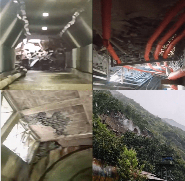
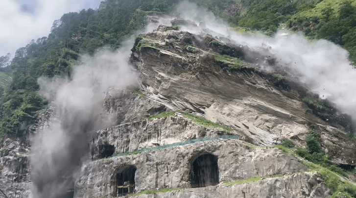
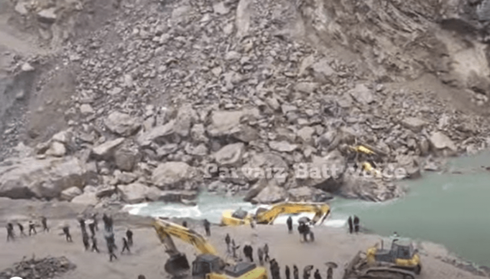
A landslide incident has partially damaged the power house tunnel of NHCP’s Dhauliganga HEP in Pithoragarh district of Uttarakhand. The incident occurred in the evening of Aug 30, 2025 after heavy rainfall also blocked the mouth of underground tunnel with rocks and debris. The HEP is built on Dhauliganga river in Dharchula tehsil of the district.
Continue reading “Aug 2025: Landslide Damages NHPC’s Dhauliganga HEP in Uttarakhand”Category: Landslide
Aug 2025: Rockslide at Vishnugad-Pipalkoti in Uttarakhand
(Feature Image: Rockslide at dam site of 444 Mw Vishnugad-Pipalkoti HEP on Aug 02, 2025)
At least 12 workers sustained injuries in a rockslide at the under construction Vsihnugad-Pipalkoti Hydro-Electric Power (VPHEP) project in Chamoli district of Uttarakhand. The 444 Mw (111X4) project is being built on Alaknanda River by the Tehri Hydro Development Corporation (THDC).
Continue reading “Aug 2025: Rockslide at Vishnugad-Pipalkoti in Uttarakhand”A Sinking Village & a Stream that Floods in the Sun: Climate Change, Jahlma Nallah and Lindur in Chenab Basin
At the village of Jasrath in Lahaul and Spiti, the River Chandrabhaga’s current is swift and strong like a rambunctious toddler. The river is new here, birthed just 16 kms upstream at the confluence of the Rivers Chandra and Bhaga. Chandrabhaga will be named as Chenab only after a journey of about 400 kms downstream. Chenab is one of the largest tributaries of the River Indus whose expansive basin feeds over 250 million people in the heart of Asia.
Lahaul and Spiti district in Himachal Pradesh is a cold desert with very little rain, but the narrow ribbons of land along the Chandrabhaga are emerald with willows, apple orchards and cultivated farms. This is precious land.
Continue reading “A Sinking Village & a Stream that Floods in the Sun: Climate Change, Jahlma Nallah and Lindur in Chenab Basin”Aug 2024: Massive Landslide damages NHPC’s Teesta V Hydropower station
A massive landslide (location: [27.2515, 88.4594]) at Dipu Data near Singtam in Gangtok district that brought down a huge part of a hill above the power house of the NHPC’s 510 MW Teesta V hydropower project on Teesta river in Sikkim at 7.30 in the morning of Aug 20 2024 has damaged the power house. The GIS building above the underground power house located at Balutar can be seen getting destroyed in the massive landslide and getting buried under the debris. The project has been out of operation since the Oct 4 2023 GLOF disaster in Teesta river[i] had over topped the dam and seriously damaged the project.
Continue reading “Aug 2024: Massive Landslide damages NHPC’s Teesta V Hydropower station”Landslides in Kodagu & Western Ghats: A critique of GSI report
Guest Article by Prof Mysooru R. Yadupathi Putty
Introduction This write-up is with regard to the news-paper reports on the “The Geological Survey of India (GSI) Report on the landslides in Kodagu”. This is based on the information furnished by the news-papers and by the scanned copies of the original report of the GSI. The report attributes the landslides to excessive rainfall and extensive slope modifications due to anthropogenic activities, and puts blame on the people who have been using the land to their benefit. This brief article is written in order to bring it to the notice of the authorities concerned, and the people in general, that some of the observations of the GSI are highly ill-conceived, mutually contradictory and technically unsound. They unnecessarily go to rake up untoward feelings and create an impression that the people of Kodagu (Karnataka’s ‘Male-naadu’, in general) responsible for pulling the wrath of the Nature on to themselves. The author of this critique is a Hydrologist, who has been working in the region on Runoff processes, Land-use and Soils for nearly three decades. The following is a review of the available material of the report, point by point. Continue reading “Landslides in Kodagu & Western Ghats: A critique of GSI report”
JAJRED perennial landslide in Yamuna basin, Uttarakhand
Banner image Jajred landslide zone which just reactivated with commencement of monsoon rains. (Nishant Panwar, July 07, 2020)
Come monsoon and the Jajred mountain in Kalsi tehsil, Dehradun district in Uttarakhand starts falling apart. Located about 11 km away from Kalsi town, the landslide site near Amraha village blocks the vehicular movement on Kalsi-Chakrata state highway running through the zone for weeks sometimes for months.
This is a routine affair during monsoon for past many years damaging about 250 metre road stretch frequently thus cutting off the hundreds of villages in Jonsar-Bawar area from tehsil and state capital.
Continue reading “JAJRED perennial landslide in Yamuna basin, Uttarakhand”
Landslide in Sikkim damages NHPC’s Teesta V Dam Project
This photo is possibly the worst advertisement for a hydropower project with landslide rocks sitting on top of the dam. A massive landslide has severely damaged the 55 m high dam of the 510 MW Teesta Hydropower Project of NHPC, at 00.20 hours on June 27, 2020. This is a major blow to NHPC, considered India’s premier hydropower company. It’s also a major blow to the propaganda of International Hydropower Association, falsely pushing this very project as an example under IHA’s Hydropower Sustainability Assessment Protocol[i].
NHPC PR on June 28 afternoon said the landslide happened “at Dam Axis on left abutment hill side from a height of about 40 meter from Dam top NHPC Teesta-V Dam at Dikchu, East Sikkim. The access to Dam Control Room (DCR) as well as electrical connection to Dam top was cut-off due to this slide.” The electricity supply was restored about 9 hours later. (https://www.facebook.com/1764846020501239/posts/2689927154659783/)
Continue reading “Landslide in Sikkim damages NHPC’s Teesta V Dam Project”
Why Jammu-Srinagar Highway Is So Landslide Prone?
Finally, after five days gridlock, the Jammu-Srinagar National Highway (NH-1A) has been opened to traffic, on Feb 17, 2018, but only for one side. The all weather road was closed since February 12, 2018 following landslides at multiple locations along Bichleri (Bichiari) stream (a tributary of Chenab River) between Banihal and Ramban area. The highway was briefly re-opened for traffic on February 14 only to be closed again on February 15, due to recurring landslides.
We have narrated below some details of the landslides along Jammu Srinagar Highway in Feb 2018 as well as earlier since 2011.
Continue reading “Why Jammu-Srinagar Highway Is So Landslide Prone?”
Who exactly needs the Pancheshwar Dam?
“Bolo Jai Jai Baba Bhole”, the Prime Minister Narendrabhai Modi, while speaking at Kedarnath in Uttarakhand in Oct 2017[i], asked the people in audience to chant with him. Indian deity Mahadev, the presiding deity at Kedarnath on the banks of Mandakini river is possibly the closest to rivers and nature among all the deities, as is also clear from his attire. Baba Bhole is one of the many names of this deity. Incidentally, the massive, controversial Pancheshwar Dam a pet project of Mr Modi will also submerge the Pancheshwar Mahadev Temple, where too, the presiding deity is same Bhole Baba. But we will come back to Bhole Baba. Continue reading “Who exactly needs the Pancheshwar Dam?”
Yamuna fighting existential battle in the homeland as Govt. speeds up construction of dams

Contrary to common mindset that Yamuna River is still flowing pristine in Himalaya, an exploratory visit (23-27 June 2015) inside Yamuna Valley underlines that construction of 120 MW Vyashi Hydro Electric Project report, proposed 300 MW Lakhwar dam and Katapathar Barrage is compromising the existence of the special river in its very homeland. The report also highlights that the river stretch where all these projects are coming up is prone to large scale landslides. It was also found that downstream community is unaware of environmental flow and the project developers are tight lipped on impact these projects over aquatic biodiversity. Road expansion work upstream these projects is dumping tonnes of debris into river, in complete violation of all norms (neither state nor central government seem bothered about these violations by the government agencies) further lifting up the already escalated riverbed. The perennial natural springs are gradually drying up in the area. Impact of all these impacts and threats on River Yamuna and riparian community still remain unstudied and unaddressed.