Finally, after five days gridlock, the Jammu-Srinagar National Highway (NH-1A) has been opened to traffic, on Feb 17, 2018, but only for one side. The all weather road was closed since February 12, 2018 following landslides at multiple locations along Bichleri (Bichiari) stream (a tributary of Chenab River) between Banihal and Ramban area. The highway was briefly re-opened for traffic on February 14 only to be closed again on February 15, due to recurring landslides.
We have narrated below some details of the landslides along Jammu Srinagar Highway in Feb 2018 as well as earlier since 2011.

The 270 km long arterial National Highway (NH-1A[i]) connects Kashmir valley to the rest of India. In 2010, NH 1A was renumbered as NH 44[ii]. The Jawahar Tunnel[iii] linking Jammu with the Kashmir across Pir Panjal Range is on this route. In past, several new tunnels were planned along the road. Among them, Chenani-Nashri Tunnel and new Banihal double road tunnel are reported to be commissioned.
Stretches of the highway ran through very precarious terrain[iv]. Hence, the blockage of NH has become a recurring phenomenon for past many years. In February 2018, there were reports of devastating landslides triggered after rainfall and snowfall.
The landslides were mainly at Panthyal, Ramsoo, Anokhifal, Nashri, Maroog, Battery Cheshma, Kheri along the Bichleri stream in Ramban district and Udhampur district. Bichleri joins Chenab downstream Ramban. Below is information from various news reports, throwing some light on magnitude of landslides, resultant impacts and possible reasons.

Following opening of one-way traffic towards Kashmir from Jammu, there was massive traffic jams and passengers remained stuck for hours. Meanwhile, a weather department official said there was a possibility of rain or snow in some areas in the next 24 hours. https://kashmirobserver.net/2018/local-news/highway-sees-gridlocks-28945 (Kashmir Observer, 17 Feb. 2018)
More than 2000 vehicles were stranded due to landslides and shooting stones from the hills along highway. Flight prices from Jammu to Srinagar also soared during 5 days long blockage. The Jammu and Kashmir Public Service Commission had to postpone the Combined Competitive (Mains) Examination scheduled for Feb. 15 and 17. https://scroll.in/latest/868798/jammu-srinagar-highway-closed-for-fourth-consecutive-day-after-landslides (Scroll.in, 15 Feb. 2018)
Hundreds of tourist stuck in the gridlock jam due to landslide block. They also complained of shopkeepers and hotel owners over charging them despite cash shortage. http://www.firstpost.com/india/jammu-srinagar-national-highway-remains-closed-for-fourth-consecutive-day-due-to-landslide-clearance-work-4352255.html (The First Post, 15 Feb. 2018)
Several vehicles stranded on the road including Ramban, Udhampur and Nagrota Bypass, whereas, power supply to entire Paddar-Gulabgarh Sub Division and many other areas could not be restored even after third day of the rain and snowfall.
Due to fresh landslide at Kheri about, 7 kms ahead of Udhampur on February 15 morning and landslides at Anokhi Fall, Battery Chashma Marog the Jammu-Srinagar National highway remained closed. The highway near Udhampur was cleared but due to another fresh land slide near Ramsoo (Maroog) same day, was again blocked. A low-danger avalanche warning was issued for Anantnag, Ramban, Ganderbal, Kargil and Leh districts. People in the avalanche prone areas were advised not to venture out. http://www.dailyexcelsior.com/nh-remains-closed-on-3rd-day-over-2000-vehicles-stranded/ (Daily Excelsior, 15 Feb. 2018)
Fresh landslides at Maroog in Ramban district left the commuters high and dry. The closure created problems for local people paralyzing the social life. Hundreds of passenger vehicles were stopped at Ramban and Udhampur and not allowed beyond Khow Bagh crossing naka outskirts of Ramban by the police. http://www.greaterkashmir.com/news/state/ramban-landslides-leave-commuters-in-lurch/275816.html (The Greater Kashimr, 15 Feb. 2018)

Here are some video reports showing the scale of devastation caused by the landslides
https://www.youtube.com/watch?v=AT46QAOT68k (Zee News, You Tube, 14 Feb. 208)
“The digging work of under-construction four-lane highway along existing road at the bottom of steep mountains is the main cause of landslides and shooting stones between Nashri and Banihal,” said a commuter, Farooq Ahmed Lone.
He said, “There are dozens of places between Ramban to Banihal and Udhampur to Ramban where digging work is on. Instead of taking up digging work in haphazard manner the contractor companies should have done it in a phased manner. It seems these companies have ignored the safety part and have no plan ready to tackle the weather vagaries.”
An official said, “There are more than 15 active landslides and shooting stone spots on the highway from Ramban to Udhampur. The stretch between Ramban and Ramsoo sector is prone to worst landslides and fatal shooting stones.”
An expert said, “Continuous rainfall can trigger heavy landslides on the highway between Ramban-Bahihal and Chenani–Udhampur and can stop traffic movement for weeks together.” http://www.greaterkashmir.com/news/kashmir/contractor-companies-blamed-for-making-highway-vulnerable/275869.html (Grater Kashmir, 15 Feb. 2018)
The 270 km arterial road, the only all weather link between the valley with the rest of the country, was closed for vehicular traffic after various parts of the highway including Jawahar Tunnel – the gateway to Kashmir – experienced about two feet of snowfall.
Snowfall, coupled with incessant rain triggered the landslides at several places including Panthyal, Ramsoo and Anokhifal, forcing the closure of the highway, leaving over 800 trucks and passenger vehicles stranded. http://www.business-standard.com/article/pti-stories/jammu-srinagar-national-highway-reopened-for-traffic-118021300724_1.html (Business Standard, 13 Feb. 2018)
EARLIER LANDSLIDE INCIDENTS ON JAMMU-SRINAGAR HIGHWAY IN RAMBAN
Feb 2018 The highway was also closed on Feb. 6 due to a landslide near Magarkote in Ramsu, Ramban district. Traffic remained suspended for the major part of the day and vehicles and passengers were stuck on the highway. http://www.tribuneindia.com/news/jammu-kashmir/j-k-highway-closed-after-landslide-in-ramban-300-vehicles-stranded/539616.html (The Tribune, 6 Feb. 2018)

The landslide was reportedly triggered at a construction site, where the conversion of the road from the existing 2-lane to 4-lane is under progress. http://www.greaterkashmir.com/news/chenab-valley/landslide-on-jammu-srinagar-highway-debris-cleared/274919.html (Greater Kashmir, 7 Feb. 2018)

Dec 2017 A landslide hit a road construction site in the Ramban district, killing one person while another went missing. The landslide occurred near Seri-Seencha village during the construction of a link road, trapping a worker and a civilian passerby. http://indianexpress.com/article/india/jk-landslide-one-dead-another-person-buried-under-debris-as-police-launch-rescue-efforts-4966364/ (The Indian Express, 3 Dec. 2017)
Sept 2017 Traffic was suspended after a massive landslide blocked the arterial road and also damaged a bridge in Udhampur district. The landslide struck the national highway at Morh Passi near Balli Nallah damaging a bridge and blocking the road. Hundreds of vehicles got stranded. http://www.greaterkashmir.com/news/jammu/landslide-blocks-jammu-srinagar-highway-bridge-damaged/260031.html (Greater Kashmir, 12 Sept. 2017)
July 2017 The highway was closed due to landslides caused by heavy rains at Kheri near Udhampur and Ramban. http://www.dailyexcelsior.com/3-killed-heavy-rains-paralyse-life/ (Daily Excelsior, 18 July 2017)
March 2016 Two persons were killed and three others sustained grievous injuries after a Jammu-bound Sumo taxi skidded off road and plunged into the turbulent Bisleri Nullah at Gangroo in the Ramsu area of Ramban district. The Doda and Kishtwar districts remained cut off from rest of the state after a massive landslide at the Raggi Nullah blocked the only road link to the twin districts. http://www.tribuneindia.com/news/jammu-kashmir/2-killed-3-hurt-as-rain-triggers-landslides-in-jammu-region/210312.html (The Tribune, 17 March 2016)

The police officials of Ramsu also had narrow escape while a constable was injured when shooting stones hit police vehicle who had gone to supervise rescue operation. Hundreds of vehicles, including those carrying essential supplies, were standard on both sides of the highway near the Raggi Nullah. http://www.dailyexcelsior.com/4-killed-3-missing-as-landslides-hit-sumo-in-ramban-vehicle-slips-into-gorge-in-doda/ (Daily Excelsior, 17 March 2016)
Oct 2015 The highway closed to vehicular traffic following landslides in Ramban district which were triggered by heavy rain in Ramsoo sector. Snowfall in Pir Ki Gali area of the ancient Mughal Road also suspended the surface link between the valley and Rajouri district. http://www.business-standard.com/article/current-affairs/landslides-in-ramban-district-close-jammu-srinagar-highway-114041900353_1.html (Business Standard, 26 Oct. 2015)
2014 Video showing the landslide damaging the road in Ramban district.
Feb. 2013 There was disruption of traffic due to landslides blocking the highway in Ramban area. http://www.kashmirtimes.in/newsdet.aspx?q=26055 (Kashmir Times, 16 Feb. 2013)
The highway remained closed following continuous snowfall between Patnitop to Ba-nihal and the landslide and stone shooting made the condition worst at Seri, Kela Morh and Panthal at district Ramban. http://www.earlytimes.in/newsdet.aspx?q=103837 (Early Times, 4 Feb. 2013)
Feb 2012 Landslides and shooting stones blocked the highway. There were landslides in Panthal and Khoni Nallah areas and fresh snowfall in Bannihal and Patnitop sectors and Ramban areas the most accident prone stretch of the highway.
A landslide tragedy on the NH 44 killed seven passengers and two more in the Khoni Nallah area. Incessant rains often loosened the soil triggering landslides and shooting stones in Panthal, Khoni Nallah, Anokhi Fall and Ramban sectors. https://www.indiatoday.in/india/north/story/landslides-block-srinagar-jammu-highway-93849-2012-02-22 (India Today, 22 Feb. 2012)
2011 A security guard was killed while 26 workers rescued after flash floods ripped through Banihal area of Ramban following a cloud burst in the adjoining Doda district. The workers, employed at Baglihar Power Project, were safely evicted from an approach tunnel but 1 person was killed after being hit by a boulder. The cloudburst affected over a km stretch of the Doda-Batote highway, and many vehicles and people were left stranded in the region. http://archive.indianexpress.com/news/1-killed-26-rescued-after-flash-floods-hit-banihal-area/801478/ (The Indian Express, 9 June 2011)

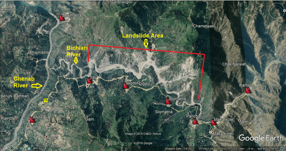
In Conclusion We have narrated here some details of the landslides along Jammu Srinagar Highway in Feb 2018 as well as earlier since 2011. This shows that the Highway next to the Bichleri River is prone to landslides and the incidents have also increased due to work related to 4-laning of the 2-lane highway. However, it needs to be noted that many of the landslide sights are on western side of the Bichleri River, while the Highway is on the Eastern side of the River. The narrative above provides impacts of only a small part of the landslides that affect the Highways, but does not include the impacts of landslides on other side of the river.
A massive 1856 MW Sawalkote Hydrpower project is proposed[v] on Chenab river, downstream of the confluence of Bichleri River with Chenab. The reservoir of the project (involves 192.5 m high dam, 1159 ha reservoir with 530 million cubic meters of storage capacity) is likely to extend into this landslide prone zone, but the EIA of the project is mostly silent on this issue. In fact the Sawalkote project is only one of the large cascades of hydropower projects[vi] existing, under construction and planned along Chenab River in India.

We definitely need a study that in the first place puts together full information about the extent of the landslides that are happening on both sides of the river along the entire affected area. Secondly, we need to analyse the reasons for these frequent landslides and their implications. And lastly this should be basic information before any major intervention is taken up in the area. It should also be kept in mind that this is also seismically active area, besides being prone to landslides and floods, including flash floods.
A 3D google earth video of the area.
Compiled by Bhim Singh Rawat (bhim.sandrp@gmail.com)
[i] https://en.wikipedia.org/wiki/National_Highway_1A
[ii] https://en.wikipedia.org/wiki/National_Highway_44_(India)
[iii] https://en.wikipedia.org/wiki/Jawahar_Tunnel
[iv] https://en.wikipedia.org/wiki/National_Highway_1A
[v] https://sandrp.wordpress.com/2016/01/14/open-letter-to-jkspcb-cancel-public-hearings-for-sawalkote-hep-for-violations/
[vi] See a map of the Chenab basin that shows some of them: https://sandrp.in/basin_maps/Hydro_%20Electric_Projects_in_Chenab_River_Basin.pdf
