Guest Article by Prof Mysooru R. Yadupathi Putty
Introduction This write-up is with regard to the news-paper reports on the “The Geological Survey of India (GSI) Report on the landslides in Kodagu”. This is based on the information furnished by the news-papers and by the scanned copies of the original report of the GSI. The report attributes the landslides to excessive rainfall and extensive slope modifications due to anthropogenic activities, and puts blame on the people who have been using the land to their benefit. This brief article is written in order to bring it to the notice of the authorities concerned, and the people in general, that some of the observations of the GSI are highly ill-conceived, mutually contradictory and technically unsound. They unnecessarily go to rake up untoward feelings and create an impression that the people of Kodagu (Karnataka’s ‘Male-naadu’, in general) responsible for pulling the wrath of the Nature on to themselves. The author of this critique is a Hydrologist, who has been working in the region on Runoff processes, Land-use and Soils for nearly three decades. The following is a review of the available material of the report, point by point.


Recent landslides – What are They Due to?
Citing reasons for the landslides on 16th and 17th August 2018, the GSI writes as below:
“High angle slope cut for road construction, rapid slope modification for construction of houses, hotels, home-stays and large scale slope modification for coffee plantation are very common. These slope modifications actually decrease slope stability and later with the high rainwater percolation the slopes become unstable and prone to failure.
“Due to slope modifications natural drainage has been blocked. But, during high water precipitation in Monsoon, huge volume of water flowed from upslope towards downslope …… . But as water volume kept on increasing, the water pressure on the surface got so intense that it could not hold water resulting in slope failure ….”
The GSI goes ahead to suggest long-term measures to prevent landslides as this:
“Construction of drainage system on slope to reduce the pore pressure, construction of retaining walls, stone pitching and gabions, biotechnical measures of slope protection and modification of slope by grading and benching. “ Plantations like Vetriver grass may be planted which is the best means to improve the slope stability conditions.”
Supposedly, the GSI suggests measures to reduce surface flow and increase infiltration through land management practices. On the other hand, the report explains yet another cause for landslides thus:
“Another reason is the creation of water tanks and ponds built in estates ……. , some are created even on higher slopes modifying the actual slope. During the heavy rainfall, all these got overflowed. There are also high possibilities of seepage from within the tanks directly within the slope. This water along with rain water will increase the pore water pressure of the slope and decrease the internal friction of the slope forming material which ultimately lead to the slope failure.”
Obviously, the above few observations contradict each other and are misleading. One fails to understand whether the agency recommends measures to increase seepage (infiltration) and thus reduce overland flow or vice-versa! In the recent decades, the Country has been witness to a revolution that has promoted rainwater harvesting and watershed development in a big-way. This revolution has swept through the Male-naadu areas also – creation of new tanks, aforestation (with exotic species) of slopes that probably had never seen even a small tree growing on them, implementation of land management practices even on pristine grassed slopes, etc. have battered the Western Ghats no end. All these measures have been taken up just to increase infiltration, and now the GSI blames the people for increasing seepage by artificial means!!


Where Do Landslides Occur?
Describing where landslides occur, GSI writes:
“the causative factors for these landslide incidences are mainly anthropogenic i.e. destabilisation of slopes by removal of toe, lack of proper drainage at toe part and on the slopes causing seepage of water into the weaker planes like joints and fracture. The triggering factor for slides in the study area is mainly rainfall which has contributed to increase in the pore pressure of the weathered rock mass resulting in reduction of shear strength and subsequent failure.
“Most of the slides of the area are occurring in in-situ soil/ Laterite/ weathered rock as overburden on slope.
“Most of the slides were recorded on modified slope along road sections”.
The report quotes many previous studies and mentions remedial measures thus:
“Realignment of the road, construction of retaining wall with back filling and stone pitching for the downslope at 1:1 angle, removal of slide debris and arresting infiltration of water at the top with proper concrete lined drainage was recommended.
“Removal of overburden material, slope benching, proper lined drainage at the top as well as the toe …..
“The design of the retaining structure should be made as per standards keeping in view the strength parameter of the rocks (granite gneiss) in the area. Weep holes are to be provided to retaining structures with suitable graded filters”.
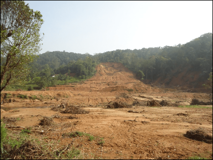
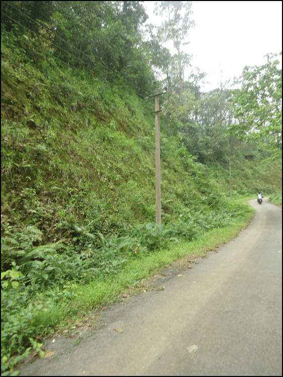
It is learn that the GSI team visited 85 of the 105 sites that experienced landslides. It is surprising and shocking that the team of experts failed to understand the very simple truth that these landslides in Kodagu have not been rock falls, but are rather a mass sliding of soil mantles, which are extraordinary thick in this region (Borugeon, 1989). The soils formed on site here are more than 20 m thick on most slopes and are thicker than 50 m in some places (Darshan, 2016). Hence, Joints and Fractures in rocks play absolutely no role in these landslides. It is also a pity the team failed to notice that mass sliding has occurred mostly in the valley portions (Plate 2) and that many vertical cuttings away from the valley have sustained (Plate 3).

This author is sad that the GSI delves not even a bit on the soils and their characteristics in the region. The fact is that the Western Ghat slopes are highly stable (Putty and Madhusoodhanan, 2013), since over the whole of the region hardly 20% of the rainfall flows over-land and on the forest floors, the complete amount of rainfall infiltrates in to the ground (Putty, Swamy and Prasad, 1997). The so infiltrating water flows into the streams through subsurface pathways. This subsurface flow, while reaching the streams in the valleys saturates large masses of soil in the vicinity of the stream. Hence, the valley portions are always prone to sliding, and exceptionally heavy and continuous rains lead to disastrous sliding. The rain gauge being maintained by the ‘Water Resource Centre’ of the National Institute of Engg., Mysuru, at a place near the areas of massive sliding, has recorded 320 mm, 461 mm and 394 mm of rainfall on the 14th, 16th and 17th respectively, while the previous 5-day rainfall had been 880 mm. This extremely heavy rainfall has led to unprecedented subsurface water storage and the obvious has happened. It may be noted that slope protection works of no sort would prevent slides of this order in the valleys. As has been the experience of the Indian Railways, landslides in the valleys only wash away all sorts of protection works and the only way to prevent frequent occurrences of slides would be to totally avoid tall cuttings near the valley portions.
Hydrology of the Western Ghats
Little is known to the common man of the hydrological processes and soils in Male-naadu. Even experts, who are familiar only with regions that experience much less rainfall and are underlain by only sedimentary rocks, fail to understand the situation in Kodagu. A couple of examples can be mentioned. Dr. Balasubramanian (an expert, who has guided many students to their Ph.D. in landslips), whom ‘The Hindu’ interviewed in the wake of the Kodagu disaster has been quoted to have said so:
“…. based on the output, an area can be classified under the high-risk or the low-risk category for landslips. Normally such a study is done along railway tracks but not in an urban environment. But it is a must for a hilly terrain like Kodagu especially in areas where the thickness of soil is in excess of 1.5 metres. Soil thickness in excess of 1.5 metres always has an element of uncertainty”.
But, here in the Western Ghats, the soils are thicker ten times that! The team from IEI, Mysuru, is reported to have written so: “implementation of the Kasturi Rangan panel report would have prevented the disaster”. One should not even dream of any effect on landslides due to implementation of any measure for just a couple of feet deep at the surface. This is so since soils in the region have formed over millions of years and the slides have occurred meters deep in soils. Be that, however, it is a sad state of affairs that a high level committee appointed for the purpose ignores the hydrological processes that actually prevail in the region, while preparing an ‘authentic report’.
At yet another point, the GSI team writes:
“Clean water flow in force from inside the slope: It was observed that considerable volume of very clean water was coming out from the middle parts of the landslides. These may be caused due to high amount water flux in aquifers…….
“Another probability may be the water percolated inside the rock joints in one place and travelled through the joint planes before coming out at some other places. Whatever might the reason be, this continuous flow of the water in force inside the slope will decrease the stability of the slope and eventually will act as a triggering factor for slope failure”.


This confirms the total ignorance of the GSI team of the runoff mechanisms in wet mountainous areas, our Male-naadu in particular. Investigations over the region by the author of this critique (Putty, 1994; Putty and Prasad, 2000), during a period of over two decades, have established that subsurface flow in the wetter parts of this land takes place through soil pipes, which form a very good means of draining the soil mantle quickly and keeping it stable. The Western Ghat areas are locally called Sahyadris, which interestingly mean “hills of tolerance”. These mountains have stood the odds of extreme rainfall mainly because of the presence of preferential subsurface pathways like pipes, which this author likens to Gupta Gaminies (Plate 4).
Unfortunately, the GSI and other teams seem to be ignorant of this very important “safety valve” of nature. This type of ignorance is the case even after the investigations on Pipeflow have been reported often (Putty, 2006, 2009) and the ‘National Centre for Earth Science Studies’, Thiruvananthapuram, has conducted a workshop on piping and has published reports on land subsidences in Kerala due to piping (Plate 5), the last year (Proceedings piping land disturbances 2017).


Nature and Man:
This write-up has been penned to emphasise on the fact that while human activities do have an impact on the natural processes, disasters cannot be prevented and that people cannot be held responsible for all sorts of disasters. Further, it is the intention of the author to highlight that the water-related issues in Male-naadu region are much different from those elsewhere and have to be viewed from angles different from the commonly known ones. Since surface runoff processes in the region are largely confined to the stream sides, human interference in these portions do disturb the natural processes greatly. Human interferences here not only mean those taken up for beneficial ends, but also include the so-called Watershed development practices and forced Afforestation. Such activities block the subsurface flow paths, damage the pipes and bring subsurface water to the surface. They lead to accelerated erosion and widen stream channels. Hence, they need to be curbed. However, small scale use of land by local inhabitants, taken up to heck-out at least a simple living, cannot be pointed out to be the reason for disasters. While clear cutting of slopes with thick vegetation to pave way for large scale plantations, particularly for tea and rubber (and coffee with canopy cover of ‘exotic species’), should be banned, unnecessary widening of roads and execution of new mega projects (like railways and river diversion schemes) should be done away with. But, human activities on smaller scales can only be modified, with proper guidelines, to avoid large scale impact on the natural system. Framing such guidelines calls for long and dedicated studies. In fact, studies on Hydrology and Pedology of the region have utmost been scanty. Hence, water and soil engineers should be encouraged to do extensive field research in the region.
It seems the only bright spot in the GSI report is that it mentions having selected a few landslides for detailed studies. This author hopes fervently that such studies will involve experts without preconceived ideas and will harness the local knowledge base.
Author Mysooru R. Yadupathi Putty (puttyyadupathi@gmail.com) is Professor, Dept. Civil Engg., The National Institute of Engg., Mysuru-570008
REFERENCES
- Borugeon G 1989 Explanatory booklet on the reconnaissance soil map of forest area: Western Karnataka and Goa; French Institute, Pondicherry, India : 95pp.
- Darshan R 2016 Some studies on hydrological properties of soils in the upland areas of the Gundia Basin; M. Tech. dissertation, The National Institute of Engg., Mysuru, India.
- Putty M R Y 2006 Salient features of the hydrology of the Western Ghats in Karnataka; In: Krishnaswamy J, Lele, S, Jayakumar, R (Eds.), Hydrology and Watershed Services in the Western Ghats of India, Tata-McGraw Hill.
- Putty M R Y 2009 A Curve Number based watershed model incorporating quick subsurface runoff, with applications in the Western Ghats, South India; ASCE J. Hydrol. Engg., 14 (8): 876-881.
- Putty M R Y and Prasad R 2000 Runoff processes in head water catchments – an experimental study in Western Ghats, South India J Hydrol 235: 63-71
- Putty M R Y, Swamy BKK and Prasad R 1997 A study on infiltration rates in a very wet zone of the Western Ghats Hydrol. Jour of IAH Vol 20, No1-4:1-17
- Putty R Y 1994 The mechanisms of streamflow generation in the Sahyadri ranges (Western Ghats) of South India; Unpub. Ph.D. thesis. I.I.Sc., Bangalore, India.
- Putty, M.R.Y. and Madhusoodhanan, C.G. (2013). “Water resources and hydrology of the Western Ghats: their role and significance in South India”. NNRMS bulletin of ISRO, , 2013: 57-66.
