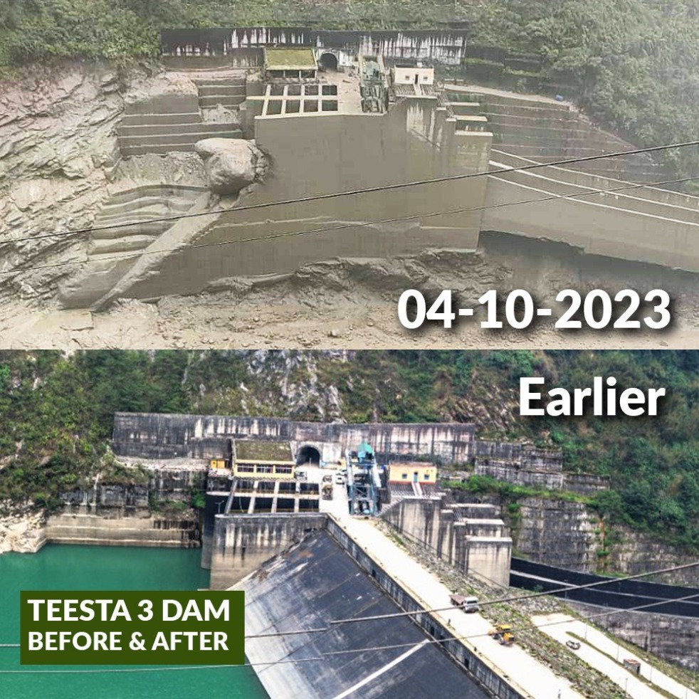
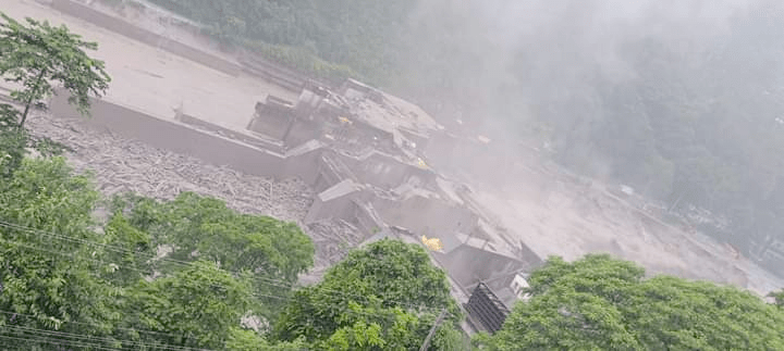
A Glacial Lake Outburst Flood (GLOF) that originated at South Lhonak Glacial Lake at around 00.40 hours on Oct 4, 2023, washed away the 60 m high dam of Sikkim’s biggest hydropower project, the 1200 MW Teesta 3 HEP. The flood has brought unprecedented disaster all along the river in Sikkim and further downstream in W Bengal and then Bangladesh. Central Water Commission (CWC) reported early in the morning of Oct 4 that there was cloud burst at the site of the lake burst, the cloud burst could have played the role in triggering the lake burst. (Feature image above: A combination of before after photos of Teesta 3 dam put together by Siddharth Agarwal.)

While the videos and photos of the washing away of the 60 m high (above river bed) Teesta 3 dam were coming since morning, it was formally reported only around 1 pm, almost 12 hours after the possible washing away of the dam. Visuals from the spot show large portions of the dam’s wall missing as the rising Teesta water flowed through it unabated in North Sikkim’s Mangan district.[i]
Teesta 3 Dam Chariman “The dam at Chungthang got washed away in ten minutes just after 12 midnight. We also saw that the 200-metre-long bridge connecting the powerhouse has been washed away. The entire powerhouse has been submerged under water.” said Sunil Saraogi, the executive chairman of Sikkim Urja Limited (formerly: Teesta Urja Limited). Saraogi said, “At 11.58pm on Tuesday, we got information from the Indo-Tibetan Border Police (ITBP). Immediately, our team went to the dam to open the gates. Before they could open, the flash flood hit them, and they ran away to save their lives. There were 12 to 13 people in the team and they somehow got saved on the other side of the dam and they would be evacuated by ITBP by 2 pm on Wednesday (Oct 4 2023). We are unable to reach the powerhouse. We don’t know the extent of damage in the powerhouse at Mangan. No one could reach the powerhouse as the bridge connecting the dam had gone. Fortunately, no one is inside the powerhouse as all have come out,” he said.
South Lhonak Lake is a glacial–moraine-dammed lake, located in Sikkim‘s far northwestern region. It is one of the fastest expanding lakes in the Sikkim Himalaya region, and one of the 14 potentially dangerous lakes susceptible to Glacial lake outburst flood (GLOFs).[ii] The lake is located at 5,200 m (17,100 ft) above sea level. It formed due to the melting of the Lhonak glacier. The lake is rapidly growing in size in an abnormally rapid manner due to the melting of the lake’s associated South Lhonak glacier and additional melt water from the adjacent North Lhonak and main Lhonak glaciers. The lake coordinates: 27°56′50.93″N 88°19′53.54″E. (The correct coordinates, we are told may be: 27°54’44.4″N 88°11’38.6″E.) Max Length: 1.98 km; Max width: 0.45 km, surface area: 1.26 sq km; Max depth: 79.24 m.

The lake had an area of 17.54 hectares in 1977. Later, the lake’s areal extent was determined using 1989, 2002, and 2008 temporal satellite data. Between 1977 and 2008, the lake’s surface area rose by 81.1 hectares. The lake possibly burst at 12.40 am.[iii] According to Sikkim State Disaster Management Authority, the water flowed out at the rate of 15 m/s.
2021 paper: https://www.sciencedirect.com/science/article/pii/S0169555X21001914#s0110, “Future Glacial Lake Outburst Flood (GLOF) hazard of the South Lhonak. Lake, Sikkim Himalaya”, Ashim Sattar et al. Conclusion: “Mapping infrastructure exposed to GLOFs in the Teesta valley shows that many settlements and assets located along the river channel at Chungthang are potentially exposed to future GLOFs, indicating the need to conduct a full environmental impact assessment and potentially undertake GLOF risk mitigation measures.” The studies highlight that the length of the glacier that is feeding the lake over the last 29 years has been reduced from 6.4 k to 5.1 km, while the overall glacier shrank by 0.96 sq km.
Could avalanche have caused GLOF? Satellite images released by India’s space agency on Oct 4 showed that Lhonak Lake more than halved in size after it flooded. The images also show a lot of ice floating on the lake surface, said Jakob F. Steiner, a fellow at the Kathmandu-based International Centre for Integrated Mountain Development (ICIMOD), part of the Himalayan University Consortium. “On the south of the Lhonak Lake there are steep slopes, glaciers as well, there is still snow. It could be that a chunk of either ice or unstable slopes has detached and dropped into the lake water,” Steiner said, adding that the images indicate something like this happened. This can create shockwaves across the water surface that would be enough to topple the lake’s dam, Steiner added, since the lake is up to 120 metres (395 ft) deep. (https://www.reuters.com/world/india/deadly-himalayan-lake-flooding-india-likely-caused-by-avalanche-2023-10-05/)
EWS was already being installed? The NDTV, quoting a Reuters report, said on Oct 6 2023 that the government was already in the process of installing an Early Warning System at the South Lhonak Lake. It says: “Scientists and government authorities were working on an early warning system for glacial floods at a Himalayan lake in northeast India when it broke its banks this week with deadly consequences. The first part of the system, a camera to monitor Lhonak Lake’s level and weather instruments, were installed last month, officials involved in the project told Reuters. If fully operational, the warning system could have given people more time to evacuate, scientists said. One scientist said glacial early warning systems can typically give residents a few minutes to an hour of notice. “It’s quite absurd, really,” said geoscientist Simon Allen of the University of Zurich who is involved with the project. “The fact it happened just two weeks after our team was there was completely bad luck”.
– He said they planned to add a tripwire sensor that would trigger if the lake was about to burst. That would typically be connected to an alert system or siren that would warn residents to immediately evacuate to higher ground. “The Indian government was not prepared to do that this year, so it was being done as a two-step process,” he said.”
– The early warning systems at Lhonak Lake, and another at nearby Shako Cho in Sikkim, were to be among the first in India for glacial lake outburst floods, sources told Reuters. Scientists have for years said the two lakes are at risk of outburst floods, but the design process and search for funding caused time to pass without progress.
Warnings ignored The first inventory of glacial lakes in the Sikkim Himalayas was made in 2003, with 266 lakes mapped and 14 of them identified as potentially critical. Similar studies were conducted in 2013 and 2017, and researchers repeated their warnings. “Strikingly, in all these studies, South Lhonak Lake was identified as potentially dangerous with a high outburst (sudden release of water) probability,” said Ashim Sattar, scientist, Divecha Centre for Climate Change, IISc, Bangalore. Sattar, who does modular computing too, published two papers — the latest in 2021 being a study of six avalanche scenarios leading to glacial lake outburst floods (GLOFs).
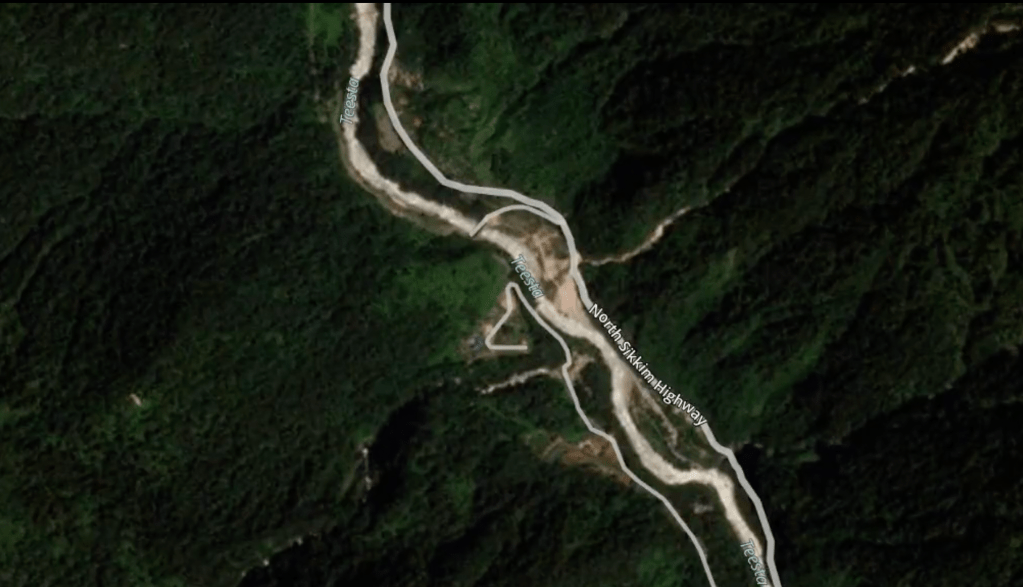
The South Lhonak Lake was identified as the fastest-growing lake in Sikkim, with its glacier receding by 2km between 1962 and 2008 and by another 400 metres between 2008 and 2019. “Water from the various lakes drain into the Teesta, which trickles from the Tso Lhamu Lake in north Sikkim. Water from the South Lhonak Lake first drains into the Goma channel, which then joins the River Zemu, 36km downstream of the lake. The Zemu further joins the River Lachen at Hema, about 40km downstream,” Sattar said.
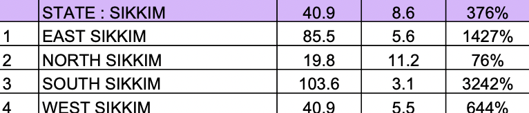
The Cloud Burst theory Initially, some officials including CWC persons talked about cloud burst leading to the floods, but even CWC officials now quoted by media are rejecting this. If we look at the rainfall reported in Sikkim in 24 hrs ending at 0830 hrs on Oct 4, 2023, as reported in IMD’s daily district wise rainfall, we see that it is not the North Sikkim (Mangan) dist that had the high rainfall but it was East Sikkim and South Sikkim:
Another theory being explored for further investigation is if the West Nepal (Bajhang dist) on Oct 3), but the highest magnitude earthquake (6.2) happened around 3 pm, whereas the GLOF happened past midnight. Let us see what conclusion the scientists arrive about this.
ISRO Tweets After 7.30 pm on Oct 4, 2023, someone tweeted images from National Remote Sensing Centre of ISRO about pre-disaster and post-disaster images of the South Lhonske Lake Burst.
This is useful, but can NRSC-ISRO provide such images as part of early warning to help manage such disasters, and at least take preventive steps?
Wide spread damage A statement by the Army’s Eastern Command has said some establishments along Lachen valley, upstream of Chungthang have been affected. “Release of water from the Chungthang dam led to a sudden increase in water level upto 15-20 feet high downstream. This has led to Army vehicles parked at Bardang near Singtam getting affected. 23 personnel have been reported missing and some vehicles are reported submerged under the slush. One of the 23 army personnel was subsequently rescued. Search operations are underway,” the statement said.[iv] The statement is slightly in error, since it was dam burst at the Chungthang dam (Teesta 3 dam) and not any controlled water release. A total of 14 bridges, including nine under Border Roads Org and five under state govt, have been washed away.
Around 14 workers working in Teesta 3 dam in Chungthang, parts of which were swept away, were still stranded in the tunnels till late evening on Oct 4.
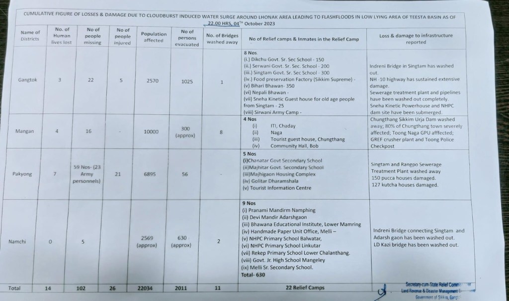
Sikkim State Disaster Dept Statement: The detailed account on Oct 4 2023 of Sikkim State Disaster Department about the damage is give below.
NDMA statement Late on Oct 4, 2023, National Disaster Management Authority came out with statement on this disaster, see below for the two page NDMA Press Release.

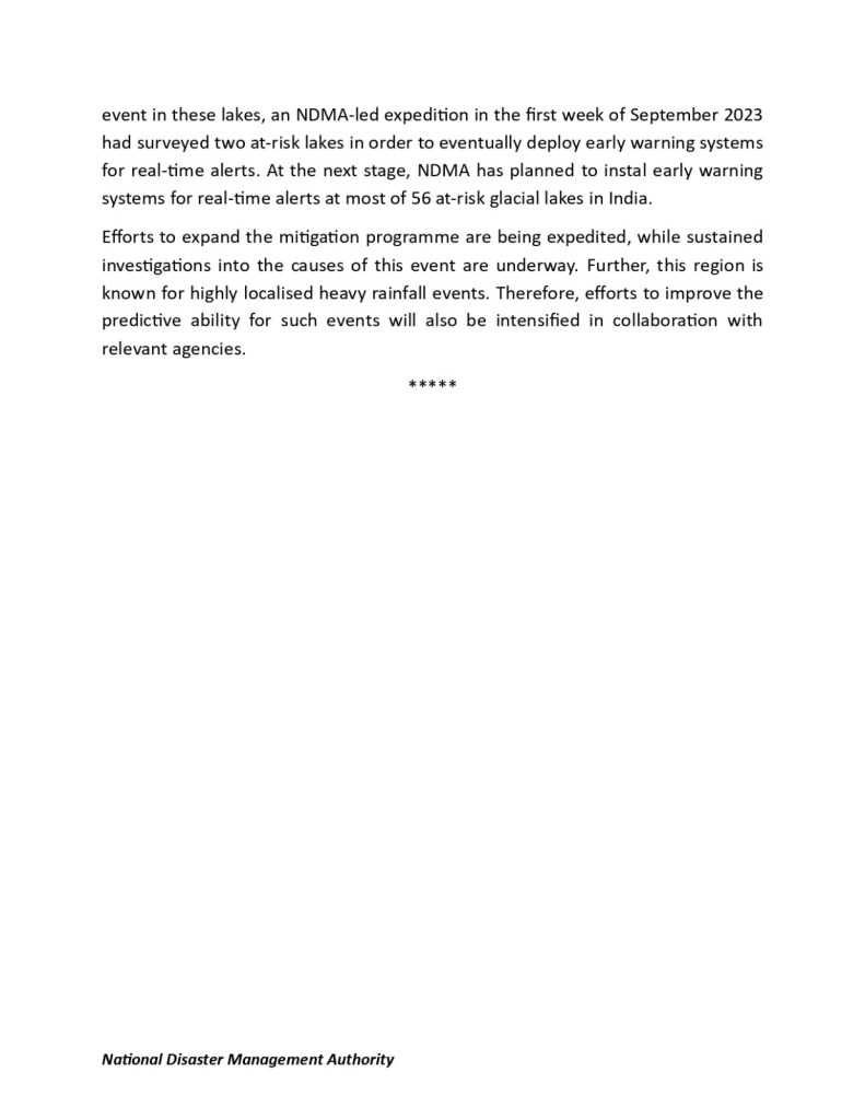
Interestingly, NDMA statement says that CWC’s monitoring station at Sankalang showed water level surge of 19 m above maximum water level at 0130 hours on Oct 4 2023. However, the hydrograph of Sankalang station downloaded from CWC website even on Oct 5 shows no reading after 10 pm on Oct 3, 2023. So how was NDMA getting the readings when CWC’s flood forecasting site has none?

Some details of the damage Chungthang is about 90 km north of Gangtok. As per the defence ministry, two bridges were also damaged in Dikchu and Toong towns connecting Singtam (30 km from Gangtok) to Chungthang in North Sikkim.[v] “Low lying areas such as Gazoldoba, Domohani, Mekhaliganj and Ghish may be affected. Please be alert,” the Sikkim weather office said.
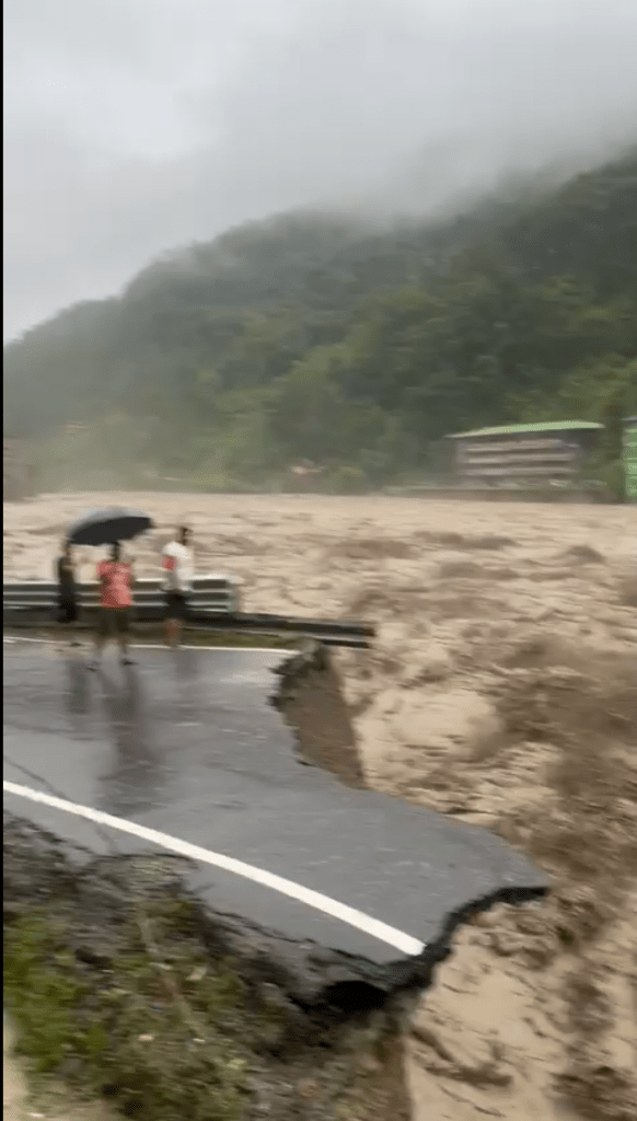
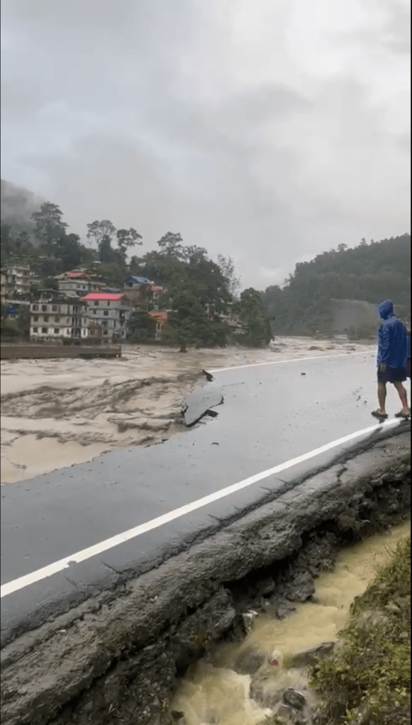
Connectivity to Sikkim, including capital Gangtok, has been affected flooded Teesta river washed away parts of NH-10 that connects the state to the rest of the country. “The flash flood made its way through River Teesta sweeping Indreni Bridge in Singtam town. A connecting bridge of the Balutar hamlet was also swept away around 4 am,” the Gangtok District Administration said.[vi]
Some further sad news[vii]: Four fatalities reported in Golitar and Singtam.
– Seven individuals reported as missing in Baghey Khola.
– Three people currently missing in Majitar.
– Seventeen people with minor injuries receiving treatment at Singtam District Hospital.
– Two laborers swept away in Mamring.
– Severe damage to the Sewerage Treatment Plant in Melli, Namchi District, as per the state government’s report.
– One individual reported missing from the NHPC Teesta site area.
– One person admitted to STNM/Gangtok hospital with severe injuries, as per the state government’s press communique in Gangtok District.
Some further details of damage from State Disaster Management Authority:
Mangan District: Chungthang cut off due to the Toong Bridge collapse. Phidang Bridge, both old and new collapsed. Four pucca houses at Phidang were washed away. Two houses at Dikchu were washed away. Houses along the river line are in danger, and two GREF labourers are reported missing at Sangkhalang, as per information received from GREF sources and one person missing from Phidang.
The GREF Crusher Plant and Old Police Barrack have been washed away at Toong, and four people have been reported missing.
Forest Guest House and two units of government quarters at Sangkhalang has been swept away.
(ii) Gangtok: Four injured have been taken to Singtam Hospital. 25 people have been rescued by SDRF, more rescue is underway.
(iii) Namchi district: LD Kazi Bridge washed away. Indreni Bridge washed away. A relief camp was set up at Namphing Sai Mandir. As of now, 500 people have been kept in the relief camps, and permanent relief has been set up at Pranami Mandir.
(iv) Pakyong district: Pakyong in east Sikkim, in the foothills of the Himalayas, has reported the most deaths – seven. As many as 59 people are missing in the district; these include the 23 Army personnel.
ZEEMA-III and BSD Bridges have also been destroyed.
W Bengal: As Teesta flows downstream from Sikkim to Bengal, sludge has entered homes near the state border. In Teesta Bazaar area in Bengal’s Kalimpong district, the swollen river has deposited sludge in homes and damaged trees in its course. In some homes, sludge had filled up almost an entire floor. Many homes closer to the bank have been washed away.
Damage to hydropower projects The central government on Oct 5 2023 said it will make a detailed assessment of damage to hydropower projects in Sikkim after the flood water recedes. The NHPC is taking all possible measures to get the hydropower projects operational at the earliest, the Power Ministry said. Power Secretary Pankaj Agrawal held an emergency meeting on Wednesday (Oct 4) with NHPC, where senior officers of the ministry and Central Electricity Authority were also present. Due to flash floods in the Teesta basin, all the bridges downstream to Teesta-V hydropower station up to Tarkhola and Pamphok have been submerged or washed away. The floodwater overtopped the dam of Teesta V power station (510 MW). All connecting roads to the project sites as well as parts of the residential colony have been severely damaged.
THE POWER MINISTRY STATEMENT on Oct 5, 2023: The Power Ministry is continuously monitoring the situation arising out of flash floods in Teesta Basin in Sikkim. Shri Pankaj Agrawal, Secretary (Power) held an emergency meeting yesterday with NHPC wherein senior officers of the Ministry of Power and Central Electricity Authority were also present.
Due to flash floods in the Teesta Basin in the intervening night of 3rd and 4th October 2023, all the bridges downstream to Teesta-V Hydropower Station upto Tarkhola/ Pamphok have been submerged/ washed out thus severely affecting commutation and communication in these areas. The flood water over topped the Dam of Teesta V Power Station (510 MW). All connecting roads to the project sites as well as parts of residential colony have been severely damaged. Presently, the power station is under shutdown and not generating electricity. NHPC had timely evacuated the manpower on all its projects and ensured that they are shifted to safer places. However, one casualty is reported from Teesta V power station.
Ongoing works of under construction hydro project Teesta VI (500 MW) of NHPC have been disrupted. The flood water had entered into power house and transformer cavern. Bridges connecting right and left banks at the barrage as well as Power House have been washed out. Two crane operators working at the project site are reported missing. All efforts are being made to trace them.
No major damages have been observed in TLDP-III (160 MW) (Teesta Low Dam – III Hydropower Plant) and TLDP-IV (132 MW) power stations located in the downstream West Bengal state. Both the power stations are safe but kept in shut down condition due to heavy siltation brought along with the flood water.
The quantum of damage at all the projects sites will be assessed in detail after the water level recedes. (https://pib.gov.in/PressReleasePage.aspx?PRID=1964825)
TEESTA 5 DAMAGED: The control room of the Teesta V dam near Dikchu has been severely damaged. The release of water from Dikchu was informed almost 1 and a half hours after the lake burst. So if lake burst happened at 12.40, the release of water from Dikchu possibly happened at 2.10 am. Design spillway capacity of Teesta 5 Dam: 12500 cumecs.
Teesta 4 dam is proposed between Teesta 3 and Teesta 5, dam, its work is yet to start as it does not have all the clearances. Let us hope that dam will not be taken up. Teesta 6 dam, earlier owned by LANCO and now transferred to NHPC, is under construction downstream of Teesta 5 project. Its under construction portions close to river are also likely to face damages.
Further downstream, the raging river water also swept away sections of the National highway (NH-10) in Melli, a border town of Sikkim-West Bengal. There are Teesta Low Dam III and IV of NHPC in W Bengal downstream from Sikkim and these projects are also likely to face the floods. One of the bridges in this area has already been washed away.
Teesta 6: Debris and damage The under construction Teesta 6 project, now under NHPC, was filled with debris and apparently damaged.
Teesta 3 dam key features: Gross capacity: 5.08 MCM, Live Capacity: 3.33 MCM, 400 m downstream of confluence of Lachen Chu and Lachung Chu. FRL: 1585 m. It is a Concrete Face Rockfill dam.

Shockingly, CWC’s National Register of Large Dams[viii] do not even list this dam! Similarly, CEA’s (Central Electricity Authority) compilation of salient features of hydropower projects in India does not even mention the spillway capacity of the project![ix]
It has two bays of chute Spillway on the Left Bank. “The 11m diameter and 1300m long flushing tunnel have been provided for reservoir flushing to maintain the long-term live capacity of the reservoir. The diversion tunnel 10m dia about 1km long has been provided which shall be subsequently used as spillway tunnel” says a website.[x] Another article says: “The project features two bay open chute spillways and two tunnel spillways of 10 metre diameter each on the left bank. An 11 metre diameter reservoir-flushing tunnel acts as an auxiliary spillway on the right bank.”[xi] According to a journal article[xii], total spillway capacity is 7000 cumecs.
CWC’s flood forecasting The question is did the dam operators get advance warning and did they empty the dam and open the spillway gates to save the dam from being washing away? There is Lachen flood monitoring site of CWC, about 20 km upstream from Teesta 3 dam. Lachen flood forecasting site itself is about 40-45 km downstream of the lake outburst site.
If that monitoring site were functioning at night between Oct 3-4, it could have given advance warning to Teesta 3 dam operators. But CWC’s Flood forecasting website shows that no readings on this site or even Teesta 3 or further downstream have been updated since 11 pm on Oct 3 2023. In fact if such an early warning was available, not only Teesta 3 dam operators could have taken advance action, the others in the path of the Teesta floods could have also taken advance action. This shows the pathetic failure of the CWC’s FF once again.

This also shows the failure of CWC’s role under Dam Safety Act. The fact that South Lhonak lake is vulnerable to create GLOF was known and in fact an embankment has been built to protect the downstream areas. With this knowledge, it becomes even more imperative for CWC to have early warning system along the Lachan and Lachung rivers to protect the downstream Sikkim, W Bengal and also army installations en-route. It is clear how poor is CWC’s performance with reference to ensuring safety of India’s dams.

We have learnt that Sikkim SDMA got information about the risk to Chungthang population just past midnight, in the nick of time before the flood arrived, and quickly evacuated the population at risk. This is indeed commendable. It is not clear the source of alert to SDMA, nor if the dam authorities took appropriate action taking this into account.
A repeat of Chamoli Disaster? This disaster reminds us of the disaster in Chamoli (Uttarakhand) in early Feb 2021[xiii] when in eerily similar situation, an upstream landslide dam following snow avalanche and its breakage lead to disaster at downstream Rishiganga and Tapovan Vishnugad HEPs, killing scores of people and bringing widespread damage. In that disaster too it was said that an early warning system would have helped save a lot of lives and loss. No lessons were learnt, not even an attempt made to learn lessons, no accountability was fixed.
Will we learn something this time, and create a credible, functioning early warning system, hand over flood forecasting to a more credible institute and fix accountability for the lapses in this disaster? Will we put in a more credible dam safety governance in place, rather than depending on CWC with all its poor track record and conflict of interests? Climate Change has once again knocked loudly on our doors, but are we listening?
SANDRP (ht.sandrp@gmail.com)

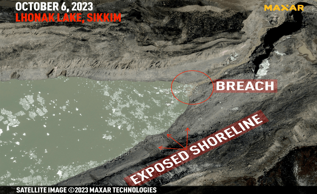
POST SCRIPT: 1. Oct 7 2023: New high-resolution satellite imagery from Friday (Oct 6 2023) shows the exact site of the breach at the high-altitude South Lhonak Lake in Sikkim. The images show exposed parts of the lake’s banks, indicating that the water level continues to drop significantly after draining out of the breach, and causing massive floods along the Teesta River basin downstream.

There is also evidence of a landslide, which may been a contributing factor in the lake bursting its banks.
“The glacier has significant snow presently, and this snowpack might have exerted tremendous pressure on the snout of the lake, which gave rise to the breach,” said Arup R Dasgupta, Managing Editor of Geospatial World (formerly GIS Development) magazine, and a veteran ISRO imagery expert.
The South Lhonak Lake was also fed by glacial run-off from the retreating North Lhonak glacier and the main Lhonak glacier. This increased the lake’s surface area by 500 metres and average depth by 50 metres, Dr SN Remya, the lead scientist of the 2013 paper, said.
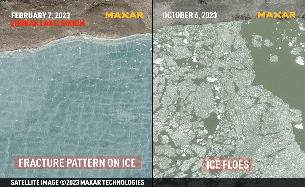
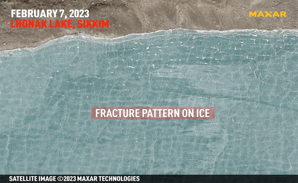
“The ice cover on the lake in the first images shows a regular fracture pattern, which indicates that the ice sheet was under pressure, possibly from the glacier. This pressure was perhaps increased due to fresh snow on the glacier as seen in the second image. This might have led to the breach,” said Mr Dasgupta.

The image from October 6 also shows clear evidence of a landslide on one of the banks of South Lhonak Lake. It is unclear if the landside resulted in the displacement of water and was a contributory factor, which resulted in the lake breaching its banks.
“In Sikkim, lake-terminating glaciers have shown accelerated growth… South Lhonak glacier is no different. It is one of the fastest-retreating glaciers and the associated proglacial South Lhonak Lake has become the largest and fastest-growing in the state… this has raised concerns about hazard potentials as downstream (areas) are heavily populated…” a study published in the journal Geomorphology highlighted in 2021.
https://www.ndtv.com/india-news/was-landslide-on-sikkim-lakes-bank-a-cause-of-deadly-floods-what-satellite-images-show-4459544
2. Oct 9 2023 Experts also say the dam was not designed to withstand a GLOF-like event – evidenced by the fact that it was reportedly swept away within 10 minutes of the flood hitting. “The Teesta III project is a rock filled concrete dam, which is structurally more vulnerable to flooding compared to a concrete dam,” said Himanshu Thakkar, convener of the South Asia Network on Dams, Rivers and People (SANDRP). “The Teesta V dam, which is further downstream, was able to survive the deluge partly because it’s a concrete dam and sturdier.”
– “The CEA found that the company planned to reduce the dam’s spillway capacity from 7000 cumecs to 3000 cumecs. A spillway capacity of 7000 cumecs is itself a conservative figure, based on a probable maximum flood due to rainfall and not accounting for a GLOF event, even though the risk of one occurring was well known,” said Neeraj Vagholikar, member of environmental NGO Kalpavriksh who brought the CEA’s observations to the notice of the Expert Appraisal Committee on river valley and hydroelectric projects of the Environment Ministry. “The government accepted some of the design changes, but rejected the proposal to reduce the spillway capacity further.”
– Both Thakkar and Vagholikar say that the spillway capacity was too insufficient to withstand the force of the October 4 flood. “But had an EWS been in place, dam authorities would have had sufficient time to drain the water from the reservoir, which would have reduced impacts downstream,” said Thakkar. In a recent interview with the publication, Hindustan Times, Teesta Urja Limited’s CEO said the spillway gates could not be opened in time. An investigation is on to determine why the spillway gates could not be opened in time.
3. Oct 11 2023: Reuter reports why the EWS to be installed at the South Lhonak Lake was delayed by a year: NDMA member Krishna S. Vatsa said there was a delay as it was a complex expedition for several reasons, including the fact that the lake, high in the mountains on India’s border with China, is accessible only from July to September. “It was a large inter-agency expedition, which could not be organised last year and had to be done this year, because you have to carry a lot of equipment … and there is a limited window to go to the site,” Vatsa told Reuters. “It’s a sensitive border area so we had to get all clearances,” he said. “…We also had limited time to get there, and we had to get all agencies to agree on one particular date for this expedition.” The work hence could begun only in Sept 2023, but could not be completed before the disaster struck.
– More than 200 such lakes now pose a very high hazard to Himalayan communities in India, Pakistan, China, Nepal and Bhutan, according to 2022 research.
https://www.reuters.com/world/india/early-warning-system-indias-flooded-glacial-lake-was-delayed-by-year-2023-10-11/
4. Oct 12 2023: Dave Petley Blog.
1. Animation of precursory deformation of the moraine to the north of South Lhonak lake, leading upto Oct 6, 2023 from 2016, put together by Bretwood Higman. The area of interest is in the northwest of the image, close to the Planet logo. The extension of active deformation is apparent as can be seen from the image dated Sept 26 2023 below.

2. Dan Shugar has tweeted showing Fresh landslide activity at South Lhonak Lake, Sikkim post Oct 3 2023 disaster. This small slump caused some flooding & it shows that newly exposed sediments are unstable and may continue to fail over the coming weeks until a new slope equilibrium is reached.
https://twitter.com/WaterSHEDLab/status/1712067159856406831
3. Dam Shugar in further thread provides pre and post disaster images showing:
– A tweet from Irfan Rashid showing the satellite images at Chungthang dam before the disaster (Sept 29 2023)
And After the disaster (Oct 9 2023).

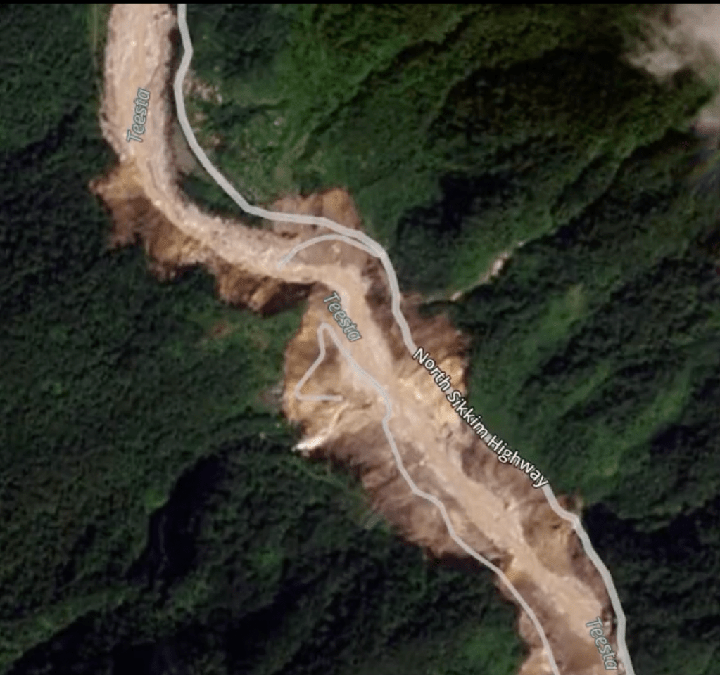
– The incredible erosion by the GLOF downstream of Chungthang Dam, w/ widened valleys, destroyed bridges, etc. At the Dikchu Dam hydropower project, the reservoir is now mostly drained. It appears (from news stories) that the dam suffered some damage but wasn’t destroyed.
– Landslides immediately upstream from Chungthang Dam, which appear to have been caused by undercutting of the banks. Some of these are no doubt existing features that have just had the vegetation stripped, but others appear like new features. Before the disaster, on Sept 6 2023
After the Disaster on Oct 9 2023:

– Upstream, at the confluence of Zemu Chu and Teesta, this is just downstream of the GLOF site. In some areas that appear to be a bit flatter and where the valley widens out a bit, massive deposition is seen, such as at the confluence of Zemu Chu (where the GLOF traveled) and Teesta River.
Before the Disaster (Sept 6 2023)
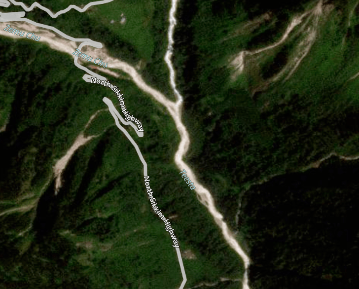
After the Disaster (Oct 9 2023):

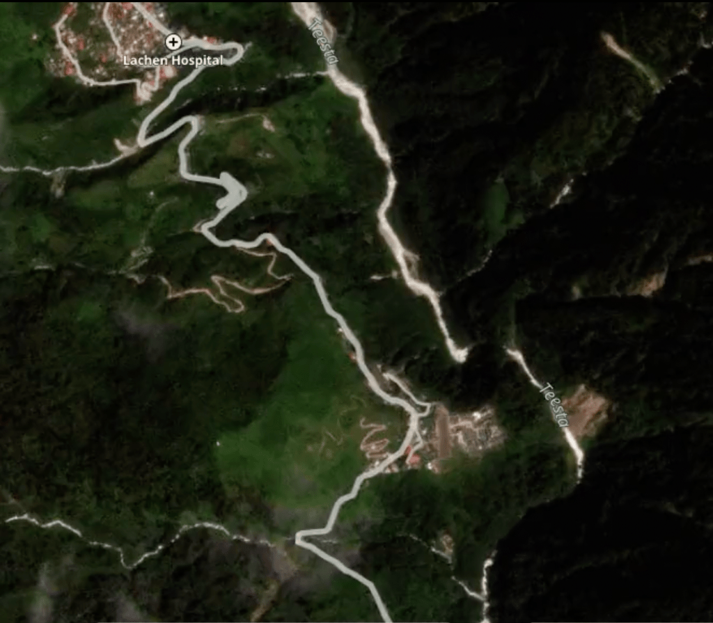
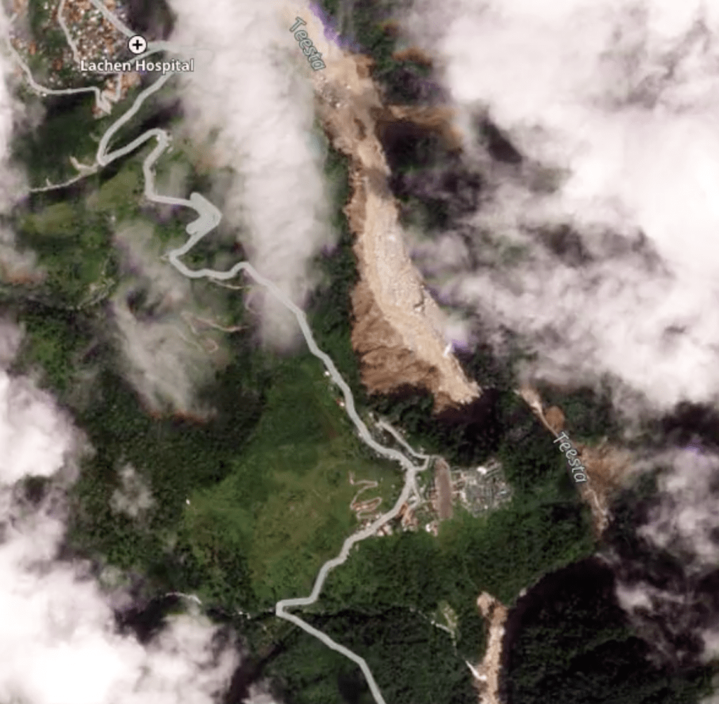
– Downstream from the above site, just downstream of Lachen, the Teesta River takes a very abrupt couple of turns, and it appears that the flow eroded a very large amount of hillside material here, possibly as the flow smashed into the opposing wall and then backed up as it slowed to go around the bend.
Before the disaster (Sept 6 2023):
After the Disaster (Oct 9 2023):
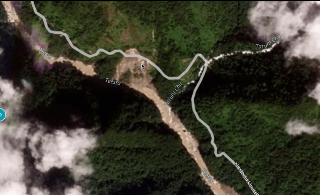
– Further downstream, the GLOF undercut some of the valley walls enough to also trigger some landslides, like this one at the confluence of Teesta and Tarum Chu.
Before the Disaster (Sept 6 2023):

After the Disaster (Oct 9 2023):
– Downstream, where the valleys look to be a bit narrower without a floodplain, the GLOF created a new one by scouring out the valley walls, leaving a trail of destruction.
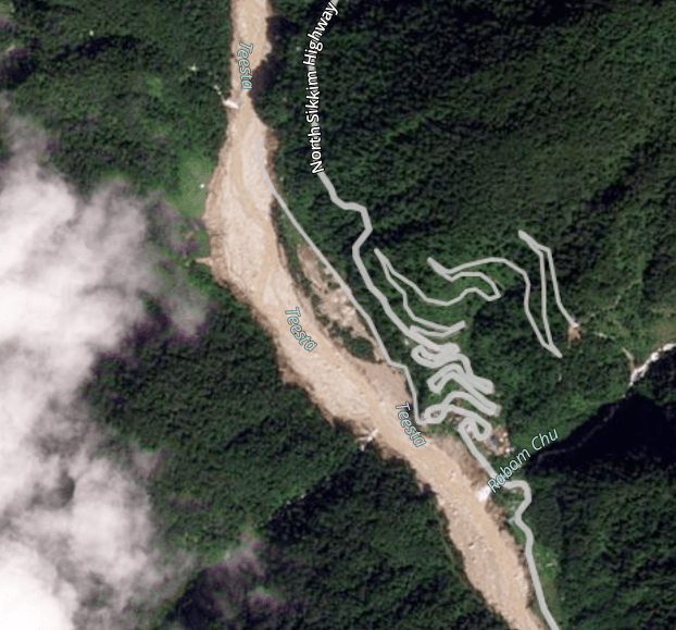
– More landslides downstream, which appear to have been caused by undercutting of the banks. Some of these are no doubt existing features that have just had the vegetation stripped, but others appear like new features.
– Before the disaster (Sept 6 2023)

After the Disaster (Oct 9 2023):
Active deformation around South Lhonak lake in Sikkim, India
5. Oct 13 2023: “In addition to new landslide at South Lhonak lake, I think there is substantially more to come down. The glacier retreated ~170-250m between March 2023 and October, which likely played a destabilizing role on the moraine (and probably exacerbated by being very wet),” tweeted Dan Shugar, geomorphologist, Associate Professor, University of Calgary on October 11. “To my eye, there appears to be lots of sediment extending ~500m up the glacier which is at the same angle as the failed material, and with a similar slip face at the top. If the glacier retreats another few hundred meters in the next year or two, this material may come down,” he added, posting satellite images of the lake.
– HT reported on October 8 that glaciologists warned earlier this year that there could be a GLOF at the Gephang Gath lake in Himachal Pradesh. There are 337 potential glacial lake sites in HP and Uttarakhand according to IISc. Said Anil Kulkarni of IISc: “The ‘red’ zones downstream need a special strategy like not allowing constructions, large projects etc. Locating large constructions such as dams is very risky here.”
https://www.hindustantimes.com/india-news/sikkims-lhonak-lake-still-at-risk-of-glof-floods-experts-101697134935768.html
6. Oct 14 2023: Dhiren G. Shrestha, principal director in the Sikkim’s Science & Technology Department said that a team of scientists from the state government’s Science & Technology Department had gone on an expedition to South Lhonak lake on 13-14 September 2023 to measure the volume of the water. The team sent a remote-controlled boat to do a bathymetry survey — conducted to measure depth and map underwater features — and found that the water near the snout (mouth of the glacier) of South Lhonak lake was approximately 120 metres deep.
– Scientists from the Sikkim government’s Science & Technology Department, who assessed satellite images from Sentinel-2, a European high-resolution imaging mission, said that the lake’s area dropped only slightly from 167 hectares on September 26 to 144 hectares on October 6. Shrestha said the lake is largely intact.
– They (authors of the 2021 paper led by Ashim Sattar) noted that the “enormous volume of water in a highly dynamic high-mountain environment makes this lake a priority for GLOF risk management”. They also found that “GLOF susceptibility will increase due to the expansion of the lake towards steep slopes, which are considered potential starting zones of avalanches”.

– In a report tabled in March this year, the parliamentary standing committee on water resources pushed for an early warning mechanism to monitor GLOF hazards. It also stressed the need for a multi-hazard alert and warning system for the Indian Himalayan region, noting that most such existing systems only deal with individual disasters. For example, the India Meteorological Department has a system for issuing alerts and warnings for heavy rainfall and cloudbursts, but it does not have any warning systems for other disasters such as GLOFs, avalanches, or landslides. “These disasters are either dealt with by other agencies or there exist no warning systems for them. To deal with these disasters in an integrated manner, a Multi-Hazard Warning System may be put in place through a real-time coordinated mechanism wherein one agency may be entrusted with the responsibility of continuously monitoring and issuing warnings and alerts to authorities, stakeholders and public,” the report said.
https://theprint.in/india/whats-a-moraine-how-its-fall-caused-sikkims-south-lhonak-lake-flood-and-why-threat-remains/1798392/
7. Oct 18 2023: Interesting statements from Union Power Minister: Almost two weeks after the Sikkim disaster of Oct 3-4, the Power Minister still does not know if the Teesta 3 project, washed away by the GLOF, had an early warning system or not. They are still “looking into this”. Similarly, while claiming early warning systems have been installed at some hydropower projects, it is not clear which are these, there is no list forthcoming. This report also mentions that DRDO has been roped in, in Dec 2022 to put early warning systems, but not clear what is the progress.
https://www.moneycontrol.com/news/business/sikkim-flash-flood-power-ministry-investigating-early-warning-system-at-teesta-urja-hydropower-project-rk-singh-11557411.html
8. Oct 20 2023: The Cabinet held on 17th October 2023 took a decisive step in response to the Teesta Stage-III Dam breach, a catastrophic event triggered by a sudden cloud burst and flash floods on the 4th of October, 2023, at Chungthang in the Mangan District. To address the gravity of the situation and ensure accountability, the Cabinet has directed the concerned department to form a High-Level Committee comprising Technical Experts, Financial Experts, and other relevant Subject Experts to:-
i. Examine the allotment process of Teesta Stage III, 1200 MW Project keeping in view the credibility, genuineness and technical know-how, financial solvency, etc of the Consortium.
ii. Examine the change in DPR before the allotment of the Project vis-a-vis technical and financial aspects.
iii. Purchase of Share by Government of Sikkim/ SPICL and how the valuation of Share was ascertained.
iv. Award of Contract and Subcontract by Sikkim Urja Limited (erstwhile Teesta Urja Limited- TUL).
v. Sell of equity by Athena Projects Pvt. Ltd. to Asian Genco Pvt. Ltd. and Others.
vi. All/any aspects of the Project award, execution, etc.
vii. Any other related issues as deemed fit and necessary by the Committee. The Cabinet also directed Sikkim Vigilance Police to conduct a comprehensive inquiry to find out whether there is any criminal angle in the whole process of construction of the Project and submit a report for registration of the case and transfer to CBI.
https://twitter.com/PSTamangGolay/status/1715017243116101790
9. Oct 22 2023: Photo blog on impact of GLOF on area close to Teesta river in W Bengal upto TLDP III:
https://savethehills.blogspot.com/2023/10/photographic-record-of-glof-impact-on.html
10. Oct 22 2023: ~30 km downstream of the South Lhonak lake, a GLOF-triggered landslide blocked the river channel, where a new landslide-damaged lake is formed. The lake has drained partially through a channel beneath the landslide debris but still exists.
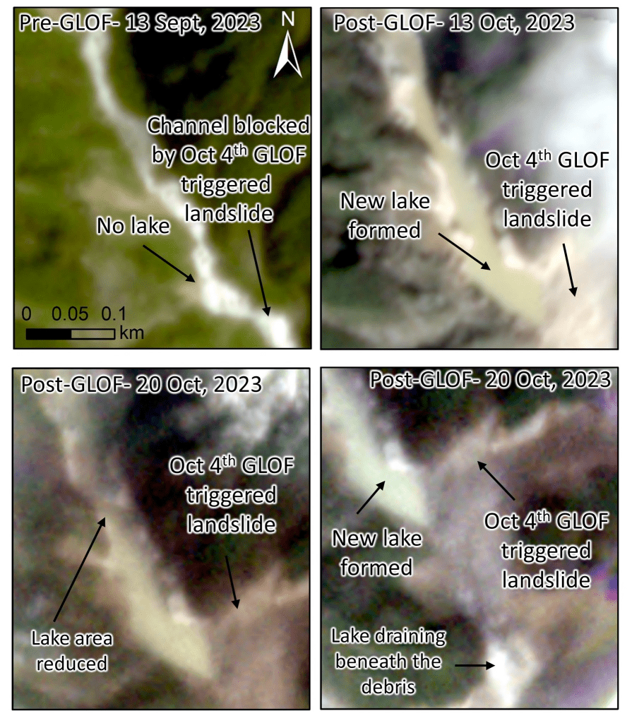
https://twitter.com/GlacierHazards/status/1715810944247599489
11. Oct 30 2023: According to this report, Teesta 3 project is likely to get Rs 500 cr from insurance for the damages it suffered on Oct 3-4, as the insurance cover in case of GLOF is limited to that figure.

12. Nov 7 2023: Very good report by Kavita Upadhyay:
– Dan Shugar, a geomorphologist from the University of Calgary in Canada, who is currently conducting research on the GLOF, noted that before the flood, the lake’s area was 1.62 sq. km, and after water being drained out in the GLOF, the area dropped to 1.46 sq. km. Adding to the existing hazard, weeks after the disaster, there have been continuous landslides along the slope that first failed on October 3, Dr. Shugar added.
– When the flood gushed through the valley, it triggered a landslide about 30 km downstream of the South Lhonak lake, which blocked the river, forming a landslide-dammed lake. After reviewing satellite images, Dr. Ashim Sattar, a mountain hazard specialist who is currently studying the GLOF and has authored research articles predicting different GLOF scenarios for the South Lhonak lake surmised that the lake had not drained even by November 1. Considering the risk of sudden release of water downstream, it requires monitoring.
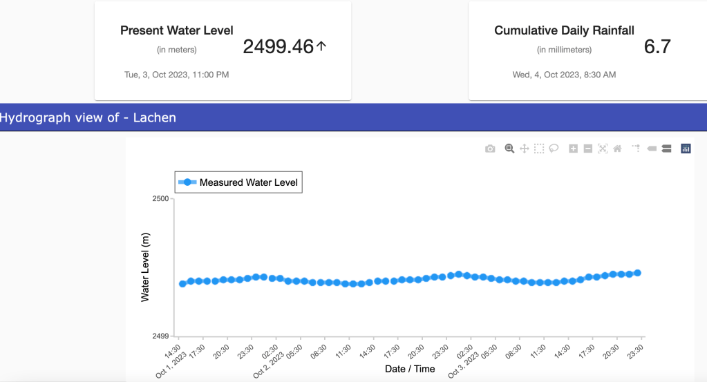
– The Sikkim government has been claiming that the GLOF was triggered by a cloudburst. In fact, Sikkim State Disaster Management Authority’s daily reports on deaths and damages continue to call the flood “cloudburst induced”. The National Disaster Management Authority’s October 4 press release also called the event a “likely combination of excess rainfall and a GLOF”. However, according to G.N. Raha, who heads the Meteorological Centre in Gangtok, the possibility of either a cloudburst or extreme rainfall triggering the GLOF is very low. The 10 weather stations across North Sikkim recorded light-to-moderate rainfall for the period of the GLOF, Dr. Raha said. On the morning of October 4, the station at Lachen, almost 46 km from the South Lhonak lake, recorded only 6.7 mm rainfall for 24 hours, he said. However, scientists continue to analyse meteorological data for accurate information regarding the role of rainfall in the GLOF.
– Maximillian Van Wyk de Vries, an assistant professor of physical geography at the University of Nottingham, U.K., said that at the South Lhonak lake, a large section of the lateral moraine was “moving for many years preceding the collapse, at a rate of several metres per year”.
– On October 13, the Indian Space Research Organisation’s (ISRO) National Remote Sensing Centre published satellite images showing a large deposit of sediments and several landslides along the path of the flood, especially in and around the Chungthang dam. The loose sediment may pose a threat to downstream areas in future, said Kalachand Sain, Director of the Dehradun-based Wadia Institute of Himalayan Geology. In view of the many hydropower-related dams in the Teesta Basin, the large amount of loose sediment that can easily be eroded by heavy water flow may imply a shorter lifespan for dams and lower efficiency for hydropower projects, scientists said.

– In 1990, the South Lhonak glacier was 6.4 km long. A research article published in 2021 found that, by 2019, it had reduced by about 1.3 km and that its area had declined by about 0.96 sq. km. In 1976, the South Lhonak lake area was a mere 0.20 sq. km, according to a research article published in 2018. As the glacier shrank, the lake grew larger. By 2019, the lake was covering 1.35 sq. km, per the 2021 article. Anil V. Kulkarni, Distinguished Scientist at the Bengaluru-based Indian Institute of Science’s Divecha Centre for Climate Change, said, “The lake’s rapid expansion might have weakened the permafrost that was holding the moraines, which would have been one of the important reasons behind slope failure on October 3.”
https://www.thehindu.com/sci-tech/energy-and-environment/south-lhonak-lake-flood-teesta-dam-climate/article67503729.ece
References:
[i] https://www.ndtv.com/india-news/sikkim-flood-sikkim-flash-flood-teesta-river-dam-parts-of-teesta-river-dam-washed-away-after-cloudburst-in-sikkim-4448215
[ii] https://en.m.wikipedia.org/wiki/South_Lhonak_Lake#
[iii] https://www.eastmojo.com/sikkim/2023/10/04/south-lhonark-lake-bursts-sikkim-on-high-alert/
[iv] https://www.telegraphindia.com/india/23-army-personnel-missing-in-sikkim-flash-flood/cid/1970913
[v] https://www.ndtv.com/india-news/sikkim-flash-flood-sikkim-flood-teesta-river-flash-flood-alert-in-sikkim-after-teesta-river-water-levels-rise-4447633
[vi] https://www.ndtv.com/india-news/sikkim-floods-23-soldiers-missing-after-cloudburst-triggers-flash-flood-in-sikkim-4447716
[vii] https://www.facebook.com/100083201895550/posts/pfbid02fivBf4s8QoMzu5T8eDHhjDA2aB2L1VzUsQYn8NQPCfbwzs2aQk1U7fPwvKWDY4Thl/?mibextid=cr9u03
[viii] https://cwc.gov.in/sites/default/files/nrld-2019.pdf
[ix] https://cea.nic.in/wp-content/uploads/hp___i/2022/06/COMPILATION_OF_SALIENT_FEATURES_3-1.xlsx
[x] https://www.nbmcw.com/article-report/case-studies-site-reports/teesta-iii-hydro-power-project-mix-design-and-application-of-hpc.html
[xi] https://powerline.net.in/2017/04/02/teesta-urja-limited/
[xii] https://ijtre.com/images/scripts/2014020308.pdf
[xiii] https://sandrp.in/2021/02/20/tapovan-vishnugad-hpp-delays-damages-and-destructions/
