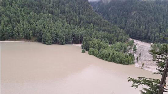
(Feature Image: Formation of artificial lake in Bhagirathi river at Harshil, Uttarkashi)
After 11 days since the Dharali disaster unfolded in Bhagirathi valley Uttarakhand on August 5, 2025, an artificial lake formed on Bhagirathi river has been removed to some extent by the joint team of concerned departments on Aug 16, 2025 noon. The lake was formed after the Tel gaad partially blocked the Bhagirathi river at Harshil about 2.5 km downstream of Dharali.
On the day of disaster, apart from the Kheer gaad (stream), the Tel gaad and Bhela gaad witnessed severe flash flood spell and carried debris and muck in huge volume. All the three streams originate from Srikantha mountain range and join Bhagirathi river in succession from left bank.
Though, the debris in Kheer gaad has pushed the Bhagirathi towards northern side, it was the deluge in Tel gaad that had partially blocked the river course opposite Harshil town, in addition to the debris contributed by Kheer gaad and Tel gaad. This resulted in formation of an artificial lake in the river for 10 days amid efforts to breach it.
Artificial Lake The artificial lake reportedly 1200-1500 meter long was formed at the confluence of Tel gaad and Bhagarathi river. This happened about 30-45 minutes after the Dharali disaster when a 15 feet high deluge in Tel gaad dumped huge amount of debris, uprooted trees into Bhagirathi river partially blocking its flowing course.
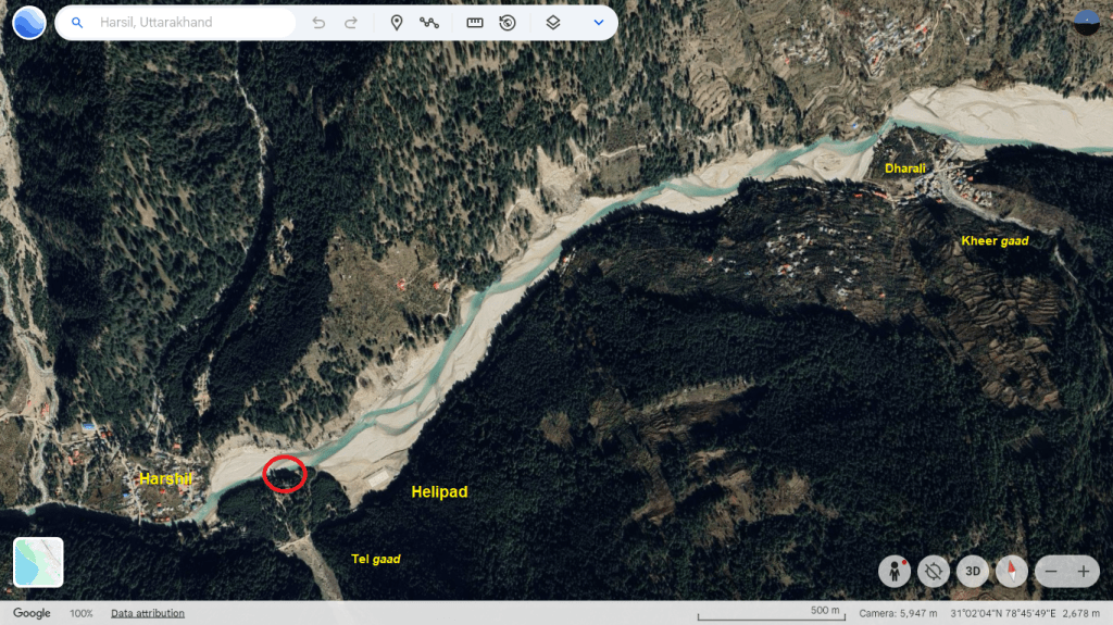
The flash flood in the Tel gaad also damaged the Army Camp at Harshil located on southern bank of the river. This is where about 9 army personnel went missing on the day of disaster. They were attached to 14 Rajputana Rifles.
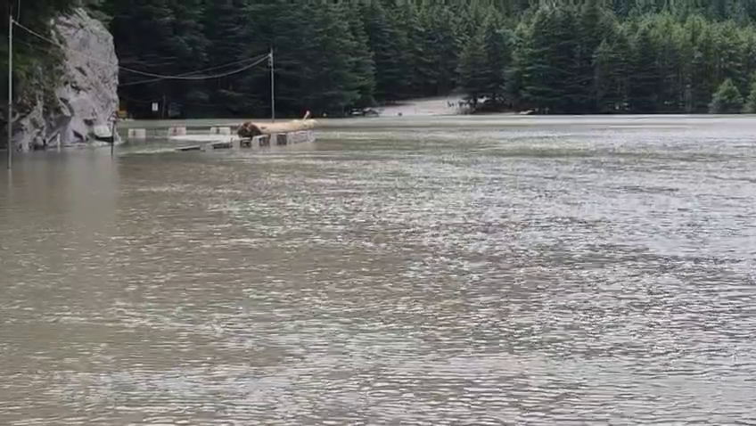
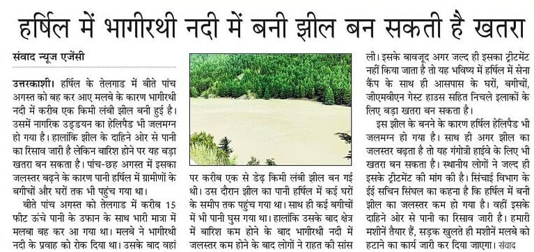
The rising water level in the lake in following days reached close to human habitation and flooded orchards at Harshil. A helipad built in Bhagirathi riverbed just upstream the confluence point was fully submerged. A part of Gangotri National Highway (NH) 34 was affected by the water impoundment in the lake. The constant erosion of right bank caused safety concerns for the river side buildings in Harshil town. The sudden breach of the lake also became a potential threat for human habitation at Harshil and in downstream areas.
Breach Efforts Initially, the focus was rescue, relief and road restoration work to access Dharali area. Reports on the possible threats from the artificial lake started coming after August 8. Subhash Chandra, Chief Engineer (CE), Irrigation Department who inspected the lake on Aug 7, dismissed it to be a threat to Harshil. As per him debris had blocked 90 per cent width of the Bhagirathi but water was continuously overflowing from unblocked portion of riverbed. He also said that there was no increase in lake’s size.
Fearing flood damage from the lake, the Harshil locals demanded its removal. Sachin Singhal, Executive Engineer (EE), Irrigation Department, Uttarkashi, stated that after halt in rain, the size of lake decreased and water was flowing out from right bank of the river. The Irrigation Department planned to use machines to increase the mouth of the lake once the road connectivity to reach Harshil was restored.
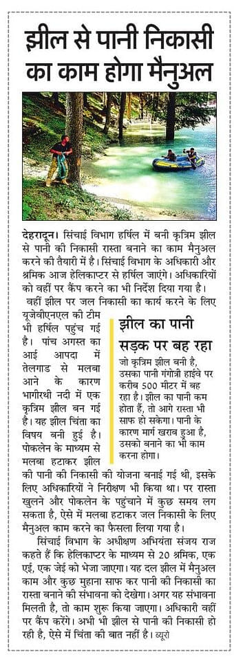
Next day (Aug 9), the Irrigation Department changed the plan and decided to breach the lake manually, after a site inspection found use of poclain machine unfeasible due to amount of silt, debris, tree logs blocking the river course and continual delay in road restoration work. On that day, Sanjay Raj, Superintending Engineer (SE) Irrigation Dept stated that a team of 20 workers would reach Harshil by helicopter to explore the possibility of breaching the lake manually. He added that given constant discharge, the lake was not a major cause of concern. A team from Uttarakhand Jal Vidyut Nigam Ltd (UJVNL) also reached Harshil for the same purpose.
A 3 minute long video published on Aug 09 showing extent of the artificial lake can be seen here.
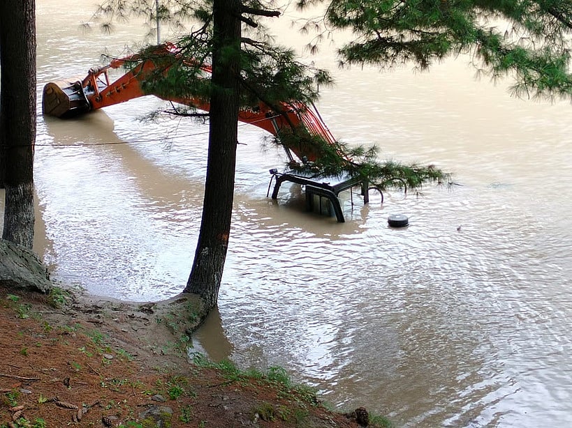
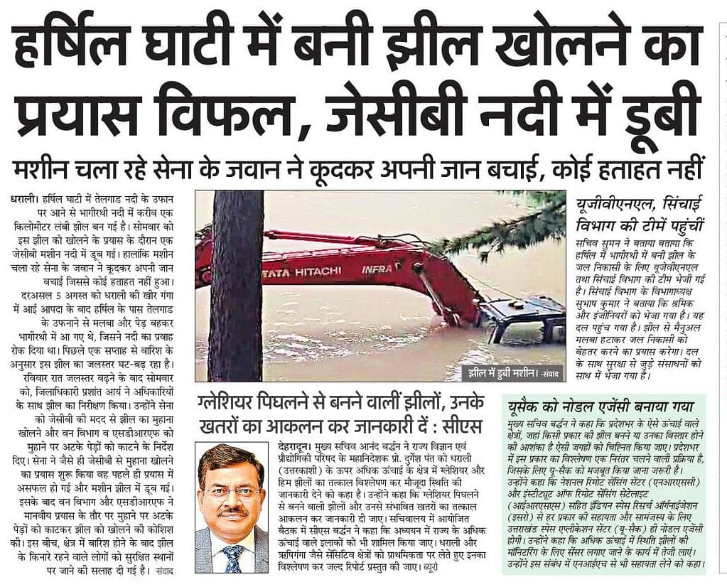
After visiting the lake site along with other officials, Prashant Arya, the District Magistrate (DM) Uttarkashi, directed the Army team to increase lake’s mouth with poclain machine on August 11. He also asked the Forest Department and State Disaster Response (SDRF) to cut off uprooted trees clogging the lake’s mouth. However, when the poclain machine tried to widen the lake’s mouth, it got submerged in the river in the first attempt and the Army man managed to save his life by jumping off it.
The ongoing rains over the week caused fluctuation in the water level of the lake and also affected the efforts to breach it. Given the situation, the administration advised the Harshil residents to move to safer places and in the wake of possible threats most of the residents left the town.
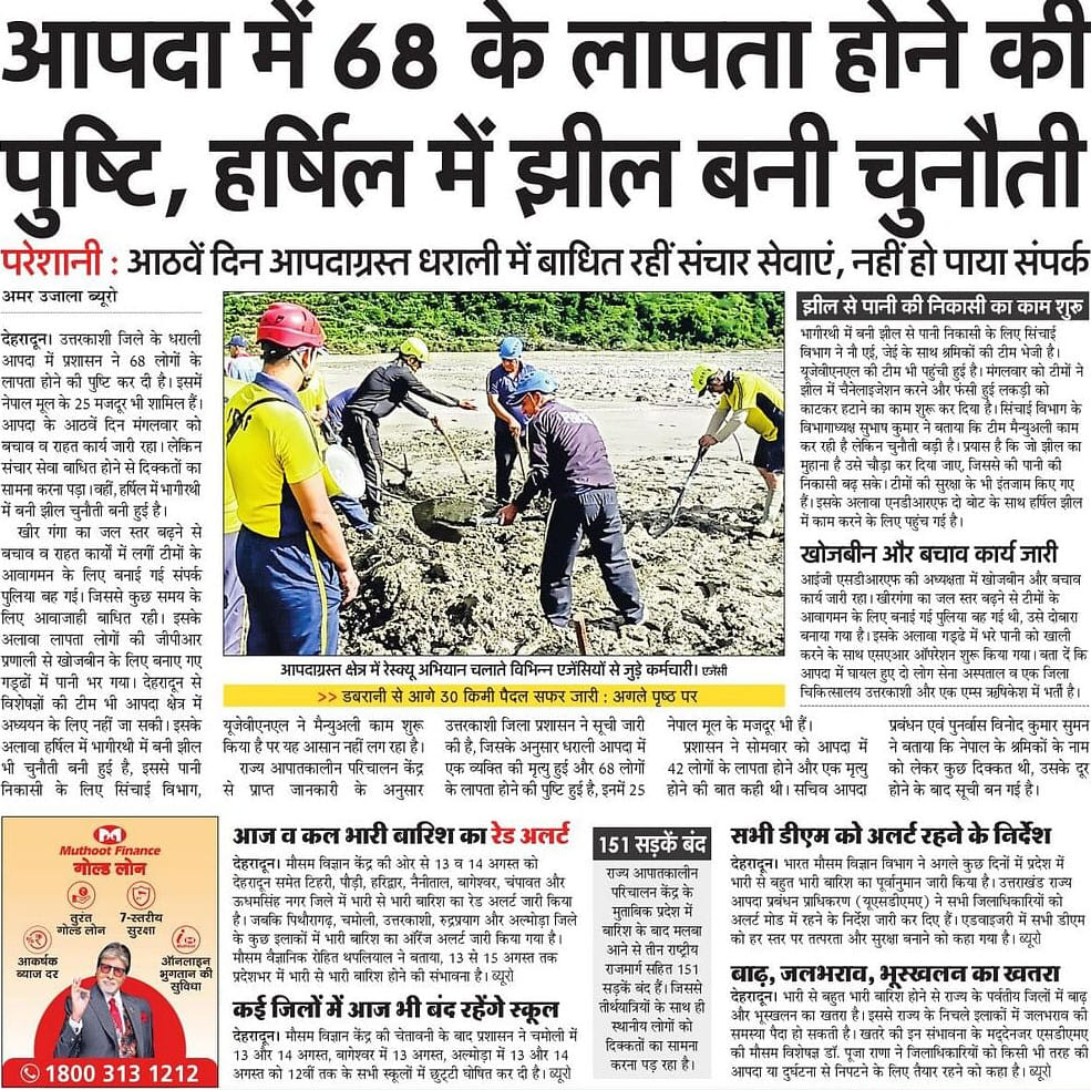
The Irrigation Department and UJVNL team started the work on increasing the mouth of the lake manually on August 12. The Irrigation Department found it a challenging task. The National Disaster Response Force (NDRF) deployed two outboard motors (OBM) boats to assist the breaching efforts.
A 10-member team of geologists also assessed the lake’s stability and advised on safe drainage. Based on the field visit, they prepared a plan for debris clearance and partial restoration of water flow. The plan involved creating small diversion channels of about 9-12 inches deep to gradually release the stagnant. It was emphasized that the lake outflow channels should be opened in three or four stages to avoid sudden flooding downstream. Work on this plan was started immediately by the SDRF and the Irrigation Department, Uttarkashi.
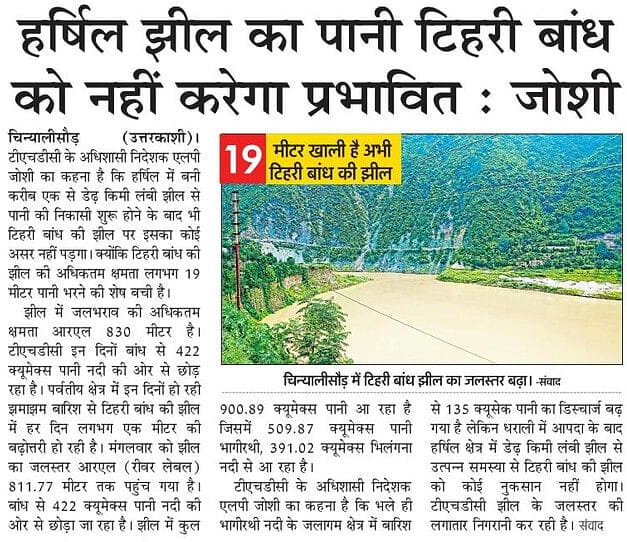
Meanwhile, L P Joshi, Executive Director, Tehri Hydro Development Corporation Limited (THDC) stated that though the rain in catchment had increased, Bhagirathi discharge to 135 cumecs, but it would not affect the Tehri dam as the reservoir level was still 19 meter below the maximum storage capacity. He also stated that the discharges from the 1.5 km long artificial lake would not cause any damage to the dam.
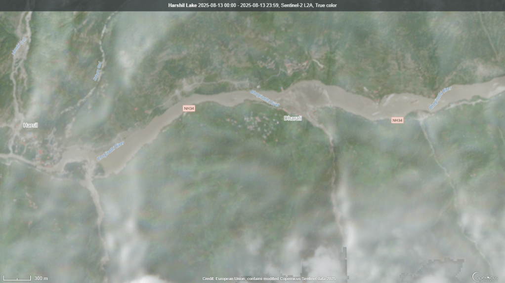
When SANDRP on August 14 contacted, Sanjay Raj, SE, Irrigation Department who was also coordinating with teams involved in the task, he stated that the lake was about 800 to 900 meter in length, 15-20 feet in depth with average width of 100 meters. The debris in Tel gaad had covered 75 percent width of Bhagirathi river course and there were continuous releases from the remaining portion. He also said that the lake had submerged about 200 m of Gangotri NH under 3-4 feet water.
On the question of delays in opening the lake’s mouth, the official stated that due to unavailability of hydraulics machines, they were dependent on manual methods to make openings in lake’s blockage in controlled manner to avoid any flash flood disaster in downstream areas. As per him the hydraulics machines could have done the job in two days but due to damage to the road from both Gangotri and Bhatwari sides, they were unable to get the machines. He was not sure how much time the manual efforts would take to create openings in the lake in the face of adverse weather conditions hampering the work.
On Aug 15, a team of geologists who had visited the area explained reasons behind lake formation. The team observed that a large amount of debris and water came and accumulated in the stream (Tel gaad) at its point of confluence with the Bhagirathi River and formed a large fan-shaped deposit (alluvial fan) of sediments. This fan with saturated sediments obstructed the original channel of the Bhagirathi River and formed a temporary lake on the right bank of the river. The high moisture content in fan area prevented use of heavy machinery.
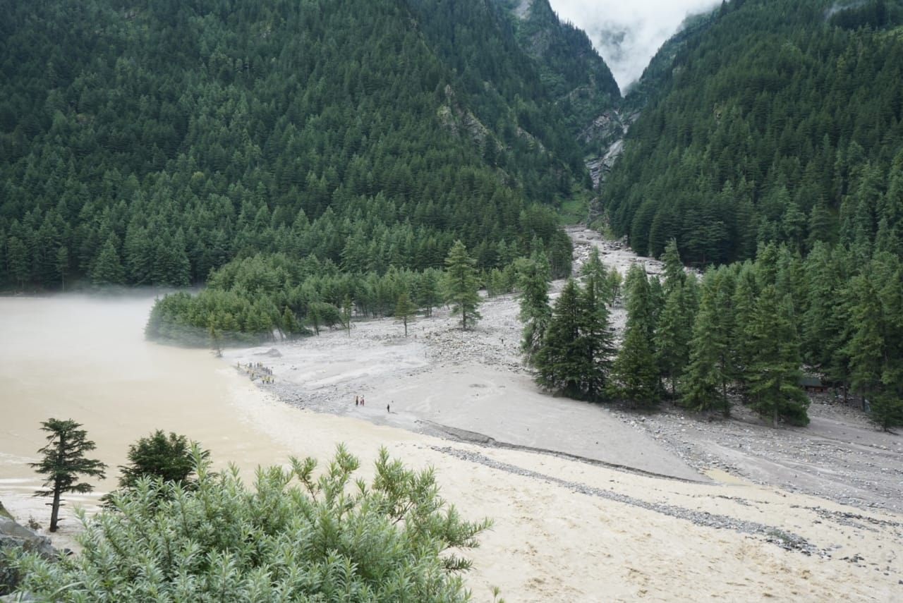
The event also significantly altered the topography of the Bhagirathi River, as the sand dune located on the right bank was eroded, while fresh sediment was deposited on the left side, exposing the northern part of the town. The continued bedrock erosion in this area had already caused partial structural damage to the camp, including the loss of a portion of the Garhwal Mandal Vikas Nigam Guest House.
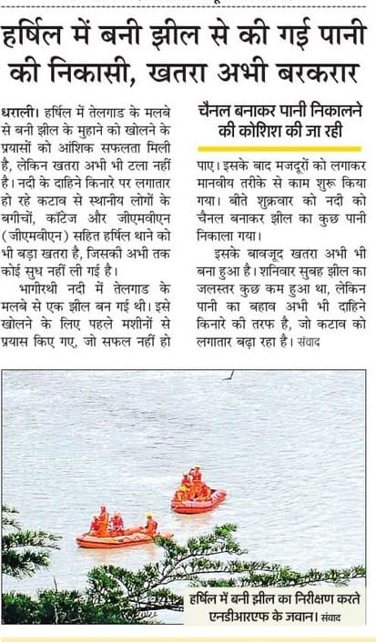
Efforts to puncture the lake manually continued between Aug 13-15. During this time, the team tried to create a separate channel just downstream the blockage part on left bank of the river and as per the latest updates the water in considerable amount has started flowing through the dredged channel on Aug 16 afternoon.
While, the partial removal of blockage has increased the discharges from the lake, however river water in large volume continues to flow along right bank causing erosion threats to homes, government buildings and orchards in Harshil.
Past Blockage: Interestingly, 47 years ago the course of Bhagirathi river witnessed a major blockade. The incident happened on Aug 5-6, 1978 near Dabrani located about 20 km downstream Harshil. The blockage was caused by a ‘cloudburst’ induced landslide in Kanodia gaad which joins Bhagirathi from right bank. This created about a 30 m high, 1 km long and 100 meter wide artificial lake in the river. The breach in the lake resulted in massive flood disaster in the downstream areas till Chinyalisour. In 1992, the blockade of Bhagirathi led to the closure of the Uttarkashi-Gangotri road for more than 25 days.
Question on CWC Flood Monitoring: So far, the team efforts seem to have been successful in partial removal of Bhagirathi blockage and avoid any imminent flash flood threats in downstream areas. However, the episode has once again raised question on the role and functions of Central Water Commission (CWC).
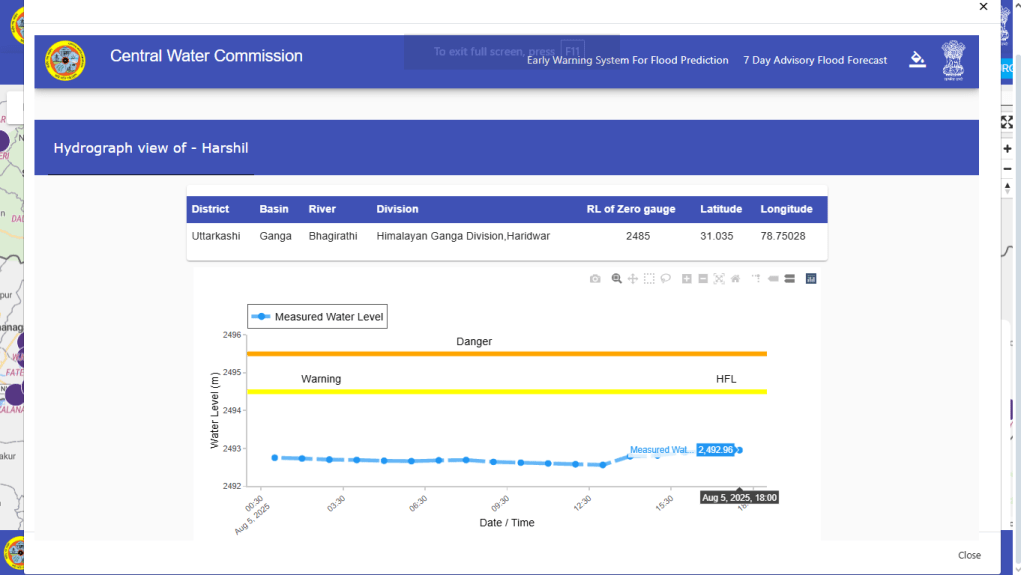
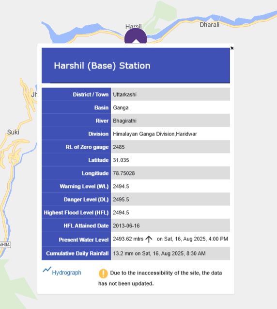
It has been observed that in recent past such flood disasters including Feb 2021 Chamoli, Oct 2023 Teesta have been affecting CWC’s flood monitoring work in Himalayan region. In Dharali disaster too, CWC’s Harshil station remained non-functional for about three days thus crippling the flood monitoring work when it was required most. The CWC did not share update on the issue till it was raised on X platform by SANDRP.
Responding to the issue first in the morning of August 6, the Sharad Chandra, the former CWC director of flood forecast division stated that the staffs were not allowed to visit the site. Replying to the question of communication gap by CWC and ways to address such situation, the former director stated that a robust telemetry system without human intervention can really be useful but designing this for such situation is a challenge and help of innovators is required.
Later the CWC Flood Forecast X handle mentioned same reason behind non-functioning of Harshil station. On the question of artificial lake, it informed that there was no major blockage of Bhagirathi river course.
It is worth mentioning that just on July 24, 2025, the Minister of State for Jal Shakti Raj Bhushan Choudhary in a written reply to a question in Lok Sabha submitted that CWC shares flood information on various social media platforms viz., Facebook, X, Flood Watch India Mobile App, etc. In reality, CWC has been doing it in very ritualistic manner and never updates general public about actual situation when its monitoring stations are affected and forecasting is most needed. Further in past 11 days, the agency has put no assessment or update on Bhagirathi river blockage in public domain.
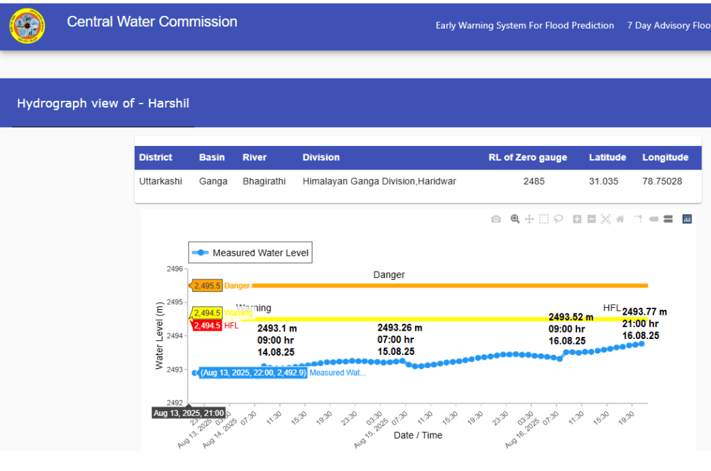
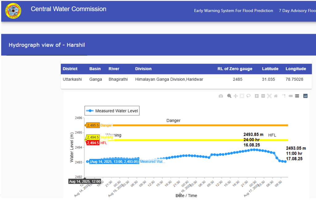
In response to SANDRP queries to at least share actual situation of Harshil station, CWC from Aug 8 onwards inserted a message at the bottom of the box carrying basic details about the Harshil station which reads, “Due to the inaccessibility of the site, the data has not been updated.” Although the hydrograph is active since Aug 10 and has latest updates on water level in the river, the message is still there. All this once again shows fundamental inadequacies of CWC’s flood monitoring and forecasting work.
SANDRP
Postscript: (10:00 pm, Aug. 22) Even after 16 days, about 100 meter stretch of Gangotri NH is still submerged under artificial lake’s water. The channelization work has brought down water level in the lake to some extent but the team has not got the expected success to widen the lake’s mouth. Formation of a silt bar in the river after decrease in the level has diverted water flows towards the NH. As the back of loader machine was stuck in the marshy area during first attempt, the army initially had refused to deploy the machine again. After request the machine was used again on Aug 19 but the marshy riverbed is making its operation diffucult and use of the machine for further channelization work has been stopped since Aug. 21 there.

Dharali disaster: Bhagirathi blockage partially breached, monitoring failures exposed https://www.counterview.net/2025/08/dharali-disaster-bhagirathi-blockage.html
LikeLike