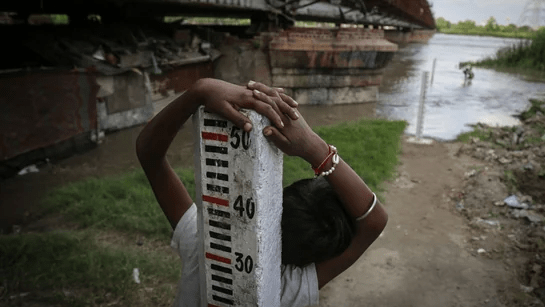
(Feature Image: Pillar with flood level marked on the bank of Yamuna river at Old Railway Bridge level forecast site in Delhi. Source:- Sanchit Khanna/HT Photos)
During monsoon season, Centre Water Commission’s (CWC) carries flood monitoring and forecast work through a network of 332 stations[i] covering 20 major river basins. The stations are comprised of Level Forecast (LF), Level Monitoring (LM) and Inflow Forecast (IF) sites. The LF sites have Warning Level (WL), Danger Level (DL), Highest Flood Level (HFL), date of HFL information while LM sites maintain HFL and HFL date records. At IF sites flood level for respective dams/ barrages with inflow, out flow figures are measured and forecast is issued accordingly.
However, there are plenty of concerns plaguing CWC’s flood forecast and monitoring work across country for years. In this 2022 SW monsoon season, the agency has exhibited one more problematic tendency which exhibits not only its careless approach vis-a-vis keeping accurate information of HFL breach events, but it also seems strange that it realises it has giving wrong HFL level and date information mostly only after crossing the HFL now.
To illustrate, the present case is of eight flood monitoring stations of which four are in Uttar Pradesh, one in Madhya Pradesh and three in Karnataka.
Uttar Pradesh The four sites in Uttar Pradesh are Pailani Dera on Ken River and Marka on Yamuna river in Banda district and Lamyari on Baghain river and Sardhua on Paisuni river in Chitrakoot district.
River Ken in Pailani Dera LM site was flowing in extreme floods after crossing the old HFL 102.28 m at 17:00 hour on 26.08.2022. The flood level had reached 102.82 m at 12:00 hour on 27.08.2022 before, suddenly the HFL was raised by 2.17 m making it 104.45 m by that evening. The CWC had not mentioned the HFL date when the river breached the HFL and wrongly listed the site in Shahjhanpur district in place of Banda. The mistakes were corrected later.
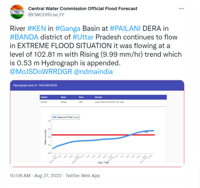
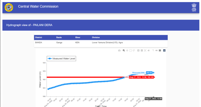
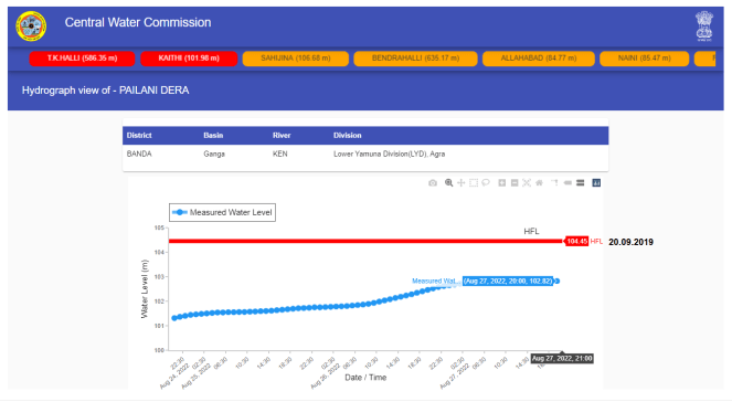
Hydrographs before and after CWC raised the HFL for Pailani Dera site on Ken river. Screen shot of CWC twitter post showing the river in Extreme Floods before the HFL raised abruptly.
Similarly, river Baghain at Lamyari LM site had crossed previous HFL 94.2 m at 03:00 hour on 27.08.2022. The river was in extreme flood situation till 12:00 hour on 27.08.2022 before the HFL was raised to 101.2 m an increase of 7 m by evening on the same day. CWC did not mention the HFL date when the river breached the HFL. Even the HFL date 23.09.2019 given later was changed to 21.09.2019.
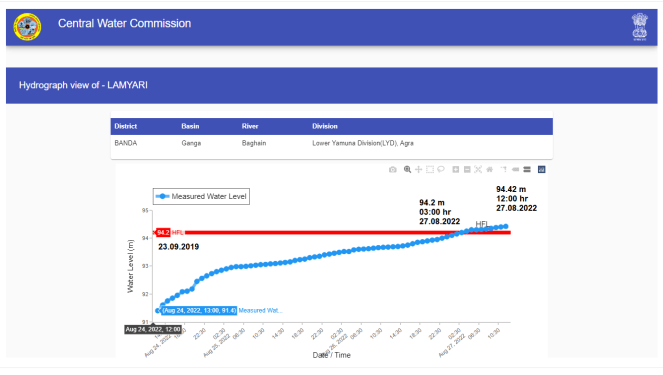
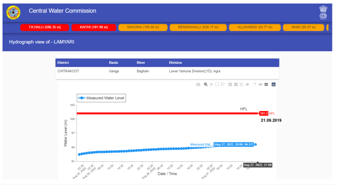
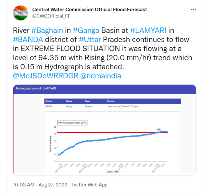
Hydrographs before and after CWC raised the HFL for Lamyari site on Baghain river. Screen shot of CWC twitter post showing the river in Extreme Floods before the HFL raised abruptly.
River Yamuna at Marka LM site breached the previous HFL 97.07 m (attained on 21.09.2019) at 21:00 hour on 24.08.2022. The flood level reached to 99.16 m at 13:00 hour on 27.08.2022 which was 2.09 m higher than the previous HFL. However, by evening the HFL was raised to 99.59 m which is 2.52 m higher than the previous HFL. Even the HFL date was changed to 20.09.2019 from 29.09.2019 given earlier.
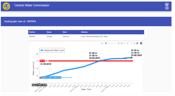
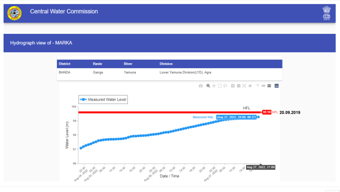
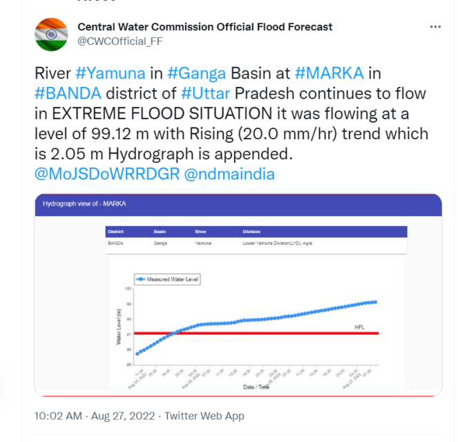
Hydrographs before and after CWC raised the HFL for Marka site on Yamuna river. Screen shot of CWC twitter post showing the river in Extreme Floods before the HFL raised abruptly.
Same happened with Sardhua LM site on Paisuni river which had crossed previous HFL 90.07 m (dated 21.09.2019) at 22:00 hour on 25.08.2022. The river was flowing in extreme flood situation and had reached the level 91.04 m at 13:00 hour on 27.08.2022 which was 0.97 m higher than the recorded HFL. But by evening, the CWC raised the HFL by 9 m making it 99.07m as new HFL.

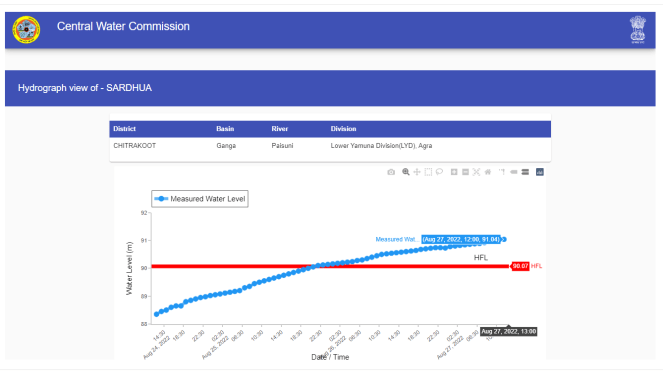
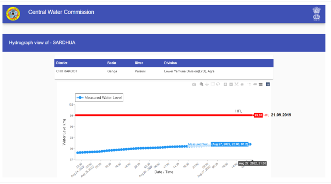
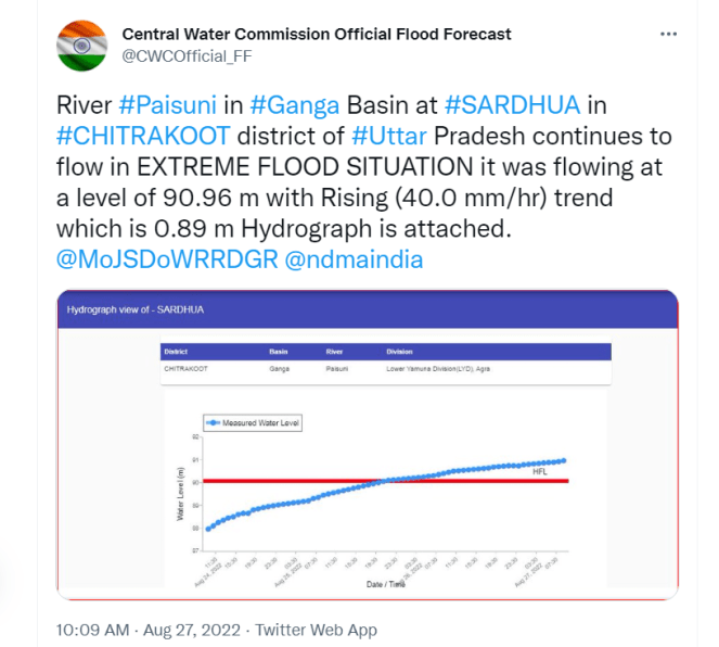
Hydrographs before and after CWC raised the HFL for Sardhua site on Paisuni river. Screen shot of CWC twitter post showing the river in Extreme Floods before the HFL raised abruptly.
When the issue was raised on twitter, Sharad Chandra, Director, CWC replied that the increase in HFL was due to wrong data entry[ii] by the division. Surprisingly, CWC is realizing the gross error only AFTER the HFL given for these sites were already breached.
Also the Sardhua site was wrongly listed[iii] in Shahjhanpur district instead of Chitrakoot. Likewise, the Kaithi LM site on Chandrawal river was included in Hamirpur district of Himachal Pradesh in place of Uttar Pradesh. The river had breached the old HFL 101.41 m on 26.08.2022 at this site. Initially, CWC had not provided old HFL date for the site. Both of the mistakes were corrected later.
Table detailing the sites and ad-hoc changes in HFL data
| Site | River/ District | Old HFL (m) | Date | Peak | Date | New HFL (m) | Date | Raise (m) |
| Pailani Dera | Ken/ Banda | 102.28 | 20.09.2019 | 102.82 | 27.08.22 | 104.45 | 20.09.2019 | 2.17 m |
| Lamyari | Baghain/ Chitrakoot | 94.2 | 23.09.2019 | 94.42 | 27.08.22 | 101.2 | 21.09.2019 | 7 m |
| Marka | Yamuna/ Banda | 97.07 | 21.09.2019 | 99.16 | 27.08.22 | 99.59 | 20.09.2019 | 2.52 m |
| Sardhua | Paisuni/ Chitrakoot | 90.07 | 21.09.2019 | 91.04 | 27.08.22 | 99.07 | 21.09.2019 | 9 m |
Madhya Pradesh CWC abruptly increased the HFL for Silgi at Kotrai LM site on Narmada river in Dindori district, Madhya Pradesh from 513.65 m with HFL attained date 08.08.2019 to 514.5 m with HFL attained date 22.08.2022 when the river was in extreme flood situation after breaching the 2019 HFL.
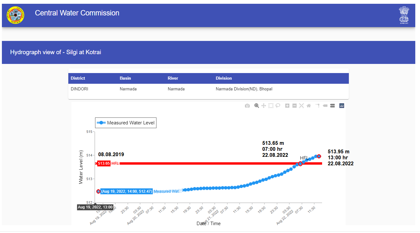
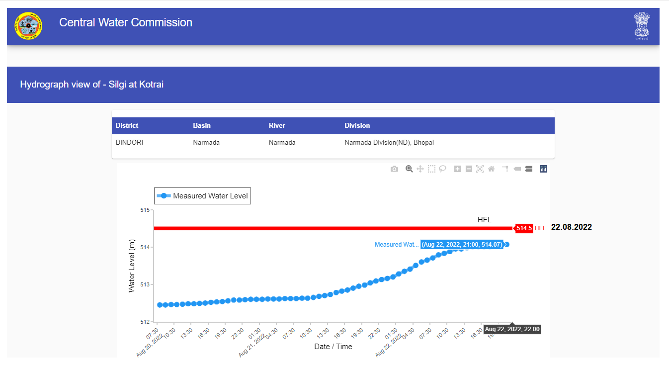
Hydrographs before and after CWC raised the HFL for Silgi at Kotrai site on Narmada river.
Karnataka Similar issues have been observed for three sites in Karnataka, namely T.K. Halli site on Shimsa river in Cauvery basin in Mandya district, T. Bekkupe site and Kokkedoddy site both on Arakavathy river in Cauvery basin but wrongly listed under Mandya district.
The T K Halli was a LM site with 585.95 m as HFL without any date as per SANDRP’s 2019 overview[iv] of CWC’s flood monitoring sites in South India.
The HFL was breached at the site on 02.082022 and CWC mentioned the old HFL as 585.925 m dated 03.10.1984. When we shared[v] HFL as per our 2019 record with CWC through twitter, there was no reply but CWC changed it to 585.95 m. CWC also upgraded the site from LM to LF site.
Slideshow of hydrographs showing HFL breach and changes in TK Halli site in August 2022.
The river at this site had attained 588.05 m as the new HFL on 04.08.2022. It again breached old HFL (585.95 m) at 13:00 hour on 27.08.2022 and reached upto 586.35 m by 19:00 hour. The flood level kept rising all through 28.08.2022 reaching 586.5 m at 23:00 hour. Same day CWC upgraded the HFL to 588.05 m attained on 04.08.2022.
This shows CWC did not maintain the correct HFL record attained on 03.10.1984 for the site. By 2019, this date was not registered by CWC on its flood forecast website. The site seems to be upgraded into LF site without any explanation.
CWC updated the HFL to 588.05 m, HFL attained on 04.08.2022 only after the site breached the 1984 HFL on 27.08.2022. Since its very old site, the new HFL (588.05 m dated 04.08.2022) should have been updated at the end of this monsoon season, as it the CWC practice. Upgrading the sites to LF also seems to be done during monsoon season which should be done after the monsoon season ends.
The T. Bekkupe site was a LM site in Bangalore Rural district with 606.95 m as HFL without any date given by CWC as per our 2019 record.
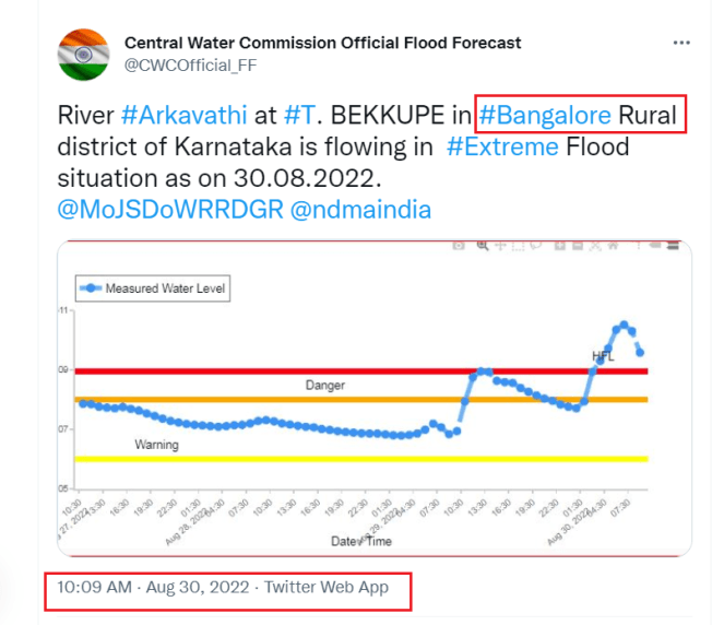
Arkavathi river at this site breached the HFL on 29.08.2022. Following this Shri S Laxminarayanan, a retired hydro-meteorologist from CWC mentioned[vi] that the site is in Ramanagara district while the hydrograph showed it in Mandya district.
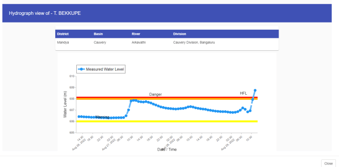
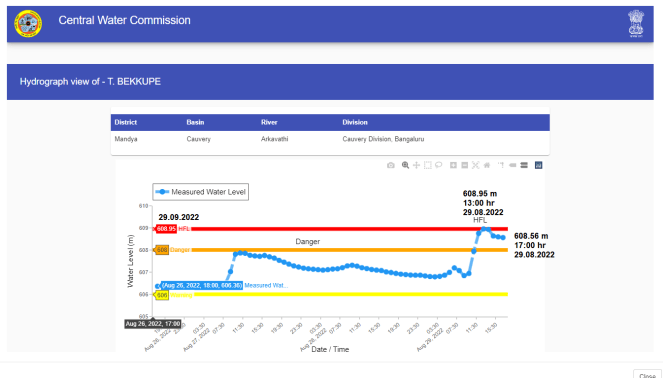
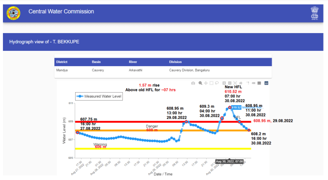
Slideshow of hydrographs showing HFL breach and changes in T. Bekkupe site in August 2022.
The CWC has also upgraded this LM site into LF adding 606 m as warning and 608 m as danger level which is about 1.05 m higher than the undated HFL 606.95. The HFL is also changed to possibly 608.10 m with date unavailable as CWC abruptly updated the HFL 608.95 m attained on 29.08.2022 without waiting for the flood level decline below the old HFL (possibly around 608.10 m).
The matter is raised with CWC[vii] on twitter seeking details of old HFL date (2019), new HFL date (possibly 608.10 m) and the exact district the site is located in. Interestingly, the official twitter handle of CWC mentions[viii] the site in Bangalore Rural district while hydrograph continued to show it in Mandya district till 30.08.2022. However, responding to our tweet CWC Director confirms[ix] that the site is in Ramnagar district. Same is now corrected on CWC website after this.
It is still unknown why and when the LM site is upgraded into LF and when the HFL (possibly 608.10 m) was attained. As per our 2019 HFL breach report[x] the site reached the level of 606.95 m on 03.10.2019 and has not breached or reached this HFL in 2020, 2021 year.
So on what basis CWC has maintained the previous HFL (which is breached on 29.08.2022) and why the agency abruptly updated the new HFL attained on 29.08.2022 though it’s also a very old site.
Similarly the Kokkedoddy was a LM site on Arkavathi river without any HFL, date listed under Bangalore Rural district in 2019. But, now the site is shown in Mandya district with 373.06 m as HFL dated 09.10.2017 and this HFL is breached by the river on 30.08.2022.
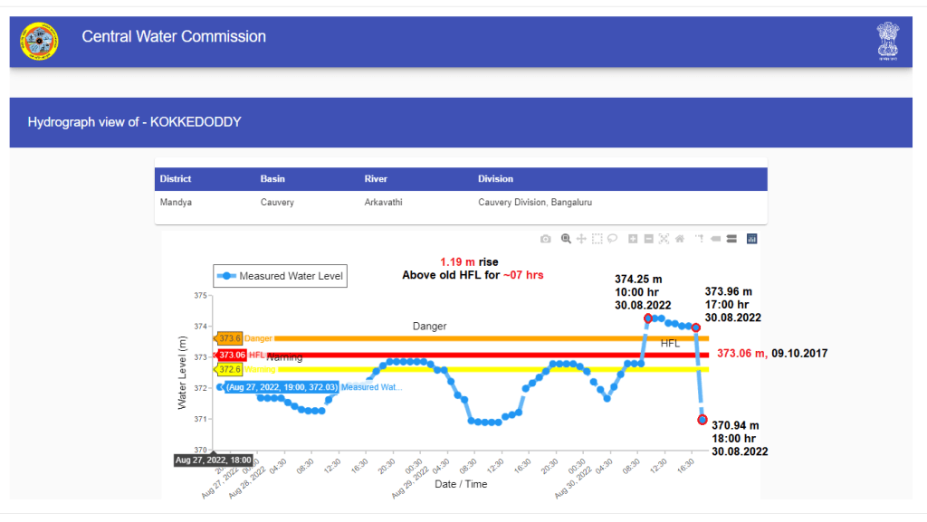
As per Sharad Chandra, the actual district[xi] for the site is Ramnagar and it was wrongly entered in Mandya district by the division. Sharing that there are many sites with warning and danger level available but not functioning as forecast sites, he also states that the Kokkedoddy is still a monitoring site. On why the 2017 HFL details were not updated till 2019, CWC-FF Director said[xii] he will look into the issue.
These are among few glaring examples revealing how carelessly the HFL, dates records are being maintained by CWC apart from listing the sites under wrong districts for years. Clearly, this is a new tendency afflicting CWC’s non transparent, unaccountable flood forecast and monitoring work. The agency, it seems, in ad-hoc and questionable manner increased the HFL for these sites only AFTER the rivers breached the mentioned HFL during extreme flood situation there.
Officially, the agency is supposed to maintain the HFL breach events and dates accurately and transparently which is essential and crucial part of its work. The HFL breach data must be put in public domain at the end of monsoon season. There should be an accountability when such gross errors happen.
Bhim Singh Rawat (bhim.sandrp@gmail.com)
The recent overviews by SANDRP has highlighted several such shortcomings and problematic issues in CWC’s flood monitoring stations in North and North East India.
References:
[i] https://pib.gov.in/PressReleaseIframePage.aspx?PRID=1848467
[ii] https://twitter.com/sharadcha1/status/1563761208897183744?s=20&t=JcL4imOcN80XzB6nUk1vfQ
[iii] https://twitter.com/sharadcha1/status/1563336971811819520?s=20&t=JcL4imOcN80XzB6nUk1vfQ
[iv] https://sandrp.in/2019/10/18/south-india-overview-of-cwc-flood-forecasting-sites-2019/
[v] https://twitter.com/Indian_Rivers/status/1554505350576885765?s=20&t=JcL4imOcN80XzB6nUk1vfQ
[vi] https://twitter.com/sln_1962/status/1564144522170626048?s=20&t=JcL4imOcN80XzB6nUk1vfQ
[vii] https://twitter.com/Indian_Rivers/status/1564249139554095104?s=20&t=JcL4imOcN80XzB6nUk1vfQ
[viii] https://twitter.com/CWCOfficial_FF/status/1564472845060943872?s=20&t=sjkMma6bgOVx4TgALk0yZA
[ix] https://twitter.com/sharadcha1/status/1564648895707090945?s=20&t=sjkMma6bgOVx4TgALk0yZA
[x] https://sandrp.in/2019/10/29/rivers-that-cross-highest-flood-level-during-sw-monsoon-2019/
[xi] https://twitter.com/sharadcha1/status/1564642177011318784?s=20&t=NcrvPVdLTJcsFe3DYO5PTA
[xii] https://twitter.com/sharadcha1/status/1564648567255355392?s=20&t=NcrvPVdLTJcsFe3DYO5PTA
