Feature image: CWC’s flow diagram map showing movement of flash flood in Alaknanda valley, Chamoli after landslide induced deluge on Feb. 7, 2021.
The landslide induced[i] flash flood disaster has left long-lasting trail of destruction along the Rishiganga-Dhauliganga-Alaknanda rivers. The flood sludge has filled up the riverbed after damaging infrastructures along the rivers. The rescue work still is underway.
The episode has reignited discussion on vulnerabilities of Uttarakhand, role of hydropower projects and climate change threats. Questions are being raised on destructive projects involving use of blasting, heavy machinery, tree felling challenging the resilience limits of fragile ecology of the region.
Debris have settled down. Experts have set out to explore possible causes. Concerns are mounting to draw the lessons. Amid this, one needs to look into the role and functioning of Central Water Commission (CWC) Flood Forecasting[ii] during the episode.
The agency has 78 CWC’s flood monitoring sites in the state comprising of 15 level forecasting, 60 level monitoring and 3 inflow forecasting. The issues with the sites and monitoring have already been highlighted in annual overview[iii] by SANDRP.
The Chamoli deluge has caught the CWC on the wrong foot again. By 11:00 am on February 7, 2021; social media was flooded with messages, images and videos of deluge devastating bridges, structures and hydro projects on Rishi Ganga, Dhauliganga and Alaknanda river.
To assess gravity of situation when CWC’s website and social media outlets were checked around 01:30 pm, there was no update available for general public. The agency and concerned were reached out around 02:00 pm via twitter. However it shared first information on the platform only around 06:00 pm in the evening. Its website also became functioning and the hydrographs of water level in the rivers at different sites were made available.
The information showed that the debris flowed had breached the highest flood level (HFL) of June 2013 at Joshimath site by massive 3.11 meter and there was no significant rise in water levels at downstream Rudraprayag site.
But the exercise was already late by seven crucial hours. By that time much of the destruction had taken place and the flood peak had already passed. The deluge had slowed down moving downstream. The reason for CWC’s Flood Forecasting being absent from the scene during those crucial hours could be it being an off season event in winter time when flow in the rivers is comparatively low. Secondly, the calamity had struck a limited glaciated area close to Trishul peaks. Hence the impact was restricted upto first about 100 km along Rishiganga, Dhauliganga and Alaknanda rivers.
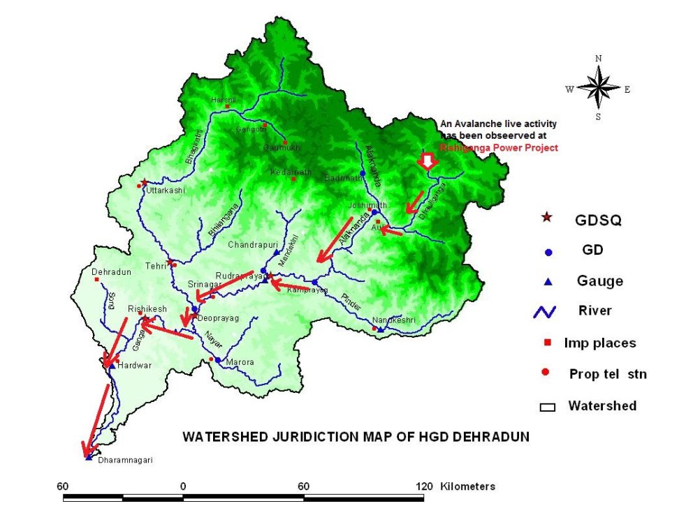
Flood monitoring sites in Alaknanda basin
The CWC has 16 flood monitoring sites in the Alaknanda basin comprising 4 level forecasting sites and 12 level monitoring sites. Of these 9 sites are along the path of deluge flow.
2021: List of Level Forecasting Sites in Alaknanda Basin
| SN | Site | River | District | WL, M | DL, M | HFL, M | HFL Date |
| 1 | Joshimath | Alaknanda | Chamoli | 1382 | 1383 | 1385.54 | 28-06-2013 |
| 2 | Nandkeshri | Pinder | Chamoli | 1267 | 1268 | 1267.4 | 17-06-2013 |
| 3 | Karnaprayag (Base) | Pinder | Chamoli | 772 | 773 | 774.05 | 17-06-2013 |
| 4 | Srinagar | Alaknanda | Pauri | 535.0 | 536.0 | 537.9 | 17-06-2013 |
Note: WL: Warning Level; DL: Danger Level; HFL: Highest Flood Level; M: Meters
2021: List of Level Monitoring Sites in Alaknanda Basin
| SN | Site | River | District | HFL, M | HFL Date |
| 1 | Badrinath | Alaknanada | Chamoli | 3112.7 | 01-08-2007 |
| 2 | Vishnuprayag | Mandakini | Chamoli | 1424.26 | 11-08-2019 |
| 3 | Pipalkoti | Alaknanda | Chamoli | 1051.78 | 19-08-2019 |
| 4 | Chhinka | Alaknanda | Chamoli | 1005.69 | 19-08-2019 |
| 5 | Nandprayag | Alaknanda | Chamoli | 853.24 | 18-08-2019 |
| 6 | Karan Prayag | Pinder | Chamoli | 758.3 | 18-08-2019 |
| 7 | Rudraprayag(M) | Mandakani | Rudraprayag | 634.0 | 17-06-2013 |
| 8 | Rudraprayag(A) | Alaknanda | Rudraprayag | 634.85 | 17-06-2013 |
| 9 | Rudraprayag (Conf) | Alaknanda | Rudraprayag | 633.0 | 17-06-2013 |
| 10 | Devprayag (Alak) | Alaknanda | Pouri | 466.9 | 18-08-2019 |
| 11 | Gaurikund | Mandakani | Rudraprayag | NA | NA |
| 12 | Birahi | NA | Chamoli | NA | NA |
While the hydrographs released later show the flash flood crossing HFL at Joshimath by 3.11 meter at 11:00 hours. There was sudden rise at Chhinka (13:00 hours), Pipalkoti (14:00 hours) and Nandprayag (15:00 hours) sites but level remained below the HFL. Further downstream sites at Karanprayag and Srinagar did not witness much increase in water level.
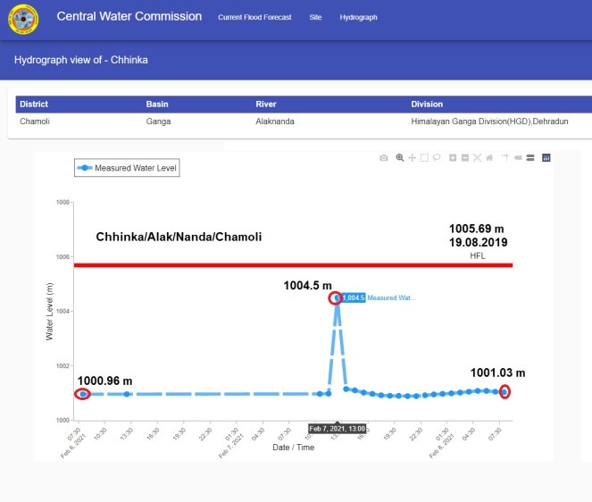
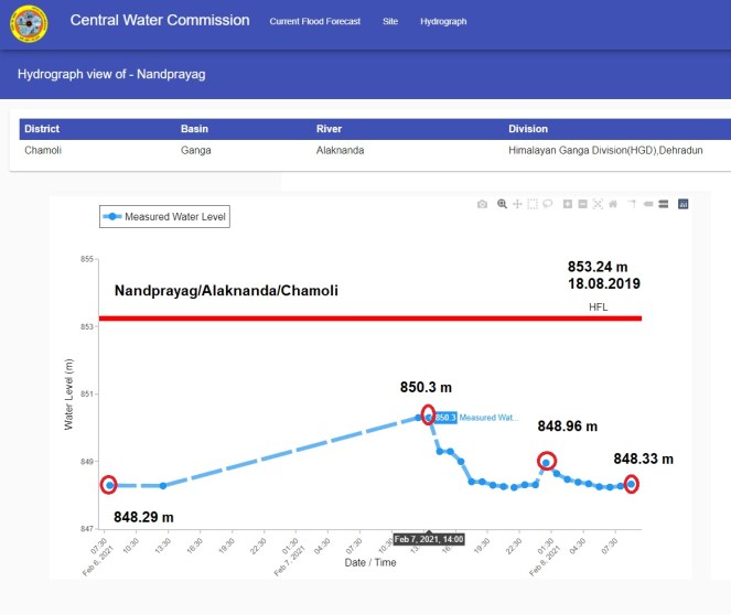
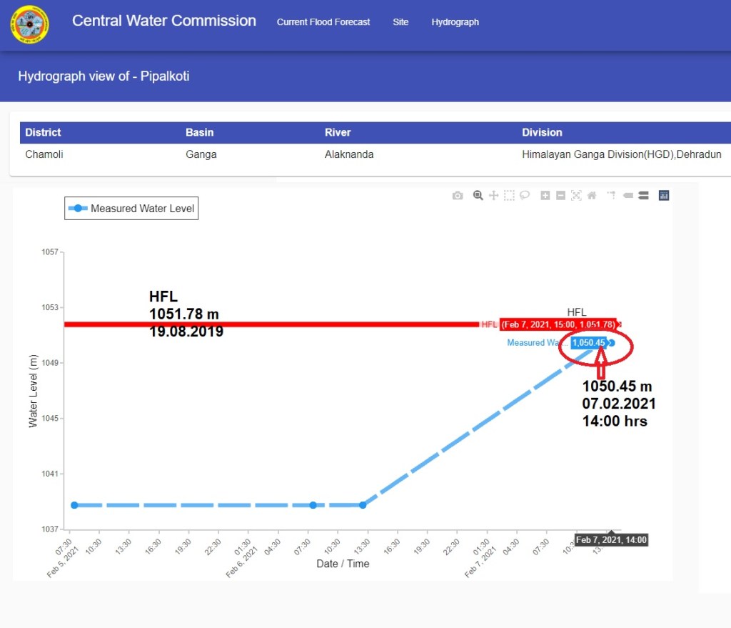

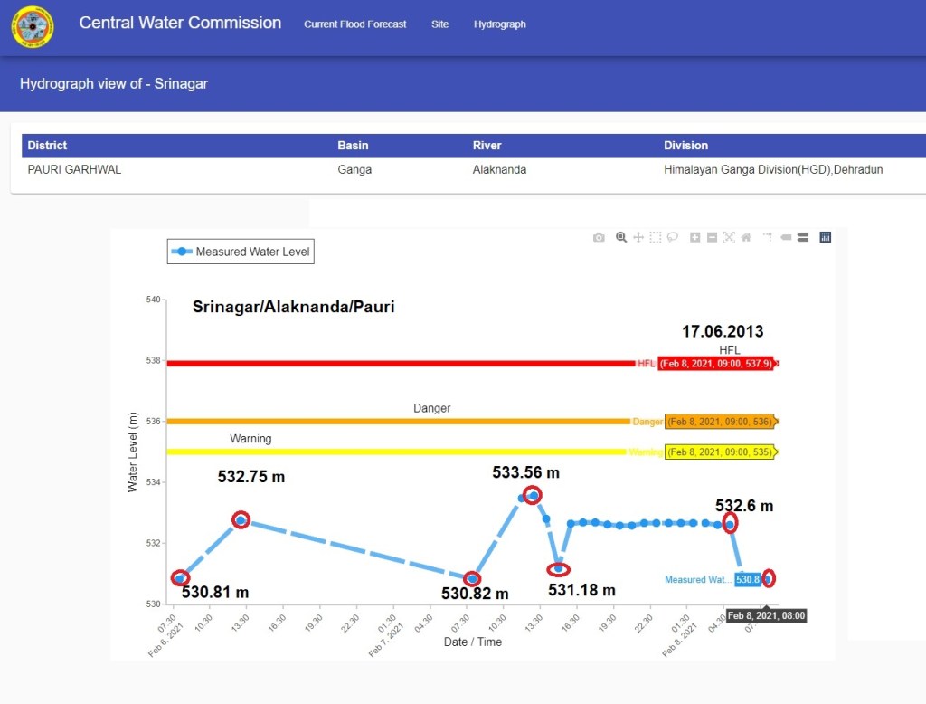
Hydrographs of flood monitoring sites along Alaknanda river upto Srinagar showing rise in water level following the flashflood on 07 and 8 Feb. 2021.
The available information reveals few noteworthy points. Firstly out of the 16 sites in the Alaknanda basin 13 have HFL dates recorded in just two years of June 2013 (7 sites) and August 2019 (6 sites). HFL dates for 2 sites are missing.
Interestingly the Badrinath area has suffered hugely during 2013 Kedarnath disaster, however the HFL level is shown of 2007. Similarly, while in 2013 deluge 6 sites have HFL date as June 17 but the Joshimath site has HFL date of June 28 which is 9 days after the severe flood. Possibly, CWC need to revisit the exact dates of HFL at Badrinath and Joshmath sites.
Significantly, this is the first time a site has breached HFL in non-monsoon season in the state. It is also evident that CWC does not have any functioning sites on Rishiganga and Dhauligana which could have helped timely responses in downstream areas. The debris sludge has also raised the riverbeds of Rishiganga, Dhauliganga, Alaknanda upstream Joshimath which needs to be factored in while establishing the new sites.
Strangely CWC sites are active only during monsoon season between May to October months, whereas the state has become prone to flash floods on account of GLOFs, avalanche, landslide dams, failure or mismanagement of existing dams and barrages.
The Chamoli disaster has caught CWC unaware and missing in action for 7 crucial hours. It has also provided several important lessons for the agency. Among them, firstly it certainly needs to set up more flood monitoring sites along smaller rivers in the state. Then round the year functioning of the sites is equally imperative. Of course, CWC still has long way to go to improve forecasting accuracy and data updating which we have been mentioning time and again. The points raised above can greatly contribute in aiding emergency responses during critical hours. One hopes, CWC would look into these issues positively in the wake of Chamoli flood disaster.
Bhim Singh Rawat (bhim.sandrp@gmail.com)
[i] https://blogs.agu.org/landslideblog/2021/02/08/chamoli-2/
[ii] https://ffs.tamcnhp.com/main/site
[iii] https://sandrp.in/2020/09/16/north-india-cwc-flood-forecasting-sites-2020-new-website-old-problems/

Earlier I thought all these govt agencies work together in coordination to make things happen or say save things from happening but I was wrong.
LikeLike