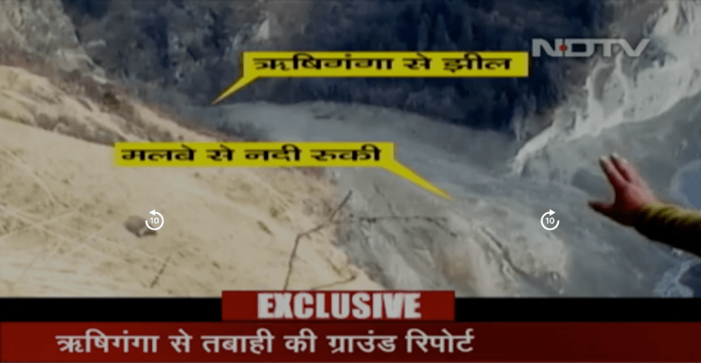
The first ground visit report of the Rishiganga catchment in Uttarakhand’s Chamoli district by Dr Naresh Rana, a geologist after the Chamoli Avalanche disaster of Feb 7, 2021 has been shared by NDTV on Feb 11, 2021[i]. Dr Rana visited the catchment of the Rishiganga to understand the ground situation on Feb 10 ,2021 and this is possibly the first such visit since the disaster.
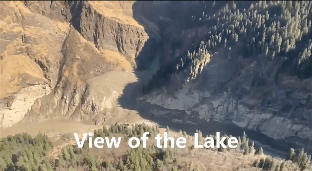
The most important revelation of the visit video is that the Rishiganga river flow was found to be completely stopped by an estimated 20-30 m high earthen dam made of the debris brought by the Ronthi Gad (river) at the confluence of Ronthi and Rishiganga rivers. As Dr Rana revealed, when this dam breaches, the water level in the downstream river would once again rise and there could be some risk to the personnel involved in rescuing some 35 people trapped in Tunnel No 1 of the under construction 520 MW Tapovan Vishnugad hydropower project of NTPC on Dhauliganga river, which has been almost completely destroyed by the avalanche flood on Feb 7, 2021 morning from the Rishiganga catchment.

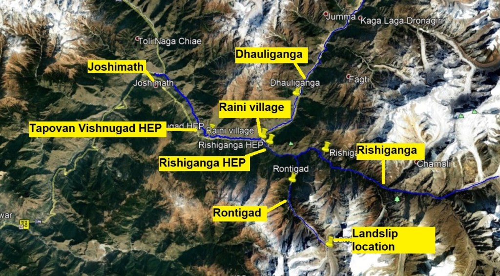
From a map prepared by Bhim Singh Rawat of SANDRP, we can see that the landslide dam site is 5.21 km upstream of the Rishiganga-Dhauliganga confluence. The location of the avalanche site is about 12.66 km upstream of the Ronthi Gad-Rishiganga confluence along the Ronthi Gad. The length of the reservoir behind the landslide dam or its volume is not known.
The government knew about the landslide dam, but did not share the information? In the discussion that follows on NDTV, well known geologist Dr. Navin Juyal makes an important revelation, not in public domain. He says that the government had done a helicopter survey of the Rishiganga catchment on Feb 9, 2021, so they must be knowing and were knowing about the existence of this landslide dam, but that key information was not made public and its only after Dr Naresh Rana visited the area that this came to public knowledge. Dr Rana’s colleague, Prof Y P Sundriyal of HNB Garhwal University similarly raised a number of issues and agreed with Dr Juyal that taking up projects like Tapovan Vishnugad and other such major interventions in this region is not advisable.
This then raises questions as to why did the authorities not share this crucial information about the landslide dam blocking the Rishiganga flow, what action did the authority take to ensure that this does not create another disaster for the rescuing personnel?
In a report on Feb 12, 2021, NDTV said: “Scientists of the Defence Research and Development Organisation(DRDO), the National Disaster Response Force (NDRF) and others are working on a plan to avoid another disaster, should water from this lake gush through a breach”. “This matter has been taken cognizance of. As we speak, teams are already on the way to the lake side to assess the situation, take a review. Earlier in the morning, teams have overflown the area in choppers and found out…. Even drones, unmanned flights, stakeholder agencies are doing the review of the exact situation on the ground,” NDRF Director General SN Pradhan said.
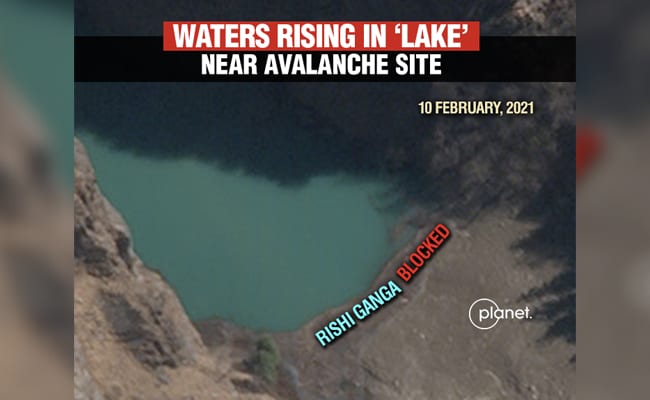
CWC shared a video of the landslide dam after we published this blog. The twit said the dam has length of 350 m height of 60 m with slope of 10 deg. Volume of water accumulated behind the landslide dam is estimated at 0.7 Million Cubic Meters. NDRF DG SN Pradhan said that the size is increasing with every passing day. NDRF has submitted the report about their visit to the lake to CWC. Satellite images have validated that this is new lake, formed post disaster of Feb 7, 2021. Some water has started flowing out from the lake on Feb 12 morning as can be seen from the CWC twitted images below. DRDO drones are collecting images of the lake every hour.
https://twitter.com/CWCOfficial_FF/status/1360134977950674944
Images Twitted by CWC on Feb 12, 2021.


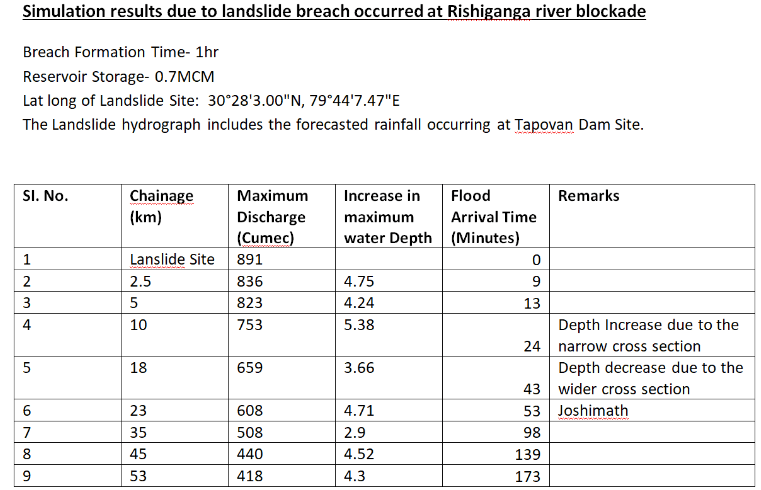
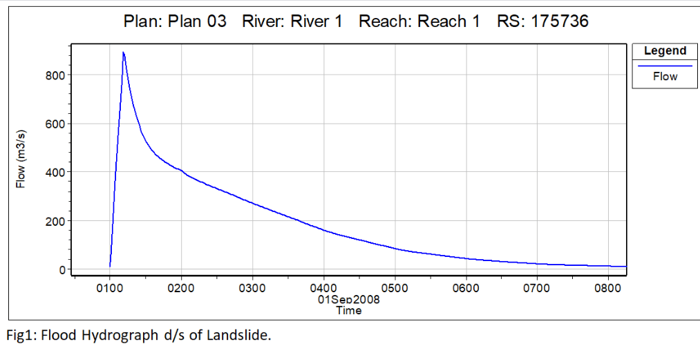
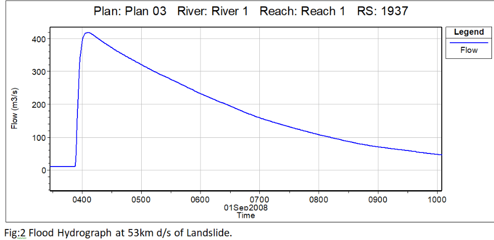
Simulation results from CWC about possible breakage of the landslide dam.
CWC’s hydrograph does not reflect ground reality? In fact, as per a report[ii], on Feb 11, 2021, the water level of Dhauliganga rose by about 3 meters around 2 pm and receded a few hours later. However, the CWC hydrograph on Alaknanda river at Joshimath (the only CWC monitoring site that is useful here since CWC has no monitoring site either on Rishiganga or Dhauliganga, they could have easily set one up in the aftermath of the disaster and the possibilities of the landslide dam and its breach in the upstream), just downstream of Dhauliganga-Alaknanda confluence.
As we can see, the hydrograph shows rise of about 3 m in water level around 1300 hrs on Feb 10, 2021 (strangely reported only post 5 pm on Feb 11) and has remained more or less steady till around 11 hrs on Feb 12, 2021, not showing any significant fluctuation on Feb 11, 2021 as reported in media and as experienced at site. This again raises many questions about CWC’s functioning and accuracy and usefulness of their reports[iii].
ISRO images silent about the landslide dam? On Feb 10, 2021, Indian Space Research Organisation (ISRO) shared first satellite images of the disaster area[iv] since the disaster on Feb 7, 2021, though one expected ISRO to share it more promptly. However, in these images, there is no mention of the landslide dam on Rishiganga river.
Does it mean ISRO could not locate this development in its satellite images? Since this looks unlikely, does it mean ISRO knew about the landslide dam, but did not share or was asked not to share? Why was was this not shared in public domain? Media also said that ISRO has submitted a report on Feb 10 to the Uttarakhand govt. Why has the ISRO or Uttarakhand govt not shared that report with people of Uttarakhand? In fact, earlier on Feb 8, 2021 too ANI, Amar Ujala and other media reported that ISRO had shared satellite images with Uttarakhand Chief Minister. Why did ISRO or Uttarakhand govt not share them in public domain? What is the use of all this disaster related information if it is not in public domain, since disaster management is a public interest activity?
Too many questions, for which there are no clear answers even in disaster management.
Himanshu Thakkar (ht.sandrp@gmaill.com)
[i] https://khabar.ndtv.com/video/show/news/uttarakhand-rishiganga-river-flash-flood-exclusive-photos-575400
[ii] https://timesofindia.indiatimes.com/city/dehradun/uttarakhand-glacier-burst-rising-waters-interrupt-rescue-effort-operation-resumes-after-all-clear/articleshow/80851489.cms
[iii] https://sandrp.in/2021/02/10/chamoli-disaster-cwc-needs-functioning-forecasting-beyond-monsoon/

As of we know that Wadia Institute for Himalayan Geology people said they didn’t have access to the region while they have govt tools at their dispense. While formation of such a lake was outrightly rejected on the first hand information. Whom we should believe.
And regarding Ndtv, I’m a long time viewer of it but recently, one of their senior journalists Nidhi Razdan was conned as she claimed on Twitter herself.
I’m just inquisitive about what happens to those people trapped in the tunnel and missing. Of those living in Reini and surrounding villages.
In the era of Internet, it’s both a tool for knowing as well as for doing other things where photos and videos get doctored.
Perhaps we should wait for some more information regarding the condition of the upper catchment area as false information can put people in jeopardy as they are already in trouble.
I just pray that the earthen dammed (if) gets a seepage through the moraine mass and there are no further damage to the already devastated local lives.
LikeLike
The info of the earthen dam comes from scientists and now confirmed by CWC and DRDO. Plz read the blog carefully.
LikeLike