Guest Article by S P Ravi
Kerala continues to witness unusual monsoon rainfall patterns for the third straight year in 2020. Kerala had witnessed its worst flood in almost a century in 2018. The 2019 flood was probably second only to the 2018 floods over the last 50 years, with many places experiencing larger floods than that in 2018. While the state did not face huge floods this year, tragedy struck in the form of the Pettimudi landslide near Munnar in Idukki district. It buried alive 70 members of plantation labourer families, making it the worst ever landslide in Kerala in terms of human causality. Kerala has also witnessed its wettest monsoon in September in this millennium with a rainfall of 601 mm, surpassing the previous highest of 526 mm recorded in 2007. The S-W monsoon period is now over and the state received 2227 mm rainfall, which is 9 percent above long term average.
The September rains briefly threatened the Chalakudypuzha river basin with a repeat of 2019 floods. However, this was avoided as the rain gods decided to smile upon the basin, halting abruptly, very heavy rainfall on the morning of 20th September despite IMD declaring red alert for many districts including Thrissur. The basin had got its best rains this year on August 6th evening and night with the upper dams recording 150 mm to 248 mm rainfall. Maximum discharge from the lowermost dam, Peringalkuthu on 7th Aug morning was about 730 cumecs. Peringalkuthu was forced to discharge about 670 cumecs on the 20th of September, even though the rainfall in most part of the upper catchments was less than 100 mm. While the upstream reservoirs absorbed almost entire inflow on August 6, three reservoirs opened their flood gates on the 20th of September. Reservoir operations during the monsoons continue to be a challenge on the people at Chalakudypuzha basin, even as it has improved substantially elsewhere.
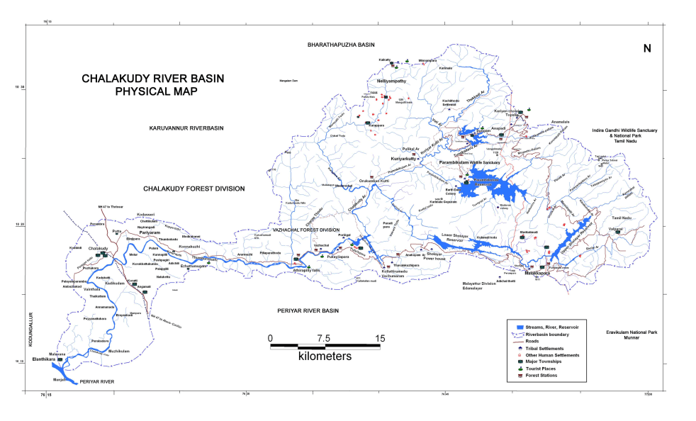
The Chalakudypuzha river basin Chalakudypuzha, the fifth largest river in Kerala originates from Valparai in the Anamalai hills of the Southern Western Ghats. Other major tributaries originate at the Parambikulam tiger reserve and the Nelliyampathy hills. This 144 kms long river has a catchment area of 1704 sq.kms, out of which 300 sq.kms is in Tamil Nadu. After traversing for about 135 kms, the river merges with the right arm of the Periyar river at Puthenvelikkara grama Panchayath in Eranakulam district and then flows together to empty into the Arabian sea at Azheekode near Kondungallur. Annual utilisable yield of the river was estimated at 2033 million cubic meter (MCM) as per the “Water Resources of Kerala” (GoK, 1974).
The river basin receives an average of 3000 mm rainfall annually, with the Valparai and Sholayar regions getting more than 4000 mm. The river has been dammed at six places (see Table-1) with the first one, the Peringalkuthu right bank hydro electric project built across the main river and the rest built across various tributaries.
Table 1 – Dams across Chalakudypuzha river
| Sl No | Name of dam | Year commissioned | Gross Storage MCM | Purpose | Controlled by |
| 1 | Peringalkuthu | 1957 | 32 | Electricity Gen | KSEBL |
| 2 | Thunakadavu | 1965 | 15.77 | Diversion | Tamil Nadu |
| 3 | Kerala Sholayar | 1966 | 153.49 | Electricity Gen | KSEBL |
| 4 | Parambikulam | 1967 | 504.66 | Diversion | Tamil Nadu |
| 5 | Peruvaripallam | 1971 | 17.56 | Diversion | Tamil Nadu |
| 6 | TN Sholayar | 1971 | 152.7 | Diversion, Ele. Gen | Tamil Nadu |
The first dam across the river, Peringalkuthu with a height of 26 m was commissioned in 1957. It has a total catchment area of 1000 sq.kms. Later, five more dams were built across various tributaries of the river as part of the inter-state Parambikulam – Aliyar Project (PAP). Four of these were built within the Kerala territories while the Tamil Nadu Sholayar is in Tamil Nadu, just above the inter-state border at Malakkapara. The Tamil Nadu Sholayar has a free catchment of 121 sq.kms and it gets diverted water from the Upper Nirar weir and Lower Nirar dam in the Periyar basin. The project has two powerhouses, a saddle spillway along the flanks of the reservoir and spillway shutters at the dam. Water from the first powerhouse and the saddle spillway are diverted to Parambikulam and that from PH 2 and spillway at the dam flows down to Kerala Sholayar. The Parambikulam dam is the biggest in the basin with a water spread area of 2000 ha. It receives water from its 228 sq.kms catchments and diverted water from TN Sholayar and Nirar. Entire water, except flood discharges are taken to Tamil Nadu via Thunakadavu. The twin reservoirs of Thunakadavu and Peruvaripallam are the smaller ones in the basin. They are inter-connected by a deep canal. Tamil Nadu’s share of water from the Periyar and Chalakudypuzha basins are diverted to the eastern side from the Thunakadavu through open canal and tunnel up to the Sarkarpathi power house and then through a 49 km long contour canal.
All these four dams were built by the government of Tamil Nadu and are controlled by them. Flood discharge from both Parambikulam and Thunakadavu will flow down to Poringalkuthu. Peruvaripallam has no flood gates, but since it is linked to Thunakadavu, excess water will flow down to Peringalkuthu. The Kerala Sholayar HEP is the only project built by Kerala as part of the multi-basin PAP. In fact this should not have been part of the PAP as it is not part of the main link, except for receiving part of the yield from TN Sholayar. The reservoir gets water from its own catchment (64 sq.kms) and a part of yield from TN Sholayar. Its tailrace water is let into Anakayam Thodu, a tributary of the river and flows directly to the Peringalkuthu reservoir. The spillway shutters will let the water into the river and it will reach the Peringalkuthu after traversing for about 28 kms. From flood management perspective, these five reservoirs can store / regulate inflow from an area of 474 sq.kms.
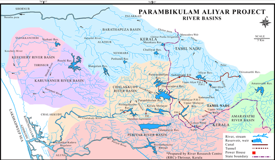
Operation of the Kerala Sholayar project is decided by the PAP agreement provisions, signed on the 29th of May 1970. Kerala is entitled to utilise a total quantity of 348 MCM (12300 Mcft) annually at the Kerala Sholayar power house in a water year (1st of July to 30th June). Additionally, there are provisions for maintaining specific water levels at Kerala Sholayar reservoir. As per these provisions, the Tamil Nadu Sholayar project should start releasing water to the lower dam from the first of July and bring the water level to about 5 feet below its full reservoir level (FRL at +2663 ft MSL). The reservoir shall be kept at FRL on the 1st of September. Between the 2nd of September and 31st January, the water level shall be maintained at about 5 feet below FRL. On the 1st of February every year; the government of Tamil Nadu shall ensure that the Kerala Sholayar reservoir is at FRL. No release need to be done from the TN Sholayar after the 1st of February, if 12,300 Mcft has been delivered at the Kerala Sholayar.
The 2020 monsoon and Chalakudypuzha basin
The rains failed the state again in June-July 2020 as in 2019, recording a shortage of 23 percent even though the forecast was for normal rainfall. This was more than made up in August and September and Kerala has received about 9 percent more rains at 2227 mm as on Sept 30, 2020. Based on the experiences of the previous years, a few civil society groups had jointly provided suggestions to the government, in early May for better monsoon preparedness and flood management.
At Chalakudypuzha river basin, various groups in the basin wrote to the local self governments and members of legislative assembly and parliament on steps that can be taken with regards to flood preparedness. One of the suggestions was to ensure that the upstream dams will not be opening their flood gates when the downstream basin is facing possibility of floods.
The upstream dams had contrasting roles with regards to the floods in 2018 and 2019. In 2018, huge release from the upstream dams had resulted in overtopping of the Peringalkuthu dam in the early hours of August 16th. Combined release from the Kerala Sholayar and Parambikulam dams had jumped from around 22000 cusecs during the day time of 15th Aug to about 30,000 cusecs by night and then to a peak of 72,000 cusecs by 4 am on 16th Aug. This was on top of the very heavy inflow into the Peringalkuthu from its 526 sq.kms free catchment, probably in the range of around 50000 cusecs, the figures are not available. Peringalkuthu has seven spillway shutters and four river sluices. Out of these two river sluices could not be opened and the maximum available flood discharge capacity was around 60,000 cusecs only. And, water was flowing at two meters above the dam. It is sheer luck that the 61 year old dam did not break.
The basin had experienced extremely heavy rains with the TN Sholayar dam recording 41 cm and Kerala Sholayar 35 cm rains on the 15th Aug 2018 and this certainly was the prime contributing factor to the huge floods. But it is undisputable that the five dams above Peringalkuthu, with a combined gross storage capacity of 844 MCM did not have a flood cushion of even one percent and hence these dams were forced to resort to very high flood discharges. The Kerala Sholayar reservoir that reached FRL on the 27th of July had remained at 100 percent from that day even though there was sufficient time for reducing the storage before the predicted high rainfall started. TN Sholayar was having water above FRL and was discharging water through its spillways. Only Parambikulam had a small space of about one foot and even with this small space some moderation was done on the 15th Aug. Flood discharge from Parambikulam on the 14th Aug was at about 11000 cusecs. With extremely heavy rainfall on 5th Aug, it should have gone up steadily. Instead, the release was contained in the range of 7000 – 9000 cusecs until the night of 15th to help in the rescue operations. This helped in providing valuable time for rescue of almost 60 – 70 percent of people, before water entered their home. If all the dams had sufficient flood cushion, the maximum flood water level would have been substantially lower and a large number of the 50,000 households that were inundated, would have been spared.
Unlike in other river basins, people involved with the river were continuously alerting the authorities about possibility of very large floods from the third week of July and had requested for all precautionary measures, including providing space in the dams. Unfortunately, these requests were ignored, for reasons best known to them.
In 2019, the upstream reservoirs absorbed the entire runoff from their catchments, except for a meager release of about 400 cusecs from Thunakadavu, helping in reducing the flood intensity. As stated earlier, the monsoon was not very active in June-July 2019 and the dams had low storages. With very heavy rainfall in the range of 20 – 27 cm at various locations in the upper catchments on the 8th Aug 2019, the discharge from Peringalkuthu had peaked at about 40,000 cusecs (about 1100 cumecs) in the early hours of 9th Aug, 2019. This, along with runoff from the downstream regions resulted in huge floods, second only to the 2018 floods, in recent times. If the upstream reservoirs had not absorbed about 35000 – 40000 cusecs, the flood could have been far worse affecting tens of thousands of houses additionally. Incidentally, the dams soon were full or close to FRL, but luckily for us, heavy rains did not affect the basin, even though some other parts of the state received very heavy rains in the later part of the monsoon.
Having said that the dams helped in regulating the floods in Aug 2019, I would request the readers not to take this as an endorsement for new dams in the name of flood control. The irreversible environmental, ecological and social costs of dam construction will remain same irrespective of whether it is built for hydro power generation, irrigation or exclusively for flood control. The only argument here is to utilise existing reservoirs for flood control/ moderation and also for drought mitigation, wherever possible.
In 2020, the upper rule level for Peringalkuthu reservoir with its FRL at +424 m MSL, was fixed at 419.4 m for the entire monsoon period. The storage at this level is about 60 percent of the gross capacity of 32 MCM. This is the crest level of the spillway shutters and it was decided that the shutters will be kept open and if required, the two available river sluices can also be operated. Accordingly, blue alert level was fixed at 417m, orange alert at 418 m and red alert at 419 m. (We had actually requested to limit maximum storage at the reservoir to less than 50 percent of its capacity considering the large catchment area for the small reservoir. However, this decision still was a big improvement on the earlier practice of opening the shutters after the dam water level reaches FRL only.) The dam was being managed accordingly until the first week of September.
At Kerala Sholayar, the blue alert level is 2658 ft, orange alert at 2659.5 ft and red alert at 2661 ft MSL. Rule curve at this project was not prepared on the basis of flood possibilities. According to authorities, they were constrained by the PAP agreement and prepared the rule curves in accordance with the agreement. Considering the fact that this dam is in high rainfall region and the upstream TN Sholayar is capable of releasing huge quantities of water, we had requested for restricting the storage to a maximum of 75 percent of its capacity during the South – West monsoon period. Kerala Sholayar had the maximum flood discharge among the upstream dams during the 2018 floods at above 40000 cusecs.
As already mentioned, the basin got its highest rainfall in 2020 SW Monsoon on the 6th of August. The high rainfall spell started on the 3rd of August and the upstream dam sites were particularly recording fairly high rainfall. Analysis of this spell would help in appreciating the need for disaster risk reduction measures that should have been taken during the September rains. Rainfall recorded at the five upstream dam sites between the 3rd and 8th of August is provided in the table below. (Since the time of recording rainfall is 8.30 am, the dates are from 4th to 9th.)
Table 2 – Rainfall in mm recorded at upstream dam sites
| Date | K Sholayar | TN Sholayar | Parambikulam | Thunakadavu | Peruvaripallam |
| 4/6/2020 | 100 | 126 | 70 | 47 | 60 |
| 5/6/2020 | 88 | 130 | 65 | 52 | 63 |
| 6/6/2020 | 50 | 107 | 68 | 71 | 75 |
| 7/6/2020 | 171 | 248 | 175 | 150 | 150 |
| 8/6/2020 | 87 | 110 | 62 | 52 | 58 |
| 9/6/2020 | 48 | 41 | 37 | 47 | 52 |
| Total | 544 | 762 | 477 | 419 | 458 |
Five day cumulative rainfall between the 3rd and 7th of August recorded at Tamil Nadu dam site was very high at 721 mm with the rain from 8.30 am on the 6th to 8.30 am on the 7th being 248 mm. Incidentally, the total rainfall recorded at the dam site in June and July was 1234 mm. Kerala Sholayar dam site had five day cumulative rains of 496 mm with the rain on August 6/7 being 171 mm. Parambikulam had 175 mm rain on August 6/7 and both Thunakadavu and Peruvaripallam recorded 150 mm each. Parambikulam, Thunakadavu and Peruvaripallam recorded five day cumulative rainfall of 440 mm, 372 mm and 406 mm respectively.
Peringalkuthu was already spilling a small quantity of water through the spillway from the 31st of July as the water level had crossed 419.4 m. There was small spill on a few days in July too, which is normal for the reservoir. With increase in rainfall from the 3rd August and with prediction for more intense rains, the sluice gates were also opened to regulate the anticipated inflow. By afternoon on 6th Aug, water level at Peringalkuthu had been reduced to 415.25 m. Inflow into the dam at that time was in the range of 300 – 350 cumecs. After 3 pm, there was sudden rise in inflow and the water level began to rise rapidly despite releasing about 380 cumecs through the sluices and powerhouse. By 10 pm it reached 419 m and soon went above 419.4 m and water started to flow through the spillway shutters too. At 4 am, on the 7th Aug, the water level was at 421.1 m and the total outflow had increased to about 730 cumecs (376 cumecs through sluices, 322 cumecs through spillway shutters and 30 -31 cumecs through PH). This resulted in inundation of some low lying regions and relief camps were opened at many places. With orange alert for the day and red alert for the next day, there was fear of larger floods. However, the rains reduced and the discharge came down to about 600 cumecs by 10 am on Aug 7 and then to less than 500 cumecs by afternoon. Rains reduced considerably on 8th Aug, and the flood threat was averted for the time being. Cumulative inflow into the five upstream reservoirs from 8 am on the 6th Aug to 8 am on 7th Aug was 2200 Mcft (62 MCM). Had this not been absorbed by these dams, the inflow into and corresponding outflow from Peringalkuthu would have gone up to more than 1400 cumecs.
September was unusually wet for Kerala. The state had two good rainfall spells from the 6th Sept and 18th Sept. Rainfall in the range of 6 – 10 cm was being recorded at many places in the first spell. During the second high rainfall spell, a couple of locations in Kozhikode district recorded more than 20 cm on the 19th and a few other locations had rains between 10 cm to 16 cm. At Chalakudypuzha river basin, Chalakudy and Peringalkuthu had 112 mm and 104 mm rainfall respectively and the upper catchments had rains between 39 mm at Thunakadavu and 94 mm at Kerala Sholayar. cumulative rainfall on 19th, 20th and 21st of September was also substantially less, when compared with that on the 5th, 6th and 7th of August. The chart below shows comparative three day cumulative rainfall in mm on 5/6/7 of August and 19/20/21 of September.

TNS – TN Sholayar, KS – Kerala Sholayar, PKM – Parambikulam, TKU – Thunakadavu, PPM – Peruvaripallam
19th September 2020 Orange and yellow alerts were declared at many districts for four days from 19th Sept. At 1pm on the 19th, IMD upgraded the yellow alert for Thrissur district to orange for three days and enhanced the alert level to red for three districts, suggesting possibility of very heavy rains. Water level at Peringalkuthu at 3 pm on 19th Sept was 423.65 m and a controlled spill of 136 cumecs was being released through the spillways. By 4 in the evening, two upstream reservoirs opened their flood gates and started releasing water to the river. Parambikulam started releasing 1600 cusecs (about 45 cumecs) and Kerala Sholayar, which had a storage level of 2662.55 ft (against FRL of +2663 ft) began flood discharge at 100 cumecs. As these waters started reaching Peringalkuthu, spillway shutters at Peringalkuthu were raised slightly and the flood release at 10 pm on the 19th was 235 cumecs and together with powerhouse release, the total discharge was at around 265 cumecs.
20th September 2020 Throughout the night of 19th Sept 2020, most part of the basin was experiencing very good rains. Very heavy rains on the morning of 20th Sept had briefly brought memories of the previous years. Luckily, the rains stopped by around 10 am. Spillway shutters were being raised at Peringalkuthu in steps and the total discharge increased to about 355 cumecs at 9 am and to 585 cumecs by 12 noon. Meanwhile, release from Kerala Sholayar was enhanced to about 195 cumecs and that from Parambikulam to 112 cumecs. It was finally decided that a river sluice at Peringalkuthu too will be opened at 2 pm. IMD converted orange alert for the day to red alert and orange alert for 21st Sept continued. By 7 pm, the discharge from Peringalkuthu peaked at more than 670 cumecs (449 cumecs through spillways, 190 cusecs through sluice gate and 31 cumecs from the powerhouse). The day recorded maximum flood release from Peringalkuthu this year at 43.856 MCM. On the 7th August 2020, the flood release was 42.283 MCM.
Even though the upstream reservoir releases remained high on 21st Sept too, the rains had come down and the discharge from Peringalkuthu reduced from about 550 cumecs in the morning to about 430 cumecs by night. With the high rainfall spell coming to an end, the flood threat was finally over for the S-W monsoon 2020.
The above discussions show that the flood releases from Peringalkuthu were almost similar on August 7th (maximum 730 cumecs) and September 20th (maximum 670 cumecs), even though the rainfall on September 19/20 was only about half of that on August 6/7. The difference obviously was the release of about 400 cumecs from Parambikulam and Kerala Sholayar reservoirs into the Peringalkuthu. This could and should have been completely avoided. We shall look into management at Parambikulam, Kerala Sholayar and Peringalkuthu reservoirs.
Inadequacies in reservoir management with respect to flood control
Flood management at Chalakudypuzha basin is a bit complex as four of the six dams, with a combined catchment area of 410 sq.kms are controlled by the Government of Tamil Nadu. Flood management was not a point of consideration in framing the Parambikulam – Aliyar Project Agreement that governs the water sharing from these dams. Given the role of these dams in releasing huge quantity of water during the 2018 floods, Kerala should have engaged with its TN counterpart and arrived at steps to avoid similar situations in future. (This is applicable for the Mullaperiyar dam in Periyar basin too.) It is not known to the public whether the Kerala Government has taken any initiatives in this regard.
In the submission to people’s representatives of the river basins, concerned organisations had requested that rule curves, standard operating procedures (SOPs) and emergency action plans (EAPs) shall be made for these dams too. It was suggested that the water storage at Parambikulam dam shall be restricted to a maximum of 80 percent of its storage capacity up to the 15th of August (or 31st, in case of forecast for more rains) and at 90 percent during North – East monsoons. At Thunakadavu and Peruvarippallam we had requested to restrict the maximum water level to five feel below FRL. With regards to TN Sholayar, it was requested that the government should engage with its counterpart and prepare rule curve to ensure adequate flood cushion. Obviously, these requests did not yield any results.
At Kerala Sholayar, it was requested that the storage shall be restricted to a maximum of 75 percent during the entire South – West Monsoon period. The rule curves prepared by the Kerala State Electricity Board Limited (KSEBL) unfortunately did not provide for any flood cushion, saying that it was prepared in accordance with the PAP agreement. It should ideally have prepared rule curves as per the requirements for flood management during monsoon. It could then have referred the conflicts with the PAP agreement, if any, to the state government. In fact, the agreement does not specify water levels for July and August, even though it says the Government of Tamil Nadu should bring the water level to about five feet below FRL at the earliest, which is seldom followed. This author had mailed a submission to the Thrissur district collector on the 12th August 2020, appreciating the efficient management during the high rainfall event from the 3rd to 8th of August and requesting to maintain flood cushion at upstream reservoirs and also to enhance electricity generation at Kerala Sholayar.
Between the 12th and 31st of August, the KSEBL actually generated only 5.36 million units at Kerala Sholayar with a corresponding water discharge of 8.04 MCM. They filled the reservoir on August 31st, apparently to fulfill the agreement provision that the Kerala Sholayar shall be kept at FRL on the 1st of September. Two 18 MW generators were available at that time and a daily electricity generation of 0.864 MU was possible. 16.42 MU of electricity could have been generated in 19 days resulting in utilisation of 24.6 MCM water. This would have created a storage space of about 11 percent, without even resorting to controlled release. It shall be noted that the responsibility of filling the Kerala Sholayar on two specific dates, the 1st of September and the 1st of February lies with the Government of Tamil Nadu and not with Kerala and hence there is absolutely no justification for KSEBL to have reduced generation to fill the reservoir. (The provision for filling the reservoir on the 1st of February is of prime importance for the river dependent people as it would ensure minimum water availability during summer months. However, the Government of Tamil Nadu has violated this on more than 80 percent years since the agreement was signed in 1970.)
The spillway shutters that were damaged during the 2018 floods finally got repaired after two years and the dam authorities decided to fill the Peringalkuthu reservoir in the second week of September 2020, apparently to test the efficiency of the spillway shutters. Consequently, water level in the reservoir began to rise from 9th September, even though the basin was getting good rains. It was only after protests from downstream people that they opened the shutters a bit on 12th. Shutters were closed again on 14th after the rains reduced and the reservoir was at full level on 15th Sept. It remained at close to FRL till the 18th Sept, even though increased rainfall activity was forecast for four days from the 18th. Finally, they were forced to open the spillway shutters on the 19th Sept and a river sluice too on the 20th Sept. The filling up of the reservoir was clearly in violation of the upper rule level at 419.4 m and the decision to keep the spillway shutters open during the monsoons. This was also in complete violation of the steps required to take during orange and red alerts. (One could have appreciated the need for testing the efficiency of the shutters, if it was done when there was no risk of floods. Also, they should have taken prior permission from all concerned authorities and this should have been intimated to the public, especially since this is against the provisions of the rule curve.)
The state certainly has learned a lot of lessons from the 2018 and 2019 floods. The Local Self Governments (LSGs) and Fire and Rescue and police force are now well prepared to deal with flood situations. (In fact they were the unsung heroes during the 2018 floods as they had shifted majority of affected people, before the water entered people’s houses.) District disaster management authorities are also better prepared. This year, the local self governments at Chalakudypuzha basin had taken all necessary precautionary measures, including shifting vulnerable families and cautioning others, setting up camps etc during both high rainfall spells. However, there is still a long way to go. Disaster risk reduction is not given the prime role it deserves; precautionary principle is not applied on many instances and more importantly, no measures are coming forth for preserving the ecologically fragile Western Ghats, which is paramount to the state’s survival.
Major dams including Idukki, Idamalayar, Kakki and Banasurasagar have been provided some flood cushion now. However, smaller dams continue to be neglected. More importantly, there is not even a single integrated reservoir management plan for multi dam basins. Flood models incorporating maximum variables possible and actionable flood prone area maps are not available in public domain. There is not even a single river basin level flood management plan.
Along with preparing rule curves, SOPs and EMPs (Emergency Management Plans) for even the smaller dams and integrated reservoir management plans at multi dam basins, reservoir management need to be made participatory with involvement of LSGs and other stake holders and experts.
After 2018 floods, river conservation groups at Chalakudypuzha, Meenachil River and Bharathapuzha are doing people’s monitoring during possible flood times. These initiatives are highly appreciated at ground level by communities, LSGs etc. One of the suggestions given to the government and peoples representatives was to develop a participatory real time flood monitoring mechanism. One or two teams of volunteers/ experts can be constituted and placed at strategic locations. Real time data on rains, river flow, reservoir storages and releases etc. shall be made available to the team and they shall be equipped with flood models and flood prone area maps.
Many river basins in the state normally get moderate floods on one or more occasions even during normal monsoon years. These floods perform some crucial ecological functions and people were used to these floods. However, the 2018 floods and the repeat floods in 2019 has now made people afraid of even small floods. With the climate crisis deepening rapidly, and real possibility of extreme rainfall spells becoming the new normal, irrespective of the overall volume of monsoons, efficiency of flood management has to be enhanced substantially. More importantly, people shall be made an integral part of flood management so that they know which flood is normal and which flood can become severe and act accordingly.
S P Ravi (spravi.18@gmail.com), Chalakudypuzha Samraskhan Samiti and River Research Centre, Thrissur, Kerala
