
Guest blog by: Madhusoodhanan C.G. and Sreeja K.G
The state of Kerala experienced extreme precipitation events during the 2018 South West monsoon period with multiple episodes culminating in devastating floods across the state during 14th-18th August 2018. This year, with an early onset of monsoons that dovetailed with strong summer showers, the state received about 41% excess rainfall (2394 mm against the normal of 1700 mm) during the period June 1st to August 22nd [1]. Almost all of its reservoirs were near full storage by mid-July.
The heavy downpour and the uncontrolled opening of the spillway gates of almost all reservoirs that inundated huge stretches of river banks and floodplains, along with massive landslides across the Western Ghats affected more than 1.5 million people, with close to 500 human casualties, immense losses to property, livelihoods and resource security apart from the extensive damage to forests, wildlife and biodiversity. Maximum destruction was observed along the rivers of Periyar, Chalakudy and Pamba, all having multiple dams on their tributaries. The debate is still on as to the various reasons, both manmade and natural, behind the floods and the resultant wide-ranging casualties [2,3,4,5,6]. Meanwhile things have taken a rather unexpected turn in the flood ravaged state.
Disappearing waters: Can there be drought in the wake of floods?
In the aftermath of the flood, rivers and wells of Kerala are experiencing unforeseen changes. Within days after the floods, there is a dramatic decrease in river flow and most of the lower order streams are also drying up alarmingly.
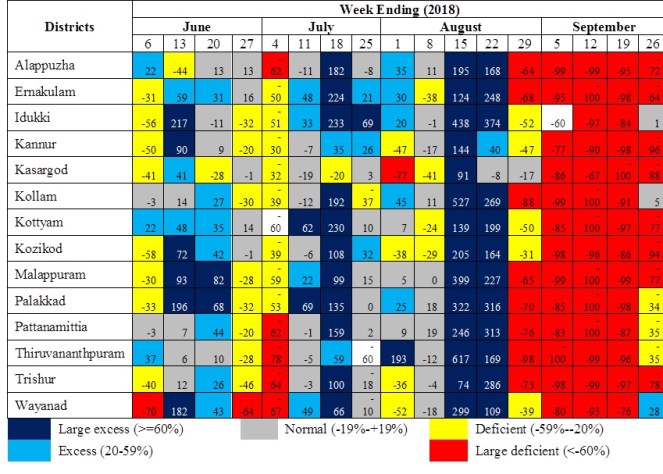
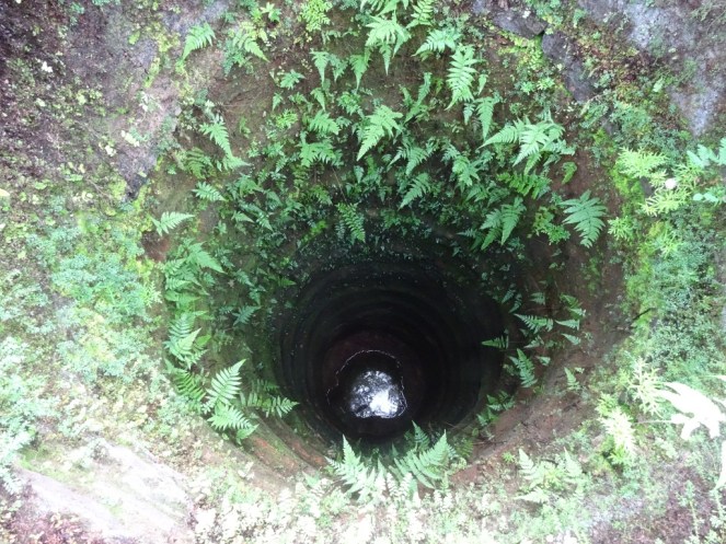
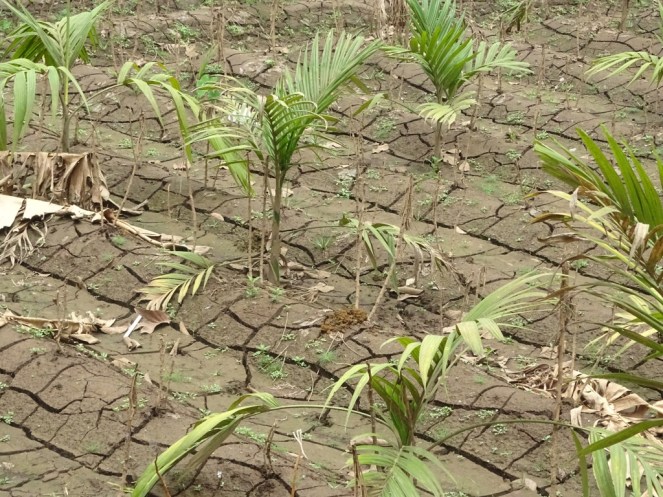
After the downpour of August third week, there was an abrupt break in the monsoons. The state faced an exceptionally long (20 or more days) dry spell as is evident from the district-wise weekly rainfall departures in Kerala provided by India Meteorological Department (IMD) (Table 1 below). This unexpected long dry spell has led to further receding groundwater levels, continued reduction in river water flows and opening up of deep cracks both in the hills and floodplains (see Photos 1-3). Open wells, which are a major source of drinking water show sudden drawdowns across the state. These indicators are deeply disquieting. The state may have to prepare for a severe drought, even if it receives a normal North East Monsoon (480 mm) this year. (The NE monsoon rainfall of Kerala during 2018 was 464 mm which is 3% below normal. https://www.imdtvm.gov.in/images/cumulative%20rainfall%20for%20kerala%20-%20ne%20monsoon%202018.pdf)
Unlike floods, drought is distinct due to its longer evolving time. It normally manifests as a result of the reduction/absence of precipitation for a longer period of time. It is therefore difficult to conceive of drought immediately after torrential rains and floods. Besides, our experience is that of flood enriched flood plains and ground water recharges which ultimately increase the water availability in the flooded regions. So it is natural to wonder at or even dismiss probable drought warnings after ferocious floods as far-fetched or even irrational.
Table 1 Weekly rainfall departures in Kerala during June- Sept. 2018 (Data source: IMD)

Scientific opinion differs on this peculiar phenomenon of decreasing water levels. The Centre for Water Resources Development and Management (CWRDM), a state government nodal agency attributes the falling water levels in the rivers to heavy leaching of top soil from the hills that have resulted in siltation of the rivers downstream[7]. Moreover, the floods failed to replenish ground water reserves. The Kerala State Land Use Board (KSLUB) is of the opinion that the river beds themselves have been eroded of their silt deposits by the heavy flood waters which have robbed the rivers of their natural characteristics and thus the drop in water levels. They also add that what we witness is not drought[8]. In effect, while one agency claims siltation to cause water level lowering, the other blames it on de-siltation.
Are we missing something here? The answers to the apparently contradictory river behaviour can only be sought through a thorough consideration of the hydrological processes that dictate water flow in the fragile hills of the Sahyadri (Western Ghats). This article is an explanation from a hydrological perspective for the lowering river and well water levels across the state of Kerala immediately after the floods.
How does rainfall become streamflow along the hillslopes?
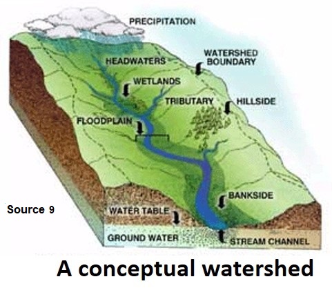
Streamflow is derived mainly by processes operating beyond the stream channels. The transformation of precipitation into streamflow takes place in the land area between the watershed divide and the stream channels. The rain that falls over a watershed can be obstructed by the tree canopy or can directly fall on the soil. Depending on the condition of the soil, it can flow over the soil surface or can be absorbed partially/ fully by the soil. The water absorbed by the soil may i) meet the evaporation and transpiration (ET) requirements of vegetation and return to the atmosphere, ii) reach the streams, iii) get stored as soil water, groundwater or as deep aquifer which may or may not later join the streamflow.
The streamflow itself can be developed from multiple pathways within a catchment/watershed. Various theories have emerged over the years conceptualising the processes of runoff generation in the hillslopes. The nature and source from which the flow is generated is used to differentiate the flow paths as i) infiltration excess overland flow, ii) partial infiltration excess overland flow, iii) saturation excess overland flow, iv) subsurface storm flow, v) perched subsurface flow and vi) delayed ground water flow (See figure below for specifics of each flow path).
Exact partitioning of streamflow according to its source and mechanisms are much more complex and still remains a challenge due to the heterogeneity in the physical features of watersheds. The dominant processes may even vary during and between the rainfall events, depending on antecedent soil moisture, rainfall intensity and soil permeability. These processes are interdependent and any number of them can operate within a hillslope during a given precipitation event.
The pathways by which streamflow is generated directly influence the flow regimes, nature and formation of floods, landslides and droughts. In the unique hydro-climatology of the Western Ghats, these processes are still very little studied and understood.
How do runoff processes in the Western Ghats differ from other regions?
The west coast of India and the Western Ghats in particular receives a huge amount of rainfall, thrice the national average, mostly (60-85%) during the South West monsoons (June-September). The average precipitation of the western slopes of the Western Ghats is as high as 3000 mm annually which can vary regionally between 2000 to 8000 mm, with multiple active and break spells. The abundance of energy in this humid tropical region results in very high plant biomass and highly weathered, permeable, and well-drained soils. These soils, especially in the rain forests with multi-tiered thick canopy cover, have astonishing infiltration capacities (as high as 700 mm/hour), able to absorb the entire precipitation that falls therein (even during extreme precipitation events).

In spite of the heavy rainfall, infiltration excess overland flow is a rare phenomenon in the undisturbed forests of the Western Ghats. The water that enters into the soil column moves through various complex pathways (see figure below). A part of the soil water continuously feeds the vegetation by providing for the evapo-transpiration (ET) requirements, which amounts to 900-1200 mm on an annual scale, depending on the rainfall. During extreme (both high and low) rainfall years, ET will be low and in normal rainfall years, it will be high. This apparent contradiction is due to the conditions of low energy availability during the high rainfall (extensive cloud cover) and reduced water availability during the low rainfall years. Most of the remaining active soil water storage is transformed into runoff due to the impermeable igneous strata particular to the Western Ghats.
| Hydrologic flow paths in hill slopes | Soil pipes in the Western Ghats |
|
|
|
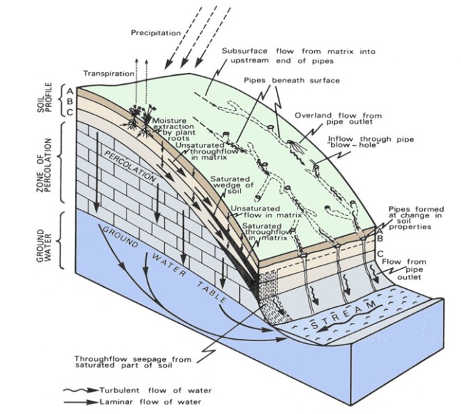

During the initial phase of the monsoons, the entire water will be absorbed by the soil and it will be recharging the groundwater resulting in elevated groundwater tables. There will be a steady increase in the streamflow during this period, derived as through-flow from these groundwater reserves. Once the water table approaches the surface, multiple flow pathways will be activated including soil pipes. Prof. Mysooru R.Yadupathi Putty who has conducted extensive field studies in Karnataka on the phenomenon of pipes and the unique hydrological processes in the Western Ghats, observes that the contributing area for pipe flow increases with the magnitude and duration of rainfall. While the contribution from pipe flow to streamflow is in the range of 15 – 25% for shorter duration (one day) rainfall events, it can be as high as 60% for longer duration (four to five days) events[13,14,15]. This is directly reflected in the streams as an abrupt increase in streamflow. During such periods, even a short break in the rains does not reduce the streamflow drastically.
If high rainfall persists under elevated groundwater conditions, flood occurs. Rainfall-runoff analysis in the Western Ghat river basins shows that present day rainfall alone is unable to explain the variability in daily runoff in the Western Ghats while inclusion of 25-day antecedent soil moisture index provides a much better understanding, indicative of the delay in conversion of rainfall to runoff in the Western Ghats[16]. Thus, rarely will the rains over the Western Ghats reach the sea within 24 hours, contrary to the popular myth and at times even scientific rendering based solely on the steep topography of the Ghats.
Hence, the flood experienced in the Western Ghats mainly through sub-surface storm flow is quite different from the flash floods typically derived from infiltration-excess-overland flow. The prevailing concepts to assess the propagation and magnitude of floods such as (i) time of concentration (ie. the time taken by the rain water to flow from the most remote point in a watershed to the outlet), (ii) runoff coefficients (for converting rainfall to streamflow) and (iii) unit hydrographs (direct flow resulting from one unit of constant intensity uniform rainfall over the entire catchment), thus become invalid in the Western Ghats.
Finally, why are rivers and wells getting dry after the floods?
This year (2018), apart from the early onset, the southwest monsoon was highly active during the initial phase, contrary to its normal behaviour. By the end of the second week of July, all streams were flowing bank full, almost all the reservoirs were at their full storage capacity and well water levels were almost at the soil surface. The rainfall received in the forested hills and slopes of the Western Ghats flow through the soils and not as overland flows above the ground surface, as discussed earlier. Due to the high porosity of the soils, water infiltrates vertically down through the soil column and recharges the ground water. Once the ground water levels are above a certain threshold (ie. near the surface) water will be released through the numerous natural micro/ macro soil pipes which are present near the surface. Saturated soil water gets drained safely through the hill slopes towards the stream banks through these soil pipes. Water can move laterally through these pipes much faster than through the soil matrix.
By the end of July, soils in the hills and slopes of the Western Ghats and plains were super saturated. The heavy spell of rains in August third week, after a short break in the preceding weeks, put more pressure on these soil pipes and initiated soil erosion leading to increased size and water carrying capacity of the pipes. The increased size of the soil pipes (due to soil erosion) drained out more water at much faster rates than normal.
The increased size did provide safer passages to the excess waters thus preventing the total collapse of these fragile hill slopes across the Ghats. Massive land subsidence is reported in places (Idukki, Wayanad, Thrissur and Kannur districts) where excessive soil pipe erosion may have occurred. The sites of occurrence of landslides are also seen to be mostly confined to stream channels/ lineaments, where there is maximum water pressure from soil pipes. Apart from the stream channels, landslides were severe in the slopes with high human intervention where these natural soil pipes may have been seriously damaged. The tremors from extensive stone quarrying across the Western Ghats and dam impounded waters can also affect the stability of the hill slopes, triggering/ intensifying the landslides. These landslides resulted in sudden release of stored soil waters, leading to immediate drawdown of groundwater levels in these regions.
The discharge from the soil pipes into the stream/ river channels along the banks are regulated by riparian vegetation that play a crucial role in controlling the discharge velocity of streamflow. These have been completely wiped out by the torrential flood flows/ landslides and by the sudden massive release of waters from the dams. Absence of these natural flow regulators results in uncontrolled release of sub-surface water into the streams/ rivers, again adding to the accelerated depletion of active soil water storage.
The extensive sand mining in the downstream stretches of the rivers of Kerala for the last four decades has resulted in lowering of river channels and water table along the river channels. Multiple barrages and regulators were constructed to maintain water levels in the rivers and to prevent salt water intrusion into the lowered channels. Most of these downstream barrages/regulators acted as a barrier during the flood due to improper operations and aggravated the flood impacts. Immediately after the floods, water in the river channels drained at a faster rate through the open barrages and regulators and reduced the river and river bank water levels.
 |
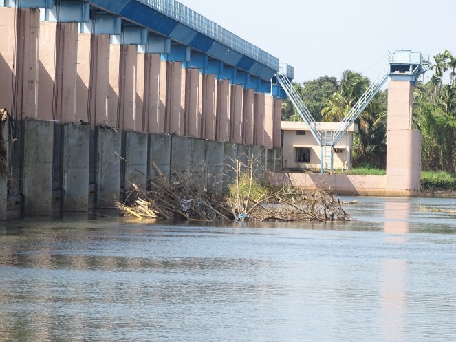 |
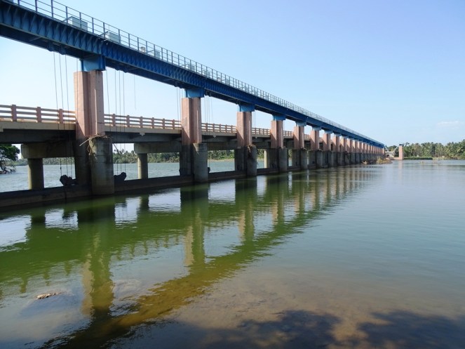
| Purappillikavu regulator-cum-bridge in the downstream of Periyar River. During the flood, the shutters of the regulator could not be fully opened since the control room itself was inundated first. After the floods, water continued to flow out as some of the shutters clogged by debris could not be completely lowered. (Photo: Madhusoodhanan C.G. and Sreeja K.G) | |
After the rainy season, the water availability in the region is dictated by the processes that hold water in the soil and make it available through discharges into streams/ rivers/ groundwater flow. In the rainless period (December to May), after meeting the evapo-transpiration requirements, the active soil water storage releases water to streams following an exponential decay until active storage is exhausted. The enlarged soil pipes, massive loss of stored soil waters due to landslides and extensive destruction of riparian and riverine vegetation is fast depleting this active soil water storage that normally helps tide over the rainless periods after the monsoons. Therefore, even if we receive good northeast monsoon rains, there is a high possibility for an extreme drought condition across the state. The severity of the drought will vary from place to place depending upon the hydro-geology.
How we can prepare for a possible drought?
Drought is different from flood. It takes longer time to evolve, is more insidious in its impacts and is a silent killer. The social dimensions are far more complex, creating resource conflicts and aggravating marginalisation. Hence, it is important to take measures well in advance to understand, monitor and prepare for a possible drought and its multi-faceted impacts.
The Govt. of India introduced the Disaster Management Act in 2005 for preparing, preventing, mitigating and managing risks of extreme events and disasters (both natural and manmade). The Act gives immense powers to the Disaster Management Authorities (DMAs) for ensuing timely and effective response to such eventualities. DMAs are responsible for preparing state and detailed district level disaster management plans which should also be reviewed and updated annually. Unfortunately, the State/District Disaster Management Plans (DMPs), published only in 2016, are highly inadequate to deal with the drought that we are going to face. These have neither been reviewed nor updated annually. Lack of preparation/inaction/late action from the DMAs can cause havoc and immense suffering to the people and the state’s economy. The present situation provides an opportunity to the DMAs to review and update the DMPs through Local Self Governments (LSGs), ensuring people’s participation and using their expertise.
The experience from the Kerala flood 2018 provides valuable pointers towards preparing for such eventualities in the future. Some of the areas that require immediate and urgent attention and research focus in the wake of a drought are:
- Give clear and early warning to public about the possibility for a severe drought and plan public involvement in drought mitigation planning and activities (including the DMPs).
- Drought and flood vulnerability mapping – identify drought and flood prone areas well in advance; panchayath resource maps prepared by the Kerala State Land Use Board provide information on perennial and non-perennial wells in each of the panchayaths. The drought prone areas can be marked with the aid of these maps. Special consideration should be given to such regions as they give us early warnings on the intensity of the drought which we are going to face. This exercise needs to be undertaken on a participatory basis, involving the strong voluntary local groups that were proactive during the floods. All these activities should be co-ordinated by the District Disaster Management Authorities and the LSGs.
- Prepare short and long term action plans to combat drought in these identified hot spots.
- Reducing the water demand by promoting conservation practices. Water is a part of the complex and dynamic Energy-Land-Water-Climate-Ecosystem nexus[17]. Use of energy and land and the variability in climate dictate the availability and use of water in a region. Hence, promotion of conservation practices in energy consumption and in the use of water on land (agriculture, household, industry etc.) will help in reducing the nexus demands on water.
- Effective use of the approaching north-east monsoon rainfall. The watershed management practices that we are currently following are primarily developed for dry regions. These are not only inapplicable to humid tropical regions but also may end up in devastating impacts. Avoid hill slopes and streams for rain water recharge and concentrate on the plains.
- The watershed management of humid tropical regions should be developed focusing on the regeneration of natural vegetation. There is no replacement for such a complex natural system in the protection of soil and water.
- Priority should be given to protecting local water bodies (ponds, tanks, rivers etc.) from pollution (industrial, domestic, commercial).
- Regulating the reservoir water release to cope with imminent drought in the state.
- A web-based interface that can give near real time information on the water situation (floods/ drought) at the panchayath level, integrated at the river basin level. This also needs to provide daily updated water levels, available storage and operation pattern/ plan of use of reservoir storage in each basin.
- Identify perennial sources of water and regulate private water markets, which are going to be highly active and pervasive in the advent of drought.
- Help regenerate riparian forests and riverine vegetation which are crucial for the regulation of water outflow from hill slopes and for moderating river water flows.
- Drought intensifies the drying up of forest tracts and increases the chances for forest fires. The drier forest tracts need highly vigilant protection especially from accidental/ deliberate manmade forest fires. Tourism into these vulnerable forest tracts has to be restricted during the drought period with high penalties for violation. Preparing the forest and fire department for preventing/ combating major forest fires is vital.
- Agriculture is the major user of water but important for food security. Planting drought resistant, short duration crop varieties, avoiding/discouraging water intensive crops during the summer months of March-April-May, this year.
- Sector-wise (agriculture, energy, industry, domestic, health, etc.) preparedness and action plan with public and local self-government participation to overcome the crisis of a drought that can have far and long-lasting impacts on the economy and society.
The increase in the intensity, frequency and uncertainty of extreme weather events is reported to be one of the visible consequences of a warming world. The tropics are being hit harder. There is significant increase in the extreme weather events in India be it floods, droughts or cyclones, especially during the last two decades. In such a climate, our development perspectives can no longer afford to ignore ecosystem and nexus considerations. Only through long-term preparedness, ecological sensitivity and willingness to learn and adapt from previous mistakes/ disasters can we make ourselves a truly resilient society in a changing climate.
Madhusoodhanan C.G. and Sreeja K.G. (madhucg@gmail.com)
Annex 1.
12/10/2018
To
Sri. Pinarayi Vijayan
Hon. Chief Minister of Kerala & Chairperson, KSDMA
Respected sir,
Sub: Possibility for a severe drought in Kerala -Implication of Flood 2018
I am writing this letter to appraise you about the possibility for a severe drought in Kerala following the flood 2018. The disastrous flood during the third week of August 2018 has already left the state severely debilitated. Following the floods, there is immediate drawdown in river and ground water levels across the state. Moreover, the state is experiencing exceptionally low rainfall for the past one month. There are quite disturbing indicators that forewarn us of the possibility for a severe drought in the state.
As you are aware, I had written to some of the concerned authorities, on the imminent possibility of dam induced floods and possible way outs to moderate the impacts, well in advance of the flood 2018, and to my knowledge no effective action was taken. Further, I had also requested you Sir, and the Kerala Assembly to conduct an independent enquiry on the Kerala Flood 2018 (letter attached). This was also not given due consideration. I take this opportunity to once again request you to conduct an independent enquiry into the role of dams in aggravating the flood situation. This understanding is crucial for dealing with such dire situations in the future. As a responsible citizen, I am duty bound to provide all information available with me and to convince you of the seriousness of the issue.
I have analysed the possible reasons for the advancement of the drought immediately after the floods based on the unique hydrology of the Western Ghats and have outlined the possible way outs to alleviate the severity of an imminent drought in Kerala. I am attaching a copy of our unpublished article “Can floods lead to drought? After the flood, severe drought looming over Kerala”, for your kind attention and immediate action.
In the context of these increasing hazards which can be expected to intensify in the future due to climate change, it is high time that we updated our State and District Disaster Management Plans (DMPs) accordingly. These were prepared in 2016 and have not been reviewed or updated later. Annual revision and updating of DMPs are mandatory as per Disaster Management Act 2005. Hence I also request you Sir, to take immediate steps to review and update the DMPs ensuring people’s participation, incorporating the recent experiences from the flood and possibilities for an impending drought and severe cyclones (like Ockhi 2017) in the state.
I offer you all my support and help with regard to this matter.
Expecting an early response and action,
Thanking you
Yours Sincerely
Dr. Madhusoodhanan C.G. (IIT Bombay)
Enclosures:
- Copy of the article, Can Flood lead to drought? After the flood, drought looms over Kerala
- Copy of email dated 29/08/2018 sent to 140 members of Legislative Assembly, Kerala and related attachments
CC:
- Minister for revenue, GoK & Vice Chairperson, KSDMA
- Minister for Water Resources, GoK,
- Minister for Forests, Animal Husbandry and Zoos
- Minister for Agriculture, GoK,
- Minister for Finance , GoK,
- Minister for Health, GoK,
- Minister for Electricity, GoK
- Minister for LSGs
- Chief Secretary, GoK & Chief Executive Officer, KSDMA.
- Convenor, KSDMA.
- Sekhar L. Kuriakose, Member Secretary, KSDMA &Head (Scientist) State Emergency Operations Centre ,Kerala.
- Dr. Keshav Mohan, Member, KSDMA& Director, ILDM & Administrative, GoK.
- Chairpersons, District Disaster Management Authorities & Dist. Collectors, All districts, GoK.
- Principal Chief Conservator of Forests & Head of Forest Force, GoK.
- DGP, Fire and rescue, GoK.
- Secretary, National Disaster Management Authority, GoI.
- Joint Secretary, Disaster Management Division, Ministry of Home Affairs, GoI.
- Chairperson, Central Water Commission
- Chairperson, Central Electricity Authority
- Directorate General ,National Disaster Response Force
- Executive Director, National Institute of Disaster management
References
[1] CWC, 2018. Study report Kerala floods of August 2018, Hydrological Studies Organisation, Hydrology (S) Directorate, Central Water Commission, 48pp
[4] https://sandrp.in/tag/kerala-floods/
[5] https://www.epw.in/journal/2018/38/commentary/role-dams-keralas-flood-disaster.html
[6] Mishra V. et al. 2018.The Kerala flood of 2018: combined impact of extreme rainfall and reservoir storage Hydrol. Earth Syst. Sci. Discuss (under review) https://doi.org/10.5194/hess-2018-480
[9] https://www.cityofberkeley.info/Public_Works/Sewers_-_Storm/Watershed_Resources.aspx
[10] Beven, K. 2001.Streamflow generation processes- Benchmark reports in Hydrology, IAHS.
[11] Report of the Western Ghats Ecology Expert Panel. 2011. Technical Report, Ministry of Environment and Forests, GoI, http://www.moef.nic.in/downloads/public-information/wg-23052012.pdf
[12] Kirkby, M.J. (Editor), 1978. Hillslope Hydrology. Wiley, Chichester, 389 pp.
13] Putty, M.R.Y. and Prasad, R. 2000a. Understanding runoff processes using a watershed model – A case study in the Western Ghats in South India, J. Hydrol., 228:215-227.
[14] Putty, M.R.Y. 1994. The mechanisms of Streamflow generation in the Sahyadri Ranges (Western Ghats) of South India. Ph.D. Thesis (Unpub.), Indian Institute of Sciences, Bangalore
[15] Putty, M.R.Y. and Prasad, R. 2000b. Runoff processes in headwater catchments – An experimental study in Western Ghats, South India, J. Hydrol., 235:63-71.
[16] Madhusoodhanan C.G,2009. River hydrology of Western Ghats of Kerala with special reference to Chalakudy River Basin. M.Sc. Engg. (by) Research Thesis (Unpub.) Submitted VTU, Belgaum
[17] Madhusoodhanan, C.G., Sreeja, K.G. and Eldho, T.I. 2016. Climate change impact assessments on the water resources of India under extensive human interventions. Ambio, 45,725–741, doi:10.1007/s13280-016-0784-7
About the authors
Dr. Madhusoodhanan C.G. completed his PhD in Water Resources Engineering from the Department of Civil Engineering, Indian Institute of Technology Bombay, India. His research work is focused on understanding one of the earth’s finite resources, water and its inter-linkages with energy, land and climate in the wake of extensive human interventions. His PhD work was honoured with the ‘Excellence in PhD research award, 2018’ by IIT Bombay. The detailed list of his publications can be accessed from https://www.researchgate.net/profile/C_G_Madhusoodhanan.
Dr. Sreeja K.G. is a graduate in Agricultural Sciences, who had completed her PhD in Agricultural Systems Management from the National Institute of Advanced Studies, Indian Institute of Science, Bangalore. She has also completed a post-doctoral fellowship with the Water Resources group of the Department of Civil Engineering, Indian Institute of Technology Bombay, India. Her PhD research focused on understanding the river basin as a governance unit, towards policy and planning on integrated river basin management in the country. She was also the recipient of the SARAI –CSDS Student Stipendship Award, 2007 and the Best Thesis Award from National Institute of Advanced Studies for the year 2013-14. The detailed list of her publications can be accessed from https://www.researchgate.net/profile/K_G_Sreeja
