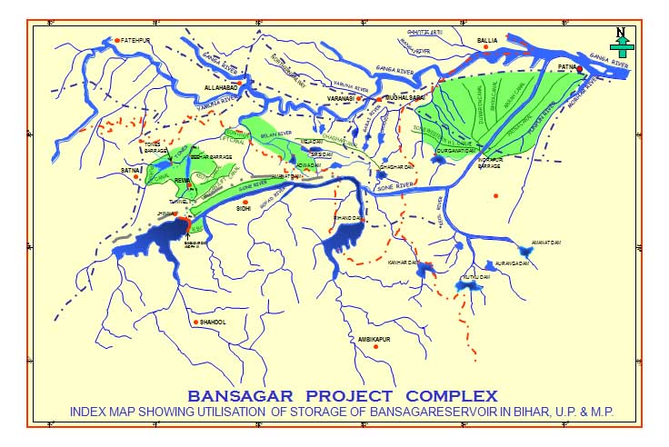
Bansagar Dam in Sone river basin in Madhya Pradesh already full, violating the rule curve, is ready to create yet another flood disaster along Sone river in Madhya Pradesh and along Sone and Ganga in Bihar.
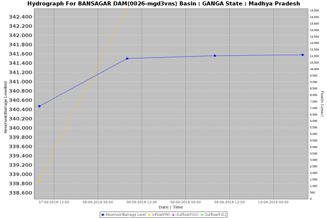
As per Madhya Pradesh Water Resources Department website’s Flood Report[i] on Sept 10, 2018 afternoon (5pm) (see the screenshots of the website below), ten gates of Bansagar dam were opened by 0.5 m at 11 am on Sept 9, 2018, releasing 35315 cusecs water. The gates were further opened to 0.75 m at 4.40 pm on same date to release 54315 cusecs. A bit curiously, the website is completely silent about any gate opening before that, it implies that no gates were opened this year before 11 am on Sept 9, 2018. The website says the water level at Bansagar Dam reached 341.63 m at 12 noon on Sept 9, 2018, level is given only at intervals of 4 hours during the day. The Dam FRL (Full Reservoir Level) is 341.64 m, so it is likely that when they opened the gates at 11 am on Sept 9, the dam may have already reached FRL. The water level at the dam has remained at 341.58 m till 8 am on Sept 10, 2018, just 4 cm below the FRL, as per the latest available information.


This information on MP WRD website is contrary to a PTI report published by FIRST POST[ii] that said, “Madhya Pradesh released 3,55,572 cusecs of water at 5.40 am Saturday (Sept 8, 2018) in Sone river, Bihar WRD PRO Arvind Kumar Singh said.”
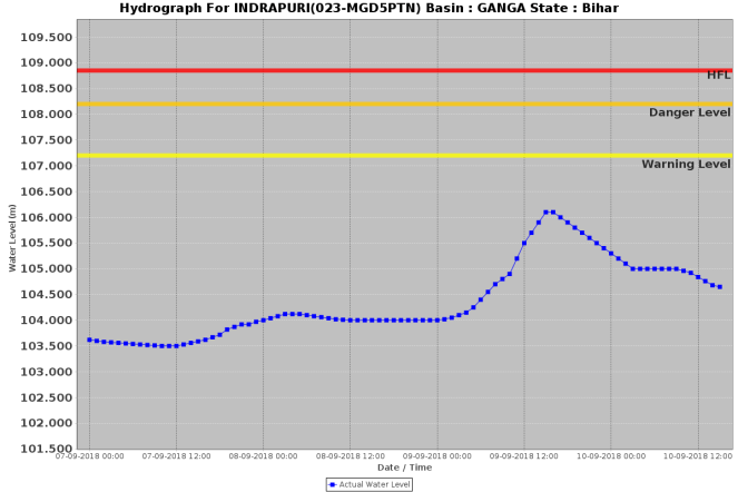
If we consider the flood hydrographs on CWC’s flood forecasting website, the gate opening seems to be closer to as reported in PTI story. Water level of Sone river at Indrapuri site, which is most upstream Level forecasting site of CWC along this river, started rising soon after midnight of Sept 8, or early hours of Sept 9, indicating that substantial quantity of water from the Bansagar dam could have been released on Sept 8, and not Sept 9, as MP WRD website claims. The water level than kept climbing till about 3-4 pm on Sept 9, falling there after, after reaching a peak of about 106.15 m. After the steep fall thereafter, the level has still remained higher than where it was on Sept 8.
The Bansagar Dam is listed as CWC’s inflow forecasting station, but its flood hydrographs does not provide most of the key information as we from the hydrograph below. We have written on twitter, tagging to CWC, but we have yet to hear from them.
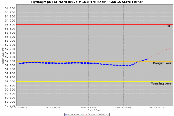
At CWC’s flood forecasting site on Sone River at Maner, which is closest to Ganga, the water level started rising only post 5 am in the morning on Sept 10, and has been steeply going up, already above the danger level of 52 m. CWC expects water level here to reach 52.65 m by 0800 on Sept 11, which is within 1.14 m of HFL of 53.79 m, incidentally reached exactly 42 years ago on Sept 10, 1976.
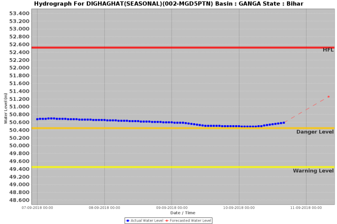
Post Sone-Ganga confluence downstream of Maner, Dighighat is the first flood forecasting site of CWC, on Ganga river. Water level here, already above danger level for several weeks now, was at 50.59 m at 1600 hours on Sept 10, with CWC forecasting it to rise steeply to reach 51.26 m by 0800 am on Sept 11, 2018. The HFL here is 1.26 m from that level at 52.52 m.
Gandhighat at Patna is the next FF site of CWC, where water level of Ganga is already at 49.43 m, above danger mark of 48.6 m for several weeks, possibly due to the Farakka’s backwater impact. Water level here is now forecast to reach 49.9 m by 0800 on Sept 11, which is within 0.62 m of the HFL, which was reached on Aug 21, 2016, thanks to Bansagar and Farakka.

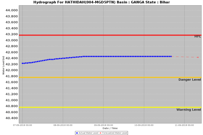
Similarly, at Hathidah, the next FF site of CWC, the water level is now steady at 42.46 m, already just 0.71 m away from the HFL of 43.17 m reached on Aug 21, 2018, again thanks to Bansagar. Considering that CWC expects water level of Ganga at Dighaghat site to go up by 67 cm, if Hathidah site were to climb that much it will be within striking distance of HFL, and considering the likelihood of continued water release from Bansagar and also the flood flows from other tributaries of Ganga, one may not be surprised if the water level at Hathidah and some other FF sites around it were to breach the HFL.
In any case, BIHAR MUST BRACE FOR THE GANGA FLOOD POSSIBLY AGAIN WITH UNPRECEDENTED WATER LEVELS AT SEVERAL SITES, A REPEAT OF TWO-YEAR-OLD EVENT THAT HAD NO CONSEQUENCES FOR THE BANSAGAR OPERATORS THAT BROUGHT THIS FLOOD TO BIHAR.
DISASTER REPEATED? In Aug 2016, Bansagar dam had played a major role[iii] in creating flood disaster along Ganga in Bihar. When flood water level at Patna Gandhighat, Hathidah and Bhagalpur had set up new High Flood Levels.
DISASTER FOREWARNED? SANDRP had earlier in early June 2018[iv] warned that Bansagar dam had water storage of 2.22 BILLION CUBIC METERS as on May 31,2018, even before the beginning of monsoon. The Weekly Reservoir Storage Bulletin of Central Water Commission as on May 31, 2018[v], said that on that date, when monsoon was yet to set in in Bansagar catchment in Madhya Pradesh, Bansagar Dam already had 43% of live storage full. Bihar officials had then told SANDRP that Madhya Pradesh was refusing to release water even when they requested and when Bihar is partner in the project. So much water in the dam even before the beginning of monsoon was clear invitation to disaster.
Could this disaster have been avoided? Yes, if:
- Bansagar Dam had started release of water much earlier rather than waiting for the dam to be full and then opening the gates.
- Bansagar dam operators had been held accountable for the flood they brought to Bihar (& Madhya Pradesh) in Aug 2016.
- If India’s dam operation policy & governance had become transparent, participatory and accountable as SANDRP has been advocated for many years. This would have included putting up updated RULE CURVE in public domain and ensuring that dam operators follow it.
- If Bansagar dam had constructed the command area canals to ensure full utilization of its water, over a decade after commissioning the dam, and it did not have massive 2.22 BILLION CUBIC METERS of water in live storage even before the monsoon.
Unfortunately, India is not learning from the blunders and disasters of the past and we are destined to keep facing repetition of them and Central Water Commission is happy to keep defending the dam operators irrespective of the consequences.
Himanshu Thakkar (ht.sandrp@gmail.com)
END NOTES:
[i] http://eims1.mpwrd.gov.in/fcmreport/control/floodreport
[ii] https://www.firstpost.com/india/flood-threat-looms-large-over-patna-after-madhya-pradesh-releases-water-from-bansagar-dam-officials-put-on-alert-5146381.html
[iii] https://sandrp.in/2016/08/23/a-tale-of-two-dams-is-bihars-unprecedented-flood-an-avoidable-man-made-disaster/
[iv] https://sandrp.in/2018/06/09/cwcs-weekly-reservoir-bulletin-closer-look-warns-of-impending-disaster/
[v] http://202.159.215.252:83/DocumentUploadRoot/DocumentId_24471/31.05.2018_CWC_Bull.pdf

One thought on “TALE OF A DISASTER FORETOLD: Bansagar Dam ready to create another flood disaster along Sone and Ganga”