Guest Blog by: : Karthik Teegalapalli (kartix@gmail.com) a researcher with the Nature Conservation Foundation
In April 2014, the Forest Advisory Committee (FAC) decided to deny clearance to the 3000 MW Dibang Multipurpose Hydro-electric Project, the largest capacity hydro project in the country proposed to be developed by the National Hydropower Power Corporation (NHPC) in the biodiversity-rich Arunachal Pradesh State (Saikia 2014). The project was also denied clearance in July 2013. More recently though, the project has been recommended forest clearance by the FAC and Environment Clearance by the Expert Appraisal Committee. Therefore it is pertinent to look at the impacts the project may have in some detail.
Ecological impacts The project, in its earlier version involved diversion of more than 5000 hectares of relatively undisturbed grassland and tropical forest habitat. These and the adjoining forests harbour endangered species such as tiger, leopard, serow as well as the critically endangered takin, all of which are protected under Schedule I of the Wildlife (Protection) Act, 1972 (these species are also listed as present in the area in the Environmental Impact Assessment report of the project, undertaken by National Productivity Council, Guwahati). The grasslands in the area harbour the critically endangered Bengal Florican, a grassland habitat specialist (Sinha et al. 2014). Other species recorded from the area include the critically endangered white-rumped vulture, the slender-billed vulture and the white-winged wood duck. The project site lies in an area identified by the Bombay Natural History Society as a Ramsar site and an Important Bird Area (Islam & Rahmani 2004). The habitat of six endangered plants (Aconitum ferox, Coelogyne mossiae, Dendrobium aurantiacum, Paphiopedilum fairieanum, Paphiopedilum venustum and Vanda coerulea) will be submerged by the reservoir (Chernaik 2007).
The project will also affect aquatic species; the dam will block the breeding migration of four species of fish: the Vulnerable snow trout Schizothorax richardsonii, Endangered golden mahseer Tor putitora, Near-Threatened mahseer Tor tor, and chaguni Chagunius chagunio. The recommendation of the Environmental Management Plan of the Project to establish fish hatcheries for these species is impractical and can have further damaging effects on the species due to collection of eggs and spawn from the wild population.
The project will have other collateral damages such as through Compensatory Afforestation (CA) that often involves converting an area with diverse native species into monocultures, as has been shown for other dams such as the Sardar Sarovar Dam on the Narmada river (Bhatnagar 2004). The project involves CA of a relatively large area of over 100 sq. km (double the area of forest being affected by the project). The ill-effects of this conversion particularly for the project can be expected to be higher if tree-less natural grassland habitats in Dibang Forest Division, Namsai Forest Division and Anini Social Forestry that harbour grassland habitat specialists are planted with undesired native or non-native tree species. Perhaps the irreversible loss of biodiversity in the forests and grasslands that will be diverted for the project could never be ‘compensated’.
During the construction phase of the project, an estimated 32 lakh truckloads of boulders and 16 lakh truckloads of sand is to be extracted from the Dibang river basin. Unsustainable extraction of sand and boulders has significant negative effects on geomorphology, bank stability, flood character of the river, water quality, river flow, and the biodiversity in the river basin (Padmalal et al. 2008). The project during the construction is to generate 198 lakh cubic meters of muck which will be disposed in the river bank which will cause further loss of 120 ha of river habitat. Construction of new roads (64 km) and widening of existing roads (19.5 km) will also lead to removal of trees and increase the vulnerability of the region to landslides and erosion (Chernaik 2007).
Social impacts The Lower Dibang valley is currently a region of relatively low human population density (~14/km2); the entire population of the Idu-Mishmi tribe is about 12,000. The influx of approximately 6,000 project staff (which is very likely an underestimate) for a period of 8 years or more will affect their way of life, their culture and their tradition as well as open up access to relatively moderately disturbed habitat and biodiversity in the region.
Downstream effects include those on fisheries, agricultural lands and wetlands (beels) and the dam will also increase the vulnerability of the region to flash floods. For instance, in the year 2007, flash floods caused due to sudden release of water from the relatively smaller 405 MW Ranganadi project in the Lower Subansiri district in Arunachal Pradesh swamped 83 villages and caused huge loss of lives and property in the Assam State. The project will have a considerable impact on the Dibru-Saikhowa National Park in Assam which has not been studied in detail in the EIA.
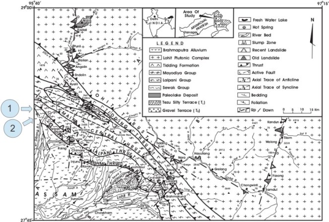
On shaky grounds A critical issue with the project is that the site lies close to an active Fault Line in the Mishmi Thrust of the Mayudia Group in Eastern Arunachal Pradesh with a history of several seismic activities including the Great Assam earthquake of 8.6 magnitude in 1950 (Figure 1, Misra 2009). In the event of an earthquake, the project poses a risk of catastrophic submergence of several villages and vast areas of forests downstream. The recommendations of the Environmental Impact Assessment (EIA) report of the project are cursory and suggest further research on the natural seismicity of the region as well as reservoir-induced seismicity, which should be the basis for the decision about the project.
Notwithstanding these, in Oct 2014 the project was cleared by the FAC constituted by the new Government, although the committee still had four of the six members who had earlier twice recommended rejection of clearance. Is this decision driven by changes made by NHPC in their project plan? Clearly not. Diversion of forests has now been reduced by a mere 9% to about 4600 hectares; instead of 3.55 lakh trees, the felling has been reduced to 3.24 lakh trees, the power generation capacity has been reduced by 2.3% and the height of the proposed dam reduced by 10 m. In fact, the FAC rejection of April 2014 was for this 10 m rejection proposal!

NHPC misleadingly and baselessly claimed that they ‘were not in a position to reduce the height of the dam any further, as it would significantly affect the power generation’. The decision to provide clearance to the project seems like a hasty one driven by the blinders of development and the consequences of such projects is evident from the fate of the Lower Subansiri Hydropower Project in the same State, also by NHPC. After 12 years since the LSHP was initiated and after an expenditure of over Rs. 5000 crores, the work has been on a standstill for the last 35 months as a result of India’s biggest anti-dam people’s movement (Dandekar & Thakkar 2014). Considering the economic, ecological, environmental and social costs of the project as well as the geophysical risk it poses, it would be prudent to withdraw the project till a credible, detailed cumulative study covering these aspects is undertaken in a transparent and participatory way. While the rest of the world is recognising the ill-effects of dams, with the largest dam removal project on the Elwha river in the United States completed just three months back, it is paradoxical that we are heading in the other direction; of building the highest dam in the country and largest capacity reservoir of the North East India without even basic studies, credible impact assessment and democratic decision making process.
References:
Bhatnagar, D. (2004) Uprooting Forests, Planting Trees: Success of Compensatory Afforestation Measures Mitigating the Deforestation for the Sardar Sarovar Dam, India. University of California at Berkeley.
Chernaik, M. (2007) Evaluation of the Environmental Impact Assessment Report & Environmental Management Plan for the Dibang Multipurpose Project (3000 MW) https://www.elaw.org/system/files/Evaluation+of+the+EIA+report+for+the+proposed+Dibang+dam.doc
Dandekar, P. & Thakkar, H. (2014). Manipulating Environment & Forest Clearances for Dibang Project: Déjà vu: LSHP History repeated: Will it be tragedy or comedy https://sandrp.wordpress.com/2014/10/06/manipulating-environment-forest-clearances-for-dibang-project-deja-vu-lshp-history-repeated-will-it-be-tragedy-or-comedy/
Islam, M. Z. & Rahmani, A. R. (2004) Important bird areas in India: priority sites for conservation. Indian Bird Conservation Network, Bombay Natural History Society and BirdLife International (UK).
Misra, D. K. (2009) Litho-tectonic sequence and their regional correlation along the Lohit and Dibang Valleys, Eastern Arunachal Pradesh. Journal of the Geological Society of India, 73: 213-219.
Padmalal, D., Maya, K., Sreebha, S. & Sreeja, R. (2008) Environmental effects of river sand mining: a case from the river catchments of Vembanad lake, Southwest coast of India. Environmental Geology, 54(4): 879-889.
Saikia, P. J. (2014). Six years after PM laying the foundation ston: No clearance, no work for 3000 MW Dibang Dam.
Sinha, A., Hoque, J., Pradhan, T., Bakshi, M. K., Pulu, J., Singh, A. K. & Ahmed, F. (2012) Sighting record of Bengal Florican Houbaropsis bengalensis (Gmelin, 1789) (Aves: Gruiformes: Otididae) in Lower Dibang Valley District, Arunachal Pradesh, India. Journal of Threatened Taxa, 4(14): 3375-3376.

Reblogged this on By the way ! and commented:
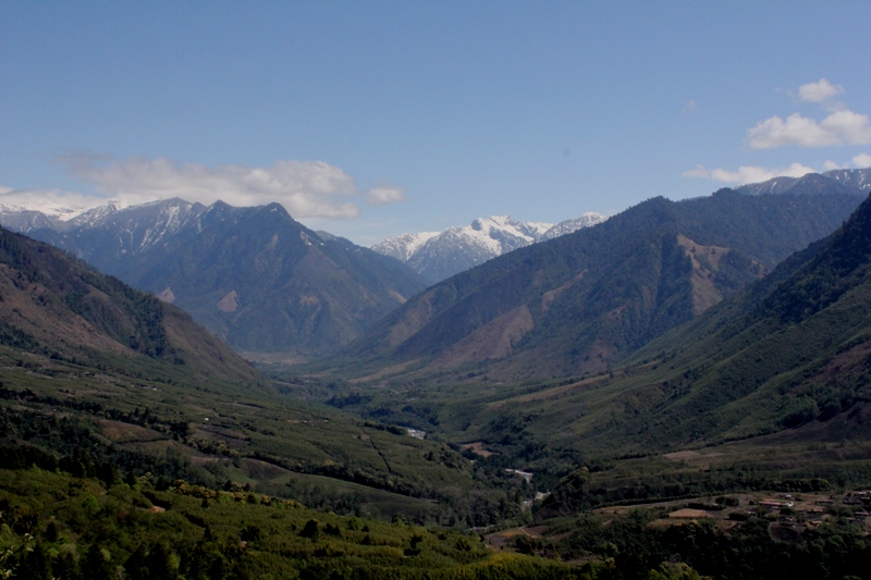
The tallest dam in India to be built on a seismic fault line, with the largest capacity reservoir submerging rare wildlife habitat
LikeLike