“A river is an ecological system that flows and performs many functions” says Ramaswamy R Iyer, former Secretary to the Government of India, at the India Rivers Week 2014
Over 125 river experts, planners, researchers, artists, enthusiasts and activists from different parts of the country that have congregated at first ever India Rivers Week being held in Delhi, discussed and debated on how to define a river. Ramaswamy R Iyer, former Secretary to the Government of India, defined the river as “A natural organic hydrological ecological system that flows & performs many functions.” The attempt was to pen an aspirational, visionary and implementable definition of rivers to underpin an India Rivers Charter”, to be prepared at the end of these deliberations.
Manoj Misra of PEACE Institute, New Delhi, speaking at the India Rivers Week-2014, said the working group he convened defined river as a, “Hydrological, ecological, geomorphic living entity containing other life forms, landscape level ecosystem in dynamic equilibrium between rainwater, snow, glaciers surface water, groundwater, sea, estuary and providing a large number of social, cultural, ecological and economic services to people and ecosystems all along its basins.”
The event is being organized between 24-27 November, 2014 by a consortium of NGOs including WWF India, INTACH, SANDRP, Toxics Link and PEACE Institute Charitable Trust, with additional support from Arghyam (Bengaluru), International Rivers (Mumbai), and Peoples Science Institute (Dehradun) to discuss, deliberate and exchange their experiences and ideas aimed at the conserving, rejuvenation, restoration of rivers in the country.
Can we think in terms of ‘rights of the river’ and then make it part of some legal system, questioned different groups. The groups were discussing the rivers right to unfettered flow, space for flood plains, flood, breathe, perform ecosystem functions, lateral connectivity and natural water.
Manu Bhatnagar, INTACH, representing the deliberations of another group said, “River is a living commons that drains a catchment along a natural course with natural and dynamic flow and providing ecological goods and services necessary for the development and sustenance of human civilizations under challenging social, economic, political and climatic drivers.” Speaking on the issue Professor Brij Gopal noted that, “River regulation is the root of all problems. We need to regulate human activities”.
“We are not obliging the rivers by editing her flow, we in fact are obliged by the rivers due to their life-giving flows”, said Mallika Bhanot, representing another group.
The conference also deliberated on what a river is not. Manshi Aasher said that a river is not static, an artificial drain, lifeless, embanked/ obstructed, without sand and sediments, carrier of wastewater or just a channel of water.
A living, wide, water course which has natural fresh, flow of water above and under the surface, in its course, nurturing life forms, ecosystems, culture, conserving biodiversity in it and is inclusive of small and big tributaries in its catchment area.
Shashank Shekhar explaining about river flows, clarified, “The flow with its natural variability includes natural water, nutrients, sediments and biota and is the defining characteristic of river systems.” Dinesh Mishra, Barh Mukti Abhiyan, said, “Rivers are self cleansing, flooding is purifying and rivers become pure after floods.” Pranab Choudhary discussed the issue of conservation of biodiversity as against utility and noted the importance of defining and protecting rights of riparian communities especially the poor, including from downstream areas, today these are neither assessed, nor compensated.
Paritosh Tyagi summed up the discussion by saying that the older concept of River Action Plan that focused on river flow should be replaced with focus on the complete basin.
2015 Rivers Calendar The organizers have brought out the 2015 desk calendar featuring the photos of 12 different rivers and highlighting the sacrifice tribals have made during the famous struggle against the Koel Karo project in Jharkhand.
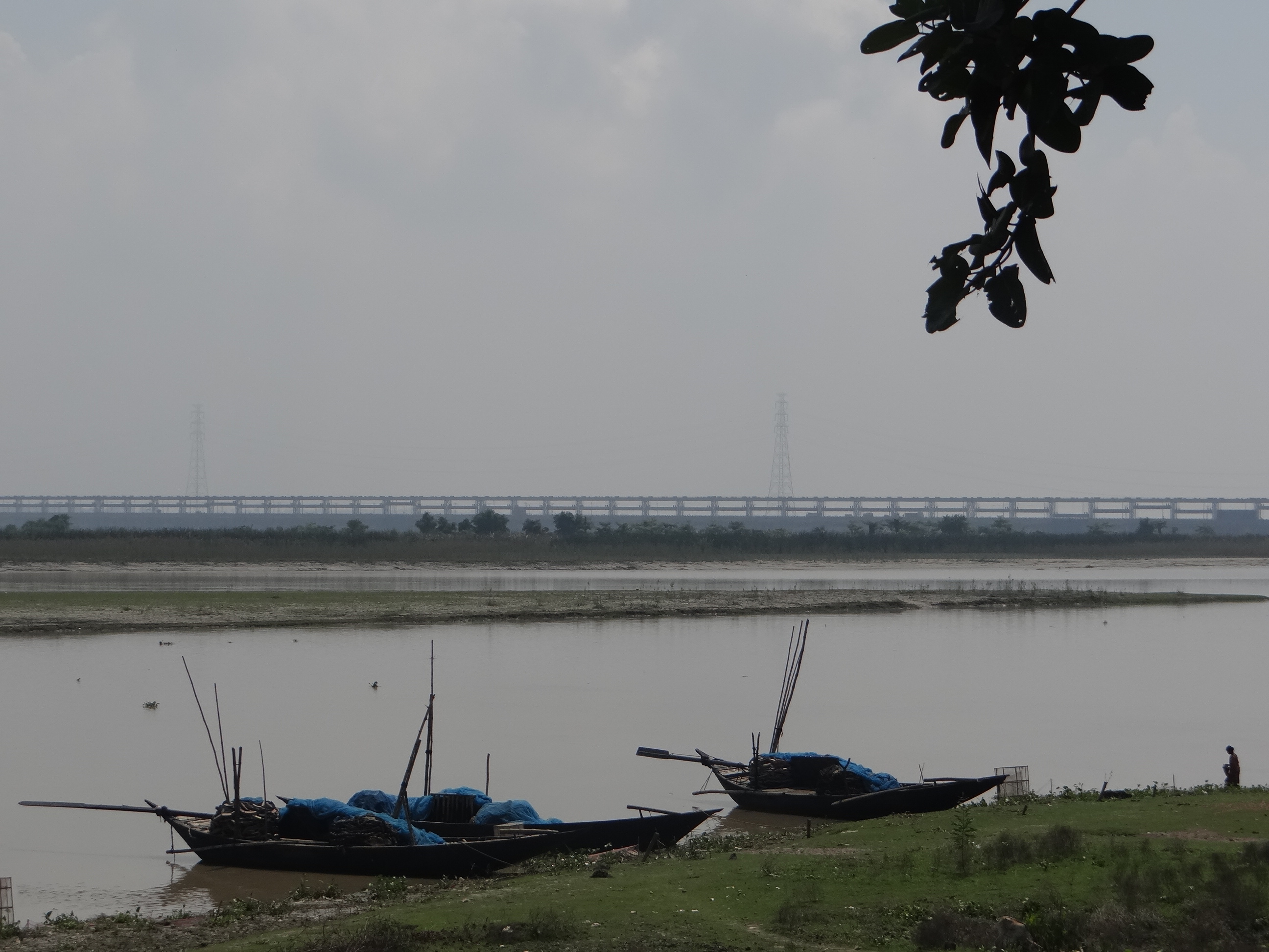
“When Farakka barrage was built, the engineers did not plan for such massive silt. But it has become one of the biggest problems of the barrage now” said Dr. P.K. Parua[1]. And he should know as he has been associated with the barrage for nearly 38 years and retired as the General Manager of Farakka Barrage Project (FBP). I remembered the vast island of silt in the middle of the river barely a kilometer upstream of the Barrage and the people who told us their homes were devastated by the swinging river.
Silt Islands just upstream the Barrage. Photo: Parineeta Dandekar, SANDRP
Though called a barrage, Farakka Barrage is a large dam as per ICOLD, WCD and CWC definitions, with associated large dimensions and impacts. To call it a Barrage is misleading.
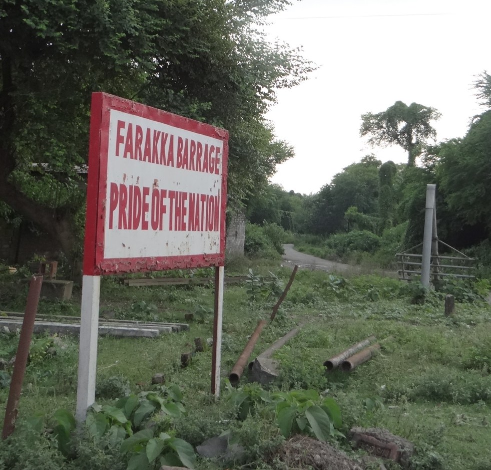
Commissioned in 1975[i] across Ganga in Murshidabad District of West Bengal and just 16 kms upstream of the Bangladesh Border, Farakka Barrage has been mired in controversies from the very beginning. Its role is singular: to transfer 40,000 cusecs water from Ganga to its distributary Bhagirathi-Hooghly (hence forth referred as Hooghly). And to make Hoogly river navigable from Kolkata port upstream till Farakka barrage. It was thought that this water will push the silt that is eating up the Kolkata Port and will protect the Port for navigation and economy. In reality, Kolkata Port continues to decay and the barrage has had such severe and unforeseen impacts on the people of India and Bangladesh that the call to review Farakka Barrage entirely is getting louder by the day.
A lot has been written about Farakka Barrage by Indian (and many times by Bangladeshi) authors, so why are we discussing Farakka again? Because Political leaders like Shri. Nitin Gadkari have stated that there are plans of building a barrage after every 100 kms in Ganga from Haldia to Allahabad, a 1600 kms stretch. So we are looking at possibly 15 more barrages on Ganga. But before taking decision about building any other such structure, we need to understand the range of impacts a single barrage has had on the lives of millions of people and how inadequate has been our response in addressing these impacts. Farakka holds critical lessons for Indian politicians, policy-makers, international groups and financial institutions like World Bank dreaming of making a string of barrages across a river which has one of the highest silt loads, densest population and the largest deltas in the world.
Ganga as a “Waterway” Government of India is planning to aggressively develop 1620 kilometers of National River Ganga as “National Waterway 1” (NW1). There is a profound difference between a Highway and Waterway. A highway is simply a road while NW1 is actually River Ganga, performing several other functions, it is important to recognise how the NW1 would affect these functions and the river itself. NW 1 spans from Haldia, near the mouth of Ganga Estuary in West Bengal, to Allahabad in Uttar Pradesh, passing through four states and cities of Haldia, Howrah, Kolkata, Bhagalpur, Buxar, Patna, Ghazipur, Varanasi and Allahabad.
The Inland Waterways Authority of India (IWAI)[ii] plans to use this waterway for the transport of “coal, fly-ash, food grains, cement, stone chips, oil and over dimensional cargo.” Not surprisingly, companies keenly interested in using this waterway include “thermal power plants, cement companies, fertilizer companies, oil companies” etc. In order to make this stretch navigable, IWAI plans initiatives like “river training and conservancy, structural improvement, dredging, and Construction of terminals at Allahabad, Varansai, Gazipur in Uttar Pradesh, Sahibganj in Bihar and Katwa in West Bengal.”
Although this plan was on paper for some years, the new government has approached the World Bank for support of nearly Rs 4200 Crores (700 million dollar) for its implementation. In July 2014, the World Bank agreed to fund initial 50 million dollars including technical support (thus creating work for its own experts!). World Bank Team has already visited Patna for this project and joint meeting of IWAI and World Bank has taken place at Varanasi[iii]. No public consultation has been held thus far.
Although River Navigation has nothing to do with River Rejuvenation, Shri. Nitin Gadkari, Union Surface Transport & Shipping Minister with additional portfolio of Rural Development, who played an active role in the Ganga Manthan, announced this navigation plan as a part of ‘Ganga Rejuvenation’.[iv]
He also announced that the plan entails erecting barrages (dams) on the Ganga at every 100 kilometer interval from Haldia to Allahabad. This would mean damming the Ganga rough about 15-16 times, to maintain water levels and navigability.[v]
If the plan moves ahead, it may escape environmental clearance as the very limited EIA Notification 2006, being actively amended for dilution by the Modi government, includes only irrigation and hydropower dams in its ambit. This does not mean that these barrages will not have severe impacts on the river, its people and its ecosystems. Far from it. SANDRP has written about the impacts of Upper Ganga Barrage at Bhimgouda, the Lower Ganga Barrage at Narora and the Farakka Barrage in Murshidabad, West Bengal (SANDRP’s Report on Farakka, 1999: https://sandrp.in/dams/impct_frka_wcd.pdf).
The analysis at hand is based on official documents and research, site visit, interviews and discussions with experts and local people.
Farakka Barrage, in the backdrop of proposed Barrages
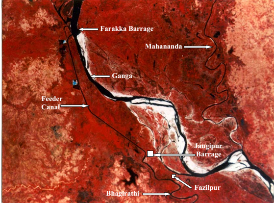
Farakka Barrage, 2.62 kms long, commissioned in 1975 has a unique purpose. The barrage was built for diverting waters of Ganga into its distributary The Hooghly/ Bhagirtahi, for flushing sediments and maintaining the navigability of Kolkata Port (& Hooghly River) which lies at the mouth of Hooghly. Records about high sedimentation in Hooghly can be traced back to 17th Century, but is known to increase following building of Damodar Dams in post independent India. Construction of a barrage on Ganga and diverting its waters into Hooghly was suggested in the 19th Century by Sir Arthur Cotton. After independence, the historic Kolkata port was becoming hugely silted due to sluggish freshwater from upstream on the one hand and and strong saline intrusion from the sea on the other. At that time, Farakka Barrage was thought to be an answer to these problems.
The Farakka Barrage. Photo: Author
Even then, some lone voices highlighted the possible impacts of Farakka Barrage. Notably Mr. Kapil Bhattacharya, Engineer-in-Chief of West Bengal had warned about absence of sufficient water, catastrophic floods and sedimentation in the upstream back in 70s. When Pakistan (current Bangladesh was part of Pakistan during 1947-1971) upheld his views, he was branded as a traitor and lost his job. He had highlighted that one of the main reasons why Hooghly was desiccating was Damodar Valley Corporation (DVC) dams on Damodar and Roopnarayan Rivers.
The Farakka Barrage completed in 1975 has 109 gates, and a feeder canal of 38.1 kms emanating from the right bank, carrying water from Ganga to Hooghly. There is one more barrage at Jangipur in the downstream and afflux bunds in the upstream of Farakka, diverting waters of all smaller rivers like Pagla and Choto Bhagirathi into Farakka, effectively drying them in the downstream.
The Feeder canal is supposed to divert 40,000 cusecs water continuously from Ganga into Bhagirathi/ Hooghly. Hooghly-Bhagirathi itself is not a small river. It is a system drained by 7 tributaries like Pagla, Bansloi, Mayurakshi, Ajoy, Damodar, Rupnarayan, Haldi and the two offshoots of Ganga – Jalangi and Churni.
Location of Farakka Barrage Depiction From : Rudra, Encroaching Ganga and Social Conflicts
Impacts and performance of Farakka Barrage
Several grave questions are being posed on the utility of the barrage itself and its impacts. Some of the main points are illustrated below:
Hooghly estuary cannot be made silt-free by 40,000 cusecs from Farakka only
River Expert Dr. Kalyan Rudra, an authority on rivers in Bengal, especially their interactions with sediment, says that the initial objective of Farakka of flushing silt from the mouth of Hooghly has been “frustrated”[vi]. This assessment has been supported by many, including the past Superintending Engineer of Farakka Dr. P.K. Parua (Pers. Comm.) According to Kolkata Port Trust, the dredging of silt at Kolkata Port has been rising from 6.40 million cubic meters (MCM) annually from Pre-Farakka days to four time increase at 21.88 MCM annually during 1999-2003.
The answer, according to Dr. Rudra, lies in the fact that freshwater flow brought by the Hooghly Estuary, even with 40,000 cusecs from Farakka is just too meagre to flush sediments deep down the estuary. The difference between volumes of freshwater brought by Hooghly, as against the tide bringing saline water from south to north is as much as 1:78, making any deep flushing due to freshwater nearly impossible. Dams in the Hooghly Bhagirathi Basin by Damodar Valley Corporation have further arrested freshwater which could have naturally replenished Hooghly estuary. At the same time the stated aims of Damodar Valley Corporation, fashioned on the lines of Tennessee Valley Authority have not been fulfilled.
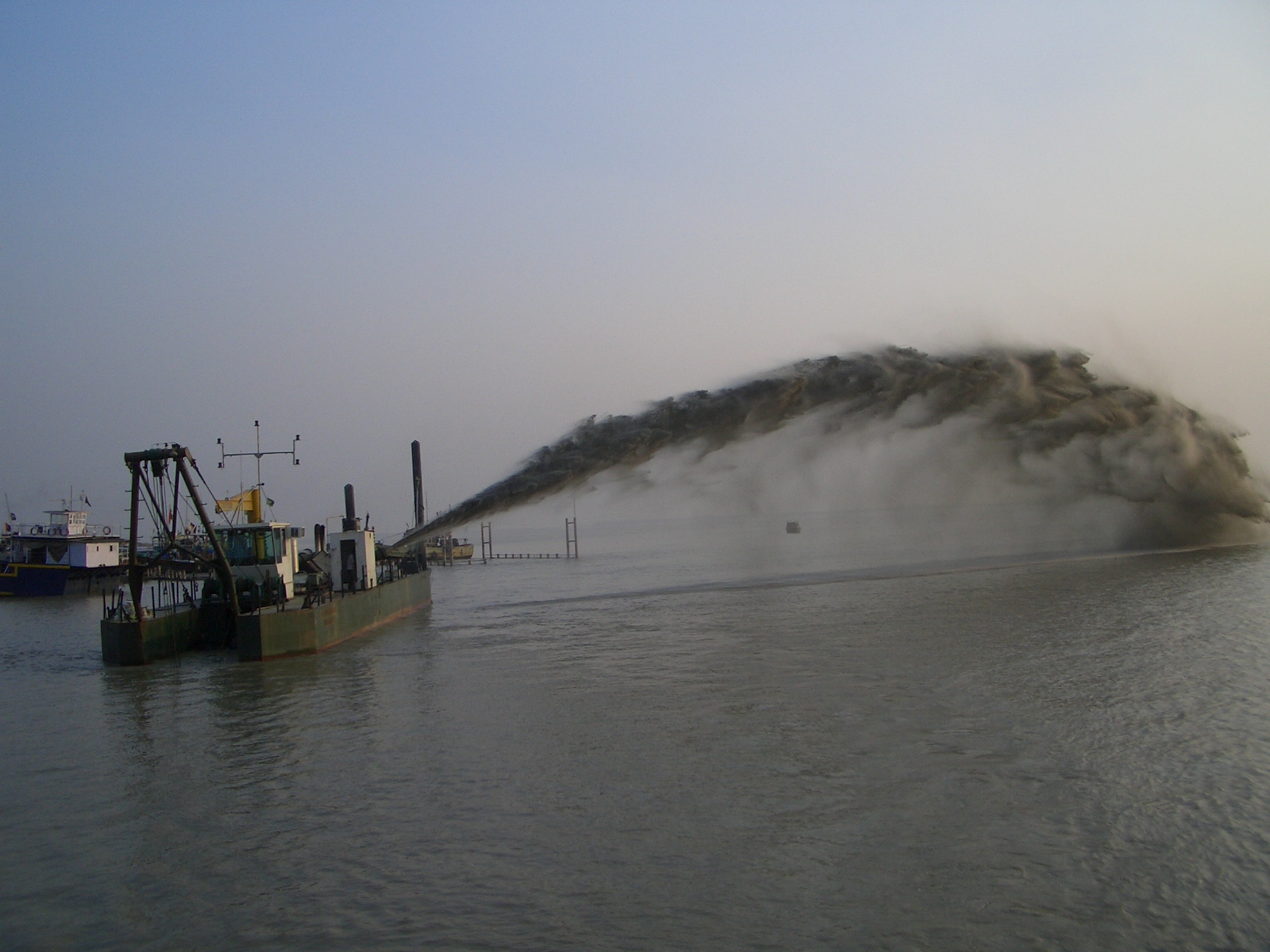
Currently, the functioning of Kolkata Port and Haldia port is entirely at the mercy of Dredging Corporation of India (DCI) to desilt the river to maintain sufficient draft (allowable depth of a ship’s keel under water). DCI gets about Rs 300-350 Crores per year for dredging the channel, although several problems have been unearthed like dumping the excavated silt back in the estuary from where it is washed back in the channel. In 2009, the Government of India had actually written to the Kolkata Port Trust, saying that it has become a “liability” and it should explain why it should continue to receive dredging subsidies. A PIL has been filed[vii] in 2013 in Kolkata High Court to save Kolkata and Haldia ports by intensive dredging.
Dredging the National Waterway I Photo: WRIS
It is clear that 40,000 cusecs water from Farakka is not able to help the Kolkata Port much as was envisaged earlier. SANDRP tried to talk with officials at the Kolkata Port Trust, but they declined answering any questions saying that Farakka is a bilateral issue.
This has led to a situation where we have the barrage and the impacts of two countries and millions of people, without even achieving objective for which the project was developed.
2. Sedimentation in the upstream of Farakka Barrage and its massive implications for India and Bangladesh
It is estimated that Ganga carries a silt load of 736 Million Tonnes (MT) annually, out of which about 328 MT of sediment gets deposited in the upstream of Farakka Barrage ANNUALLY[viii]. This annual addition of enormous sediment in the upstream of the barrage has made the river extremely shallow and any ship transport past Farakka has become nearly impossible. As we saw during our visit, islands/chars have formed barely a kilometer upstream the barrage, where animals graze, making any transport nearly impossible.
This massive retention of sediments has resulted in a two-pronged problem:
3. Contribution to delta subsidence and rising sea level in Bangladesh and India
Water released below Farakka barrage has significantly less silt load as about 328 MT silt gets deposited at Farakka. This water has a higher eroding capacity and erodes downstream riverbed. But there is an additional problem: World Heritage site of Sunderbans at the mouth of the Ganga-Brahmaputra-Meghna delta, shared between India and Bangladesh is witnessing possibly the first and highest numbers of Climate Change refugees in the world due to Ingressing Sea which is eating away at smaller islands and the delta. Part reason for this delta subsidence is sea level rise due to global warming and related changes, but the driving reason for encroaching seas is not only sea level rise, but the sinking river delta due to trapping sediment in the upstream dams and barrages like Farakka. The role of river sediments in building deltas is crucial. Ganga-Brahmaputra-Meghana Delta is subsiding rapidly and is categorized as a ‘Delta in Peril’ by experts like Syvitski et al, due to reduction in sediments reaching the delta and compaction of delta, furthering sea level rise. According to recent studies, the rate of relative sea level rise per year in the Ganga Brahmaputra delta is in the range of 8-18 mm per year, one the highest in the world. The related sediment reduction has been a whopping 30% in the twentieth century. (SANDRPs report on Delta Subsidence and Effective Sea Level Rise due to sediment trapping by dams: https://sandrp.wordpress.com/2014/05/07/sinking-and-shrinking-deltas-major-role-of-dams-in-abetting-delta-subsidence-and-effective-sea-level-rise/)
Farakka Barrage has been highlighted as one of the causes for this blocking of sediments at an important juncture. Any role played by Farakka in delta subsidence of GBM Delta has a massive impact on millions of people residing in this delta. According to Prof. Md. Khallequzamman (Pers Comm.), the amount of sediment influx flowing into Bangladesh from upper reaches in India has dropped from 2 billion tons per year in the 1960s to less than 1 billion tons per year in recent years, which is not enough to keep pace with rising sea.[ix]
4. Erosion in the Upstream of the barrage due to Sedimentation
Farakka Barrage is getting silted up due to millions of tonnes of sediment being deposited in the upstream annually. Ganga has been a meandering river, changing courses over centuries, forming paleo channel and ox bows. This deposition of sediment in the upstream is accelerating swinging of Ganga alarmingly to the left bank of the river. This is leading to tremendous erosion in Malda and surrounding regions. More than 4000 hectares of land in Malda has been eroded by the Ganga since 1970s. The river has also breached 8 embankments. Although a number of authors have conclusively written about this and even Legislative Assembly of West Bengal has been unequivocal in saying that “It is accepted all levels that the construction of Farakka Barrage is solely responsible behind the erosion of river Ganges in Malda district”, Central Water Commission trivializes this fact and does not accept any responsibility of Farakka.The only issue CWC seems to be bothered about is the health of the barrage itself which is compromised by erosion on the left bank. In official correspondences of CWC and MoWR scrutinized by SANDRP, the agencies do not mention anything about plight of thousands of people, who are refugees of a swinging river, but are only concerned about the strength of the barrage.[x]
According to Audit Report on Farakka Barrage by Indian Audit and Accounts Departments, between 2006-2012, the “Unintended Consequences” of Farakka include:
Induced water through feeder canal raised water level of Bhagirathi by about 5 meters near Jangipur and does not allow Bansloi and Pagla to join Bhagirtahi freely. A new wetland due to congestion formed Ahiron Beel which has submerged fertile land.
The barrage has trapped substantial sediment and hence river in changing course. In homogenous situation the oscillation of river is secular but it gets aggravated due to Farakka Barrage. On account of Rajmahal hills on right bank and Farakka barrage on the channel, the river erodes the left bank.
The 10 day cycle of increased and decreased release of water from the Barrage has resulted in a complex phenomenon of recharging ground water by river and then receiving base flow from groundwater ( when river is low). The frequent change in water level on account of 10 day altered flow adversely affects the rivers hydro geomorphology leading to escalating bank erosion.
River bed height in Farakka pondage has increased and the river is compensating this reduction by expanding its cross section sideways
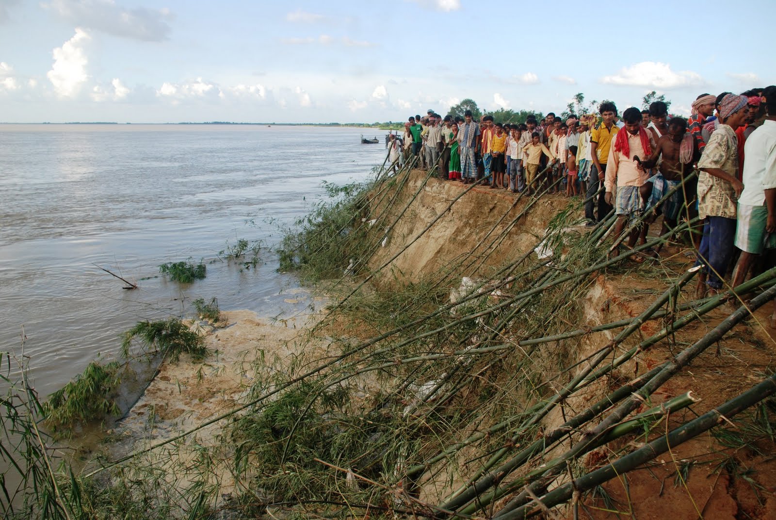
Bank Erosion and Embakment breach at Hiranandpur Phot with thanks: Soumya Desarkar
5. Erosion Downstream of the barrage, leading to loss of life and property:
Sedimentation upstream the barrage, coupled with natural swing of Ganga has meant that the river is swinging to the left, encroaching the left bank, leading to erosion in thousands of villages, roads, fields in the downstream of the Barrage in India as well as Bangladesh, causing annual floods. The Irrigation Department West Bengal (Report of the Irrigation Dept for 1997-2001) itself has agreed not only about this erosion due to Farakka Barrage, but has also cautioned about the possibility of outflanking of the Farakka Barrage itself. Many experts maintain the eminent possibility of Ganga outflanking the barrage to flow through its old course of the 15th century, which will reduce the barrage to just a bridge.
On our visit to Farakka, Kedarnath Mandal, a veteran activist working on issued of Ganga and Farakka accompanied us to see extensive erosion in the left bank of the river in the upstream at Simultola as well as downstream in ChaukBahadurpur. In both these regions, the eroding river has paid little heed to the erosion control measures on the banks. Huge boulders have been swept with the current, destabilizing land in their wake.
Washing away erosion control measures at Chow Bahadurpur downstream FBP Photo: Author
We saw extensive bank erosion in the left bank on the downstream where all measures like bull headed spurs, dip trees, porcupines, gunny bags, geo-synthetic covers, boulders bars, boulder crates with nets, etc. have been eroded.
In all this din, the people residing in the chars, their leaders like Kedarnath Mandal, River experts and even the Legislative Council of West Bengal maintain that though erosion and changing courses is a character of Ganga, it has worsened and accelerated hugely since Farakka Barrage. In fact the 13th Legislative Assembly Committee (2004) in its 7th Report notes “It is accepted at all levels that the construction of Farakka Barrage is solely responsible behind the erosion of river Ganges in Malda district”.
6. Near Impossibility of desilting Farakka Barrage
To say that the challenge of desilting Farakka Barrage is Herculean, will be an understatement. The irreversible circle of events is highlighted by the fact that in order to have any appreciable impact, the amount of sediment lifted from the barrage should be at least twice the amount deposited per year, if the project is to be completed even in thirty years. But that seems impossible. According to Dr. Rudra, “Doing so will require a fourteen lane dedicated highway from Malda to Gangasagar” and the transport cost alone “would be nearly twice the revenue earned by Government of India in a year.” Dr. P.K. Parua also accepts that desilting the barrage will be next to impossible.
Such is the scale of sedimentation at Farakka.
7. Source of conflict with Bangladesh
Experts and authorities from Bangladesh have been raising the issue of impact of Farakka for several years now. Farakka Barrage not only obstructs the flow of sediments in Bangladesh, but also diverts waters of Ganga away from Bangladesh delta, depriving millions of fisherfolk and farmers from their livelihood. Water sharing from Farakka, particularly in lean season is now governed by Ganges Water Treaty of 1996. The Treaty holds force between 1 January to 31st May each year and water sharing calculations are based on 10 day flows. Some experts from Bangladesh have maintained that Ganges Water Treaty is not being implemented properly and Bangladesh is receiving less water than its due.[xi] There are issues raised by the Indian side as well of dwindling water availability. All in all, the barrage and the resultant Treaty continues to be a source of impacts for the river and people of the two nations.
Meeting officials at Farakka Barrage
SANDRP met with the Authorities at the Farakka Barrage Project office, which is under the Ministry of Water Resources (MoWR), at New Farakka. After meeting the officials, it was clear that they have no program for silt management at all. They do not even see this as an area of concern and are only concerned with anti-erosion works, which are failing miserably, and releasing water to Kolkata Port, which is not improving its navigability.
While some may argue, rather irrelevantly (considering the warnings of Kapil Bhattacharyya), that Engineers in 1950s, 60s and 70s were not equipped or aware of the issues related to sediment and its far-reaching impacts like erosion, deposition, floods, even sea level rise, the same in any case cannot be said about the current water management. They have the privilege of better knowledge, better resources and also lessons from past experiences. But despite having clear evidence that silt of Ganga is playing havoc with millions in India as well as Bangladesh, the Farakka Barrage Authorities tell us that they have no plan for silt management the barrage except annual erosion control measures.
The mandate of the barrage authorities is also 120 kms of bank erosion works, 40kms in the upstream and 80kms in the downstream. We were told on the condition of anonymity that this extensive work leaves little time even for maintaining the barrage. The bank protection work is also not permanent and is eroded with flood waves. The bureaucratic set up at Farakka makes it impossible to take proactive decisions about Barrage maintenance. The gates of the barrage need replacement, but there is hardly any agency interested in working for Farakka Barrage due to bureaucratic delays.
The officials told SANDRP that the only desilting measure that can be adopted is opening all gates of the Barrage, but that will not be possible unless all gates are replaced as many gates are faulty. Replacing all gates of Farakka will take at least two more years and we do not know even after that whether silt can be flushed. Such a flushing will need a major flood event and the impact of such sudden flushing of billions of tonnes of silt in the downstream will be unprecedented & huge.
Meeting with Farakka Barrage Authorities leaves one with more questions than answers.
Interview with past official of Farakka
SANDRP discussed the multiple issues of Farakka with one of the senior retired official from the Farakka Barrage Authority who has seen the work of the FBPA closely over several years. Some excerpts from these discussions.
SANDRP: Sir, do you think Farakka is fulfilling its functions?
Answer: Farakka was not only designed for diverting water for Hooghly, it was foreseen that there may be an Irrigation component and even a hydropower component. But the inflow at the barrage was over calculated. We never had that sort of inflow in the project. Add to this Treaty with Bangladesh in 1996 and India was left with little water. I would say objectives of Farakka were only partially fulfilled. The barrage has a designed discharge of 27,00,000 cusecs and we have been able to achieve that discharge only twice since commissioning the barrage. In the recent years, water flow has been declining sharply at the barrage. This further handicaps all its functions.
SANDRP: There are several problems associated with silt deposited in the upstream of the barrage like floods, change in course of the river, erosion, etc. Is there any way to tackle this deposited silt?
Answer: Yes, that is a serious problem. This is being faced by ports and barrages the world over and also across India. There are so many players responsible for the increasing silt load and reduced water in the river, right from Nepal.
We can say that the scale of the sediment issue was not understood when the barrage was designed, the engineers then did not have the knowledge or tools for this. Even now, there is no easy way this issue can be tackled. Desilting the barrage would be very costly, and what would be do with the collected silt? Malda and Murshidabad region is densely populated, we cannot dump it anywhere. If we dump it in the river, there will be other problems. It is possibly an evil we have to live with now.
SANDRP: There are plans to erect about 16 more such barrages on the Ganga main stem. What would be the lessons from Farakka for these barrages?
Answer:I think this is a horrible plan. In addition to the challenge of silt, I wonder where will the water come from? Supplies from Upper Ganga Canals are increasing, reducing water flow in the river. Uttar Pradesh is increasing the capacity of Lower Ganga Canals. More and more abstraction will happen. Such a plan does not seem feasible and will be harmful for the river as well.
Ecological Impacts
There’s no Hilsa here
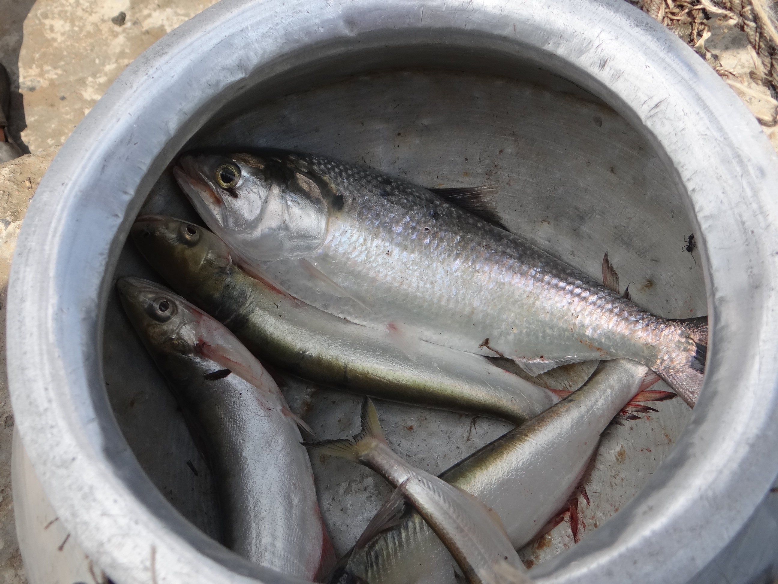
Farakka Barrage has stopped migration of economically important species like the Hilsa (Tenualosa ilsha) and Macrobrachium prawns, both Ilish (Hilsa) and Chingri (Macrobrachium) hold a special significance to people in West Bengal and Bangladesh. A lot has been written about the Barrage’s disastrous impact on Hilsa production and impoverishment of fisherfolk in India and Bangladesh[xii]. About 2 lakh fisherfolk in Malda district alone depend on riverine fisheries and Hilsa here was the backbone of the fishing economy.
Although Central Inland Fisheries Research Institute (CIFRI) has a lab to work on Hilsa, the institute is not working on Fish passes or Hilsa Hatcheries at the Barrage itself!
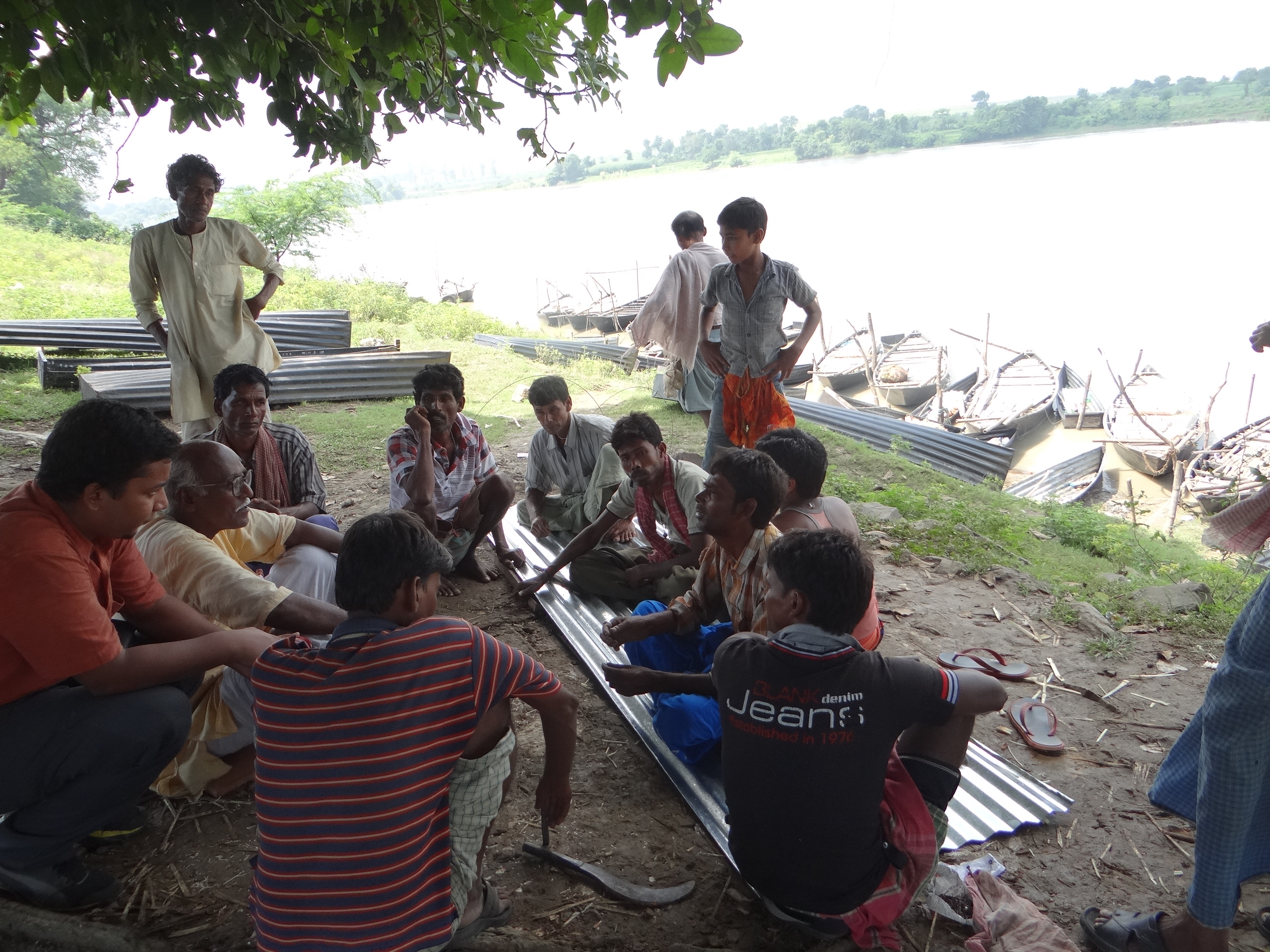
Fishermen upstream Farakka are a worried lot Photo: Author
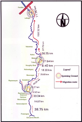
Prior to commissioning Farakka Barrage in 1975, there are records of the Hilsa migrating from Bay of Bengal right upto Agra, Kanpur and even Delhi covering a distance of more than 1600 kms. Maximum abundance was observed at Buxar (Bihar), at a distance of about 650 kms from river mouth. Post Farraka, Hilsa is unheard of in Yamuna in Delhi and its yield has dropped to zero in Allahabad, from 91 kg/km in 1960s. Studies as old as those conducted in mid-seventies single out Farakka’s disastrous impacts on Hilsa, illustrating a near 100% decline of Hilsa above the barrage post construction.[xiii]
We met fishermen who have not caught a single Hilsa in the upstream of the barrage despite fishing for three days. In the downstream too, size and recruitment (population) of Hilsa is affected due to arrested migration at Farakka. Some 2 million fisherfolk in Bangladesh depend on Hilsa fishing. Hilsa in Padma river (Ganga in India) downstream Farakka has also declined sharply due to decreasing water and blockage of migration routes.[xiv]
Lone Hilsa caught by a fishermen after three days of effort, sold for a pittance to local fish dealer. Photo: Author
These fisherfolk have never been compensated for the losses they suffered. They were not even counted as affected people when the barrage was designed and they are not counted even now.
Fable of Farakka Fish Lock
The tale of Farakka Barrage Fish Lock is another tragic story. Fish Lock is a gated structure in a Barrage that needs to be operated specifically to facilitate migration of fish from the downstream to the upstream or vice versa to breed, feed or complete their lifecycles.
According to Central Inland Fisheries Research Institute (CIFRI), Farakka Barrage has two Fish Locks between gates 24 and 25. The locks need to be operated to aid fish migration and transport fish. We talked with the Engineers at Farakka Barrage Authority, local villagers, fishermen and even the Barrage Control Room officials who operate the gates of the barrage about the functioning of the Fish Lock. No one had heard about a Fish Lock. There is some information that there is one more lock further upstream in the river, but the FBP Authorities did not seem aware of this.
The control room officials kept showing us the ship lock at the Barrage (which is also rarely used due to turbulence and sedimentation) and told us categorically that “There is nothing called as fish lock here”. The locks have not been operated for a minimum of a decade, possibly much longer.
Who is responsible for the loss of fisherfolk income in the meantime? Will the Farakka Barrage Authority or the MoWR or the CWC or the Kolkata Port Trust or Inland Waterways Authority of India compensate them?
Fisherman upstream Farakka Barrage. He says Hilsa is nearly wiped out from here and there is intense conflict for a meager catch. Photo: Author
According to Dr. Parua, fish locks were operated for some time when he was posted at Farakka, but they never worked as planned. He believes that a bare 60 feet fish lock for a barrage that is more than 2.6 kms long is of little use. There should have been more fish locks planned. He also lamented about the non-functionality of Hilsa Fish Hatchery set up at the banks of the barrage. (We were not even told about the presence of this structure by any of the officials or other concerned persons we met and possibly it has now fallen to complete disrepair now.) He said despite Central Inland Fisheries Research Institute (CIFRI) is based in West Bengal and has a special cell to study Hilsa, they or the Fisheries Department have taken no interest in the functioning of the hatchery or the Fish Locks.
2. Vikramshila Dolhin Sanctuary, Bhagalpur
Bhagalpur is barely 150 kms upriver from Farakka and Dr. Sunil Chaudhary, a past Member of the Sate Wildlife Board of Bihar has been working relentlessly on conservation of Gangetic Dolphins, as well as rights of traditional fisherfolk in Bihar and around Vikramshila region.[xv] SANDRP discussed the issue of Farakka and additional barrages with him. Dr. Chaudhary states that not only barrages, but the dredging itself will have serious impacts on Dolphins. Impacts of Farakka Barrage on fish and fisherfolk in Bihar is still being felt. No Hilsa reach here from Farakka and a generation of fisherfolk has suffered due to this. Forget more barrages on the Ganga, we need a review of Farakka Barrage itself as Ganga Mukti Andolan has been asking for years now.
Any work affecting Vikramshila Dolphin Sanctuary will require clearance from State Wildlife Board, State Wildlife Warden and National Board for Wildlife. We hope that such permissions are not given without due diligence and independent application of mind and at least whatever remains of Ganga is maintained.
In conclusion
The issues arising out of Farakka are extremely serious. Our planners and decision makers may claim that many of the impacts were not foreseen (Not entirely true). But the issue cannot be ignored any longer. We need a credible independent review of the development effectiveness of Farakka Barrage, including costs, benefits and impacts.
What we seem to be doing now is to repeat the mistakes of the past with new barrages planned on the Ganga.
The existing Upper Ganga Barrage (Bhimgouda Barrage) has dried up the river in the downstream. The river is diverted in a canal, where people take ritual baths, while the original riverbed is used as a parking lot.
Dry Ganga downstream Upper Ganga, Bhimgouda Barrage in Haridwar Photo: Author
The Lower Ganga (Narora Barrage) has severely affected fish migration & dried up the river in the downstream at least in lean season. The Barrage has a fish ladder, but there is no monitoring or concern as to whether it is working or not. In its report to the World Bank, Uttar Pradesh Government has said that the “condition of the barrage is poor” and has lamented about increased siltation in the upstream of the barrage and the inability to flush the sediments due to poor condition of its gates.[xvi].
Beyond doubt, the existing barrages, especially the Farakka Barrage have had massive impacts on the river, its ecosystems and its people. We have many critical lessons to learn from these experiences. In stead, we are pushing for more barrages on a river which will only compound existing problems.
Ganga is much more than a waterway or a powerhouse. It is a river, supporting not only urban areas and industries, but rural communities, the basin, the ecosystem and myriad organisms in its wake and it needs to be respected as an ecosystem first, rather than for sentimental reasons like mother or goddess.
The Ganga is being fettered at its origin in the Uttarakhand by over 300 hydropower dams. In addition, if it is again dammed many times over times in its main channel, then the government will not have to worry about River Rejuvenation Plan. There will be no river left for rejuvenation.
A Photo Feature on Farakka Barrage: https://sandrp.wordpress.com/2014/09/29/world-rivers-day-and-ganga-a-look-at-farakka-barrage-and-other-such-calamities/


 missioning Farakka Barrage in 1975, there are records of the Hilsa migrating from Bay of Bengal right upto Agra, Kanpur and even Delhi covering a distance of more than 1600 kms. Maximum abundance was observed at Buxar (Bihar), at a distance of about 650 kms from river mouth. Post Farraka, Hilsa is unheard of in Yamuna in Delhi and its yield has dropped to zero in Allahabad, from 91 kg/km in 1960s. Studies as old as those conducted in mid-seventies single out Farakka’s disastrous impacts on Hilsa, illustrating a near 100% decline of Hilsa above the barrage post construction.