Expert Appraisal Committee · Ministry of Environment and Forests

EAC rejects 2 VIDC projects from Buldhana for Violations

Expert Appraisal Committee, MoEF refuses to consider 2 VIDC projects from Buldhana for Environment Clearance siting violations

During its last meeting on 22-23rd March 2013, Expert Appraisal Committee of the MoEF has rejected considering two projects from Buldhana for violating EIA Notification (2006) and Environment (Protection) Act 1986. (see minutes here: http://environmentclearance.nic.in/writereaddata/Form-1A/Minutes/57_65thEACMiutes.pdf)

Location of Buldhana in Maharashtra

2 Irrigation Projects from Buldhana: Ar Kacheri Irrigation Project and Alegaon Irrigation Project, Vidarbha Irrigation Development Corporation (VIDC), were discussed for granting Terms of Reference (TORs). However, on the ground, both the projects have started work without an Environmental Clearance and this work was stopped only after strong local protests and even litigation. This was pointed out by the EAC and admitted by Vidarbha Irrigation Development Corporation. Together, both projects are set to submerge 436 hectares of forest and irrigated, cultivated land. Although 80% of the land under submergence is cultivated and irrigated by ground water, the Pre-feasibility reports (PFR) of the projects say that they will not cause submergence or affect population. EAC has pointed out this discrepancy too.

Alewadi project is just 1.75km from the core boundary of Melghat Tiger Reserve while Ar-Kacheri is 4.75km from the same. The projects have also received Stop Work order from the Forest Department in 2012.

Wan Wildlife Sanctuary from where Ar Nallah originates. Photo: Wikimedia

Despite all these serious issues, the project proponent chose to hide these facts from the EAC. SANDRP had sent a submission to the EAC prior to the meeting, highlighting many  issues and saying: “Considering the violations by both the project developers of EIA notification 2006 by starting work without the required clearances, the EAC should first recommend an enquiry into these violations and ask the responsible officials to be held accountable before even considering any clearance.”

The EAC has observed that both the projects have indulged in violations. According to the EAC: “Such cases are to be dealt in terms with the MoEF OM No. J-11013/41/2006-IA.II (I) dated 12.12.2012. Accordingly, the project proponent is required to submit an affidavit with an undertaking not to execute works without obtaining environmental clearance and furnish photographs of the site from all four sides of the project.” The OM also states for such violations, the State Government will have to take necessary legal action against the violations as per the Environment Protection Act. In case of serious violations, the MoEF reserves the right to reject projects all together.

Even as the White Paper on Irrigation Projects points fingers at Green Clearances as one of the reasons for time and cost overruns of irrigations projects in Maharashtra, the functioning of Water Resource Department itself has been responsible for these delays and irregularities. Without an Environmental Clearance, work on the project cannot start as per the EIA Notification 2006 and EPA 1986.

However, all Irrigation Development Corporations in Maharashtra have been breaking this law with impunity many times over. This was observed in case of Konkan Irrigation Development Corporation for several projects, Maharashtra Krishna Valley Development Corporation for numerous lift Irrigation schemes on Ujani and Vidarbha Development Corporation, for Lower Painganga Project.

With this decision, there is hope that VIDC and other IDCs in Maharashtra become less callous about issues relating to environment and affected communities.

Parineeta Dandekar parineeta.dandekar@gmail.com 

Himanshu Thakkar, ht.sandrp@gmail.com 

South Asia Network on Dams, Rivers and People


Cumulative Impact Assessment · Environment Impact Assessment · Forest Advisory Committee · Ministry of Environment and Forests · Western Ghats

Kalu Dam in Western Ghats: FAC goes back on its word without any justification

Through an unfortunate and short sighted decision, the Forest Advisory Committee of the Ministry of Environment and Forests has gone back on its decision of rejecting Forest Clearance to Kalu Dam that it took on 2nd April 2012. It reconsidered the project and in its last meeting on 3rd-4th April 2013, and has actually recommended the Kalu Dam project for FC, involving 1000 hecatres of Forests in the Western Ghats. It has done this when all the illegalities and irregularities from the proponent still stand today, entirely unaddressed.

We have sent a submission condemning this decision on behalf of Shramik Mukti Sangathana as well as villagers to be affected by Kalu Dam to the Forest Advisory Committee and Minister of Env and Forests Ms. Jayanthi Natarajan. (see below)
You can support the communities and Forests in Kalu by sending similar letters to MoEF Minister and Forest Advisory Commitee.

Illegal Work on Kalu Dam Site by FA Constructions Photo: SANDRP, May 2011


To,

Ms. Jayanthi Natarajan,

Minister of State (IC) for Environment and Forests,

Ministry of Environment and Forests, New Delhi


Subject: Request not to grant Forest Clearance to Kalu Dam in Maharashtra due to several procedural and legal irregularities on the part of the Project Proponent and also the Forest Advisory Committee.


Respected Madame Minister,

This is to express our utter shock and dismay at FAC’s decision of recommending Forest Clearance to Kalu Dam falling in Western Ghats area in Murbad, Thane District, Maharashtra as seen in the minutes of the FAC meeting of April 3-4, 2013.

Just one year ago on the 2nd of April 2012, the Forest Advisory Committee had rejected this proposal, raising substantial points against the proposal and closed the file. This was a respite for the communities facing displacement, community groups working on the issue, for the Western Ghats ecology and the forests. We had then thanked FAC for this decision of April 2012.

On 4th of April 2013, the same Forest Advisory Committee (now with a changed constitution) went back on its decision and recommended Forest Clearance (FC) to Kalu Dam even when nothing has changed on ground and all of the objections based on which FC was rejected in the first place still stand todayThe Project Proponent (PP): KIDC, Maharashtra Water Resource Department, has not been able to respond in credible way to any of the points raised by the FAC, Chief Conservator of Forests (Central), State Forest Department, affected villagers or civil society organisations.

We strongly condemn this decision by the FAC of recommending Forest Clearance for diverting nearly 1000 hectares of Forests in the Western Ghats. We urge you (i) not to recommend FC for Kalu Dam; (ii) request you to take steps to make Forest Advisory Committee more transparent, responsive and accountable to issues of communities and forests; specifically, all the documents from the project proponent, including all the annexures of the Form A and gram sabha resolutions for the projects on FAC agenda must be on FAC website at least ten days in advance as per CIC orders and as also assured by you in public; (iii) We also urge you to direct action against those responsible for illegal construction of the Kalu dam as noted by the FAC minutes; (iv) urge you ask FAC to hence forth recommend strict action against such violations.

 Major issues about recommending FC to Kalu Dam:

Non-transparent decision making in violation of CIC Orders: None of the documents submitted by the project proponent about the Kalu Project were available in full with all the annexures on the MoEF website even a week before FAC meeting on the 3rd and 4th of April. This is a blatant violation of the CIC orders and we had pointed this out to the FAC through our letter dated March 25, 2013, but the FAC chose to ignore this. As a Minister, you had taken a strong stand against this and had said in October 2012 “These actions and decisions of the officials are unacceptable to me. The forthcoming meeting of the FAC will be postponed, and I shall resolve these (violation of CIC orders and non-compliance of FRA) issues.”[1]

Considering that the lives and livelihoods of about 18000 people will be affected by this project, and when they have the first and foremost right to have all the information on decision making around this project, such irresponsibility on the part of FAC is unacceptable and it is also bad in law. Petition against Kalu Dam is in the High Court of Bombay currently and this point will be raised there.

Complete reliance on Project Proponent’s (PP) claims While recommending FC, the FAC has relied entirely on claims of the proponent, without checking the veracity of the claims or applying its mind. FAC has not even mentioned the numerous submissions made by communities and community-based organisations raising pertinent points against PP’s claims. The FAC needed to keep in mind that the same proponent has gone against its word many times earlier and each time, it has been pointed out to the FAC. It has wilfully violated the Forest Act by starting construction of the project in the absence of FC when the project is to submerge nearly 1000 hectares of land in a biodiversity hotspot, it has gone against its written word when it said that ‘no new project will be required for Mumbai until 2031”, in the process of seeking Stage I Forest Clearance for Shai Project, barely 20 kilometres from Kalu Project.

But the FAC, instead of taking any strict action against the proponent in this regard, has simply accepted its claims, which are again misleading and false.

Grounds for rejection of Kalu Project in 2nd April 2012 by FAC: The FAC minutes state:

·                    Submergence of 18 villages and their connectivity,

·                    Initiation of construction without Forest Clearance,

·                    Breach of commitment given by the Project Proponent during Stage I clearance of Shai Dam,

·                    Location of the dam within 7 kms of Protected Area

·                    Location of the project in eco sensitive Western Ghats

·         Non-furnishing of:  Rehabilitation Plan, Environment Impact Assessment report, Technical Report on Wildlife Status, Gram Sabha resolutions about compliance of Forest Rights Act


NONE of the issues stated above are resolved through the PP’s responses as clarified below:


·                    No Gram Sabha Resolutions Passed supporting the project:  Misleading the Forest Advisory Committee:  PP has claimed that it has secured Gram Sabha Resolutions from 8 villages out of the 11 villages that will be fully or partially submerged by the dam. In fact, Shramik Mukti Sangathana has letters from 10 Gram Panchayats out of these 11 that they have not issued any such resolutions at any stage. The last resolution in this regard that they passed was AGAINST the project. These were sent to the FAC on 16.11.11.

If the Project Proponent has the resolutions as claimed, why have they not put these up on the FAC website with the necessary documentation from the PP?

Why did the FAC not see the need to ascertain this even when it was pointed out by us in our letter dated 29.10.12 and again in 25.03.13 that no such resolutions exist?

·                    Clear violation of the Forest Conservation Act (1980): The proponent accepts that it violated the Forest Conservation Act (1980) by starting work before an FC, but states that it stopped AFTER High Court Orders. High Court Orders were in response of a PIL filed by Shramik Mukti Sangathana against the illegal nature of the work. So, stopping AFTER HC orders is no justification for committing the illegality. Before the High Court orders, Shramik Mukti Sangathana had written several letters about this violation to the Collector, Chief Secretary and Forest Department and had also served a notice to the PP. It did not stop work then.


Considering this, the Forest Advisory Committee ought to have penalised the project proponent for violation of Forest Conservation Act (1980), not recommend the same project for clearance.This only gives out a signal that no action will be taken by the MoEF even after it knows that violation of Forest Act is happening, that too by a state agency.

·                    Continued violation of the Forest Rights Act (2006) It has been pointed out several times to the FAC that Kalu Project is violating the Forest Rights Act (2006) as community and individual claims are yet to be settled. The Forest Rights Act was passed to safeguard historical injustice on Forest-dependent communities, but the FAC itself is encouraging the PP to violate FRA, PESA, Rehabilitation Policy and Forest Conservation Act. You, as a Minister, had reasserted MoEF’s commitment to implementation of Forest Rights Act.

·                    No Rehabilitation Plan has been submitted at the time of recommending Forest Clearance There is no such plan available in public domain, nor has there been any participatory process of approval of the plan with the affected people. A claim of a rehabilitation package of Rs 68.75 Crore does not constitute a Rehabilitation Plan. This point was raised several times by community organisations, State Forest Department, Chief Conservator of Forests as well as the FAC.  Villages to be affected by Kalu Dam fall in Tribal Subplan and attract PESA. Without any legally mandatory process, just the claim of rehabilitation package of Rs 68.75 crore seems good enough for FAC. It was clearly wrong on the part of the FAC to recommend FC based on such claims.

·                    Konkan Irrigation Development Corporations letter that “it is not necessary to construct any new water source till 2031”:  This was submitted to the MoEF while seeking Stage I Forest Clearance for Shai Dam, less than  25 kms from proposed Kalu dam in 2010-11. FAC recommended Stage I Clearance to Shai Dam based on that assurance. In less than 3 years, the proponent feels that Shai dam, whose clearance was obtained on such a claim, will not be sufficient till 2031. This is unjustifiable and tantamount to misleading the FAC with false assurances.

·                    No Environment Impact Assessment (EIA) Conducted The Kalu Dam falls in ecologically sensitive Western Ghats. The Western Ghats Expert Ecology Panel had categorised the region in ESZ I where no large dams should be permitted. Even as per the Kasturirangan Committee Report, more than 5 villages affected by Kalu Dam are falling in the ESA.

The State forest Department, Chief Conservator of Forests (Central), community groups have all urged that EIA as well as a Cumulative Impact Assessment of the Project has to be done before granting Forest Clearance. In fact, this was one of the conditions laid by the State Forest Department. Looking at the ecologically sensitive location of Kalu Dam and submergence of nearly 1000 hectares of Western Ghats Forest Land, this was a reasonable expectation.

Despite these clear conditions, the PP argues that EIA is not required. And despite this, the FAC recommends FC to this project!

In this context, Section 2.3 (ii) of FCA (1980) read, “Notwithstanding the above, if in the opinion of the Ministry or the Advisory Committee, any proposal should be examined from the environmental angle, it may be required that the project proponent refer the case to the Environment Wing of the MOEF.” So irrespective of the requirement of EIA notification, the FAC has been provided powers to refer to an such project to the environment wing of MoEF or EAC for examination of the project from the environment angle, but FAC failed to do this just under the claim of the PP that EIA is not required under EIA notification.

FAC recommendation that Cumulative Impact Assessment has to be undertaken for drinking water projects around Mumbai is welcome but again, it could have been done before considering this project for clearance and not after recommending clearance. Similarly their recommendation to the MoEF to amend the EIA notification to ensure that such dams are included for environmental impact assessment is welcome, but they could have waited for MEF response rather than recommending Forest Clearance.

In this regard we urge you: (i) immediately change the EIA notification to include Kalu and all such large dams under the ambit of the EIA notification, irrespective of the purpose of the project; (ii) Direct specifically that Kalu Dam require EIA and Env clearance, using the above mentioned part of the Forest Conservation Act, 1980 and EPA, 1986; (iii) Order a cumulative impact assessment of all the projects in the western ghats region around Kalu dam, as recommended by FAC and (iv) direct that FC for Kalu will NOT be considered till all these requirements are fulfilled.

·                    Forest Conservation Act requires Gram Sabha clearance Moreover, section 2.1(vii)(4) of the Forest Conservation Act, 1980 clearly states: “Therefore, whenever any proposal for diversion of forest land is  submitted,  it should be accompanied by a resolution of the ‘Aam Sabha’ of Gram Panchayat/Local Body of the area endorsing the proposal that the project is in the interest of people living in and around the proposed forest land except in cases wherever consent of the local people in one form or  another has been obtained by the State or the project proponents and the same is indicated in the proposal explicitly.  However, it would be required where the project activity on forest land is affecting quality of life of the people residing in nearby areas of the site of diversion; like mining projects, displacement of people in submergence area, etc.” This provision is particularly applicable to a project like Kalu that has not had EIA or public hearing as stated in the same section in FCA, 1980. Recommending FC for Kalu Dam project without fulfilling this requirement is clearly a violation of the FCA, 1980 by the FAC.

We urge you to direct the project proponent to get gram sabha resolutions on the lines mentioned above in FCA Section 2.1(vii)(4) and direct FAC consider the project only after these have been received.

·                    Distance from Protected Area: The submergence of the project is less than 10 kms from Kalsubai Sanctuary. Considering the fact that no EIA is conducted, no report on Wildlife Status exists, this makes ecological impacts of Kalu Dam on Western Ghats ecosystem even more serious. Considering all these issues, FC should have been rejected on this ground alone. In fact the PP goes ahead to say: “No rare or endangered flora or fauna has been reported from this site” How can this be stated when no EIA has been conducted and no wildlife report exists?

·                    The PP states that only “44566” and “44611” that is ‘only’  89177 tress will be felled during and the rest ‘may be’ saved. Ninety thousand trees in Western Ghats is a huge number. But it seems FAC does not see any objection in this. The claim that the rest of the 60 000 trees can be saved is of doubtful credibility. Similarly the claim in the FAC meeting minutes that “No rare or endangered species of flora and fauna has been reported in the area” is also without any credible basis.


·                    We would like to reiterate that no options assessment about water supply options to Mumbai has been done. No consideration of rainwater harvesting, using saline water for some uses, grey water recycling, demand management, water use efficiency, and conjunctive groundwater use has been done. The FAC minutes notes this, but from the minutes it seems it has not applied its mind to these issues and recommended FC as a matter of blind support for the project. The mention of the letter from the Chief Minister in the minutes only adds to the suspicion that the FAC has cleared the project without looking into merits of the issue.

·                    Contradictions in FAC conditions? The FAC has recommended FC to the project, with some additional conditions, one of the additional conditions states: “The User agency will abide by all conditions by Regional Office, Bhopal and State Government during inspection of the project.” So the PP has to adhere to all the conditions imposed by the Regional Office, Bhopal and the State forest Department while inspecting the project.

One of the conditions imposed by the Regional office, Bhopal included: “…the State Govt. may be directed to stop all the construction related activities till all the legal formalities and forest, wildlife and environment related studies are completed and a well-considered decision regarding forest diversion is taken based on proper scientific documentation and studies.”

We seem to be in a funny situation now. The FAC, while recommending FC, put a condition that says that decision of FC should not be taken without “proper scientific documentation and studies”, but FAC has done just that! In any case, one implication of this is that the project should not get even first stage FC without the studies recommended by Regional Office, Bhopal, including EIA has been done.

Similarly the State forest department too has asked for (i) Rehabilitation Plan (ii) EIA (iii) technical report from WII on impact of project on wildlife in and around the project area (iv) gram sabha resolutions from all affected villages under FRA. The project should not thus be given even stage I clearance without satisfaction of all these conditions.

Most of these issues have been brought to the attention of the FAC time and again by us, Shramik Mukti Sangathana and other community groups. However, the FAC still went ahead with the incomprehensible decision. Hence, we are writing to you with the hope that after looking at all the points raised above, you will definitely not recommended Forest Clearance to Kalu Dam. We also hope that MoEF will punish violators of FC and FRA Acts to send a strong signal and will take steps to make the present Forest Advisory Committee more transparent, accountable and responsive to issues ailing our forests and forest-dependent communities.

We will look forward to detailed response on this from you. Thanking you for your attention,

Yours Sincerely,


Indavi Tulpule: Shramik Mukti Sangathana, Murbad, Thane


Affected Villagers of the Kalu Dam:

Anil Kantaram Kawate: Parchonde (Upsarpanch)

Ganpat Deu Mengal: Zadghar (Gram Panchayat Member)

Navsu Shiva Wagh: Shisewadi

Mrs. Sonibai Shiva Wagh

Nama Shankar Shida: Banachi wadi

Maloji Alo Mengal: Bhoirwadi

 Mrs. Tulibai Wakh: Diwanpada

Bhagawan Bhala: Dighephal

Budjhaji Songwan: Wakalwadi

Anil Waman Wakh: Tejwadi  (Phangane)

Shivram Lakhu Hilam: Talegaon

Harbhau Raut: Kasole

Popatrao deshmukh: Jadai

Devram Darwade: Khutal

Ashok Pathare: Khutal

Tulshi Bhau Wagh: Zadghar

Moreshwar Bhala: Zadghar


Brian Lobo, Shramik Kashtakari Sanagthana: Dahanu

Surekha Dalawi, Shramik Kranti Sangathana: Raigad

                                                                                                                                                                                                Neema Pathak, Kalpavriksha: Pune 

Parineeta Dandekar, Himanshu Thakkar, South Asia Network on Dams and People: Pune and Delhi


Forest Advisory Committee · Ministry of Environment and Forests · Western Ghats

How much does the Kasturirangan Committee understand about Water Issues in Western Ghats?

The Ministry of Environment and Forests constituted the Western Ghats Experts Ecology Panel (WGEEP) in March 2010 under the Chairmanship of Prof. Madhav Gadgil. The Panel submitted its report on 31st August 2011. Here on, the report was kept under wraps by the MoEF and only after strict orders from the CIC and High Court was it released to the public in May 2012.

On Aug 17, 2012, MoEF set up the High Level Working Group (HLWG) under the Chairmanship of Dr. K. Kasturirangan to study recommendations of this Report. Members of this Committee include Sunita Narain, Prof. C.R. Babu, J.M. Mauskar, Prof. Kanchan Chopra, Shri Darshan Shankar etc. The HLWG was to look into the recommendations of the WGEEP report and the comments from the various stakeholders. The very constitution of the HLWG raised suspicions that this has been formed to dilute the recommendations of the WGEEP. The functioning of the HLWG left a lot to be desired, it refused to give time to listen to the affected people at many places. On April 17, 2013, after a number of extensions, the HLWG submitted its report. 

It seems the HLWG Report (HLWGR) has worked hard to hugely dilute the WGEEP reccomendations. In many cases, HLWG report has made the recommendations of the WGEEP report ineffective. No wonder, Prof. Madhav Gadgil himself has said: “ The initial impression (about HLWG Report) is that there are differences of approach in protecting the ecology of the region. The WGEEP report talks about the facts and we have pointed out that misgovernance is a major issue affecting the ecology of the Western Ghats. This was totally neglected in the new report, which calls for more role for bureaucracy. Providing more power and money to bureaucracy is like giving it to ‘Dusshasana’, and it is a wrong approach” . (http://newindianexpress.com/states/kerala/Kasturirangan-Committee%E2%80%99s-report-favours-bureaucracy-says-Gadgil/2013/04/20/article1553460.ece)


Dilution of WGEEPs strong recommendations is highlighted in the case of 200 MW Gundia Hydel Project in Karnataka and 163 MW Athirappilly Hydel Project in Kerala. While WGEEP Report has categorically rejected these projects based on their severe impacts on ecology and communities, the HLWG has refrained from doing so. The HLWG Report has gone ahead to recommend a few largely irrelevant, measures, while actually giving OK to these projects. Whatever suggestions of review HLWGR has given, the governments would be happy to do the necessary paper work and show that they have done that. The authors of the HLWG report seemed happy to toe the lines that government wants, rather than do justice to the mandate given to them. This was unexpected as both the projects not only have severe impact on ecology, but are also facing stiff and sustained local opposition. The HLWG Report does not seem to give any value or try to understand the reasons behind these local protests.

HLWGR has certified that Athirappilly Project is required for Kerala for peaking power. This is very strange certificate. Do we have an assessment of how much of the power generation from Kerala Hydro projects (incidentally Kerala has one of the highest proportion of installed power capacity under hydro projects, compared to any other state) today is providing peaking power? None. Do we have any credible attempt at ensuring more optimum peaking power generation from existing hydro projects in Kerala? None. Do we have any credible attempt at demand side management in Kerala to manage the peak load requirements? None. Have the KSEB and Kerala government implemented the orders of the Kerala High Court while HC rejected the environmental clearance to the Athirappilly project? No. Then on what basis has the HLWGR certified that “the project’s importance for meeting the peaking power requirements of the State cannot be disputed”?

The other recommendations of the HLWGR about hydropower development in Western Ghats are also problematic. It recommends environmental flows as 30% of lean season flow for hydropower dams, rather than asking for assessment of environment and social requirements of flow in the rivers. These studies cannot be done at a later stage as indicated by the HLWG. It makes no recommendations for flows in other seasons, including monsoon. The HLWG recommends that distance between 2 hydel projects should be minimum 3 kms, again without any basis. It should have asked for site specific studies rather than making such one-size-fits-all kind of recommendation, indicating lack of understanding of environmental issues. It should have at least mentioned ‘distance of free flowing river between two projects should be three kilometre”. Even in case of ROR projects, the submergence itself stretches for kilometres. Cascade hydel dam development which is devastating the Himalayas has not started in Western Ghats. Giving a recommendation like this is in fact inviting more cascades in Western Ghats, that too in the ESA.

The HLWGR has allowed what is it calls Green Growth in the Western Ghats area. But there is no credible process suggested as to who will decide this and how? How will such a process be achieved? Where is the road map to achieve it? The government itself calls all hydropower projects as green growth projects. It is shocking to read that HLWGR also describes all hydropower projects as clean and renewable, exposing their lack of understanding of the hydropower projects and their impacts. The HLWGR seems not bothered by the adverse impacts of such projects on the Western Ghats environment, this is clear in its recommendation agreeing to green growth projects without any credible process.

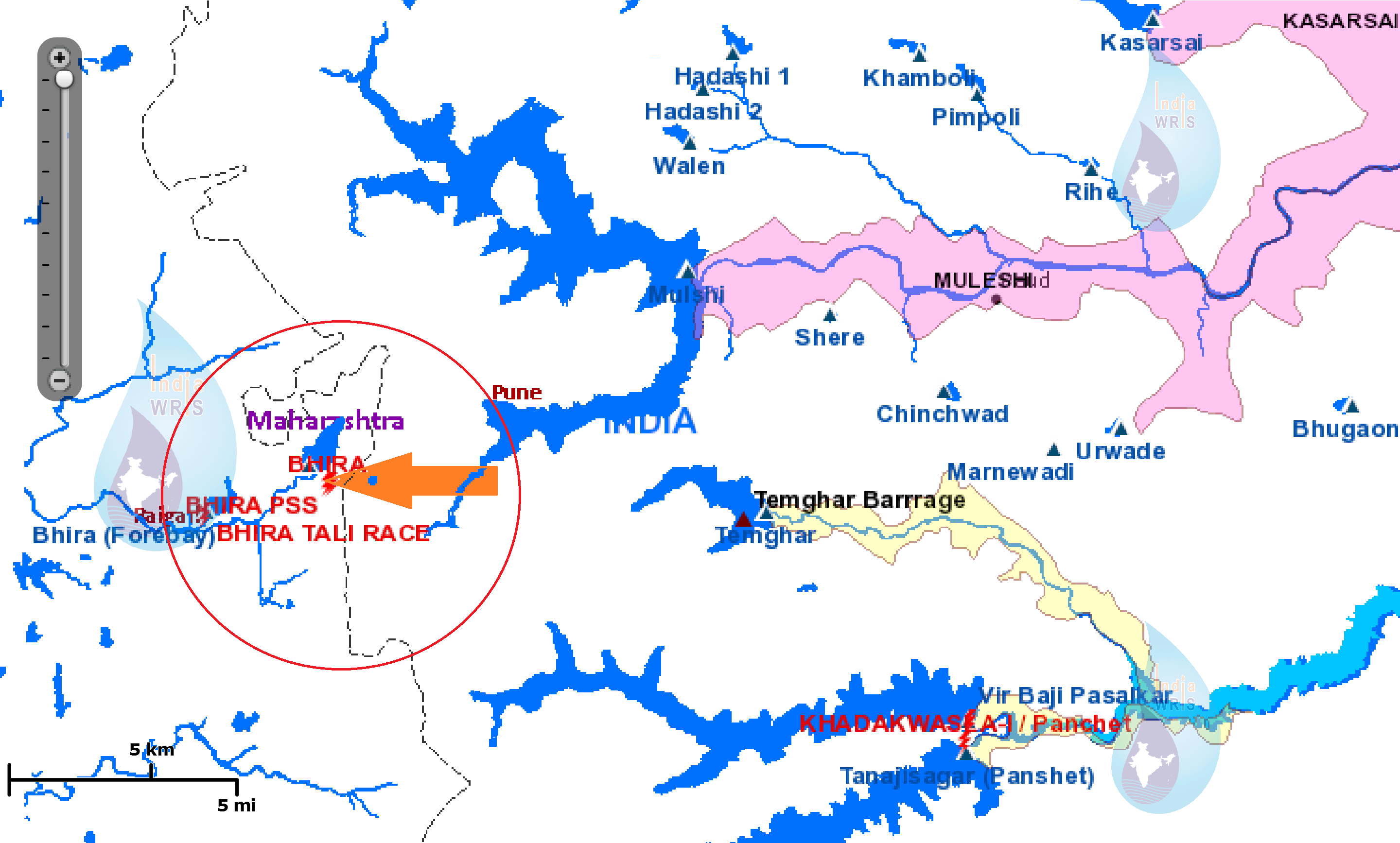
The HLWG has also not rejected Inter basin transfers from Western Ghats. In doing so, they have quoted justification that “Maharashtra that Rain Shadow Regions” need drinking water. Ironically, all the inter basin transfers happening in Maharashtra (Koyana and six Tata Dams) actually involve transfers FROM the rain shadow region TO water-rich Konkan region for power generation. But the HLWG Report says nothing about this Ulti Ganga. They should have actually recommended stoppage of these diversions if they had the interest of drought prone areas of Maharashtra in mind.

The HLWG Report is also entirely silent on the need to amend the EIA Notification 2006 to include Drinking Water and Industrial Water Supply Dams and Mini Hydel Projects below 25 MW and irrigation projects with command less than 10000 ha under the purview of this Notification. This has been one of the most serious challenges faced by Rivers in Western Ghats right now and the HLWG does not comment on this. It has not commented on dams like Kalu, Shai, Balganga, Lendhi, Gargai, Pinjal, Khargihill which will have a huge impact on Western Ghats ecology and communities. The extent of this damage is evident in the fact that in a recent Forest Clearance granted to Kalu Dam, the Forest Advisory Committee has asked the proponent to follow the recommendations of the Kasturirangan Committee Report. If only the report had made strong and proactive recommendations there was a chance of saving 1000 hectares of forests of Western Ghats

The HLWGR has not commented on fisheries at all.

While a more detailed critical look at the HLWGR will take time, this compilation puts before the readers exact passages from HLWG (see Section A below) and WGEEP (see Section B that comes after Section A) Reports for ready reference. It shows how much understanding of water issues the members of HLWG have or do not have.

– SANDRP

EXCERPTS FROM HLWG AND WGEEP REPORT ON WESTERN GHATS

A. High Level Working Group (HLWG) Report on Western Ghats (Kasturirangan Committee Report)

(HLWG Report Volume I, pp. XII-XXIII)

Out of the estimated 164,280 km2 of the Western-Ghats area, the natural landscape constitutes only 41 per cent. The area identified as ecologically sensitive is about 37 per cent i.e., about 90 % of the natural landscape.

1. Hydropower

Hydropower projects may be allowed in the ESA but subject to following conditions:

(a) Uninterrupted ecological flow at least 30 per cent level of the rivers flow in lean season till a comprehensive study establishes individual baselines.

(b) After a cumulative study which assesses the impact of each project on the flow pattern of the rivers and forest and biodiversity loss.

(c) Ensuring that the minimum distance between projects is maintained at 3 km and that not more than 50 per cent of the river basin is affected at any time.

The villages falling under ESA will be involved in decision making on the future projects. All projects will require prior-informed consent and no objection from the Gram Sabha of the village. The provision for prior informed consent under the Forest Rights Act will also be strictly enforced.

The strategy evolved for the continuation of the Western Ghats Development Programme, in the 12th Plan centres around, besides watershed based development, fragility of the habitat, and development needs of the people i.e. a Watershed + approach – an approach which emphasizes conservation, minimal ecological disturbance, involvement of locals along with sustainable model of economic development and livelihood generation with enhanced allocation.

2. Power/Energy, including hydropower and wind-

(HLWG Report, Volume I, pp. 106-108)

Hydroelectric projects, proposed and planned in the forested regions of the Western Ghats have often come in for opposition. It is clear that as much as the country needs hydroelectric power, which is renewable and clean, but it also needs to balance this requirement with the loss of biodiversity in forests and the need for ecological flow in rivers. Both are essential components and policy must determine that these elements are safeguarded. It is also clear that rivers in India play more than just basic ecological functions. These are lifelines for local livelihood, nutrition and water security. The desire to use the river for generating electricity cannot be at the cost of the value of the river. It is this balance that needs to be maintained. In fact, the potential of hydroelectric power has remained the sole driver for management of the river, particularly in its upper reaches. In the lower reaches, the use of the river for large-scale water diversion projects for irrigation and industrial uses becomes the criterion for development. But these single focus objectives must be enlarged so that the competing – and often the primary needs – can be taken into account at the time of planning and management.

It is also clear that rivers do not know boundaries. Therefore, the conditions for hydropower will be stipulated for the entire Western Ghats and not just for ESA. HLWG recommends that future hydroelectric projects in the ESA and the entire Western Ghats must only be considered on the basis of the following policies:

a. Hydropower development must be based on the acceptance of uninterrupted ecological flow at 30 per cent level of the rivers flow in lean seasons till a comprehensive study establishes individual baselines. The 30 per cent ecological flow is mandated in Western Ghats keeping in mind the shorter length of rivers in this region. The compliance with this condition will require rigorous and seasonal data collection in upper reaches of rivers to prepare a hydrological mapping of the basin. It is also clear that this hydrological assessment is critical given the changes in rainfall patterns because of climate change.

b. Hydropower projects must be considered only after a cumulative impact assessment on the flow pattern of the rivers and forest and biodiversity loss. Currently, individual projects are planned and executed without consideration of these impacts. The Environment Assessment Committees will only consider proposals for individual projects after cumulative impacts have been studied.

c. Current and future hydropower development in the Western Ghats must be based on clear rules that stipulate distance between projects and that do not allow for over-exploitation of the basin. The minimum distance between projects must be maintained at 3 km in most cases (shorter distance requirement because of the short length of the rivers in Western Ghats as compared to other regions) and not more than 50 per cent of the river basin should be affected at any time. This will require reworking the current projects to provide for optimized energy generation but it is necessary given the need to balance development with ecology.

d. Better and more balanced planning for hydropower will lead correct tariff of energy, taking into account the cost of raw material of water. Energy costs, world over, take into account the cost of raw material. It is imperative that the current subsidies and distortions in raw material supply for energy are minimized. It is in this context that water, as the raw material for generation of hydropower, must be factored in the project design. The ecological, social and cultural health of the river is a price that cannot be discounted at the time of planning for the feasibility of power.

e. There is a need to redesign and reevaluate small hydropower projects – below 25 mw as these often have limited impact on energy generation and can lead to huge impacts on ecology. The rationale for small projects must be considered within a policy framework, which provides for mini-grids and local energy distribution.

HLWG about Inter-basin transfers-

(HLWG Volume-I. pp- 100-103)

WGEEP recommendations for sector level planning and their implications

The WGEEP has recommended guidelines for sector-wise activities, which would be permitted in categorized ecologically sensitive area of the region. In this way, regions with the highest ecological sensitivity would have restricted developmental activities – from a total ban on mining to large hydroelectric projects or inter-basin transfer of water and even plantations. The listing is comprehensive and provides an important direction to what will constitute environmentally sound development in this ecologically rich region. The question is how such a development plan will be implemented. Furthermore, it is also important that environmentally sound development should be incentivized and not only practiced through fiat. It is also clear that this recommendation of the WGEEP has evoked the strongest criticism from many quarters. There is apprehension that this ‘blanket prescription’ could be detrimental to economy and livelihoods.

It is also a fact that permit-based regulations are often open for misinterpretation and misuse. A similar issue was raised with the High Level Group on its visit to Maharashtra, when officials explained that there was concern that the WGEEP, if implemented could lead to complete halt of all economic activity. “It would condemn people to live in stone-age”. According to them, the guidelines would not allow for any infrastructure development, from renewable energy to inter-basin transfer of water. This would be a problem, they explained, as many regions of the Western Ghats lie in the rain shadow area and need water to be diverted for irrigation and drinking. Clearly, their concern was the impact of the sweeping nature of the recommendations on the region’s economy. It is not possible to design an effective framework for sustainable development based on such an approach. It is clear that large -scale water diversion projects, which have impacts on the environment and forests, should not be allowed. However, this recommendation should not imply that all water diversion would be stopped even without any study or scrutiny about the individual project or cumulative impact of the projects.

HLWG recommendations for two hydel projects that were categorically rejected by the WGEEP Report

  • 163 MW Athirappilly HEP, Kerala:

HLWG is of the view that while the importance of the proposed Athirappilly hydropower project for meeting the peaking power requirements of the State cannot be disputed, there is still uncertainty about ecological flow available in the riverine stretch, which has a dam at a short distance upstream of the proposed project.

It recommends that given the increased variability due to unpredictable monsoon, the project must be revaluated in terms of the generation of energy and whether the plant load factor expected in the project makes it viable against the loss of local populations of some species. Based on this revaluation and collection of data on ecological flow, the Government of Kerala, could take forward the proposal, if it so desires with the Ministry of Environment and Forests.

The HLWG along with the officials of Kerala State Electricity Board and Kerala Forest Department visited the Athirappilly Hydropower Project, after hearing the presentations made by Kerala State Electricity Board (KSEB) and also a local NGO (River Research Centre, Trissur). The team visited the dam site, the settlement of Kadar tribes impacted by the dam, rapids and waterfalls and irrigation dam site. During presentation, the KSEB explained the upstream run of the river hydropower projects – the Sholayar project on the Sholayar river which is tributary of Chalakudy river, the tail water of which is discharged into downstream that flows into Poringalkuthu project which is on the main river itself, the tail water of which is discharged into downstream of Chalakudy river and is used for the proposed Athirappilly project which is about 40 km away from the backwaters of Cochin. All these projects are run of the river projects and there are no dry stretches of the rivers. If these streams/rivers are not dammed, the excess monsoon run off cannot be stored and enters into sea within 48 hours. The average annual inflow, based on 32 years data at Athirappilly, is 1169.Mm3. This is confirmed from the flow data of Chalakudy river at Arangals collected by Central Water Commission. The tail water from Athirappilly will be released into Chalakudy via its tributary at Kannankuzhithodu.

The fluctuations in the water flow in different months and the plant load factor were also explained. The issues relating to Kadar tribal families living close to the submergible portion of the dam were explained to HLWG and it was informed that a package has been worked out for their welfare without rehabilitation as the areas inhabited by them does not come under submergible zone. The NGOs, who met with HLWG, brought to its attention that project would have irreversible impact on the rich biodiversity value of the forest; particularly, along stretch of 7.89 km between dam site and the point where the tail race water joins Chalakudy river. They said that the habitat of the Kadar tribal population would be adversely hit and that people had not yet given their consent. In addition, they said that this project, being built in an area of biodiversity value, would have minimal benefits. The technical feasibility of the project was doubtful with meager amount of power obtained at high cost. In addition, plantation owners and farmer representatives located below the proposed project said it would have adverse impacts on downstream irrigation and drinking water.

The HLWG examined the status of forests, including the riparian forests and submergible slope forest, a small swampy area and the plantations. It is clear that as in all hydropower projects, there is a need to balance the need for energy, particularly peaking power, water supply and irrigation with the loss of biodiversity, forest habitat, displacement of tribal communities and the need for ecological flow in the river.

HLGW, after detailed deliberations on each of the critical issues, is of the view that while the project’s importance for meeting the peaking power requirements of the State cannot be disputed, there is still uncertainty about ecological flow available in the riverine stretch, which has a dam at a short distance upstream of the proposed project. Given the increased variability, in flow from catchments due to unpredictable monsoon rains, the project may be revaluated in terms of the generation of energy and if the plant load factor expected in the project makes it viable against the loss of local populations of some species. Based on this revaluation and collection of data on ecological flow, the Government of Kerala, could take forward the proposal if it so desires with the Ministry of Environment and Forests.

  • 200 MW Gundia HEP, Karnataka:

As the proposed Gundya hydropower project is located in the ESA, it must be proceeded upon with extreme caution. HLWG recommends that the Government of Karnataka should reassess the ecological flow in the downstream areas, based on a thorough evaluation of hydrological regimes in the area. The project should not be given the go-ahead, till such a review and reassessment is made. The Government’s review must also assess local damage to all forests, which will emanate from the construction work and if at all, this can be mitigated. The HWLG has not proposed a complete ban on the construction of hydropower projects in the ESA, but its recommended conditions that balance the needs of energy with environment, must be followed.

Background: The Karnataka Power Corporation Limited (KPCL) has proposed a hydroelectric project in the Gundya River basin in the Hassan and Dakshina Kannada district in two phases: Phase I of 1x 200 MW and Phase II of 1x 200 MW. The project is on Gundya river – a tributary of west flowing river of Netravathi; phase I involves pooling of waters by linking Yettinahole, Kerihole, Hongadhalla and Bettakumari and water from these streams will be intercepted by small weirs and will be drawn through a tunnel running from Yettinahole leading to Bettakumari reservoir. From the foreshore of this reservoir, 7.8 km long head trace tunnel takes water to a surge tank and from there to an underground powerhouse. The Phase II will have two tunnels – one tunnel will take water from Kadumanehalla and surrounding areas by 13 km long unlined tunnel and discharge into tunnel that takes water from Yettinahole weir, and another tunnel of 15 km long will take water from Lingath hole and Kumaradhara to Bettakumari reservoir. The submergible area will be 184.64 ha. An additional 560 ha will be needed for infrastructure. KPCL is not going ahead with the Hongadhalla dam because of the extensive submergible area of 523.80 ha. The project has got necessary clearances from different regulatory agencies; EAC of MoEF has asked KPCL to conduct also public hearing in Dakshna Kannada District, as project area falls in both the districts. The public hearing was conducted at Siribagiln village of Puttur taluka on 25.03.2009. Meanwhile the Malenadu Janapara Horata Samithi made a representation before the subcommittee of EAC during its visit to the site on 5.12.2009. The EAC has recommended clearance but the MoEF has not issued the environmental clearance.

The land required for the project includes forest area of 113 ha, revenue land of 263.63 ha, which also includes forests (though mostly degraded); and 71.5 ha of private land making it a total of 448.13 ha. The site has unique forest types with high biodiversity values (endemic, rare, threatened and new species) and also the cardamom and coffee plantations with scattered forest patches, which will be impacted adversely by land use changes and changes in hydrological regimes in the river basin due to project.

The major impacts of the project would be: (i) submergence of patches of riparian forest, (ii) land degradation/fragmentation of forest patches for tunneling and road construction; (iii) the drying up of down streams of three Yellinahole (with 60.50 km2 catchment area), Kerihole (27.00 km2 catchment area), Hongadahalla (8.50 km2 catchment area) and Bettakumari (35.00 km2 catchment area) before they join Gundya river, although each of them has small catchments, and a stretch of 34 km of Gundya river; and (iv) the apprehension of shortage of water at Subramanya Swami temple.

HWLG notes that the Gundya hydel project is run of the river project, which must ensure ecological flow in the affected stretch of the river. Furthermore, while the area of the submergible portion of forest is small, the construction of the project and tunneling in the region will have adverse impacts on both government forests and green areas on private land. As the Gundya hydropower projects is located in the ESA, HLWG recommends that it must be proceeded upon with extreme caution. It would recommend that the Government of Karnataka should reassess the ecological flow in the downstream areas, based on a thorough evaluation of hydrological regimes in the area. The project should not be given the go-ahead, till such a review and reassessment is made. The Government’s review must also assess damage to all forests, which will emanate from the construction work and if at all, this can be mitigated. The HWLG has not proposed a complete ban on the construction of hydropower in the ESA, but its recommended conditions that balance the needs of energy with environment must be followed.

B. WESTERN GHATS EXPERT ECOLOGY PANEL (WGEEP) REPORT

Athirappilly and Gundia Hydel projects

WGEEP Categorically rejects both the projects for their impact on communities and ecosystems.

Sectoral Recommendations relating to Water

Recommendations for ESZ I, II, III-

Decentralized water resources management plans at Local Self Government level Protect high altitude valley swamps and water bodies. Catchment area treatment plans of hydroelectric and major irrigation projects should be taken up to improve their life span. Improve river flows and water quality by scientific riparian management programmes involving community participation Water conservation measures should be adopted through suitable technology up gradation and public awareness programmes inter-basin diversions of rivers in the Western Ghats should not be allowed

Hydropower projects

For ESZ I-

  • Allow run of the river schemes with maximum height of 3 m permissible which would serve local energy needs of tribal/ local communities / plantation colonies subject to consent of gram sabha and all clearances from WGEA, SEA and DECs.
  • No forest clearance or stream diversion for new projects
  • Run of the river schemes not allowed in first order or second order streams
  • Promote small scale, micro and pico hydropower systems, that are people owned & managed and are off grid
  • New small hydropower projects (10 MW and below) are permissible

For ESZ II-

  • Small bandharas permissible for local and tribal community use / local self- government use
  • No new dams above 15 m or new thermal plants permissible
  • New hydro projects between 10- 25 MW (up to 10 m ht) permissible
  • All project categories subject to very strict clearance and compliance conditions through SEA and DECs of WGEA
  • Have run off the river hydropower projects but after cumulative impact study of the river basin is done

For ESZ III-

  • Large Power plants are allowed subject to strict environmental regulations including 1. Cumulative impact assessment studies 2. Carrying capacity studies 3. Minimum forest clearance (norms to be set by WGEA) 4. Based on assessment of flows required for downstream needs including the ecological needs of the river.
  • For already existing dams reservoir operations to be rescheduled for allowing more water downstream

Common recommendations for all the three zones-

  • No diversion of streams/ rivers allowed for any power projects and if already existing, to be stopped immediately.
  • Catchment area treatment in a phased manner following watershed principles;
  • Continuous non-compliance of clearance conditions for three years would entail decommissioning of existing projects
  • Dams and thermal projects that have crossed their viable life span (for dams the threshold is 30–50 years) to be decommissioned in phased manner
  • All project categories to be jointly operated by LSGs and Power Boards with strict monitoring for compliance under DECs

Fisheries

Recommendations for ESZ I, II, III-

  • Strictly control use of dynamite and other explosives to kill fish; provide fish ladders at all reservoirs Introduce incentive payments as ‚conservation service charges‛ for maintenance of indigenous fish species in tanks under control of Biodiversity Management Committees or Fishermen’s co-operatives; monitor and control trade in aquarium fishes with the help of Biodiversity Management Committees

Water use-

(WGEEP Report Volume II, pp. 32-37)

Water resources management in the Western Ghats region is inextricably linked to improving the flows in the rivers and the health of the catchments. Western Ghats is the origin of many of the important Peninsular Rivers like Cauvery, Krishna and Godavari that drain the Deccan Plateau and flow eastwards. The hundreds of shorter perennial monsoon fed west flowing rivers like Sharavati, Netravathi, Periyar, and the Bharathapuzha travel through steeper and more undulating topography before emptying into the Arabian Sea. A rough estimate reveals that 245 million people in the five Western Ghats states directly depend on these rivers for their diverse water needs. Geographically, the Western Ghats is the catchment for river systems that drain almost 40 % of the land area in India. The basin area of west flowing shorter rivers is mostly located on the steep western slopes. Except for a few coastal streams 1/3 rd of the basin area of most of the river basins is located within the Western Ghats. This too makes them fragile and calls for their proper care and management. Once these streams leave the Western Ghats proper, they are drained and enriched by the once fertile steep river valleys, midlands and flood plains. The coastal and backwater fisheries is sustained by the rich nutrients and sediments brought down by the flowing rivers. The musings by fisher folk in coastal Kerala: ‘The Sea begins in the mountains and ‘fertility of the coast and the plains depends on the wealth from the rivers’ holds significance in this context. Open dug wells and springs are the other important water resources being extensively used for irrigation and drinking water purposes in the Western Ghats region. In several places, water–‐ harvesting structures dependent on rainwater are also used. In the Sigur plateau, numerous drinking water schemes dependent on the Moyar River are being operated for the tribal and dalit populations. Bore wells have made their entry in the recent past due to intensive irrigation patterns and lowering of water tables. As for Kerala, the groundwater potential is low when compared to other states and shallow dug wells are the most common source of freshwater. However, over the years the groundwater table is lowering at an alarming rate indicative of poor recharging capacity. On the other hand, water needs for drinking water, energy, irrigation and industrial purposes are growing in the Western Ghats States. More and more water is being diverted even from irrigation dams to meet the thirst of the expanding urban spaces and for industries. We have examples of Siruvani, Kabini, Peechi and Malampuzha reservoirs across the Western Ghats where irrigation water is being diverted for drinking and for the industrial needs of cities in the midlands like Coimbatore, Bangalore and Mysore, Thrissur and Palakkad respectively. New dams are being planned and some of them are in different phases of construction in the Maharashtra Western Ghats to meet the expanding needs of Mumbai and its suburbs. Pinjal, Shai, Gargai, Kalu and Vaitarani dams are recent cases. Water abstraction through check dams across hill streams is being practiced for decades by tea and coffee plantations in upstream catchments of rivers to meet their drinking and irrigation needs. This has resulted in cutting off the stream flows at their origin itself. Indiscriminate and unplanned tourism is another reason for increasing water abstraction and diversion. The tourism industry in Ooty depends on the reservoirs constructed across the tributaries of the Cauvery in the high mountains since the times of the British. Studies reveal that east–‐ flowing Rivers like Krishna, Cauvery are struggling to reach the seas due to over abstraction of both surface and groundwater. Basins are closing and its impact is felt even on delta fishing, farming livelihoods and ecology. During the 2001-2004 drought years, the discharge from the Krishna to the ocean was almost nil! As for the west-flowing rivers, saline ingress is advancing even into the midlands due to reduced downstream flows. Crop losses and saline water intrusion into drinking water has been reported in Kerala during severe summer owing to salinity intrusion. In Goa, mining has affected groundwater and surface flows and drainage patterns of rivers impacting downstream needs and water quality. Tailings from mines are polluting streams and rivers. The Kudremukh mining issue is a classic case of mining- related pollution. This mountain range has a long history of human interventions and each of these have directly or indirectly impacted upon the water resources availability and recharge in the region. Some of the important interventions and issues that have had lasting impacts on water resources and its management in the Western Ghats are briefly discussed below.

Issues of Concern

Forest destruction in the river catchments

Western Ghats has a long history of deforestation. Deforestation of upper catchments of rivers for timber, river valley projects and plantations has drastically reduced the capacity of the hill streams that feed into the rivers to hold and recharge water. Drying up of streams immediately after the monsoons and desiccation related to deforestation is clearly evident. This in turn has contributed to reduced summer flows.

River management in the Western Ghats

Most of the rivers in the Western Ghats are either dammed or diverted, some of them at several sites for power generation in the upper reaches and irrigation in the lower reaches. For instance, the east–‐‑flowing tributaries of Cauvery (Bhavani, Moyar, Kabani) and Krishna (Bhima, Tunga, Bhadra) are already dammed. The west–‐‑flowing shorter rivers (Sharavathi, Periyar) have been dammed at several places. We also have complete diversion of river flows at Mullaperiyar and Parambikulam dams involving Kerala and Tamil Nadu. West-flowing rivers have been virtually made into east–‐‑flowing Rivers by violating all natural laws. Dams are without dispute the most direct modifiers of river flows. They can heavily modify the magnitude (amount) of water flowing downstream, change the timing, frequency and duration of high and low flows and alter the natural rates at which rivers rise and fall during runoff events. Severe daily flow fluctuation between peak and off peak times below dams is commonplace in west–‐‑flowing dammed rivers. This has impacted drinking water schemes, major and minor irrigation projects operating in downstream areas apart from cutting off flood plains and impacting aquatic ecology and riparian systems. However very few studies are available that correlate the reservoir operations with the different types of downstream impacts and put measures in place for mitigation. In the case of inter-basin water, no water flows or even

The Mullaperiyar dam is a classic case where the main tributary of Periyar has been completed diverted to the Vaigai basin in the east. Idukki dam does not even have a spillway for allowing monsoon spills into the river. In Maharashtra, the tail race discharges of Koyna Powerhouse I, II and III are released into the west–‐‑flowing Vashishthi River and lead to heavy floods in Chiplun. Continuous stretches of rivers have dried up irreparably below diversions affecting river ecology, surface flows and even ground water seepage. Many of the reservoirs especially in the steep valleys are silting up prematurely due to the massive encroachment and deforestation of catchments consequent to dam construction. Idukki dam is a classic case wherein the entire catchment was encroached along with dam construction. The operations of hydroelectric stations (reservoir operations) are in tune with the power needs rather than the downstream water needs. Hence daily flow fluctuations created by peak and off peak operations of reservoirs in dammed rivers have led to upstream- downstream conflicts in many river basins. Similarly diversion of flows into another river basin after power generation is creating problems of daily flood in the recipient basin and drought in diverted basins. These are turning into management issues which need to be addressed at a basin level. However, there is a lack of systematic river basin level data on ecological changes due to hydrological alterations created by dams.

Incorrect land use patterns

Mining for mineral ores, granite and lateritic mining has affected water availability and recharge especially in the lower altitude regions and midlands. In Goa alone, the government itself has acknowledged that over half of the 300 odd mining leases are located close to water bodies. Data tabled in the Goa Assembly revealed that several of the 182 mining leases exist within one kilometer of a major irrigation project, the Selaulim dam, which provides drinking water to six lakh people in south Goa, virtually half the population of Goa (Ref: Deccan Herald Article).

In South Karnataka and North Kerala, surangams, a traditional irrigation system in lateritic hills is losing out to lateritic mining. Many of the rivers in this region originate from these lateritic hills and many of the Western Ghats Rivers like Chandragiri, Valapattanam, and Netravathi benefit from the water recharged by lateritic hills in their flow downstream.

Agricultural practices including cropping patterns have a role to play in water resource management in the Western Ghats. Planting steep slopes with soil–‐‑eroding monocu;ture crops like rubber and banana, and heavy tillage, has led to increased surface runoff along with loss of precious top soil. This has contributed to low seepage and infiltration into deeper soil depths. The deforestation for tea, coffee and cardamom plantations located at higher altitudes has contributed to drying up of hill streams.

 Reclamation of high altitude valley swamps is contributing to water scarcity in the upper catchments. Many of the rivers originate from these swamps and are source of perennial flow. In the Nilgiris, most of the fertile water rich swamps have been converted for intensive pesticide-based farming, greenhouse farms, housing, etc.

Sand mining

Most of the rivers in Western Ghats are facing the consequences of indiscriminate sand mining. The lowering of water tables and deterioration of water quality are the immediate impacts. River beds in some stretches are lower than the sea level accelerating saline ingress. Drinking water scarcity is on the rise in river bank panchayats in spite of being close to the river. Plan funds are spent for providing drinking water even to panchayats on river banks. Sand mining has also impacted breeding and feeding grounds of fish and other aquatic species

Measures for Mitigation/Improvement

Time for river basin-­level planning and decentralised management of water resources in the Western Ghats As cited above, the impacts of incorrect land use and interventions are already evident. Reduced summer flows, flow fluctuations, lowering of water tables and degrading water quality are all direct impacts of the presently followed project–‐‑oriented, demand-supply based and ad hoc approach to water resource planning and management. The time is ripe for a paradigm shift in approach to river basin–‐‑level management of water resources where water is considered an integral part of the ecosystem. Some important measures that can be adopted in this regard are briefly detailed.

1. Local self–‑ government level decentralized water management plans to be developed at least for the next 20 years: Water resource management plans with suitable watershed measures, afforestation, eco–‐‑restoration of catchments, rainwater recharging and harvesting, storm water drainage, water auditing, recycling and reuse etc. should be built into the plans. These water management plans should integrate into basin level management plans. The objective is to reduce the dependence on rivers and external sources and to improve recharge.

2. Reschedule reservoir operations in dammed rivers and regulate flows in rivers to improve downstream flows and also to act as a conflict resolution strategy. These should be implemented with an effective public monitoring system in place.

3. Revive traditional water harvesting systems like recharge wells, surangams, etc.

4. Protect high altitude valley swamps that are the origins of rivers from further reclamation and real estate or agricultural development and declare them as ‘hotspots for community conservation’

5. Participatory sand auditing and strict regulations to be put in place.

6. Declare “sand holidays’ based on assessments and sand audits for mined river stretches. Items 5 and 6 would work to improve the water retention capacity in the river.

7. Rehabilitation of mined areas to be taken up by the companies / agencies with special focus on reviving the water resources like rivers, wells, tanks, etc. that have been destroyed by the mines.

8. Planters, local self–‐‑governments and Forest Departments in high altitude areas should come together for eco–‑restoration of the forest fragments between the tea and coffee estates and revive hill streams.

9. Take up catchment area treatment plans of hydro and major irrigation projects to improve their life span.

10. Riparian management can be taken up with community participation and involvement to improve river flows and water quality.

11. Water conservation measures should be adopted through suitable technology upgradation and public awareness programs.

12. Reconnect children and youth to rivers and water resources through basin level education programs.

Actionable points for the WGEA-

The (proposed) Western Ghats Ecology Authority (WGEA) can take a strong recommendatory and advisory role in this regard. Some of the important recommendations for WGEA are:

1. Declare origins of rivers as Ecologically Sensitive Localities (ESLs) (the catchment area)

2. Many projects in the Western Ghats are on–‐‑going or completed with violations in environmental clearance and forest clearance or even no clearances at all, as in the case of the Kalu and Shai dams in Maharashtra. The WGEA should act as an additional layer for screening projects approved by the Expert Appraisal Committees (EACs), subject them to additional scrutiny in terms of the geographical context, ecological sensitivity, status of river basin and need for environmental flows taking into consideration all season flows instead of ad hoc allocations.

3. Till the WGEA comes into operation, issue a moratorium on all on–‐‑going projects like dams and mines that can impact upon water resources in a substantial way. The WGEA should subject the projects to scrutiny for mandatory clearances and compliances, and augment the level of public consultation before deciding on whether to allow them to progress or not.

4. No more inter–‐‑basin diversions of rivers shall be allowed in the Western Ghats.

5. Take up sample river basins in each state and recommend to the State Governments to carry out:

  • Environment flow assessments involving social movements for river protection, research institutions, NGOs along with communities to put in place indicators for environmental flow assessment
  • Assessment of downstream impacts of dams on river ecology, flood plains, fishing habitats, livelihoods, etc.
  • Salinity intrusion mapping so as to suggest improved flows in future
  • Improve reservoir operations management in dammed rivers to improve meeting of water needs of downstream populations. Put proper monitoring of reservoir operations in place involving downstream local self–‐‑governments and departments.
  • Update and upgrade hydrological databases in rivers and consolidate the ecological database and information at river basin level
  • Based on the consolidation of databases, declare high conservation value stretches of rivers as ESAs and keep them free them from further development.

6. Recommend to State Governments to take up decentralized bottom􀈮up river basin planning with restoration built into the plans.

7. River Basin Planning should be supported by suitable legal institutions that are capable of integrating different departments which are presently dealing with or impacting on the rivers in a compartmentalized manner. Put in place river basin organizations adapted to state administrative context.

8. All new projects in the Western Ghats (dams, mines, tourism, housing, etc. that impact upon water resources) should be subject to cumulative impact assessment and should not exceed the carrying capacity.

9. Stronger and stricter laws for regulation of sand mining to be developed

10. Recommend the decommissioning of dams that have outlived their utility, are underperforming, and have silted up beyond acceptable standards, etc.

 Fisheries

 (WGEEP, Volume II, pp. 48-49)

Depletion of the fishery resources is a serious issue in the Western Ghats region. Compared to marine fish resources / biodiversity, the freshwater fish diversity is on the decline due to various reasons. Traditionally the conservation and management of fishery resources were vested with local communities, but this has now been altered. Several innovative measures are required to revive this highly valued resource and to use it in a sustainable manner on account of its relevance in livelihood improvement and food security. There is a need to readdress these issues with the fisheries department and other impacting sectors to reorient conservation measures in a participatory mode. Furthermore, local fish consumption has been a traditional source of protein for local people from time immemorial.

Issues of Concern

  • Habitat loss, including loss of mangroves
  • Pollution due to pesticides, industrial effluents/other sources
  • Waste dumping in rivers
  • Improper river maintenance and management
  • Unscientific methods of collection (use of poisons, electro–‐‑fishing, dynamiting etc.)
  • Impoundments in rivers, check dams
  • Introduction of exotic fishes
  • Destruction/loss of breeding grounds
  • Fish diseases
  • Overexploitation
  • Unauthorised ornamental fish trade
  • Sand mining
  • Excessive tourism activities in freshwater lakes
  • Decline of indigenous species due to introduction of exotic and alien fishes species

Measures for Mitigation/Improvement-

  • Regular monitoring of fish wealth to assess the health/ diversity of the fish population.
  • Banning the use of plastics which settle at the bottom of water bodies and lakes and affect breeding of some species.
  • Management measures aimed at conserving freshwater fish biodiversity to be incorporated into the fishery policy.
  • The database on population size and geographical distribution of endangered and endemic species should be strengthened by undertaking extensive micro–‐‑geographical surveys. Information on area of distribution and micro–‐‑geographical characteristics of the habitats of these ecologically sensitive fishes will be inputs for establishment of aquatic reserves for the conservation of these species.
  • Information regarding migration, breeding behavior and spawning grounds of threatened fishes should be generated through extensive surveys and analysis. Such a database is essential for both ex situ and in situ conservation of the species.
  • Techniques should be developed for the captive breeding and brood stock development of fishes of potential economic importance.
  • Brood stock maintenance centers and hatcheries should be established exclusively for indigenous, endangered and critically endangered fishes for their in situ conservation and aqua ranching as a substitute for their natural recruitment.
  • Investigation on the invasive nature of exotic species in the natural habitats should be carried out. The functioning of the committee constituted under the Government of India to quarantine and control introduction of exotic species should be made more effective and foolproof.
  • Strict vigilance and monitoring, including enforcement of laws, to be ensured to reduce the loss of the natural breeding grounds of the fishes arising from reclamation of paddy and wetlands.
  • Strengthen awareness programs to ensure the sustainability and survival of fish resources.
  • Regulation on fishing, during breeding seasons in freshwater environs to restore natural/ wild stock
  • Establishment of fish sanctuaries
  • Sand mining and other activities which destroy the habitat of many endemic fishes to be restricted.
  • Live–‐‑fencing using native plant species instead of stone walls to be encouraged for protecting river banks.
  • River Management Funds to be utilised for activities related to river health programs and not for construction or other developmental activities.
  • Regulation of ornamental fish collection from the wild.

Compiled by Damodar Pujari, SANDRP (damodar.sandrp@gmail.com)

Hydropower · Ministry of Environment and Forests · Ministry of Water Resources

LAKHWAR DAM PROJECT: Why the project should not go ahead

PRESS STATEMENT ON WORLD EARTH DAY: APRIL 22, 2013

We the signatories to this statement would like to bring some key issues to the attention of all concerned on the proposed Lakhwar Dam Project on the Yamuna River in Upper Yamuna River Basin in Dehradun district of Uttarakhand state.

The proposed dam involves a massive 204 m high dam with storage capacity of 580 Million Cubic meters, submergence area of 1385.2 ha, including 868.08 ha forest land, at least 50 villages to be affected by submergence of land in the upstream, many more in the downstream area. This site is just about 120 km downstream of the river’s origins from the holy shrine of Yamunotri.  The composite project involves, in addition to the Lakhwar dam with 300 MW underground power house, another 86 m high Vyasi dam with 2.7 km long tunnel and 120 MW underground power house and a barrage at Katapathar.

As can be seen from the details below:

a)      The project has not undergone basic, credible environment or social appraisal in any participatory manner.

b)      It does not have legally valid environment or forest clearance.

c)      There has not been any cumulative impact assessment of various existing, under construction and planned dams and hydro-projects in the Yamuna system.

d)      There has not been any credible assessment about options for the project.

e)      The project is to come up in an area that is seismically active, prone to flash floods and also prone to erosion and land slides.

f)       The spillway capacity of the project has been awfully underestimated resulting in significant risks of dam damage / breakage with concomitant risks of unprecedented downstream flooding and destruction. It may be mentioned here that Delhi is a major city standing in the path of the river in the downstream area.

g)      The religious and spiritual importance of the Yamuna River is at risk since whatever remains of the river will be completely destroyed both in the upstream and downstream of the project.

h)      No agreement exists among the Upper Yamuna basin states about sharing of costs and benefits of the project, which should be a pre-condition for taking up any such project.

i)        It is well known that Yamuna River is already one of the most threatened rivers in the country and the project shall further adversely affect the river system.

Recently as well as earlier last year thousands of people from Allahabad/ Vrindavan marched to Delhi, seeking a revival of their river Yamuna. The focus of the authorities should be on ways and means to restore the river Yamuna system rather than take such massive project without even basic appraisal.

We thus urge the official agencies at both the state and at the centre level to not go ahead with this project. We urge them to rather take steps to protect and preserve than destroy one of the biggest and culturally important river, without even basic appraisal at project or basin level or any options assessment carried out in a due participatory manner.

We hope that the government will not go ahead with this project until all the issues mentioned have been satisfactorily resolved.

Endorsed by:

Ramaswamy Iyer, Former Union Water Resources Secretary, Delhi, ramaswamy.iyer@gmail.com

E.A.S. Sarma, Former Union Power Secretary, Vishakhapattanam, eassarma@gmail.com

Medha Patkar, Narmada Bachao Andolan, Badwani, nba.medha@gmail.com

Ashish Kothari, Kalpavriksh, Pune, chikikothari@gmail.com

Rajendra Singh, Tarun Bharat Sangh, Rajasthan, watermantbs@yahoo.com

Prof. MK Prasad, Kerala Sastra Sahitya Parishad, Cochin, prasadmkprasad@gmail.com

Bittu Sahgal,  Editor, Sanctuary Asia, Mumbai bittusahgal@gmail.com

Prashant Bhushan, Senior Supreme Court Lawyer, Delhi, prashantbhush@gmail.com

Vandana Shiva, Navdanya, Delhi, vandana.shiva@gmail.com

10. Amit Bhaduri, Prof. Emeritus, JNU, Delhi, amit.bhaduri@gmail.com

Ravi Agarwal, Toxics Link, New Delhi, ravig64@gmail.com

Madhu Bhaduri, Former Indian Ambassador & member Yamuna Jiye Abhiyaan, Delhi, madhubhaduri@rediffmail.com

Prof S. Janakarajan, Madras Institute of Development Studies, Chennai, janak@mids.ac.in

Dr Dinesh Mishra, Barh Mukti Abhiyan, Bihar, dkmishra108@gmail.com

Sharad Lele, Centre for Environment and Development, Bangalore, sharad.lele@gmail.com

S. Faizi CBD Alliance, Kerala, s.faizi111@gmail.com

Rohit Prajapati, Paryavaran Suraksha Samiti, Gujarat, rohit.prajapati@gmail.com

Bharat Jhunjhunwala, Former Professor-IIM Bengaluru, Uttarakhand, bharatjj@gmail.com

Vimalbhai, Matu Jansangthan, Uttarakhand, matujansangthan@gmail.com

20. E Theophilus, Malika Virdi, Himal Prakriti, Uttarakhand, etheophilus@gmail.com

Ramnarayan K,  Save the Rivers Campaign Uttarakhand, ramnarayan.k@gmail.com

Kalyani Menon-Sen, Feminist Learning Partnerships, Gurgaon, kmenonsen@gmail.com

Dr RK Ranjan, Citizens Concern for Dams and Development, Manipur ranjanrk50@gmail.com
Jiten Yumnam, Committee on Natural Resources Protection in Manipur, jitnyumnam@yahoo.co.in

Renuka Huidrom, Centre for Research and Advocacy, Manipur, mangangmacha@gmail.com

Shweta Narayan, The Other Media, Chennai, nopvcever.new@gmail.com

Wilfred Dcosta, Indian Social Action Forum – INSAF, New Delhi insafdelhi@gmail.com

Nidhi Agarwal, Activist, Community rights on environment, Delhi, nidhi.sibia@gmail.com

Rahul Banerjee, Dhas Gramin Vikas Kendra, Indore, rahul.indauri@gmail.com
30. Subhadra Khaperde, Kansari Nu Vadavno, Khargone, subhadra.khaperde@gmail.com
Shankar Tadwal, Khedut Mazdoor Chetna Sangath, Alirajpur, shankarkmcs@rediffmail.com

Michael Mazgaonkar, Gujarat, mozdam@gmail.com

Ranjan Panda, Convenor, Water Initiatives Odisha, ranjanpanda@gmail.com

M Gopakumar, Bangalore, gopakumar.rootcause@gmail.com

Janak Daftari, Jal Biradari, Mithi Nadi Sansad, Mumbai, daffy@jalsangrah.org

Shripad Dharmadhikary, Manthan Ahdyayan Kendra, Pune, manthan.shripad@gmail.com

Prof Rohan D’Souza, Jawaharlal Nehru University, Delhi, rohanxdsouza@gmail.com

Dr Brij Gopal, Jaipur, brij44@gmail.com

Alok Agarwal, Narmada Bachao Andolan & Jan Sangharsh Morch, Madhya Pradesh, aloknba@gmail.com

40. Debi Goenka, Conservation Action Trust, Mumbai, debi1@cat.org.in

Shardul Bajikar, Editor – Natural History, Saveus Wildlife India, Mumbai shardulbajikar@gmail.com

Sankar Ray, Kolkata, sankar.ray@gmail.com

Samir Mehta, International Rivers, Mumbai, samir@internationalrivers.org

V Rukmini Rao, Gramya Resource Centre for Women, Secunderabad, vrukminirao@yahoo.com

Dr. Latha Anantha, River Research Centre, Kerala, latha.anantha9@gmail.com

Mrs Anjali Damania, Aam Admi Party, Mumbai, anjalidamania@rediffmail.com

Manshi Asher, Him Dhara, Himachal Pradesh, manshi.asher@gmail.com

Commodore (rtd) Lokesh Batra, Social and RTI activist, NOIDA, batra_lokesh@yahoo.com

Arun Tiwari, Water activist, Delhi, amethiarun@gmail.com

50. Ananda Banerjee, Writer and member, Yamuna Jiye Abhiyaan, Delhi,

Sudha Mohan, Yamuna Jiye Abhiyaan, Delhi, sudhamohan@peaceinst.org

Dr Sitaram Taigor, Yamuna Jiye Abhiyaan, Madhya Pradesh, srtchambal@gmail.com

Bhim S Rawat, Yamuna Jiye Abhiyaan, Delhi, we4earth@gmail.com

Prasad Chacko, Social activist, Ahmedabad, prasad.chacko@gmail.com

Swathi Seshadri, EQUATIONS, Bangalore, swathi.s@equitabletourism.org

Parineeta Dandekar, SANDRP, Pune, parineeta.dandekar@gmail.com,

Manoj Mishra, Yamuna Jiye Abhiyaan, Delhi (09910153601, yamunajiye@gmail.com)

58. Himanshu Thakkar, South Asia Network on Dams, Rivers & People, 86-D, AD block, Shalimar Bagh, Delhi (09968242798, ht.sandrp@gmail.com)


Annexure

DETAILED NOTES

1. No Options Assessment There has been no assessment to show that this project is the best option available for the services that it is supposed to provide, including water supply to Delhi, irrigation in Uttarakhand, hydropower generation and water storage. It was not done during the process preceding the now out-dated environmental clearance given in 1986, nor has it been done subsequently.

It is well known that Delhi has much cheaper, environment friendly and local options that has not been explored with any sense of seriousness. These include reduction in transmission & distribution losses (which stand at 35%), rainwater harvesting (as National Green Tribunal order in April 2013 exposed, even the Delhi Metro is not doing this) including groundwater recharge, demand side management, stopping non essential water use, protection of local water bodies, protection of flood plains, streams and the ridge, recycle and reuse of treated sewage, among others.

As far as irrigation in Uttarakhand is concerned, in this relatively high rainfall area, and considering the local agro-geo-climatic situation and suitable cropping patterns, better options exist. Similarly about other claimed services.

It may be added here that the EIA manual of Union Ministry of Environment & Forests, the National Water Policy and best practices around the world including the recommendations of the World Commission on Dams, require such an options assessment study, including no project scenario, before embarking on such costly and risky projects.

2. No Basin wide cumulative impact assessment or basin study: Yamuna River is already in very bad situation in many senses, including being very polluted for lack of surface water flow. The river basin also has large number of projects existing and under construction, See: http://www.sandrp.in/basin_maps/Major_Hydro_Projects_in_Yamuna_Basin.pdf, for details. Particularly, see the concentration of projects in narrow upper Yamuna Basin. However, there has been no basin wide cumulative impact assessment of projects and water use in the basin in the context of its carrying capacity on various aspects. Without such an assessment, adding more projects may not only be unsustainable, it may actually be worse than zero sum game, since the new projects will have large number of adverse impacts. That we may have already crossed the basin carrying capacity upstream of Delhi seems evident from the worsening state of Yamuna over the past decades in spite of investment of thousands of crores rupees. Adding this project with its massive impacts without such an assessment may actually be an invitation to disaster.

We learn that a Yamuna basin study has been assigned to the Indian Council for Forestry Research and Education (Dehradun). However, it should be noted that in the first place, ICFRE has had poor track record. Its EIA study for the Renuka dam in the same Yamuna basin was so poor that it was based on the poor quality of the study that the National Green Tribunal stayed the work on the project for over a year now.

3. No valid environment clearance, no valid EIA-EMP or Public consultation process

The Composite Lakhwar Vyasi project got environment clearance 27 years back in 1986 without any comprehensive environment impact assessment (EIA) or preparation of environment management plan (EMP) or any participatory process. Some preliminary work started, continued only till 1992 and stopped thereafter for lack of funds.

a) In Sept 2007, the 120 MW Vyasi HEP, part of the original composite project, sought and got environment clearance although the minutes of the Expert Appraisal Committee of MoEF notes a number of unresolved issues. In Nov 2010 EAC meeting, the EAC considered the Lakhwar Dam for Env clearance, and raised a number of questions, none of them were ever resolved. The EAC did not consider the project in any meeting after Nov 2010.

This sequence of events makes it clear that Lakhwar Dam does not have valid environment clearance. The MoEF and project proponent assumption that the Environment Clearance (EC) of 1986 is valid is not correct, since if that EC was not valid for the Vyasi HEP which has sought and received fresh EC in Sept 2007, then how  could Lakhwar HEP Dam of which Vyasi HEP is a part, continue to possess a valid EC.

Thus to give investment clearance to Lakhwar dam without valid EC will be imprudent, and might invite long drawn legal challenge to the project, resulting in more delays and in turn unnecessary cost escalations.

b) The project also does not have valid EIA-EMP. What ever assessments were done before the 1986 EC cannot be considered adequate or valid today. The environment standards and also environment situation has hugely changed in the intervening 27 years.

The project did not have any public consultation process in 1986 or anytime there after. Fresh EC will require that and the project must go through that process.

4. Issues raised by EAC remain unresolved: When the 43rd meeting of EAC considered the project for EC on Nov 12-13, 2010, the minutes of the meeting raised a large number of questions, all of them remain unresolved. These issues are fundamental in nature. Without resolving these issues, the project should not go ahead.

Just to illustrate, EAC raised questions about the need and usefulness of various project components. It is clear from the EAC minutes that the project also involves construction of Katapathar barrage downstream from Vyasi Power House at Hatiari. However, just about 10 km downstream from this barrage there is an existing barrage at Dak Pathar.  It is not clear why this Katapathar barrage is required, the EAC asked. None of these issues have been resolved.

5. Project does not have valid forest clearance: The composite Lakhwar Vyasi project requires a very large area of forest land, at 868.08 ha, the diversion was originally permitted for the UP irrigation Dept, which was then transferred to Uttaranchal Irrigation Dept upon creation of the separate Uttaranchal State. However, the project has now been transferred to Uttaranchal Jal Vidyut Nigam Limited. The Vyasi Project was earlier transferred to NHPC and now stands transferred to UJVNL.

In Aug 2012 FAC (Forest Advisory Committee is a statutory body under the Forest Conservation Act 1980) meeting, there was a proposal put forward to transfer the clearance for 99.93 ha (out of total forest land of Rs 868.08 ha for composite project) forest land required only for the Vyasi Project to UJVNL from Uttaranchal Irrigation Dept. While discussing this proposal, FAC noted that the Vyasi project was earlier transferred NHPC, without getting the forest clearance transferred in favour of NHPC. In fact FAC has recommended, “State Govt shall examine the reasons for not obtaining prior approval of the Central Govt under the Forest (Conservation) Act, 1980, for change of user agency from irrigation dept to NHPC and fix responsibility”. Secondly what is apparent from the minutes of the Aug 2012 FAC meeting is that even the Catchment Area Treatment Plan for the Vyasi project has not yet been prepared. This shocking state of lack of preparation of basic management plan is the consequence of allowing the project based on outdated clearances. The FAC has now asked the user agency to fulfil all such requirements, before which the project will not be given stage II forest clearance. So the Vyasi Project also so far does not have stage II forest clearance.

Most importantly, the transfer of forest clearance for the remaining 768.15 ha of forest land required for the Lakhwar project from Uttarakhnd irrigation dept to the current project agency UJVNL has not been even sought. So the Lakhwar project does not have valid forest clearance even for first stage, and surely no stage II forest clearance. Under the circumstances, the project does not have legal sanction.

6. Inadeaquate spillway capacity The project spillway capacity is proposed to be of 8000 cumecs, as per official website, see: http://india-wris.nrsc.gov.in/wrpinfo/index.php?title=Lakhwar_D00723. However, as per the latest estimates, the location is likely to experience probable Maximum Flood of 18000 cumecs. This is as per a paper titled “The probable maximum flood at the Ukai and Lakhwar dam sites in India” by P R Rakhecha and C Clark, presented in the year 2000 at an international Symposium. Dr Rakhecha later joined Govt of India’s Indian Institute of Tropical Meteorology in Pune. The paper concludes: “For the Lakhwar dam site there would be significant flow over the dam crest after 12 h from the start of the storm hydrograph and this would be maintained for over 18 h. The maximum depth of flow over the crest would be 4 m which is large enough to cause major if not catastrophic damage to the dam structure.”

Thus the spillway capacity of the project needs to be reviewed and it would not be prudent to go ahead without the same as the new PMF could cause major damage to the dam, the paper says. Any damage to this massive structure will have far reaching consequences all along the downstream area, right upto Delhi and downstream.

In fact even for the Vyasi HEP, while discussing the project in the EAC meeting of Aug 16, 2007, the minutes notes that the clarification sought by EAC on Dam Break Analysis for the project is incomplete, inadequate and far from satisfactory and the EAC desired further concurrence of Central Water Commission. In fact, EAC should not have recommended EC to the Vyasi Project with a flawed study. For the bigger Lakhwar project, there has not even been any such appraisal.

7. No agreement among Upper Yamuna basin states, Unresolved disputes The Lakhwar storage project is part of the Upper Yamuna basin. An interstate agreement was arrived at in 1994 for sharing of water in the Upper Yamuna basin among the basin states of Himachal Pradesh, Uttar Pradesh (now also Uttarakhand), Haryana, Delhi and Rajasthan. Each project under the agreement required separate agreements. However, there has been no agreement on sharing the costs and benefits of the individual projects under the agreement.

On Renuka project also in the same Upper Yamuna basin, there was an agreement that was arrived at in 1994, but the Ministry of Law has said that the agreement is no longer valid. For several years now the Upper Yamuna River Basin Board has been holding meetings, but has failed to arrive at any agreement for sharing the costs and benefits of Renuka dam. For Lakhwar dam there has been not been any serious attempt in that direction. The current project proposal envisages to provide 50% of water (about 165 MCM) to Delhi and 50% to Uttarakhand for irrigation (see: http://www.business-standard.com/article/companies/work-on-300-mw-lakhwar-project-to-begin-by-aug-112062200178_1.html dated June 22, 2012 includes statement from project proponent UJVNL (Uttarakhand Jal Vidyut Nigam Ltd) Chairman). However, this proposal completely ignores the claims of share from the project by Uttar Pradesh, Haryana, Rajasthan and Himachal Pradesh. To go ahead with the project without an inter state agreement on sharing costs and benefits would surely not be prudent.

8. Inadequate cost estimates As per estimate as on March 1996 the cost of the project is Rs 1446 crore out of which Rs 227 crore have been spent (see: official website http://uttarakhandirrigation.com/lakhwar_vyasi_project.html). Note that this cost was for the composite project, including Vyasi HEP. As per UJVNL official webstie http://www.uttarakhandjalvidyut.com/lakhwar.php, the cost of Lakhwar Project alone is Rs 4620.48 crore on Feb 2010. The same site gives the cost of Vyasi HEP at Rs 1010.89 crores, so the cost of combined project at Feb 2010 PL is Rs 5631.37 crores. The cost has thus seen 300% escalation in 14 years between 1996 and 2010. This is a very costly project and the cost is likely to be even higher at current prices. In any case, the estimate should be for current price level and the cost benefit calculations should also be for the latest date.

9. Seismically active area, erosion prone landscape: The project area is seismically active, flash flood, land slides, cloud bursts and erosion prone. In the context of changing climate, all these factors are likely to be further accentuated. When the project was first proposed in mid 1980s, none of these issues as also the issues of biodiversity conservation, need to conserve forests for local adaptation, forest rights compliance, environment flows etc were seen as relevant or important. However, all of these issues are important today. The project clearly needs to be reappraised keeping all these issues in mind.

~~

Dams

Why Solapur, Sugarcane and Sustainability do not rhyme?

As I build this dam

I bury my life.

The dawn breaks

There is no flour in the grinding stone.

I collect yesterday’s husk for today’s meal

____

The dam is ready

It feeds their sugarcane fields

Making their crop lush and juicy

But I walk miles through forests

In search of a drop of drinking water

I water the vegetation with drops of my sweat

As dry leaves drop and fill my parched yard

Daya Pawar[1] (Original marathi song Bai me dharan bandhte, majha maran kandte)[2]

The 2012-13 sugarcane crushing season (which goes on for 160 days [3] from roughly 15th October) has recently concluded. It may be instructive to look at the figures of the sugarcane crushed by sugar factories in Solapur, one of the worst drought-hit districts in the state. Presently, Solapur has more than 200 cattle camps, one of the highest in the state, and more than 141 villages which are entirely dependent on tankers for drinking water.

Solapur and Sugarcane: Solapur has the highest number of sugar factories in Maharashtra. During 2012-13 (latest crushing figures as on 11th April 2013), 126.25 Lakh tonnes cane was crushed in Solapur district alone in its 28 sugar factories[4]. The district accounts for the maximum 18.25% of the cane crushed in the state during 2012-13.  In 2012-13, a year that was called as a ‘drought year, worse than 1972 drought’, Solapur added 4 new sugar factories to its empire.

River basins of Solapur Normal monsoon (June-Oct) rainfall in Solapur district is 560 mm, in 2012 monsoon the rainfall was 412 mm[5]. Solapur belongs to five different sub basins as described by the Maharashtra Water and Irrigation Commission (MWIC) Report (June 1999). Among these five sub basins, the MWIC report describes 4 sub basins Bhima downstream Ujani (18B), Seena (19A) and Bori Benetura (19B) as highly deficient considering the water availability from all natural sources. Please see Annex1 Table 1 for details. 86.6% of Solapur district, barring parts of Karmala and Malshiras talukas, fall in this highly deficient river basins. The Commission says: “It is desirable to impose a total ban on water intensive crops like sugarcane in these deficit sub basins”. In these sub basins, “less water intensive crops only” and “less water intensive economic activities only” should be permitted, says the commission (p 138, Vol. III). Please see Annex 1 Table 2 for sub basin wise area of Solapur District.

Map-of-Maharashtra-Solapur

It means that sugarcane crop and sugar factories in all talukas of Solapur district, possibly except those in Karmala and Malshiras are unviable, in violation of the MWIC report and against prudent water management. There is some addition to the water available in these basins (18B, 19A and 19B) following implementation of Ujani dam and inter-basin transfers. However, that still does not justify any crops like sugarcane or setting up of sugar factories. MWIC clears states that additional water should be spread across the talukas to benefit maximum farmers. Sugarcane cultivation clearly will not help that cause.

Rise of sugarcane cultivation in Solapur “Sugarcane is a crop which exhausts the soil and, therefore, it is not grown in the same field from year to year but is rotated in alternate years with food-crops.” 

-District Gazetteer of Sholapur, 1977[6]

How rapidly the area under sugarcane in Solapur district has gone up can be seen from the graph (figures from official sources like http://mahaagri.gov.in and Sugar Commissionarate in Pune, 1961-62 and 1971-72 figures is from the Solapur district gazetteer and for 1992-93 from MWIC report). It is clear from the graph that the sugarcane area approximately doubled in Solapur during seventies and again during the eighties. Between 2005-06 and 2011-12, it seems to have gone up by over 160%, this is the highest growth phase for sugarcane cultivation in Solapur. That growth phase is likely to continue if we go by the number of new sugar factories that are planned to be set up in Solapur.

solapur_Sugar_Graph

DSC02239

The area under sugarcane in Solapur at its high in recent years was 1.79 lakh ha in 2011-12, which is 19.46 % of net sown area of 9.2 lakh ha in the district (see table 3 in Annex). Of the net irrigated area of 2.52 ha in Solapur, sugarcane takes away 71.03%, way above the prudent 5% prescribed in Maharashtra. It is clear that sugarcane has been taking away disproportionate share of water of the district, at the cost of the rest of the farmers.

Water Consumption of Sugarcane and Sugar factories Considering productivity of 81 tonnes of sugarcane per hectare[7], the cane crushed during 2012-13 occupied 155 864 hectares in Solapur. Considering that ratoon type of sugarcane requires 168.75 lakh litres water per hectare at farm[8], which is the lowest water requirement among all types, (40% of sugarcane in Maharashtra is under ratoon type cultivation), amount of water required for cultivating sugarcane on 155 864 hectares of area in Solapur works out to be 2630 Million Cubic Meters. This is 1.73 times the live storage capacity of Ujani Dam (Live Storage: 1517 MCM), the largest reservoir in Bhima basin and third largest reservoir of Maharashtra. Assuming a rather high irrigation efficiency of 60% (considering that most of the water comes from surface water sources) water required from source would be 4383 MCM[9]

For crushing 126.25 lakh tonnes of cane, the sugar factories used a minimum of 18.93 Million Cubic Meters of water between October 2012 and March 2013, when drought was already severe. The live water storage of Ujani reservoir, at its highest was in October 2012 at 14% and it rapidly receded to zero in January and sub-zero levels from January to March[10] (as on 21st April, 2013, it is -32.91%).This is a very conservative estimate as per guidelines of Central Pollution Control Board (CPCB), considering 1500 litres water required to crush and process one tonne of cane[11].

DSC02370

According to MWIC report, even with maximum possible augmentation (from all planned schemes, many of which are not even implemented or sanctioned), Solapur district’s total share of water is 4188 MCM. But the current level of sugarcane cultivation in Solapur already seems to be using more water than the ultimate planned water allocation for Solapur.

New Sugar factories planned in Solapur! To add to this, at least 19 new sugar factories (see details in Table 4) are planned in Solapur[12]. Many of these are private sugar factories and are owned by politicians. Sakhar Diary 2013 gives the locations and capacities of these factories. Some of these factories have also received distance certificates[13] from the Sugar Commissioner’s office, Maharashtra indicating that they are at an advanced clearance stage at the state level. Together, these new factories will add crushing capacity of 85.52 Lakh tonnes of sugarcane. Madha, part of the constituency of Union Agriculture minister Sharad Pawar, is in the forefront of getting new sugar factories. It has 3 existing factories and has 5 new ones planned, 2 by politicians.

To grow this 85.52 L T sugarcane, an additional 105 580 hectares will have to be brought under sugarcane cultivation. Additional 1782 MCM of water will be required at farm to cultivate this sugarcane. Assuming even a high irrigation efficiency of 60%, this would mean requirement of 2970 MCM water at source. In addition, the Sugar factories will require 12.83 MCM of water for crushing this cane.

The new planned sugar factories will bring total area under sugarcane in Solapur to 2.685 lakh ha and the annual water consumption by sugarcane and sugar mills over 7400 MCM. This is way above the full planned allocation of water for Solapur as per the MWIC report. MWIC assessment is exhaustive including all possible planned water schemes, so there is no possibility for Solapur to get water over and above the ultimate planned schemes in Solapur. This means that by going for these new sugar factories, Solapur would possibly taking water of other regions or accelerating towards rapid exhaustion of its available groundwater.

Sugarfactory

Even as farmers from Mohol region sat on dharna in Mumbai, urging Maharashtra government to release water for Ujani dam, the same Mohol block in Solapur district has 3 existing sugar factories. These factories crushed 13.56 lakh tonnes of sugarcane this year till March 2013[14], using 20,340 Lakh Litres of water from 15 October 2012, when the drought was already severe till March 13, when farmers from Mohol were protesting in Mumbai for drinking water. So even when farmers were protesting for drinking water, all the factories continued crushing in Mohol and the district administration, sugar Commissionerate as well as the state administration did not do anything to curb fresh sugarcane cultivation.

In addition, Mohol also has one more sugar factory planned[15] by a politician, with a capacity of crushing 6,40,000 tonnes of sugarcane, which will additionally require 133 MCM water at farm and 222 MCM water at source to cultivate this sugarcane and 9,600 lakh litres of water to crush this sugarcane.

Other drought affected districts Similar situation prevails in Osmanabad, Beed, Jalna, Parbhani in Marathwada which are reeling under severe drought and where drinking water itself has becomes scarce. Osmanabad crushed 26.35 LT of sugarcane through its 9 sugar factories[16]. Significantly, here the district Collector had written a letter in November 2012 to the Sugar Commissionerate to suspend cane crushing in Osmanabad in face of drought[17]. Nothing was done about that recommendation. To top this, 10 more factories are planned in Osmanabad. In the case of Beed, in addition to the existing 8 factories, 14 are in pipeline, Ahmednagar has 20 with 8 in pipeline, Latur has 12 existing and 5 in pipeline and Satara has 11 existing and 14 in pipeline.[18] Looking at the impact of existing sugar cultivation and factories on the water supplies in drought affected regions, the impact of these additional factories is difficult to imagine. The impact of water use and pollution caused by sugar factories and distilleries manufacturing alcohol will be additional.

Absence of credible sanctioning process for new capacities How did these factories get permissions from the Sugar Commissionerate which is the nodal sanctioning authority for sugar factories in Maharashtra? What role did the district administration play? What role do the Agriculture Department as well as the Water Resources Department play in this sanctioning process? What role do the farmers and people have in this sanctioning process? Who decides these are sustainable, just decisions? These are not just rhetorical questions. If prudent answers to these questions not found, Maharashtra water crisis may only get worse in days to come.

Enslaved to sugarcane With a growth cycle of 11-17 months, sugarcane cultivation locks up the farmers, the state and the system in a vicious cycle of irrigation at any cost. On an average, sugarcane requires irrigation twice a month. Once planted, the farmers have no choice but to look for all options to irrigate it. And the sugar mills have no options but to crush the sugarcane and the downstream water consumption lock in only grows. Since the whole product cycle is so long, once the crop is in place, everyone tries to get the necessary water to run the system, irrespective of drought, water scarcity, irrespective of impact on other sections of society or on long term sustainability. The whole state machinery is a slave to the survival of the sugar manufacturing process, it seems. Even the Comptroller and Auditor General, in its report for five years ending in 2007 have reported how the Sugar Commissionarate sanctioned capacities without considering water availability.

In this situation, it is very important to have credible checks before allowing more sugar factories or expansion of existing sugar factories. However, the basic checks and balances to ensure only sustainable sugarcane crushing capacity is installed seems to have completely failed in Maharashtra. There is no acknowledgement of this reality. In absence of prudent decision making process, the repercussions are bound to be painful and far reaching, the poor and likely to be the worst sufferers.

How much do the small farmers and poor benefit from sugar boom in Solapur? It is true that large number of small farmers and agricultural labourers, including dalits and other backward classes are also benefiting from sugar boom in drought affected districts of Maharashtra. However, a number of researchers have pointed out[19] that benefits to these sections are far less as compared to other sections. Secondly, the adverse impact of allocating most of available water to sugarcane on rest of the sections is disproportionately felt. For example, farmers near Bhima river in Helli village just as Bhima leaves Maharashtra say that most of the times, there is no water in the river and their weir never gets filled due to abstraction in the upstream. What about these small holding farmers? Today there does not seem to be even an acknowledgement of the collateral damage this sugar boom in Solapur and other drought affected districts is causing. As Osmanabad collector said, currently in villages with sugarcane, there is no drinking water. And as Daya Pawar’s poem given above narrates, it is the women of the poor sections that are facing the worst adverse impacts. Moreover, no one is asking how sustainable are these benefits and what will happen when even the sugar mills bust, as they are bound to?

Women trying to collect water from the dry Seena in Madha where 5 sugar factories will come up. March 2013. Photo: SANDRP

When Sweet Lime plantations over thousands of hectares died in Marathwada in the absence of water this year and when hapless farmers set their own horticultural plantations on fire as they could not bear to witness the wilting and dying trees they planted, sugarcane still continued to get water. So while there is a lobby to protect the sugarcane farmers, no such luck for other farmers.

Burnt Sweet Lime plantations in Osmanabad. Courtesy: Times of India

Once farmers have cultivated sugarcane, the sugar industries hide behind the farmers saying what will happen to the farmers if factories do not process this cane. While the risk of cultivating sugarcane and fighting for its water falls on the farmers, sugar industries are insulated from any risk, in the name of farmers and can continue crushing, using thousands of lakhs of litres of water and polluting even more water.

Is drip irrigation the ultimate solution? In the entire discourse on the costs and efficiency of sugarcane in Maharashtra, the water angle, which is of a paramount importance as demonstrated this year, is the most neglected. Institutes like Vasantdada Sugar Institute (VSI) (For every quintal of sugar generated by Sugar Factories, Rs 1 goes to VSI) and the Sugar Commissionerate seem strategically silent on this. When we contacted the drip irrigation cell in Vasantdada Sugar Institute to inquire about the area of sugarcane under drip irrigation, we were told by the person in-charge that Drip Irrigation Cell itself does not have these figures. This indicates either that this data is not available or they are not ready to share available information

Maharashtra Chief Minister and Commission on Agriculture Costs and Prices, Ministry of Agriculture have said this year that there is need to make drip irrigation mandatory for sugarcane cultivation in Maharashtra. This looks more like a band aid solution, which will continue the status quo of massive sugarcane cultivation in drought prone areas without asking if this is sustainable. In absence of such questions, drip irrigation could become a reason to continue to expand unsustainable sugar mills and sugarcane cultivation in drought prone areas, effectively using more water.

While claiming that Maharashtra has the highest efficiency of sugarcane in the country, it is forgotten that if crop duration and water consumption factors are added in the equation, Uttar Pradesh is more efficient than Maharashtra by a whopping 175%.[20] Maharashtra consumes on an average 1000 litres more water than UP to produce 1 kilogram of sugar.

In the end, while the High Court decision on releasing water for Ujani from upstream dams is welcome in one sense, the water releases from upstream dams is likely to be used up for the same unsustainable sugarcane cultivation in Solapur and along the way in Pune region. There is an urgent need to look at the bigger picture as to how in the water situation worsened so much in Solapur that the region producing most sugarcane does not have drinking water. Drought is a common phenomenon in this region for centuries, as described by the Solapur district Gazetteer. Solapur experiences drought once in every five years. In the context of climate change, rainfall will become more unreliable and drought more frequent. But if corrective steps are not taken about the unsustainable sugar boom in Solapur, we may be inviting worst disasters in future. These include encouraging sustainable cropping pattern including oilseeds, cereals and millets.

It is high time there is a public debate about why Sustainable Sugar won’t rhyme with Solapur other drought prone districts in Maharashtra.  There is an urgent need to stop setting new sugar factories in these regions, review the existing ones through credible independent process and ensure that lessons learned during the 2012-13 drought are not forgotten soon.

 -Parineeta Dandekar (parineeta.dandekar@gmail.com), Himanshu Thakkar  (ht.sandrp@gmail.com), with  inputs from Damodar  Pujari (damodar.sandrp@gmail.com)


South Asia Network on Dams, Rivers & People (https://sandrp.in/news)

_________

Annex 1


Table 1: Taluka wise Rainfall in Solapur district in 2012 monsoon (June-Oct)

Source: http://www.mahaagri.gov.in/rainfall/index.asp


Taluka Name

Normal Rain (mm)

Actual Rain (mm)

% To Normal

N. Solapur

617.3

465.4

75

S. Solapur

617.3

465.4

75

Barshi

596.5

551.8

93

Akkalkot

676.3

556.3

82

Mohal

573.9

316.4

55

Madha

534.4

435.5

81

Karmala

544

272.6

50

Pandharpur

573.7

360.4

63

Sangola

462.4

393.6

85

Malshiras

441.3

308.3

70

Mangalwedha

519.8

402.9

78

Solapur

559.7

412

74


Table 2 Sub basin wise area of Solapur district

(Area in sq km)

Note: Information from Maharashtra Water and Irrigation Commission, numbers in first column as per the same report; taluka wise area figures following http://solapur.nic.in


Sub basin No Sub Basin Name Talukas of Solapuar in the sub basin (area of the taluka in sub-basin) Area of Solapur in the sub-basin Solapur area in the sub basin as % of sub basin area
17 Bhima upto Ujani Karmala (930)

930

6.32%

18A Remaining BhimaNEERA Malshiras (1065)

1065

15.2%

18 B D/s of Ujani including Man Malshiras (457) + Sangola (1550) + Pandharpur (1304) + Madha (813) + Mohol (565) + S Solapur (146) + Mangalwedha (1141)

5976

57.3%

19 A Sina Madha (732) + Mohol (843) + S Solapur (718) + Akkalkot (80) + N Solapur (736) + Barshi (1483) + Karmala (680)

5272

41.37%

19 B Bori-Benetura Akkalkot (1310) + S Solapur (331)

1641

43.9%

TOTAL

14884


Table 3: Profile of Solapur district[21]

Area in ‘000 ha

Solapur

Geographical area

1487.8

Sown area

919.7

Net Irrigated area

251.5

Canal irrigated area

31.4

GW irrigated

193.5

Sugarcane area 2007-08

154.5

2010-11

163.1


Table 4: Taluka wise crushing capacities of existing and proposed sugar factories in Solapur

(crushing capacity in T/day)

Taluka

Existing sugar factories

Planned sugar factories

Number of Factories[22] Crushing Capacity Number of Factories[23] Crushing Capacity
Madha

3

11000

5

15000

Mohol

3

7500

1

2500

Karmala

3

6250

2

5000

Malshiras

5

19500

Akkalkot

2

6000

2

5000

Barshi

2

5000

1

2500

Mangalvedha

1

2500

3

9950

Pandharpur

4

12500

Sangola

1

2500

1

2500

North Solapur

3

10000

1

2500

South Solapur

1

2500

3

8500

TOTAL

28

85250

19

53450


Note: For some of the proposed factories where we could not get figures of crushing capacity, we have assumed it to be 2500 T/d, the normal minimum capacity. Source: Sugar Commissionarate, Pune


[1] From Staying Alive: Women, Ecology and Development, Zed books, Vandana Shiva, 1988

[3] Vasant Dada Sugar Institute Magazine DnyanYaag 2012

[4] Sugar Commissionarate Maharashtra: Crushing Figures as on 11th April 2013

[5] Please see Annex 1 Table 1 for Taluka-wise rainfall in the district during June-Oct 2012 monsoon

[7] Commission for Agriculture Costs and Prices, Ministry of Agriculture, Price Policy for Sugarcane, the 2013-14 Sugar Season Report: puts Maharashtra average productivity at 80 tonnes per hectare, Vasant Dada Sugar institute Report Dnyan Yag 2012 puts it 83 tonnes per hectare. We have assumed 81 tonnes/ hectare.

[8] Commission for Agriculture Costs and Prices, Ministry of Agriculture, Price Policy for Sugarcane, the 2013-14 Sugar Season Report: Chapter 5

[9] CACP chairman Prof Gulati clarified to us through email on April 21, 2013, the water requirement per Tonne sugarcane produced, as given in the CACP report is calculated at farm and the irrigation efficiency would depend on the source.

[10] www.mahawrd.org: dam storages

[12] Sakhar Diary 2013, a leading reference book for sugarcane cultivators and factories in Maharashtra.

[13] Certifying that the new factory locations are 25 km or more from the nearest existing sugar factories, as per the Dec 2012 notification from Govt of India.

[14] Sugar Commissionerate, April 2013

[15] Sakhar Diary 2013

[16] Sugar Commissionerate 11 April 2013

[18] Sakhar Diary 2013

[19] See for example Vandana Shiva reference above or http://www.academia.edu/172012/Growth_and_Poverty_In_Maharashtra

[20] CACP, Ministry of Agriculture Report, Chapter 5

[22] Source: Sugar Commisionerate Maharashtra, 2012-13 Crushing figures

[23] Source: Sakhar Diary 2013

Dams

How Efficient is Maharashtra’s Sugarcane Crop?

That question may sound slightly irreverent and irrelevant.

Maharashtra is the highest sugar producing state of India. Its sugarcane yield in 2011-12 was 80.1 t/ha, compared to the yield of 59.6 t/ha for the second highest sugar producing state Uttar Pradesh and national average of 70.3 t/ha. The average sugar recovery rate of the four sugarcane cultivation methods in Maharashtra was 11.32% in 2011-12, the recovery rate of Adsali sugarcane was even higher at 12.3%. The Maharashtra average was way above that of UP at 9.16% and all India rate of 10.2%. In fact the land productivity adjusted for recovery rate is even higher for Maharashtra at 98.8 t/ha (161.14 t/ha for Adsali) compared to 61.04 t/ha for UP. The yield per month when adjusted for recovery rate is 7.56 t/ha/month compared to 6.33 t/ha/month for UP.

DSC02055

 So with the highest production, high yield and high recovery rate, there should be no question of efficiency of Maharashtra sugarcane crop.

Indeed.

Methods of Sugarcane cultivation in Maharashtra Let us understand the basic parameters of how sugarcane crop is grown in Maharashtra, see the table 1 below.

 Table 1. Basic parameters of sugarcane crop in Maharashtra in 2011-12

Table_SugarcaneEfficiency

Source: Price Policy for Sugarcane: the 2013-14 Sugar season, Commission for Agricultural Costs and Prices, Ministry of Agriculture, Government of India, Aug 2012, Table 5.1

 Of the four sugarcane cultivation methods prevalent in Maharashtra, Ratoon is most popular with 40% cane area under it, possibly since it has shortest duration at 11 months, fitting almost perfectly with the annual Oct to March cane crushing season. Same can be said about Suru method, having duration of 12 months and coverage of 20%, both methods requiring 22.5 irrigations, each of 7.5 cm depth. Adsali method has the highest yield and recovery rate, but only 10% of the sugarcane area is under this method, possibly since it has the longest duration at 17 months. It is most water intensive, requiring 32.5 irrigations. Pre-seasonal method, as the name suggests, is planted about 2.5 months before the season, and stands between Ratoon and Adsali in terms of duration, yield and recovery rate.

DSC02339

 Water Productivity The latest report from CACP from which the above figures are taken, however states that land productivity alone does not give correct picture, “…as land and water are increasingly becoming scarce in India with high opportunity costs. Therefore, the real resource cost of growing sugarcane in different regions cannot be correctly compared unless land productivity is normalised for the time duration of crop, its water intake, and its recovery rate.” To make such a comparison, CACP made a table, a part of which is given above in Table 1.

 However, CACP has gone a step further than the figures in Table 1 (though there is an error in CACP calculations here, we have pointed this out to CACP). CACP has calculated water productivity of different sugarcane methods in Maharashtra and compared them with the water productivity in UP. The average water productivity of sugarcane in Maharashtra comes to 0.403 T/ha/month/’000 m3 water, compared to 1.11 for UP. This means that while UP seemed inefficient in sugarcane productivity in everyway, Maharashtra is inefficient by 175.43% when productivity per unit of water consumption is considered.

Dry Seena in Madha Block Solapur

 How is this possible? The reason why sugarcane productivity of UP in terms of water is higher is simple: UP sugarcane crop is of shorter 9-10 months duration and requires only 7-8 irrigations, approximately less than once a month. As against this, Maharashtra sugarcane crop requires irrigation every 15 days and that too for longer duration. To put it another way, while on average Maharashtra needs 25 irrigations for sugarcane crop, UP needs 7.6.

Water required per kg of sugar The CACP report further calculates that in Maharashtra every kilogram of sugar needs 2068 litres of water, where as in UP the requirement is almost half, at 1044 litres. This is indeed a telling figure. Add to it, as CACP report puts it, “real cost of water in Maharashtra is at least 2 to 3 times higher than that in UP”.

In response to a specific question, CACP chairman Dr Ashok Gulati wrote to me that this water calculation does not include the water used by sugar mills. If water used by sugar mills and water used in further downstream processing is included, the water consumption in sugar production is will go up substantially.

This analysis is very relevant for a state like Maharashtra that has much lower rainfall and per capita water availability compared to northern states like UP and Bihar. It is even more relevant when 79.5% of Maharashtra’s sugarcane is grown in drought prone districts as we showed in another blog.

How sugar mills lock up Maharashtra’s water future Considering water becomes even more important, looking at the kind of impact sugarcane cultivation is having in Maharashtra this drought season. Here it may be recalled that sugarcane is a long duration trans-season crop that has implications for water consumption beyond the point where decision for planting is taken. So even if the rainfall is normal or above when the crop is planted, the same crop will continue to have high water demand in the following year when it may be drought year. This creates really serious implications for water availability in the drought year particularly in drought prone, low rainfall areas. The impact on water available becomes even more serious in a state like Maharashtra where sugar mills are set up irrespective of water availability, violating the norms of distances, where sugar factories operate at way beyond their sanctioned capacity, where they violate the norms of no more than 5% of cultivable land under sugarcane, they dump untreated effluents into water bodies, thus polluting the water in such water bodies and so on. The lock in becomes even more stronger with the setting up of sugar mills, since their owners would like to get maximum cane every year, irrespective of water availability situation.

Sugarcane going to factories in drought affected Nagar District in March 2013

 The CACP report says Maharashtra is further worse off in terms of cost of providing water for sugarcane, “If this costing is included in calculating water productivity, the difference in sugarcane yields will be so high that, Uttar Pradesh and presumably Bihar, would turn out to be the most efficient producers of sugar per unit cost of water, adjusted for time duration and recovery.” CACP goes on to say that Maharashtra sugarcane grown on 3% of the total cropped area of the state, takes away 60% of irrigation water in the state, “leading to massive inequity in the use of water within the state”. These figures might be slightly outdated considering the expansion of sugar factories and sugarcane cultivation in recent years.

Band aid solutions won’t help One recommendation CACP report makes for Maharashtra is that much of sugarcane in the state must be brought under drip. Even the Chief Minister of State and the Union Agricultural Minister has made same recommendation. We are not sure if this is really a solution since this is unlikely to curb the unsustainable levels of sugarcane in drought prone districts of Maharashtra, considering the politics involved in the issue with large number of politicians owning sugar factories.

As per the Maharashtra Economic Survey figures for last two years, Maharashtra has provided subsidy for drip irrigation in 5.68 lakh ha and for sprinkler irrigation in 2.33 lakh ha between 2005-06 and 2011-12, thus providing subsidy for covering 8.01 lakh ha for these two techniques in these seven years. However, we see no impact of so much area under the drip and sprinkler irrigation on water situation in the state, nor do we see much of sugarcane under drip. State institute like the VSI does not even know how much sugarcane is under drip even though it has a section just for drip irrigation. More investment in drip for sugarcane is likely to give reasons for expansion of sugarcane empire in drought prone districts, in addition to opening the doors for more corruption.

 Another method called Sustainable Sugarcane Initiative can help the farmers to produce at least 20 per cent more sugarcane, and that too with 30 per cent of reduced water consumption and 20 per cent less chemical inputs. CACP report, though is silent on this.

DSC02239

Options like drip irrigation and sustainable sugarcane initiative should be explored for sugarcane cultivation in relatively water rich areas. However, in immediate future, Maharashtra needs to cancel all new licenses for sugar mills and put a halt to new mills and expansion of existing sugar mills in drought prone districts. For existing sugar factories, it needs to decide the level of sustainable sugarcane cultivation in each drought prone district through a transparent, independent process. Immediately in this drought year, no more water should be allowed to be used for sugarcane cultivation in drought prone districts.

Maharashtra faces a very challenging water future even if all these steps are implemented. Its water future is very bleak if no serious move is made in this direction.

Himanshu Thakkar (ht.sandrp@gmail.com)

South Asia Network on Dams, Rivers & People (www.sandrp.in)

References:

1. Price Policy for Sugarcane: the 2013-14 Sugar season, Commission for Agricultural Costs and Prices, Ministry of Agriculture, Government of India, Aug 2012 http://cacp.dacnet.nic.in/RPP/Sugarcane-2013-14.pdf

2. How is 2012-13 Maharashtra Drought worse than the one in 1972?, March 2013, SANDRP, https://sandrp.wordpress.com/2013/03/30/how-is-2012-13-maharashtra-drought-worse-than-the-one-in-1972/

3. Economic Survey for Maharashtra for 2011-12 and 2012-13

4. Sugarcane leaves farmers crushed, Business Line, April 15, 2013
http://www.thehindubusinessline.com/opinion/sugarcane-leaves-farmers-crushed/article4620505.ece

International Water Issues

Latest meeting of Committee of Secretaries: Govt of India pushes unviable hydro projects in North East Without due process

Latest meeting of Committee of Secretaries

Govt of India pushes unviable hydro projects in North East

Without due process


In a recently held meeting (see the latest updates on this issue from http://www.energylineindia.com/ on this below), the Committee of Secretaries have pushed for large hydro power projects in Arunachal Pradesh. As the agitation against the under construction 2000 MW Subansiri Lower HEP on Arunchal Pradesh border has shown any such move, without credible, independent and comprehensive options assessment, social and environmental impact assessment at project and basin level in a transparent and democratic way would prove to be disastrous not just from social and environment point of view, but also from economic aspects. Hurrying through such projects in the name of establishing prior use rights in the name of Chinese projects in Brahmaputra basin would not be helpful. The fact that the river and its ecology are in use by the people of Arunachal Pradesh, Assam, other North East and east India states, Bhutan and Bangladesh should be sufficient if prior use was indeed a tenable argument in international context.


Some new facts that have come to light from the CoS meet include:

  • According to the 9th report of the Inter-Ministerial Expert Group (IMEG), discussed during the course of the meeting, there has been an increase of three project sites on the mighty river since IMEG’s last report, prepared a few months earlier. A total of 39 Rune of the River projects/sites are now present on Brahmaputra and its tributaries.
  • Dam related peripheral infrastructural activity has gathered speed at Lengda, Zhongda and Langzhen, which are on the main course of Siang or Yarlung Tsangpo as it is called in Tibet. The Bome-Medog road which passes through the Great Bend Area is also being upgraded. The Joint Secretary, Ministry of External Affairs said that keeping in mind China’s bad track record to resolve water disputes, he was of the opinion that India should cooperate with other countries facing similar issues with China.
  • This report suggests that no instance of water diversion activities is discerned on the main course of the river and its tributaries.
  • Jiacha could be the next hydroelectric project on the mainstream of Brahmaputra River. It may be followed by hydroelectric projects at Lengda, Zhongda, Langzhen, where dam related peripheral infrastructural activity (including 4 new bridges) has gathered speed.
  • Dagu and Jiexu projects, which are also on the main course of Brahmaputra River, along with Nangxian project may see considerable development activity in future.
  • The China is carrying out series of cascading ROR projects in the· middle reaches of Brahmaputra, the same may be replicated in the Great Bend Area as a viable alternative to a single mega project and this needs further monitoring.
  • The CoS has directed the Technical Expert Group (TEG) to submit its action plan for establishing India’s user right within a month’s time. Cabinet Secretary directed TEG to submit a blueprint for action with indicative time lines within a month. CoS has recommended Additional Secretary, Ministry of Power to chair the TEG. Notably, the TEG along with other standing groups like IMEG, will continue to submit their six monthly reports.


Unfortunately, none of the reports of the TEG or IMEG are in public domain, nor are they available under RTI Act. The people of north east are kept in complete darkness about the decisions these officials take.


About the projects in the NE India, the CoS meeting noted:

  • Special Secretary, Water Resources, stated that 92 HEPs (above 25 MW) with aggregate capacity of 36,272.5 MW have been allotted of which about 20 are at some progressive stage of development.
  • While for 11 HEPs, aggregate capacity of 8,510 MW, the detail project reports (DPRs) have been submitted to CEA for examination, 9 projects worth 10,570 MW have been concurred by CEA.
  • In the case of Pashighat (2700MW) project, Techno Economic Clearance has been received and public hearing is scheduled next month.
  • Indeed as SANDRP analysis of functioning of EAC shows, the Expert Approval Committee has said yes to the largest of projects from Arunachal Pradesh.


An important agenda of the CoS meeting was to assess the progress of the measures suggested by the committee in its 4th meeting held on April 26, 2011. The committee had directed a Joint Steering Committee consisting of representatives from NHPC and Assam government to end the long standing deadlock at the 2,000 MW Subansiri HEP. Notably, the Joint Steering Committee has submitted its report in July 2012. In response to the CoS decision that Ministry of External Affairs (MEA) should firm up views on the modalities of initiating a more informed public debate on the issue of the Brahmaputra water diversion, MEA and MoWR have formed a joint mechanism to pursue the same. An FAQ has also been prepared on the subject to disseminate awareness. Apart from this, MoWR has initiated action on the decision of the CoS to hold informal discussion between concerned ministries for constructing multipurpose projects in Arunachal Pradesh. An inter-ministerial informal discussion was held in October 2011. An outcome of the meeting was that discussion of rehabilitation, an issue hampering many projects, should be project specific. Further, the Planning Commission has formed an Expert Panel to take up the sub-basin wise Environmental Impact Assessment (EIA) study under the chair of Chairman CWC which will submit its report this month.


Many of these actions of CoS and other related bodies clearly lack credibility. The Central Water Commission itself largely acts like a lobby for big dams in India and it is never known to have taken any credible steps for environment or EIA. Under the circumstances, the sub basin wise study that is expected from CWC would not have any credibility.


South Asia Network on Dams, Rivers & People (www.sandrp.in)


Some recent postings on this issue:
1.
http://tehelka.com/a-damned-race-for-power/#

2. https://sandrp.wordpress.com/2013/02/09/cutting-off-nose-to-spite-the-face-whose-nose-and-whose-face/

3. https://sandrp.wordpress.com/2013/02/11/india-pushing-for-a-water-treaty-with-china/

4. http://www.thehindu.com/news/national/expert-group-calls-for-monitoring-chinas-runoftheriver-projects/article4599260.ece

Dams

HC asks Maharashtra Govt to release water for Ujani: But will it help the drought affected?

Through its order on April 9, 2013 the Mumbai High Court has asked Maharashtra Govt to release water from upstream dams to  Ujani dam for mitigating drought in Solapur. The decision is welcome if the water released from upstream dam were to be used for the drought affected in Solapur. A division bench of Chief Justice Mohit Shah and Justice M S Sanklecha directed the government to release as much water as possible within 24 hours. The High Court’s order came in response to a PIL filed by a Solapur-based activist, Shankarrao Sathe. The PIL says that the Ujani dam gets water from the Bhima River which starts from Karjat in the Western Ghats. Between the source of the river and the dam, there are 20-22 dams.

Image

Highly-placed sources informed that soon after the High Court order, a high-level meeting was held in Mumbai to discuss the issue of release of water for Solapur as per the court orders.  Senior officials from Sinchan Bhavan in Pune attended the meeting which explored the options best suited for release of water to Ujani dam. The sources informed that it is likely that 2.5 TMC (70.8 MCM) water would be released from Bhama Askhed dam while half a TMC (14.16 MCM) water would be released from Andra dam, the WRIS map above shows the location of both these reservoirs. The water release would start from April 10, 2013, an official said. Bhama Askhed dam has design live storage capacity of 208.11 MCM and as per the latest (April 8, 2013) information, the dam had 124 MCM. Andra Valley dam has live storage capacity of 82.75 MCM. Both are irrigation and hydropower projects.

However, the moot question is, how much water would actually reach Ujani dam and how of that, how much water will really reach the drought affected people. Under the current circumstances, it is seriously doubtful if any significant proportion of the water released from upstream dams would reach the drought prone people, unless specific steps are taken to ensure the water is not diverted for non drought relief purposes.

Image

In that context, it needs to be noted that the water released from Bhama Asakhed and Andra Valley dams will have to travel about 250 km before it would reach the Ujani Dam. A very large portion of the water would be lost in evaporation and seepage and some also would be taken out by the enroute farmers as happened in the past with other water releases in Maharashtra earlier this year.

Moreover, Bhama Asakhed dam has irrigation potential of 29,465 Ha, but as per Irrigation Dept white paper, had irrigated area of just 434 ha by June 2012. The dam has 124 MCM storage now because it has not developed its irrigation potential over a decade since the dam has been completed. Why has that irrigation potential not realised? Pune has been eyeing water from Bhama Askhed for augmenting its water supply for a long time now, a demand backed by the same politicians who made mocked drought affected farmers.Similar questions also arise for Andra Valley dam.

Secondly, as per Solapur CADA website, the water level in Ujani dam as on April 9, 2013 is 16.74 TMC (474.3 MCM) below the live storage level. So even if the 3 TMC proposed to be released were to reach Ujani, the water level would still remain far below dead storage level.

Unfortunately, the Maharashtra Water Resources Department has never been able to control unauthorised use, let alone promote equitable usage of water from canals, dams and rivers. In our earlier blog, we showed how, even when it was clear that Maharashtra was going to face serious drought in 2012-13, no attempt was made to curb sugarcane farming, running of sugar mills or wine distilleries even when district officials have asked for such steps. This is also highlighted in the current drought, water conflicts in Manmad, in Nandur Madhyameshwar, in Mula Dam for Jayakwadi could not be resolved by the Water Resources Department.

With this background, though it is indeed a welcome decision that HC has ordered water release for Ujani from Pune Dams, it will be doubtful how much of that water will reach the purpose and area that it is meant for. The fact that all dams in a basin should have uniform water by the end of October is enshrined in the MWRRA Act 2005. It says:

Section 11: Power, functions and duties of the Authority states:

  • to determine the priority of equitable distribution of water available at the water resource project, sub-basin and river basin levels during periods of scarcity;

Section 12: General Policies of the Authority states:

in order to share the distress in the river basin of sub-basin equitably, the water stored in the reservoirs in the basin or sub-basin, as the case may be, shall be controlled by the end of October every year in such way that, the percentage of utilizable water, including kharif use, shall, for all reservoirs approximately be the same”. 

However, the establishment has made a mockery of this law by actually claiming that[1] MWRRA does not effectively exist as it does not have a Chairperson or expert members!

How can we then depend on the same WRD to ensure that water reaches Solapur and affected regions? When we know that the Khadakwasala RBC and LBC as well as Ujani RBC and LBC canal systems are leaking and in a state of dispair? That there are hundreds of unathorised lifts and siphons all along the way from Pune to Solapur?

Mismanagement and misuse of Ujani water has reached its new heights during this drought, when, the dam water was supplied water exclusively to sugarcane lobby and factories.

Under the circumstances, firstly, the High Court and the Govt of Maharashtra, in stead should consider the option of stopping the west ward diversion of water from the six Tata dams, as that would provide much more substantial water for the downstream Bhima basin.

Secondly, the High Court should also direct Maharashtra govt to formulate a policy for reservoir operations so that through out the filling period, there is sufficient water releases from all dams so that at the end of the monsoon, dams in any basin or sub basin have equitable water storage. This will ensure that High Court orders does not remain a fire fighting step, but has longer term implications.

The High Court would also need to ask the State govt as to what steps it has taken to ensure that the water released for Ujani actually goes to the deserving drought prone area and also what steps have been taken to stop the unjustifiable, unviable and unsustainable water use activities like westward diversions, sugarcane cultivation and sugar mill operations in drought period are stopped. Without all these steps, the welcome decision of High Court may not really serve the purpose it is supposed to serve.


Parineeta Dandekar(parineeta.dandekar@gmail.com), Himanshu Thakkar (ht.sandrp@gmail.com)

South Asia Network on Dams, Rivers & People (www.sandrp.in)


[1] Agrowon Newspaper, 29th March 2013


Dams

Bhima Water Crisis: Genesis and Way forward

Introduction Two weeks back I visited these farmers protesting at Azad Maidan and requesting for water to be released to canals (Right and Left Bank Canals of Ujani dam) for the Solapur district for their drinking water needs. They (there were women too)  represent Solapur Jilha Janahit Shetakari Sangathana (SJJSS). The man with prominent injury in the center is their leader Mr. Prabhakar (bhaiya) Deshmukh, who was publicly mocked at by no other than Maharashtra Dy. CM, Ajit Pawar on April 7, 2013 in absolute tasteless language. There can be different views over effectiveness of releasing the water from canals for drinking water needs in Solapur villages. Nonetheless, the public sentiments cannot be ridiculed by any one, leave aside the Dy. CM. Particularly when the Maharashtra government has some real options to solve the problems raised by Prabhakar Deshkukh.

Image

Solapur farmers on satyagarha in Mumbai for drinking water for two months Photo- SANDRP

Analysis Ujani dam, the biggest dam on Bhima River (Bhima river meets Krishna river in downstream Karnataka near Raichur), which supplies water to Solapur district, does not have any water left in its live storage – in fact, the attached graph shows that the level has gone in negative, which means the water level has gone below its live water storage capacity- in such case, judicious water consumption should have been the norm. It should have been adopted once it was confirmed by Aug 2012 that the area will be facing drought this year. Strict ban on sugar cane crushing, sugar cane plantation, effective water recycling, stopping westward water diversions from Bhima river, etc. are some of these options, none of which the administrators have perused with any seriousness.

Bhima before it reaches Solapur It is important to study the upstream situation of Mula, Mutha, Pavana and Bhima rivers before it flows down to Ujani dam. This first leads us to west-ward transfers of water from drought affected Bhima river basin to high rainfall (3000 mm or more annually) Konkan region for power generation. The attached maps depict this westward diversion projects. For hydro power generation, Tata Power transfers the water from these rivers across the Western Ghats through underground water tunnels, to the western side i.e. Konkan region which actually receives surplus rainfall. Such projects are highlighted in the Maps obtained from Water Resources Information System (WRIS). The six water reservoirs (Mulshi, Thokewadi, Shirawatha, Walwan, Lonavvala and Kundali), parts of the three Tata hydropower projects (150 MW Bhira, 72 MW Bivpuri and 72 MW Khopoli) could be seen on the eastern side of the dotted line which is Western Ghats ridge line.

Image

Figure 1– Bhira Power Project

Considering the fact that the downstream basin is reeling under severe drought, one must critically evaluate the question whether millions of cubic meters of water should be allowed to flow west into Konkan region.

Image

Figure 2- Khopoli Power Project        

Image

Figure 3-Bhipuri Power Project

Water supply in Pune district Pune is intersected by rivers Mula, Mutha, and Pawana which are tributaries of Bhima. In Pune and Pimpri Chinchwad region, there are 5 major dams which control the river flow downstream viz. Temghar, Panshet, Varasgaon, Khadakvasala and Pawana. There is Ujani dam in Solapur on Bhima River itself. It is indeed a cause of concern that the live storage in Ujani dam has reached in its negative capacity (-30%) when, upstream all these dams are showing quite healthy trend of water storage of their capacity. The following graph is compiled using the most recent available figures from Water Resources Department and Command Development Authority (CADA), Solapur.

Image

It is clear that while Solapur is reeling under sever water crises, Pune and Pimpri Chinchwad metropolitan area have adequate water supply. This situation raises question on the equity of our water sharing practices; not just on inter-state but even also on inter-district ones! In fact a case has been filed in which Maharashtra Water Resources Regulatory Authority is a respondent, asking for water release from upstream dams  in Pune for Ujani Dam.  In Pune district, apart from annual draft of underground 1015 MCM out of available 1442 MCM water[1], a study[2] on Urban water distribution states that, PMC is supplying so much water today that it would be sufficient to sustain Pune’s projected population of 2050[3]. There is unevenness in the water distribution with lack of well-designed inter-city water supply coordination. The demand for water has reached 1,164 MLD for Pune city. Water for the city predominantly comes from Khadakvasala dam. On the other hand, large part of the over 1.7 million rural population in Pune district are supplied the drinking water from tankers in March 2013[4]. The government officials claim that the district has enough water storage in the four dams to supply 1.5 TMC water every month till mid-July[5].

Water pollution in Pune district Pune’s record of sewage treatment has been one of the most dismal ones in India, pronmpting even the erstwhile Env. Minister Jairam Ramesh to write a strong letter condemning the Municipal Corporation. Pune Municipal Corporation admits that there is still a gap of over 250 MLD of sewage which is left untreated out of total 700 MLD generated[6]. In case of Pimpri-Chinchwad Municipal Corporation, the administration claims that there is about 50 MLD of sewage still being discharged into river untreated[7]. Experts believe that these figures are entirely misleading. Pune and Pimpri Chinchwad effectively do not treat even 25% of their sewage. Though Pune is required to do so, it does not return a single drop of recycled water into Khadakwasla Left Bank or Right Bank Canals for downstream usage. Pollution Control Board had filed a case against Pune Municipal Corporation in this regard, without any positive outcomes. Out of 30 stations across Maharashtra assessed by the Maharashtra Pollution Control Board for exceptionally poor Water Quality Indices, a whopping 18 stations lie in Pune.  The picture becomes even grimmer considering the fact that there are 25% of the population who are not connected by established sewage carrying mechanisms[8]. DO of Mula Mutha is routinely near zero is Pune and BOD and COD are extremely high. Even after building more than 6 sewage treatment plants, the condition has not improved.

Sugar mills and sugarcane cultivation Sugar factories also consume huge quantity of water and deliver surplus pollutants in the river. CPCB newsletter Parivesh confirms that sugar factories consume around 1,500- 2,000 liter of water and produce about 1,000 liters of sewage for every ton of sugarcane that they crush[9]. As on 28th February 2013, there are 27 operational cooperative sugar factories in Pune and Solapur combined[10] with total crushing capacity of 83750 tons/day. In addition, in the same region, according to government records, there are 19 private sugar factories[11]. It is not clear whether any of these  follow the rule of not establishing a sugar mill in 15 km circumference from any other sugar mill. The staggering figure of daily crushing capacity of 173250 tons/day imparted by 55 sugar cane factories in Pune division (not to be confused with district), leaves us wondering how much of water pollution they would have been caused[12].  In fact people from Daund and Indapur have been protesting about pollution from Pune for the past few years. Moreover there is the issue of massive water consumption by the sugarcane farms that cater to these sugar mills. Even as some of us travelled in these districts in this drought year, we could see sugarcane fields on both sides of the road as we travel from Pune to Solapur, as far as the eye could see. The plantation of sugarcane even after the declaration of drought continued and there was no attempt to curb that by anyone. Nor was there any attempt to stop the functioning of the water mills even in drought. There is of course the larger question of appropriateness of sugarcane cultivation and allowing sugar mills in this drought prone area. We learn that the administration has already sanctioned 31 more sugar factories in Solapur district.

 Conclusion There is a huge disparity between water availability  in Pune and Solapur districts.

  1. There is no effective machinery to ensure judicious inter-district water sharing.
  2. In the wake of severe drought also, we continue to divert our water to water surplus basins from water deficit Bhima basin
  3. Whatever water is left in the basin, Pune district degrades it, leaving the people downstream in Solapur demanding clean water in addition to their demand for supply of water in the first place[13].
  4. The addiction to sugarcane cultivation and sugar mills is very high even in the drought hit areas. In fact at least the crushing in Pune and Solapur districts should have been stopped right in October when it became clear that the state is going to face drought.

These conclusions also tell us that Dy. CM has a lot of options to work on instead of what he suggested in Indapur on 7th April 2013. The demand for water by Prabhakar Deshmukh and his organization cannot be brushed aside and certainly not in the fashion that Mr. Ajit Pawar did. In stead, he could have immediately directed stopping of westward diversion of water from the six Tata dams so that the water instead flows to the Ujani dam, which can than be used for providing water to the drought hit villages.

Damodar Pujari (damodar.sandrp@gmail.com)

South Asia Network on Dams, Rivers & People (www.sandrp.in)


[2] From Centre for Science and Environment

Ministry of Water Resources

India Water Week 2013: Another evidence of MoWR working like a big dam lobby?

India Water Week 2013

Another evidence of MoWR working like a big dam lobby?

It is well known that India’s water resources ministry in India and its offices like the CWC and NWDA work more like a big dam lobbies, now increasingly working for the private sector business organisations, rather than the communities that they are supposed to serve. If an additional proof was needed, it has become available in the form, content, inclusion and exclusion of the concerned groups in its India Water Week being organised at Vigyan Bhawan in Delhi during April 8-12, 2013.

Ministry of Water Resources, Govt of India, along with organisations likes Central Water Commission, Central Ground Water Board, National Water Development Agency, some related ministries of Govt of India are collectively organising India Water Week during April 8-12. Sponsors of the week long show include some state dam and irrigation organisations to private sector business organisations like L&T and Jain Irrigation and also hydro power company from neighbouring country like the Punatsanchu Hydropower Authority of Bhutan. The theme of this year’s event is: “Efficient Water Management: Challenges and Opportunities”.

The official website (http://www.indiawaterweek.in/) says about the event, “Ministry of Water Resources, Government of India have established a key annual policy and technology showcase event… The event is targeted at International and National audience comprising of policy planners and technologists involved with water resources management in all key sectors of economy”.

Further elaborate statement (http://www.indiawaterweek.in/html/aboutus.html) says something different, “the Ministry of Water Resources, Government of India have made a comprehensive plan for creating a unique platform for deliberating the issues involving all stakeholders including decision makers, politicians, researchers and entrepreneurs of water resources not only from Indian arena but also from International avenues”. So all stakeholders involved in India water sector are supposed to be participating in this. However, we see no sign of any scope for the most important stakeholders: farmers, women, tribals, fisherfolk or even critical voices from civil society. The organiser claims to have made efforts “for effective civil society involvement too in the consultative processes of India Water Week 2013”. We have not noticed any, but that must be our fault.

The registration fee: Who can afford? The fee is nominal: only Rs 8000/- per participant. Needless to add, the stakeholders have to make their own travelling and staying arrangements, not included in this registration fees. 99% of Indians cannot afford such fees, but we guess its not for them. The trouble, however, is that this is happening at public expense by the government of India agencies, in the name of people of India, most of whom cannot even participate it it.

The programme page of the official site (http://www.indiawaterweek.in/html/programme.html) opens with a telling statement: “Keeping in view the priorities of the Government of India towards making optimal usage of all the available water resources”. So, very interestingly, whatever the organisers are doing, is not only on behalf of water resources ministry and its subordinate offices, but the entire Government of India.

Commodification of Water That the event organisers equate water resources with water is apparent when they say: “the water resources are a single entity, which are shared by all the above sectors out of a common pool of utilizable water”. They simple do not seem to understand that water is an ecological good, embedded in the ecological entities and when water is taken out, it has consequences.

Enlightening definition of wide consultations What the Ministry understands by wide consultations is abundantly clarified by them. The Programme page says: “The theme for the event has been decided after wide consultations amongst the national and international level stakeholders and workers in the field. You can view the deliberations here.” When you click to view the deliberations, it takes you to: http://www.indiawaterweek.in/pdf/programme1.pdf. This page contains minutes of the meeting held on April 30, 2012, chaired by the Central Water Commission Chairman. It actually includes the list of 15 participants, and no prize of guessing that all, each one of them happen to be government officers! It is thus quite enlightening to know what is the meaning of wide consultations. Obviously those mortals who are not government officials have no place in the consultations.

National Water Policy It is learnt from the statements of the Union Water Resources Minister Harish Rawat that he will launch the new National Water Policy from the inaugural function on April 8, 2013. Here it should be noted that people of India have yet to see the final version of the new NWP, but those who pay the registration fees, will be first to see it! More importantly, it may be recalled that majority of the states that participated in the National Water Resources Council meeting held on Dec 29, 2012 opposed the policy. If one were to go by the latest draft available on MWR website (see: http://mowr.gov.in/writereaddata/linkimages/DraftNWP2012_English9353289094.pdf), the new policy is likely to advocate treated water as an “economic good”, encourage private sector to be service provider in public private participation mode and largely support business as usual practices rather than learn any lessons from past experiences. For more detailed comments on the new NWP draft, see: https://sandrp.in/wtrsect/Letter_to_NWRC_on_New_National_Water_Policy_Dec2012.pdf.

Buyer Seller meet for Dam Rehabilitation and Improvement Project There is an interesting session in the event with above sub title. DRIP is a World Bank funded programme managed by CWC for rehabilitation of some 243 dams that are more than 50 years old. The official programme website says, the objective of the event is to facilitate state dam agencies to get “exposure to state of the art technologies and solutions”. Its bit of a mystery what is going to be bought and sold, since even contours of the DRP programme are not in public domain. We hope, it is not about buying and selling of the old dams, as seems to be the case from the title of the session.

Hydropower A quick look at the detailed programme (see: http://www.indiawaterweek.in/html/event_plan.html) shows that the event will have four sessions on hydropower: 1. Water Availability and issues in development of hydro / thermal power 2. Hydro Power Green Power 3. Hydro Power Generation – Impact on Environment 4. Accelerated Development of Hydropower. The formulation, description and available names of moderators of these sessions clearly show how the MWR is acting like a big dam lobby.

For example, the page on first session (see: http://www.indiawaterweek.in/pdf/IWW-2013-IB2_30.pdf) does not talk about water availability issues at all, but about the huge untapped hydropower potential, like any lobbyist would do. The moderator is Mr A B Pandya, who is known to be proponent of big dams.

For the second session on Hydro Power Green Power (see: http://www.indiawaterweek.in/pdf/IWW-2013-IB2_49.pdf) the very title says that it is going to play the usual pro hydro jingle. Not surprisingly, the moderator is Mr Dasho Chhewang Rinzin from Bhutan’s Druk Green Power Corporation Limited. The session description includes, “Environmental Impacts of Hydro Projects need to assessed in proper keeping in view all aspects”. While former environment minister Jairam Ramesh, Assam Power Minister and many others are on record to have said that almost all EIAs in India are mostly dis-honest, cut and past jobs, to expect Managing Director of Bhutan corporation to moderate such a session is clearly inappropriate decision. It is open secret that Bhutan, in spite of its slogan of Gross Happiness Index, gives scant regard for social or environment issues of hydropower projects. Only where you can do that, can you get away with calling Hydro Power as Green Power.

For the Third Session on Accelerated Development of Hydro Power, (see: http://www.indiawaterweek.in/pdf/IWW-2013-IB2_42.pdf), the session is, to be moderated by the Chairman of Central Electricity Authority, which has been sanctioning every hydropower project that comes its way, without even fulfilling its  duty under Section 8(2) of India Electricity Act 2003, which asks CEA to evaluate the impact of the projects on basin wide context.

For the fourth session on Impact of Hydro Power on Environment (see: http://www.indiawaterweek.in/pdf/IWW-2013-IB2_15.pdf), the description actually talks only about positive impacts of hydropower on environment! Even about negative impacts, it says, “These impacts, however, may not necessarily be characterised as negative impacts”. The description actually shows how ostrich like the organisers are: “there is no universally accepted methodology for monitoring the downstream, reservoir or upstream ecological responses of the river systems”. They would not even like to acknowledge the existence of the report of the World Commission on Dams.

Session on Environment Flows It is indeed welcome to see the session titled: “Case for setting aside gains for environment flow”, though the title should be talking about gains from and not for environment flows. More worryingly, the organisers could not find anyone more credible than former Power Sector Shri Anil Razdan to moderate this session. Mr Razdan clearly has no environmental credentials and is rather known for his advocacy for more hydropower projects. This shows how insincere the organisers are on such vital issues.

There is only one more session on “Water Management and Sustainable Ecosystem” where there is likely to be some discussion on Ecosystem (see: http://www.indiawaterweek.in/pdf/IWW-2013-IB2_28.pdf). The session is to be moderated by Ms Sui Coates, Chief, WSH UNICEF. Good to see some representative of fairer gender at last. We hope UNICEF will in future speak up when dams destroy rivers, forests, biodiversity and livelihoods in future, which they have not done in the past, even though they are active in India.

In Conclusion: No-Water-weeks in India’s Drought Prone areas Even as the mandarins of water resource establishment host this multi crore  water week, very large parts of India, including parts of Maharashtra, Gujarat, Karnataka, Tamil Nadu and Kerala are facing drought and crores are people are suffering no-water-week, week after week. The organisers of India Water Week have clearly scant regard for these crores of unfortunate people. They may in fact join in chorus with Maharashtra Deputy Chief Minister Ajit Pawar (see: http://www.ndtv.com/article/india/ajit-pawar-apologises-for-shocking-remark-if-no-water-in-dam-do-we-urinate-in-it-351163) in mocking at these people. It would however be useful to remind them that Maharashtra is the state of India that has the highest number of big dams, more than a third of India’s big dams are in that state, and yet that state is claimed to be suffering drought worse than the 1972 drought, when the rainfall is much higher than the 1972 drought in most drought affected districts (for details see: https://sandrp.wordpress.com/2013/03/30/how-is-2012-13-maharashtra-drought-worse-than-the-one-in-1972/) and when the states has built close to thousand big dams in these 40 years. Big dams are not going to be solutions of India’s Water Future, they are actually going to create more problems and we need to find real solutions, beginning with some honest review of past experiences, which is what such event should start from. But the organisers of India Water Week seem in no mood for any such exercise.

Himanshu Thakkar (ht.sandrp@gmail.com)

South Asia Network on Dams, Rivers & People (www.sandrp.in)

Manoj Mishra (yamunajiye@gmail.com)

Yamuna Jiye Abhiyaan, Delhi (http://www.peaceinst.org/)


Dr Latha Anantha (rrckerala@gmail.com)

River Research Centre, Thrissur, Kerala


Parineeta Dandekar (parineeta.dandekar@gmail.com)

SANDRP, Pune


Shripad Dharmadhikary (manthan.shripad@gmail.com)

Manthan Adhyayan Kendra, Pune