Mississippi is a phenomenon. A large body of water flowing down a slope towards the sea is perceived as so many disparate things by different people at different times and places.
Some say that if you want to understand the continent, you have to understand this river. Some say this is no river, it is an Ocean. Some say its a Strong Brown God. Continue reading “Mississippi and the Singing River”→
PCA Final Order on India-Pakistan Kishanganga Dispute
India asked to increase environmental water releases to 212%;
India’s plea to re-interpret Feb 2013 order rejected;
Both countries asked to expand analysis & practices on e-flows
In a clear set back to Indian government stand, the Final Order of Dec 20, 2013 by the Permanent Court of Arbitration (PCA)[i] has not only asked India to increase the environmental water flow downstream from the dam at all times to 9 cubic meters per second (Cumecs) from the Indian government proposal of 4.25 cumecs (an increase of 112%), the PCA has also rejected Indian government plea to reconsider or re-interpret the PCA order of Feb 2013 that the 330 MW Kishanganga Hydro Electric Power Project (KHEP) under construction and all other subsequent projects cannot draw down the water level in projects below the dead storage level. (The accompanying maps are from the PCA Award in Feb 2013.)
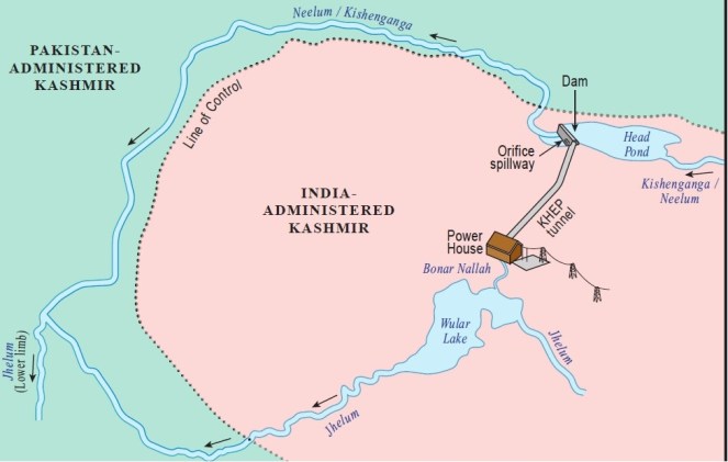
Kishanganga Hydro Electric Power Project Layout map
The dispute India’s 330 MW KHEP on Kishangana River (known as Neelum in Pakistan) in Jammu and Kashmir plans to divert the water of Kishanganga River to Bonar Nallah, which then flows to Wular lake. The overflow from Wular lake is known as Jhelum river, which then flows to Pakistan and meets Neelum River there. However, upstream from this confluence, Pakistan is building a 980 MW Neelum Jhelum HEP (NJHEP) on Kishanganga river, called Neelum in Pakistan, and diverting the water to Jhelum. Because of the diversion of water by KHEP, Pakistan fears its NJHEP will become unviable and had filed a case against India in Permanent Court of Arbitration, alleging that the KHEP was in violation of the India Pakistan Indus Water Treaty of 1960. As the official website of PCA says, “On May 17, 2010, the Islamic Republic of Pakistan instituted arbitral proceedings against the Republic of India under Paragraph 2(b) of Annexure G to the Indus Waters Treaty 1960. A Court of Arbitration composed of seven members has been constituted pursuant to Annexure G. The Permanent Court of Arbitration acts as Secretariat to the Court of Arbitration pursuant to Paragraph 15(a) of Annexure G. The Court of Arbitration is composed of: Judge Stephen M. Schwebel (Chairman), Sir Franklin Berman KCMG QC, Professor Howard S. Wheater FREng, Professor Lucius Caflisch, Professor Jan Paulsson, Judge Bruno Simma, H.E. Judge Peter Tomka”. On Feb 18, 2013, the Court gave partial award[ii], that resolved most of the issues, except that of the environment flows that India needs to release from KHEP. The Final award of Dec 20, 2013 is about the environment flows.
What India said about Environment flows “India’s experts examined the riverbed profile at 12 sites at one kilometer intervals from the KHEP to the Line of Control. At each site, India estimated the water level for minimum flows from 0 to 3 cumecs (at increments of 1 cumec), at 3.94 cumec, and from 4 to 10 cumecs (at increments of 0.25 cumecs), and replicated each calculation across the 99.99- percent, 90-percent, 75-percent, 50-percent, 25-percent and 10-percent dependable flow values. India’s experts then compared these depths to the minimum depths required by three umbrella species of fish: brown trout, snow trout and Tibetan stone loach. Based on these calculations, India’s experts conclude that: The reach between the dam and the first tributary is the most vulnerable to reductions in flow and the site at 6 km downstream show the 90th and 99.9th percentile flows as dropping below the minimum 0.5 m depth specified for brown and snow trout. However, Triplophysa [Tibetan stone loach] would have sufficient depths even with a minimum flow of 2.0 m3/s. Thus, the analysis indicates depths would drop below minimum depth requirements for trout species about 10 percent of the time in the upper 5.7-km reach below the dam. Downstream of this point, contribution of runoff from the tributaries will dilute the effects of the dam on flow regime.” (para 65) Based on this India told the court that even 2 cumecs flow would be sufficient, but they offered to release 4.25 cumecs as required by India’s Ministry of Environment and Forests (MoEF). It is not clear what is the basis for the 4.25 cumecs e-flows as mandated by MoEF.
Pakistan case on Environment FlowsPakistan had presented a more elaborate analysis of environment flow regime. The Award says about the Pakistan case: “In keeping with the DRIFT methodology and based on the predicted response of the indicators to various flow regimes, Pakistan’s experts graded the resultant ecological condition of the Kishenganga/Neelum under the 17 scenarios on a scale from A to F, ranging from pristine to critically modified. The results show that the current baseline condition of the Kishenganga/Neelum at the Line of Control is in low category B (near pristine). Various high release scenarios, for example a 20-cumec minimum flow and above, would maintain the river in category C (moderately modified from natural). Other scenarios, including a 10-cumec minimum flow, would achieve high category D conditions (significantly modified from natural), while a minimum flow of 3.94 cumecs and a maximum diversion scenario would reduce the river to low category D.” (Para 56) Pakistan concludes that between 20 and 40 cumecs flow releases should be required from KHEP.
Kishanganga Basin Map covering both India and Pakistan
PCA calls India’s analysis Simplistic and unsatisfactory PCA praises Pakistan analysis: “Pakistan has undertaken a far more extensive analysis, attempting to capture complex interactions within the river ecosystem. The Court notes that assessments of this nature are increasingly used by scientists and policymakers to bring a deeper understanding of ecology to bear on the management and development of river systems.152 In contrast, India has carried out a simpler assessment, drawing its conclusions essentially from a single indicator—the habitat available for selected fish species… Nevertheless, for a project of the magnitude of the KHEP, the Court is of the view that an in-depth assessment of the type that Pakistan has attempted for these proceedings is a more appropriate tool for estimating potential changes in the downstream environment… In contrast, the Court is not wholly satisfied that India’s consideration of the water depths available for fish and its associated analysis offer adequate assurances in light of the complexity of the ecosystem in the Kishenganga/Neelum.” (Para 98, 100)
PCA unconvincingly says E-flow of 12 cumecs is required In Para 103-5 the Award concludes, “as the release falls below 12 cumecs, the lowest flows at the Line of Control progressively become the norm for a significant part of the dry season… The Court provisionally concludes that an approach that takes exclusive account of environmental considerations—assessed in the absence of other considerations—would suggest an environmental flow of some 12 cumecs… And if Pakistan’s hydro-electric uses alone were to be taken into account, moderating the KHEP’s effect on the NJHEP might entail even higher releases.” The PCA analysis as to how it reaches this conclusion is not very convincing, since this is protecting only the minimum flows and not looking at the river as an ecosystem that would require a range of flows. While KHEP may be passing occasional surpluses above 9 cumecs E-flow releases beyond what it cannot divert, but considering the 18.35 Million Cubic Meters storage capacity of the 35.48 m high dam and 58.4 cumecs capacity diversion tunnel with 23.7 km length, the quantum of release in most months in all years and almost all months in lean years will only be minimum flow prescribed by PCA.
More unconvincingly, PCA does not adhere to its own conclusions It is even more disturbing is that PCA decides not to adhere to even this 12 cumecs flow. Its reasoning for the same is equally unconvincing when it says that India has right to set up KHEP and also ensure it works effectively. This has already been concluded, but as PCA has itself stated, this right is not absolute and is subject to environment flow requirements. How can this right change the environment flow requirement remains an unanswered question. The second reason given by PCA in not adhering to this E-flow requirement is that according to Indus Treaty, considerations of customary international environmental norms and practices is secondary to the treaty. But that is not at dispute here, how can that again come in the way of determination of environment flow again remains unanswered. The arbitrary assumption that PCA has to recommend a minimum release more than half the minimum monthly release has resulted in recommendation of 9 cumecs (which is 49.1% of average dry season flow in the driest month of January). This assumption itself is arbitrary and unjustified. The PCA does not state that KHEP will become unviable with environmental flow releases more than 9 cumecs. In this scenario, just assuming that monthly flows should not be less than 50% due to environmental flows is clearly arbitrary, unscientific and unacceptable.
PCA determination of E-flow of 9 cumecs is also unimpressive In Para 113 the Award says, “The most severe winter in the 34-year record used by both India and Pakistan to assess impacts was 1974-75. The Court notes that, based on India’s data, a minimum flow criterion of 9 cumecs at KHEP is a relatively severe criterion with respect to environmental flow, but would nevertheless be sufficient to maintain the natural flows through the December, January, February period of that winter.” Elsewhere PCA says that this flow will not protect even minimum flow in 16% of the time. It is very disappointing to note that there is no scientific reason provided in the PCA award for arriving at the conclusion that why 9 cumecs E-flow would be sufficient.
Implication of 9 cumecs on KHEP generation “Preserving a minimum flow of 9 cumecs would result in a monthly reduction in energy generation at the KHEP of, on average, 19.5 GWh from October to March… On an annual basis, the average reduction in energy generation at the KHEP would be 5.7 percent… The Court’s figures for the net and percentage reduction in energy generation are calculated as against the 4.25-cumec minimum flow ordered by the Indian Ministry of Environment & Forests, which the Court takes as the baseline for its determination and for the purposes of this Award.” (para 114, footnote 165)
PCA uses minimum flows for environmental flow without providing plausible explanation It is strange that throughout the award, PCA uses the word “minimum flow” for environmental flow. It is apparent that PCA knows the difference, but the reasons it gives for this in a footnote (no 151, para 97) is rather lame: “It is only the particular characteristics of the Kishenganga/ Neelum and the fact that low-season flows appear to be the principal drivers of ecological change that permit the Court to discuss environmental flows in terms of a fixed minimum.” This is doing a lot of dis-service to the cause of environmental flows.
PCA fails to mandate the method of E-flow releases One had expected that the PCA would, beside deciding the quantum of flow releases, would also mandate the method of flow releases, including mandating well designed fish ladder and ensuring more regular sediment transport. Even as India considered only three umbrella species, 2 of these species (snow trout and brown trout) migrate in the downstream in winters. Without a fish ladder, these species will be severely affected. The PCA award says what India and Pakistan say about sediment flow, but PCA itself does not say anything about the impact of changing sediment flow on the river ecosystem. One had hoped that PCA would make it clear that India cannot make the E-flow releases through a dam tow power house as India is doing in a number of other projects. One was looking for the PCA assessment of impacts of KHEP on the 12.07 km long downstream river stretch within India, since the stretch beyond Line of Control cannot be healthy if the stretch before is not. One sought for not just the lean season flow, but a range of flow regimes, including daily changing flows in each season[iii]. The changing flood character downstream from KHEP was also expected to be assessed by the PCA as also the issue of safe operation of the project. Unfortunately, there was only disappointment on each of these counts.
There was also an expectation that the PCA would put all the submissions of both parties in public domain.
Indian media misleads the nation The actual PCA award of Dec 20, 2013 is clearly contrary to the message the Indian Media seems to be giving. For example, the front page headline of The Tribune screamed on Dec 22, 2013[iv], Kishenganga: India’s right upheld – Arbitration court rejects Pakistan objection to diversion of water for power by India in J-K (in reality, this was not the PCA decision of Dec 20, 2013, it was the decision of Feb 2013 order. The Indian Express headline[v] on the same day was equally misleading: Kishanganga: Court lets India build, operate as it wants. This again was a decision of Feb 2013, not of Dec 20, 2013. The Times of India only had one-column news buried on page 20, strangely with dateline PTI-Islamabad, saying equally misleadingly[vi]: Kishanganga project gets official nod.
Pakistan Media Pakistan’s newspaper Business Recorder on Sunday said[vii]: Kishanganga: India allowed to divert minimum flow of water: Commissioner. The Pakistan Tribune headline[viii] said: Kishanganga project: Victory claims cloud final arbitration award. They sound closer to the PCA order of Dec 20, 2013. The News headline[ix] was though off the mark: ICA allows India to construct Kishanganga Dam.
Concluding PCA advise The PCA awards notes that Pakistan’s historical practices does not match with what it was demanding from India in case of KHEP and that India’s own analysis of downstream impacts was too simplistic and unsatisfactory. It has advised both countries to expand their analysis and practices on environment flow regime and has clearly stated that this will not be against their drive for more power generation. This is good in spite of number of disappointments of the PCA award listed above. We hope both countries heed this advice earnestly and at the earliest. We also hope the media in both countries would report this in proper perspective.
Important Extracts from PCA Final Order of Dec 20, 2013
Permanent Court of Arbitration (PCA) based at The Hague Source: PCA website
India’s argument: “releases from the KHEP will also reduce energy generation at India’s Uri-I and Uri-II projects on the lower Jhelum” (para 43 of PCA order of 201213)
“The average annual loss in energy generation at KHEP is the maximum in 90% Dependable Year (Dry Year) viz. about 16% [with a 10-cumec minimum release] which works out as around 32 MU per cumec… the loss being as high as 80.2% in percentage terms in the month of December corresponding to minimum release of 10 cumec.” (para 44)
“According to India, any minimum flow greater than 4.25 cumecs would seriously compromise the economic viability of the KHEP. Examining a 90-percent dependable (dry) year (on the basis of which the KHEP was designed), India submits that a minimum release of 20 cumecs would render the KHEP inoperable for three months of the year, while Pakistan’s 100-cumec release would prevent the KHEP from operating for 10 months of the year”. (para 46)
“… even this 7.2 cumec scenario would result in the KHEP being able to operate at its design discharge for only four months of the year”. (para 48)
Pakistan: “Pakistan presents its data on environmental concerns through a revised submission based on the DRIFT methodology (“Downstream Implications of Flow Transformation”) employed in its expert submissions earlier in these proceedings.86 This approach endeavours to estimate the effect of changes to the flow regime through the integrated examination of a large number of indicators related to the hydrology, sediments, hydraulics, geomorphology, water quality, vegetation, macroinvertebrates, and fish of the river” (Para 54)
“Pakistan notes that the release of 4.25 cumecs mandated by the Indian Ministry of Environment & Forests “is not supported by any reasoning, either in the October 2012 decision of India’s Ministry of Environment and Forests or in India’s submission.” (para 59)
“Pakistan’s experts further note that “[i]n terms of conditions that the aquatic life would face through their 30 scenarios, DHI predicts maximum depths of questionable validity; DHI predicts velocities that are not subsequently used; and DHI does not predict at all how much wetted river bed would be left for the organisms to live in… According to Pakistan, India’s experts then consider only the survival of three fish species, and only on the basis of undocumented minimum (rather than optimum) depths for each species… They do not specify the habitat needs of any other aquatic organisms. Their conclusions that a minimum depth of 0.5 m for trout and 0.25 m for loach are sufficient for survival are not supported by the data they present. Even if they are, DHI’s targeting of the lowest depths fish were found at, rather than analysing their data to produce optimum depths, is not appropriate and would not promote fish survival… India’s experts then proceed to link “maximum water depths with minimum fish depth requirements” in an approach that Pakistan’s experts consider “obscure, simplistic and misleading.” (Para 60)
India: “In approaching the question of the environmental effects of the KHEP, India first notes that the Indian Ministry of Environment & Forests has fixed a minimum flow of 4.25 cumecs for the KHEP. According to India, this figure was set after a process that considers “all the relevant environmental and socio-economic factors” leading to results that vary from project to project.” (Para 62)
In the view of India’s experts, “[t]he reduction in sediment downstream of the KHEP dam resulting from sediment trapping will be minor,” and in any event “native species have evolved in a dynamic environment, in which they periodically take refuge from high mainstem sediment concentrations by migrating up tributaries.”110 Similarly, India’s experts conclude that because the KHEP has limited pondage and retains water for only a short period of time, “alteration in temperature and its impact becomes negligible.” (Para 64)
On flow regime “India’s experts examined the riverbed profile at 12 sites at one kilometer intervals from the KHEP to the Line of Control. At each site, India estimated the water level for minimum flows from 0 to 3 cumecs (at increments of 1 cumec), at 3.94 cumec, and from 4 to 10 cumecs (at increments of 0.25 cumecs), and replicated each calculation across the 99.99- percent, 90-percent, 75-percent, 50-percent, 25-percent and 10-percent dependable flow values.112 India’s experts then compared these depths to the minimum depths required by three umbrella species of fish: brown trout, snow trout and Tibetan stone loach. Based on these calculations, India’s experts conclude that: The reach between the dam and the first tributary is the most vulnerable to reductions in flow and the site at 6km downstream show the 90th and 99.9th percentile flows as dropping below the minimum 0.5 m depth specified for brown and snow trout. However, Triplophysa [Tibetan stone loach] would have sufficient depths even with a minimum flow of 2.0 m3/s. Thus, the analysis indicates depths would drop below minimum depth requirements for trout species about 10 percent of the time in the upper 5.7-km reach below the dam. Downstream of this point, contribution of runoff from the tributaries will dilute the effects of the dam on flow regime.” (para 65)
“Given these limited effects, India argues that “a minimum flow of 2.0 cumec will suffice to protect the three umbrella species in the stretch down to the LOC [Line of Control].” (para 66)
“[DRIFT] is thus designed as a planning tool, not as a normative instrument.”118 India considers DRIFT to be “inappropriate for the purposes in question here” and considers it significant that DRIFT has not been used extensively in Asia, in light of the importance of local knowledge and expertise in the analytic process” (para 68)
“As Pakistan makes use of a constant minimum flow on its own dams, India views this as the only permissible approach at the KHEP for, in its view, the Treaty limits the obligations on the Parties to “customary practices followed in similar situations” when assessing what measures must reasonably be taken (for instance, with respect to such matters as environmental pollution)… India also submits that anything other than a constant minimum flow would place excessive administrative burdens on India, which would “inevitably require India to respond to Pakistani requests to justify its measurements, calculations and actual releases.” (para 69)
On Monitoring “Pakistan therefore requests an order from the Court that the flow regime be supported by India providing to Pakistan, on a real time basis, (i) daily flow data from gauges recording the inflow into the KHEP reservoir and the outflow below the KHEP dam, as well as (ii) the reservoir level, and (iii) with regular inspections permitted to Pakistan of the gauging stations.” (Para 71)
PCA Purpose for Final Award “As indicated in paragraphs 455-457 of the Partial Award, the purpose of this Final Award is to fix the precise rate of the minimum flow to be preserved downstream of the KHEP.” (Para 78)
“At the same time, in fixing this minimum flow, the Court must give due regard, in keeping with Paragraph 29 of Annexure G, to the customary international law requirements of avoiding or mitigating trans-boundary harm and of reconciling economic development with the protection of the environment.” (Para 87)
On Pakistan Failure “In now setting a fixed minimum flow, anticipated future agricultural uses would ordinarily feature in the Court’s determination. However, as Pakistan has not submitted even an estimate of the likely scope of such development, much less evidence upon which the Court could rely, the Court is unable to take account of such potential uses” (para 94)
On “minimum” vs “environmental” flow “It is only the particular characteristics of the Kishenganga/Neelum and the fact that low-season flows appear to be the principal drivers of ecological change that permit the Court to discuss environmental flows in terms of a fixed minimum. At the same time, because the Court’s ultimate flow determination is based not solely on the environment, but also on hydro-electric power generation as required under the Treaty, the Court’s decision fixes a “minimum flow.” Insofar as this minimum flow serves to mitigate significant environmental harm, it also serves as an environmental flow without being synonymous with that term.” (footnote 151, para 97)
On Downstream Impact Assessment “Pakistan has undertaken a far more extensive analysis, attempting to capture complex interactions within the river ecosystem. The Court notes that assessments of this nature are increasingly used by scientists and policymakers to bring a deeper understanding of ecology to bear on the management and development of river systems.152 In contrast, India has carried out a simpler assessment, drawing its conclusions essentially from a single indicator—the habitat available for selected fish species… Nevertheless, for a project of the magnitude of the KHEP, the Court is of the view that an in-depth assessment of the type that Pakistan has attempted for these proceedings is a more appropriate tool for estimating potential changes in the downstream environment… In contrast, the Court is not wholly satisfied that India’s consideration of the water depths available for fish and its associated analysis offer adequate assurances in light of the complexity of the ecosystem in the Kishenganga/Neelum.” (Para 98, 100)
Criticism of Pakistan’s practices in Env flows “The Court acknowledges India’s point that the environmental sensitivity that Pakistan urges in these proceedings does not match Pakistan’s own historical practices, where the environmental flow has often been set at a low minimum, apparently using a “rule of thumb” approach.” (Para 101)
PCA advise to both countries “With respect to the information brought to bear on decision-making, however, the Court sees no reason to remain wedded to past practices. On the contrary, more comprehensive and accurate information on the likely impacts of infrastructure projects can only benefit decision-making in both Pakistan and India. The Court urges both Parties to continue or expand their attention to environmental considerations at other projects, including the NJHEP. In the Court’s view, such an approach is consistent with the acute need of both Parties for increased production of hydro-power. Indeed, the Court’s ultimate decision on the minimum flow is informed by a deep awareness of the critical importance (and shortage) of electricity in both India and Pakistan. Meaningful development in this area need not be at odds with careful consideration of environmental effects.” (Para 101)
12 cumecs Flow Regime “For example, based on India’s 1971-2004 10-day flow estimates, under current conditions, a flow of 12 cumecs at the Line of Control represents an exceptional event, with just nine occurrences of lower 10-day flows in 34 years. As the release from the KHEP drops below 12 cumecs, however, this exceptional condition would become more common, rising to 16 percent of the time with a release of 9 cumecs, and 30 percent of the time with an 8-cumec release. In other words, as the release falls below 12 cumecs, the lowest flows at the Line of Control progressively become the norm for a significant part of the dry season… The Court provisionally concludes that an approach that takes exclusive account of environmental considerations—assessed in the absence of other considerations—would suggest an environmental flow of some 12 cumecs… And if Pakistan’s hydro-electric uses alone were to be taken into account, moderating the KHEP’s effect on the NJHEP might entail even higher releases.” (Para 103-5)
Unconvincing reason for variable release regime “Since the Parties’ data indicate that the effect of the KHEP on dry-season flows is the principal determinant of ecological change, the Court sees no reason to consider a percentage or variable release regime… This would, of course, not necessarily be the case with other river conditions, and the Court’s decision in this respect should not be interpreted to equate an environmental flow with a fixed minimum flow. Under other circumstances, in particular where the difficulties of cooperation between the multiple State bureaucracies are not present, the appropriate environmental flow could well involve a regime of variable releases.” (Para 104)
Unconvincing reason for abandoning 12 cumecs flow “First, as India correctly observes,155 the Partial Award accorded priority to the KHEP… The right to operate the KHEP is a right to operate it effectively… In balancing India’s right to operate the KHEP effectively with the needs of the downstream environment, the Court has decided that, on the basis of the evidence currently available, India should have access to at least half of the average flow at the KHEP site during the driest months. In the Court’s view, it would not be in conformity with the Treaty to fix a minimum release above half the minimum monthly average flow for the purpose of avoiding adverse effects on the NJHEP.” (Para 107-109) This is most unconvincing. As PCA order notes in next (Para 110) Para, “The Court’s Partial Award did not make the operation of the KHEP immune from environmental considerations.” Moreover, “recourse to customary international law is conditioned by Paragraph 29 of Annexure G to the Indus Waters Treaty… (thus) this (Indus) Treaty expressly limits the extent to which the Court may have recourse to, and apply, sources of law beyond the Treaty itself.” (para 111)
““States have ‘a duty to prevent, or at least mitigate’ significant harm to the environment when pursuing large-scale construction activities.” In light of this duty, the Court has no difficulty concluding that the requirement of an environmental flow (without prejudice to the level of such flow) is necessary in the application of the Treaty. At the same time,… If customary international law were applied not to circumscribe, but to negate rights expressly granted in the Treaty, this would no longer be “interpretation or application” of the Treaty but the substitution of customary law in place of the Treaty… That Paragraph 29 does not permit.” (Para 112)
“The most severe winter in the 34-year record used by both India and Pakistan to assess impacts was 1974-75. The Court notes that, based on India’s data, a minimum flow criterion of 9 cumecs at KHEP is a relatively severe criterion with respect to environmental flow, but would nevertheless be sufficient to maintain the natural flows through the December, January, February period of that winter.” (para 113)
“However, given the right of India to develop hydropower, and the associated right to operate KHEP effectively, the Court considers that a high category D (‘significantly modified from normal’) represents an appropriate balance between the needs of the environment and India’s rights for power generation.” (footnote 163- para 113)
“For the avoidance of doubt, if at any time the flow in the Kishenganga/Neelum immediately upstream of the KHEP dam is below 9 cumecs, India is only required to release an amount equivalent to 100 percent of the inflow, until such time as the flow upstream of the KHEP dam again exceeds 9 cumecs.” (footnote 166)
Implication of 9 cumecs on KHEP generation “Examining the effect that a 9-cumec minimum would have on the KHEP, the Court notes that this would, on average, accord India 51.9 percent of the flow at the KHEP dam site during the month of January, and that India’s portion of the flow would increase to more than 60 percent in November and February, and well over 75 percent in October and March. Preserving a minimum flow of 9 cumecs would result in a monthly reduction in energy generation at the KHEP of, on average, 19.5 GWh from October to March. Although such a reduction is quite significant—in percentage terms—during the driest month of January, over the dry season as a whole it would amount to a 19.2 percent average reduction in energy generation. On an annual basis, the average reduction in energy generation at the KHEP would be 5.7 percent.” (para 114) “The Court’s figures for the net and percentage reduction in energy generation are calculated as against the 4.25-cumec minimum flow ordered by the Indian Ministry of Environment & Forests, which the Court takes as the baseline for its determination and for the purposes of this Award.” (footnote 165)
Climate change? “Uncertainty is also present in attempts to predict future flow conditions, and the Court is cognizant that flows in the Kishenganga/Neelum may come to differ, perhaps significantly, from the historical record as a result of factors beyond the control of either Party, including climate change.” (para 117)
Review “If, beginning seven years after the diversion of the Kishenganga/Neelum through the KHEP, either Party considers that reconsideration of the Court’s determination of the minimum flow is necessary, it will be entitled to seek such reconsideration through the Permanent Indus Commission and the mechanisms of the Treaty.” (para 119)
[iii] In this respect the PCA award is more backward that India’s own current environment flow regime that mandates seasonal flows and the BK Chaturvedi committee has actually asked for daily changing flows so that the releases mimic the river flow regime.
Bangladesh has come up a new flood forecasting and warning system with several amazingly useful features of forecasting floods available on their website from June 2013. Flood forecasting is a vital non-structural measure to mitigate flood losses which can be very useful for a deltaic nation like Bangladesh which face brunt of floods annually. The Flood Forecasting and Warning Centre (FFWC) is under the aegis Bangladesh Water Development Board and is supported by UNDP through the Comprehensive Disaster Management Programme (Phase II) and Ministry of Disaster Management and Relief. The website can be accessed at http://www.ffwc.gov.bd/index.php.
While the features have become available on website since June 2013, many of them have been otherwise available since 2011. In fact, Interactive Voice Response [Calling from mobile (phone no- 10941), flood and weather messages can be heard in Bangla (charge applicable)] facility is available since 2011.
The Deltaic Bangladesh Geographically, Bangladesh is country located in one of the biggest active deltas in the world with an area of about 1,47,570 sq km. The climate of the country is subtropical-monsoon climate where annual average precipitation is 2300 mm which varies from1200 mm in the north-west to over 5000 mm in the north-east. Bangladesh, as stated in its Annual Flood Report of 2012, has a total of 230 rivers out of which 57 are Transboundary Rivers. 54 of these transboundary river flows from India to Bangladesh which includes the Ganges and the Brahmaputra. Bangladesh consists of flood plains of the Ganges, the Brahmaputra and the Meghna rivers and their numerous tributaries and distributaries. The FFWC carries out monitoring of 86 representative water level stations and 56 rainfall stations across Bangladesh.
The FFWC Website The homepage of the FFWC website presents a map of the whole country and its rivers, marked with flood forecasting sites in Bangladesh which is really useful for a number of reasons:
(i) For a first time visitor it gives a good idea of the rivers in Bangladesh and their flood forecasting sites.
(ii) When the cursor stops at a particular forecasting site, a pop up site appears with location details, water level, highest water level and danger level at that particular site.
(iii) with locations of forecasting sites on the same river clearly marked, one can get an overview of the situation across the river basin.
(iv) colour code of the symbol at each FF location gives an idea if the water level is above/ below warning or danger level or High Flood level.
The homepage of FFWC offers an option to view the whole website in Bangla. This is very welcome and useful since this important information can be accessed and used by people in local language.
The home page also provides information on the sites where water level is currently on the rise or above the danger mark. Below the line of tabs of the website, name of the sites where water level is on the rise keeps on scrolling. Clicking in any of the sites in the scroll, leads to a pop-up where the rise in water level is presented in graph for the previous one week. The rise in water level for each day is also showed according to time which appears when the cursor is kept on any of the dots of the graph. This pop up can also be saved either as a photo, as a pdf or as a SVG vector image.
The FFWC website provides rainfall data and water level data of every designated site in the four river basins of Bangladesh under the ‘data’ tab: Bramaputra (13 sites), Ganga (17 sites), Meghna (15 sites) and South East Hills (10 sites). The rainfall data table gives rainfall of the day, along with previous two days rainfall, normal monthly rainfall and cumulative rainfall for the month. But here FFWC can add the total rainfall data for the whole season which will make it more useful.
The water level data table provides water level of the day, previous day water level and projection of water level for the next three days along with name of the river and location name for 38 sites in Brhamaputra basin, 27 sites in Ganga basin, 26 sites in Meghna basin and 7 sites in South East Hill Basin.
The FFWC website under the ‘Forecasting and Warning’ tab provides very substantial information regarding floods under following heads: ‘Flood Summary’, ‘Flood Bulletin’, ‘3-day Deterministic Flood Forecast’, ‘5-day Deterministic (experimental) Flood Forecast’, ‘Medium Range (1-10 Days)Forecast’ ‘Structure Based Forecast’ (available for a few structures like embankments or bridges on experimental basis) and ‘Special Outlook’ (only in Bangla language).
Under the ‘Map’ tab, the website has ‘Rainfall Distribution Map’ and ‘Inundation Map’. The rainfall distribution map[i] provides at a glace picture of rainfall over the last 24 hours. The latter provide the options to view inundation maps[ii] for the given day and forecasts for next two days, both for Dhaka and for Bangladesh as a whole.
The ‘Reports’ tab holds annual reports on floods in Bangladesh for last five years. In the ‘Hydrograph’ tab, the website first provides of forecast of water level for each site through a graph. Under ‘Forecast’ the website provides observed water level at each selected site for the day, previous six days (with all the observations available on the graph) and forecast for the next three days. This is provided for 89 sites which include 8 sites from South East Hills basin, 26 sites in Meghna basin, 21 sites in Ganga basin and 34 sites in Brahmaputra basin. Division wise break up is: Borisal-1; Chittagong-11; Dhaka-30; Khulna-6; Rajshahi-14; Rangpur-12; Sylhet-15. It also provides monsoon hydrograph for 104 sites, where the water level throughout the monsoon is given, some of the graphs seems to show flat levels, though, raising questions if these are providing correct information.
Here for some sites several selected years’ monsoon season data is also represented through graph for some of the sites but it becomes bit confusing since no rational for choosing a particular year is provided. Providing the basis for choosing a particular year monsoon will clarify the picture. In both ‘forecast’ and ‘monsoon’ options the sites are presented not only river basin wise but also on the basis of regions making it more easy to use. Hydrograph also includes ‘Real Time Data’ of three sites. The real time data of these three sites presents the water level from one day to last 60 days through graph.
GoI-CWC’s Flood Forecasting website If we compare this with the flood forecasting website of Government of India’s Central Water Commission (http://www.india-water.com/ffs/index.htm), the CWC site home page has two options ‘list based’ and ‘map based’ but the latter surprisingly never worked for this whole monsoons season, it has never worked, it seems. Clicking on the map based option leads to page which asks for plug in download. There is also an option for map browser installation but that never worked.
The ‘list based option’ has the flood forecasting sites under three options – state, basin and region-wise. But there is no page where all the flood forecasting sites can be found at one place. CWC flood forecasting site provides forecasts available at a given point of time, only for one day and which is removed as soon as the time of forecasting gets over. The forecasting in table format is made only for those sites where the water level has crossed the warning level. The CWC flood forecasting website does not provide three day, or five day or ten day forecasts. This is in contrast with the flood forecasting done by Bangladesh because the website provided water level data for each site in the country in one place and it is fast, more responsive and user friendly. Besides, on CWC site there is no option of keeping a record of previous forecasts. All the forecasting data available in the CWC website is available in English and not even in Hindi.
In case of CWC, there were also instances when water level even after crossing the danger level did not appear in the flood forecasting table. This has been observed for example in case of the Sahibganj site on the GangaRiver. Sahibganj did not appear in the flood forecasting table even for once even though the site was witnessing low to moderate floods as shown in the list base option of the same website.
There are also several other issues with the CWC flood forecasting website e.g. wrong flood forecasting, no forecasting of the floods during the Uttarakhand disaster and inadequate flood forecasting sites which had been pointed out to CWC by SANDRP[iii].
CWC need to do serious homework to improve its performance in flood forecasting for and in doing so it can take some good lessons from Bangladesh.
Extending the forecasts to GBM basin There is a huge scope for Transboundary cooperation in extending the flood forecasting across the countries sharing Ganga-Brahmaputra-Meghna basins, including Bangladesh, India, Bhutan, Nepal and China. In fact Md Amirul Hossain, Executive Engineer at FFWC wrote to SANDRP in response to a question, “The FFWC of Bangladesh has been receiving little (rather very little) upstream data/ information on water level or flood situation. This little data helped us very much for generating everyday flood forecasting. If we would be in a position to share hydro-met data of the upstream, most of within India, few in Nepal & Bhutan, then the Flood Forecasting and Warning Lead time could further be increased/ extended. FFWC-Bngladesh likes to share the information, skill and experience and would be happy to participate in an effort to develop “BASIN FLOOD FORECASTING AND WARNING” for Brahmaputra-Ganges and Meghna basin (GBM-Basin).” It is heartening to see this offer from FFWC, Bangladesh. We hope steps will be taken to realize this potential and more and transparent sharing of flood forecasting information across the countries will be a reality soon.
A fantastic documentary shattering the myths of Large Dams as sources of clean energy, Damocracy takes a documentary to the next level. It talks about two dams, separated by thousands of kilometers, united by people’s struggle against destructive and illegal large dams. It traces the story of the Bel Monte Dam on Xingu River in the Amazon Basin of Brazil and the Ilisu Dam on the Tigris River in Turkey.
It takes us through a maze of lies, government repression, plight of communities, strengths and struggles of local communities against these projects which have gone on for decades. While Bel Monte Dam threatens over indigenous tribes and native fish in Brazil, Ilusu Dam, under construction even without an EIA will submerge 300 archeological sites including eth entire city of Hasankeyf.
Dr. Philip Fearnside talks about the popular jingle of Hydropower being ‘clean, green source of energy’. He says “People have heard this myth so many times, that they believe it, because they’ve never heard anything else.” He talks about the impact of Methane on global warming, which is many times more than carbon di oxide.
The film ends with a diverse group of dam activists from all corners of the world actually dismantling a wall built across the Xingu… working together in the scorching Amazon sun to undo work of machines for months. In the end, the XIngu flows again..though symbolic, it a powerful message.
In the words of one of the elated activists seeing the river flow finally “If a small united group could do this, imagine what a united world can do against monster dams.”
An inspiring fim in many ways. A must watch for sure.
The present drought in Maharashtra is dubbed as being worse than the one in 1972. This article conclusively proves that these critical conditions are not due to the rainfall, but due to poor water management decisions. The rainfall in 2011-12 has been more than 1971-72 in most of the worst drought-affected districts. Mismanagement of water in the dams, and irrational promotion of water-intensive sugarcane, unjustifiable west ward water diversions for hydro power generation have all led to the dearth of water to a much larger extent than the quantum of rainfall.
Maharashtra has 209 sugar factories, the highest in any state in India. most of them in worst drought-affected districts. Of its 30 cabinet Ministers, 13 either own sugar factories or have considerable shares in them. This article examines the impact of this hegemony on the state’s farmers and it’s water.
Some of the oldest dams in the world exist in India with around 100 large dams are more than 100 years old. These are increasingly unsafe. MoEF needs to consider dam decommissioning as a viable option for restoring the ecology of rivers
This article analyses the National Register of Large Dams. It is a disturbing situation that the agencies that are responsible for our large dams do not even know for majority of our large dams the names of the rivers on which they are located!
National Chambal Santuary is one of the very few protected river sanctuaries in India.This article describes a project to provide a peer-reviewed and open-access compilation of vertebrate fauna of the Chambal River basin, which highlights the regions ecological significance as also the threats it faces
This article discusses the various conflicts developing in the Indian Sub-continent. International, inter-state, and inter-sectoral conflicts are discussed. The article also discusses the steps that need to be taken to achieve greater water cooperation across the world
The HC order to release water from upstream dams to Ujani dam for mitigating drought in Solapur is examined. Unfortunately, the Maharashtra water resources department is unable to curb unathorised water use, let alone promote equitable usage of water from canals, dams and rivers
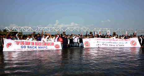
Govt of India pushes unviable hydro projects in North East
Without due process
In a recently held meeting (see the latest updates on this issue from http://www.energylineindia.com/ on this below), the Committee of Secretaries have pushed for large hydro power projects in Arunachal Pradesh. As the agitation against the under construction 2000 MW Subansiri Lower HEP on Arunchal Pradesh border has shown any such move, without credible, independent and comprehensive options assessment, social and environmental impact assessment at project and basin level in a transparent and democratic way would prove to be disastrous not just from social and environment point of view, but also from economic aspects. Hurrying through such projects in the name of establishing prior use rights in the name of Chinese projects in Brahmaputra basin would not be helpful. The fact that the river and its ecology are in use by the people of Arunachal Pradesh, Assam, other North East and east India states, Bhutan and Bangladesh should be sufficient if prior use was indeed a tenable argument in international context.
Some new facts that have come to light from the CoS meet include:
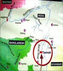
According to the 9th report of the Inter-Ministerial Expert Group (IMEG), discussed during the course of the meeting, there has been an increase of three project sites on the mighty river since IMEG’s last report, prepared a few months earlier. A total of 39 Rune of the River projects/sites are now present on Brahmaputra and its tributaries.
Dam related peripheral infrastructural activity has gathered speed at Lengda, Zhongda and Langzhen, which are on the main course of Siang or Yarlung Tsangpo as it is called in Tibet. The Bome-Medog road which passes through the Great Bend Area is also being upgraded. The Joint Secretary, Ministry of External Affairs said that keeping in mind China’s bad track record to resolve water disputes, he was of the opinion that India should cooperate with other countries facing similar issues with China.
This report suggests that no instance of water diversion activities is discerned on the main course of the river and its tributaries.
Jiacha could be the next hydroelectric project on the mainstream of Brahmaputra River. It may be followed by hydroelectric projects at Lengda, Zhongda, Langzhen, where dam related peripheral infrastructural activity (including 4 new bridges) has gathered speed.
Dagu and Jiexu projects, which are also on the main course of Brahmaputra River, along with Nangxian project may see considerable development activity in future.
The China is carrying out series of cascading ROR projects in the· middle reaches of Brahmaputra, the same may be replicated in the Great Bend Area as a viable alternative to a single mega project and this needs further monitoring.
The CoS has directed the Technical Expert Group (TEG) to submit its action plan for establishing India’s user right within a month’s time. Cabinet Secretary directed TEG to submit a blueprint for action with indicative time lines within a month. CoS has recommended Additional Secretary, Ministry of Power to chair the TEG. Notably, the TEG along with other standing groups like IMEG, will continue to submit their six monthly reports.
Unfortunately, none of the reports of the TEG or IMEG are in public domain, nor are they available under RTI Act. The people of north east are kept in complete darkness about the decisions these officials take.
About the projects in the NE India, the CoS meeting noted:
Special Secretary, Water Resources, stated that 92 HEPs (above 25 MW) with aggregate capacity of 36,272.5 MW have been allotted of which about 20 are at some progressive stage of development.
While for 11 HEPs, aggregate capacity of 8,510 MW, the detail project reports (DPRs) have been submitted to CEA for examination, 9 projects worth 10,570 MW have been concurred by CEA.
In the case of Pashighat (2700MW) project, Techno Economic Clearance has been received and public hearing is scheduled next month.
Indeed as SANDRP analysis of functioning of EAC shows, the Expert Approval Committee has said yes to the largest of projects from Arunachal Pradesh.
An important agenda of the CoS meeting was to assess the progress of the measures suggested by the committee in its 4th meeting held on April 26, 2011. The committee had directed a Joint Steering Committee consisting of representatives from NHPC and Assam government to end the long standing deadlock at the 2,000 MW Subansiri HEP. Notably, the Joint Steering Committee has submitted its report in July 2012. In response to the CoS decision that Ministry of External Affairs (MEA) should firm up views on the modalities of initiating a more informed public debate on the issue of the Brahmaputra water diversion, MEA and MoWR have formed a joint mechanism to pursue the same. An FAQ has also been prepared on the subject to disseminate awareness. Apart from this, MoWR has initiated action on the decision of the CoS to hold informal discussion between concerned ministries for constructing multipurpose projects in Arunachal Pradesh. An inter-ministerial informal discussion was held in October 2011. An outcome of the meeting was that discussion of rehabilitation, an issue hampering many projects, should be project specific. Further, the Planning Commission has formed an Expert Panel to take up the sub-basin wise Environmental Impact Assessment (EIA) study under the chair of Chairman CWC which will submit its report this month.
Many of these actions of CoS and other related bodies clearly lack credibility. The Central Water Commission itself largely acts like a lobby for big dams in India and it is never known to have taken any credible steps for environment or EIA. Under the circumstances, the sub basin wise study that is expected from CWC would not have any credibility.
South Asia Network on Dams, Rivers & People (www.sandrp.in)
This World Water Day comes in year which has been declared as the “International Year of Water Cooperation” by the United National General Assembly. In addition, the UN has proclaimed the decade 2005-2015 as the International Decade for Action, “Water for Life”.
The UN declarations would be welcome if we are able to take credible and effective steps towards water cooperation at every level in an equitable, sustainable way and through local participation. This becomes increasingly relevant when demand for water is increasing due to rising population, urbanisation, industrialisation, increased per capita use and increased losses due to climate change. The available and utilisable supply of water is either stagnant or decreasing due to increased pollution, increased temperatures, changing rainfall pattern, melting of glaciers and over exploitation. Moves towards centralised and undemocratic governance and privatisation of resources are not helpful as they do not promote cooperation, but only further conflicts. The prevailing and emerging situation is a sure fire recipe for increasing conflicts, not cooperation.
At the same time, UN Declaration of July 2010, declaring water as a human right remains only on paper. UN and the governments will clearly need to go beyond mere words and pious declarations.
Water: Some key characteristics Water is not just a commodity for market or an economic good. It is an ecological entity embedded in larger ecology that includes the climate, land, forests, and biodiversity. This includes, but is not limited to: Glaciers, rivers, wetlands, lakes, aquifers, soil, snow and water vapour in the atmosphere. In fact our understanding of the interplay of water in the larger eco-system is still far from complete. When we use water from any source, we should be mindful of its impact in the larger ecosystem. The UN resolution for declaring the 2005-2015 decade was not called “water for life” for nothing. Life here includes not just life of every human being but life on the entire planet.
INDIA AND NEIGHBOURS On this occasion, it would be useful to take a look at the situation in the region. India and China are locked in one-up man ship in Brahmaputra basin, India and Pakistan are competing in destroying shared rivers, ecology and connected livelihoods through hydropower projects in the Indus river basin while India and Bangladesh are struggling to arrive at an agreement on sharing the Teesta waters. When it happens, this will be only the second water sharing treaty, among the 54 rivers shared by India and Bangladesh.
Considering that the countries in this region share the Himalayan watershed on which numerous big and small rivers and millions of people and biodiversity depend, there is an urgent need to have a Regional Policy for the common good of the people of the region.
Possible Chinese diversion The Chinese government officials have often talked about China’s intention of diverting the Brahmaputra (basically Siang River, one of the main tributaries of the Brahmaputra) river to North China, just before the river enters India. China has officially declared its plans to build at least four hydropower projects on the river. The work on the water diversion project is yet to start and China has denied that the project is being taken up. However the Indian government is pushing more big hydro projects in Arunachal Pradesh, claiming that these will help establish India’s prior use rights over the waters of these rivers when China does decide to take up its North South diversion project.
Such a push for big hydro in Arunachal Pradesh under the bogey of Chinese plans is only likely to worsen the situation for the people of Arunachal Pradesh and also for downstream areas in India and Bangladesh. This will only create new water conflicts. Moreover, there is no international mechanism that would help India claim its prior user right. The 1997 UN Convention on the Law of the Non-Navigational Uses of International Watercourses could have been of use, but India has yet to ratify the convention. The best course for India is to push China for a water sharing treaty.
In view of the crisis of climate change, this need has become even more acute. Today, there is no such policy and each country is developing multiple projects on its own, and many of the so-called development projects are actually accelerating climate change impacts and conflicts. Hundreds of hydropower projects are either constructed, are under construction or are being planned across the countries in the region. These projects, along with their paraphernalia of roads, townships, mining, tunnelling, blasting, muck dumping, diverting of rivers and dams are cumulatively having huge, though as yet unquantified impact on the glaciers, forests, aquatic and terrestrial biodiversity, communities, water availability and water supply ,thereby impacting the climate as well.
Flood forecasting: One of the areas where information sharing is immediately required is in the area of sharing information about forecasts related to floods in the shared rivers. The governments in the region seem to have a number of agreements to share information in this regard, including Pakistan-India, Nepal-India, Bhutan-India, Bangladesh-India and China-India. Unfortunately, the shared information in this aspect is not in the public domain. Such shared information must be in public domain. What use is the flood forecasting related information if it is not shared among the people who are going to face the disastrous impacts of floods?
Transparency and Participation in governance in shared river basins There are elaborate, mostly bilateral inter-governmental mechanisms on governance of water and rivers in a number of cases in the South Asia region. These pertain to the bilateral arrangements of India with Pakistan, Bhutan, Bangladesh, Nepal and China. These arrangements include basin level commissions, minister level committees, officer level committees, project specific commissions and so on. Unfortunately, there is practically no transparency in the functioning of these mechanisms, nor is there any role for any concerned actors outside the government. In governance of rivers, waters and related projects, local people have the right to know what is going on in these committees and commissions.
The need for such public participation was acutely felt in the aftermath of the Kosi Disaster on the Indo-Nepal border in August 2008. During the initial period of this disaster, it was shown how the bilateral Kosi High Level committee had failed to achieve the proper maintenance of the embankment that breached with the flow of water in the river was less than 1.5 lakh cusecs (Cubic Feet per Second) even as the design capacity of the embankment was over 9 lakh cusecs. In the days that followed, it became clear that if there had been some non government people on the Indo Nepal Kosi committees and there was more transparency with representation from local communities and civil society in the committees, it would have helped ensure the maintenance of the embankment and that possibly would have saved it from breaching at least on that particular occasion.
Conditions for water cooperation We need to understand key conditions that would help achieve better cooperation in water sector. Some key conditions in this regard include:
Clearly defined priorities for water use, rules of allocation of water to different users, water allocation mechanisms among various sectors, democratic rules of governance of such mechanisms, understanding the importance of ecosystem resources, Conservation of ecosystem resources including Wetlands, forests, rivers, lake, biodiversity; clearly defined and legally enforceable Right to Water and mechanisms to enforce the same. Good governance in this context would include clearly defined norms for key aspects like transparency, accountability and participation. There is need to have legal and institutional set up to achieve these goals.
The weaker sections (tribals, Dalits, women, marginal farmers, coastal and mountain populations) or weaker stakeholders (environment, rivers) have always been losing at the negotiating table. Centralising of authority and decision making being more and more away from local stakeholders creates possibility of more conflicts and conflict resolution becomes more difficult. Local water management can help reduce and also help address conflicts at the local level.
WORLD COMMISSION ON DAMS: Framework for cooperation in water management The report of the World Commission on Dams: Dams and Development – A New Framework for Decision Making provides a useful starting point to achieve cooperation in water management[1]. The recommendations of the report are applicable at every level, from community to international level. It would be good if the United Nations recognises the principles in the WCD report in this year of water cooperation and provides some institutional support for their implementation and if countries in the region follow these recommendations for transboundary as well as local rivers.
THE ROLE OF UN Sixty percent of the world’s freshwaters are transboundary. So there should be little doubt that water cooperation is critical to avoid conflicts and ensure effective and sustainable use of shared resources. Over the years, the UN has been coming out with various programs and principles on water resources management. However, none of them have legal and institutional back up. Its 1997 Convention on the Law of the Non-Navigational Uses of International Watercourses is yet to come into force[2] as it has yet to receive ratification of the required 35 countries. Significantly, India abstained from voting for the convention at the UN and also has yet to ratify it.
Another instrument in this context is the UNECE (UN Economic Commission for Europe) Convention on the Protection and Use of Transboundary Watercourses and International Lakes (Water Convention)[3] is currently the only international legal framework in force governing the management of transboundary water resources. It turned into a global convention in Feb 2013, having received sufficient number of ratifications. The UNECE website says in this regard: “This is a ground-breaking development as the Convention was originally negotiated as a regional instrument by countries of the United Nations Economic Commission for Europe. It is also a major milestone of the International Year of Water Cooperation celebrated in 2013… more than 30 countries from outside the UNECE region already actively participate in activities under the Convention. Several countries have already indicated their interest in becoming Parties… will create a strong legal base for present and future Parties to the Convention to join their forces to protect transboundary waters and the benefits deriving from them… Moreover it will strengthen political support to transboundary water cooperation.”
At the same time UN needs to ensure that it does not become cause of greater conflicts as is happening now through its funding of destructive hydropower and other projects under the UNFCCC’s Clean Development Mechanism. Those projects are happening at the cost of the local communities and their environment and providing completely unjustified, unwarranted and unnecessary funding of project developers, thus fattening the bank balances of the rich and at the same time creating more conflicts.
The world leaders and media have been quoting ad nauseam the now infamous quote from the former United Nations Secretary General Boutros Boutros Ghali to the effect that next war may be fought for water. Many would call this unwarranted war mongering, that too from a UN personnel. There is a lot the UN needs to do to achieve greater water cooperation across the world to wash off this image. May the UN succeed in this effort!
South Asia Network on Dams, Rivers & People (www.sandrp.in)
[1] It calls for going “beyond looking at water as a finite commodity to be divided and embrace an approach that equitably allocates not the water, but the benefits that can be derived from it”, for agreements based on principles of equitable and reasonable utilisation, no significant harm, prior information, free prior and informed consent of affected communities. The report says that “Storages and diversion of water on transboundary rivers has been a source of considerable tension between countries and within countries.” Some key strategic priorities of the report include: gaining public acceptance, recognising entitlements, sustaining rivers and livelihoods.