Dam Induced Flood Disaster · Himachal Pradesh · Himalayas · Hydropower · Uttarakhand

Uttarakhand flood disaster of June 2013: Lest we forget the experience and its lessons

June 16, 2014 This is a sad day, reminding us of the Uttarakhand disaster that began on this day a year ago. The disaster was triggered by unseasonal and heavy rainfall in which indicates a clear footprint of climate change. At the same time, the role played by massive infrastructure interventions, including an onslaught of hydropower projects and dams in Uttarakhand’s fragile ecosystem, in magnifying the proportions of this disaster manifold is also undeniable[1]. It is a sign of callousness of our system that till date we do not have a comprehensive report about this disaster that throws light on what all actually happened, which institutes played what role, which institutes failed or succeeded in their assigned role, what were the rehabilitation and resettlement provisions, processes, plans and policies, and what lessons we can learn from this experience.

The lessons from this experience hold significance for the entire Himalayan region.

Uttarakhand and the union government declined to even investigate the role of hydropower projects in the disaster. It was left to the Supreme Court of India, through its order of Aug 13, 2013, to ask the government to set up a committee to assess the role of existing and under construction hydropower projects in the disaster.[2] The apex court also asked governments to stop clearances to all such projects in the state in the meantime. The reluctant Union Ministry of Environment and Forests (MEF) took two more months to set up the committee which was headed by Dr Ravi Chopra.[3]The committee submitted the report in mid April, 2014, but two months later the MEF is yet to put up the report in public domain. Or make it available to the people of Uttarakhand in their language or invite their views. SANDRP had written in detail about the recommendations of the EB, the committee certainly said that the hydropower projects played a significant role in the disaster[4]. Eminent geologist Prof K S Valdiya has also written in Current Science in May 2014 (Vol. 106, p 1-13) that most projects are being built in landslide prone, seismically active area and should not be built there.

It was again left to the Supreme Court on May 7, 2014 to order stoppage of work on the 24 hydropower projects. The Expert Body recommended cancellation for 23 of these projects and change of parameters for one project. There is immense hope in further proceedings in the apex court in coming months, since the results will provide a guide for the whole Himalayan region in Uttarakhand, in other states in India and even for the Himalayan region beyond the border.

At the same time, it is unfortunate to see that the MEF, the Union government and Uttarakhand government seem to have learnt no lessons from the disaster. These bodies have been trying all sorts of manipulations to push massive projects like Lakhwar and Vyasi in Yamuna basin even without Environment Impact Assessment, Cumulative Impact Assessment or public consultations.

Now a new government has taken over at the centre. It is possible sign of things to come that India’s new Prime Minister Shri Narendra Modi has chosen this anniversary day to lay foundation stone for a huge hydropower project in the Himalayan region, read his own statement dated June 14, 2014[1], about his impending trip to Bhutan on June 15-16, 2014: “During the visit, we will lay the Foundation Stone of the 600 MW Kholongchu Hydropower Project[5].” This possibly indicates the thinking of new government on this issue.

Picture1

The memory and lessons of this unprecedented disaster seem to be fading already. While going through the articles on this disaster in a number of newspapers like Indian Express, Hindu, Tribune, Business Standard, among others, I could find just one article in Business Standard[2] that mentioned the role of hydropower projects in Uttarakhand disaster.

gangani1

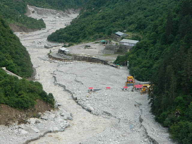
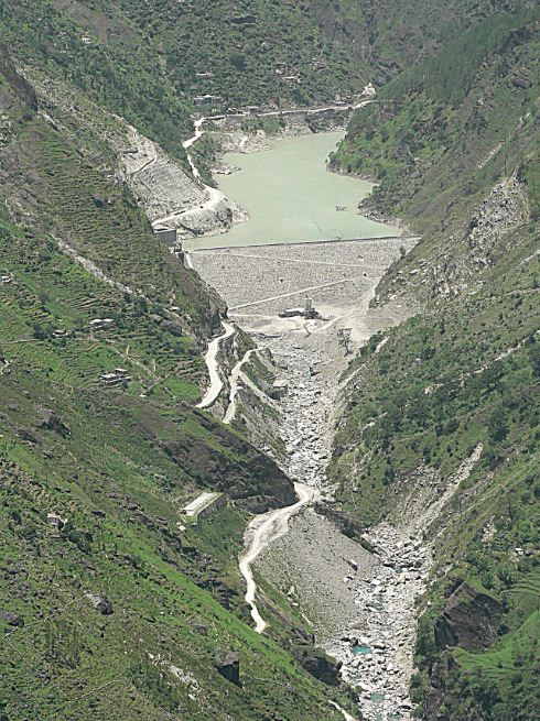
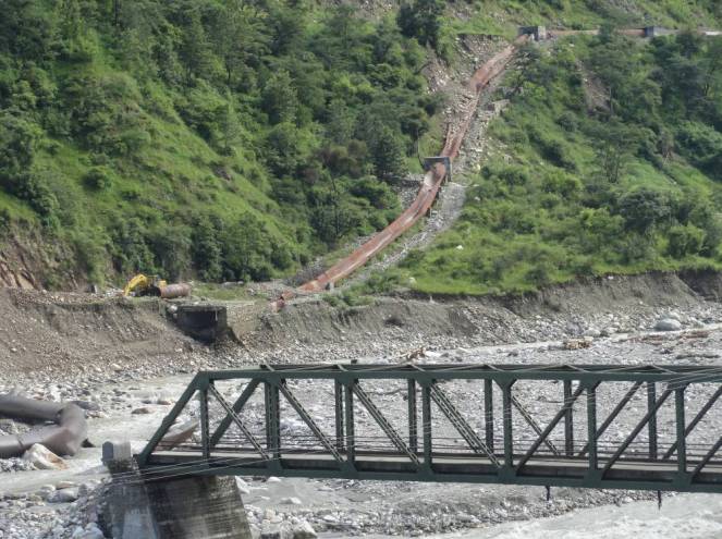
It is very important, in this context to remember the issue. We are here presenting here some photos of the damaged hydropower projects of Uttarakhand in that context. The photos are mostly taken from official sources, namely 582 page annexures to the Ravi Chopra Committee report. Most of the photos have not been in public domain to the best of our information.

Assi Ganga I (4.5 MW in Uttarkashi district): Letter from Regional office of MoEF to Uttarakhand Forest secretary dated 30 March, 2014 says:“The project was heavily damaged in 2013 devastation.” It also says that the project is in Ganga Eco Sensitive Zone and in the zone only projects below 2 MW capacity and serving the needs for the local population are allowed. Hence it says, “…the project should not start without obtaining fresh forest clearance and permission from the Central Govt.”

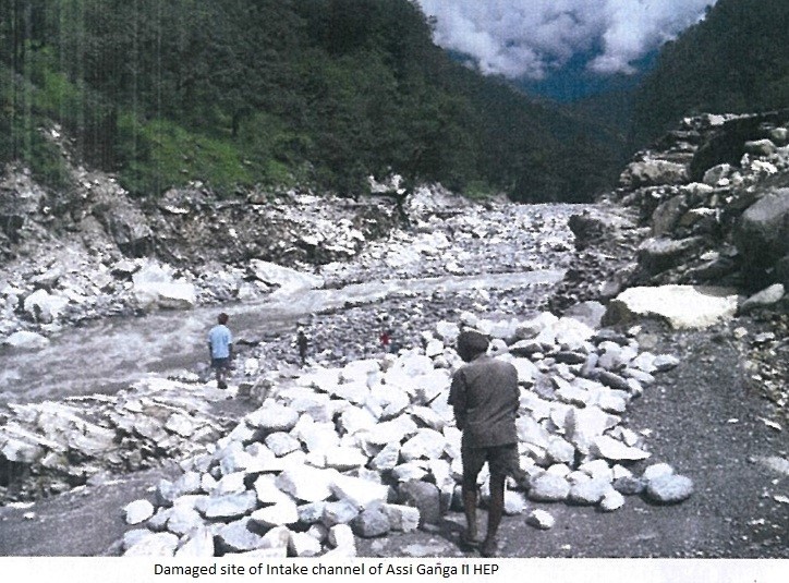
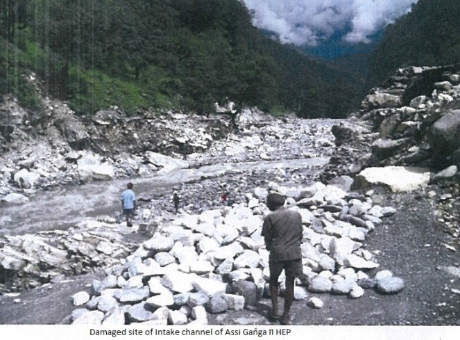
Assi Ganga II (4.5 MW in Uttarkashi district): Similar letter from Regional office of MoEF says: “The project was heavily damaged in 2013 devastation.” Following photos from the monitoring report of the project speak about the damage this project suffered:
AssiGangaII

2AssiGangaKaldigarh HEP (9 MW in Uttarkashi district) The project heavily damaged in 2012 floods and it being in Eco Sensistive zone, the report says the project should not be allowed to restart without permission from central govt.

Kotli Bhel 1A HEP (195 MW on Bhagirathi river in Uttarkashi district) The project has not given the final forest clearance. The stage I forest clearance was given on 13.10.2011 and environment clearance on 09.05.2007. The Ravi Chopra Committee report has asked for changes in the project parameters and Supreme Court order of May 7, 2014 has asked for stoppage of work on 24 HEPs, this project is on that list of 24 projects. The regional office report says that work on the project has been started on non forest land, which should now come to stop.

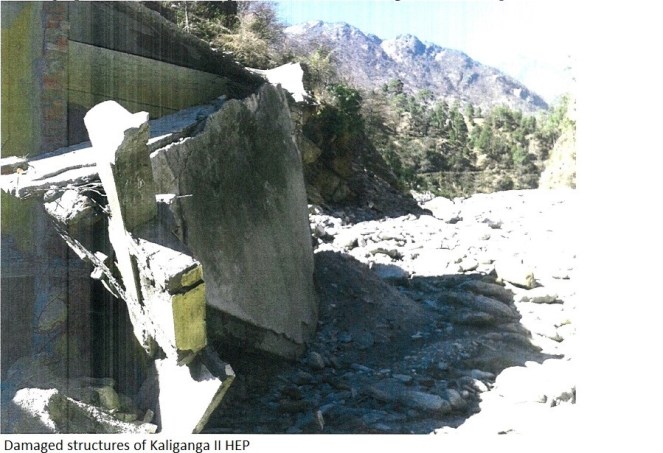
Kaliganga II HEP (6 MW, Rudraprayag district, Mandakini Basin) The Project got forest clearance on March 6, 2007. But project is yet to provide non forest land as required under act. The project is also within 2 km of Kedarnath Wildlife Sanctuary, but has not got clearance either from state wildlife Board or National Wildlife Board. The project construction thus is clearly illegal. Project has now suffered damages in June 2013 disaster, as can be seen from the photos below.

KaligangaII

2KaliGnaga

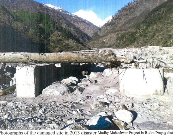
Madhya Maheshwar HEP (10 MW, Rudra Prayag district):
MadhyaMaheshwar

Phata Byung HEP (76 MW, Mandakini river, Rudra Prayag district):
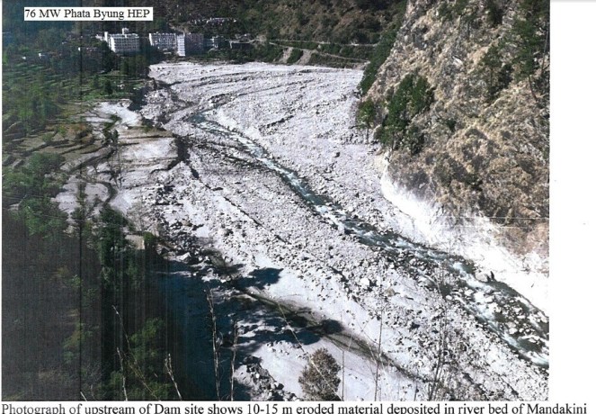
PhataBuyung

Singoli Bhatwari HEP (99 MW, Mandakini river, Rudra Prayag district):
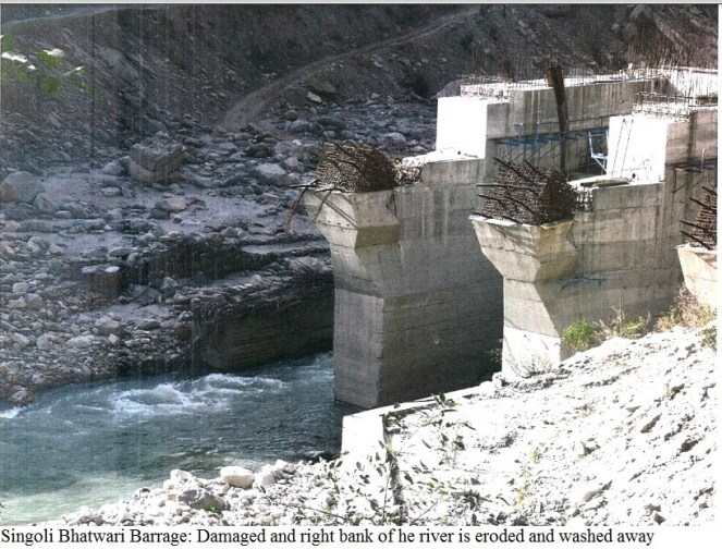
SingoliBhatwari

Bhyunder Ganga HEP (15 MW, Alaknanda river, Chamoli Disrict):

BhuynderGanga

Lata Taopan HEP (171 MW, Chamoli district):

Lata Tapovan

Tapovan Vishnugad HEP (520 MW, Chamoli district):
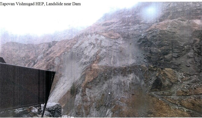
TapovanVIshnugad

Kali Ganga I HEP (4 MW, Rudraprayag District):

KaliGangaI

Banala Mini HEP (15 MW, Chamoli Dist):

BanalaMiniHEP

 CONCLUSION: We hope this would possibly remind us that Himalayas cannot take the hydro onslaught that is happening now.

What happened in Uttarakhand a year ago in June 2014 was possibly a warning.

These photos are a reminder that even the hydropower projects are not safe and they will invite not only destruction for themselves, but also for the surrounding areas. Lest we forget the warning.

-Himanshu Thakkar (ht.sandrp@gmail.com)

References:

[1] https://sandrp.wordpress.com/2013/06/21/uttarakhand-deluge-how-human-actions-and-neglect-converted-a-natural-phenomenon-into-a-massive-disaster/

[2] https://sandrp.wordpress.com/2013/10/20/expert-committee-following-sc-order-of-13-aug-13-on-uttarakhand-needs-full-mandate-and-trimming-down/

[3] https://sandrp.wordpress.com/2014/04/29/report-of-expert-committee-on-uttarakhand-flood-disaster-role-of-heps-welcome-recommendations/

[4] https://sandrp.wordpress.com/2014/04/29/report-of-expert-committee-on-uttarakhand-flood-disaster-role-of-heps-welcome-recommendations/

[5] http://timesofindia.indiatimes.com/india/Modi-woos-Thimphu-ahead-of-Bhutan-China-dialogue/articleshow/36623685.cms

End Notes:

[1] PIB statement of June  14, 2014, see: http://pib.nic.in/newsite/erelease.aspx

[2] http://www.business-standard.com/article/economy-policy/the-mountain-s-not-a-molehill-114061400858_1.html

Himalayas · Hydropower

Himalayas cannot take this Hydro onslaught

MESSAGE ON WORLD ENVIRONMENT DAY 2014:

SAVE HIMALAYAS FROM THIS HYDRO ONSLAUGHT!

It is close to a year after the worst ever Himalayan flood disaster that Uttarakhand or possibly the entire Indian Himalayas experienced in June 2013[1]. While there is no doubt that the trigger for this disaster was the untimely and unseasonal rain, the way in which this rain translated  into a massive disaster had a lot to do with how we have been treating the Himalayas in recent years and today. It’s a pity that we still do not have a comprehensive report of this biggest tragedy to tell us what happened during this period, who played what role and what lessons we can learn from this experience.

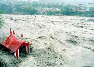
Floods in Uttarakhand Courtesy: Times of India

One of the relatively positive steps in the aftermath of the disaster came from the Supreme Court of India, when on Aug 13, 2013, a bench of the apex court directed Union Ministry of Environment and Forests (MoEF)[2] to set up a committee to investigate into the role of under-construction and completed hydropower projects. One would have expected our regulatory system to automatically initiate such investigations, which alas is not the case. Knowing this, some us wrote to MoEF on July 20, 2013[3], to exactly do such an investigation, but again MoEF played deaf and blind to such letters.

The SC mandated committee was set up through an MoEF order dated Oct 16 2013[4] and MoEF submitted the report on April 16, 2014.

5 MW Motigad Project in Pithorgarh District destroyed by the floods. Photo: Emmanuel Theophilus, Himal Prakriti

The committee report, signed by 11 members[5], makes it clear that construction and operation of hydropower projects played a significant role in the disaster. The committee has made detailed recommendations, which includes recommendation to drop at least 23 hydropower projects, to change parameters of some others. The committee also recommended how the post disaster rehabilitation should happen, today we have no policy or regulation about it. While the Supreme Court of India is looking into the recommendations of the committee, the MoEF, instead of setting up a credible body to ensure timely and proper implementation of recommendations of the committee has asked the Court to appoint another committee on the flimsy ground that CWC-CEA have submitted a separate report advocating more hydropower projects! The functioning of the MoEF continues to strengthen the impression that it is working like a lobby for projects rather than an independent environmental regulator. We hope the apex court see through this.

Boulders devouring the Vishnuprayag Project. 26th June 2013 Photo: Matu jan Sangathan

Let us turn our attention to hydropower projects in Himalayas[6]. Indian Himalayas (Himachal Pradesh, Uttarakhand[7], Jammu & Kashmir, Sikkim, Arunachal Pradesh and rest of North East) already has operating large hydropower capacity of 17561 MW. This capacity has leaped by 68% in last decade, the growth rate of National Hydro capacity was much lower at 40%. If you look at Central Electricity Authority’s (CEA is Government of India’s premier technical organisation in power sector) list of under construction hydropower projects in India, you will find that 90% of projects and 95% of under construction capacity is from the Himalayan region. Already 14210 MW hydropower capacity is under construction. In fact CEA has now planned to add unbelievable 65000 MW capacity in 10 years (2017 to 2027) between 13th and 14th Five Year Plans.

Meanwhile, the Expert Appraisal Committee of Union Ministry of Environment and Forests on River Valley Projects has been clearing projects at a break-neck speed with almost zero rejection rate. Between April 2007 and Dec 2013[8], this committee recommended final environment clearance to 18030.5 MW capacity, most of which has not entered the implementation stage. Moreover, this committee has recommended 1st stage Environment clearance (what is technically called Terms of Reference Clearance) for a capacity of unimaginable 57702 MW in the same period. This is indicative of the onslaught of hydropower projects which we are likely to see in the coming years. Here again an overwhelming majority of these cleared projects are in Himalayan region.

Agitation Against Lower Subansiri Dam in Assam Source: SANDRP
Agitation Against Lower Subansiri Dam in Assam
Source: SANDRP

What does all this mean for the Himalayas, the people, the rivers, the forests, the biodiversity rich area? We have not even fully studied the biodiversity of the area. The Himalayas is also very landslide prone, flood prone, geologically fragile and seismically active area. It is also the water tower of much of India (& Asia). We could be putting that water security also at risk, increasing the flood risks for the plains. The Uttarakhand disaster and changing climate have added new unknowns to this equation.

We all know how poor are our project-specific and river basin-wise cumulative social and environmental impact assessments. We know how compromised and flawed our appraisals and regulations are. We know how non-existent is our compliance system. The increasing judicial interventions are indicators of these failures. But court orders cannot replace institutions or make our governance more democratic or accountable. The polity needs to fundamentally change, and we are still far away from that change.

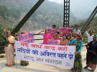
Peoples protests against Large dams on Ganga. Photo: Matu Jansangathan

The government that is likely to take over post 2014 parliamentary elections has an opportunity to start afresh, but available indicators do not provide such hope. While UPA’s failure is visible in what happened before, during and after the Uttarakhand disaster, the main political opposition that is predicted to take over has not shown any different approach. In fact NDA’s prime ministerial candidate has said that North East India is the heaven for hydropower development. He seems to have no idea about the brewing anger over such projects in Assam and other North Eastern states. That anger is manifest most clearly in the fact that India’s largest capacity under-construction hydropower project, namely the 2000 MW Lower Subansiri HEP has remained stalled for the last 29 months after spending over Rs 5000 crores. The NDA’s PM candidate also has Inter Linking of Rivers (ILR) on agenda. Perhaps we have forgotten as to why the NDA lost the 2004 Parliamentary elections.  The arrogant and mindless pursuit of projects like ILR and launching of 50 000 MW hydropower campaign by the then NDA government had played a role in sowing the seeds of people’s anger with that government.

In this context we also need to understand what benefits these hydropower projects are actually providing, as against what the promises and propaganda are telling us. In fact our analysis shows that the benefits are far below the claims and impacts and costs are far higher than the projections. The disaster shows that hydropower projects are also at huge risk in these regions. Due to the June 2013 flood disaster large no of hydropower projects were damaged and generation from the large hydro projects alone dropped by 3730 million units. In monetary terms this would mean just the generation loss at Rs 1119 crores assuming conservative tariff of Rs 3 per unit. The loss in subsequent year and from small hydro would be additional.

It is nobody’s case that no hydropower projects be built in Himalayas or that no roads, townships, tourism and other infrastructure be built in the Himalayan states. But we need to study the impact of these massive interventions (along with all other available options in a participatory way) in what is already a hugely vulnerable area, made worse by what we have done so far in these regions and what climate change is threatening to unleash. In such a situation, such onslaught of hydropower projects on Himalayas is likely to be an invitation to even greater disasters across the Himalayas. Himalayas cannot sustain this onslaught.

It is in this context, that the ongoing Supreme Court case on Uttarakhand provides a glimmer of hope. It is not just hydropower projects or other infrastructure projects in Uttarakhand, or for that matter in other Himalayan states that will need to take guidance from the outcome of this case, but it could provide guidance for all kinds of interventions all across Indian Himalayas. Our Himalayan neighbors can also learn from this process. Let us end on that hopeful note here!

Himanshu Thakkar (ht.sandrp@gmail.com)

END NOTES:

[1] For SANDRP blogs on Uttarakhand disaster of June 2013, see: https://sandrp.wordpress.com/?s=Uttarakhand

[2] For details of Supreme Court order, see: https://sandrp.wordpress.com/2013/08/14/uttarakhand-flood-disaster-supreme-courts-directions-on-uttarakhand-hydropower-projects/

[3] https://sandrp.wordpress.com/2013/07/20/uttarakhand-disaster-moef-should-suspect-clearances-to-hydropower-projects-and-institute-enquiry-in-the-role-of-heps/

[4] For Details of MoEF order, see: https://sandrp.wordpress.com/2013/10/20/expert-committee-following-sc-order-of-13-aug-13-on-uttarakhand-needs-full-mandate-and-trimming-down/

[5] https://sandrp.wordpress.com/2014/04/29/report-of-expert-committee-on-uttarakhand-flood-disaster-role-of-heps-welcome-recommendations/

[6] https://sandrp.wordpress.com/2014/05/06/massive-hydropower-capacity-being-developed-by-india-himalayas-cannot-take-this-onslought/

[7] https://sandrp.wordpress.com/2013/07/10/uttarakhand-existing-under-construction-and-proposed-hydropower-projects-how-do-they-add-to-the-disaster-potential-in-uttarakhand/

[8] For details of projects cleared during April 2007 to Dec 2012, see: https://sandrp.in/env_governance/TOR_and_EC_Clearance_status_all_India_Overview_Feb2013.pdf and https://sandrp.in/env_governance/EAC_meetings_Decisions_All_India_Apr_2007_to_Dec_2012.pdf

[9] An edited version of this published in June 2014 issue of CIVIL SOCIETY: http://www.civilsocietyonline.com/pages/Details.aspx?551

Himalayas · Hydropower · Hydropower Performance

Massive Hydropower capacity being developed by India: Himalayas cannot take this onslaught

At least 49 large[1] hydropower projects are under construction in India today, with a cumulative capacity of 15006 MW[2]. As per the latest bulletin from Central Electricity Authority[3], “Status of Hydro Electric Projects under Execution for 12th Plan & beyond (Excluding projects above[4] 25 MW)” dated March 31, 2014, 35 of these projects (9934 MW) are expected to be commissioned in 12th Five Year Plan[5] and remaining 14 with installed capacity of 5072 MW would provide benefit beyond 12th Plan.

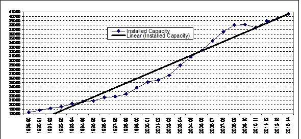
Considering that 1534 MW capacity has already been added in first two years of ongoing 12th Five Year Plan (during 2012-13 and 2013-14), CEA projections means that India hopes to add massive 11468 MW capacity during the current five year plan. This will be higher than capacity added in any other five year plan and 254% of the capacity addition during the last, 11th Five Year Plan (2007-12) when India added 4514 MW. The graph below shows how steeply our hydropower installed capacity is going up over the last 25 years.


Rapidly Increasing installed capacity of Large Hydropower Projects in India

The proponent of even more accelerated hydro capacity addition misleadingly talk about the need for having 40% of installed grid capacity as hydro.

In line with this, the CEA came out with plans to add 65000 MW in 13th Five Year Plan (2017-2022: 30 000 MW) and 14th Five Year Plan (2022-2027: 35 000 MW). (see http://www.energylineindia.com/ of May 6, 2014)

There is no science behind this  advocacy. It is basically a suggestion possibly based on the general assumption that peaking demand is 40% higher than base-load demand. Hence if we have 40% installed capacity from hydro in the grid, this can take care of total demand optimally. However, this is based on assumption that hydro capacity is indeed used for peaking. This assumption is completely wrong in India, with no agency monitoring or even reporting how much of the hydro generation currently provide peaking power. Without such optimum use of current hydro capacity, where is the case for 60:40 grid capacity ratio for hydro? It goes without saying that when hydro projects are used for peaking power, there are additional social and  environmental impacts in the downstream and upstream. These need to assessed and those who suffer are compensated.

On similar lines, one can answer the advocacy for claim that hydro is clean, green, renewable and cheap source of power or that  run of the river or small hydropower projects are more environmentally benign. However, this blog is not attempting to answer all such fallacies here, it needs a separate blog.

While this is happening, the Expert Appraisal Committee of Union Ministry of Environment and Forests on River Valley Projects has been clearing projects at break a neck speed with almost zero rejection rate. Between April 2007 and Dec 2013, this committee recommended environment clearance to 18030.5 MW capacity, most of which has not entered the implementation stage. Moreover, this committee has recommended 1st Environment clearance (what is technically called Terms of Reference Clearance) for a capacity of unimaginable 57702 MW in the same period. This is indicative of the onslaught of hydropower projects which we are likely to see in the coming years.

Figure 1 TORs (First Stage EC) and EC recommended by EAC between April 2007 - December 2013
Figure 1 TORs (First Stage EC) and EC recommended by EAC between April 2007 – December 2013

 Table: Sector-wise & plan-wise number of & capacity of under construction HEPs

Sector

During 12th FYP

After 12th Plan

Total

No of Projects Installed capacity, MW No of Projects Installed capacity, MW No of Projects Installed capacity, MW
Central

11[6]

5312 3 2615 14

7927

State

12

1506 3 736 15

2242

Pvt

12

3116 8 1721 20

4837

Total

35

9934 14 5072 49

15006

Among the three sectors, the largest number of under construction projects (20) are from private sector. However, among all sectors of under construction projects, central sector projects have the highest installed capacity (7927 or 53% of under construction capacity of 15006 MW).

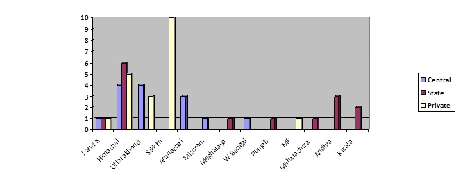
Figure 2 Sectorwise ownership of under-construction HEPs in Numbers

Vulnerable Himalayas are the target In the second table the state-wise and sector-wise break of numbers and capacity of under construction HEPs has been given. Himachal Pradesh has the highest number and highest installed capacity projects among all states. That state also has the highest installed capacity (8139 MW or over a fifth of operating HEP capacity at national level) of large operating hydropower projects. Sikkim, however, has the highest number and capacity of private sector hydropower projects under construction. In fact, half of the total national-level private sector projects which are under construction are in that tiny state. Their installed capacity is more than half the installed capacity of all the private sector hydropower projects under construction at national level. Ironically, the state also has the highest biodiversity in the country.

Figure 3 Installed Capacity of under construction HEPs, sector-wise ownership, in MW

Himachal Pradesh and Uttarakhand also have 5 and 3 private sector HEPs under construction respectively. The 5 Himalayan states of Jammu & Kashmir (J&K), Himachal Pradesh, Uttarakhand, Sikkim and Arunachal Pradesh between them have 38 of the 49 under construction hydropower projects with total capacity of 13550 MW or over 90% of under construction capacity. In addition, the projects of Mizoram, Meghalaya, W Bengal (Teesta L Dam IV) and Punjab (Shahpur Kandi on Ravi River) are also in Himalayan zone.

Table: State-wise & sector-wise number and capacity of under-construction HEPs

State

Central Sector

State Sector Private Sector

Total

No of projects Installed Capacity, MW No of projects Installed Capacity, MW No of projects Installed Capacity, MW No of projects Installed Capacity, MW
J&K

1

330 1 450 1 850 3

1630

Himachal P

4

2532 6 956 5 460 15

3948

Uttarakhand

4

2135 – – 3 505 7

2640

Sikkim

–

– – – 10 2622 10

2622

Arunachal P

3

2710 – – – – 3

2710

Mizoram

1

60 – – – – 1

60

Meghalaya

–

– 1 40 – – 1

40

W Bengal

1

160 – – – – 1

160

Punjab

–

– 1 206 – – 1

206

Madhya Pr

–

– – – 1 400 1

400

Maharashtra

–

– 1 80 – – 1

80

Andhra Pr

–

– 3 410 – – 3

410

Kerala

–

– 2 100 – – 2

100

Total

14

7927 15 2242 20 4837 49

15006


Figure 4 State-wise and sector-wise number of HEPs under construction
Figure 5 State-wise installed capacity of under construciotn HEPs

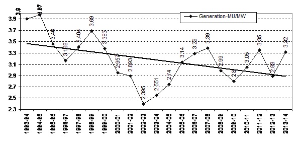
Diminishing Returns This blind rush for hydropower projects (which have serious and irreversible impacts on social and ecological systems) is difficult to understand and justify considering their poor generation performance, rising costs and availability of better options. To illustrate, in the graph below we can see how power generation per unit (MW) installed capacity has been steadily reducing over the last two decades. From 1993-94 to the latest year of 2013-14, there has been a huge drop of 16.5%.

Diminishing power generation from India's Hydropower Projects over the last two decades
Diminishing power generation from India’s Hydropower Projects over the last two decades

Yawning gap between promised and actual generation of Hydro Projects Another way to look at performance of hydropower projects would be to compare the projected (as promised in Techno Economic Clearance) and actual generation (both at 90% dependability) of electricity by HEPs. This assessment shows that about 89% of India’s operating hydropower projects are generating at below the promised levels. Shockingly, half of under performing projects are generating at below 50% of promised generation levels.

How much Peaking Power are we generating? A third way to assess the hydropower generation is in terms of peaking power, a USP[7] of hydropower projects. However, no figures are available as to how much of the generation from hydropower projects are happening during peaking hours. No agency in India is even monitoring this or reporting this: including CEA, Central or State Electricity Regulatory Authority, National, Regional or State Load Dispatch Centers, Union or state Power Ministries or individual operators. In short, there is no case for justifying more hydro in the name of providing peaking power if we are neither monitoring nor optimizing hydropower generation during peaking hours. One expected CEA to do this job, but it seems they are busy lobbying for hydropower projects rather than functioning as India’s premier Technical Power sector agency.

Invitation to disaster? The consequences of such massive capacity addition are and will continue to be disastrous for the rivers, forests, biodiversity and people. The Uttarakhand disaster of June 2013 has shown the vulnerability of hydropower projects in Himalayas, as well as their impacts. The disaster and independent reports[8] also show how the construction and operation of these projects have contributed to compounding the proportion of the disaster. Climate Change is accentuating this situation and will continue to do so with increasing intensity as per the IPCC reports.

Role  of HEPs in Uttarakhand disaster: CEA and CWC in denial mode This analysis of under construction hydropower projects as reported in the latest CEA bulletin shows that Himalayas is the target for overwhelming majority of hydropower projects being taken up India (& neighbouring countries like Bhutan, Nepal, Pakistan and Tibet). The Uttarakhand disaster showed how hydropower projects are increasing the existing vulnerabilities and disaster potential of the Himalayan region in times of natural calamities. An independent committee appointed by MoEF following Supreme Court orders of Aug 13, 2013 pointed out the role of hydropower projects in Uttarakhad disaster of June 2013.

It should be highlighted here that multiple hydropower projects should invite cumulative impact assessment. As Supreme Court order of Aug 13, 2013 highlighted, such cumulative impact assessment need to be done in a credible way and not the way AHEC of IITR did for the Bhagirathi-Alaknanda basin.

Strangely, instead of accepting this reality and taking this into account in decision making processes, Central Water Commission and Central Electricity Authority are in a denial mode! They collectively submitted a completely unscientific and unfounded report to Union Environment & Forests Ministry, advocating for hydropower projects rather than assessing their role in disaster, which was the mandate given by Supreme Court of India to MoEF. The CEA is clearly jeopardizing whatever credibility it has in joining hands with CWC. It would be better for both the agencies to accept and wake up to these realities.

Else, such onslaught of hydropower projects on Himalayas is likely to be an invitation to further disasters all across the Himalayas. All our decision makers and all others concerned need to take note of this urgently.

Himanshu Thakkar (ht.sandrp@gmail.com)

END NOTES:

[1] Defined as those projects having installed capacity above 25 MW

[2] In reality, there are many other large HEPs under construction, but his figure is based on CEA.

[3] http://cea.nic.in/reports/proj_mon/status_he_execution.pdf, CEA has been pretty irregular in putting up these bulletins, after Nov 2013, the next bulletin was available only now.

[4] In reality, this should be “below”, we have italicized the word since the error is in the original.

[5] Ending on March 31, 2017

[6] CEA projects that out of 2000 MW installed capacity of Lower Subansiri HEP in Arunachal Pradesh, 1000 MW will be commissioned in 12th Plan and the rest of 1000 MW thereafter.

[7] Unique Selling Proposition

[8] https://sandrp.wordpress.com/2014/04/29/report-of-expert-committee-on-uttarakhand-flood-disaster-role-of-heps-welcome-recommendations/

Dams, Rivers & People

Dams, Rivers & People – December 2013-January 2014, Vol 11, Issue 11-12

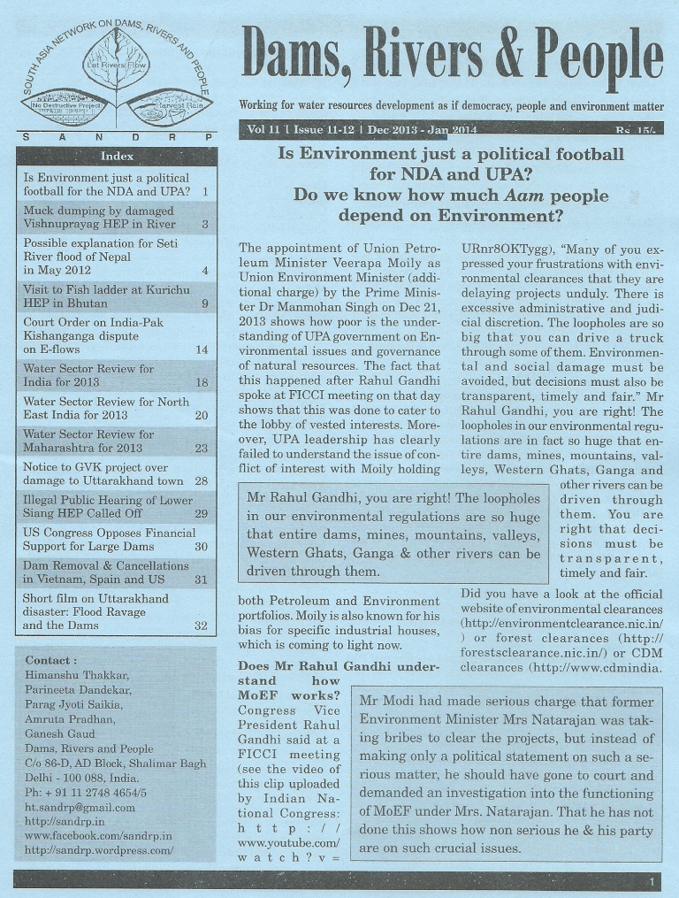
The December 2013 – January 2014 edition of SANDRP’s magazine ‘Dams, River and People’ is now available online. This is the 11-12th issue of magazine in its 11th volume.  The contents magazine are mentioned in the list below. Packed with information on water, rivers, dams and environment, this issue covers matters at home in India as well in Bhutan, Nepal, Spain, Vietnam, United States of America and water dispute between India and Pakistan. The  magazine in pdf format is available here — https://sandrp.in/DRP_Dec_2013_Jan_2014.pdf. Several of the articles are also available in SANDRP’s blog and they can be viewed just by clicking on the name in the list. Enjoy reading.

DRP_issue_11_12_cover0001

Contents

Page No
Is Environment just a political football for the NDA and UPA?   1
Muck dumping by damaged Vishnuprayag HEP in River 3
Possible explanation for Seti River flood of Nepal in May 2012 4
Visit to Fish ladder at Kurichu HEP in Bhutan 9
Court Order on India-Pak Kishanganga dispute on E-flows 14
Water Sector Review for India for 2013 18
Water Sector Review for North East India for 2013 20
Water Sector Review for Maharashtra for 2013 23
Notice to GVK project over damage to Uttarakhand town 28
Illegal Public Hearing of Lower Siang HEP Called Off 29
US Congress Opposes Financial Support for Large Dams 30
Dam Removal & Cancellations in Vietnam, Spain and US 31
Short film on Uttarakhand disaster: Flood Ravage and the Dams 32
Dams

A review of the water sector in India in 2013: Increasing signs of crisis

Year-end provides a wonderful opportunity for us to take stock of siatuations. If we look at India’s water sector, the above-average rainfall in 2013 monsoon would mean good agricultural production.

But the water sector as a whole is showing increasing signs of trouble.

Let us take few examples. The most striking crisis of 2013 was the unprecedented flood disaster in Uttarakhand in June where thousands perished. Experts and media called it a man-made disaster with a significant role played by existing and under construction hydropower projects and other unsustainable infrastructure. (SANDRPs Report) The Supreme Court order of Aug 13, 2013 directed the Union Ministry of Environment and Forests to set up a committee to look into the role played by existing and under construction hydropower projects in the disaster and also directed that no further clearance to any hydropower projects be given till further orders. This order was possibly the only hopeful sign since Uttarakhand government, other Himalayan states or the central agencies including NDMA and MoEF, seem to have learnt no lessons from the disaster.

Destroyed Vishnuprayag HEP on Alaknanda . Courtesy: Matu Jan Sangathan

Earlier in 2012-13 we saw triple crisis in Maharashtra in the form of worst drought in 40 years, worst irrigation scam in independent India and agitation against diversion of huge quantity of water from agriculture to non agriculture sector without any participatory process. In Andhra Pradesh too, a massive irrigation scam was exposed by the CAG report. In fact inequity in the distribution of costs and benefits related to water sector project lies at the heart of the bifurcation of the troubled state.

 Dry Seena River in Madha in March 2013. Madha has a dense concentration of Sugar Factories. Photo: SANDRP
Dry Seena River in Madha in March 2013. Madha has a dense concentration of Sugar Factories. Photo: SANDRP

In Chhattisgarh and downstream Orissa, thermal power plans of massive capacities are going to impact the water situation so fundamentally that big trouble is likely to erupt there, which may impact several other sectors. Madhya Pradesh government is on a big dam building spree in all its river basins, including Narmada, Chambal and also the water scarce Bundelkhand. All of these projects are for canal irrigation when canal irrigation has failed to add any area to the total net irrigation at national level for over two decades now. We could see a new massive irrigation scam in MP in coming years, in addition to agitations and interstate disputes. Gujarat too saw a very bad drought in 2012-13, and there is increasing perception that Gujarat government is by design not building the distribution network to take the Narmada Dam waters to Kutch and Saurashtra, for whom the project was justified and built.

In North East India it is now two years since massive agitation has led to stoppage of work at ongoing 2000 MW Lower Subansiri hydropower project. This is India’s largest under construction hydropower project on which over Rs 5000 crores have been spent without putting in place basic studies or participatory decision making process. Similar fate awaits if the government goes ahead with other hydropower development projects in the region without learning lessons from this episode. During the year, Forest Advisory Committee’s rejection to grant forest clearance to 3000 MW Dibang and 1500 MW Tipaimukh projects in the region was a good sign, so is the stoppage of work at Maphithel dam in Manipur by the National Green Tribunal.

Breathtaking floodplains of the Lohit River, an important tributary of the Brahmaputra, threatened by the 1750 MW Lower Demwe Dam.  Photo: Neeraj Vagholikar
Breathtaking floodplains of the Lohit River, an important tributary of the Brahmaputra, threatened by the 1750 MW Lower Demwe Dam.
Photo: Neeraj Vagholikar

But we have seen no sign of improvement in environment governance. The year saw the questionable appointment of former Coal Secretary as chairman of the Expert Appraisal Committee on River Valley Committee, by Union Ministry of Environment and Forest. In fact, several of the new appointees in the committee do not have any background in environmental issues. The year also began on the wrong note with the environment clearance to the 620 MW Luhri hydropower project in Himachal Pradesh, designed to destroy the last flowing stretch of SutlejRiver in the state. In April 2013, the Forest Advisory Committee took the most shocking decision of approving the completely unjustifiable Kalu dam for Mumbai Metropolitan Region, without any assessments. The same FAC had rejected the proposal one year back and the reasons for that rejections stand even today.

In Western Ghats, the decision of the Union government of dumping the Western Ghats Expert Ecology Panel Report (Gadgil Report) and instead in principle accepting the-much criticized Kasturirangan committee Report has already led to full blown crisis in Kerala and is threatening to engulf more areas. This crisis was completely avoidable if the MoEF, in stead had used last two years to encourage public education on the need for implementing the Gadgil panel recommendations.

While relatively poorer states like Rajasthan, Madhya Pradesh, Chhattisgarh and Orissa has shown big jump in agriculture growth rates in recent years, these have come at the cost of huge depletion in groundwater levels. As Vijayshankar of Samaj Pragati Sahyog said at a conference in Delhi recently, in Rajasthan, the level of groundwater development (ratio of annual groundwater draft to annual utilizable recharge) increased alarmingly from 59% in 1995 to 135% in 2009, indicating that Rajasthan is now in the overexploited category. Of the 236 blocks in Rajasthan, massive 164 (69%) were in over exploited category in 2009. In Madhya Pradesh, while the state groundwater use has moved from 48 to 56%, about 89 blocks out of total 313 (28%) are using unsafe levels of groundwater.

This fresh news of groundwater depletion in new areas is bad sign in medium and long range. “Over the last four decades, around 84 per cent of the total addition to the net irrigated area has come from groundwater. India is by far the largest and fastest growing consumer of groundwater in the world. But groundwater is being exploited beyond sustainable levels and with an estimated 30 million groundwater structures in play, India may be hurtling towards a serious crisis of groundwater over-extraction and quality deterioration”, said Planning Commission member Mihir Shah at a recent meeting in Delhi. 12th Five Year Plan has started the new scheme of mapping groundwater aquifers of India, which is a useful step, but we have yet to crack the puzzle of how to regulate groundwater use to ensure its equitable and sustainable use for priority sectors.

The state of our rivers as also the reservoirs and other water infrastructure is deteriorating but our water resources establishment has shown little concern for that. The IIT consortium report on the Ganga River Basin Management Plan is due soon, but if the pathetic interim report is any sign, there is little hope there.

Ganga, completely dry downstream Bhimgouda Barrage, Haridwar Photo: Parineeta, SANDRP

The year 2012 ended with the National Water Resources Council approving the National Water Policy 2012. At the end of 2013 we have yet to see a credible plan in place for implementing the policy provisions. The year saw proposal from Union Ministry of Water Resources for a new Draft National Water Framework Law, Draft River Basin Management Bill and draft National Policy Guidelines for water sharing/ distribution amongst states. None of them have reached finality and all of them are likely to be opposed by states as an encroachment on their constitutional domain. In fact the interstate Mahadayi River conflict has reached a flashpoint with upstream Karnataka and Maharashtra starting dams in the basin without even statutory clearances from the centre or consent from downstream state of Goa.

While all this looks rather bleak, increasing agitations and informed protests all over India on water issues is certainly hopeful sign. More community groups are challenging inadequately done environmental impact assessments, cumulative impact assessments, basin studies, downstream impact assessments, concepts like eflows etc, raising very informed and pertinent questions. Most of these studies have been the monopoly of select, fraudulent EIA agencies. Critical questions indicate that these studies cannot be done excluding local communities, their knowledge and their concerns. Among other hopeful signs include some of the decisions of the National Green Tribunal on Yamuna and other rivers.

The underlying theme of these events is the increasing trend of state in India working for the interest of the corporate interests to the exclusion of people, environment and democracy. It is a challenge for us all to see how to reverse this trend.

The year 2013 also marks the end of the current term of the Union government. While there is little to hope from the two main political parties ruling the centre and the states mentioned above, perhaps the emerging political alternative in Delhi will grow and move in right direction. Let us hope for the best.

 Himanshu Thakkar (https://sandrp.wordpress.com/, https://sandrp.in/)

(An edited version of this was published in January 2014 issue of Civil Society, see: http://www.civilsocietyonline.com/pages/Details.aspx?455)

Dams · Hydropower · Uttarakhand

Uttarakhand Floods of June 2013: Curtain Raiser on the Events at NHPC’s 280 MW Dhauliganga HEP

box 2Days after walking down the Gori, we go to the Sub-Divisional Magistrate of Dharchula sub-division, Pramod Kumar, who is busy coordinating rescue and relief on a war-footing, but still has the courtesy to meet. On being asked by me regarding the sudden release of water by the 280 MW National Hydro-Power Corporation (NHPC) Dhauliganga Hydro-Electric Project (HEP, see below the layout of the project given on NHPC website) at Chirkila and the ensuing damage downstream, he confirms that he received an emergency call on the night of 16th June, 2013 from the NHPC, asking that they be permitted to release the impounded water in their reservoir, because it was in danger of breaching. Under normal circumstances they do not need his permission. He also confirms that he had refused, because the water level in the Mahakali main-stem was already flowing at danger-mark. NHPC went right ahead and opened their gates at full on the night of 16th June, without authorization or any prior warning to anybody[1] but their own office-residence complex 20 km downstream, at Dobat.

Map of Dhauliganga Dam Source: NHPC
Map of Dhauliganga Dam
Source: NHPC

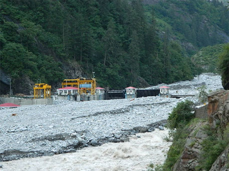
Was this really an emergency, or was this purely opportunistic on the part of NHPC to take this opportunity early in the season to flush their reservoir that had been filled almost to half with bed-load and silt? We went looking for clues and information. I went to the NHPC office complex at Dobat, and met Bhuvan Chand Joshi, their Public Relations Officer. After giving me the spiel on how safe, and how green this so called run-of-the-river (ROR) project was, constructed by no less than the Japanese, the Germans and the Koreans put together[2], he admitted that their underground power-station was entirely flooded. Housed in a gigantic underground cavern about 100 meters long, four-storeys high at 40 meters and about 16 meters wide, river water had filled it right upto the control-room on the fourth floor. I had already been told by Kesar Singh Dhami, taxi owner of Dharchula, that on the 16th June itself, when he was ferrying the first batch of Kailash yatris to the road-head on their way up to Tibet, he had noticed the reservoir was filled high already with flood-waters, with large uprooted trees and other woody debris floating at the damsite. He confirms that water was being released, but only a small release, despite the dam being fuller than he had ever seen it.

I was also told by another employee of NHPC (who did not wish to be named) that what had gone wrong was that despite the high flows on the 15th and 16th June, the power-station continued with production of electricity as usual. In what seems to be an unbelievably short-sighted and poor design, the Tail-race Tunnel, from where water is released back into the river after having turned the turbines, is flushed into a tributary stream, the Ellagad. It was when Ellagad also pulsed, that it sent a train of bed-load debris down its lower reaches, effectively blocking the exit of the Tail-race Tunnel coming out of the powerhouse. The power house continued to take in water from the Head-race Tunnel intake to work their turbines, unaware that the exit for water had been blocked. It is only when the water blocked in the Tail-race Tunnel surged back up, burst through the turbine units and began flooding the powerhouse, that NHPC even know that something was wrong. It was then that the massive curved steel gates of the intake were slid shut, and the powerhouse evacuated. This was further confirmed by Joshi, PRO, who also said that the ‘matter was under investigation’ by their own team for organizational detail. The General Manager and the Chief Engineer of the Dhauliganga HEP had meanwhile been transferred out. It is not clear yet how soon after the powerhouse was flooded, that they opened the sluice gates at the bottom of the reservoir. Draining it was clearly beneficial for NHPC, but catastrophic for roads, bridges and habitations downstream, both in India and Nepal.

Dhauliganga before the disaster, with zero water flow downstream from the dam, killing a perennial river. Source: Author

If you look closely enough, there are two separate events here. The flooding of the powerhouse, and the ’emergency’ release of reservoir water. The powerhouse was not flooded because of too much water in the reservoir, but because it was in operation when its tail-race exit seven km downstream, is blocked-off because of poor short-sighted design[3]. They are then forced to close the gates of the intake, and abandon the powerhouse where water has reached the control-room on the fourth floor. The intake gates are now shut, but the flood waters continue to fill the reservoir further. They have already allowed the dam fill to a very high level, and here is the other curious factor.

The design of the Dhauliganga dam, is such that the dam has no provision for water to ‘overflow’ the dam safely, should undesired (even if foreseeable) levels be reached as they did this year. Or say if giant boulders block the narrow sluice gates at the bottom of the reservoir. Or in the real-time situation of what actually happened this year, the blocking of the tail-race tunnel leading to flooding of the powerhouse, hence requiring the shutting off of the intake, and losing the option of reducing reservoir levels more gradually and safely through two simultaneous releases. They then open the flood-gates. Clearly, one of two things have led to this decision:

One, letting the reservoir fill to a very high level is not out of the ordinary for NHPC; they do it every monsoon, as they had done on 16th June as well. It is not for many months in the year that they have enough water to run all four turbines. Despite the run-of-the-river label, Joshi confirmed that they were unable to let any water to continue to flow un-diverted in the river-channel during the winter-spring months (we have photographic evidence of this as well), or they would not have water to turn even one turbine! The mandatory requirement that every hydro-power dam in Uttarakhand be required to release at least 10% of the river’s minimum flows at all times (as greatly insufficient as such a small flow is for downstream life), it seems neither a consideration while justifying the economics of such projects, and neither is it complied to here. The use of the term run-of-the-river here, is plain deception.

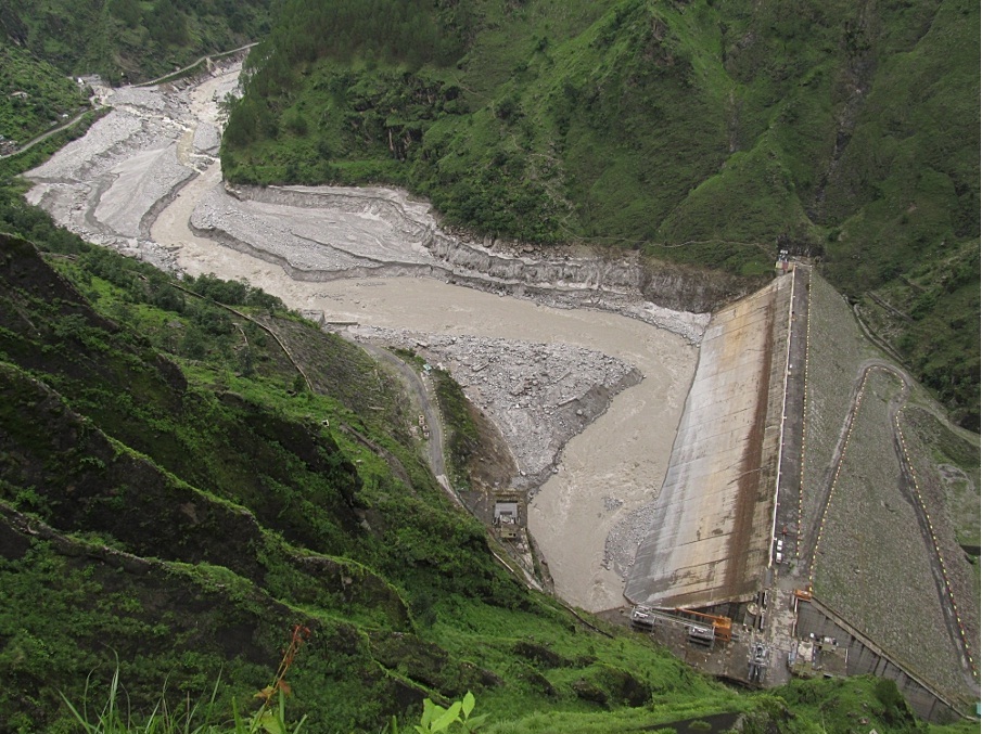
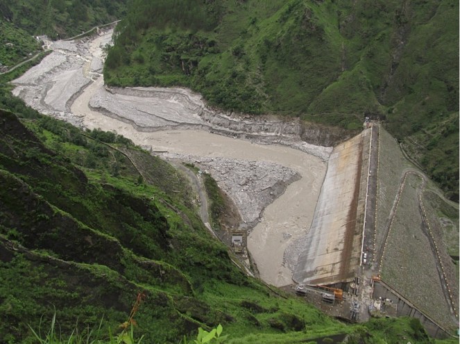
The Dhauliganga Hydro-power dam, after being flushed of bed-load sediment Source: Author
The Dhauliganga Hydro-power dam, after being flushed of bed-load sediment
Source: Author

Their regular annual schedule for flushing the reservoir of bed-load and sediment is normally the 15th of July and the 31st of July every year. Here again, when the reservoir is full, and there is enough water to provide the pressure for increased and accelerated flow to flush the reservoir on a twice-annual basis. Both flushing schedules follow each other closely at peak-flow season, so that the flushing is as complete as possible, and there is enough of a monsoon season ahead to fill the reservoir up again before the winter-lean. The probable reason for preponing the flushing could be the chance of flushing some of the unusually high accumulation of bed-load debris that had come down in this years flood. What this meant to the efficiency of the power-station is one thing, but what it means to all life in and along the river, is quite another.

Two, that the faulty design of the dam, both in location of its tail-race exit as well as no provision for over-topping, in combination with the carelessness of allowing the reservoir to fill to such levels at the start of the monsoon, was responsible for the ’emergency’ catastrophic release.

Stitched photo of the bed of the drained Dhauliganga reservoir  Source: Author
Stitched photo of the bed of the drained Dhauliganga reservoir
Source: Author

The Dhauliganga HEP is located on the Darma–yangti river, re-christened the Dhauliganga  river, just a couple of kilometers upstream of the confluence with the Mahakali at Tawaghat. In these two kilometers, the rivers flows (twice a year when it is allowed to, for a few hours) down steeply to the confluence which it meets at right-angles. With the Mahakali already in spate, coupled with the sudden release of more than 6 million cubic meters of stored water (Gross Storage Capacity), plus the flow of the river in flood (steadily increasing from 398 cubic meters a second on 15th June), as well as millions of tonnes of bed-load boulders and sediment, the damage downstream is clear to see. If you look at the fresh scour-level on the banks downstream of the dam, it is in places more than 15 meters higher than the flood-level flow of the DhauliRiver. The river added thousands of tonnes of even more debris when, because of the flood level it reached, it tore through, plucking high at the talus-cones on either bank, and at every turn. At the confluence at Tawaghat, there must have been something of a back-flood for some time (a common flood phenomenon where the high-flowing main-stem creates a temporary water-dam), because the water-level seems to have risen very high, taking away the bridge that connects the entire Kuti valley and the trade route to Tibet,   tearing away almost the entire village-market complex at Tawaghat, and destroying the road as well. The flood waters had clearly reached the top of the road because of the deposition of river-sand on it. When I walked this section days later, the river was only less than a meter below danger mark. Even so, it was flowing about 12 meters below the road! Further downstream, the destruction was more serious.

In order to understand the magnitude of this flood event, I ask Joshi of NHPC for flow-data of the Dhauli river between the 12th and the 18th of June. He goes off for some time and returns with a sheet of paper that has hand-scrawled 6 hourly flow volumes from 12th June, but stops short at 15th June. All the flow volumes between the 12th and the 15th were below 150 cubic meters a box 1second (cumecs), and at 12 am, on the night of the 15th June it jumps up to 389.92 cumecs. This is just the start of the flood. Joshi seems to balk right here, and says that they have not received data for the 16th June yet (the day I speak to him was the 8th of July), and that he may get it after a week or so. And anyway, he says, the powerhouse was abandoned from the night of the 16thJune, so getting data beyond that would be out of question. It is clear that Joshi was unwilling to give me flow-data for the duration of the flood-pulse. He had only minutes before informed me of how automated the whole operation was, and that it was possible for them to even operate the power-house sitting in their Dobat office-complex itself. The real scenario will be clear when we get flow data for the 16th and 17th of June.
According to NHPC, the Peak Flood Design for the Dhauliganga HEP is 3,210 cumecs, at a return interval of 100 years. That is the flow volumes that the dam is designed to be able to take without damage, at flood levels expected at least every hundred years. It is unlikely that flow volumes had reached almost 10 times the flow volumes of the flood on the 15th June at the damsite (389.92 cumecs). NHPC gets its flow data from an automated level-gauge at the reservoir, so it did not require anyone to take readings manually, even prior to abandoning the station. If unprecedented levels had indeed been reached, then why had they held on to water in the reservoir right till the night of the 16th June?  Please see the accompanying photographs, of the dam reservoir, empty of water. You can see at least two levels of cut-away terraces. The lower ones are alluvial terraces, consisting clearly of coarser gravels and cobbles deposited by the flowing river. The higher terraces, more visible high on the upper true-left bank in the photo, are remnant lacustrine (lake-bed) terraces, consisting of finer silts and sand, deposited by the stilled waters in the reservoir when it was full. This was the highest point of sediment accumulation in the reservoir prior to being flushed out. Clearly, at least 45% the reservoir was full of debris and sediment before NHPC flushed it. And if you look at the brown line on the concrete face of the dam, you see the level that the reservoir was allowed to fill upto, marked by the ‘bath-tub ring’ of floating bark and woody debris stuck there after draining.

Joshi tells me that when a delegation of people from Nepal came to NHPC to talk about the possible role that NHPC’s sudden release of water might have had on the flood that devastated Khalanga bazar at Darchula, he had told them that to the contrary, the dam had saved Nepal from great damage. “See how much debris is still behind our reservoir!” This was bare-faced misinformation. There are two aspects being denied here. One, that great masses of debris were actually flushed out from the lower-end of the reservoir on the night of 16th June, leading to greatly increased flood levels as well as erosive potential downstream, especially on the Nepal bank at Darchula, which bore the brunt of flushed debris centrifuged on the curve. As is evident from the photo of the dam-site above, most of the debris that has been flushed, is from the front-end of the reservoir only. And two, that all dams and reservoirs, despite some being able to flush out debris from a section of the reservoir, do actually hold back a great deal of bed-load as well as suspended sediment in the upper end of the reservoir. They impede the very essential flow of sediment down to the oceans. Look now at the geometry of bed-load debris in the stitched photo. Distortions from the wide-angle lens apart, it clearly shows a gradual slope, and a filling up of the bed-rock channel to form a wide, sloping flood-plain. Had it not been for the dam, the bed-load would have continued to fill up the bed-rock channel downstream at about the same angle, slowing the entire flow of water and entrained debris. It would not have been washed down catastrophically all the way down to Darchula, without the force of an additional 6 million m³ of stored water released suddenly.

Emmanuel Theophilus (etheophilus@gmail.com)


[1]    NHPC never gives warning of sudden releases. There is a notice painted on a board at Tawaghat, the first river-side habitation downstream, that warns people not to go anywhere near the river, because water may be released anytime.

[2]    Kajima Construction Corporation Ltd of Japan, Daewoo Engineering and Construction Company of Korea, and Bauer Maschinen of Germany.

[3]    How a tail-race exit could be planned on the Ellagad stream which is very steep and unstable, full of debris from a service tunnel, and highly ‘flashy’, is indicative of poor design and of lax design approval mechanisms.

Climate Change · Uttarakhand

Uttarakhand Rainfall: Since 1901 and in light of the 2013 disaster

During the tragic Uttarakhand disaster, one of the most discussed but the most elusive topics has been rainfall. Uttarakhand, though having experienced frequent extreme weather events, has a poor distribution of rain gauge stations and weather monitoring. The worst hit districts like Rudraprayag, Chamoli and Pithoragarh have especially dismal distribution of monitoring stations, making it impossible for us to understand the intensity of rainfall in places like Kedarnath when the disaster struck. (https://sandrp.wordpress.com/2013/06/21/uttarakhand-deluge-how-human-actions-and-neglect-converted-a-natural-phenomenon-into-a-massive-disaster/)

According to the Indian Meteorological Department (IMD) June 2013 rainfall was over thrice the normal amount between June 1 and 21. The highest figure quoted by IMD was 370 mm a day at Dehradun, which was said to be ‘a record not seen for five decades’. IMD has also said that in the week of 13th to 19th June, the entire state of Uttarakhand received 847% excess rainfall, and that this has no precedent.[1] However, according to experts, this generalisation of a very diverse state does not depict the true picture.

Nonetheless, it is worthwhile to string together whatever data we have on Uttarakhand’s rainfall in order to get a clearer picture of rainfall trends, and also underline the fact that Uttarakhand and all the other Himalayan States need a much denser network on weather monitoring stations, representation all altitudes, river basins & sub-basins and climatic zones. Only then will the data be a useful tool in planning and forecasting.

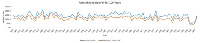
In this piece, we have tried to analyse rainfall datasets of the hundred years (1901-2000) for some of the worst affected and vulnerable districts of Uttarakhand. This data has been obtained from Indian Meteorological Department. Districts analysed include Uttarkashi, Rudraprayag, Haridwar, Chamoli, Tehri Garhwal, and Pithoragarh.

While we have rainfall data from 1901-2000 (with some gaps), there is a gap in the data during 2000-2008. Then again we have data from 2008-2012 and 2013 till 25th September 2013. (All figures from IMD – India Meteorological Department – http://imd.gov.in/).

What we have attempted here is:

1.     Identification of Top 5 Maximum and Minimum rainfall events in the selected 7 districts in the past 100 years. Comparison of these values with 2013 Maximum monthly rainfall

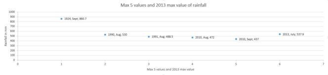
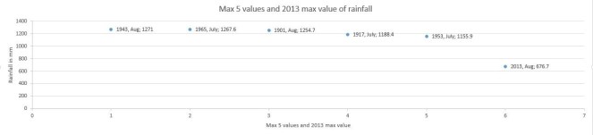
Interesting to note that the only time when 2013 monthly (approximate, as we have weekly figures from IMD, not monthly ones) features in top 5 monthly rainfall is for Chamoli, in July 2013! 537.9 mm rainfall it received in July 2013 was the second highest recorded rainfall in the district since 1901-2000 and 2008-2013.

2.   100 year monthly monsoonal and annual rainfall for selected 7 districts, 2008-2012 monsoonal and annual rainfall for selected 7 districts.

3. 2013 weekly rainfall collated in respective months for June, July and August for the seven districts.

Results:

1.             Dehradun: 

  • Maximum monthly rainfall in last 100 years during monsoon months (Same for all districts below): 1271 mm in August 1943
  • Minimum rainfall in last 100 years during monsoon months: 20.4 mm in June 1965
  • Maximum rainfall of 2013 compared with the 5 previous maximums: In August 2013 it received 676.7 mm rainfall which was maximum for the district in 2013 monsoon.

However, this did not figure amongst the top 5 values for monsoon rainfall in the period considered.

  • Rainfall during the week 13-06-13 to 19-06-13: 565.4 mm
  • Departure from normal for the same week – 1436%

Dehradun_Reshaped

Deharadun_100_Years

2. Uttarkashi:

  • Maximum rainfall in last 100 years: 800.8 mm in August 1963
  • Minimum rainfall in last 100 years: 36.8 mm in June 1987 
  • Maximum rainfall of 2013 compared with the 5 previous maximums: In 2013, 529.9 mm received in June was the highest for the 2013 monsoon season.

However, this does not feature among the top 5 values for monsoon rainfall in the period considered.

  • Rainfall during the week 13-06-13 to 19-06-13: 375.6 mm
  • Departure from normal for the same week: 1356%

Uttarkashi_ReshapedUttarkashi_100_Years

3. Tehri Garhwal-

  • Maximum rainfall in last 100 years– 1097 mm in September 1995
  • Minimum rainfall in last 100 years- 0 mm in September 1997
  • Comparison of 2013 max rainfall with the previous 5 maximum: In 2013, 453.4 mm rainfall received in June was the highest for the 2013 monsoon season.

However, this does not feature among the top 5 values for monsoon rainfall in the period considered.

  • Rainfall during the week 13-06-13 to 19-06-13: 327.7 mm
  • Departure from normal for the same week – 390%Tehri Garhwal_ReshapedTehri Garhwal_100_Years

4. Haridwar-

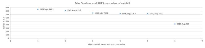
  • Maximum rainfall in last 100 years: 848.2 mm in September 1924
  • Minimum rainfall in last 100 years: 0 mm in September 1971
  • Maximum rainfall of 2013 compared with the 5 previous maximums: In 2013, 426 mm rainfall received in August was the highest for the 2013 monsoon season.

However, this does not feature among the top 5 values for monsoon rainfall in the period considered.

  • Rainfall during the week 13-06-13 to 19-06-13: 298.8 mm
  • Departure from normal for the same week – 1283%

Hardwar_Reshaped

Hardwar_100_Years

5. Rudraprayag

  • Maximum rainfall in last 100 years – 914.6 mm in August 1925
  • Minimum rainfall in last 100 years – 0 mm, in September 1971
  • Maximum rainfall of 2013 compared with the 5 previous maximums: In 2013, 664 mm rainfall received in June was the highest for the 2013 monsoon season.

However, this does not feature among the top 5 values for monsoon rainfall in the period considered.

  • Rainfall during the week 13-06-13 to 19-06-13:366.3 mm
  • Departure from normal for the same week – 580%

Rudraprayag_ReshapedRudraprayag_100_Years

6. Pithoragarh-

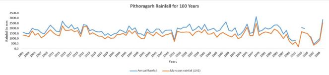
  • Maximum rainfall in last 100 years 1057 mm in August 2000
  • Minimum rainfall in last 100 years 22 mm in June 1901
  • Maximum rainfall of 2013 compared with the 5 previous maximums: In 2013, 471.9 mm rainfall received in July was the highest for the 2013 monsoon season.

However, this does not feature among the top 5 values for monsoon rainfall in the period considered.

  • Rainfall during the week 13-06-13 to 19-06-13: 246.9 mm
  • Departure from normal for the same week – 238%

 Pithoragarh_ReshapedPithoragarh_100_Years

7. Chamoli

  • Maximum rainfall in last 100 years–860.7 mm in September 1924
  • Minimum rainfall in last 100 years– 0 mm in 1998
  • Maximum rainfall of 2013 compared with the 5 previous maximums: In 2013, 537.9 mm rainfall received in July was the highest for the 2013 monsoon season.

It was a second maximum recorded rainfall since 1901-2000 and 2008-2013.

  • Rainfall during the week 13-06-13 to 19-06-13: 316.9 mm
  • Departure from normal for the same week – 1302%

Chamoli_Reshaped

Chamoli_100_Years

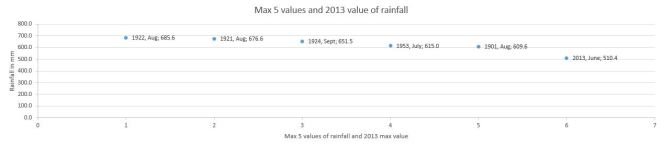
8. For Uttarakhand state-

  • Maximum rainfall in last 100 years – 685.6 mm in August 1922
  • Minimum rainfall in last 100 years – 28.1 mm in September 1907
  • Maximum rainfall of 2013 compared with the 5 previous maximums: In 2013, 510.4 mm rainfall received in June (June 1 to July 3) was the highest for the 2013 monsoon season.

However, this does not feature among the top 5 values for monsoon rainfall in the period considered.


Uttarakhand_ReshapedUttarakhand_100_years

In conclusion While presenting data for entire districts, we realise that there have been major variations in rainfall experienced within a district, for example, parts of Pithoragarh received extremely high rainfall during 15th-19th June, but the average rainfall for Pithoragarh District in June 2013 (Period between 06.06.13-03.07.13) is only 418.4 mm. The week between 13 June 2013-19th June 2013 shows only 238% departure from normal rainfall, when the higher reaches of Pithoragarh received some of the heaviest rainfall in Uttarakhand in June 2013.

As per researcher Emmanuel Theophilus, from Himal Prakriti at Munsiyari, Pithoragarh, the rainfall data with IMD for the entire Pithoragarh Districts  is  only from 2 stations in  the mid altitude areas, where it hardly rained much. Hence, the discrepancy, of Pithoragarh having only a 238% departure from normal, whereas the NASA maps show one of the darkest blue spots in Pithoragarh as well. In addition, he says: “IMD has only a very few stations scattered sparsely over the state, and what they have, are located in central district and sub-division office locations. Sure this makes for easy gathering of data, but is of little use for understanding any particularities, even at the sub-basin scale. In just the Gori sub-basin (Pithoragarh) for example, rainfall can vary from 15 cm annually, (spread over ~28 rainy days a year, and not counting snow) in the higher alpine Trans-Himalaya reaches, to as much as 4 meters, yes meters, of rain annually (spread over ~152 rainy days a year, and again not counting snow) just 50 km downstream, in the Greater Himalaya. Therefore, statements such as ‘the entire state of Uttarakhand received 847% excess rainfall’, can be misleading.”

After the Uttarakhand Disaster of unprecedented proportions, let us hope that now IMD, Uttarakhand Government, heavily funded programs like National Climate Mission, Universities, research institutes[2], etc can come together to create reliable and representative weather monitoring stations in the vulnerable state. Only through such data will a robust forecasting system be supported.

Damodar Pujari and Parineeta Dandekar

END NOTES:


[1] From Emmanuel Theophilus: A River Pulse. A discussion paper on the flood-events in June 2013, Mahakali basin, Uttrakahand. Himal Prakriti, Sept 2013

[2] Here it may be noted that some institutes have their own automatic and other rain-gauge stations, but data from such stations is not in public domain. For example, Wadia Institute of Himalayan Geology (http://www.wihg.res.in/) is supposed to have at least two automatic weather stations at Chorabari lake upstream of the worst impacted Kedarnath, but the data from these stations was not put up in public domain promptly or even now. Such data can be of great use for disaster forecasting, management and other purposes, but cannot be put to use without the data being in public domain.

Uttarakhand

Uttarakhand Flood disaster: Supreme Court’s directions on Uttarakhand Hydropower Projects

On August 13, 2013, while disposing off a bunch of petitions[i] regarding the controversial 330 MW Srinagar Hydropower Project on AlaknandaRiver in Uttarakhand, the Supreme Court bench of Justice K S Radhakrishnan and Dipak Misra have given some welcome directions on the Uttarakhand hydropower projects.

Perusal of the full judgment[ii] shows that the decision is disappointing on the Srinagar project issue, since the court has directed that the project be completed and disposed off all objections to that, while asking for implementation of the Environment Managemnet Plan and conditions etc. However, there are several contradictions in this regard that seems to have escaped the attention of the court, and a review petition on that part could be field by the petitioners. Importantly, Prof Bharat Jhunjhunwala, who argued the case in person, should be thanked for the role he played in this case.

Courts’s concerns on Uttarakhand Hydro Projects However, the most pertinent and interesting part of the order starts at the bottom on p 62 with the title “Court’s concerns” and goes on till the end of the order on p 72.

In these pages, the order notes that AHEC (Alernate Hydro Energy Centre at IIT Rurkee) has not done the cumulative impact assessment it was asked to do. This is very important to note. The order says, (para 46), “We have gone through the Reports and, prima facie, we are of the view that the AHEC Report has not made any in-depth study on the cumulative impact of all project components like construction of dam, tunnels, blasting, power-house, Muck disposal, mining, deforestation etc. by the various projects in question and its consequences on Alaknanda as well as Bhagirathi river basins so also on Ganga which is a pristine river.” After this clear statement from the Highest Court, no one should rely on this report now on.

We are glad that this statement of Supreme Court supports what SANDRP has been saying for years[iii].

This part the order also refers to the BK Chaturvedi Committee (appointed by the National Ganga River Basin Authority in June 2012) report submitted in April 2013 to emphasise that, “The River Ganga has over a period of years suffered environmental degradation due to various factors.” The court should have directed that the MoEF should make the report of the BK Chaturvedi committee report public since the MoEF has not yet done that. The committee itself stands discredited[iv] since none of the independent members of the committee accepted the report.

The operative part of the order says:

“(1) We direct the MoEF as well as State of Uttarakhand not to grant any further environmental clearance or forest clearance for any hydroelectric power project in the State of Uttarakhand, until further orders.”

This means that environment or forest clearance to any hydropower projects of any size in Uttarakhand cannot be given either by MoEF or by the Government of Uttarakhand till further orders.

“(2) MoEF is directed to constitute an Expert Body consisting of representatives of the State Government, WII, Central Electricity Authority, Central Water Commission and other expert bodies to make a detailed study as to whether Hydroelectric Power Projects existing and under construction have contributed to the environmental degradation, if so, to what extent and also whether it has contributed to the present tragedy occurred at Uttarakhand in the month of June 2013.”

This direction has two parts: A. assessment of cumulative impacts of existing and under construction hydropower projects[v] to the environment degradation in Uttarakhand and B. Whether the projects have contributed to the Uttarakhand flood disaster, if so to what extent.

Only a credible independent panel with sufficient number of independent members can provide a credible report in this regard, the committee should be chaired by a non government person of the stature of Prof Madhav Gadgil. We hope the MoEF will soon constitute such an expert body and also ask the expert body to hold public hearings at various relevant places and seek wider public consultation. The mandate of the committee should be for the entire Uttarakhand and not just Bhagirathi and Alaknanda sub basins. The committee should have credible and independent geologist, sociologist, environmentalist, river expert and disaster management expert.

“(3) MoEF is directed to examine, as noticed by WII in its report, as to whether the proposed 24 projects are causing significant impact on the biodiversity of Alaknanda and BhagirathRiver basins.”

Here it may be remembered that it was MoEF that had asked Wildlife Institute of India to submit a report on the cumulative impact of the hydropower projects in Uttarakhand on aquatic and terrestrial biodiversity. It should also be remembered that WII is one of the credible institutes and is also a centre of excellence of the MoEF. There is no reason for MoEF to reject the clear recommendation of the WII report that the 24 projects listed by it should be dropped. The clearances given to the projects like the 300 MW Alaknanda Badrinath HEP of GMR should be suspended immediately keeping this direction in mind.

“(4) The Disaster Management Authority, Uttarakhand would submit a Report to this Court as to whether they had any Disaster Management Plan is in place in the State of Uttarakhand and how effective that plan was for combating the present unprecedented tragedy at Uttarakhand.”

This direction should have also been for the National Disaster Management Authority since preparation of proper State Disaster Management Plan and ensuring setting up of required machinery for its implementation is also a mandate of the NDMA. This is particularly important in view of the failure also of NDMA as reported by the Comptroller and Auditor General of India report of March 2013. Since the court has asked in para 52 that, “Reports would be submitted within a period of three months. Communicate the order to the Central and State Disaster Management Authority, Uttarakhand.”, it is implied that NDMA is also to submit a report.

Since the original petitions and applications are disposed off, it is not clear if the original petition survives or a new case will be registered. It is also not clear if the original petitioners survive. In such cases it is the normal practice of the court to appoint and Amicus Curie and it would be interesting to see whom the court appoints for such a purpose.

These orders are indeed welcome in view of the fact that hydropower projects in Uttarakhand have certainly played big role in increasing the disaster potential and disaster proportions in Uttarakhand floods in June 2013. More than twenty groups and individuals of Uttarakhand, Himachal Pradesh and other states have already written to the MoEF in July 2013[vi], asking for suspension of such hydropower projects that have prime facie played such a role and set up an independent enquiry. The MoEF has not yet responded to this letter. We are glad now SC has asked for such an inquiry.

South Asia Network on Dams, Rivers and People (https://sandrp.in/)

August 14, 2013


[i] These includes Civil Appeal No 6736 of 2013, Special Leave Petition no 362 of 2012, Civil Appeal nos 6746-47 of 2013 (arising out of SLP (Civil) nos 5849-50 of 2012 and Transfer cases (C) (National Green Tribunal) numbers 55 to 57 of 2013.

[v] For basin wise and size wise details of existing, under construction and planned Hydropower projects in Uttarakhand see: https://sandrp.wordpress.com/2013/07/10/uttarakhand-existing-under-construction-and-proposed-hydropower-projects-how-do-they-add-to-the-disaster-potential-in-uttarakhand/

Floods · Hydropower · Uttarakhand

Gangani Hydroproject on Yamuna in Uttarakhand: Small Project, Huge Flood Damages

IMPACT OF UTTARKHAND FLASH FLOODS IN MID JUNE 2013 ON LOCAL PEOPLE AT KHARADI VILLAGE (BARKOT BLOCK) IN UTTARKASHI DISTRICT RESULTING FROM A DIVERSION/ REDIRECTION OF THE YAMUNA RIVER TOWARDS POPULATED BANK OF THE RIVER DUE TO THE 8 MW GANGANI HEP. IMPACT IS ALSO THERE ON THE HEP INFRASTRUCTURE ITSELF PUTTING A QUESTION MARK ON ITS QUALITY OF CONSTRUCTION AS ON ITS SUSTAINABILITY.

YAMUNA JIYE ABHIYAAN, JULY 2013
Text by Manoj Mishra

Kharadi is a small road side market place on river Yamuna, some 40 km short of the holy shrine of Yamunotri. It is also a popular night halt site on the Char Dham Yatra route. Resultantly over the period of time a number of hotels and residential properties have come up along the road and the river side.

Gangani1
Redirection of the river to the left due to the project head. All Photos taken on 20 July 2013, by Bhim Rawat, Yamuna Jiye Abhiyaan

Some time in 2008-09 works, started by a pvt firm called Regency Gangani Energy Private Limited, immediately upstream of the Kharadi village for the construction of a 8 MW run of the river HEP. The works involved a diversion head, laying of pipes to convey the diverted river water and a power house around 5 km down stream of Kharadi at a place called Gangani. It is notable that the planned HEP is on the proper river Yamuna

By the year 2012, construction works had progressed to a considerable extent, when on the night of 3 August 2012 a cloud burst at Hanuman Chatti area resulted in a flash flood in the river Yamuna. Flow of Yamuna was obstructed by the diversion head of the HEP and was diverted towards its more populated left bank. This diversion swept away of around 9 hotels and residential properties of the local people at Kharadi. It also resulted in damages to the pipes laid in and near the river bed by the HEP.

If the above was not enough then on 17 June 2013, another cloud burst and heavy rains over most of higher reaches of Uttarakhand led to yet another diversion of the river and sweeping away of around 28 properties (see list at the end of this report) in the market village of Kharadi.

Washing away of structures in Kharadi some 500 m downstream from the river diversion head of the Gangani HEP by the flash flood in the river Yamuna on 17 June 2013

The Project also applied for Clean Development Mechanism (CDM) status under United Nations Framework Convention on Climate Change to get Carbon Emission Reduction Credits. Yamuna Jiye Abhiyaan and others have objected to this application at the Validation stage earlier and at registration stage now in August 2013 as the project is not only unsustainable, but its application was full of contradictions and misleading claims. The project is in any case not a sustainable Development Project, is business as usual project and hence non additional as per UNFCCC criteria. The project is also not sustainable development project, but India’s National CDM Authority, namely the Union Ministry of Environment and Forests, has never done credible assessment of this, and never rejected any application of CDM hydro projects!

Road and structures washed away by the flash flood in the Yamuna river downstream from diversion head of the Gangani HEP.
Damaged pipes (meant to carry the river water to the Gangani HEP power plant some 3 km d/s from the diversion head) and the damaged approach bridge on the river

List of Hotels and residential properties destroyed in Kharadi village by the flash floods in river Yamuna made worse due to the diversion head of the HEP upstream of the Kharadi village on the night of 16 and morning of 17 June 2013 and on the night of 3 August 2012 around 11 PM made worse (as per local people) due to the Gangnani HEP structure (head) in the river upstream of the village

Property/Hotel Owner Name Father’s Name Village Name No. of Rooms
1 Neel Kanth Hukum Singh Rawat, Sri Lal Singh Khanera Three Storey, 20 rooms
2 Unnamed Jagdish, Chandar Mohan, Ajay Sri Attar Singh Khanera 2 rooms + Provision Shop
3 Yamuna Darshan Jaidev Singh Rana Sri Jandar Singh Khanera 25 rooms
4 Bhupendar Place Rajendar Singh Chouhan, Sri Narendar Singh Syalna 12 Rooms
5 Bhupendar Palace (Joint) Gajendar Singh , Sri Narendar Singh Syalna 04 Rooms
6 Bhupendar Palace (Joint) Arjun Singh, Kesar Singh Syalna 04 Rooms
7 Amit Restaurant Jogindar singh, Sri Chandan Singh Bhansadi 05 Rooms
8 Govind Palace Janak Singh Sri Ranjor Singh Khanera 12 rooms
9 Him Darshan (August 12) Atol Singh, Sri Jai Singh Chouhan Nagon Gaon 22 Rooms
10 Naveen Palace Jag Mohan Chouhan, Sri Jhoon Singh Khanera 06 Rooms
11 Naveen Palace Man Mohan Singh, Sri Jhoon Singh Khanera 04
12 Naveen Palace Dharmendar , Sri Jhoon Singh Khanera 04
13 Vijay Restaurant Vijay Chouhan, Sri Jhoon Singh Khanera 1 Hall, 1 Cottage
14 Naveen Palace Darmyan Singh, Sri Kamal Singh Syalna 07
15 Provision Singh Jagveer Singh chouhan Sri Surveer Chouhan Khanera Provision Shop
16 Ravindar Palace Ravindar Singh Sri Budhi Singh Khanera 04 Rooms
17 Kahniya Palace Shailendar Singh Sri Shiv Singh Khanera 04 Rooms + Restaurant
18 Rana Place Kitab Singh Rana Sri Surb Singh Rana Khanera 04 Rooms
19 Residence Gabar Singh Sri Sultan Singh Khanera 04 Rooms
20 Residence Bijendar Singh Sri Sabal Singh Khanera 07 Rooms
21 Residence Brij Mohan Sri Jogolia Khanera 06 Cottages
23 Residence Chojen Lal Sri Kuta Singh Syalna 04 Rooms
24 Residence Basant Lal Sri Khelan Singh Khanera 03 Rooms
25 Residence Trepan Lal Sri Sadhu Lal Syalna 02 Rooms
26 Residence Jogi Lal Sri Jhapuliyan Khanera 02 Rooms
27 Aneesh Place Aneesh Sri Janbeer Khanera 06 Rooms
28 Residence Jendar Singh Sri Keval Singh Khanera 02 Rooms
29 Residence Praveen Singh Sri Jandar Singh Khanera 02 Rooms
30 Residence Jagendar Singh Sri Keval Singh Khanera 02 Rooms
31 Narayan Place Kendar Singh Payal Sri Ram Singh Syalna 05 Rooms
32 Residence Chain Singh Sri Rompal Singh Syalna 04 Rooms
33 Residence Ispal Singh Sri Khajan Singh Syalna 04 Rooms
34 Narayan Palace (Joint) Ranbeer Singh Sri Ghayan Chand Syalna 04 Cottage
35 Narayan Palace (Joint) Chain Singh Sri Daya Ram Singh Khanera 02 Rooms + Canteen= 02 cottage (About to fall)
36 Giri Ashram Saint Giri Kharadi
37 Trishul Hotel Kandra Singh Payal Sri Ram Singh Syalna Verandah Damaged
Bold entry relates to properties washed away in Aug 2012.

NOTE:
About 25 additional Households have now (after June 2013 floods) come with in the slip zone, which can now slip or get washed away any time in the event of high rainfall or another flood.
Entire Kharadi village has now been declared as disaster affected by the District Administration.

YAMUNA JIYE ABHIYAAN, JULY 2013
(Text by Manoj Mishra)

Floods · Hydropower · Uttarakhand

Uttarakhand Floods: Truth about THDC and Central Water Commission’s Claims about Tehri

June 28, 2013

The claim of THDC, CWC and Uttarakhand Chief Minister that in absence of Tehri dam, Rishikesh and Haridwar would have been washed away is completely baseless and unfounded, nothing but a hype. Facts show that if Tehri Dam id not exist, the water level in downstream towns may have risen on June 16-17, before the levels actually rose on June 18 (as per CWC, peak level in Rishikesh was 340.8 m and in Haridwar at 295.1 m, both on June 18), but are likely to be lower than the levels of June 18 since peak flow in Alaknanda (around 11000 cumecs) was lower than that in Bhagirathi (6900 cumecs). THDC and CWC should refrain from making such claims as they are more like adding salt to the wounds that the people of the state are now experiencing and where dams and hydro projects have played a big role.

From all accounts, it is clear that peak flood in Bhagirathi River on which Tehri dam is situated, occurred on June 16 and the peak flood in Alaknanda occurred on June 17 and not at the same time. So it is not rational to add the two peaks happening at different points of time to claim that Tehri saved downstream areas. If Tehri was not there, there could have been floods in downstream a day earlier, but that does not mean peak level would have been much higher than what was the case with Tehri Dam.

From the records available on the websites of Central Water Commission (http://cwc.gov.in/Reservoir_level.htm) and Central Electricity Authority (http://cea.nic.in/daily_hydro.html), it is clear that water level in Tehri reservoir rose from 749 m on June 15 to 776.8 m on June 18 (water levels for June 16 and 17 are not available for some strange reason), this translated to increase in water storage by 652 Million Cubic meters (MCM). THDC claims that they experienced peak inflow of 244 000 cusecs and moderated that to an outflow of 14000 cusecs. To achieve this moderation for a day would take storage capacity of around 563 MCM, so it is plausible that they achieved this moderation on June 16, when Bhagirathi was experiencing peak flow.

However, as we noted earlier, the peak flow in Alaknanda happened on June 17. THDC should make public hourly figures of flow in Bhagirathi and Alaknanda on June 15-19, outflow from Tehri on each of those hours, level of Ganga at Devprayag, Haridwar and Rishikesh, so that everyone can assess the reality of their claim. Such information should in fact be in public domain in routine way.

It cannot be forgotten that:

  • Areas downstream of Tehri dam faced avoidable and unprecedented flood disaster in September 2010 (for details see page 20 of Aug Sept 2010 issue of Dams, Rivers & People: https://sandrp.in/drp/DRP_Aug_Sept_2010.pdf). If the dam operation is not done properly, we may be in for a repeat later this season.
  • It should also be recalled that Tehri is a ticking time bomb in the context of large earthquake that is imminent in the state as seismologists are telling us.( including eminent seismologists like Dr. Vinod Gaur. For more details: Earthquakes and Large Dams in Himalayas)
  • In fact, Tehri Dam sits on an active fault and seismincity near Tehri area is also related to loading and unloading ot the resrvoir (http://www.currentscience.ac.in/Volumes/103/11/1343.pdf)
  • Tehri dam has also been cause of large number of landslides along periphery of the reservoir. In fact, when Tehri dam was about to be complete, 28 workers had died when working in the water diversion tunnel. (http://www.infochangeindia.org/disasters/news-scan/29-killed-in-tehri-canal-collapse-early-warnings.html)
Landslides and debris flowing into Tehri Reservoir. 2012. Matu Jan Sangathan
  • People affected by the Tehri dam have still not been rehabilitated, the dam has also not been delivering the peaking power it could, as noted by Central Electricity Regulatory Authority. The dam is also silting up much faster than envisaged, reducing its water holding and power generation capacity.

In fact, CWC has failed in its flood forecasting as we made it clear earlier. Both CWC and THDC need to put their house in order rather making unfounded claims.

Himanshu Thakkar (ht.sandrp@gmail.com, 09968242798)

South Asia Network on Dams, Rivers & People  (https://sandrp.in/)

For SANDRP blogs on Uttarakhand flood disaster, see:

1. https://sandrp.wordpress.com/2013/06/21/uttarakhand-deluge-how-human-actions-and-neglect-converted-a-natural-phenomenon-into-a-massive-disaster/

2. https://sandrp.wordpress.com/2013/06/23/uttarakhand-floods-disaster-lessons-for-himalayan-states/

3. https://sandrp.wordpress.com/2013/06/25/uttarakhand-and-climate-change-how-long-can-we-ignore-this-in-himalayas/

4. https://sandrp.wordpress.com/2013/06/25/central-water-commissions-flood-forecasting-pathetic-performance-in-uttarkhand-disaster/