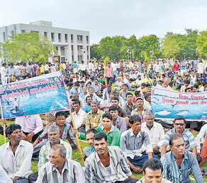
Since May 2017, several flood related incidents have taken place in the North East showing how our shortsightedness in understanding the rivers, how our thoughtless construction along the rivers in the name of flood control and how our careless operation of dams have converted floods into a disaster.
At the same time, there have been incidents raising suspicion over quality of construction of built and ongoing dams. Then the news of NHPC being accused of forging Gram Panchayats signs to build 520 MW Teesta IV dam is shocking revelation in itself. Contribution of such factors in worsening the floods is always underplayed.
The countless landslides and Cyclone Mora (http://www.hindustantimes.com/india-news/cyclone-mora-reaches-northeast-many-houses-damaged-in-mizoram/story-UzcDuPOge0drAklftXW38L.html) have already left the region crippling, despite this there is no regular monitoring of flood situation and no timely warning being issued by States or Central Agencies about the rainfall and floods. All this is enough to prove that the ongoing flood devastation in North East has very much to do with the way we are destroying rivers with hydro projects, dams and embankments and disturbing the fragile environment of North East. These incidents also put question mark before govt agencies which are first pushing the destruction in the sensitive region and then lagging way behind in monitoring and issuing timely precautionary warnings.
Today is 13th day of the Swami Shivanand fast unto death to protect Ganga River from illegal mining. The health of 70 years old Marti Sadan head is turning critical with each passing hour. If no intervention is done immediately, the Saint’s life will be in danger.
Matri Sadan resumed its fight against rampant mining in Ganga on May 13th, 2017 after State Government opened Ganga riverbed mining which the Ashram is strongly opposing for last many years.
For first eleven days two disciples of the Ashram observed hunger strike. But seeing no response from Govt, Swami Shivanand himself sat on fast unto death on May 24, 2017 against indiscriminate mining of national river. Still the Govt went ahead with Ganga mining activities stating that it was necessary to protect the city from flood.
In response the Saint shunned even taking water. But instead of communication with the protesters, the State Govt reportedly on May 28, 2017 triedto force feed the saint to fail the agitation for which the Govt was criticized greatly.
After mounting pressure the CM of Uttarakhand is learnt requesting to stop hunger strike. Following this mining was stopped in Ganga and the saint started taking water after six days but decided to continue fast as long as Government imposes complete ban on mining in writing.
On June 02, 2017, accusing the State Govt of blatant apathy towards Swami Shivanand’s hunger strike against illegal mining on the Ganga riverbed in the Kumbh Mela area, a group of scientists, activists and followers have written to the PM Modirequesting the PM to intervene without delay to stop unscientific mining of the Ganga.
Bihar Chief Minister Nitish Kumar again has urged the central govt to remove the Farakka barrage in West Bengal and make a countrywide policy on silt management for letting river Ganga to flow freely.
Speaking on the occasion, Swami Avimukteshwara Anand criticised Union Water Resources Minister Uma Bharati for doing absolutely nothing for the cause of the river Ganga and said she seems more interested in her chair rather than the river. He also criticised Prime Minister Modi for claiming that he is son of Ganga, but doing nothing positive for the river. Swami ji said Nitin Gadkari seems bent on further destroying the river in the name of National Waterway.
Addressingthe seminar Nitish Kukar said that Bihar’s demand for the framing of national policy on desiltation of the Ganga and clearance of silt in the state is not a political issue, as the matter is related to larger environmental and biodiversity issues facing the people.
He added, “Concrete steps have to be taken to ensure incessant flow of the Ganga. Otherwise, cleanliness of the river is not possible.” Referring to the need to protect biodiversity, he said conservation of the Ganga dolphins is dependent on the cleanliness of its water. He added the Farakka barrage constructed across the river in West Bengal has led to slow flow of water between Buxar to Bhagalpur, and consequent annual flood and waterlogging during the monsoon.
Nitish recalled the devastating flood that the state had witnessed in the Ganga basin last year and said Bihar had spent Rs 1,058 crore over the last five years to prevent soil erosion. He appealed to the Centre to frame a sound policy on silt management, stressing that it should be prepared by making on the spot survey and assessment of the prevailing situation. Nitish said even the report of the committee headed by Madhav Chitale had accepted the problem of siltation facing the Ganga.
We have noticed during just concluded South West monsoon season that IMD (India Meteorological Department) has started a new and welcome feature in rainfall data reporting[i]. The Data is available in maps, on daily, weekly and seasonal basis. We are not sure when this practice started, we noticed it only during 2016 monsoon season.
This is most welcome development, since getting rainfall data at basin level is most appropriate and useful, since basin is the hydrological unit that will experience the impact of rainfall or lack of rainfall in the basin, in form of floods or droughts. It can also be very useful for flood forecasting and preparedness, among many other uses. We hope IMD will develop and refine this further.
In each map, the actual rainfall for the given period is given for each basin, as also the normal rainfall & % departure from normal. Usual colour code is used to show the basin as blue if rainfall is more than 120% of normal rainfall, green if rainfall is 81-119 %, brown if rainfall is 60-80% of normal and yellow if rainfall is below 60% of normal rainfall.
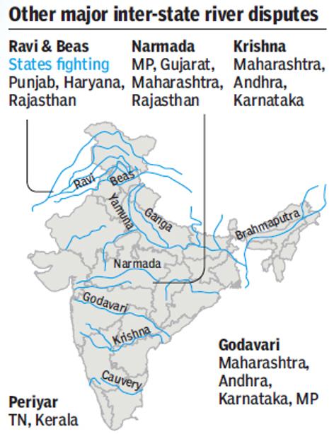
Water sharing disputes across the country (and even beyond) are only going to escalate with increasing demands, and also with increasing pollution & losses reducing the available water. Climate change is likely to worsen the situation as monsoon patterns change, water demands going up with increasing temperatures, glaciers melt and sea levels rise. The government’s agenda of interlinking of rivers would further complicate the matters.
The ongoing Cauvery Water Dispute [iv] has once again brought the focus on interstate river water sharing disputes in India and what has been our experience so far. There is no solution of Cauvery water dispute in sight and the engineer-dominated Cauvery Management Board that the Cauvery Water Dispute Tribunal Award has recommended is unlikely to help matters. Continue reading “Inter state River Water Disputes in India: History and status”→
Above: Parshuram Kund on River Lohit, Arunachal Pradesh
Since 2005, last Sunday of every September is celebrated as the World Rivers Day. The tradition started in 1980s in British Columbia when some river activists came together for their rivers. Its only grown since then.
All through the year we hear about water conflicts, river pollution, degrading freshwater biodiversity, damming of living rivers, mismanagment, concretisation and encroachment on Indian Rivers. As I write this, Cauvery Water Conflict and simmering, serious discontent over the Indus Water Treaty governing 6 rivers between India and Pakistan is mounting. A simple google search on Indian Rivers throws up images of filth, pollution, droughts and floods. Lest we forget, thats not the whole picture. We are still the custodians of an amazing legacy. India still holds some of the most beautiful, healthy and life giving rivers in the world. There are people and communities nurturing their rivers and protecting them. All is not lost and this is a battle worth fighting, full of positive energy.Continue reading “Celebrating our Rivers on the World Rivers Day, 2016!”→
Above Map of Cauvery basin from Indian Express, Sept 22, 2016
Higher demands than availability is the key problem in Cauvery basin. transparent, participatory, democratic, rule based management of demands over supply is the key need. Unfortunately, we do not have that. Greater misfortune is that the Cauvery Water Disputes Tribunal Award of Feb 2007, even as it is significantly flawed, is yet to be implemented since the Special Leave Petitions of Karnataka and Tamil Nadu, admitted in the Supreme Court, remain pending for over nine years now. The Supreme Court, in the meantime, (through its orders of Sept 5, 12 and 20) deals with the issue in a manner, that seems ad hoc in absence of clarity as to how all the relevant factors have been taken into account. Continue reading “Cauvery: Is there will for way forward? Will constitution of CMB help?”→
Is there hope for India’s Environment from Mr Anil Dave? Most shocking statements from India’s environment Minister. He says let us do Ken Betwa link when the project has NONE of the statutory clearances from his own ministries. The independent committees are yet to appraise the project and yet he is saying: “This Ken-Betwa river link we should do it and have an impact assessment after five years. If it is good, then great, if not they don’t go for other linkages.” Is there any hope for India’s environment? As he says, YE SAB CHALTA HAI!!
Reliable data and information that is both correct and validated on ground, is a pre requisite to understand any feature or activity. And for a river, a constantly evolving and truly complex entity, it becomes even more crucial. The wellness quotient of rivers, their present health status, all these and more can only be understood, once we have the rudimentary knowledge of the river and the basins that they form.
A step in this direction has been taken up by the India WRIS (Water Resources Information System) project (A joint venture between Central Water Commission and Indian Space Research Organisation), that aims “to provide a ‘Single Window Solution’ for water resources data & information in a standardized national GIS framework”[i]. This project has generated 20 basin level reports that share important information on the salient features of the basin, their division into sub basins, the river systems that flow through it and the water resource structures, such as irrigation & hydro electric projects in the basin. Another crucial inclusion is the length of major rivers in each basin, which have been GIS calculated (Geographic information system)[ii] and in a few reports the place of origin of the rivers too is mentioned. (Ganga Basin Report). This is an improvement over the earlier documented river lengths that included the canal length along with the river lengths, in earlier CWC documents (e.g. water and related statistics)!
The Basin reports include basin level maps which also show the proposed inter basin transfer links and the major water resource structures & projects. Individual maps at the sub basin level mark the rivers & their watersheds. The report gives details on the topography, climate, the land use / land cover area , and also the information on hydro meteorological stations like groundwater observation cells, flood forecasting sites and even water tourism sites.
These reports can be downloaded from the WRIS site.[iii]
The reports are an attempt to document the water resources data & information for a better and more integrated planning, at the basin level. A table below tabulates some important parameters from the 20 basin reports.
Missing Dams! It can be seen from table on next page that total number of dams in all the 20 basins come to 4572. Assuming that this includes all the completed large dams in India by Dec 2013 (WRIS report is dated March 2014), if we look at the number of large dams in India as in Dec 2013 in the National Register of Large Dams (NRLD), the figure is 4845. This leaves a difference of 273 large dams, which are missing from the WRIS list! This seems like a big descripancy. Unfortunately, since NRLD gives only statewise list and does not provide river basin wise list and since WRIS list provides only river basin wise list and does not provide the names of districts and states, it is not possible to check which are the missing dams, but WRIS need to answer that.
Sub Basins These 20 basins have been further delineated into a number of sub basins. The sub basins details include the geographical extent of the sub basin, the rivers flowing in it, the states that they travel through, number and size range of watersheds and also the details of dams, weirs, barrages, anicuts, lifts & power houses, accompanied by maps at this level. The irrigation and hydro electric projects in the area are detailed and mapped for greater convenience. The sub basin list is given here to get a detailed picure.
Indus Basin Sub-basins:
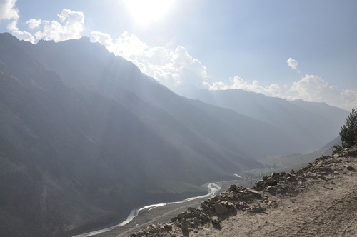
River Dras in Indus Basin in Jammu and Kashmir (Photo by Sabita Kaushal)
Beas Sub Basin
Chenab Sub Basin
Ghaghar and others Sub Basin
Gilgit Sub Basin
Jhelum Sub Basin
Lower Indus Sub Basin
Ravi Sub Basin
Shyok Sub Basin
Satluj Lower Sub Basin
Satluj Upper Sub Basin
Upper Indus Sub Basin
S. No
River Basin
Major river
No. of sub basins
No. of watersheds
No. of water resource structures
No. of water resource projects
Irrigation
Hydro Electric
Dams
Barrages
Weirs
Anicuts
Lifts
Power Houses
Major
Medium
ERM*
1
Indus (Upto border)
Indus (India)
11
497
39
13
18
0
45
59
30
40
21
55
2a
Ganga
Ganga
19
980
784
66
92
1
45
56
144
334
63
39
b
Brahmaputra
Brahmaputra (India)
2
180
16
17
5
0
4
21
9
13
3
17
c
Barak & others basin
Barak
3
77
4
3
0
0
0
3
0
6
3
3
3
Godavari
Godavari
8
466
921
28
18
1
62
16
70
216
6
14
4
Krishna
Krishna
7
391
660
12
58
6
119
35
76
135
10
30
5
Cauvery
Cauvery
3
132
96
10
16
9
24
16
42
3
15
6
Subernarekha
Subernarekha & Burhabalang
1
45
38
4
12
0
0
3
5
34
0
1
7
Brahmani & Baitarni
Brahmani & Baitarni
2
79
61
5
4
1
0
1
8
35
4
1
8
Mahanadi
Mahanadi
3
227
253
14
13
0
1
6
24
50
16
5
9
Pennar
Pennar
2
90
58
0
1
2
0
1
7
14
0
1
10
Mahi
Mahi
2
63
134
0
4
0
0
3
10
29
3
2
11
Sabarmati
Sabarmati
2
51
50
2
10
0
0
0
9
11
4
–
12
Narmada
Narmada
3
150
277
2
2
0
4
9
21
23
1
6
13
Tapi
Tapi
3
100
356
8
11
0
13
2
13
68
2
1
14
WFR Tapi to Tadri
Many independent rivers flowing
2
96
219
0
3
0
1
18
13
15
1
12
15
WFR Tadri to Kanyakumari
3
92
69
6
6
4
0
29
19
12
7
21
16
EFR Mahanadi_ Pennar
4
132
64
5
12
12
0
0
12
46
10
0
17
EFR Pennar _ Kanyakumari
4
165
61
2
2
11
0
6
13
33
4
5
18
WFR Kutch _ Saurashtra
Luni
6
268
408
1
10
0
0
0
8
100
4
15
19
Area of inland drainage in Rajasthan
Many independent rivers flowing
–
–
1
0
0
0
48
0
11
1
1
0
20
Minor rivers draining into Myanmar(Burma) & Bangladesh
Many independent rivers flowing
4
54
3
5
0
0
3
–
3
4
1
–
Total
94
4335
4572
203
335
* Extension, Renovation and Modernization ** Data has been accumulated from the individual Basin Reports from India WRIS[iv]
Ganga Basin
Yamuna Lower
Yamuna Middle
Yamuna Upper
Chambal Upper
Chambal Lower
Tons
Kosi
Sone
Ramganga
Gomti
Ghaghara
Ghaghara confluence to Gomti confluence
Gandak & others
Damodar
Above Ramganaga Confluence
Banas
Bhagirathi & others ( Ganga Lower)
Upstream of Gomti confluence to Muzaffarnagar
Kali Sindh and others up to Confluence with Parbati
Brahmaputra Basin It is strange to see that the profile divides this huge basin into just two sub basins, when it could have easily divided into many others like: Lohit, Kameng, Siang, Subansiri, Tawang, Pare, Teesta, Manas, Sankosh, among others.
Brahmaputra Lower
Brahmaputra Upper
Barak & Others Basin
Barak and Others
Kynchiang & Other south flowing rivers
Naochchara & Others
Godavri Basin
Wardha
Weinganga
Godavari Lower
Godavari Middle
Godavari Upper
Indravati
Manjra
Pranhita and others
Krishna Basin
Bhima Lower Sub-basin
Bhima Upper Sub-basin
Krishna Lower Sub-basin
Krishna Middle Sub-basin
Krishna Upper Sub-basin
Tungabhadra Lower Sub-basin
Tungabhadra upper Sub-basin
Srisailam Dam on Krishna River (Source: Wikipedia)
Cauvery Basin
Cauvery upper
Cauvery middle
Cauvery lower
Subernarekha Basin No sub-basins.
Brahmani & Baitarani Basin
Brahmani
Baitarani
Mahanadi Basin
Mahanadi Upper Sub- basin
Mahanadi Middle Sub- basin
Mahanadi Lower Sub- basin
Pennar Basin
Pennar Upper Sub-basin
Pennar Lower Sub-basin
Mahi Basin
Mahi Upper Sub-basin
Mahi Lower Sub-basin
Sabarmati Basin
Sabarmati Upper Sub- basin
Sabarmati Lower Sub-basin
Narmada Basin
Narmada Upper Sub-basin
Narmada Middle Sub-basin
Narmada Lower Sub-basin
Tapi Basin
Upper Tapi Sub- Basin
Middle Tapi Sub- Basin
Lower Tapi Sub- Basin
West flowing rivers from Tapi to Tadri Basin
Bhastol & other Sub- basin
Vasisthi & other Sub- basin
West flowing rivers from Tadri to Kanyakumari Basin
Netravati and others Sub- basin
Varrar and others Sub- basin
Periyar and others Sub- basin
East flowing rivers between Mahanadi & Pennar Basin
Vamsadhara & other Sub- basin
Nagvati & other Sub- basin
East Flowing River between Godavari and Krishna Sub- basin
East flowing River between Krishna and Pennar Sub- basin
East flowing rivers between Pennar and Kanyakumari Basin
Palar and other Sub-basin
Ponnaiyar and other Sub-basin
Vaippar and other Sub-basin
Pamba and other Sub-basin
West Flowing Rivers of Kutch and Saurashtra including Luni Basin
Luni Upper Sub-basin
Luni Lower Sub-basin
Saraswati Sub-basin
Drainage of Rann Sub-basin
Bhadar and other West Flowing Rivers
Shetrunji and other East Flowing Rivers Sub-basin
Area of inland drainage in Rajasthan Due to very flat terrain and non-existence of permanent drainage network, this basin has not been further sub divided.
Minor rivers draining into Myanmar and Bangladesh
Imphal and Others sub basin
Karnaphuli and Others sub basin
Mangpui Lui and Others sub basin
Muhury and Others sub basin
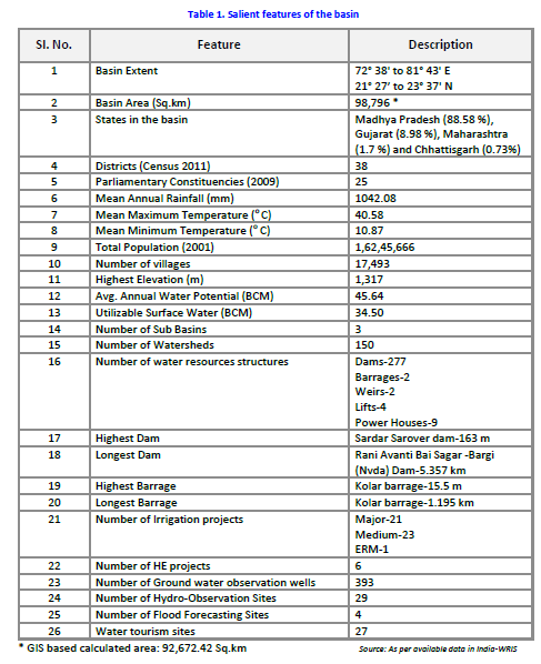
Narmada Basin: Some details To understand the compiled information at the basin level, we take a look at the one of the basin level reports, the Narmada Basin Report[v] (dated March 2014) as an illustrative example. An overview of the basin area right at the beginning, gives its geographical location, shape, size, topography, climate & population. This basic relevant information is tabulated in a concise table for easy access, as given below:
Salient Features of Narmada Basin from WRIS Basin Report
River information The major river flowing in the basin, the Narmada River (also called Rewa) that flows through the 3 states of Madhya Pradesh, Maharashtra & Gujarat, its length (1333 km) and the length of its 19 major tributaries out of a total of 41 is given, based on GIS calculations. There is also a clear river network map of the Narmada basin that demarcates the 3 sub basins along with the watersheds, and shows the dams / weirs /barrages and the rivers in the basin.
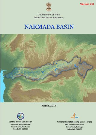
Narmada Basin Report Cover Page (Source: WRIS)
Narmada Upper Sub-Basin, with 16 watersheds
Narmada Middle Sub-Basin, having 63 watersheds
Narmada Lower Sub-Basin, with 71 watersheds
The surface water bodies details include the size (less than 25 ha to more than 2500 ha) and type (Tanks, lakes, reservoirs, abandoned quarries or ponds) of existing bodies. Nearly 91.8% of these are tanks.
Irrigation Projects The water resource projects in the basin are as follows:
21 Major Irrigation Projects
23 Medium Irrigation Projects
1 ERM Project
6 Hydro-Electric Projects
Interestingly description is only of the major and medium irrigation projects, information on minor projects is completely absent. An attempt to include the details of minor irrigation projects would have made the report more useful. The reports seem to not understand the significance of the smaller projects and their importance for the people and in the conext of the River Basin too.
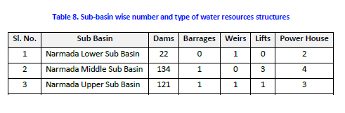
Water resource structures The number and type of big manmade structures in the basin is given. These are a total of 277 dams, 2 barrages, 2 weirs and 4 lifts, of which again the major structures are marked on a map, and details given as in table below. Dams are classified on the basis of storage and purpose they are used for, and the dam numbers are available at sub basin level.
Narmada Sub Basin details from WRIS Basin Report
The report gives tabulated data for each of the dams, which is supposed to have name of the river, height, length, purpose, year of commissioning, etc. Since GIS is the strength of ISRO, they could have easily given latitude and longitudes of each dam, but they have not. Shockingly, in case of 186 of the dams, name of the river on which it is built is given as ‘Local Nallah’, and in case of 10 they have left the column blank. This means for nearly 71% (196 out of 277) of the dams they do not even know the name of the river they are build on. This is actually an improvement over the performance of CWC. The CWC’s National Register of Large Dams[vi], we just checked, mentions Narmada only 13 times (for 12 dams of Gujarat and 1 dam of Madhya Pradesh).[vii]
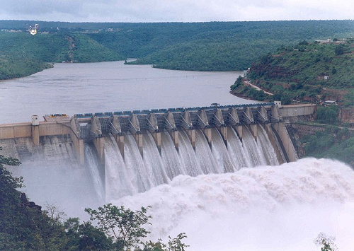
It is well known that Narmada Basin is the theatre of India’s longest and most famous anti dam movement, Narmada Bachao Andolan. The movement involves opposition to Sardar Sarovar, Indira Sagar, Omkareshwar, Maheshwar, Jobat dams, among others. Such social aspects should also form part of any river basin report.
Surface water quality There are 19 surface water quality observation sites in the basin, that collect water data and the report spells out , “As compared to the other rivers, the quality of Narmada water is quite good. Even near the point of origin, the quality of river water was in class ‘C’ in the year 2001 while it was in class ‘B’ in earlier years. As was observed for most other rivers, in case of Narmada also, BOD and Total Coliform are critical parameters.” This shows that even in Narmada Basin, water quality is deteriorating. The statement also remains vague in absence of specifics.
Inter basin transfer links Details of the Par-Tapi-Narmada Link, which is a 401 km long gravity canal and its proposal to transfer 1,350 MCM (Million Cubic metre) of water from ‘surplus rivers’ to ‘water deficit’ areas is given, along with a map. How has the conclusion of surplus or deficit been reached? Does the assessment exhaust all the options including rainwater harvesting, watershed development, groundwater recharge, better cropping patterns and methods, demand side management, optimising use of existing infrastructure, etc? Is this is the least cost option? Does the water balance include groundwater? Who all will be affected by this or even how much land area will be affected by this proposal, there is absolutely no talk of this? No answers in the report.
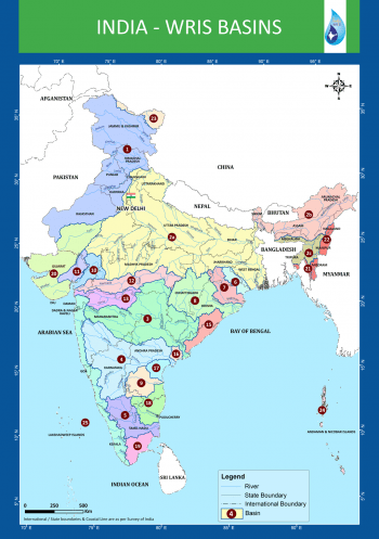
India River Basins Map (Source – WRIS)
There’s more to a river There is no information in basin reports on the regulating or statutory bodies that have a say in the basin in the report. However, some information on the existing organisations and inter-state agreements at the various basin level is given at another WRIS location.[viii]
The Basin reports for 20 basins are clearly an asset for understanding and analysing water resource situation. However, there is no mention of the numerous ecological, social and environmental services these rivers provide us with. The demographic details of the basin are available, but there is no information on the flora and fauna, who also need and thrive on the river waters. A good navigation tool for water resource information and river management projects at basin level, nevertheless, for a broader and more comprehensive outlook these reports should have included the following essential aspects too:
River status: The present water quality & pollution level of the major rivers as well as their tributaries
River governance: The local committees, civil bodies and institutions that play a role in river basin development
River safety measures: Effect of the existing and planned river management projects on the state of the river, people and society.
River ecology: Status of biodiversity, and other ecological aspects of the rivers
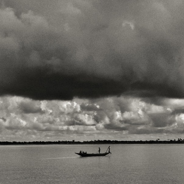
Above: Hilsa fishers in Bangladesh setting out for their journey Photo: with thanks from Arati Kumar-Rao
In addition to the Gangetic Fisheries Primer, SANDRP will shortly publish a Primer documenting the Impacts of dams on Riverine Fish and Fisher Communities. One of the most profound impacts of dams on fish is blocking migration routes and perhaps no other fish symbolizes this impact as dramatically as the Hilsa: the Silver Queen of the River.
Glimpses of the impacts of dams on Hilsa in South Asia.
Arguably, Hilsa is not just a tasty and healthy fish species that migrates from the sea up the river to spawn. It is a cultural icon that binds Bengalis, whether from West Bengal or Bangladesh, together in their shared love for Ilish Machch. Pohela Baishakh or the new year day’s meal is not complete without Ilish. Though Hilsa is celebrated fervently by the Bengalis, it is prized in all estuaries of South Asia, from Narmada, Mahanadi, Godavari, Cauvery to Indus and Irrawaddy and takes the name of Chaski, Palva, Ilishii, Palla, Pulasa, etc. It is also found at confluence of Tigris and Euprates in Iran, where it is as prized and known as Sbour. The fish flavours several poems, folklore, songs and phraseologies of the entire South Asia. In cultural terms, the significance of Hilsa is comparable only to Salmon and Mahseer.
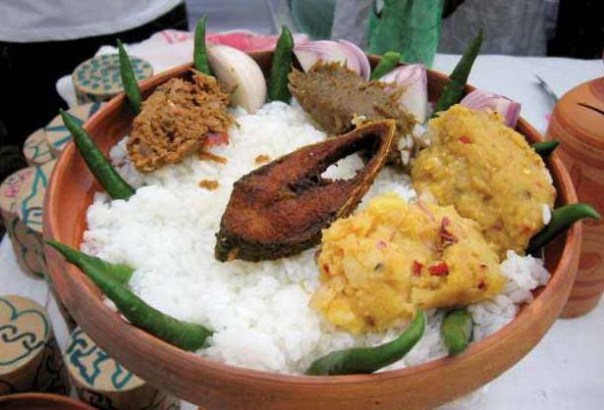
Ilish fish and rice, a religious offering and cultural fare on Pohela Baishakh Photo: Flickr
Tenualosa ilisha, Hilsa or Indian Shad belongs to the sub family Alosinae of Family Clupeidae. Commercially, it is the most important fisheries in the estuaries, especially in the Ganga-Hooghly region.It occurs in marine, estuarine and riverine environments and is found in Indus of Pakistan, Irrawaddy of Myanmar and Indian rivers like Ganga, Bhagirathi, Hooghly, Rupanarayan, Brahmaputra, Godavari, Narmada, Cauvery, Tapti, coastal rivers like Padma, Jamuna, Meghana, Karnafuly and others in Bangladesh. It is seen to migrate up smaller estuaries like Pennar too.
Hilsa, by habitat, is a marine fish but migrates in estuaries and rivers for spawning, normally inhabiting the lower region of the estuaries and the foreshore areas of the sea. Hilsa ascends the rivers for spawning and the spent fish and their progeny migrate down the river towards lower estuaries and coastal areas, moving in shoals. The peak upstream migration of Hilsa in most of the rivers of the country is generally in the monsoons months of July and August and continues upto October or November. The spring spawners that enter the river for spawning in January-March return to the sea during July-August when these are caught in good numbers. The monsoon spawners that enter the river during September- October return to the sea after spawning and these spent fishes are caught in good numbers during January- March. Similarly, the off springs of spring-spawners make journey for the sea from the river during November- January, whereas the off springs of monsoon spawners return to the sea from the river during July- September. (Bhaumik et al, CIFRI, 2012)
Obstruction to undertaking this spawning migration by dams and barrages has been singled out as the primary reasons for the fall of Hilsa fisheries in India as well as Bangladesh. The trade of this commercially important fish species constitutes upto 1.5% of Bangaldesh’s National Gross Domestic Product and about 2 million fishers are estimated to depend on Hilsa fisheries in Gangetic estuaries. Till August 2014, Bangladesh has stopped Hilsa exports to India to contain astronomic price rises in Bangladesh as the costs of the fish are becoming uncontainable due to its cultural importance on one hand and dwindling supply on the other. India has requested Bangladesh to lift the ban of Hilsa export, but it is yet to relent, due to a number of socio-political reasons. [2]
Fishers setting off for Hilsa from the Bangladesh Sunderbans Photo: With thanks from Arati Kumar-Rao
One of the main reasons for the phenomenal fall of Hilsa in Gangetic delta has been the Farakka Barrage built by India in the 1970’s, just a few kilometers upstream the India –Bangladesh border, to divert water from Ganga into the Hooghly river, to keep the Kolkata Port at the mouth of Hooghly, free of sediments.
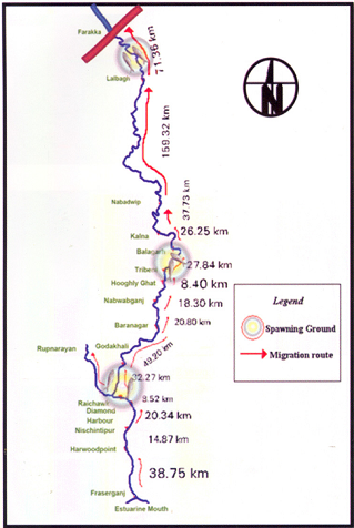
Prior to commissioning Farakka Barrage in 1975, there are records of the Hilsa migrating from Bay of Bengal right upto Agra, Kanpur and Delhi covering a distance of about 1400 kms. Maximum abundance was observed at Buxar, near Allahabad, at a distance of about 650 kms from river mouth. Post Farraka, Hilsa is unheard of in Yamuna in Delhi and its yield has dropped to zero in Allahabad, from 91 kg/km in 1960s. Studies as old as those conducted in mid-seventies[3] single out Farakka’s disastrous impacts on Hilsa, illustrating a near 100% decline of Hilsa above the barrage post construction.
Migration route of Hilsa, Pre Farakka Barrage spanning about 1400 kms Source: CIFRI 2012
Highly restricted range of Hilsa post Farakka Source: CIFRI
An obligatory Fish lock provided in Farakka Barrage is non-functional and tagging experiments reveal that Hilsa cannot move across the barrage due to obstruction of three-tire sluice gates.[4] For more on how Farakka has failed its objective and continues to impact livelihoods: https://sandrp.wordpress.com/2014/11/25/lessons-from-farakka-as-we-plan-more-barrages-on-ganga/
Fishers who live off the Ganges strongly feel the pressure of dams, personified by Farakka. In north India, ‘Farakka’ –the word doesn’t mean a village on the Bangladesh border anymore, but means destruction by dams. The local Hindi dialects have borrowed new phraseology: “Farakka hua, tabse hilsa toh bas bhabis” (Farakka happened, and then Hilsa exist only in imagined future)”. The same phrase repeats up to the Yamuna River! In a recent status survey of Gangetic fisheries almost 75-80% of fishers singled out ‘Farakka’ as the root cause of all their miseries. They actually referred to multiple barrages built on the respective rivers. But destruction had a common name: Farakka.[5]
Bangladesh has been making several serious attempts to revive Hilsa fisheries and implements a strict fishing ban in certain months to avoid fishing “jatkas” or small Hilsa. It has also declared several Hilsa Sanctuaries to protect the fish and is witnessing small and steady improvements in the population. India has hardly taken any steps to protect this specie. IUCN has led a program called Ecosystems for Life: A Bangladesh-India Initiative and Hilsa fisheries is a part of this project. There is also a Norwegian project on Hilsa Aquaculture [7] ( All prior efforts of Hilsa Aquaculture have failed). However, the primary need to address the giant problem of the Farakka Barrage is being unaddressed. The barrage and reduced freshwater in the downstream is also exacerbating other stressors like sedimentation of the river mouth, high fishing pressure on limited stocks, concentrated pollution, etc.
Hilsa in other Rivers (would taste as sweet!) Hilsa is found not only in Ganges delta but most of the estuaries in India. In all of these places, Hilsa fishery is primarily affected by dams and barrages near the estuaries, blocking spawning migration and reducing freshwater from upstream.
Hilsa in Cauvery: A century of impacts In Tamizh, Hilsa caught at Sea is Kadal Ullam and the one in the River is the Aattu Ullam. Here, the impact of Mettur dam on valuable Hilsa fisheries in the Cauvery has been recorded as early as 1939 in an issue of Current Science, where it is stated: “Unfortunately the effect of the dam (Mettur on Cauvery) on the fisheries below was disastrous. The number of valuable Indian Shad or Hilsa, the most important sea fish ascending the Cauvery for breeding purposes, declined as the high floods which enabled them to ascend the rive no longer occur. The serious decline of fisheries in Cauvery would be evident from the fact that the fishery rental of the river below the dam which used to amount to 80000 Rs. annually has steadily declined since the formation of the dam to about 42,900 rupees.”[8]Puntius species also disappeared in Cauvery post dam, which formed 28% of the landings prior to dam construction.[9]
As per the Report “Fishing the Cauvery: How Mettur Changed it all,” by Ramya Swayamprakash published by SANDRP[10], It was Sir Aruthur Cotton himself, way back in 1867 who alerted the erstwhile government about the damages wrought by weirs on river fisheries. Immediately, Dr. Francis Day was commissioned to investigate the impact on fisheries and subsequently appointed Inspector-General of Fisheries in India. In his report on the fisheries of India and Burma, Day condemned dams as insurmountable barriers to fish passage; he designed a fish passage which was on the Lower Anicut on the Kollidam. The pass was primarily designed for the Hilsa who could not ascend it, as it was too wide. According to the Madras Fisheries department in 1909, the fish pass did not ensure Hilsa migration because of various practical and technical difficulties; in the first place, the expenses for the construction of a fish pass were not commensurate with the expected results and secondly, sufficient water could not be provided for the efficient working of the pass. Interestingly, Hilsa was sought to be cultivated and exported along the lines of the Salmon in north-western United States. So important was the Hilsa that a stuffed specimen made its way into the exhibits sent to the Great Exhibition from the Bombay Presidency, in 1851!
Fishing at the Lower Anicut on Cauvery Photo: Wikimedia Commons
Today, the Hilsa is unknown on the Cauvery. According to fish biologists, the Hilsa ascended the anicuts on the Cauvery up to Mettur to spawn overcoming the low anicuts. But the coming of the Mettur Dam formed an impassable barrier.
Hilsa in Godavari is known as Pulasa when caught i the river and Vilasa when caught n the sea! Here too, the fish is declining and main reasons are said to be declining water levels and the Dowleswaram Barrage [11] (Arthur Cotton Barrage). In Andhra villages too Pulasa has a huge cultural significance.
This author made a presentation to the Standing Committee of the Lok Sabha, the lower house of Indian Parliament in June 2012 about the impacts of dam on riverine fish and discussed Hilsa, when an MP from Coastal Godavari district in Andhra Pradesh said, “I know Pulasa! My constituency depends on riverine fisheries like Pulasa, and not marine fisheries, but we end up talking only about marine fish and not river fish and Pulasa and the impacts of upstream projects on livelihoods of river fishers”
Pulasa/ Hilsa of the Godavari Photo: The Hindu
In Mahanadi, Orissa, Hilsa has been hit by dams and is recording a declining trend[12]. Paradip recorded about 500 tonnes Hilsa, but prices have increased astronomically.[13]
Hilsa in Narmada, Sardar Sarovar and the proposed Bhadbhut Barrage The narrative of damming the Narmada by the Narmada Valley Projects is one of the most significant stories of an on-going struggle against modifying a river and way of life of her people. Although there are many facets to the story ranging from displacement, false benefits and true costs, forest loss, non-existent rehabilitation and an all-pervasive insensitivity of the government towards weaker communities, the impacts of this project on riverine fisheries have been equally profound. Narmada River system experienced a nearly 70% decline in Hilsa catches in just a decade between 1993 to 2004 ( From 15319 t to 4866 t ) and this decline was prominently recorded from 1998-99 onwards.[14] As per CIFRI, the most stressed species after Sardar Sarovar Project (SSP) construction is the Hilsa and Macrobrachium prawn (Jumbo River Prawn). CIFRI made some prediction about impacts of the dam after 35 years, calling it a ‘critical period’ when fisheries will be nearly lost. Shockingly, these conditions are already being witnessed in Narmada Estuary in Bharuch which records nearly 30% Inland Fish production. More than 12,000 people from 21 villages in Bharuch alone depend on Narmada Estuary for fisheries.
Assessment of impact of commissioning of Sardar Sarovar dam and other projects in 2009 by CIFRI revealed that SSP will retain 96% of the sediment, adversely affecting biological productivity of the downstream including Narmada estuary.[17] However, already the Sardar Sarovar and upstream dams in Narmada Basin have already resulted in retention of about 95% sediment, cutting off the delta from nutrient rich silt. Historical sediment discharge of Narmada was 61 million tonnes and the current sediment discharge (average of last ten years of the study) was found to be 3.23 million tonnes.[18]
According to CIFRI, “While the annual inflow is 23.68 MAF (1981-1990), it will be reduced to 15.9 MAF after 10th year of SSP, to 4.34 MAF at the 30th year and will cease at the 45th year. This freshwater decline will severely affect Hilsa fishery and prestigious fishery contributed by M rosenbergii (Jumbo River Prawn)”. As freshwater declines, there will be “Steep hike in salinity regime with tidal ingress. Fishery not tuned to such enhanced salinity will succumb to such pressure. Mangroves will also be affected and this will impact marine fish production as Mangroves are nurseries of many marine fish.”
Gujarat Government has agreed to release 600 cusecs water from Sardar Sarovar and Bhadbhut Barrage as environmental flows. There is no study as to whether this amount is sufficient for estuarine balance, for ecological needs of Hilsa or other species, for spawning migration, etc. Also, there is no guarantee that Gujarat will release this meagre quantity. Ironically, the minimum flows of 600 cusecs agreed to be released by Gujarat through SSP come to 532. 9 Million Cubic Metre (MCM) water annually and CIFRI’s warning of a sharp fisheries decline at 30th year was for 4.34 MAF or 5353.4 MCM! So, 532.9 MCM released now as minimum flows is barely 10% of a dire scenario predicted at 30th year of commissioning SSP[i]!
It is hardly a wonder that Hilsa is falling sharply in Narmada Estuary and fishers are directly blaming the Sardar Sarovar for this decline.[19]
Last Straw for Narmada Hilsa: Bhadbhut Barrage: Gujarat Government is planning to build Bhadbhut Barrage about 17 kms from Bharuch, directly affecting the Narmada estuary and the Hilsa and Prawn fishery. The Barrage is planned for SEZ and also water sports and is a part of an infeasible scheme known as the Kalpasar project which plans to dam almost all rivers as they meet the Gulf of Khambat.
Slogans against Bhadbhut Barrage say: “The Dam will kill the fishers: This government is killing people”
The Bhadbhut Barrage is being fiercely opposed by fishers in Bharuch because of its serious impacts on their livelihoods and Hilsa fisheries. Public Hearing of Bhadbhut Barrage was held in July 2013, wherein the fisher community staged a walk out, stressing that the EIA had under-reported Hilsa fisheries in the region, number of fishers and their dependence on the Estuary for fish. The walkout took place immediately after Pravin Tandel, the fisherfolks’ local leader, spoke saying the project would “adversely affect the fish catch, especially Hilsa, once it is implemented. Currently, Hisla fetches Rs 1,200 per kg, and is our main source of livelihood.”[20]
Fisherfolk protesting against Bhadbhut Barrage Photo: Counterview.org
Hilsa in the Indus: In the Indus too, Hilsa fisheries, known as Palla are the main stay of local fisher communities. Hilsa fish is a highly contested territory due to declining catches.
Before the construction of the Sukkur Barrage, the Palla used to reach to Multan as per records of 1907. The Sukkur Barrage and then later the Kotri Barrage severely restricted Palla’s range, affecting the fish and its fishers. According to M. R. Quereshi, ex-Director of Marine Fisheries Department of Pakistan, the Palla used to ascend the river (Indus) to spawn in the middle of June but its ascent is now delayed by at least one month owing to late freshets. Kotri Barrage near Hyderabad has severely restricted its breeding range. Like the Cauvery, in Kotri too the fish ladders do not work due to faulty designs and Hilsa is unable to ascend them, consequently prevented from going up to the upper reaches of the river. As a result the Hilsa fishery is being depleted and immediate action is imperative to increase its production. “Failing this, the fish will eventually disappear from the river.”
Palla/Hilsa fishers at Kotri, on the banks of Indus circa 1890. Photo from British Library, UK
To conclude, the fate of this silvery fish hangs in a fine balance. Not only does the Hilsa enjoy huge cultural significance, it also supports millions of livelihoods. In the United States, several dams, like the recent Glines Canyon Dam on the Elwha, have been decommissioned for their impacts on migrating fish and dependent communities. Elwha river dams came down in a biggest decommissioning effort because the indigenous Klallam tribe asserted its rights on traditional Salmon fisheries which were blocked by these dams. In Japan too, Arase Dam was decommissioned because of its impact on Ayu fish and fishers.
What has happened in India to the Hilsa fish and fishers is far more serious.
Hilsa has a striking ecological, economic and cultural significance. Till date, ranching or farming of Hilsa has not worked. Till date, fisher communities continue to face conflicts, hardships and risks, go deeper and deeper in the sea to gather a few Hilsa. Till date, dam operations have not changed, nor have the fish passes been designed, built, operated or monitored to help the fish. Till date, none of the fisher communities who suffered colossal losses when a dam affected Hilsa, have been compensated for their loss.
Is it not time to rethink these dams, to help the fish and our fishers?
Hilsa as a sacred offering Photo from Flickr, with thanks to Arup Kanjilal
[1] Dugan, 2008, Quoted in FAO Report No. 7, Sustainable Fisheries and Aquaculture for food security and nutrition, 2014
[2] Chief Minister Mamata Banerjee refused to share the Teesta waters with Bangladesh, the neighbouring country has imposed a ban on export of the silver-scaled fish.
[3] Ghosh, 1976 quoted in Review of the biology and fisheries of Hilsa, Upper Bengal Estuary, FAO, 1985
[4] Bhaumik and Sharma, Present status of Hilsa in the Hooghly Bhagirathi River, CIFRI, 2012
[14] Milton, STATUS OF HILSA (Tenualosa ilisha) MANAGEMENT IN THE BAY OF BENGAL: AN ASSESSMENT OF POPULATION RISK AND DATA GAPS FOR MORE EFFECTIVE REGIONAL MANAGEMENT, Report to FAO Bay of Bengal Large Marine Ecosystem Project , 15 February 2010
[15] CIFRI, River Narmada, Its Environment and Fisheries, 2009
[i] While we do not know the schedule through which Gujarat Government plans to release this water, the fact remains that this figure of 600 cusecs is not supported by any studies.
")
")
")