In recent years Madhya Pradesh has been on a Major Irrigation project spree. Some such projects at various stages of Environmental and forest clearance from MP recently include the Kundaliya Major Irrigation Project which will submerge nearly 8000 hectares of land and displace more than 8000 people, Kalisindh Major Irrigation project which will submerge nearly 5000 hectares of land and displace more than 2000 people, Mohanpura Major Irrigation project which will submerge more than 7000 hectares of land and displace more than 10,000 people and Bansujara Multipurpose project on Dhasan river (Betwa/Yamuna basin) which will submerge more than 5200 hectares (though the EMP of the project also done by WAPCOS (Water and Power Consultancy Services) then says that submergence will be 7476 hectares!) and displace at least 25,000 people .[i],[ii]
Projects in Narmada Basin Photo: NVDA
It is significant to note that Madhya Pradesh has one of the worst records of dealing with rehabilitation and resettlement of affected population. The state is struggling with several serious issues including mining (including illegal mining), sand mining, deforestation, alienation of tribals from their lands and rights, etc.
Affected tribal population of the Kharak Dam in Khargone District who were brutalised by police force for peacefully protesting against the dam Photo: The Hindu
It is also significant that it was at the behest of Madhya Pradesh Chief Minister Shivraj Chouhan that the clause of Social impact Assessment for Irrigation Projects and land for land compensation for affected population was deliberately removed from the new Land Acquisition Act 2013 (The Right to Fair Compensation and Transparency in Land Acquisition, Rehabilitation and Resettlement Act, 2013).[iii] How the Union government agreed to this blackmail is another question.
Chinki Project Latest addition to the long list of irrigation projects in MP is the Chinki Major irrigation Project in Narsinghpur District, proposed by the Narmada Valley Development Authority (NVDA). The project envisages irrigation for 89,029 ha of gross command area in Narsinghpur and Raisen Districts and 15 MW of hydro power generation. This project will affect more than 8000 hectares of land and affect a whopping 49 villages in Narsinghpur and Jabalpur according to its preliminary estimate. The project was awarded Terms of Reference Clearance by the EAC of the MoEF in its 58th meeting in June 2012. Recommending TORs (Terms of Reference, which is the first stage clearance) implies that the pre-feasibility study has been done thoroughly and the same is appraised in detail by the MoEF’s (Ministry of Environment and Forests) EAC (Expert Appraisal Committee) for River Valley Projects.
Narsinghpur in Madhya PradeshChinki Irrigation Project Plan
Shattering all these assumptions, we see that Chinki Multipurpose project has applied for TORs again and is on agenda for the 72nd EAC meeting being held on Feb 20-21, 2014 for strange reasons. A perusal of the new PFR (Pre Feasibility Report) exposes that the initial PFR and assumptions were flawed beyond imagination! The initial PFR was done by WAPCOS, which is under the Ministry of Water Resources of India. WAPCOS has been routinely churning out studies of substandard quality and seems to have a strong bias AGAINST environment and people. At the same time, this incidence raises a question mark over the so called “detailed scrutiny” that is done by the EAC of the MoEF while appraising a project. SANDRP studied the new proposal in detail and sent comments to the EAC, MoEF. Excerpts from the submission are given here.
Vast difference between two PFRs! The EAC had issued TORs to Chinki Project in its 58th meeting in June 2012 9PFR by WAPCOS). It is shocking to see the drastic changes between the two PFRs, considering that the dam site and command is staying exactly the same.Comparison of original project features with revised features reveals that the changes in project features include-
Catchment area decreased by more than half the original from 8,802 sq. km to 4,377 Sq. km
Dam height decreased from 35.5 m to 30 m.
Submergence increased more than twice from 3,250 Ha to 6,995 Ha
Land to be acquired nearly doubled from 4,150 Ha to 7,895 Ha
FRL decreased from 348 m to 340 m.
So with lesser catchment area, same dam location, lower dam height, the submergence area has more than doubled!!
These facts highlights how shoddy and unreliable the initial PFR done by WAPCOS and put forward to the EAC was, which was cleared by the EAC. This is a clear case of providing factually wrong reports to the EAC and MOEF and EAC and MoEF should take a clear stand on this instance and suggest necessary punitive steps against the Project Proponent and WAPCOS. This is yet another instance of shoddy work of WAPCOS.
It is high time that the EAC and MoEF blacklist WAPCOS for its conflict of interest and poor quality work. The EAC should not award a new TOR for this scheme, but should ask the MP government to change its EIA consultant, enquire into the reasons and persons responsible for this fraud and undertake necessary steps, including points raised below.
Cumulative Impact Assessment of Projects on Narmada should be mandatory before considering any more projects: The 58th Meeting itself noted the severe over-development of NarmadaBasin in Madhya Pradesh and beyond. The Chinki Multipurpose Project on the Narmada is sixth project after the Upper Narmada, Raghavpur, Rosara, Basania and Bargi Projects, amongst the schemes proposed in the upstream of this site on river Narmada. There are 7 existing projects in the Narmada Basin namely, Karjan (Karjan River), Sukta (Sukta River), Tawa (Tawa River), Barna (Barna River), Bargi (Narmada River) and Matiyari Major (Matiyari River). There are 7 on- going projects namely; Sardar Sarover on Narmada River, Jobat (Hathni River), Man (Man River), Upper Beda (Beda River), Maheshwar, Omkareshwar and Narmada Sagar on Narmada River. Besides these projects, there are 17 projects proposed in the basin!
Jal Satyagraha at Omkareshwar Dam Photo: The Hindu
Most of these projects are fraught with serious issues related to massive displacement, forest submergence, poor rehabilitation and resettlement, tribal issues and forest rights, reservoir fishing leases, legal and procedural issues, questionable benefits, lack of assessments or appraisals, etc. Considering these issues and also MoEF’s Office Memorandum of May 28, 2013, a cumulative impact assessment of all projects in Narmada, including the carrying capacity study should be carried out. This was recommended by the EAC also in its 58th meeting. However, this study should not be conducted by MP Govt or NVDA or WAPCOS, as this is a clear conflict of interest. The study should be carried out involving a multidisciplinary team of experts & local participation after TORs of the study are discussed in public domain. Only after such a study has been approved through a participatory process should other projects be considered. Looking at the severe impact of ongoing projects on Narmada and its people, this is needed to uphold the principle of sustainable development.
Madhya Pradesh’s extremely poor track record of rehabilitation & resettlement For almost three decades now agitations have been going on against MP Govt’s poor R&R. In one of the latest episodes, in Aug 2012, several affected people from Omakareshwar and Indira Sagar Dam undertook a Jal Satyagrah for 17 days together against absence of rehabilitation by MP Govt. The Supreme Court issued a show cause notice to MP Govt and again in 2013, the SC passed strictures against MP Govt when the latter tried to demand an undertaking from farmers affected by the Omkareshwar dam to the effect that they will not demand compensatory land under the rehabilitation policy[iv]. The MP Government has indulged in a number of unfair and unjust practices about rehabilitation and resettlement. It is to be noted here that at least 5 villages submerged by the Omkareshwar dam were not even envisaged to be submerged, indicating the blunders in planning, as well as insensitivity to the displaced population. Affected population of Omkareshwar had to risk their lives while protesting against the unjust ways of MP Government. MP govt’s injustice to SSP affected people is well known, the govt just refused to provide land to the displaced people. MP govt has also shown least concern of the impacts of such projects on the downstream states[v].
Again last year, oustees from Omkareshwar, Indira Sagar, Maheshwar, Maan and Upper Beda all protested together[vi] in Bhopal. The EAC should be aware of the past performance of MP govt in this regard, it should not give TOR clearance for Chinki project which will submerge nearly 8000 ha of land.
WAPCOS’s poor track record: Time and again WAPCOS reports have proved to be of poor quality, aimed only at pushing projects and not concerned at all with any objective or rigorous analysis of the impacts. We have pointed this out to the EAC several times, latest related to Kundaliya, Bansujara[vii] and Mohanpura[viii] Irrigation Projects in MP, and Kangtangshiri HEP in Arunachal Pradesh, but the EAC and MoEF do not seem to be bothered by these serious problems. NGT has indicated that problematic EIA agents need to be blacklisted, but MoEF is not ready to blacklist WAPCOS. Even the Forest Advisory Committee, a statutory body, has passed strictures against WAPCOS.
Plagiarisation: In Chinki Project too, section on wildlife and forests is in fact a description of Kanha National Park, which is far away from the project site. The section says: “At times one is surprised that wild life has survived so well despite the decades of senseless slaughter indulged in by the so called big-game hunters.” This seems unrelated to the project site and is plagiarized from a MP tourist website![ix]
No mention of cumulative impacts: The PFR makes no mention of evident cumulative impacts. The entire section on environmental impacts is superficial.
Discrepancies: The EAC had specifically noted the impact of 2 kms tunnel on forest land. At page 6 and 24, PFR mentions length of tunnel to be 66 meters. At page VII-4, the length of the same tunnel becomes 2.025 kms and at VII- 49, it becomes 2.5 kms!
Form I: In the section 9 on Cumulative impacts, the Form I says there are no cumulative impacts! This is absolutely incorrect when the hydrology, sociology and ecology of the Narmada basin is being changed by several existing, planned and u/construction dams in the basin.
Rainfall in command is nearly 1200 mm! Options Assessment needed: The PFR states: “The purpose is to develop irrigation to about 74273 ha culturable command area spread over the Narsinghpur and Raisen Districts to improve the irrigation system by supplementing limited and erratic rainfall.” (Emphasis added.) Now the average rainfall of Raisen and Narsinghpur Districts is 1200 and 1192 mm each! This is by no means limited. The taluks to be services by the project: Kareli, Tendukheda, Barely and Udaipura have good groundwater irrigation. Barely is the biggest Gud Mandi in India and also has a good network of canal irrigation. In such a situation, rainwater harvesting, groundwater recharge & watershed management should be the first options rather than large dams.
In fact, looking at the dependence on groundwater and the groundwater potential of the region, the Central Groundwater Board recommends creation of several percolation tanks.[xi]
Considering all these issues, we have requested the EAC not to award TORs to Chinki Irrigation Project unless Cumulative Impact Assessment is completed, thorough options assessment is done and a holistic view of human and ecological development in NarmadaBasin in Madhya Pradesh is adopted. We also expect the EAC to recommend action against the Project Proponent and WAPCOS for submitted factually wrong reports to EAC and MoEF.
[ii] Other recent projects include Pancham Nagar Multipurpose project in Ken River Basin requiring 2260 ha of land, Pawai irrigation project on Ken River in Panna district, Runjh irrigation project in Panna district, Datuni irrigation project in Dewas district, Sip Kolar River link project, Upper Ghogra irrigation project in Sehore district in Narmada basin and Tori Tank project in Badwani district.
Most of the major rivers in the North East India are largely free-flowing till date, which is a rarity in India and the world. Their basins are home to unbelievable ecological and cultural diversity. Main rivers in Arunachal Pradesh which form the mighty Brahmaputra are the Siang (the Yarlung Tsang Po), Dibang and Lohit, which meet at the trijunction to form Brahmaputra.
Massive hydropower projects are planned on these rivers in cascade. They will have irreversible destructive impacts on the society, forests, rivers, biodiversity, ecosystems, cultural identity and downstream Assam.
Hydropower Flood in Arunachal Pradesh Map: Neeraj Vagholikar, Sanctuary Asia
Siang River alone has 44 dams planned along its entire length.
Yes, 44 dams. You have read it correctly. At least 44 dams in one sub basin of Brahmaputra River Basin. This is what was meant by MOU virus as Jairam Ramesh described it.
Siang River Basin The Siang river originates in the Chemayungdung mountain ranges which nearly sixty miles south-east of Mansarovar lake in the Mount Kailash range in Southern Tibet at an elevation of 5300 m. A spring called Tamchok Khambab spills from the glaciers which later gather breath and volume to become the Tsangpo, the highest river in world. Tsangpo river flows 1625 km in Tibet parallel to the main range of Himalayas before entering India through Arunachal Pradesh.
Before entering India, the river passes Pi (Pe) in Tibet and suddenly turns to the north and northeast and cuts a course through a succession of great narrow gorges between the mountain Gyala Peri and Namjabarwa (Namcha Barwa) in a series of rapids and cascades. The river then turns south and southwest and flows through a deep gorge across the eastern extremity of the Himalayas with canyon walls that extends upward for 16,500 feet (5,000 meters) and more on each side.
The river enters Arunachal Pradesh near Gelling from where it is known as Siang. The total length of Siang River is 294 km till its point of confluence with Dibang and Lohit River. After entering India the river traverses approximately 197.0 km to join the Siyom river. From there the length of the river till Assam border is 86.3 km. Flowing further 10.6 km in Assam the river joins the confluence of Lohit and Dibang. From this point forward it flows as Brahmaputra river in Assam and traverses a distance of about 195 km up to the confluence of Subansiri river on its right bank. Further downstream it is joined by Kameng at Jamugurihat near Tezpur, after another 123 km. From here it travels for another 134 km up to Guwahati.
River Siang Photo from: Global Descents
The elevation of Siang river catchment area ranges from 90 m to around 5800 m. The total catchment area of Siang river from its origin to its confluence with Lohit and Dibang rivers is 251,521 sq km. Out of this 236555.7 sq km area lies in Tibet. The total catchment area of Siang river in India upto its confluence with Lohit and Dibang rivers is 14965.30 sq km.
A question arises here, what will be the condition of the 294 km long Siang river if the proposed 44 dams are being built on the river. The Siang river basin study has the answer for this which is actually alarming “Only 85.5 km (29%) of free flowing water regime of Siang river will be left out of its total course in India i.e. 294 km of lotic ecosystem will be converted into 208.5 km of lentic ecosystem altering the entire Siang river aquatic system which will adversely impact the aquatic biodiversity and seriously affecting fish populations and their migration behaviour.”(page 11.23)
Three dams on the main Siang will convert the free flowing river into a three-stepped reservoir, without ANY flowing length of the river! These dams alone will affect more than 18,000 hectares of forests! If all the dams are built, water level fluctuations in the downstream D’Ering Sanctuary will be more than 23 feet every single day in the winter and other non monsoon seasons!
82.26% of the Siang basin is under forest cover (more than 15,000 sq kms), it is rich in orchids (more than 100 species!), holds 16 species of rhododendrons, 14 species of Bamboos and 14 species of canes and overall 27 RET species and 46 endemic plant species. 25 (18%) mammalian species found are Schedule I of WPA (Wildlife Protection Act), while 26 are under Schedule II! There are 447 species of birds, of which 31 are Schedule I species. The single basin consists of 5 Important Bird Areas !!(IBAs)
Formation of River Siyom, which will have multiple dams in a cascade Photo from: Team BHP
This information has been collated by the CIA (Cumulative Impact Assessment)/ CCS (Carrying Capacity Study) of the Siang Basin, which was an attempt to look at the scale and cumulative impacts of projects in Siang holistically.
Has the CIA commissioned by Central water Commission and done by RS Envirolink Technologies done an objective, scientific, independent assessment?
SANDRP sent comments about this 2-volume study with over 1500 pages to the Expert Appraisal Committee, Ministry of Environment and Forests which will be considering this basin study in its upcoming meeting on Feb 20-21, 2014. Submission below highlights that the study has very serious short comings and bias. The recommendation of dropping 15 (mostly small ones, all below 90 MW installed capacity) HEPs and re-configuring some others is welcome, but far from sufficient. The study itself is disappointing:
Projects planned in the Siang Basin Phot from CIA/ CCS of Siang Basin
Time Line of Siang Basin Study
Feb 2010
Ministry of Water Resources constituted an Inter-Ministerial Group on the directions of Prime Minister’s Office with a view to evolve a suitable framework to guide and accelerate the development of hydropower in the North East and also to assess the impact of the massive hydropower development in Arunachal Pradesh on downstream areas in Assam
Nov 2010
EAC discussed TOR for the Siang Basin CIA
Dec 23, 2010
MoEF issues TORs for the Siang Basin CIA
April 2011
EAC discusses sampling locations for the CIA on request of CWC
Dec 2011
Work of CIA for Siang awarded to RSET Pvt Ltd
May 2012
RSET says draft interim report discussed by TAC, but there is no meeting of TAC in May 2012, minutes of March and July TAC meetings (the ones before and after May 2012) on CWC website also do not mention any such discussion.
Nov 2012
EAC discusses Draft Interim report
Aug 2013
Draft Final report submitted to CWC
Sept 2013
RSET says Draft final report discussed by TAC, but the minutes of the Sept 2013 meeting of the TAC obtained under RTI donot contain any reference to the Siang basin study
DEC 2013
Draft Final Report submitted to MoEF
Feb 17, 2014
Critique of the Draft Final report submitted by SANDRP to EAC
Feb 20, 2014
MoEF’s EAC to discuss the Draft Final report
To,
Chairperson and Members,
Expert appraisal Committee
Ministry of Environment and Forests
Delhi
Subject: Serious inadequacies of Cumulative Impact Assessment (CIA) and Carrying Capacity Study (CCS) of Siang Sub-basin including Downstream Impacts
Respected Chairperson and Members,
We see from the agenda uploaded on the MoEF Website that Final Report of the Siang CIA/CCS Study commissioned by CWC and conducted by RS Envirolink Technologies Pvt Ltd will be discussed in the 72nd EAC Meeting to be held on 20-21 February 2014.
SANDRP has been analysing basin studies in the Western Himalayas and Brahmaputra Basin for some time now. Looking at the aggressive cascade hydropower development and its far reaching cumulative impacts, CIA/ CCS and Basin Studies should form the backbone of informed decision making by MoEF. Unfortunately, most studies being considered by the EAC are of a sub-standard quality and are shying away from addressing the cumulative impacts [1]. EAC itself is delinking appraisal of individual projects from basin studies, rendering the crucial process meaningless which is in violation of EIA notification of Sept 2006, wherein Form 1 Section 9 actually asks for cumulative impact assessment. Some of the recent orders of National Green Tribunal also make it CIA mandatory, thus making such delinking legally untenable.
Looking at the scale of ecological and social impacts of these projects and the significance of MoEF’s and EAC’s role, we urge the EAC to consider CIA/ CCS/ Basin Studies more seriously.
Main issues with Siang Basin Study include: (These are elaborated with reasons below)
1.No mention of social and cultural impacts!
2.Downstream impacts on Assam not studied in detail
3.Cumulative Disaster vulnerability, impact of projects on such vulnerabilities, Dam Safety Assessment, risk assessment not done
4.“Cumulative” Impacts not assessed on several aspects
5.Non-compliance with critical recommendations by the EAC:
a.Study is not compatible with similar studies done worldwide
b.No suggestions about ramping to reduce downstream impacts
c.No recommendation on free flowing length between two projects
d.No mention of cumulative impact on sediment regime
e.No mention of impact of road construction
f.BBM for eflows not used, despite agreeing to use it before EAC
g.Impact of Sand mining, boulder mining not conducted
h.Impact of specific projects not clearly studied
6.Eflows, one of the most significant issues, handled erroneously: NO ACTUAL ASSESSMENT OF E-FLOWS REQUIREMENTS AS REQUIRED BY TORs
7.No mention of Climate Change, reservoir emissions vis-à-vis cumulative impacts of such massive scale, how the projects would affect the adaptation capacity of the communities and region in the context of climate change
8.No stand taken on three mega projects on Siang Main Stem and other big hydro projects
9. No conclusion about how much length of the river is to be compromised
10. Number of sampling locations: TOR not followed
11. Source of information not given
12. Inconsistency, contradictions in listing of flora-fauna
13.Unsubstantiated advocacy: going beyond the TOR & mandate
14. Other inadequacies of CIA
15.Study should not be finalised without credible Public consultation across the basin.
Division of the Siang Basin into sub basins Phot from : CIA/ CCS Report of the Siang Basin
DETAILED CRITIQUE
1. No mention of social and cultural impacts! In the entire basin study, there is no mention of social and cultural impacts by these 44 projects which will together submerge more than 21,000 hectares of forests and affect the entire Siang Basin adversely. Needless to say, local communities depend heavily on the basin resources like fish, medicinal and food plants, timber varieties for their livelihoods. For example, more than 2000 hectares of multi-cropped, irrigated rice fields will be submerged by Lower Siang Project alone.
Adi Community that will be affected by the dams on Siang Photo with thanks from : Kaushik Shil
The CIA/CCS study needs to be re-conducted, in which social and cultural cumulative impacts are assessed with participation of local communities and downstream communities from Arunachal Pradesh and Assam. It may be remembered that Public Hearing of Lower Siang (in the latest instance, slated to be held on 31st January 2014) had to be cancelled due to a number of procedural issues, and also opposition from local residents [2]. It is incomprehensible how the CIA Study has no assessment of impacts on communities!
2. Downstream impacts on Assam not studied in detail The study assesses impacts specifically on Dibrugarh, Bokaghat (Kaziranga) and Guwahati. However, there are several villages, settlements, tea estates, agriculture, forests etc., on the Right Bank of Siang in Assam after Pasighat. This includes a major part of Dhemaji District of Assam. Impact on this region needs to be assessed. There has been opposition to Siang Dams from places like Jonai from Dhemaji, which have been ignored.[3]
Meeting protesting against Public Hearing of 2700 MW Lower Siang HEP Photo: Echo of Arunachal
According to the model used, the chainage for assessing impacts at D’Ering Sanctuary is between 20-33 kms from Lower Siang Dam. The next chainage is at 102 kms at Dibrugarh. Impacts on the stretch between D’Ering and Dibrugarh, for nearly 70 kilometres are simply not assessed! What can be reason behind this?
Level fluctuations at D’Ering Sanctuary, with Lower Siang, Middle Siyom and Upper Siang Projects is to the tune of 7.2 meters (23.66 feet!!) in lean season. This highlights the need to study impacts on the intermediate zone in Assam between Dering Sanctuary and Dibrugarh. The Study should not be accepted without these assessments.
3.Cumulative Disaster vulnerability, impact of projects on such vulnerabilities, Dam Safety Assessment, risk assessment not done
Upper Siang Stage I, Stage II and Lower Siang are huge projects with direct impact on downstream state. Even as issues of dam safety and risk assessment have gained high significance in Assam as can be seen in Lower Subansiri protests, the basin study/CIA does not include a word on dam safety, cumulative risk assessment, risk of landslips and landslides, seismic zones of projects, past earthquakes in the region, possible mitigation measures, disaster management, etc. There is no assessment of baseline situation about disaster vulnerability of the region and how the projects will change that. By its nature, a CIA/CCS/ basin study is best placed to assess these impacts.
Lanslides are a common feature of this region. Pic shows Yinkiong in Siang II Sub basin where several projects are planned. Photo: Team BHP
These points have been raised by KMSS, Assam and others. The Uttarakhand disaster of June 2013 underlines this and even the Supreme Court of India has asked for an assessment of how hydropower projects contributed to disaster in Uttarakhand. Looking at Uttarakhand Disaster as well as protests from downstream Assam where dam safety is a major issue, dam safety needs to be addressed in the CIA/ CCS. In the absence of all this, projects will not be allowed by communities, as can be seen with Lower Subansiri and Lower Siang.
4.Cumulative impacts not assessed on several aspects The study has a sketchy section (Chapter 11) on Cumulative impact assessment.
The minutes of 62nd EAC meeting noted, “The main objective of the study is to bring out the impact of dams being planned on the main Siang River and its seven tributaries on terrestrial and aquatic ecology, plant and animal biodiversity, including wild life, hydrology of the basin, etc.” (Emphasis is as in original.) However, the study has not placed emphasis on assessing these impacts.
Yar Gyap Chu: a River and basin which holds high religious significance for the Buddhists Photo: Kaushik Shil
Moreover, the study does not attempt to assess cumulative impacts of all the projects due to:
Blasting and Tunnelling: This is not mentioned even once in the entire study! When the disastrous impacts of blasting, tunnelling and related activities are fresh in our minds w.r.t Uttrakhand and Himachal Disasters, it is incomprehensible to see that this section is not mentioned at all in the basin study!
Community resources: No mention on loss of agricultural lands, homesteads, displacement, loss of forest rights, etc.
Infrastructure development: No mention of the impact of workers colonies, buildings on the society, landscape and cultural aspects, etc.
Greenhouse gas Emissions: Considering submergence of more than 20,000 hectares of dense to very dense forests and building of a large number of reservoirs in tropical climate, cumulative impacts on green house gas emissions should have been assessed.
Biodiversity, RET Species, Deforestation: While the report deals with these issues very sketchily, there is no statement as to what will be the cumulative impact of 44 projects on the above issues.
5.Non-compliance with critical recommendations by the EAC Interim basin study was discussed in the 62nd EAC meeting in November 2012. The EAC had given some important recommendations at that stage to be included in the study. However, most of the recommendations have not been complied with, these include:
Study is not compatible with similar studies done worldwide: EAC had specifically recommended compatibility with global studies. However, Siang CIA is not compatible with any global Basin and Cumulative impact Assessment Study. A Cumulative Impact Assessment is a multi-stake – holder process that assesses the cumulative and indirect impacts as well as impact interactions of the proposed dam or set of dams, as well as existing and planned projects from other sectors, on ecosystems, communities, and identified Valuable Ecosystem Components (VECs) within a specific spatial and temporal boundary. [4]
No suggestions about ramping to reduce downstream impact: EAC had specifically asked for ramping study with reference to downstream impacts. However, ramping studies are not done at all, although downstream impacts of the projects in isolation as well as together are huge.
No recommendation on free flowing length between two projects Although Upper Siang I, Upper Siang II and Lower Siang have no free flowing stretch between each other, the study refrains doing any assessments or from making any recommendations in this regard, contrary to EAC’s recommendation.
No mention of cumulative impact on sediment regime 44 projects with several mega reservoirs will have a profound impact on the sediment regime of the rivers as well as downstream impacts thereof. EAC had specifically asked to include sediment balance and impact, which is not discussed in the report.
The minutes of 62nd meeting of EAC says: “The Consultants were also asked to study and recommend on silt management considering “no dam” and “with dam” scenario as silt substantially impact the ecology and cause sedimentation particularly when its velocity is affected d/s due to construction of dam.” No such study has been conducted. In fact globally, sediment balance on cascade projects is a crucial element of study, which is completely left out in the present study.
No mention of impact of road construction Roads and related activities like deforestation, slope destabilisation, blasting, mining, muck dumping, all the cumulative impacts of peaking operation (needs to be done comprehensively, including the limitations that such operation of upstream projects will impose on downstream projects), etc have a critical impact on fragile geology. Role of roads for hydel projects was significant in Uttarakhand Tragedy in June 2013. EAC had specifically asked for “Impacts due to construction of approach roads”. This point is not touched upon in the report.
BBM for eflows not used, despite agreeing to use it in front of EAC Although the consultant agreed in the 62nd meeting that BBM will be used to assess eflows regime,[5] at the insistence of the EAC, in reality BBM has not been used in the study. The reasons given [6] that BBM is a “prescriptive approach”, “it takes too much time” and “only stakeholder in the basin is river and fish” is wrong, shocking and unacceptable.
The study forgets about the people, biodiversity and other stakeholders. Requirements of BBM were known at the time consultant agreed to use this methodology before the EAC. Is fluvial geomorphology, cultural practices, hydrological requirements and sediment balance not important blocks of BBM study?
Impact of Sand mining, boulder mining not conducted EAC had specifically asked for this study. This is critical as mining of sand and boulders from river bed has severe impact on riverine ecology, bed stability, erosion, flow velocity, etc. However, the study has not even mentioned this issue.
Yargyap Chu or the Medicinal RIver Photo: Team BHP
Cumulative Impacts of projects on biodiversity in sub-basins not clearly studied While the study has done impressive job in inventorysing ecological attributes of 11 sub basins, it has fallen woefully short in clearly communicating the individual and cumulative impacts of projects on Valued Ecosystem Components (VECs). This reduces practical application of the report. EAC had brought this up during the 62nd meeting.
Length of rivers to be assessed for downstream studies As per the minutes of the 43rd meeting of EAC held in Nov 2010 the report was to recommend: “What may be criteria for downstream impact study in terms of length of the river downstream to the tail water discharge point and what may be the parameters of such a study”.
The same EAC meeting recommended: “If the states do not change their policy of allotting elevation-wise river reaches for hydropower development, what criteria the EAC may adopt in restricting the river reach for hydropower development. Alternatively, what should be the clear river length of uninterrupted flow between the reservoir tip at FRL of a downstream project and the tail water discharge point of the immediate upstream project.”
“For peaking stations, what extent of diurnal flow variation may be considered safe for the aquatic life. There are examples where the release is drastically reduced during the long time for reservoir filling and huge discharge flows through the river during the few hours of peak power generation. This is detrimental to the aquatic environment of the downstream stretch of the river.”
“For muck disposal, what may be minimum distance that must be maintained between the outer boundary of the muck disposal sites and the river bank.”
6. Eflows, one of the most significant issues handlederroneously: NO ASSESSMENT OF E-FLOWS REQUIREMENTS The CIA has not done assessment of e-flows requirements at various locations keeping in mind the upstream projects. The very crude assumption it has made is by dividing the entire basin in Mahseer and Trout Zone and assuming certain water depths for these fish in lean, monsoon and non-lean, non-monsoon months. Several fisheries scientists do not support this classification or accept these two species alone as representing the ecosystem. The study assumes 50 cms water depth for Mahseer and 40 cms depth for Trout in lean season.[7] Then flows for maintaining that particular depth are calculated and recommended. Added criteria is that depth should not be less that 50% pre-project river depth.
Luxuriant Biodiversity of the Siang basin Photo: Team BHP
Here it is worth quoting the minutes of 62nd meeting of EAC:
“The EAC asked the Consultants to take comprehensive view of the environmental flow assessment and make final recommendations for each stretch. Committee asked to study international literature available on the subject and use the best suitable methodology for this exercise suiting to Indian conditions. The Consultants said that most appropriate method such as Building Block Methodology would be used by them. Detailed habitat simulation modelling for the entire year needs to be considered so that flow release requirement can be established not only for lean season but also for monsoon season and other months… The Consultants while submitted that public hearing as such is not a part of the study as per ToR, informed that BBM entails expert and stakeholder‟s consultations and would be followed.”
This has clearly not been done.
This approach is incorrect on various counts:
The habitat requirements of Mahseer and Snow Trout are higher than the assumed 0.5 m and 0.4 m. This has been confirmed by several fisheries scientists. The WII study on Upper Ganga Projects recommends a minimum of water depth of 1 meter for adult Mahseer (Tor species) (Table 7.6, Page 148) and at least more than 50 cms for Trouts (Schizothorax sps) (Table 7.8, Page 150). Incidentally these tables from WII Cumulative Impact Assessment have been used in the report without stating the source or credit. SANDRP has interacted with several fisheries experts who claim that 0.5 meters is a completely inadequate depth for adult Mahseer.
This faulty assumption has led to low eflows recommendations of 15% of average flows in non-lean non-monsoon months for Heo and Tato I Projects, this is lower even that EACs norms. This assessment and recommendations are clearly unacceptable.
The criteria of 50% water depth wrt pre-project depth is arbitrary and without any scientific justification. For Himalayan rivers with a stable hydrograph like Siang, 50% depth reduction is very high. As can be seen from Eflows chapter, after 50% depth reduction, most river stretches have less than 100 cms depth, which is just about the minimum depth required for an adult Mahseer or a spawning snow trout. However, Mahseer and trouts are abundant in these rivers. This just indicates the problems behind 50% water depth criteria. This should not be accepted.
The entire eflows discourse is not based on assessment of environment flows for various objectives and ignores most critical requirements.
Division of the Basin into Trout and Mahseer Zones Photo: From CIA/ CCS Report of Siang Basin
7. No mention of Climate change In the entire study, there is no mention of climate change, how changing climate would affect the rivers and projects and how project construction would add to climate change impacts and how they will reduce the adaptation capacity of the people and environment to cope with the changing climate. Deforestation to the scale of 21000 hectares of thick forests and complete loss of a biodiversity rich free flowing river has strong impacts in the context of climate change and these need to be assessed.
8. No stand taken on three mega projects on Siang Main Stem and other big hydro projects Three mega projects on Siang Main stem, namely the 6000 MW Upper Siang I, 3750 MW Upper Siang Stage II and 2700 MW Lower Siang will have a huge destructive impact on the entire ecology and society of the region. These three projects together will submerge 18,100 hectares of dense forest area and will convert entire river length between these projects: 208.5 kilometers, into unbroken sequence of reservoir-dam-reservoir-dam-reservoir-dam, with no flowing river between two consecutive projects. The study has not even attempted assessment of length of flowing river required between the projects and eflows allocation for this stretch.
L Section of the Siang River with 3 mega projects which do not leave any flowing river between them. Photo from: CIA/ CCS Report of the Siang Basin
Oppsition to Public Hearing of 2700 MW Lower Siang Project Photo: Echo of Arunachal
These projects in a cascade, destroying a complete flowing river are against the principle of sustainable development and even EAC’s minimalist norm of 1 km of flowing river between projects. A CIA/ CCS study should have raised this issue strongly as these projects are undoing most of the other recommendations. However, the study refuses to take an independent stand against these projects and fails its mandate of being an independent study.
Yamne Basin, claimed to host highest biodiversity in Siang is planned to have 4 projects back to back! Photo: Abor Country Travels
Similarly the study does not take stand on other big hydropower projects proposed in the basin. Most of the projects it has recommended to be dropped are relatively smaller projects, none are big ones. This shows bias of the consultants. The report is also not in consistent in its recommendations.
Positive suggestions: The study recommends dropping 15 projects and keeping some tributaries free from any hydel development. It also calls for including small hydel projects under the ambit of EIA. These suggestions are important and should be accepted. EAC should immediately ask MoEF to recommend changes in the EIA notifications to include all hydro projects above 1 MW.
The study has also asked for change in parameters of Tato II, Hirong, Naying and Siang Middle HEPs so that at least 1 km of river is left flowing between them. This is welcome and EAC should accordingly ask for changes in these projects. But the report has not done any study in this regard.
9. No conclusion about how much length of the river is to be compromised One of the TORs of the study include, as per the minutes of the 43rd meeting of EAC held in Nov 2010: “Considering the total length of the main river in the basin and the HEPs already existing and planned for future development, how many more HEPs may be allowed to come up. In other words, how much of the total length of the river that may be tunneled inclusive of the tunnelling requirement of all the projects that have been planned for development so that the integrity of the river is not grossly undermined.” (Emphasis added.) The report does not do an assessment on this. The B K Chaturvedi committee had recommended that not more than 50% of the river can be compromised. However, this report was to study this aspect, but has neither studied this, nor done analysis or reached any conclusion.
10. Number of sampling locations The minutes of 49th meeting of EAC held in April 2011 concluded that the number of sampling locations will be decided based on this criteria: 3 sites for project with over 1000 MW installed capacity, 2 sites for projects with 500-1000 MW installed capacity and one site for projects below 500 MW installed capacity. In addition 2-3 locations will be selected in the downstream areas.
If we go by this criteria, and considering 44 planned projects listed in the CIA, there should have been 15 locations for 5 projects with capacity 1000 MW or above, 4 for two projects with 500-1000 MW capacity and 37 for projects below 500 MW capacity, in addition to the locations in downstream areas. The CIA has not followed these directions from EAC, else sampling locations would have been about 60 and not 49 as included in the report.
11. Source of information not given Several annexures in Vol II (this too should have been put up on EAC website, but has not been, we got it from other sources), including Annex I says that it is prepared from “PREPARED FROM SECONDARY DATA & FIELD SURVEYS”, but which information has been obtained from field surveys and which information is obtained from which secondary source is not given. In absence of this it is difficult to verify the claims.
12. Inconsistency, contradictions in listing of flora-fauna
– In volume II, Annex I titled “LIST OF PLANT SPECIES REPORTED FROM SIANG BASIN”, which is supposed to include data from secondary sources and field surveys lists 1249 angiosperms and 11 gymnosperms. However, the pteridophytes listed in Annex II titled “LIST OF PLANT SPECIES RECORDED FROM DIFFERENT SUB BASINS OF SIANG DURING FIELD SAMPLING” do not find mention in Annex I or Annex III a/b/c.
– Out of 11 Gymnosperms listed in Annex I, only two figure in Annex II, rest do not get listed in any of the sub basins.
– The species Dicliptera bupleuroides and Phlogacanthus thyrsiflorus listed in Annex 1 Angiosperms do not get listed in any of the sub basins.
– Section 4.1.4 says Paphiopedilum fairrieanum is an endangered and Cymbidium eburneum is an endemic and vulnerable orchid species in Siang basin, however, these species do not get listed in any sub-basins in Annexure II or in any season in Annexure III. Same is the case with endemic orchid species of Siang basin, namely Calanthe densiflora, Dendrobium cathcartii, D hookerianum, Galeola falconeri, Liparis plantaginea and Paphiopedilum fairrieanum.
– Similarly among the Rhododendron species, threatened species like Rhododendron boothii, threatened species like Rhododendron falconeri, newly discovered and critically endangered species like Rhododendron mechukae (even though it was found in Yargyap Chhu sub basin), Rare species like Rhododendron arizelum, Rhododendron dalhousieaevar. rhabdotum,Rhododendron kenderickii, and R edgeworthii are not found in Annex II or III.
Rhododendron Species of Siang Basin Photo: Abor Country Travels
– Endemic cane species Calamus leptospadix also do not figure in Annex II or III.
– The CIA says, “The Siang basin as discussed above is also very rich in floristic resources and there are still number of areas in the basin which are either under-explored or yet to be explored”, however, a CIA is supposed to make recommendation how to ensure that such areas are explored before any more projects are taken up, but this report makes no recommendation in this regard.
– The CIA says that 17 Near Threatened (regional level) medicinal plants, 46 endemic species and additional 55 endemic species are reported in Siang basin, but CIA neither gives list of them, nor locations, how these will be affected by hydropower projects or recommendations to conserve them.
– The scope of study given in Annex 1, Vol. I says: “Preparation of comprehensive checklist of flora (Angiosperms, Gymnosperms, Lichens, Pteridophytes, Bryophytes, Fungi, Algae etc.) with Botanical and local name.” However, we do not find the local names listed.
The situation with respect to fauna species is no different, with similar inconsistencies, lack of specific sub-basin wise situations and recommendations to conserve them. This is true in case of mammals, birds, butterflies, amphibians, reptiles, inspects as also aquatic biodiversity. While the report makes some impressive general statements, but is found to be lacking in specifics mentioned above.
This sample list of inconsistencies and gaps shows that there are serious problems in these lists and the consultant should be asked to remove all these inadequacies. There is also need to get these lists peer reviewed by credible independent experts like those from WII.
13. Unsubstantiated advocacy: going beyond the TOR & mandate The CIA says in last para in section 12.3 titled “Downstream Impacts”, “Keeping the substantial storage requirement in Siang, storage projects in Siang needs to be re-configured, which may lead to merging of Siang Upper Stage I and II into single project to create storage.” There are several other such sentences in this section and elsewhere. This is uncritical acceptance of CWC assertions and is an advocacy for more storage projects in the name of flood moderation. This is clearly uncalled for in a CIA report and such uncritical acceptance of CWC assertions is also not what is expected from a CIA. In any case, this is also beyond the mandate of the CIA.
14. Other inadequacies of CIA
– The CIA does not contain the TOR, the scope of the study given Annex 1 of Vol I is not the TOR.
– 49th EAC meeting had asked for inclusion of Assam Experts in the study, but the study does not mention this.
– The 43rd EAC meeting held in Nov 2010 had asked for inclusion of assessment of the impacts of the projects on wetlands, floodplains, river morphology, sediment transport/ erosion/ deposits, impact on human activities and livelihoods and recommend necessary measures in these regard. The report mentions all these aspects, but fails to assess these impacts and make necessary recommendations.
– The Preface of the CIA claims that the TAC reviewed the draft interim report in May 2012 and draft final report in Sept 2013. We have checked the minutes of the TAC meetings and find that in May 2012 there was no TAC meeting. The 114th TAC meeting happened in March 2012 and 115th TAC meeting happened in July 2012, neither of the minutes include any mention of Siang basin study.
– The Sept 2013 meeting also did not include this report in its agenda. The report seems to be making false claims in this regard, they should be asked to provide minutes of the TAC meeting where this was discussed and what were the outcomes.
15. Study should not be finalised without credible Public consultation across the basin A comprehensive Siang Basin Study will give a cumulative picture of impacts on basin and on basin residents, including downstream population in Assam. The study is supposed to include important findings, which are separate from individual EIA reports. Even MoEF’s Strategic 12th Five Year Plan notes:
Paddy feilds in Siang Basin. Agriculture finds no place in the CIA Photo: Kaushik Shil
“Of late, the limitations of project-level EIA are being realized internationally. Project EIAs react to development proposals rather than anticipate them, so they cannot steer development towards environmentally “robust” areas or away from environmentally sensitive sites. Project EIAs do not adequately consider the cumulative impacts caused by several projects or even by one project’s subcomponents or ancillary developments. The new trend is to address environmental issues earlier in planning and policy making processes. This could be done through cumulative impact assessment.”
However, such a study cannot be complete without consultations held across the basin in a credible way with full information to the communities in the language and manner they can understand. The study should not be accepted without a credible process of Public hearing [8].
CONCLUSION We would like to urge the EAC NOT TO CONSIDER INDIVIDUAL PROJECTS UNLESS THE CIA/CCS Study is APPROVED through a participatory process. In Siang basin, the EAC has already granted EC to 2 projects, Scoping clearance to 16 projects (of which PH has been held for 8 projects) and nine projects will not need EC as they are below 25 MW. This renders the whole exercise of CIA/CCS meaningless!
We urge the EAC to consider all projects from Siang Basin only after CIA-CCS is finalised and keep the scoping and environmental clearances of projects in abeyance till then.
A good report on the Siang Basin CIA: Damn that river Author: Karthik TeegalapalliPosted on: 13 Oct, 2014: http://www.downtoearth.org.in/content/damn-river
Middle Vaitarna Dam across the west flowing Vaitarna River near Mumbai is supposed to be a state-of-the-art technological feat. It’s a 102 meters tall concrete dam, the second tallest in Maharashtra. It was built with an what is claimed to be innovative mix of cement and fly ash from Eklahere Thermal Power Plant. The dam is also claimed to be completed in a record time. Additional Commissioner, Municipal Corporation of Greater Mumbai (MCGM), Mr. Jalota claims that Middle Vaitarna was completed in 15.5 months out of the total project duration of 42 months. This speed is supposed to be ninth fastest globally for RCC Dams[i].
Middle Vaitarna Project Photo with thanks from mmmhydropower.blogspot.com
The project was partly funded by the Jawarharlal Nehru National Urban Renewal Mission (JNNURM). When fully functional, the dam will be supplying 455 MLD (Million Liters per Day) water to MCGM (Municipal Corporation of Greater Mumbai), one of the biggest Municipal Corporations of the world.
So many exceptional performances claimed for one dam!
One would expect the similar concern for efficiency and speed while dealing with rehabilitation and resettlement of project affected population.
The project submerged over 3473 hectares of land (8581 acres land) including over 634 hectares forests (1566 acres forest). It also affected about 8 villages and several adivasi padas in the region. Of these, only 35 families who lost their homes were rehabilitated in a colony near the project site of Kochale village.
A visit to the rehabilitation colony in 2012 and in January 2014 where the project affected families moved in last year reveals:
Extremely poor construction quality. Just one year after families moved in, roofs of one of the houses collapsed. Human injury was narrowly avoided.
Resettlement Colony of the Middle Vaitarna Dam. Photo: Amit Tillu
Almost all of the homes are chronically leaking.
There is no drinking water supply to this colony. The main supply tank does not get water. So no taps are working.
Middle Vaitarna Colony Photo: Amit Tillu
There is no water in the toilets. Site-in-charge and contractor orders a tanker when they feel like.
Common electric connections are defunct: Contractor took away the meters. No electricity at Hospital, Temple and Community Hall.
No Doctor has been appointed at the hospital. It’s an empty building.
Middle Vaitarna resettlement colony Photo: Amit Tillu
Completely disillusioned by these houses, many affected people have built separate mud and thatch houses next to the ‘Sarkari’ homes.
Middle Vaitarna Resettlement Colony Photo: Amit Tillu
What is the state of other Project affected people?
The affected people from Kochale, Karegaon, Vihigaon have received paltry compensation sums at Rs. 28000 per hectare for cultivated land. This is much lower than per hectare compensation given to the Forest Department for trees lost.
Smt. Sangeeta Vare from Kochale village, struggling to get a project affected certificate Photo: Parineeta Dandekar
Project affected were told that one member from each affected family will get a government job. Land acquisition for Middle Vaitarna has been done under the article 52 A of the Maharashtra Land Acquisition Act, which includes provisions for ‘Urgent’ land acquisition. Special Land Acquisition officer promised that action will be taken about securing some jobs. After a long follow up, none of the project affected have received jobs. Requests for recommendations for temporary jobs at the dam site have also been denied.
Regarding “Project Affected” Certificate (Government Resolution 21 Jan 1980): According to the Maharashtra Project Affected Persons Rehabilitation Act 1999, it is the duty of the Collector “to issue a certificate to a person who is nominated by the project affected person for being employed against the quota reserved for the nominees of the affected persons”.
None of the PAs from Middle Vaitarna have received these Certificates, even after repeated and expensive follow up with a number of agencies.
When they contacted the Tahasildar, they were given a list of 12 documents that they have to compile in order to get this Certificate.
These documents include certificates from 4 other officials.
Considering the fact that all the Project affected persons of Middle Vaitarna Project are financially vulnerable tribals, with minimum education and considering that this small number of population is bearing the brunt of displacement and loss of livelihood for a mega city, they could have been helped with in this task.
In the case of Bhatsa Dam near Middle Vaitarna, the same conditions prevails for over 35 years. Project affected have not received full compensation, have not been given project affected certificates or any jobs.
The state of rehabilitation and resettlement for the claimed state of art dam seems dismal to say the least. More than 12 dams are coming up around Mumbai Metropolitan Region for drinking water supply. These will together affect more than one lakh tribals and over 7000 hectares of forest.
In late April and early May 2012, what was usually a roaring Seti river in Northwestern Nepal had slowed to a trickle. The milky-white turbid water had turned blue and clear. And then suddenly on May 5, 2012, the flooded river laden with slurry of sediment, rock, and water surged through the Seti valley in the Kaski district, obliterating dozens of homes and sweeping 72 people to their deaths. The floods waters were upto 30 m high at places. It reminded of the sequence of events leading to Tsunami. Questions swirled about where the water had come from and how it arrived with so little warning and that too in a non-monsoon season.
NASA Earth Observatory (acquired October 7, 2013)
The abstract of the paper by Shreekamal Dwivedi and Yojana Neupane of Department of Water Induced Disaster Prevention of Government of Nepal (presented in a conference in Nov 2012 and published in Nepal Geological Society (2013, Vol. 46)) provided some details of what happened in the floods: “Comparative Analysis of the Landsat ETM satellite images of 20th April, 2012 and 6th May, 2012 revealed that the area of about 32000 square meter of the southern ridge 1.5 kilometer away from the Annapurna IV peak failed in the north western direction. The impact of descending mass of the failed mountain from 6850 meters to 4500 meters almost vertically pulverized the ice, sediment and rock. The impact even triggered seismicity at 9:09.56 AM. local time which was recorded all over the 21 stations of National Seismological Centre. The closest seismic station at Dansing which is 32 km. south west from the area recorded the high signals for 70 minutes which corresponds to the duration of the debris flow. (The seismicity was equivalent to magnitude 3.8-4 in Richter Scale.) Lab analysis of the flood water sample revealed the density of the flow as 1.88 gm/cc. Analysis of the satellite based hourly rainfall GSMaP NRT from the period form 20th April -6th May 2012 revealed that there were just 4 occurrences of rainfall which amounted less than 1 mm/hour in the source area of the avalanche. The rainfall > 6mm/hour which occurred in the Kharapani area on 4 May was localized rainfall which did not extend to the avalanche area. Lack of systematic disaster preparedness caused huge loss of life and property even though the early warning message was received from the Ultralight pilot who was flying close to the area. The avalanche triggered high intensity floods which have similar characteristics to glacier lake outburst floods (GLOFs) have emerged as a new hazard in the Himalaya.”
Now, twenty months after the disaster, experts like Dr Jeffrey Kargel, hydrologist at University of Arizona, are in a position to throw more light what happened. Dr. Kargel has concluded that it was not just one event but a series of event that combined to produce the devastation.
NASA Earth Observatory site describes the affected landscape as: “The landscape in this part of Nepal is shaped by a cycle of landslides and subsequent erosion. As the tectonic collision of India with Asia pushes the Himalaya upward, ice, water, and gravity, assisted by sporadic earthquakes, combine to grind the mountains down. The channel of the SetiRiver itself is cut into the remnants of a much larger debris flow, perhaps 1,000 times as big. 60 to 100 meters (200–330 feet) thick, the landslide deposits are composed of the same limestone as the peaks to the north. Likewise, the May 2012 flow left behind jagged fragments of limestone, carried from the crest of the Himalaya to the foothills in a single event.”
‘Seti’ in local languages means white, and Seti is the ‘White River’, its water is glacial white, turbid and laden with sediment.
The high intensity floods in May 2012 came in waves, and the first wave alone had around a quarter of a million cubic meters of water in just a few minutes. There were about 27 waves in all over the next hours, according to eyewitnesses, so several million cubic meters of water flowed overall. As Dwivedi et al note, “The huge mass of debris along with ice chunks rushed down the river as a debris flow for 20 kilometres downstream at Kharapani in just 28 minutes (almost 12 meters/second). The flood arrived at Kharapani, where most of casualties occurred, at 9:38 AM and reached the dam of the Seti irrigation system at 10:35 AM… The high-water level at the dam weir at Pokhara was 2.15 meters. The discharge estimation based on the water mark revealed the peak as 935 m3/s (B. Poudel, personal communication). The eye-witnesses in Kharapani area reported huge ice blocks floating in the flood. They felt vibrating ground and heard very loud sound similar to flying of several helicopter together. The smell of the flood water was muddy… Kharapani was a popular spot for picnic and natural hot spring bath… Most of the causalities occurred in this area as the warning message from the Pokhara Airport tower could not reach this area”.
It is heart warming to see that many lives were saved, as Dwivedi et all write, “Capt. Alexander Maximov, the pilot of ultra-light plane of Avia Club Nepal in the morning of May 5 was in a regular sightseeing flight close to the Mountain Machhapuchhre. He noticed a huge dark cloud in the high-mountain depression (Fig. 9) and immediately turned back. He sent a message to the tower of Pokhara Airport. His quick understanding of the unusual event and timely response has saved hundreds of lives during the Seti flood of 5th May 2012. He informed the tower at 9:16 AM and the message was broadcasted through FM radio; police forces evacuated hundreds of people living and working in the bank of the Seti River. Some eye- witnesses in the field said that information about the flood was also received in Kharapani bazar by mobile calls from the people who saw the flooding in the upstream area. This message has helped many people to run to safety. However there was no organized approach of the warning dissemination in the ground.”
Video shot by Capt. Maximov from his aircraft, as the event was was happening:
NASA Earth Observatory image (acquired Dec 22 2013)
However, the series of event started weeks before the flood with a series of rockfalls that sent debris tumbling into the SetiRiver, backing water up in the extremely deep and narrow gorge. The last of these landslides occurred just a week or so before the flood. The situation grew dire on May 5, 2012, when an unusually powerful ice avalanche and rockfall tumbled down a vertical cliff on a ridge just south of Annapurna IV Mountain peak. The total drop from the Annapurna IV ridgeline to the bed of the Seti below Pokhara is about 6,100 meters (20,000 feet) spread over a distance of only 40 kilometers. The distance between the landslide dam and sight of worst floods was about 29 km.
Prof Jeffrey Kargel, writes (http://earthobservatory.nasa.gov/blogs/fromthefield/2014/01/24/setiriverclues/), “A flash flood—what geologists call a hyper concentrated slurry because it was thick with suspended silt—had torn through some villages along the Seti River, in north-central Nepal, just north of the country’s second largest city, Pokhara. It was immediately recognized as a very deadly event, but the death toll—and a tally of those who remain missing but were clearly also killed—was not known exactly for several months. 72 souls lost. Though not large on the scale of global disasters, this event was terrifying for the fact that it seemed to come from nowhere—literally from beneath a blue sky.”
AFTER IMAGE: shows the area on May 6, 2012, roughly 25 hours after the landslide
BEFORE IMAGE: the same area on April 20. The diagonal lines are gaps in the data, due to a partial failure of the satellite.
One scenario (see: http://earthobservatory.nasa.gov/IOTD/view.php?id=78070&eocn=image&eoci=related_image) estimates that roughly 22 million cubic meters of rock broke off the slope of Annapurna IV. Colin Stark at Lamont-Doherty Earth Observatory at ColumbiaUniversity said: “There’s a drop of about 2,000 meters into the canyon, so we’re talking an enormous gain in momentum. Then I think the debris ran down the canyon at speeds upwards of 30 meters per second—a guess but what we see for the landslide itself.” Stark estimated that events unfolded in a matter of minutes with no time for a temporary dam to form.
This flood appeared to behave like a glacier lake outburst flood, and the news media can be pardoned for having assumed that it was. Prof Kargel adds: “Seeing that the disaster occurred at the foot of the AnnapurnaRange, within the Greater Himalaya, probably every expert’s first thought was “glacial lake outburst flood” (GLOF), because these were common in Nepal’s Himalaya, and the news accounts of the disaster event resembled accounts of GLOFs”. However, available satellite images showed there were no such lakes. “It was, however, clearly a disaster that had its source in a high Himalayan amphitheatre-like bowl, a glacially-carved structure called the Sabche Cirque. This structure was rimmed by some of Nepal’s most famous, picturesque mountain peaks, including the storied, holy Machapuchare ( “fishtail” peak) & Annapurna IV, a 24,688 ft” mountain.
Annotated photo from Dr. Kargel
Thanks to video from winged camera of a 2 seater plane incidentally flying over the area at the time of the event, the disaster’s trigger was sourced on a ridgeline near Annapurna IV. Apparently part of this ridge—probably initially the glacier ice— collapsed, dropping ice and rock over 3000 m almost vertically onto unconsolidated rock debris (glacial moraines and ancient glacial lake silts and gravels) resting unstably in the deep bowl of the Sabche Cirque. Some of that loose debris was also swept up by the avalanche, and the mass flowed and dropped through an additional 1,500 m into the SetiRiver gorge. Indeed, the conversion of gravitational potential energy to heat could have melted roughly a tenth of the falling snow and ice by the time it reached the SetiRiver.
A view of the gorges and also the distant peaks of the Sabche Cirque and the ancient glacial deposits in between. The avalanche entered the gorge from the upper right corner of the scene. (Photo: Dr. Kargel)
One source seemed to be definitely involved, and that was a rockslide-dammed reservoir in the gorge. This was definitely not a GLOF, but was caused by a rockslide into the SetiRiver gorge, formation of an impoundment reservoir over a several week period due to damming of spring snow and ice melt, and then the final triggering event of the mighty rock and ice avalanche off Annapurna IV.
The source area for the avalanche of May 5, 2012. Annapurna IV is just off image to the upper left. (Photo: Dr. Kargel)
Warning: More such events could occur As Dwivedi et al have noted, “The southern slopes of Annapurna range have been experiencing avalanche-triggered high intensity floods also in the past. On August 15, 2003, the Madi River had experienced an unprecedented flash flood which destroyed the recently built rural road and triggered many landslides along its course and killed 5 people”.
“There are good reasons to be concerned,” Jeffrey says, “Something like this will happen again. It’s inevitable.” The Seti River Gorge is unusually prone to dangerous blockages because of how narrow and deep it is. And the same processes that triggered the spring 2012 rockfalls and avalanche are still at work. “The only question is whether future events will be as destructive or whether people in the SetiRiverValley will have absorbed the lessons of 2012 and found ways to move their homes out of the flood plain.” India should not forget that we are downstream country in Seti basin and what happens there will flow down here too.
In an earlier excellent paper on this event, Jorg Hanisch et al recommends that this event requires deep investigations and “Marsyangdi Khola, Madi Khola, Modi Khola and Kali Gandaki, all with apparent origin in the high-mountain environment of Annapurna Range (Hormann 1974; Yamanaka and Iwata 1982) should be included in the investigations… A new catastrophe of similar size would have an apocalyptic impact: about half a million people live in the valley today. A detailed investigation of the circumstances of the disaster on May 5th, especially the possible influence of global warming on the trigger of the disaster, and a reliable forecast of a potential recurrence of similar events or of even much greater scope, are urgently required. For this, the thorough understanding of the conditions, triggers and mechanisms of the huge flows in the past to compare it with the recent flood is indispensable as well.”
The proposal for a 140 MW Tanahu Seti storage project downstream of this flood event & supported by the Asian Development Bank, Japan International Cooperation Agency, European Investment Bank and Abu Dhabi Fund is questionable, says Ratan Bhandari of Nepal. Considering that the Seti River Basin is prone to such events in future, the proposal seems disastrous.
More significantly, this whole episode raises the question as to how much do we really know about the Himalayas. Uttarakhand disaster of June 2013 was a wake up call to understand the Himalayan ecosystem and its implications for future well being of the people and environment of India. However, in stead of learning any lessons, our governments in Uttarakhand (as also in Himachal Pradesh, Kashmir and North East) and at the Centre, with environmentally-challenged Mr Veerappa Moily as the environment minister, are playing into the hands of short sighted vested interests. This is also apparent in the recent decision to sanction the massive Lakhwar dam on YamunaRiver in Uttarakhand without so much as an Environmental Impact Assessment!
We still do not have full explanation for the Uttarakhand disaster of June 2013. This explanation of the Seti River Disaster in the same Himalayas, which happened just a year before the Uttarakhand disaster highlights the urgent need for more serious studies and applying precautionary principle while dealing with the Himalayas, its rivers and flood plains.
2. http://earthobservatory.nasa.gov/blogs/fromthefield/2014/01/24/setiriverclues/ This entry was posted on Friday, January 24th, 2014 at 10:34 am. See the absolutely amazing photos on the site that gives an insight into the situation in the head reaches of Seti River… possibly indicates how little we know about the catchments of our Himalayan Rivers.
7. “Cause and mechanism of the Seti River flood, 5th May 2012, western Nepal” by Shreekamal Dwivedi and Yojana Neupane, Department of Water Induced Disaster Prevention, Pulchwok, Lalitpur, Nepal (shreekamal @gmail.com), published in Journal of Nepal Geological Society, 2013, Vol. 46, pp. 11-18
8. Famous movie clip of the area, http://www.youtube.com/watch?v=Uk82ggshSKs&feature=related you can see landslide in the clip at 56-57 seconds of the movie. At this time the avalanche had not occurred yet. After taking one round the aircraft pilot has noticed the dark grey brown cloud formed by the avalanche (see the movie at 2 minute 7 seconds). This is thanks to Shreekamal Dwivedi
9. “The Pokhara May 5th fl ood disaster: A last warning sign sent by nature?” by Jörg Hanisch, Achyuata Koirala and Netra P. Bhandary, Journal of Nepal Geological Society, 2013, Vol. 46, pp. 1-10
Sub: 2700 MW Lower Siang project – Cancel Illegal Public Hearings proposed for January 31st 2014.
Dear Dr. Rajgopalan,
We write to you on behalf of the Forum for Siang Dialogue (FSD), Siang Peoples’ Forum (SPF) Sirit-Siyom Banggo Dam Affected peoples’ Forum (SSBDAPF), Siang Bachao Andolan (SBF), Nyiko Bachao Forum (NBF) to seek cancellation of the Three public hearings proposed to be held for the 2700 MW Lower Siang hydroelectric project in the East Siang, West Siang and Upper Siang districts of Arunachal Pradesh on January 31, 2014.
Through a notification dated 30th December 2013 published in the Arunachal Times dated 31st December 2013 the Arunachal Pradesh State Pollution Control Board (APSPCB) has announced the conduct of public hearings for the 2700 MW Lower Siang project in three districts of Arunachal Pradesh. A scanned copy of the notice is attached for reference (Annexure 1).
There are a number of legal reasons due to which the public hearings need to be cancelled, here are a few of them:
1) Public hearing on the same day and time in the West Siang, East Siang and Upper Siang districts of Arunachal Pradesh
There are a number of local persons/clans/local communities who have land directly affected by the Lower Siang project cross-cutting the district boundaries. Such persons/clans/local communities will not be able to exercise their legal right to participate in all the public hearings in the districts where their ancestral lands are affected, since they are being held on the same day, at the same time. This is a gross violation of the letter and spirit of the EIA notification 2006 as well as the article 14 of Right to equality and article 19, the freedom of Speech under the Constitution of India.
It is crucial that the public hearings are held in the three districts with sufficient days in between to enable the affected persons to participate in the public hearings wherever their ancestral lands are affected.
It cannot be argued that they should put their viewpoints in one of the public hearings in one of the districts. It is their legal right to participate in the public hearings wherever their lands are affected. This is a clear ground for cancellation of the public hearings and re-announcement by keeping sufficient days in between hearings being held in different districts.
2) Location of public hearing venue more than 100 km. away from 11 villages
The public hearing venue fixed for the East Siang district is Pasighat, the district headquarters, in the downstream-affected area of the project. While the APSPCB is welcome to organise a separate public hearing for the downstream-affected area, this is an extremely inconvenient location for the upstream-affected villagers in the East Siang district who are directly affected. And Pasighat town is nowhere listed as an affected village/area/circle in the EIA,EMP and Social Impact Assessment report of the Project Proponent. (Attached is the list of the affected villages as prepared by WAPCOS for the project.
The Public Hearing for Upper Siang District is also fixed at Katan which is 40 Kms away from Geku villages, which is encompassing the majority of the villages to be affected by the dam and above all there are not even a single Govt/Public or Private transport plying/ operating there. And the only village which is going to be completely submerged happens to be Pongging village under Upper Siang district, and the people have to walk on foot covering a distance of 17 kilometers to reach Katan as there is no Public/Private/Govt Transport system plying there.
Out of the 25 villages directly affected in East Siang district, at least 11 are more than 100 kms. away from the public hearing venue! In fact Riga village, one of the severely affected village under East Siang District is 172 km. away from Pasighat. A further nine villages are 60 – 100 km. away. Please note that 6 (Six) villages have to walk for up to 12 km. even before reaching the motor able road.
It is clear that the public hearing venue in East Siang district has been decided in order to disallow active participation of directly affected villages. This is completely unacceptable as per the letter and spirit of the EIA notification 2006 and various court orders/judgements on the need for proximity of the public hearing venue to the affected area. Public hearings cannot be located as per convenience of government officials who do not want to travel to affected areas and stay in the district headquarters. This another strong ground why the public hearings announced for 31st January 2014 have to be cancelled immediately.
And Chapter II U/s 5 of The Right to Fair Compensation and Transparent Land Acquisition Relief and Resettlement Act 2013 also clearly states that Public Hearing should be held in the Affected area and not otherwise.
3) Siang river basin cumulative impact assessment study is not complete and placed in the public domain at designated places before public hearing
Section 9.4 of Form I of the EIA notification requires that cumulative impacts of a project are examined during the EC process. Further the Ministry of Environment and Forests (MoEF) has issued an OM dated 28th May 2013 stating that it will consider hydropower projects based on cumulative impact assessment and carrying capacity studies. The OM is attached as Annexure 2.
The OM states that:
“While the first project in a basin could come up without insisting on cumulative study for all subsequent hydro-power projects in the basin it should be incumbent on the developer’ of the second/other project(s) to incorporate all possible and potential impact of other project(s) in the basin to get a cumulative impact assessment done.”
An important aspect of Appraisal done by EAC/MoEF is detailed scrutiny done of all documents including public consultation proceedings. As per the EIA notification 2006 (section 9.4 of Form I) and the MoEF’s OM dated 28th May 2013 if cumulative impacts studies have to be the basis for decision-making, then such studies have to placed in the public domain at designated places 30 days prior to the public hearing.
However, the Siang river basin cumulative impact assessment is neither complete nor placed in the public domain at the designated places prior to the public hearing. Please note that this study currently underway is looking at all projects in the Siang river basin (Siang and its tributaries).
Although we disagree with the logic that the first project could come up without ‘insisting’ on a cumulative impact assessment study (since that project could be the most ecologically and socially destructive), in this case Lower Siang is NOT even the first project in the river basin for which either a public hearing is being held or being considered for environmental clearance. A number of public hearings have been held for other projects in Siang river basin and projects have also been already considered for Appraisal by EAC/MoEF. In fact 1000 MW Siyom and 700 MW Tato II project in the Siang river basin have already received final environmental clearance from the MoEF.
By no stretch of imagination is the 2700 MW Lower Siang project the first project being considered in the Siang river basin. Therefore as per the MoEF’s own OM dated 28th May 2013, Siang river basin cumulative impact assessment will first have to be completed. Public hearing should only be held after this is completed and these reports are placed in the public domain at least 30 days before the hearing.
Keeping all this in mind we strongly urge the MoEF to direct the APSPCB to cancel the Illegally notified public hearings proposed for the 2700 MW Lower Siang project on 31st January 2014.
Sub: Lower Siang HEP (2700 MW) EIA-EMP Report not fully available on APSPCB website; many links not working; Public hearing will be illegal without full EIA-EMP in public domain
Respected Sir,
This is regarding the EIA-EMP report of Lower Siang HEP (2700 MW) uploaded on APSPCB website. The public hearing for the Lower Siang HEP is schedule to be held on 31st January 2014.
As per the EIA notification of 2006 the full and complete EIA and EMP report should be made available on State Pollution Control Board website, in this case your website at least 30 days in advance of public hearing date as this is necessary not only for the affected people but also for wider consultations for concerned individuals and groups, as required under the EIA Notification. However, full EIA-EMP are not available on your website, with at least three chapters of EIA, one chapter of EMP and several annexures not opening, even ten days before the public hearing date.
It is very surprising and confusing to most people to see that the reports have been uploaded in 145 parts totaling 320 MB file size. These documents should have been uploaded as five reports as done for EIA-EMP report of several other projects. However, we have gone through all the files available on APSPCB website and based on perusal of these files, we find that crucial parts of the statutorily required documents are not available on APSPCB website. The list of missing chapters and annexures with the name of the report is given below. A screenshot of the links to these chapters are also attached and annexure as mentioned below.
No
Chapter/Figure
Report
Status
Attached
1
Chapter 2 – CONCEPT & METHODOLOGY
EIA
Failed to upload
Annexure 1
2
Chapter 10 – AQUATIC ECOLOGY FISH & FISHERIES
EIA
An incomplete, possibly irrelevant table on a 1-page
Annexure 2
3
Chapter 12 – CONSTRUCTION METHODOLOGY
EIA
Failed to upload
Annexure 3
4
Chapter 10 – REHABILITATION & RESETTLEMENT PLAN
EMP
Failed to upload
Annexure 4
5
Fig 3.3 – Gradient profile of Siang river including its major and minor tributaries of the Siang river catchment
EIA
Not uploaded
6
Fig 3.4 – Gradient profile of the Siang river with its main tributaries in the Siang river catchment area
EIA
Not uploaded
7
Fig 7.3 – Land use/ land cover map of the submergence area of the proposed Lower Siang H.E. project
EIA
Failed to upload
Annexure 5
8
Fig. 2.3 – Drainage map of the free-draining catchment area of the proposed Lower Siang H.E. project
EMP
Not uploaded
9
Fig 7.3 & 7.4 – Cross-section at the proposed dumping site
EMP
Incomplete, failed to upload
Annexure 6
We therefore request you to upload these chapters immediately and also upload smaller size single documents of each report for the perusal of the local people and all concerned. In the meanwhile, since non availability of full EIA-EMP on pollution control website a month before the public hearing is a statutory violation, we request you to cancel the public hearing now slated for Jan 31st, 2014 as holding a public hearing without full EIA-EMP on the APSPCB website a month before the PH will not be legally tenable.
Thanking you, we will look for your early response,
Yours Sincerely
Parag Jyoti Saikia
South Asia Network on Dams, Rivers & People (SANDRP), 86-D, AD Block, Shalimar Bagh, Delhi – 110 088
Lohit Basin Peoples’ forum for Project Affected Families
Tezu, Arunachal Pradesh
Press Note January 20, 2014
Kalai II Public hearing was full of violations, must be cancelled
Affected people intimidated, beaten up and not allowed to speak by police & politicians
The statutory Public hearing conducted on Saturday, January 18, 2014 at Hawaii in Anjaw district in Arunachal Pradesh about the proposed 1200 MW Kalai II hydropower project in Lohit River Basin was marked by some serious violations that included intimidation of the affected people who wanted to raise questions and speak up, several people getting beaten up by the police and others, people that were not allowed to speak up, taking over of the public hearing by the MLA with his six hour long speech and public hearing stretched beyond midnight, apparently to manipulate the minutes of the public hearing. All these are serious violations of all the accepted norms of public hearing and cannot be acceptable. This is in addition to many procedural violations that were communicated through our written letter to Arunachal Pradesh State Pollution Control Board, Deputy Commissioner of the Anjaw district and members of the Expert Appraisal Committee on River Valley Projects in Union Ministry of Environment and Forests, the letter remains unanswered.
A public hearing without public: Chairs remain vacant at the Kalai II public hearing venue
The hearing began at 10 AM with officials of WAPCOS (the EIA consultant agency) briefing the public about the EIA report. When Mr. Bihenso Pul, one of the project affected person stood up to question the officials on their false claim that a consultation was held with the affected land owners in the third stage of EIA, all of a sudden, the local MLA Mr. Kalikho Pul along with his close relatives and workers started threatening him and warning him of dire consequences. Witnessing this, the whole project affected public who had come to take part in the public hearing stood up in support and defense of Mr. Bihenso Pul. Following this, the personnel of Arunachal Pradesh Police started indiscriminately assaulting and lathi charging the public. Mr. Soti Tawsik, a Gram Panchayat Member from Nukung village from INC ticket was also grievously injured due to the lathi charge by police personnel when he tried to raise questions and express his opinion on the project. He was referred to Dibrugarh for further treatment as he was in a critical condition. Others injured include Baah Tawsik and Checheso Tawsik.
A Public hearing held by Suppressing the Public: The Injury Mark from the Lathi charge is Clear on his Forehead
During the presentation on EIA by WAPCOS (it is an agency under Union Ministry of Water Resources, which itself functions like a Big Dam lobby and hence there is conflict of interest in WAPCOS doing any impact assessment work since impact assessment is supposed to be done by an unbiased, independent agency. Moreover WAPCOS is also involved in feasibility studies and detailed project reports for justification of projects, its track record is also very poor with both Expert Appraisal Committee and Forest Adivosry Committee of MoEF having crticised their work), even the illiterate villagers started expressing resentment over WAPCOS’s complete lack of knowledge on the topology, flora and fauna of the project affected region which was evident from the multiple factual mistakes made by the during the presentation. They were showing pictures of common fishes found in Parshuram Kund region and telling the villagers that the fishes were photographed from must higher elevation Kalai II project affected region. They did not even recognize the species of common Mynah available in the region and were calling it with different names.
The Public hearing was completely dominated by Shri. Kalikho Pul, the local MLA who spoke for 6 hours at a stretch starting from 6 pm, trying to convince the project affected families with misleading facts, while his workers and the Police personnel were highhandedly suppressing and manhandling every single person who stood to express his opinion or raise a question. Mr. Kalikho Pul also levelled baseless allegation of corruption against Mr. Bihenso Pul who is not even a government servant. Eventually, after being frustrated by the arbitrary, coercive and one sided conduct of the Public hearing, the project affected people started leaving the venue shouting slogans against the MLA and the administration stating they would never succumb to such illegitimate pressure tactics. If the public had not shown restrain and maturity during the mindless repressive act by police the incident could have taken an extremely dangerous turn.
An overwhelming about 60% of the affected people are against the project now being taken up. Even those 30% of affected who may be giving conditional support, have put forward a list of 23 conditions that are yet to be responded to. The rest 10% of the affected are as yet undecided. It is thus clear that the project as it stands do not have public support and with people not allowed to participate in the public hearing, the opposition will only get stronger. It may also be added that the same WAPCOS had done a shoddy EIA of the under construction Lower Subansiri project that remains stall for over 25 months now due to public opposition. The fate of Kalai II, if pushed without proper credible assessment of the project and basin level impacts and credible public hearing, will not be any different.
Finally, all the members of public left the meeting venue. The request to postpone the Public hearing in view of the incident to the next day by Mr. Bihenso Pul too was turned down and the hearing continued past 12 in midnight with only the Deputy Commissioner of Anjaw District, officials of Reliance Power Limited, Officials of WAPCOS & APSPCB and Mr. Kalikho Pul, Local MLA Anjaw district present during the meeting. This was clearly done to ensure finalization of manipulated minutes of public hearing.
This public hearing must be cancelled, an independent, credible enquiry conducted in the way in was sought to be conducted and in any case a fresh public hearing should be ordered after taking care of all the legal violations.
Kalai II HEP – Status of compliance with TOR in EIA and EMP:
Serious non compliance of EIA-EMP: EIA-EMP must go back to consultants WAPCOS
Public hearing based on such EIA-EMP will not be legally valid
The EIA EMP reports of the proposed 1200 MW Kalai II HEP in Lohit basin in Anjaw district in Arunachal Pradesh has been put up on the Arunachal Pradesh Pollution Control Board in advance of the public hearing slated for January 18, 2014. The EIA-EMP report is supposed to comply with the Terms of Reference (TOR) for the EIA-EMP given by the EAC and MoEF, this is statutory requirement as per the EIA notification of Sept 2006. We have just checked this compliance and find that the EIA and EMP reports have not fulfilled a very large number of the TOR (Terms of Reference) that the project was to cover in EIA-EMP as per the TOR clearance given for the project on 9.12.2009. Such EIA-EMP will clearly not be acceptable even from statutory and legal point of view and cannot be basis for a public hearing. Hence Arunachal Pradesh State Pollution Control Board (APSPCB) and MoEF should immediately cancel the public hearing and ask the EIA-EMP consultants to comply first with the TOR.
Invalid extension since EIA-EMP does not comply with the TOR Here it may be added that as per minutes of 70th EAC meeting dated Dec 10-11, 2013, “In the mean while, MOEF issued an Office Memorandum dated 22-Mar-10 which stipulates that the proposals which were granted TORs prior to the issue of this OM, the EIA / EMP reports should be submitted after public consultation no later than four years from the date of the grant of the TORs with primary data not older than three years. Thus the TOR issued to the project on 9th December 2009 is valid up to 8th December 2013”. By this norm, the Kalai II TOR clearance should have lapsed on Dec 8, 2013. However, EAC decided to give an extension to TOR for this project, since the project developer claimed, as noted in EAC minutes, “With the completion of all the studies, the draft EIA/EMP report for 1200MW Kalai-II HEP was prepared and submitted by the developer to Arunachal Pradesh State Pollution Control Board (APSPCB) vide letter dated 31st July 2013…”. However, this assumes that the EIA-EMP submitted complies with the TOR given by MoEF. But this analysis shows that there is serious non compliance of the EIA-EMP with the TOR and hence submission of such fundamentally inadequate EIA-EMP cannot be a valid reason for providing TOR extension beyong legally stipulated period.
Location of Kalai II HEP. Source: EIA report
A list of TOR noncompliancein the EIA-EMP is given below.
Noncompliance in EIA Report:
Geological and Geophysical Aspects
Regional Geology and structure of the catchment – some details only about has been mentioned in the EIA, the latter is not available
Seismicity , tectonics and history of past earthquakes in the area – the EIA only mentioned about seismicity, the latter two has been completely ignored
Critical review of the geological features around the project area – not available
Impact of project on geological environment – not available
Justification for location & execution of the project in relation to structural components (Dam height) – not available
Hydrology
Graph of 10 – daily discharge before and after the project at the dam site immediately below the dam should be provided i n the EIA study – Not available
The TOR mentioned “An elementary stream gauging station should be established at a suitable location downstream to the Dam site of the project” and “Installation of two Rainfall Gauge Stations at upstream of dam site” but none of these has been complied with.
Surprisingly the EIA also mentioned “No gauge and discharge (G&D) data is available at the Kalai-II project site or in the neighborhood.”
Biological resources
1) “Cropping and horticulture pattern and practices in the study area” – no mention of this in the EIA
2) Regarding identification of rare and endangered flora and fauna the EIA report mentioned only one “During the study in various seasons in Kalai-II HE project area, following IUCN Red List of threatened plant, Lagerstroemia minuticarpa falls under endangered category. Rest of the species are common in Arunachal Pradesh. However, this species though observed in the study area but not found in the land to be acquired for the project.” (section 8.7 page 8 -22) This is a strange claim that the species is observed in the study area but not found in the land for the project.
3) Fish and Fisheries
a) The 5 location of study of Fish migrations & Breeding grounds was not done
b) Impact of Barrage building on fish migration and habitat degradation was not studied
c) Overall ecological impact upto 10 Km d/ s from the confluence of the TRT with the river or reach of the river in India have not been not studied. The impact of untreated and waste water into the river was not studied and no alternatives explored.
4) In the part of impact prediction, impacts on flora and fauna due to changed water quality has not been assessed
Socio Economic aspects In terms of Socio-economic aspects the following should have been included in the EIA report.
· Land details*
· Demographic profile
· Ethnographic Profile
· Economic structure
· Development profile
· Agricultural practices
· Cultural and aesthetics sites
· Infrastructure facilities: education, health and hygiene, communication network, etc.
· Impact on socio- cultural and ethnographic aspects due to Construction of Barrage
But the EIA does not do several of these profiles and limits itself to – Demographic profile, Educational levels, Occupational Profile, Land holding pattern, Assets owned and Livestock and other socio-economic parameters etc.
In page 11- 8 EIA report says “Impacts on cultural, archeological and religious properties Monuments of cultural/ religious/ historical/ archaeological importance are not reported in the project area. Thus, no impacts on such structures is envisaged.” However, the EIA should have looked into the impact of project on places of cultural, religious importance for the local communities.
Impacts related to Land The EIA ignores what has been suggested in terms of impact prediction for land. The EIA completely ignores –
a) Changes in land use and drainage pattern
b) Changes in land quality including effects of waste disposal
c) River bank and their stability
d) Impact due to submergence
However, in page no 10-23 in the section “Impact of Impoundment on Landuse” the EIA mentions: “The construction of the dam would form the reservoir which will submerge about 640 ha of area in upstream. The area witnessed jhum/shift cultivation practiced by local inhabitants. Submergence of the area would not impact much on the prevailing land use pattern.” This is a false and misleading statement since in the hilly areas of Arunachal Pradesh, shifting cultivation is the main process of cultivation and submergence of such a large area is sure to have impacts on land environment.
TOR Noncompliance in Environment Management Plan:
Under Catchment Area Treatment Plan, the TOR letter had asked the project proponent to prepare 5 thematic maps v i z . Slope map, Drainage map, soil map, Land use/ Land cover Map, Aspect map. Basing on these maps an Erosion Intensity map should have been prepared. But the EMP only has two maps Slope map and Land use Map. No Erosion Intensity map was prepared.
Under Compensatory Afforestation Plan it was mentioned that “The choice of species for Afforestation should be suggested and the proper sites for the same should be demarcated on the maps.” There is no map in the EMP report’s chapter on Compensatory Afforestation Plan.
Under Greenbelt Plan the scoping clearance asked for “….suitable plant species should be recommended with physical and financial details. A layout map showing the proposed sites for developing the green belt should be prepared.” But the EMP report chapter on greenbelt does not at all comply with it. It makes no mention of any species and no map had been prepared.
The TOR clearance letter under “Reservoir Rim Treatment Plan” asked for “Layout map showing the landslide/ landslip zones should be prepared.” But the maps provided in chapter 17 of the EMP report are not at all clear and the when zoomed in they get blurred. So the sites, even if they exist in the maps cannot at all the located.
The TOR clearance letter under “Muck Disposal Plan” had asked for “The quantity of muck to be generated and the quantity of muck proposed to be utilized should be calculated.” This was not complied with and EMP report in chapter 6 mentioned only about the muck generated from excavation. Under the same, the scoping clearance also asked for “Layout map showing the dumping sites viz – viz other project components should be prepared.” There is no layout map showing the dumping sites.
The TOR clearance letter under “Restoration Plan For Stone Quarries” asked for “Layout map showing quarry sites vis-à-vis other project components should be prepared.” There is no map prepared for complying with this condition.
For “Landscaping and Restoration Plan” TOR letter asked for proper map showing landscaping and restoration site but this was not complied with in the EIA report.
The TOR letter asked the consultant to include a “Certificate” in EIA/EMP report regarding portion of EIA/EMP prepared by them and data provided by other organization (s)/Laboratories including status of approval of such laboratories. The consultant WAPCOS did not comply with this.
Conclusion These are crucial issues which were specifically mentioned in the TOR letter and EIA-EMP not complying with such crucial issues is unacceptable. The public hearing of the project is schedule to be held on 18.01.2014 but going for public hearing without complying with the condition mentioned in the TOR clearance is against the due process of law. The public hearing of Kalai II project should not be held and the EIA should be sent back to the projects developer. Moreover, as pointed out at the outset, the TOR extension given to the project beyond the stipulated period was based on false claim of submission of EIA-EMP that adheres to the TOR. Thus the extension given is invalid and the project must be asked to apply for TOR clearance afresh as per the MoEF norms. The public hearing if conducted on January 18, 2014 in spite of this, will not stand legal scrutiny.
Parag Jyoti Saikia (meandering1800@gmail.com)
South Asia Network on Dams, Rivers and People (SANDRP)
The 1200 MW Kalai II HEP located on LohitRiver in Anjaw district of Arunachal Pradesh is being developed by Kalai Power Private Limited (KPPL), which is the Special Purpose Vehicle of Reliance Power Limited. The company had signed the Memorandum of Agreement (MOA) with Govt. of Arunachal Pradesh on 2-Mar-09. The EIA consultant for the project is WAPCOS. The project was recommended for scoping clearance in 31st Meeting of Expert Appraisal Committee (EAC) held on 21-22 October 2009. The project was considered in the 70th EAC meeting on 10-11 Dec 2013 for extension of TOR validity. The advertisement published in Arunachal Times suggests the date as 18th January 2014.
The EIA study cannot clearly state whether Kalai II is a storage project or a run of the river project. The EIA study is also not clear about the height of the dam. Detail analysis of the EIA study reveals that the study is incomplete, inadequate and shoddy. The study cannot qualify to be called an EIA study.
Cumulative Impacts Assessment Study of Lohit Basin Prepared by WAPCOS is Farce The local people from Lohit basin have categorically stated that the cumulative impact assessment study done for the Lohit basin by WAPCOS is farce. In a news published in Arunachal Times (available in Annexure I) people have stated “Water and Power Consultancy Services (WAPCOS) had earlier conducted a cumulative impact assessment of various hydropower projects in the entire Lohit river basin, as per the directives of MoEF. WAPCOS made a farce report, completing within 2-3 weeks. The study is very poor and shoddy…..” Now for the Kalai II project the same organization is preparing the EIA report. From the track record of WAPCOS and from the experiences of the people in the Lohit basin, it is clear that an EIA prepared by WAPCOS cannot at be accepted as a complete, unbiased study.
People of Lohit Basin will not Accept Studies done by WAPCOS It is important to note that people of Lohit basin have already expressed their anger and disbelief on studies done by WAPCOS. In a letter written to the Union Minister on Environment and Forests on 15 march 2012 the, Peoples Forum For Project Affected Family (PFPAF) had clearly stated the following “….no study of WAPCOS would be acceptable to the people of the Lohit Valley and other social and environment conscious people for two main reasons. Firstly, WAPCOS is an organisation under the Union Water Resources Ministry, and Union Water Resources Ministry is basically a pro dam lobby. WAPCOS also does other pro dam studies like the feasibility reports and Detailed Project Reports for Big dams, such studies are done in favour of Big dams and an organisation that is doing such business cannot be entrusted to do an environment or cumulative impact assessment study. Secondly, WAPCOS also has had very poor track record and has done very poor quality EIA and CIA reports. Hence, in future, we will not accept any reports done by such organisations.”
It is important to note that when the people of the whole Lohit basin had raised objections against WAPCOS, the government and companies should not have hired WAPCOS the project consultant. This indicates a hidden strategy on the part of the project authorities to employ only pro-dam EIA consultants to get favourable outcomes.
Location of Kalai II HEP. Source: EIA report
Critique of the Kalai II EIA study
Biased EIA An EIA report should be an unbiased assessment of impacts of the project. The EIA report of Kalai II HEP is a biased towards hydropower, as can be seen from what has been written in section 1.3, page 1-3: “In Arunachal Pradesh so far a capacity of 423.5 MW has been developed which is just 0.84 % of the total potential. Hydro projects of about 2600 MW are being constructed which is about 5.17 % of the total potential. It is evident from the above that the capacity developed and under development will be achieved for 3023.5 MW in very near future, still leaving behind a potential of about 47304.5 MW (93.99%).” This shows clear towards hydropower project and this EIA report of Kalai II HEP prepared by WAPCOS cannot be considered a neutral assessment of impacts of the project.
EIA does not mention Maximum Water Level of the reservoir The EIA study does not mention the Maximum Water Level of the reservoir when the dam passes peak flood. It only mentions the FRL as 904.80 m.
Large Submergence Area The area which Kalai II project will submerge is very large considering that it is RoR project. The EIA document in Section 6.4 mentioned “The construction of a 198 m high concrete gravity dam shall create a reservoir of area approx. 640 Ha at FRL of El.904.8m. The reservoir will extend up to 15 km along the river Lohit. The reservoir width shall range from about 600 m to 1000 m over most of its length.” But news report published Arunachal Times states that submergence route extends upto 23 km upstream. The report also stated that the project will submerge the entire Hawai circle and all the major villages directly affecting 1500 people.
It is important to note here is that size of the total area required, the number of affected villages and population mentioned in this EIA is much higher than the numbers mentioned for the project when it was considered for TOR clearance in EAC on 21.10.2009. The minutes of that EAC for Kalai II stated that Total land requirement is 830 ha, which has now grown by 32.5% to 1100 ha (Section 2.2 of EIA), No of affected villages has grown from four villages to 25 (525% increase), No of PAFs has grown from 22 to 595 (2605% increase) and no of affected people has grown from 122 to 2279 (1768% increase). This means that the impacts were grossly understated at scoping stage. Is such gross and deliberate understatement acceptable?
Huge land requirement not justified The project claims to require 1100 ha of land, 370 ha more than the land requirement of 830 ha stated at the time of scoping. This land demand seems unjustified and inflated and cannot be accepted at face value. The EIA does not even attempt to look into this issue.
EIA under estimates the number of affected population Even though the EIA has stated 595 as PAFs it still seems a hugely under stated number of affected families. The report claims that their survey team contacted a total of 595 PAFs where the total population of the project affected area is stated as 2279. But the detailed news report of Arunachal Times says that the project will submerge the entire Hawai circle and all the major villages. If this is true then the project will affect much larger no of people.
It is also relevant to note that even as the Kalai II project will affect 595 families (according to the EIA) in order to generate electricity, 565 families or 91.6% project affected families already have electricity supply. (EIA report page 9-13)
Submergence of the existing national highway: Impacts of alternative road not assessed The reservoir of Kalai II HEP will submerge 16 km of existing national highway. The border roads organization will construct two lane road at a higher elevation in place of this. The construction of this alternative road will imply land use, more social impacts, more blasting and other construction related activities, but these impacts have not been included in the EIA.
The alternative highway is planned to be constructed at elevation 910 m. However, since MWL is not given and also backwater effect, which will be higher than MWL at times of peak flood, it is not clear if the alternative elevation would be affected by back water effect.
Many Maps are not readable The project layout map at Figure-2.1 is not legible. The map is very small and except title none of the other details or legends are legible. The EIA must provide a detailed layout map for the Kalai II HEP. The same is case with Geological Plan of Reservoir Area map (Fig 6.1 and 6.2) which are two very important maps but they are not at all legible.
In most places the project consultant have used unclear maps. e.g. ‘Fig 7.7 – Water Sampling location map’ or ‘Fig 8.1 Terrestrial Ecological sampling location map’. An EIA with such illegible maps cannot be acceptable.
Impacts on Migratory Fish Construction of Kalai HEP II will have devastating impacts on fish in the river. The path of the migratory fish will be blocked and this has been accepted by the EIA as well – “The dam construction activities will also create a problem for migratory fish species (Tor tor and Tor putitora).” (Page 8-38). The two species of Mahseer, Tor tor and Tor putitora, locally known as Ngorika and Ngauch respectively and have been listed as ‘endangered’ in IUCN list. But it is surprising to see that EIA opining that “These migratory fish species may move into the small tributaries of LohitRiver.” It is no clear what is the basis of this statement by WAPCOS, it does not seem to show sufficient ecological literacy. The EIA prepared by WAPCOS also seem to ignore that several dams have been proposed in the tributaries as well. The EIA also does not say how well the area has been studied and what kind of biodiversity we may be losing.
Wrong claims about reservoir water quality The EIA says about reservoir water quality, “The proposed project is envisaged as a runoff the river scheme, with significant diurnal variations in reservoir water level. In such a scenario, significant re-aeration from natural atmosphere takes place, which maintains Dissolved Oxygen in the water body. Thus, in the proposed project, no significant reduction in D.O. level in reservoir water is anticipated.” This conclusion is clearly wrong. The EIA says about the reservoir: “The Gross and diurnal Storage of the Kalai-II reservoir are 318.8 M cum and 29.76 M cum with FRL at El 904.80 m and MDDL at El 900.00 m respectively”. This means that 93.35% of the reservoir is dead storage and only 6.65% of the reservoir capacity acts as live storage. Such a large quantity of dead storage will have huge impact on the water quality and the claim to the otherwise by the EIA is clearly wrong and misleading. Similarly the EIA claim of no Eutrophication risk due to “significant diurnal variations in reservoir water level” is clearly wrong.
No Options Assessment The EIA of Kalai II HEP does not do any options assessment. The EIA religiously focuses on the construction of 1200 MW project without mentioning the fact that successful sub-megawatt capacity hydropower projects (Less than 1 MW) are operational in Anjaw district (see Annexure II).
Conversion of community land into forest land can have negative impacts on the communities The EIA on page 10-25 states, “The total land requirement for the project, is 1100 ha. The entire land is considered as forest land. A part of the community land also includes forest land as well. For EMP purposes, the entire quantity of land has been considered as the forest land.” This can lead to severe impacts on the communities.
Here it is important note the implications of actions of similar nature on the Meyor community in the Kithibo area of Anjaw district, in the upstream of Kalai II HEP. A news published by Asian Human Rights Commission (see Annexure III) reports, “The Asian Human Rights Commission (AHRC) has received information from civil society groups regarding death threats, arbitrary detention and harassment of members of the Meyor community, a group of indigenous people in Arunachal Pradesh. They are being targeted for their activities on conservation of community land and natural resources.” The leaders of the community reported to have “protested the conversion of the community forest land of Walong and Kibitho area into reserved forest land because it was carried out without the free, prior and informed consent of the Meyor community.” It is important to note that this report also mentioned about impact of dams and other development activities on tribal ethnic communities. However, the EIA is silent on these aspects.
Cumulative impact migrant population in Lohit valley can be catastrophic The Kalai II project EIA states that the maximum number of people coming from outside the region for construction will be 3000 and the impacts are predicted to be only in the construction phase. Here it is important note that the number of outside workers provided by EIAs have proved to be gross under-estimates. But the EIA here does not mention anything about the cumulative impacts of migrant population for other projects along with Kalai II. In fact in a letter written to the Minister of Environment and Forests by the PFPAF, it was mentioned that the whole area of Lohit valley is inhabited by tribal population. The total tribal population as according to 2011 census is 16500. The cumulative number of migrant workers will clearly surpass this population figure, leading to severe impacts on the people of the area.
Lohit river in Anjaw district. Source: EIA report
Disaster Management Plans do not mention about seismic risks Discussing the disaster management plan for the dam, the EIA study mentions only few issues and ignores the issue of earthquakes: “However, in the eventuality of dam failures in rare conditions, catastrophic condition of flooding may occur in the downstream area resulting in huge loss to human life and property. Floods resulting from the failure of constructed dams have also produced some of the most devastating disasters of the last two centuries. Major causes of failures identified by Costa are overtopping due to inadequate spillway capacity (34 percent), foundation defects (30 percent), and piping and seepage (28 percent).”
The EIA does not include the following important assessments:
a. Assessment of impacts of quarrying on the river bed and river banks The Kalai II project will require 72.6 lac cumec boulders for construction of the project and all of these will be extracted from the river bed and river banks.
Even though the EIA itself mentions how the removing of boulders and gravel from the river bed will affect spawning areas of fishes (page 10-29), but does not suggest for any detail impacts assessment. It limits itself by stating about adequate precautions during dredging period. But it is highly doubtful that any of those precautions will be followed when actual dredging will be done to extract lakh cumecs of construction material when there are no specific steps or mechanisms suggested. Without full assessment and management plan, the EIA cannot be considered adequate.
b. Assessment of impacts of blasting for tunneling and other works in the pristine and fragile hill range – Blasting in the fragile hill ranges of Arunachal can have severe impacts, especially in increasing the probability of landslides. In Such circumstances, the EIA stating that no major impacts of blasting are envisaged at the ground level is wrong and puts a big question mark on the EIA.
c. Impact of the project on disaster potential of the area has not been assessed.
d. Impacts of peaking power operation on hydrological regime, biodiversity, and life & livelihoods of people
e. Impact of flushing out of silt from the reservoir
f. Impacts of climate change on the project and project’s impacts on local climate
g. There is no assessment of the value of the river that will be destroyed by submergence in the upstream and drying up and changed hydrology in the downstream.
h. The EIA has not properly assessed the downstream impacts of the project. It may be recalled that the ongoing massive agitation in Assam against such impacts of the under construction 2000 MW Lower Subansiri HEP, that has led to stoppage of work there since Dec 2011 is focused on downstream impacts and this project will face the same fate if this is not attended to.
i. No public consultations in Assam Linked to the above issue is the need for public consultations in downstream Assam about this and all other Lohit basin projects, without which there will be no question of public acceptability of the project and the project may face the same fate as that of Lower Subansiri HEP.
Doubtful, contradictory and sweeping statements in EIA The EIA at several places have stated made such statements:
Page 10 -23, para 4: “The construction of the dam would form the reservoir which will submerge about 640 ha of area in upstream. The area witnessed jhum/shift cultivation practiced by local inhabitants. Submergence of the area would not impact much on the prevailing land use pattern.”
This is clearly wrong, since jhum cultivation is one of the key livelihood supporting activity in these areas and if such land is submerged, it will have major impacts on the land use pattern.
Page 10 – 30, para 3: “As a result, barring for monsoon season, (May to September), the river Lohit will have dry periods for few hours for generation of peaking power.”
The idea of ‘few hours’ a complete misnomer and misleading, it will happen daily for 15-20 hours. In the analysis of Lohit basin study SANDRP had found that for Kalai II, “In lean season river water will be stored for a period of 15-20 hours. As a result, downstream stretch of river from the dam site will remain dry for that period. This will be followed by a continuous flow of 1112.27 cumecs (rated discharge) for a period of 4 to 9 hours.” (Lohit Basin Study by WAPCOS: A mockery of e-flows and cumulative impacts – https://sandrp.in/rivers/Lohit_Basin_Study_by_WAPCOS_A_mockery_of_e-flows_and_cumulative_impacts.pdf)
Parag Jyoti Saikia (meandering1800@gmail.com)
with inputs from Himanshu Thakkar
——————————————————————————-
Annexure I
Villagers block road demanding scrapping of Kalai II dam
HAWAI, Jun 05: About 500 villagers of Hawai circle on Monday staged a dawn-to-dusk road blockade at Walong-Hawai road demanding scrapping of the 1200 MW Kalai II dam proposed on LohitRiver.
The villagers protested under the banner of Peoples Forum for Project Affected Families (PFPAF). Road communication at Hawai was totally disrupted for the whole day affecting even the movement of military vehicles.
Talking over telephone from Hawai, PFPAF Chairperson Behenso Pul said: We had earlier submitted memorandum demanding scrapping of Kalai II dam to Union Ministry of Forest and Environment, chief minister, local representatives putting our grievances. But no one is listening to us. So we decided to launch our democratic movement.
The villagers staging protest demanded for permanent halt of property survey, and other survey and investigation being carried out for the hydro electric project. A memorandum was submitted to deputy commissioner, Hawai placing all grievances and the demands.
We are highly encouraged by the massive participation of villagers in such short notice. It is a great moral boost for people working against dam, said Pul. But there was no participation from panchayat leaders, students union and other civil society organization.
The Kalai II Hydro Electric Project is to be developed by one of the major Reliance Power subsidiary, Kalai Power Private Limited (KPPL). It was incorporated on September 26, 2007. The project site is in LohitRiver in Kumblung and the submergence route extends upto 23 km upstream.
The project involves construction of 161 meter high concrete dam. An underground power house will be constructed to house 8 units of 150 MW turbines. The total project cost is estimated at Rs. 69,551 million and is likely to be completed in 7 years time.
The Kalai II project will lead to submergence of entire Hawai circle and all the major villages. Around 1500 people are being directly affected by the dam, said Pul. Since last week, we carried out grassroots campaign on dams. We haven’t met one single person who is in favour of dam. Everyone one is scared and against it. In Anjaw district alone, at least 6 large dams are proposed within 150 km of river route out of 13 projects in the entire Lohit basin. Water and Power Consultancy Services (WAPCOS) had earlier conducted a cumulative impact assessment of various hydropower projects in the entire Lohit river basin, as per the directives of MoEF.
WAPCOS made a farce report, completing within 2-3 weeks. The study is very poor and shoddy, said Pul.
According to PFPAF, they are, however, not opposed to all dams in Anjaw district. They view that projects along the tributaries of Lohit river can be harnessed, instead of building large dams along the main river alone. Citing a report in a national news magazine, Pul said the tributaries of Lohit alone had capacity to produce 8000 MW.
Out of the 7 circles in Anjaw district, 5 are situated along the main Lohit river. Even Hawai headquarter is in the bank of Lohit river. So, if dams are built along the main river, majority of the 18000 Mishmi population will be affected, said Pul.
In April 13 meeting with Chief Minister Nabam Tuki at Tezu, the PFPAF had suggested the government to consider harnessing power in the tributaries of Lohit river, not in the main river, where majority of population live. It is learnt that chief minster had made assurance of stopping all dams wherever not required.
If small dams are built in the tributaries, which are in the interior places, people there can benefit in the form of roads and other developments,Pul said.
ITANAGAR: The remote Anjaw district of Arunachal Pradesh is marching ahead to notch a record in the hydropower sector and is being hailed as the future powerhouse of the country with a 58,000 MW hydropower potential.
Kaho, a village in the district located near Kibithoo along the tri-junction of the China-Myanmar-India border, had created a record in 2007 by becoming the first village in the state to have round-the-clock power supply besides supplying power to the Army personnel guarding the frontier.
This feat was achieved thanks to the determination of the lone elected representative of the district, Kalikho Pul, and the equally committed deputy commissioner, Prashant S Lokhande. The two officials were instrumental in commissioning a micro hydel project in the last border village, a 24-hour trek away from last pitch road, for which all the machines and material had to be transported manually.
The duo’s efforts in turning the odds to their advantage made Anjaw the first of the 17 districts in the state to commission many of the ongoing projects.
Pul, who toured the district and inspected all the project sites recently, said the 2X100 KW Yapak, 2X50 KW Khrowtipani, 2X250 KW Matinala and 2X250 KW Teepani projects were commissioned recently and made the border district self-sufficient in power.
At the moment, Hawai, Hayuliang, Goiliang, Manchal, Walong, Kibithoo and Metengliang administrative centres and adjoining villages are getting 24-hour uninterrupted power supply, Pul said, adding that various development activities would begin now with availability of power, thereby boosting the local economy as well.
Located along the Sino-India border, the district is spread across an area of 9,936 sq km and crisscrossed by numerous perennial rivers, including Lohit, Dav, Dalai, Lati, Kulong, Syang, Helei, Yapak and Kathang, has total hydropower potential of above 7,000 MW.
The projects – 2X50 KW Hatipani at Goiliang, 2X30 KW Ashapani, 2X100 KW Kachopani, 2X30 KW Maipani and 2X200 MW Langpani at Gamliang – are likely to be commissioned within a month or two, Pul informed.
He added despite the locational and other disadvantages, the projects could register speedy growth because of proper utilization of funds and strict monitoring.
The hydropower projects were taken up with the vision to benefit the locals as well as the state in general, he said, adding the 16 MW Haleipani project, which is at an advanced stage, is likely to be commissioned within 2012. “It will cater to the needs of Lohit, Dibang and Changlang districts besides meeting the requirements of Anjaw,” he added.
However, according to official sources, no steps have been initiated so far for erecting transmission lines for evacuation of excess power to be generated by the Haleipan project. Once the transmission lines are commissioned the state would be almost self-sufficient and would not need to purchase power at high prices from outside.
Pul added as the Haleipani project is on the verge of completion, the state government, particularly the hydropower department, should take up the transmission line project proposed in Anjaw. The project is pending with the department for the last many years. Without the transmission lines, any quantity of power generated would be futile as it cannot be utilized for any purpose, he said.
Kaho, a village in the district located near Kibithoo along the tri-junction of the China-Myanmar-India border, had created a record in 2007 by becoming the first village in the state to have round-the-clock power supply
——————————————————————–
Annexure III
INDIA: Violent Attack, Arbitrary Detention, Death Threats to activists of Meyor Community, Arunachal Pradesh
ASIAN HUMAN RIGHTS COMMISSION – URGENT APPEALS PROGRAMME: Urgent Appeal Case: AHRC-UAC-152-2013
9 December 2013
—————————————————————————————
INDIA: Violent Attack, Arbitrary Detention, Death Threats to activists of Meyor Community, Arunachal Pradesh
ISSUES: Arbitrary detention, freedom of speech and expression, indigenous people’s rights, protection of environment, land rights, human rights defenders
—————————————————————————————
Dear friends,
The Asian Human Rights Commission (AHRC) has received information from civil society groups regarding death threats, arbitrary detention and harassment of members of the Meyor community, a group of indigenous people in Arunachal Pradesh. They are being targeted for their activities on conservation of community land and natural resources. The Meyor community with about 450 members is classified as one of the Scheduled Tribes under the Indian Constitution and is mostly confined to the Anjaw district of the state. They have been criticized for opposing government activities that includes conversion of community land to reserved forest land and corruption in the Public Distribution System (PDS).
CASE NARRATIVE Several representatives of the community assumed a leadership role. They are, namely:
Mr. Chung Meyor, 33, Dhanbari village
Mr.Chaping Meyor, 55, Gaon Bura (village chief), Khroati village
Mr. Unchen Meyor, 45, Barakhundun village
Mr. Chethel Meyor, 25, Dhanbari village
Mr. Tharpa Meyor, 26, Musai village
Mr. Tenzing Dorjee Meyor, 30, Sotakhundun village
Mr. Fendey Meyor, 30, Musai village of Arunachal Pradesh
These men protested the conversion of the community forest land of Walong and Kibitho area into reserved forest land because it was carried out without the free, prior and informed consent of the Meyor community.
The conversion of community land into forest land was initiated, allegedly, by Mr. Kalikho Pul, a member of the Arunachal Pradesh Legislative Assembly. He allegedly collected signatures from the Meyor community under the pretext of development works in the area. Conversion of this forest area was completed in 1995-1996 with a proposal of afforestation. Through an application, under the Right to Information Act, 2005 filed by Mr Dimso Manyu of the Meyor community, the people came to know of this development only on 14 March 2012.
The villages of the Meyor community are within a 36 square kilometer perimeter and their livelihood is dependent on natural resources. Over a period of time they faced limited access to the land resources due to the conversion of community land into ‘forest land’. Once they came to know of the conversion, the community vehemently opposed it. Due to their opposition, it is alleged that the police and unknown trouble-makers carried out frequent detentions, arrests, tortures and intimidations of community leaders and representatives of the Meyor tribe.
On 26 April 2013, armed reprobates arrived in a white Scorpio Jeep, threatened and attempted to torture Mr. Chung Meyor near Naraliang village on Tezu-Hayuliang Road. On the same day, Mr. Chung lodged a complaint about the incident at the Khupa police station. Police have not taken any action so far.
On 1 June 2013, Mr. Unchen Meyor filed a complaint at the Khupa Police Station. He cited mismanagement, corruption and illegal activities committed at a Fair Price Shop set up under the government’s Public Distribution System. Incidentally, on 12 November 2013 some local youths discovered that Mr. Agam Rai was selling PDS items illegally to people who were not subscribed under the PDS system. In connection to this discovery, a counter- police complaint was lodged by Mr.Kayawlum Tawsik, Chairperson, Zilla Parishad (local government), Anjaw Disttrict, against Mr. Unchen Meyor, Mr. Chethel Meyor and Mr. Tharpa Meyor.
On the night of 13 November 2013, Mr. Unchen and his family were brutally assaulted by a group of criminals at his residence in Barakhundun village. Mr. Unchen is still in critical condition due to injuries to his head, nose and chest. His daughter made a complaint about the attack on 15 November to the Khupa police station. However, till now, the police have not taken any action.
A second time, on 28 November 2013, Mr. Fendey Meyor, member of Gram Panchayat (local government) was arrested by the police from his village, Musai. They demanded the immediate surrender of Mr. Unchen, Mr. Chethen, Mr.Tenjing at the Khupa police. Mr. Fendey was released on 3 December on bail, with fabricated charges of vandalising still pending. Mr. Unchen is in hospital (at Aditya Diagnostic, Diburgar) struggling for his life. Mr. Chethen and Mr. Tenjing are in hiding, fearing for their lives and personal security. Similarly other community activists like Mr. Chung Meyor, Mr. Chaping Meyor and Mr. Tharpa Meyor are equally exposed to threats to their lives.
ADDITIONAL INFORMATION Arunachal Pradesh, bordering on China, is one of the most thinly populated states in India. It has 101 recognized indigenous tribal groups and about 50 languages. There are several rivers with the potential for generating hydro-electric power. The government has planned to construct some 168 mega-dams in the state, a move opposed by the indigenous people living there. There is a heavily militarized presence due to the international border. Draconian measures under the Armed Forces Special Powers Act, 1958 (AFSPA) is applicable in two districts of Arunachal Pradesh, namely Tirap and Changlang, and a 20 kilometer area bordering Assam.
SUGGESTED ACTION:
1. Urge the Government Authorities of India and the State Government of Arunachal Pradesh to guarantee the physical and psychological security of the members of the Meyor Community and its leaders.
2. Urge the authorities to protect the indigenous people’s right to land and resources.
3. Urge the authorities to protect the environment and not to grant deforestation rights.
The AHRC is writing a separate letter to the UN Special Rapporteur on the Rights of Indigenous People and the UN Special Rapporteur on Protection of Human Rights Defenders for immediate intervention in this matter.
Sub: Violations in public hearing to be held on Jan 18, 2014 for 1200 MW Kalai – II HEP
Respected Sir,
The Arunachal Pradesh State Pollution Control Board (APSPCB) has proposed to conduct a public hearing for the 1200 MW Kalai – II project at Hawai on 18–01–2014. Through this communication we urge you to cancel the public hearing which is illegal for the following reasons.
We would also like to point out that EIA and EMP reports prepared by WAPCOS have not fulfilled a very large number of the TOR (Terms of Reference) that the project was to cover in EIA-EMP as per the TOR clearance given for the project on 9.12.2009. Such EIA-EMP will clearly not be acceptable even from statutory and legal point of view and cannot be basis for a public hearing. A report on the status of compliance with TOR in EIA and EMP is attached along with a detailed critique of the EIA-EMP report. APSPCB and MoEF should immediately cancel the public hearing and ask the EIA-EMP consultants to comply with the TOR first.
1) Project currently has no valid Scoping (ToR) clearance The 1200 MW Kalai II project was granted Scoping (ToR) clearance on 9-12-2009 by the Ministry of Environment & Forests (MoEF). As per MoEF Office Memorandum (OM) dated 22-3-2010 the validity of Scoping (ToR) clearances granted for carrying out pre-construction activities is four years and therefore the clearance for Kalai II has expired on 8- 12-2013.
Hence the public notice dated 13-12-2013 issued by the APSPCB in the Arunachal Times dated 14 – 12 – 2013 for conduct of public hearing (a pre-construction activity) is illegal as the project did not have valid Scoping / ToR clearance on those dates. Such a notice can only be issued if there is a valid Scoping clearance for carrying out pre-construction activities which is also placed in the public domain, which is not the case till date.
We have noticed that the Expert Appraisal Committee (EAC) on River Valley & Hydroelectric projects discussed the issue of extension of Scoping clearance for the 1200 MW Kalai II project and recommended extension in its December 10-11 2013 meeting. However, an order granting fresh Scoping clearance for an additional year has not been issued by the MoEF, which is the concerned regulatory authority. A perusal of the MoEF website till today (11-01-2014) shows that the Scoping clearance order available for the 1200 MW Kalai II project is only the original one dated 9-12- 2009 (which has expired on 8–12–2013) and no additional/fresh Scoping clearance is available.
In such a scenario, both the announcement and conduct of the public hearing on January 18th, 2014 is illegal, as no clearance existed on the date of public notice. It is only after the MoEF issues a fresh Scoping clearance for pre-construction activities to the 1200 MW Kalai II project (which is also placed in the public domain) can the APSPCB announce and conduct a public hearing (with no less than 30 days notice).
Hence we urge you to immediately cancel the public hearing announced for the 1200 MW Kalai II project proposed for 18-1-2014. Please note that issue of fresh Scoping clearance for preconstruction activities by MoEF between now and 18-1-2014 will still render the conduct of public hearing on 18–1-2014 illegal. Fresh notice will require to be issued after MoEF issues a fresh Scoping clearance with at least 30 days notice.
2. Law does not provide powers to MoEF to provide back dated extensions There is no provision in the EIA notification of Sept 2006 that could empower MoEF to provide back dated ToR clearances. Hence since MoEF has not issued any extension of the ToR to the Kalai II HEP before 8-12-2013 when the earlier ToR clearance expired, no extension of the ToR clearance can now be issued by MoEF and the project proponent will need to apply afresh for stage I or ToR clearance for the project. This will also be in fitness of things considering that WAPCOS is the consultant for the EIA for Kalai II HEP and we had written to the Chief Minister of Arunachal Pradesh (twice) and to the Union Minister of Environment and Forests that an EIA done by the WAPCOS will not be acceptable. We reiterate that stand and suggest that the fresh EIA should be awarded to a credible independent agency and any study by WAPCOS will not be acceptable, both due to its poor track record and also due to the conflict of interest involved in the governance (WAPCOS is an agency under Union Ministry of Water Resources which is largely functioning as a lobby for large river valley projects) and functioning of WAPCOS (as business model of WAPCOS also involves doing pre-feasibility, feasibility and Detailed Project Reports.
3. Non availability of Cumulative Impact Study Non availability of cumulative impact study of all the hydropower projects (including Kalai II) in the Lohit River Basin in the designated places 30 days before pubic hearing is another reason for the lack of legal backing for the public hearing. As per section 9.4 of form I of the EIA notification, it is necessary for the project proponents to provide information about cumulative impacts of the project along with other projects in the river basin. In the case of Kalai II, it would be cumulative impacts for all the hydropower projects in the LohitRiver Basin. However, a cumulative impact study of Lohit basin is available. Hence the public hearing proposed on Jan 18, 2014 is illegal.
Breathtaking floodplains of the Lohit River, an important tributary of the Brahmaputra, threatened by the 1750 MW Lower Demwe Dam. Photo: Neeraj Vagholikar
4. ToR of Kalai II not fulfilled As per the scoping Terms of Reference clearance issued to the 1200 MW Kalai II project on Dec 9, 2009, one of the objectives is to “perform a rigorous assessment of the significance of the bio-physical, socio-cultural and cumulative effects of the project.” However, the EIA of the project now available does not fulfill this (and a number of other TORs) and hence public hearing cannot be held without fulfilling the TORs.
5. MoEF OM stands violated Further, the MoEF vide Office Memorandum dated May 28, 2013 has stated that it will assess projects based on cumulative impact assessment studies. A LohitRiver Basin study has been commissioned by EAC/ MoEF to study the cumulative impacts of all the projects in the LohitRiver Basin (including Kalai II HEP). Although the draft report of this study is supposed to have been completed, it has not been approved by the Expert Appraisal Committee and thus and approved study is not available and such an approved study has also not been placed with the individual impact assessment study of the 1200 MW Kalai II project at all the designated places (DC office, etc) 30 days prior to public hearing. Thus public hearing for the project will also be in violation of the MoEF OM of May 28, 2013. This is one more strong ground for rendering the current announcement of the public hearing on 18-1-2014 as illegal.
6. Lessons from Uttarakhand Disaster for June 2013 The Uttarakhand flood disaster of June 2013 and the Supreme Court order of Aug 13, 2013 underscore the need for learning lessons from the disaster and also doing advance and credible cumulative impact assessment of the projects and also assessment of disaster potential and how the large number of projects impact the disaster potential of the area. However, this has not been done as part of the EIA for the project or otherwise and hence conducting a public hearing without such a study will not be prudent or proper.
7. Options Assessment not done Experience has shown that Anjaw district has huge potential of sub MW capacity micro hydro projects and these are sufficient for taking care of the power needs of the district, state and region. However, taking up the public hearing without doing such assessment will be clearly violation of EIA notification as such exercise is necessary part of EIA and this has not been done for Kalai II HEP.
8. Downstream Impacts not assessed, downstream consultations not done Downstream impacts of hydropower projects have proved to be huge and this is a very important and sensitive issue as is evident from the situation with respect of Lower Subansiri HEP in Assam where the project has been stopped for over two years now. In case of Kalai II HEP, comprehensive assessment of downstream impact assessment has not been done, nor has there been public consultations organized in downstream areas, nor has there been any public consultations for the Basin study in Anjaw or downstream areas. Without all these, the project public consultation will neither be useful nor legally valid.
9. Full EIA-EMP not available in local languages The full EIA-EMP or even proper executive summary of the EIA-EMP or the basin study is not available in local languages and also to all the gram sabhas in the affected region a month in advance of the public hearing. Holding public hearing in absence of these will clearly not be valid or proper.
Hoping for the prompt action in this respect from APSPCB to cancel the illegal public hearing for the 1200 MW Kalai II HEP. A failure to take action in this respect will lead to protests and legal action at the appropriate stage.
Yours sincerely,
Himanshu Thakkar and Parag Jyoti Saikia
South Asia Network on Dams, Rivers and People (SANDRP), Delhi
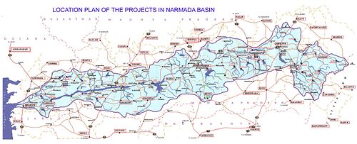

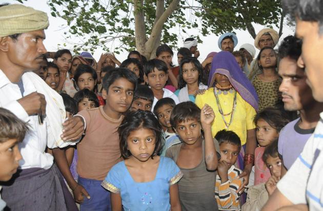

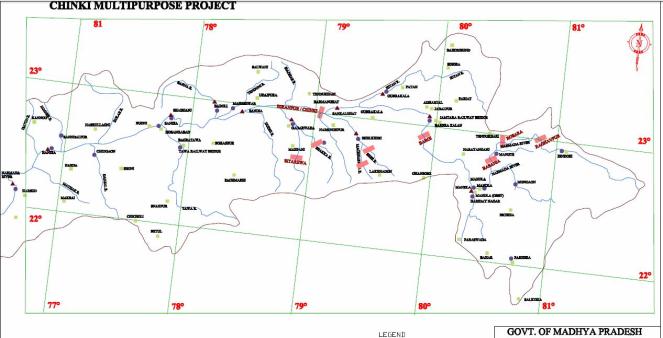

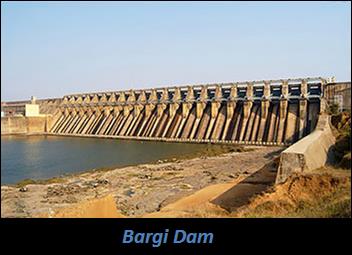
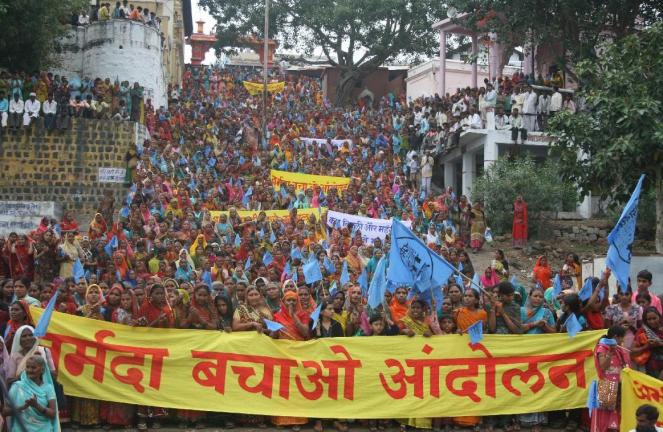


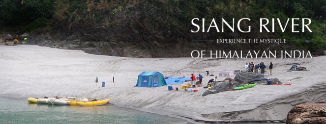


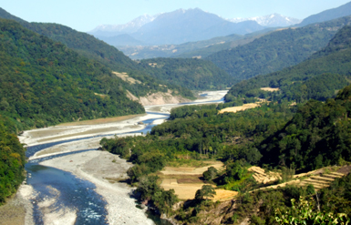


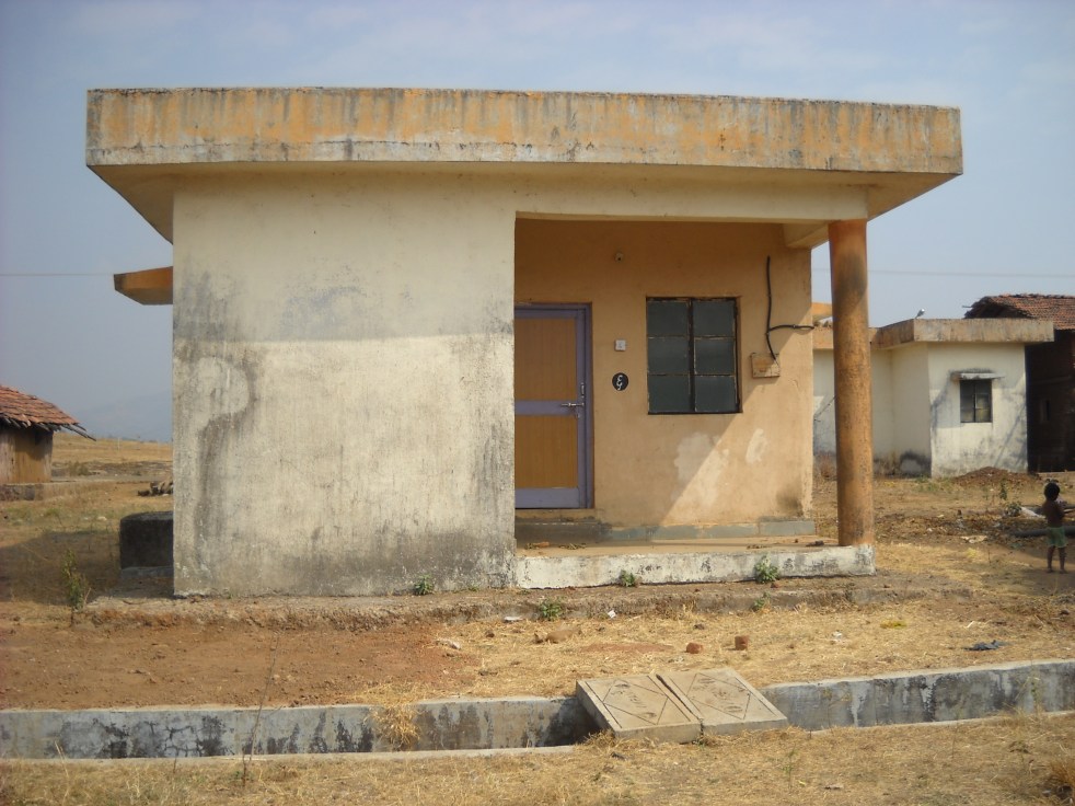
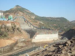


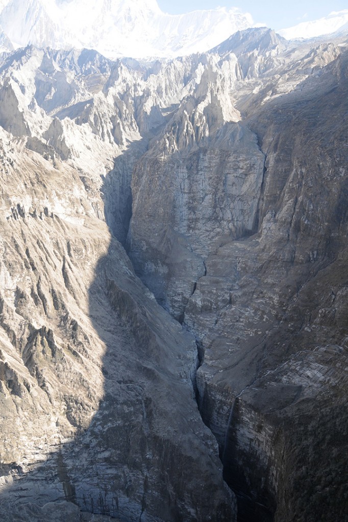
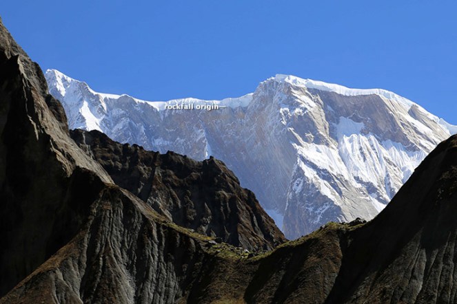
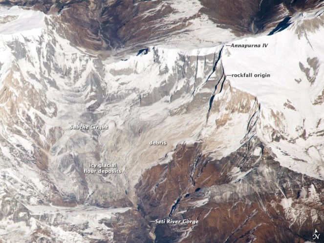
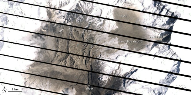

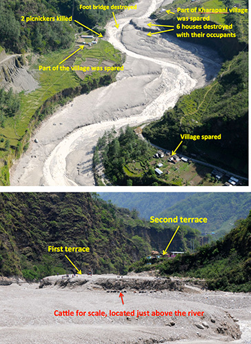

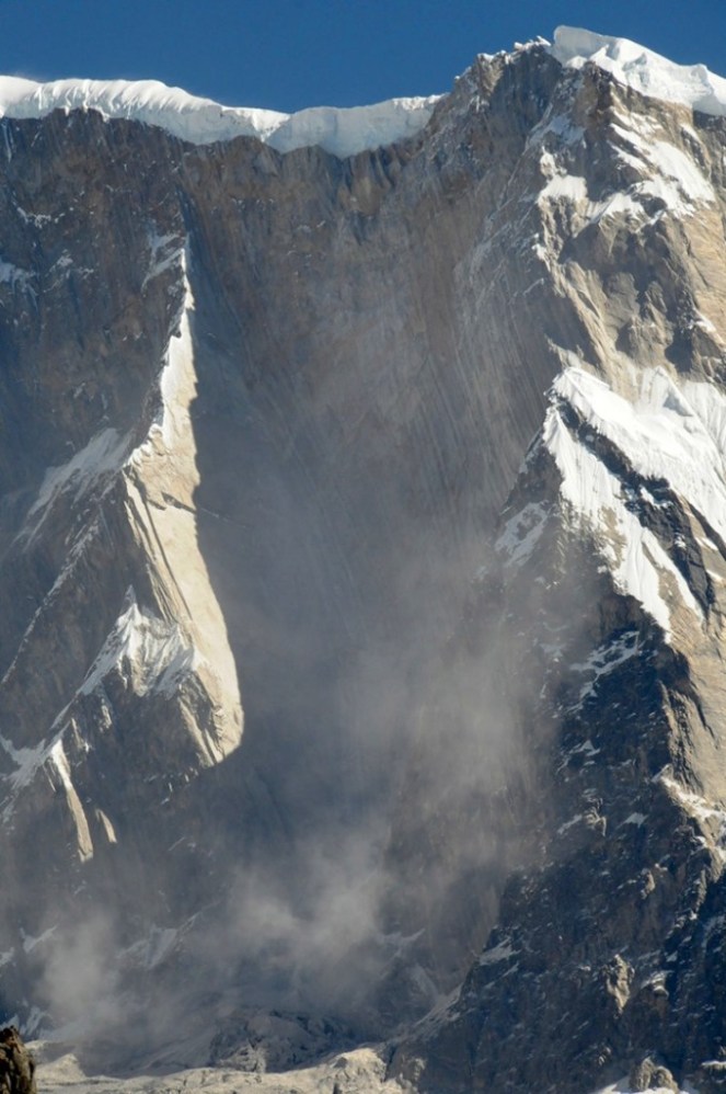


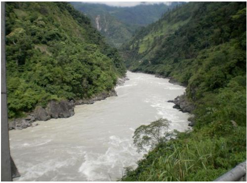
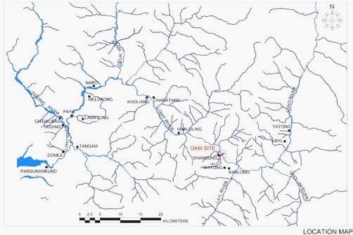


