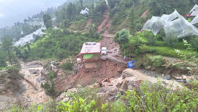
(Feature Image: Seraj valley in Mandi district of Himachal battered by extreme weather events in July 2025)
Well known environmentalist Manshi Asher through the following article is giving a very important message that everyone, particularly Judiciary needs to listen and act upon. While higher judiciary is rightly highly respected, its track record on acting on environmental issues is far from satisfactory and leaves a lot to be desired.
While it is accepted that judiciary cannot encroach on government’s domain related to policy matters, even on eminently justiciable issues fully in legal domain, the judiciary has failed to act on crucial matters and cases as Asher rightly argues. She gives numerous examples in her article, and many more such examples can be given. The cases related to fraudulent EIAs, unimplemented EMPs including muck dumping plan or environment flows or compensatory afforestation or catchment area treatment plans or early warning systems or disaster management plans or assessment of alternatives or proper operation of dams during floods or even ensuring just resettlement and rehabilitation or ensuring genuine public consultation process or ensuring independent persons on appraisal committees or ensuring there is no conflict of interest or ensuring proper treatment of effluents before their release into river are some such examples of matters that are eminently legal matters on which the higher judiciary has failed to act. The dire state of our rivers, the state of Himalayas and western ghats are some clear evidence of such failures of judiciary.
One only hopes the judiciary will take all this in right spirit, listen and take corrective actions. As Asher says, the ecology is the habitat for millions of people and it is the duty of the courts to ensure fundamental rights of these millions of people.
People in the Mountains Need Disaster Justice, Not Sermons on Environmentalism
Manshi Asher: The Supreme Court has performed environmental concern, but not acted when and where it matters most.
The immediate context was the case of Pristine Resorts Pvt. Ltd. vs State of Himachal Pradesh, where the business enterprise had challenged the government’s decision to classify Shri Tara Mata Hill in Shimla as a “Green Area”, thus barring new construction and tightly restricting alterations. The Supreme Court’s accompanying comments in its order of July 28, 2025 referred to disaster drivers in the form of the destructive footprint of hydropower projects, unscientific road construction, deforestation and unregulated tourism in Himachal Pradesh.
Now, the July 28 order, for all its righteous text, ends with no substantive directive that interrupts or even interrogates the ongoing infrastructural assault on the region. It doesn’t halt any projects. It doesn’t question the environmental clearances routinely issued by the Ministry of Environment, Forest and Climate Change (MoEFCC). It doesn’t demand accountability from the National Highways Authority of India (NHAI), the numerous private hydropower corporations who have violated dam safety laws, or the central and state agencies complicit in ignoring geological warnings. Instead, it offers a candid acknowledgment of the disaster but refuses to name the beneficiaries, the defaulters or the (lack of) regulatory processes by which it was produced, particularly the precedents set in the judicial realm.
The Himalaya are not just a scenic backdrop or a strategic frontier. They are home to millions of people who live with the consequences of policies made in the corridors of power. If Himachal or any Himalayan state vanishes, what will be the fate of the downstream states? To preach environmentalism to the dispossessed and distressed, while sparing those who profited from destructive development or those who remain apathetic to the crisis, is what makes these disasters bigger and worse.
HYDROPOWER PROJECTS
Sept 2025: 5 die when Kadana dam water release floods Gujarat Hydro project On Sept 4, 5 workers died when water released from Kadana Dam on Mahi River in Gujarat entered the under repair 12 MW Ajanta power house about 20 km downstream from Kadana dam. An FIR for death due to negligence has been filed.
4 HEPs of Kishtwar declared High Risk A comprehensive risk assessment has declared four hydroelectric projects in Kishtwar district as “high risk” due to the growing threat of Glacial Lake Outburst Floods (GLOFs), putting lives, infrastructure, and investments worth tens of thousands of crores of rupees at stake. The GLOF Management Plan for Kishtwar 2024-25 warns that the tehsils of Padder, Machail, Dachhan, Marwah, and Warwan face the greatest danger because of their proximity to Himalayan glacial lakes. A sudden breach could unleash flash floods that would devastate mountain villages, wash away bridges and roads, and cause irreparable damage to the fragile ecosystem of the Chenab Valley.
At the centre of concern are four flagship projects of Chenab Valley Power Projects Private Limited (CVPPL) – Pakal Dul, Kiru, Kwar, and Dangduru. “Rising water levels or potential dam breaches could threaten project infrastructure, disrupt operations, and increase downstream flood risk,” the report said. The total sanctioned cost of the three projects – Pakal Dul, Kiru, and Kwar – exceeds Rs 22,535 crore.
Pakal Dul cost is Rs 12,669.67 crore and involves constructing India’s tallest concrete-face rockfill dam on the Indus system. 624 MW Kiru, estimated at around Rs 5300 crore, is slated for commissioning in mid-2025. The 540 MW Kwar project cost is Rs 4526 crore. The Dangduru project, still in the planning stages, has no official cost released so far.
Said a senior official in the J&K Power Development Department (PDD). “We are working on mitigation measures, including glacial monitoring, early warning systems, and strengthening of dam safety mechanisms, so that risks can be minimised without compromising energy security.”
Environmentalists argue that unchecked construction in such an ecologically fragile zone could amplify disaster risks. The report itself highlights that a dam breach or uncontrolled flood wave would not only damage project sites but also endanger downstream towns and threaten livelihoods across wide swathes of Jammu and Kashmir.
HP HC admits petition questioning no need for EC for HEPs below 25 MW capacity The Himachal Pradesh High Court has issued notices to Cenral Govt, Ministry of New and Renewable Energy Sources and HP Govt on a petition challenging the notification that hydropower projects below 25 MW do not need environment clearance. Next hearing on Oct 29.
BBC Video report about China’s Medog dam and India’s SUMP In this 15 minutes Video Ground Report (HINDI) “India-China दोनों इस नदी पर बना रहे Dam, इससे किन्हें ख़तरा, क्या बोले लोग Ground Report (BBC Hindi)” on China’s Medog dam on Yarlung Tsnagpo HEP in Tibet and India’s proposed SUMP on Siang river. It quotes SANDRP coordinator (see from 9.58 to 10.56 and 13.43 to 14.36).
DAMS
Ghose Commission blames KCR for Kaleshwaram project lapses Recommending that the state govt take appropriate action against the KCR in accordance with law, the one man Justice (Retd) PC Ghose commission observed that it was ‘conclusively established’ that the then CM’s direct involvement and minute directions in the planning, construction and operation of the three barrages of Kaleshwaram project — Medigadda, Annaram and Sundilla — were the root cause of irregularities and distress.
“The then chief minister KCR took every decision upon himself. In all aspects of the construction of these barrages, beginning with conceptualising the Kaleshwaram project under the guise of re-engineering the Dr BR Ambedkar Pranahitha-Chevella Sujala Sravanthi Scheme, he personally intervened. This included entrusting consultancy services to WAPCOS on nomination, proceeding without its final Detailed Project Report (DPR), directing preparation and approval of estimates without cabinet sanction, ordering impound of water, and relaxing contract conditions to favour agencies unduly,” the Ghose commission said. The state govt has tabled the 650-page report in the assembly on Aug 31 after the cabinet earlier accepted the report of the commission submitted the report on July 31.
Apart from KCR, the commission recommended action against former ministers T Harish Rao and Eatala Rajender, as well as against engineering officials associated with administration, quality control, operations and maintenance, designs, and the Kaleshwaram corporation.
Kaleshwaram probe to be handed over to CBI The “Inter-state entities, various departments and agencies of the Central and State Governments are involved in this project. Since Central Public Sector Undertakings like WAPCOS and financial institutions like PFC and REC are involved in the design, construction and financing of the project, the government decided to hand over this case to the Central Bureau of Investigation (CBI). Hence, the House took a decision to hand over the investigation of the Kaleshwaram project case to the Central Bureau of Investigation”, said Telangana Chief Minister Revanth Reddy.
Ghose Commission finds Kaleshwaram Unviable The PC Ghose commission also found the three barrages of Kaleshwaram unviable to continue and stated that the irrigation department now faces a power dues burden of Rs 9,735 crore to the power department, as it consumed 8,450 MW, compared to 3,400 MW required for the Pranahita Chevella project.
Claiming that KLIS did not bring any additional crop area under irrigation, Telangana Water Resources Minister Uttam Kumar Reddy said the state recorded a record harvest of 26.1 Mil Tonnes in 2024-25, after the barrage collapsed and with no net water usage for crops. In contrast, when Kaleshwaram was operational, paddy harvests were 18.6 MT in 2021-22, 23.8 MT in 2022-23, and 25.3 MT in 2023-24, he said during debate on the 665 page report in the Telangana assembly on Aug 30. He said: The net water available after evaporation losses was only 114 tmc ft and of which only 101 tmc ft water was used. The new ayacut created was less than 1 lakh acres and stabilisation too less than 1 lakh acres.
1. Oju Hydro-Electric Project (2220 MW) in an area of 750.06 Ha located at Village Reddi, Yaja, Gumsing etc, Sub District Taksing, Limeking Circle, District Upper Subansiri, Arunachal Pradesh by M/s Oju Subansiri Hydro Power Corporation Pvt Ltd – Environmental Clearance
2. Munjari Irrigation Project (CCA: 11575 Ha) in an area of 1043.089 Ha located at Village Rinjha, Baroda, Awda etc, Sub District Badoda and Karahal, Sheopur, Madhya Pradesh by M/s Madhya Pradesh Water Resources Department – Environmental Clearance
3. Kumbhe Open loop Pumped Storage Project (1100 MW) in an area of 151.05 Ha at Village Kelgan, Kumbhe, Manjurne & Chach, Sub- district Mangaon, District Raigarh, Maharashtra by M/s NTPC Limited – Terms of References
4. Medium Irrigation Project to Various Panchayats of Jawalamukhi (CCA: 2590 Ha) in an area of 17.89 Ha Village Salasi, Kotla, Kotu Dhorian (869) and etc., Sub-district Nadaun, Jawalamukhi, Khundian & Dera Gopipur etc., District Hamirpur & Kangra, Himachal Pradesh By Executive Engineer, Jal Shakti Vibhag Division – Terms of Reference
5. Chittamvalasa Closed loop Pumped Storage Project (1800 MW) in an area of 318.6Ha Village Devarapalli, Diguvasobha, Dumbriguda, Majjivalasa & Vachanarangini, Sub-district Araku Valley, Ananthagiri & Hukumpeta, District Alluri Sitharama Raju, Andhra Pradesh by M/s Navayuga Enegineering Company Limited – Terms of Reference
6. Gujjili Closed loop Pumped Storage Project (600 MW) in an area of 294.22 Ha Village Tangulaguda, Satapi, Tangalam, Bhimavaram & Chippapalli etc., Subdistrict Araku Valley, Pachipenta & Ananthagiri, District Alluri Sitharama Raju & Parvathipuram Manyam, Andhra Pradesh by M/s Navayuga Enegineering Company Limited – Terms of Reference
Env Audit Rules 2025 for Env Compliance Main Features of Environment Audit Rules, 2025
Auditors to be Certified and Registered by MoEFCC notified Environment Audit Designate Agency (EADA).
EADA to be responsible for certification and registration of EAs, monitoring their performance, take disciplinary action, facilitating capacity building, maintaining online register.
Certification of Environmental Auditors to be based on either scrutiny of their qualification and experience or by conducting an exam.
Auditing to be undertaken only by Registered Environment Auditors.
The assignment of REAs to specific project entities shall be done by a random assignment method.
REAs responsible for compliance evaluation and related activities of sampling, analysis, compensation calculation, verification under Green Credit Rules, audit under waste management rules, and under various other environment and forest related legislations.
REAs may also undertake auditing assignment by the PP including for verification of self compliance report.
Key Regulatory Stakeholders under the Rules:
Certified Environment Auditor: Individuals who qualify through either Recognition of Prior Learning (RPL) or the National Certification Examination (NCE).
Registered Environment Auditor: Those certified individuals officially registered to perform audits.
Environment Audit Designated Agency (EADA): The body responsible for certification, registration, oversight, and training of auditors.
Ministry of Environment, Forest and Climate Change; Oversee the implementation of the Rules and issue necessary guidelines from time to time.
CPCB/SPCB/ROs: To continue with their existing role of inspection and verification, as and when required and to assist MoEFCC in overseeing the implementation of the Rules.
Oversight Mechanism:
A Steering Committee, led by an Additional Secretary from MoEFCC, along with representatives from relevant divisions and regulatory bodies, monitors progress, addresses implementation challenges, and suggests reforms.
Expected Outcome from the Initiative:
Strengthening Environmental Compliance- These rules aim to ensure independent third-party verification of environmental performance, making compliance more credible, measurable, and enforceable.
Aligning with Emerging Environmental Frameworks- The rules are designed to support and integrate with various other environmental instruments like Green Credit Programme, Eco-mark Certification and Extended Producer Responsibility under waste rules.
Enhancing Regulatory Capacity- By creating a pool of trained and certified professionals, the burden is shared, allowing the government to focus on high-risk enforcement and policy improvement.
Improving Transparency, Accountability and Ease of Doing Business- By introducing a certified and randomly assigned auditor system, the government aims to eliminate conflicts of interest, promote unbiased assessments, and build public and institutional trust in audit outcomes, while promoting Ease of Doing Business.
Data-Driven Environmental Governance- Regular audits will provide systematic, verifiable, and digitized data on emissions, discharges, waste, and resource use. This supports better decision-making, public disclosure, and targeted interventions.
Proactive Risk Management- Audits help detect non-compliance early, enabling timely corrective action and preventing environmental damage.
Debadityo Sinha, lead –– climate and ecosystems at Vidhi Centre for Legal Policy, said the “entire framework risks becoming a facade because its credibility rests wholly on whether the EADA can function with genuine independence and rigor. While the government claims these rules will ease business and address the resource deficit of regulators, in reality, they merely shift the burden and accountability of environmental compliance to a new industry of private auditors under yet another institution, the EADA,” he said. “Unless this body proves it can hold auditors accountable without bending to political or industry pressure, the system will only weaken public regulators further while giving the appearance of compliance.”
DAM SAFETY
Hirakud dam cracks and cavity detected, needs urgent repair Sudhir Kumar Sahu, additional chief engineer, Hirakud Dam Circle, has said that while the dam’s overall strength remains good, superficial cracks and cavities have been identified upstream of the reservoir.
DAM FLOODS
Punjab Floods: Role of Bhakra, Pong and Ranjit Sagar Dams This analysis of operation of Bhakra, Pong and Ranjit Sagar Dams during Aug-Sept 2025 Punjab floods shows that the wrong operation and sub optimal power generation from these dams played a significant role in worsening the Punjab Flood disaster. The analysis also shows the steps we need to take to avoid repeated recurrence (this had already happened earlier in 1978, 1988 and 2023) of this disaster. Please Read, Share. An edited version of this report was first published here.
Bhakra level up 4 ft in 36 hrs The water level in the Bhakra dam in Himachal Pradesh has risen by over 4-ft in the past 36 hours. On Sept 2 morning, the water level touched 1676.78 ft, it was 1672.68 ft afternoon on Aug 31. Inflows are upto 1.9 lakh cusecs.
Water Enters Bhakra Left Bank Power house Panic gripped authorities at Bhakra Dam on Aug 31 night after water entered the left bank power house following heavy rains in the adjoining hills. According to BBMB Chief Engineer (Power) Jagjit Singh, water began seeping into the galleries of the power house but was promptly detected by on-duty staff, who immediately initiated pumping operations, thereby preventing major damage. He further added that roads to both the right and left bank power houses have been blocked due to landslides, and efforts are currently underway to restore access.
Punjab floods of 1988 and 1993 This report provides an overview of Punjab floods of 1988 and 1993 that lead to flooding of 18% and 19.4% land of Punjab in those two years.
Human factors that have contributed to the disaster: poor management and lack of cleanliness of drains, canals and choe, choked natural waterways, weak and poorly maintained dhussi bandhs, lack of green cover, illegal mining, and deforestation, illegal and mindless constructions in floodplains and riverbanks— have maximised the destruction brought in by floods.
2023 Floods: The study “Punjab Floods 2023: Causes, Impacts and Learnings” by Punjab Agricultural University (PAU) in Ludhiana said: “Climate change-induced climatic extremes are becoming frequent with the passage of time. The incessant rainfall in Himachal from July 7-11, 2023, was 436% above the normal, and caused heavy flooding in the downstream tracts of Punjab. The overflowing water entered Punjab through the Beas, Ghaggar and Sutlej. Nearly 2.21 lakh hectares of cropped area, mainly under paddy, got damaged”. However, wrong operation of dams played a major role here as SANDRP wrote.
Sep 3: Bhakra at 1678 ft, releases to increase to 75000 cusecs Bela villages are those located inside the natural flow of the Sutlej river. Most of these villages have lost connectivity due to the increased flow in the Sutlej river. Such villages in Ropar dist are to be evacuated. Inflows to Bhakra dam in the morning were 86822 cusecs. The water level in the Pong Dam reservoir was at 1,393.19 feet. The inflows in Pong Dam were 160,183 cusecs, the outflows were 79,637 cusecs.
4 days on, Pong water level above danger mark According to the BBMB, the Pong reservoir level touched 1,394.15 feet on Sept 3, the highest level recorded this season. On Sept 2, the level stood at 1,391.55 feet; on Sept 1, 1,390.52 feet and on Aug 31, 1,390.94 feet. At 1 pm on Sept 3, inflows were 1,55,261 cusecs. BBMB engineers operated six power units, releasing 16,988 cusecs through turbines, while opening spillway gates to discharge 62,949 cusecs. The combined outflow stood at 79,937 cusecs.
URBAN FLOODS
Why Urban Planning fails against floods What we are witnessing—from Gurugram’s flooded boulevards to Delhi’s crumbling flyovers—is the slow, visible erosion of a planning culture that treats cities as finished products rather than evolving organisms. It is a failure of imagination. A bridge might be designed to last 50 years, a water pipeline a century. But design life is a fiction if maintenance is absent. We are quick to build and quicker to inaugurate, but maintenance lacks spectacle. And so it is neglected. Urban resilience will be defined by whether our cities can pause, reflect, and respond to change — intellectually, institutionally, and spatially. The most enduring cities will not be those that dazzled on day one, but those that continue to function on day thousand.
FLOODS
Unusual downpour leads to flash-floods in Ladakh Leh in Ladakh has recorded its highest monthly rainfall in the past 52 years, with the Meteorological Centre Leh reporting 80.2 mm of rain in August 2025. The figure far surpasses previous records since 1973, marking an exceptional spike in precipitation for the cold desert region known for its arid climate. According to the Met Centre Leh data, the earlier highest records stood at 46.4 mm in 1995 and 45.2 mm in 2006.
Sonam Lotus, director, Meteorological Centre Leh, UT Ladakh said, “When we talk about the highest rainfall in 24 hours, it was recorded in 1933. The recent August rainfall (80.2 mm) was continuous and incessant, whereas in 1933, 51.3 mm was recorded in just 24 hours. In August this year, the highest rainfall received in a single day was 37 mm in Leh, while Kargil recorded 33 mm in 24 hours. Right now, the moisture is coming from the Bay of Bengal and there is also a supplement from western disturbances. These bring westerly-driven moisture from the Arabian Sea, the Black Sea, the Caspian Sea and even the Red Sea. What you see today is the combined effect of the monsoon and western disturbances”.
“The water that flows in our streams comes from glaciers and permafrost beneath the mountains. As these sources shrink, the consequences for our future will be severe,” he added. “The most dangerous situation is when you have hot and humid weather and suddenly a localised shower takes place. It can wash away homes within minutes. Such events are very difficult to predict and even early warning is often not enough because people have very little reaction time,” he said.
He further said, “The timing and duration of rainfall matter a lot and this recent spell in August was not ideal for Ladakh as farmers were in the middle of harvesting their crops. Such rainfall has both positive and negative impacts. On the positive side, it helps recharge groundwater. But on the negative side, it has caused mud houses to collapse, uprooted trees and caused other adverse effects, especially from an economic point of view.” The unusual downpour has led to flash floods across Ladakh, soil erosion and damage to infrastructure, as the region’s fragile ecology and traditional housing structures are highly vulnerable to heavy rains.
Flood control plans could open doors to unregulated mining Himachal Pradesh is contemplating a dredging and river-training policy to control floods and has sought environmental exemptions from the centre for it. However, experience from its neighbouring state Uttarakhand shows that blanket exemptions and relaxations under such a policy may facilitate illegal and rampant mining, contributing to the worsening of disasters. Instead, hill states need a case-by-case, scientific approach towards the dredging of their rivers and a holistic and multidisciplinary policy with involvement of local communities to control floods, experts say.
In 2020, the state of Uttarakhand increased the depth for riverbed mining from 1.5 metres to three metres. The state government justified the decision by referring to the 2016 and 2020 guidelines for sustainable sand mining, as well as their monitoring and management by the Centre. The guidelines prescribed that mining depth should be restricted to three metres. “But that was the maximum depth allowed. A case-by-case approach could have been applied while allowing mining in riverbeds. Anyhow, in the mountain terrain of Uttarakhand, the central guidelines should be applied with caution. A credible district survey report (DSR) and replenishment study must be the basis of any such exercise,” said Bhim Singh Rawat, Associate Coordinator at SANDRP. “Effectively, dredging in the garb of disaster prevention became a way to allow unabated mining in riverbeds, and done in an unscientific and unsustainable way, it only contributed to flooding and disasters,” said Rawat.
HFL BREACH
Jammu & Kashmir: Rambaira river in Indus basin at Watci site in Pulwama district has crossed its HFL 1593.33 meter dated 22.02.2022 at 11:00 hour on 03.09.2025. The flood level in the river increased by 4.19 meter in 5 hours from 1590.65 meter at 09:00 hour to 1594.84 meter at 14:00 hour on 03.09.2025.
Jhelum river at Khanabal site in Anantnag district has again crossed HFL 1594.84 meter attained last week on 27.08.2025 at 12:00 hour on 03.09.2025. The flood level in the river at the site increased by 5.09 meter in 14 hours from 1590.06 meter at 01:00 hour to 1595.15 meter at 14:00 hour on 03.09.2025.
Jhelum river at Fatehpora site in Ganderbal district has crossed HFL 1585.2 meter dated 26.06.2023 at 12:00 hour on 03.09.2025. The flood level in the river increased by 2.56 meter in 8 hours from 1583.07 meter at 07:00 hour to 1585.63 meter at 15:00 hour on 03.09.2025.
Vishow river at Arwani site in Anantnag district has crossed HFL 1593.81 meter dated 22.06.2022 at 10:00 hour on 03.09.2025. The flood level in the river increased by 5.93 meter in 16 hours from 1588.95 meter at 24:00 hour on 02.09.2025 to 1594.88 meter at 16:00 hour on 03.09.2025.
River Chenab at Bardoh site in Jammu has crossed its HFL 282.455 meter dated 15.08.2024 at 07:00 hour on 03.09.2025. The flood level in the river increased by 4.39 meters in 26 hours from 279.005 meter at 08:00 hour on 02.09.2025 to 283.395 meter at 10:00 hour o 03.09.2025.
River Doodhganga at Kralpora site in Badgam district has crossed its HFL 1594.22 meter dated 22.06.2022 at 10:00 hour on 03.09.2025. The river has attained a new HFL 1594.3 meter there at 12:00 hour which is 0.08 meter higher than old HFL at the site. The flood level in the river increased by 1.39 meter in 6 hours from 1592.91 meter at 06:00 hour to 1594.3 meter at 12:00 hour on 03.09.2025.
Lidder river at Ganeshpura site in Anantnag district has missed breaching its HFL 1871.78 meter dated 28.08.2016 by 0.03 meter as the peak flood level at the site was 1871.75 meter at 07:00 hour on 03.09.2025. Present flood level is 1871.4 meter at 21:00 hour on 03.09.2025.
Chenab river at Dharmari site in Reasi district has missed crossing HFL 585.04 meter dated 28.07.2022 by 0.05 meter. The peak flood level recorded at the site was 584.99 meter at 12:00 hour on 03.09.2025.
Haryana: Yamuna River at Manjhawali site in Faridabad has crossed its HFL 194.18 meter dated 14.07.2023 at 11:00 hour on 05.09.2025.
Yamuna river has at Mohna site has marginally crossed its HFL 192.44 meter attained on 14.07.2023 at 19:00 hour on 05.09.2025.
Yamuna at Shergarh site in Mathura district has crossed HFL 177.32 meter dated 16.07.2023 at 01:00 hour on 07.09.2025.
River Yamuna has also crossed HFL 166.22 meter dated 17.07.2023 at Gokul barrage site in Mathura at 08:00 hour on 07.09.2025. Interestingly, in 2023 the river had crossed HFL 116.17 meter which was set on 26.09.2010.
Yamuna has breached HFL 133.81 meter dated 20.07.2023 at Bateshwar site in Agra at 07:00 hour on 07.09.2025. Interestingly the flood has already entered temples and inundated the road adjoining river there but the warning level and danger level at the site are higher than the HFL.
RIVERS
Climate Change impact on Ganges Headwaters A team of researchers from the Indian Institute of Technology Indore and partner institutions has reconstructed four decades of discharge from the Gangotri Glacier System (GGS), offering the clearest picture yet of how snow, glacier ice, rainfall, and groundwater each contribute to the river’s flow, and how these proportions have shifted under a warming climate.
Published in the Journal of the Indian Society of Remote Sensing, the study deployed the high-resolution Spatial Processes in Hydrology (SPHY) model, calibrated with rare field discharge measurements (2000–2003), satellite-derived glacier mass balance data (2000–2019), and MODIS snow cover maps (2002–2020). The result is a 41-year hydrological reconstruction — the longest and most detailed yet for the Gangotri catchment. The analysis found that snowmelt is the dominant contributor, supplying 64 per cent of annual flow, followed by glacier melt (21%), rainfall-runoff (11%), and baseflow (4%). On average, the glacier system discharges 28 cubic metres of water every second into the Bhagirathi.
“Over the last four decades, the composition of flow from the GGS is changing due to climate change, and this study offers the most detailed picture yet of how those changes have unfolded,” said lead author Parul Vinze, a PhD scholar at IIT Indore’s Glaci-Hydro-Climate Lab. While snowmelt remains the backbone of the system, its contribution has been declining over time, even as rainfall-runoff and baseflow have gradually increased. This subtle rebalancing of the basin’s water sources points to a changing climate regime.
“After 1990, the discharge peak in the Gangotri system shifted from August to July, linked to reduced winter precipitation and earlier summer melting,” Vinze explained. “The seasonal timing of flows is just as important as their volume, especially for downstream users.”
Statistical analysis revealed that annual discharge from the GGS is strongly controlled by summer precipitation (correlation coefficient r = 0.62) and winter temperature (r = 0.52). Simply put, wetter summers boost runoff, while warmer winters reduce snow accumulation — a double pressure on snow-fed systems. “The Gangotri system is snowmelt-dominated, unlike the Indus basin which is more ice-dominated. That makes it especially vulnerable to shifts in snowfall and temperature patterns,” said Dr Mohd. Farooq Azam, senior author of the study, Associate Professor at IIT Indore and Senior Intervention Manager – Cryosphere at the International Centre for Integrated Mountain Development (ICIMOD).
The decadal breakdown tells a striking story. From 1980-1990, snowmelt contributed nearly three-quarters of annual discharge. By 2001-2010, that share had dropped to just over half, before rebounding somewhat in the last decade due to increased winter precipitation. Rainfall runoff jumped from just 2% in the 1980s to as high as 22% in the 2000s. “The Ganga may not be as meltwater-dependent as the Indus,” Azam said. “But at high elevations, where hydropower and irrigation systems rely on steady flows, these changes are already visible. If ignored, the risks will only intensify.”
Another notable finding is the shift in peak discharge. In the 1980s, August flows were highest. Since the 1990s, July has emerged as the new peak month — an advance of nearly a month. “Seasonality of flows from glacier-fed catchments is crucial,” Dr Azam said. “The observed changes in meltwater seasonality and runoff volume could severely affect hydropower generation and irrigation at higher elevations, even if impacts downstream are buffered by monsoonal rainfall.”
URBAN RIVERS
CEC asks stoppage of tree felling in Riparian areas in Pune The Supreme Court-constituted Central Empowered Committee (SC-CEC) has on Aug 21 written to the Maharashtra chief secretary seeking directions to Pune and Pimpri Chinchwad civic bodies to halt all proposed tree felling in the riparian zones of Mula, Mutha, Mula-Mutha, Indrayani and Pavana water bodies for the riverfront development (RFD) work. The panel has sought such directions till the SC order of March 4 — regarding identification and demarcation of deemed forest areas by a state-appointed expert committee — is “implemented in toto” and a compliance affidavit submitted to the apex court.
City-based NGO Jeevitnadi, along with Ecological Society, Nisargsevak and Devrai Foundation, had written to the SC-CEC on Aug 18. It said there was a plan to cut trees in the deemed forests located in and around the riparian zones of the Mula, Mutha, Mula-Mutha, Indrayani and Pavana rivers. The panel took note of the same while writing to the state chief secretary.
Most DDA Yamuna floodplain parks submerged; recovery may take months Nearly all major riverfront and biodiversity projects developed by the Delhi Development Authority (DDA) along the Yamuna floodplains now lie under water, with the swollen river surging well above the danger mark for the past four days.
Officials said the scale of destruction will only be known once the water recedes, but vast stretches of newly planted landscape – lawns, ornamental shrubs, saplings and riverine grasses – are feared lost. Walkways, sculptures, parking lots and cycle tracks are also submerged, reducing ambitious floodplain redevelopment projects to waterlogged wastelands.
Among the worst-hit is the Amrut Biodiversity Park, inaugurated in March this year across 90 hectares on the eastern bank near the Delhi–Meerut Expressway. Home to nearly 14,500 trees of diverse species, 18,000 shrubs and more than 321,000 grasses, the park was fully submerged by Wednesday evening. Only the canopies of the tallest trees were visible above the waterline. Designed with landscaped lawns, pathways and concretised parking zones, the park now resembles a swamp.
Yamuna floods Noida’s luxury farmhouses As the Yamuna swelled on Sept. 04 morning, touching 200.6 metres at the Okhla barrage around 9am, floodwaters pushed into the plush farmhouses dotting the river’s floodplain, leaving swimming pools, banquet halls and manicured lawns underwater. The inundation has revived memories of last year’s record flood, when the river rose to 202.17 metres, forcing widespread evacuation and leaving behind trails of damage. For many caretakers and workers now marooned inside the compounds, the sight is unsettlingly familiar.
The floods have come days after the Allahabad High Court directed the Noida Authority and farmhouse owners to maintain a status quo in an ongoing dispute over alleged illegal constructions on Yamuna floodplain. The Sept 2 order followed a fresh petition by around 30 owners challenging demolition notices served by the authority, which has consistently maintained that these farmhouses violate environmental regulations in an ecologically sensitive zone.
The tussle dates to May 2022, when the authority launched its first demolition drive against what it called “illegal” farmhouses, citing a June 8 public notice that prohibited any construction in Yamuna and Hindon floodplains. That drive saw 124 farmhouses and three clubs razed. Since then, demolitions have continued in phases, even as owners sought relief. Twice – in June 2022 and May 2023 – the high court ordered interim status quo while objections were heard. More than 300 such objections were filed, but the authority reaffirmed its stance that no concession could be granted.
A new petition challenging the demolition was filed in March 2023. On May 1, 2023, the HC again asked both the sides to maintain the status quo. The latest petition, filed last month, has now been tagged with the earlier case, ensuring that all related issues are considered together.
GLACIERS
Over 400 Himalayan Glacial Lakes expanding, need vigorous monitoring: CWC “Arunachal Pradesh accounts for the highest number of expanding lakes (197), followed by Ladakh (120), Jammu and Kashmir (57), Sikkim (47), Himachal Pradesh (6) & Uttarakhand (5).”
HIMALAYAN DISASTERS
Where is the accountability Severe floods across India’s Himalayan states—Himachal Pradesh, Uttarakhand, Jammu & Kashmir—have once again exposed our fragile relationship with nature. In the wake of these disasters, The Tribune published a powerful piece titled “Dams, Negligence, and the Making of Himalayan Floods”, authored by environmental advocate Himanshu Thakkar.
In this exclusive interview, Thakkar delves deeper into the systemic failures behind these calamities—ranging from poorly planned dams to the Central Water Commission’s lapses and weak environmental oversight. As the article argues, negligence isn’t just a by-product of climate change—it actively shapes disaster outcomes, turning heavy rain into devastating floods.
Thakkar highlights how development projects in fragile Himalayan terrain, when managed improperly, fundamentally increase risk. He explains the urgent need to make dam operation data public, to update flood preparedness protocols, and to empower local communities and watchdogs to act pre-emptively.
Join us to unravel how regulatory failures, infrastructure mismanagement, and ignorance of environmental limits are contributing to recurring, avoidable disasters. If you believe in a resilient, flood-safe future for our mountains and rivers, hit Play, share, and let’s amplify the call for accountability.
The rain catastrophes in western Himalayas this year The disasters that have unfolded in the Western Himalayas in recent weeks are often seen as isolated incidents. But a deeper examination of climate patterns in the region and beyond reveals that a complex cocktail of broader forces are at play. Specifically, the confluence of warming temperatures in both the highest ranges of the Himalayas and in the Indian Ocean, particularly in the Arabian Sea, has been a key factor in the intensified rainfall. Climate experts and geologists note that unless the government takes these changing climate patterns into account, and draws up strategies to protect the region from their effects, vast numbers of people will continue to remain vulnerable to deadly forces of weather.
For now, experts suggest that there is very little to indicate the government is treating the problem on the scale that is needed. “On the contrary, we have made the Himalaya more vulnerable through road excavation, hydropower, pluralification of settlement along rivers, and tunnelling activity of railways, impacting its inherent fragility,” said Navin Juyal, a scientist who has worked on the long-term impact of climate change on the Himalayas.
SC says illegal felling of trees led to ‘unprecedented’ floods, landslides; seeks response from Centre, affected states The Considering the unprecedented landslides and flooding in states like Himachal Pradesh and Uttarakhand, the Supreme Court on Thursday sought the stand of the Centre, National Disaster Management Authority and others, and observed “illegal felling of trees led to the disasters.” Observing a balance ought to be struck between “development and environment,” a bench of Chief Justice B R Gavai and Justice K Vinod Chandran also issued notices to the Union Ministry of Environment, Forest and Climate Change, the National Highway Authorities of India (NHAI) as well as the governments of Himachal Pradesh, Uttarakhand, Jammu and Kashmir and Punjab.
“We have seen unprecedented landslides and floods in Uttarakhand, Himachal Pradesh and Punjab. From the media reports it is noticed that in the flood a huge number of wood was flowing along. Prima facie it appears that there has been illegal felling of trees. Thus issue notice to respondents,” the CJI said. The bench allowed advocates Akash Vashishtha and Shubham Upadhyay, appearing for petitioner Anamika Rana, to serve the notice and the copy of the petition at the central agency. Hearing after two weeks.
Artificial lake formed in Lippa Flooding in Pejar Khad in Lippa of Kinnaur district of Himachal Pradesh has created a lake creating flooding threats for houses and the Bailey bridge. According to the information, on Sept. 04, there was a sudden flood in Pejar Khad of Lippa and a large amount of debris and stones also came with the flood, due to which the water could not drain out properly and a lake was formed there. Although there has been no loss of life due to this, but water and debris have entered the lower floors of the houses of about 5 people of the village, while apple plants of about 2 dozen gardeners, 5 irrigation canals and 2 drinking water sources have been damaged.
Landslides Form Two Lakes at Telgad Stream The recent landslide in Uttarakhand’s Uttarkashi has created two lakes near the mouth of the Telgad stream in Harshil, leading to concerns among locals. However, the SDRF has allayed their fears, saying the sizes of the lakes are not too large. The images of the lakes were captured by Army drones, prompting the administration to dispatch an SDRF team for a ground inspection to assess the situation.
Scientists believe it was due to the collapse of a glacier deposit, releasing a massive surge of water and debris into the Bhagirathi River. Dharali, once a bustling village in the Harshil Valley, known for its apple orchards and as a key halt for pilgrims to Gangotri, was buried under several feet of sludge and rubble within minutes. The incident’s scale has drawn comparisons to the 2013 Kedarnath disaster.
Syana Chatti lake (Aug. 31)After a rise in water level of the Yamuna river due to rains and blockage, the entire town has again submerged causing panic among the people. The bungalow of Garhwal Mandal Vikas Nigam along with this, the school campus is also filled with water. 03 Sept: Poclain operators risking their lives while channelizing Yamuna river at Syana Chatti to protect the town.
SOUTH ASIA
Bhutan India ink 570 MW Wangchhu HEP deal Bhutan Prime Minister Tshering Tobgay announced 570 MW Wangchhu Hydropower Project agreement between Adani Power Ltd. and Druk Green Power Corporation (DGPC).
REST OF WORLD
The Tyre Poison Nobody Talks About -When rain hits city streets, salmon die within hours. Scientists have traced the killer to a chemical hidden in every car tyre, one that turns stormwater into poison. New research shows this dust doesn’t just wipe out fish, it rides the air, lodges in our lungs, and is already reshaping ecosystems worldwide.
SANDRP
