
(Feature Image: Water pools (Dabras) formed in Ken (left) & Patne (right) rivers confluence in Pawai block, Panna district, MP. (Image taken during Ken River Yatra by SANDRP & Veditum)
This report is based on the experiences and understandings made during a thirty-three-day long walk along Ken River covered in three phases in June & October 2017 and in April 2018 by Bhim Singh Rawat, South Asia Network on Dams, Rivers and People (SANDRP), Delhi and Siddharth Agarwal, Veditam India Foundation, Calcutta.
The objective of the report is to share the observations with common public as we have done in past which can be seen here Part 1, Part, 2, & Part 3. In future also we would try to prepare similar reports to highlight the unexplored aspects and lesser-known stories of Ken river. The Hindi version of this report can also be seen here.
June 2017, First Phase
Ken is one of the cleanest rivers in India. During our walk, we got a chance to see and understand the ecological system of this river and the society settled on its banks closely. Usually, the mere thought of a ‘river’ creates a picture inside our mind of a continuously flowing stream from a certain source. Our walk started along the river with a similar imagination.
Standing at the confluence of Ken-Yamuna rivers at Chilla in Banda district of Uttar Pradesh the starting point of the walk on June 10, 2017, we saw the entire Ken’s course full of water giving impression of a mighty river. And crossing the river without a boat appeared impossible. In comparison, the Yamuna was seen flowing on left side with relatively less flow and a vast dry and sandy floodplain lying vacant next to it.
It looked as if the Ken were having more water than the Yamuna. But later on, we learnt that at the confluence, the Yamuna was hampering the Ken flows. Thus, causing stagnation of Ken’s waters. As per villagers during monsoon, the floods in Yamuna were able to confine the Ken flows for several kilometer upstream. The signs of eroding banks and some flood protection works done in patches for about 10 kilometers stretch of the Ken upstream from Ken Yamuna confluence were in a way affirming the villagers’ statements.
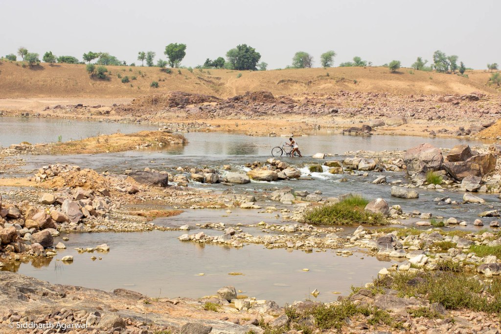
Assuming the Ken maintaining same sight, we continued walking. But hardly after 6-7 kilometers distance, the whole scenario changed. Unbelievably, the water level of the Ken turned completely shallow between Dighvat and Nari villages where locals were seen crossing the river comfortably on foot or by on cycles, motorcycles and tractors.
The river bed was rocky with much lower flows in sharp contrast to the bank to bank water stream noticed near Chilla. As evening drew closer, we rushed towards Pailani in search of a suitable place for night stay and could not think of reasons behind the drastic changes in river morphology.
Pailani is a small town that sits close on the left bank of Ken. In fact, a river meander covers the town from three sides. At the dawn, we noticed the river course full of water again except some shallow portion in the north.
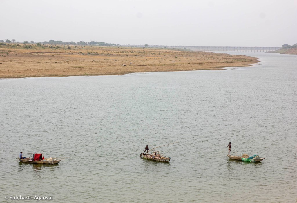
Moving up through Amlor, Alona, Khapatiha, Lukatra, Kanwara in Banda, we found the same scenario repeating itself. Large water pools stretching upto 5-6 kilometers resembling of a healthy river only to be disconnected by some 100-150 meters long dry, rocky patches where the river was easily crossable. In between, especially at the meandering, there were long-wide patches of sand (locally called Morang) and at some other places river banks and bed were dotted with stony out crop.
The river course was quite narrow outside Pathari village where we saw a teenager easily crossing the river by jumping over boulders on riverbed. The rustling sound of Ken as it rushed through rocks was a soothing site. One could not resist drinking river water and bathing in it. On the contrary, the river pool was so deep and long at Chatkan that villagers claimed it once had gangetic dolphins.
In Banda, we spent a full day exploring the Ken. Here for the first time the picture became a little clearer. We found the constant erosion had lowered a long stretch of left bank of the river by 20-30 feet near Kanwara.
The strangest thing was a spring (Jhira/Jhirna) oozing out of the soil mounds along left bank of river a little downstream of the Kanwara lift irrigation pump. The word Jhira is probably derived from Jharna meaning a spring.
Many locals were seen visiting the Jhira for potable water and bathing purposes in hot afternoon hours. The water was sweet in taste. There were about two or three smaller Jhiras nearby with comparatively less flows.
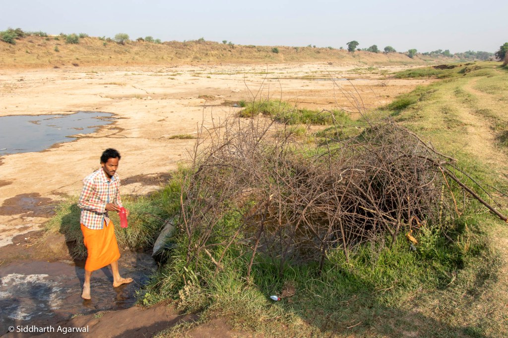
We then, remembered of having seen a similar frail water source seeping out by a dried up and dammed water course meeting Ken at Chatkan last day. It was shown to us by the riverbed farmers cultivating Bari (vegetables) there. A boatman also demonstrated us the traditional way Chui commonly used by riverine communities to get clean water by digging a hole in sandy riverbed.
About 2 kilometers long relatively dry river stretch upstream of Kanwara was filled up with small beautiful pebbles of different shapes and colors including the famous Sejar stones. We got to know that the Sejar stones were used in ornaments and some people used to collect it to earn livelihoods.
October 2017, Second Phase
Walking upstream, we found a large section of a river below the Banda old bridge completely covered by huge rocks with little flowing water visible downstream. It appeared that the river was able to top the rock formation only during the rainy season. After this, the cycle of deep pools and shallower riverbed kept repeating itself. At some places the entire river bank was rocky terrain and at other places filled with large sand parcels.
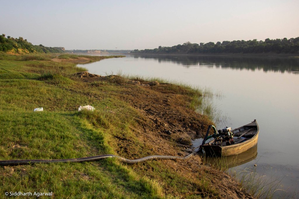
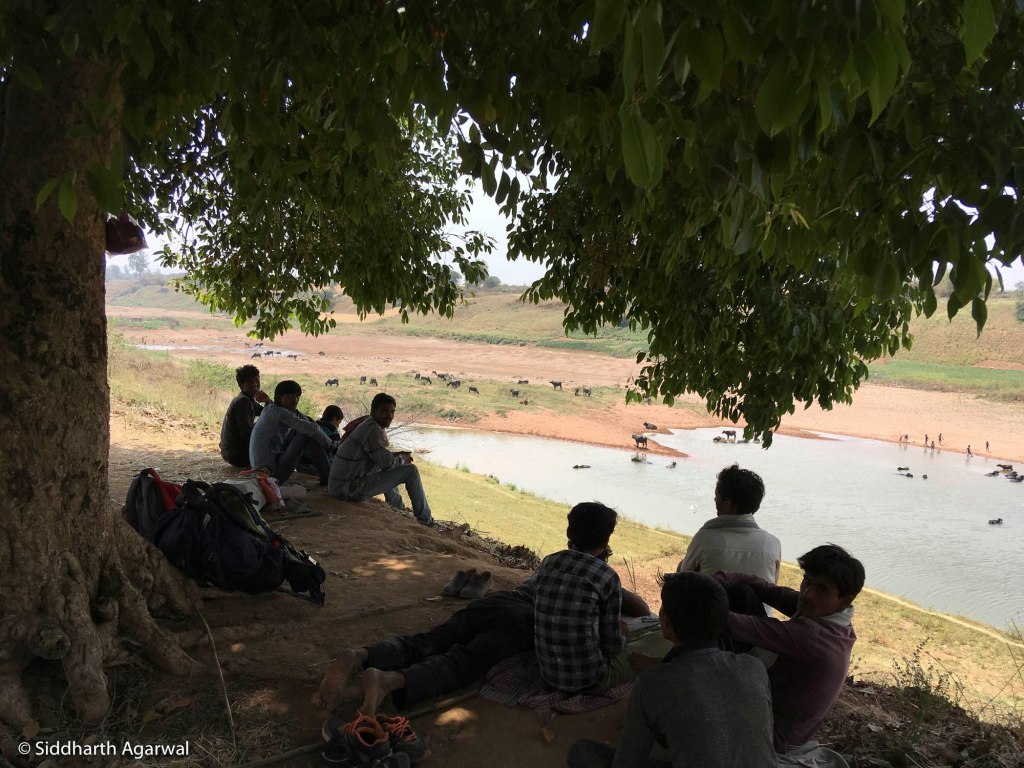
In fact, abundant aquatic life including turtles, fish were seen in and around these deep-water pools. Boats were moving in the river. Bari (vegetables) was being cultivated along its slopes. Crops on higher banks were being irrigated by drawing river water through diesel motors. The river supported rich diversity of vegetation including native trees. In some sense, these water bodies were giving the feel of a living river.
After walking almost half of the river length, we observed the river in more or less same form. Only the width and the amount of flowing water were getting progressively lesser. The banks were marshy at many places. The beauty of the Ken was at its peak around Donav (confluence of two rivers in local language).
One of the common questions we repeatedly asked our hosts during night stays and in conversation with people met while moving up, was whether they had seen the origin of the Ken and whether the river ahead had flowing water. Most of the people replied that they had heard of Kyan (not Ken) crossing seven mountains from its origin place. Regarding the second question, they answered that there would be a Dabra (water pool) ahead, then riverbed would turn waterless. They also said Kyan flows vigorously during monsoon.
It took us a long time to realize that people had named the water pools as Dabra and Dabri depending on length and amount of water they carried. We guessed that smaller water pools in riverbed stretching about half a kilometer were called Dabri and longer deep ones spreading over 5 to 6 kilometers river course as Dabra.
In fact, the geomorphological condition of the Ken is such that the river passes through the plateau region of the Vindhya Hills which is possibly the main reason behind rocky terrain along the river. Probably, natural depression and bowl formation in rock strata beneath riverbed were possibly reason for these unique water pools.
Moreover, groundwater in less or more amount keeps draining out into river due to gradient filling up the Dabri, Dabra with fresh water round the year enabling the river in maintaining some flows downstream in lean months. A few tributaries also bring in some inflows. It is due to these features that made the Ken a functioning river.
April 2018, Third Phase
This geomorphological difference was clearly visible at the Canyons of Raneh Fall and Pandav Fall on the river in Panna. The river was bone dry under the Pandvan bridge at Amanganj. And just some one and a half kilometer upstream, again a 3–4-kilometer long Dabra was seen spreading upto the confluence of Sonar River which ended up into a rocky, waterless Ken riverbed in upstream areas.
At Saptahi village of Amanganj, we saw some women fetching water from the river bank even though the river was totally dry. On reaching the spot, we found that a small stream of water was coming out at one place, which villagers called as Jhina (Spring). The water of the spring was sweet and cold. The villagers preferred to drink Jhina water in summer. Animals were seen drinking the same water accumulated in puddles in the river bed.
Walking upstream, similar Jhinas were seen at many places being used by locals to get water for drinking and bathing. At Dabras, villagers in groups were found enjoying bathing and swimming throughout the day.
Some half kilometer before the Tighra bridge, we witnessed another unique hydrological system of Ken outside Puraina village. Here a stunning Dabri in the middle of riverbed was separated by bone dry river stretches up and downstream it. There was a whole gathering of cattle herders under the trees on the left river bank.
In the conversation, people told us that the water was perennially coming out of ground from a particular point. Whenever pumping out caused a drop in water level, the Dabri got refilled itself in some time as if there were a natural tube well installed in the river bed, which they were calling as Jhina.
As per villagers, due to changing cropping pattern, Kyan was gradually turning seasonal as water from the river was continuously extracted for two-three months to irrigate the wheat crop. On reaching near Tighra bridge, we were amazed to see the groundwater coming out from the riverbed at few places. As we walked further in Powai, we witnessed a living river at Dabra, Dabri, Donav and flowless stony riverbed before and after these features.
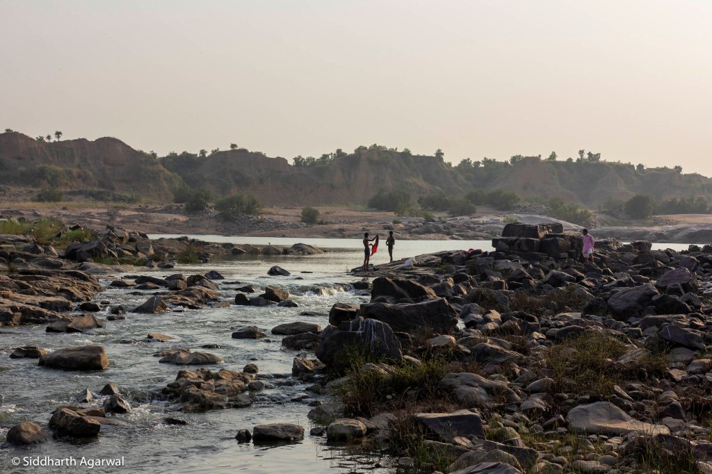
The 70 kilometers long river stretch between Singhasar village of Pawai and Rohania village in Shahnagar town thrilled us with one more stunning feature of the river. Now the place of Dabra was taken by another feature which were 10 to 15 kilometers long water channels formed in riverbed at some places which the local people were calling Dahar or Daun. The river width had fallen to about one-third. Here the natural beauty of the Ken along the Dahars and the rural life going around it looked unmatchable.
In this part, the walking trek along the river became narrower and difficult. People used to specially warn us about the depth of Dahar and the danger of drowning in it. The villagers of Ghairi and Surro downstream Pawai (Tendughat) dam, even informed us that the sighting of crocodiles along Dahar stretch was quite normal. As the Ken River here was passing through forest covered hills, we found it most alive and beautiful section of the river.
At that time the construction work of Powai dam was in the final stages. The people of Pipariya village just upstream of the dam, looked helpless in the face of administration ignoring their concerns and demands of rehabilitation, compensation. Hundreds of trees marked with red cross seemed sharing same plight and the tree felling was in progress. Today, the dam is completed, submerging villages and Dahar system upstream and affecting the villagers and aquatic eco-system downstream.
About three kilometers upstream of Powai Dam, the Ken again took the form of a Dahar. As per locals, it was meeting place of seven streams, hence it was named as Satdhara.
Ken hardly looked like a river upstream of Ramgarh fort in Shahnagar town. The width continued to decrease. Water existed at very few spots that too at stop dams or at natural depression. We were surprised to see a completely dry riverbed from Saida-Hardwar till the origin point. The situation was so dire that river had no water left even to perform last rites.

Unexpectedly, at few spots small water pools were seen in river bed which were filled with groundwater by the local villagers to feed their cattle. Sadly, the riverbed resembled an unpaved village path and instead of riverbank, we were walking through the parched riverbed of Ken.
Finally, on April 18, 2018, we reached the origin of the Ken in Rithi block of Katni district, Madhya Pradesh. In the name of river, we could see marks of dry water course made along slopy rocky terrain.
We were told by the locals that a broken bund of a farmland in Mamar village was the origin place of Kyan. The hills of Ahirgawan were visible in the backdrop dividing the watershed of Narmada and Ken. Few meters behind the origin place, a big pond was lying in dry state.
There was an old temple dedicated to Goddess Kyan, about fifty meters downstream the source point. Some locals from Rithi used to organize a low-profile ritual to mark Kyan Jayanti (birthday) on the ninth day of Kartik Purnima (after Diwali) in October-November.
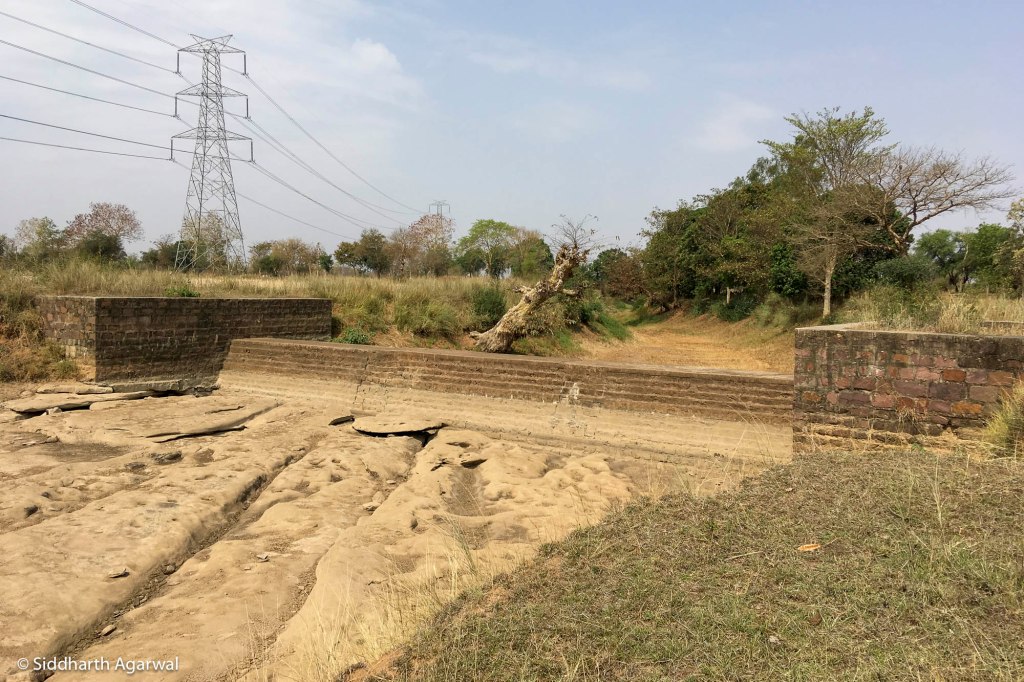
We observed that most of the water streams emerging from the catchment area were tamed behind stop dams there. Barely 200 meters downstream of the source, a stop dam on the Ken was lying in a broken condition. Half a kilometer further, the debris of then under-construction second railway line had deformed the river course beyond recognition.
This is how our Ken walk came to an end. It was only possible by walking along the river that we could understand and experience various forms and ground situations of the Ken and human life around it. We could not cover the length of the Ken river flowing through Panna Tiger Reserve as it was out of bound. We also could not walk along the river in monsoon or walk along its tributaries.
Summary
Reviewing the walk, we could comprehend that Kyan is now not a perennial river everywhere, though it may have been at many places in the past. Some stretches of the tributaries may still be perennial, but we could not walk along them. Nevertheless, there are several places in middle and lower reaches of river which are full of life and water courtesy the geomorphological phenomena of Dahar, Dabra, Dabri and the groundwater hydrology of Jhira, Jhina besides some inflows by a few tributaries. For longer part, the river runs flowless and waterless. The Dabra, Dabri and Dahar have more standing and less flowing water.
We observed that nearly half a dozen river-based lift irrigation schemes downstream of Bariyarpur barrage were unable to help farmers for several reasons including excessive sand mining and diversion of water by the barrage. Similarly, about one and half dozen stop (check) dams upstream Tighara bridge in Pawai were also failing to meet purposes they were built for. Barring a few, most of the stop dams were seen in waterless or in broken condition.
An important lesson learned from the walk is that while manmade water extracting schemes of tube wells, stop dams, lift irrigation, dam projects are struggling to deliver intended objectives apart from impacting the river eco-system adversely; the natural dams (Dahar), water pools (Dabra, Dabri) and groundwater hydrology in the form of springs (Jhira, Jhina) are keeping the river alive. But for past many years, the existence of the natural heritage is under constant threats on account of built and proposed dams, water extracting schemes, increasing sand mining, etc.

Without any independent, peer reviewed, public scientific analysis the Ken River is labeled as ‘water surplus’. On the basis of this assumption, the much-hyped Ken-Betwa River linking project is being pushed forward. Ironically, while the Ken is struggling to flow, the project plans to transfer this so called ‘surplus water’ to upper Betwa basin by creating a dam at Dodhan in Panna in sheer violation of environmental rules. There is urgent need to study and conserve the Dabra, Dabri, Dahar, Jhira, Jhina systems and its tributaries to keep the Ken River and those dependent on it alive. They are all under threat due to the proposed Ken Betwa River Linking Project.
Bhim Singh Rawat (bhim.sandrp@gmail.com)
Siddharth Agarwal (asid@veditum.org)
