After reviewing status of India rivers, SANDRP presents an account of research, studies and important reports on erratic monsoon, climate change, floods which all are severely affecting the rivers, their aquatic life and livelihood of dependent communities.
Rivers and Monsoon
Number of rainy days falling across river basins in India The study has found that number of rainy days is falling across river basins in India and rainfall intensities are seen to be increasing. The analysis determined changes in heavy precipitation and peak flood for seven river basins in India—Krishna, Godavari, Mahanadi, Narmada, Cauvery, Sabarmati and Brahamani and Baitarani. For the study, data pertaining to daily flows for about 30 odd years and precipitation for 61 years (from 1951 to 2012) were analysed.
The analysis also said the rivers which flow from west to east direction (in India) have more rainy days compared to those which flow towards the west. The study also held that anthropogenic activities (construction of storage reservoirs, diversions, urbanization, land-use change, and soil and water conservation measures, among others) have probably affected the generation of peak floods in the rivers of India. http://www.livemint.com/Politics/c7v8oXmsMDHIldjDv9k6lK/Number-of-rainy-days-falling-across-river-basins-in-India-s.html (Live Mint, 27 April 2017)
Negative rainfall in 8 out of 14 normal monsoons in 18 years Data from the IMD revealed majority of monsoons over the past 18 years had been below average like 2017, which ended on a below average note at -5%. From 2000, the country has seen as many as 12 monsoons with less rain than the long period average, more so from 2014 to 2017— a period marked by consecutive monsoons ending on a negative note.
Experts stressed there was a possibility of monsoon weakening due to the impact of the climate change, but this was something that researchers were unclear about. A K Srivastava, the head of IMD’s climate monitoring and analysis group, Pune, said, “The current epoch — from 1991 to 2020 — has shown a trend of negative or low rainfall. Past statistics show the epochal behaviour of monsoon, but how long will this rainfall trend continues beyond the year 2020 cannot be gauged.” https://timesofindia.indiatimes.com/city/pune/negative-rainfall-in-8-out-of-14-normal-monsoons-in-18-years/articleshow/60916411.cms (The Times of India, 2 Oct. 2017)
Extreme rainfall events over central India tripled since 1950 As per this study the Northern and Northwest Arabian sea is warming up so much that it contributes 36% of moisture in the monsoon, compared to just 26% by Bay of Bengal (29% by land). This has led to three-fold rise in incidents of extreme high rainfall, flash floods and landslides.
The fact that this intensification is against the background of a declining monsoon rainfall, which has been observed in previous studies, makes it even more impactful, as it puts several millions of lives, property and agriculture at risk. According to the paper, floods alone led to losses amounting to $3 billion in India, 10 per cent of global economic losses. http://indianexpress.com/article/technology/science/extreme-rainfall-events-over-central-india-tripled-since-1950-study-4875917/ (The Indian Express, 5 Oct. 2017)
Unlike what was believed earlier — that depressions formed in the Bay of Bengal are responsible for most events of heavy rainfall between June and Sept over India — this study has painted a different picture. According to the study, 13 more extreme rainfall incidents are noticed with the passing of each decade, thus making floods an annual affair for the people in Gujarat, Maharashtra, Jharkhand, Chhattisgarh, Madhya Pradesh, Bihar, West Bengal and Assam http://indianexpress.com/article/india/rapid-warming-of-arabian-sea-among-causes-of-3-fold-rise-in-erratic-rain-in-central-india-weather-experts-4873351/ (The India Express, 4 Oct. 2017)
Uneven monsoon; Flooded district face deficient rainfall Mridula Chari analyses Monsoon rainfall of 2017. As per the report, of the 630 districts for which the India Meteorological Department tracks rainfall data, 308 received between 19% more and 19% less than normal rain. But 219 received deficient rain, or 20% less than normal rain. Of those, 12 had scanty rain, or 60% less than normal rain. On the other end, 103 districts received excess rain, or 20% more than normal rain. Of those, 27 were 60% above normal. https://scroll.in/article/852793/after-uneven-monsoon-in-india-some-districts-that-faced-floods-end-with-deficient-rain
Expect more instances of fewer but intense rainy days in future: IMDIn a news report, IMD chief K J Ramesh, has said that the number of rainy days are going to shrink but the intensity of rainfall will increase. http://www.business-standard.com/article/current-affairs/expect-fewer-but-intense-rainy-days-in-coming-days-says-imd-chief-117100501147_1.html (Business Standard 5 Oct. 2017)
As per IMD, in 2017, there were several instances of very heavy rainfall over small areas with relatively prolonged dry periods in between. As a result, there was severe flooding over Assam in the Northeast, Bihar and West Bengal in the East, and Gujarat and Rajasthan in the West during July and August.
– “The rainfall was largely localised rather than being distributed over a region. Heavy rains occurred in a short period of time, within two to four days, which was followed by a prolonged dry spell over the same region,” said D SivanandaPai, head, climate research division at IMD. “This is a typical break-monsoon type, attributed to be one of the features associated with climate change.” http://indianexpress.com/article/india/central-india-stares-at-rainfall-deficit-scientists-point-to-climate-change-up-mp-bihar-4842529/ (The Indian Express, 14 Sept. 2018)
Climate change to cause more rain, but less water in rivers An extensive analysis in the Nature Scientific Reports, is based on data from nearly 50,000 rain and river monitoring sites across 160 countries. It concludes:
- More rain did not translate to more water in river systems.
- Soaring temperatures are whipping up ever-more intense storms inundating cities with flash floods but leaving the countryside and crucial agricultural land parched
- So when the big rainfall events… do fall (in rural areas), a bigger proportion of them are stored up in the soil, so you have a lesser proportion coming out as flows
- city infrastructure is struggling to cope with the harsher downpours, with flood damage worldwide costing more US$50 billion in 2013 — a figure expected to double in the next 20 years.
- Whereas extreme “once in a lifetime” floods are causing increasingly large water flows, regular cyclical inundations are having less and less of an effect on the water table. http://economictimes.indiatimes.com/news/environment/global-warming/climate-change-means-more-rain-but-less-water-in-rural-rivers-study/articleshow/60073208.cms (Aug 11, 2017)
Indian Monsoon has intensified since 2002 An MIT study in Nature Climate Change finds that the Indian monsoons during June-Sept, have strengthened in the last 15 years over north central India.
This heightened monsoon activity has reversed a 50-year drying period during which the monsoon season brought relatively little rain to northern and central India. Since 2002, the researchers have found, this drying trend has given way to a much wetter pattern, with stronger monsoons supplying much-needed rain, along with powerful, damaging floods, to the populous north central region of India. http://news.mit.edu/2017/indian-monsoons-strengthened-past-15-years-0724 (MIT News, 15 July 2017)
Severe climate change effect on Asia; India at high risk of flooding This study has revealed that climate change would bring devastating consequences to countries in the Pacific and Asia. It also warned that Southern India may witness a decline in rice yields by 5 percent in 2030s. It’s interesting to see that this report does mention SUBSIDENCE even if in passing, but no details as to the cause. 4 India Cities are listed (Mumbai, Kolkata, Chennai and Surat) facing the largest increase in annual losses. http://www.ndtv.com/india-news/severe-climate-change-effect-on-asia-india-at-high-risk-of-flooding-study-1725022 (NDTV, 24 July 2017)
India struggles to predict the weather over its lands EXCELLENT, detailed report on IMD forecasts about monsoon.
- The meteorological department officials have said that, over time, they have been able to achieve 60% certainty in forecasts for up to five days. The confidence drops after that.
- The officials also say that at the end of the season, the monsoon is still likely to be normal. “But that information isn’t really of much use because a lot of central India and parts of Maharashtra and southern India had very long dry periods,” said an IMD official on condition of anonymity. “What the department needs to do is to divide India into different zones and issue long-range forecasts for each zone.”
- What we need more is forecasts at the block level. “Knowing how much and when it will rain in Maharashtra or even in Marathwada [a cluster of eight districts in Maharashtra] doesn’t help us because rainfall varies so much even within the district,” Pande said. https://thewire.in/180850/imd-weather-prediction-forecast-monsoons-drought-agrometeorology-kharif/ (The Wire, 24 Sept. 2017)

Most river basins in India not climate resilient The new study by Indian researchers has shown that only 6 out of 22 river basins in the country have the potential to cope with the threat of climate change, particularly droughts. It is not clear what is the basis for the conclusions.:
– “We evaluated the ecosystem resilience in terms of the capability of an ecosystem to maintain its productivity during hydro-climatic disturbances,” lead researcher Dr Manish Goyal said while speaking to India Science Wire. The research team also included Ashutosh Sharma.
– “Only six river basins—Brahmaputra, Indus, Pennar, west flowing rivers of Kutch and Saurashtra including Luni basin, east flowing rivers between Krishna and Pennar basins and east flowing rivers between Pennar and Cauvery basin—were able to sustain their primary productivity by increasing the water use efficiency under driest years.”
– Ganga basin, the most populous and agriculturally important basin, was also found slightly non-resilient.
– It is clear that forests have higher resilience to withstand the climatic disturbances. The deforestation activities, in the name of economic development and expansion of agriculture, will result in making country more vulnerable to climate change. https://www.thehindubusinessline.com/news/science/most-river-basins-in-india-not-climate-resilient-study/article9876166.ece (Business Standard, 27 Sept. 2017)
Where does monsoon get over 200 lakh crore buckets of water from?Some interesting findings: “Pathak and Roxy Mathew Koll of Indian Institute of Tropical Meteorology (IITM) have prepared a map (see below) that shows the warm Indian Ocean temperatures in colors and thin contours and blue thick contours that delineate major moisture sources for the monsoon. The main moisture sources are – the Western Indian Ocean (WIO), Central Indian Ocean (CIO), Upper Indian Ocean (UIO), and the Ganga basin… Pathak’s work provides a set of baseline that can be used to diagnose the models in greater detail with a focus on moisture source rendition.”

– Most of the moisture during the initial phase of the monsoon is supplied from the WIO and CIO and this creates a north-south see-saw in rain between the ocean and land. As the season progresses into July-August, the Ganga basin begins to be a significant source and generates an east-west see-saw in rainfall between the Ganga basin and northeast India. Monsoon withdrawal is, in fact, delayed by the moisture recycling over the Ganga basin. The oceanic sources are dominant in the 30-60 day active/break cycles which tend to propagate north-westward from the Indian Ocean into the subcontinent. These sources are weaker during El Niño years. The Ganga basin is dominant in the 10-20 day lifecycle of active/break events and is a critical moisture source for the monsoon during dry monsoon years. http://www.downtoearth.org.in/news/where-does-monsoon-get-over-200-lakh-crore-buckets-of-water-from-59349(Down To Earth, 18 Dec. 2017)
2/3 of India’s terrestrial ecosystems vulnerable to drought Nearly two-third of the India’s terrestrial ecosystems is not resilient to drought, revealed this study. It also said that inability of ecosystems to tolerate water-limited conditions may pose a serious challenge in terms of carbon sequestration, crop production, and food security. It facilitates understanding of how ecosystems in different regions of India respond to hydroclimatic disturbances like droughts. Droughts are anticipated to become more frequent and intense under climate change. http://www.livemint.com/Politics/mG6mzUyYV31A8HPFLQmMmL/Twothirds-of-Indias-terrestrial-ecosystems-vulnerable-to-d.html (Live Mint, 27 Sept. 2017)

Rivers and Floods
Forests can help reduce floods As per this study by experts at IIT-Kharagpur, states with high forest cover are more likely to better cope with the flood damages. The study published in the journal Land Use Policy in July, researchers from the institute examined the impact of forest cover on flood damage in terms of human lives lost and population affected from 1998 to 2011 across all Indian states except Telangana, which came into existence only in 2014.
The study findings indicate that for a majority of states, the presence of forest cover tends to protect human lives and reduce the adverse consequences of floods significantly. For Madhya Pradesh, despite increasing forest cover, flood damage has increased. This could be due to the area claimed under forest cover being plantations and also huge deforestation that has been going on. Bihar registers the highest average number of lives lost and people affected (246.07 and 777,7357.14, respectively). It has an average forest cover of 74.26 sq. km (0.08 per cent of its geographical area),http://www.business-standard.com/article/news-ians/indian-states-with-high-forest-cover-likely-to-better-cope-with-flood-damage-experts-117082400356_1.html (Business Standard, 24 Aug. 2017)
Maharashtra Flood risk assessment of Panchganga RiverFor the present study, the middle part of Panchgangariver of Kolhapur district, Maharashtra was selected. According to Analytical Hierarchy Process analysis, high flood risk area includes nearly 17 villages in the river basin. About 42 sq. km of agricultural land, is flood vulnerable area. Also, some major roads in the study area come under the high flood risk zone. It immediately requires proper attention to avoid socio-economic losses. http://www.currentscience.ac.in/Volumes/112/04/0785.pdf (Current Science, 25 Feb. 2017)
Coastal Areas Underestimation of flooding risks in coastal cities Although this research is about three US Coastal cities yet this is equally valid for coastal Indian cities like Mumbai, Chennai, Kolkata and other cities like Surat also facing coastal influences. It shows there are three compounding impacts: High Rainfall in the city, the river flooding and impact of high tide and rarely all three are properly accounted for. There is a fourth factor that needs to be accounted for: possible impact of releases from upstream dam or breach of embankment or disaster at other water bodies. And now add to it climate change. https://www.washingtonpost.com/news/energy-environment/wp/2017/08/29/hurricane-harvey-shows-how-we-underestimate-flooding-risks-in-coastal-cities-scientists-say/ (The Washington Post, 29 Aug. 2017)

Tamil Nadu Flood in polluted river cause groundwater pollutionA new study by Anna University has pointed out that flooding in polluted rivers has the potential to make groundwater unsafe for human use.Researchers from the university collected water samples from 17 locations in Dec 2015 and April 2016 along polluted Adyar river. The results showed that the heavy-metal concentration and microbial load in groundwater samples were high. https://thewire.in/193899/polluted-river-floods-groundwater-becomes-polluted/ (The Wire, 3 Nov. 2017)
Bihar Flood disasters increasing due to climate changeThis is rare, deputy CM makes categorical link between floods and climate change. As per him, states like Bihar are the worst victims of climate change as it frequently faces floods and drought. Bihar faced major floods in 2007, 2008, 2011, 2013, 2016 and 2017 causing loss of life and property, damage to crops, roads and other infrastructure. In2017 flood, 514 people died and the state govt paid Rs 1788 crore as ex-gratia to 30 lakh affected families. http://indianexpress.com/article/india/disasters-increasing-in-bihar-due-to-climate-change-deputy-cm-sushil-modi-4862451/ (The Indian Express, 26 Sept. 2017)
NASA tool predicts Mangalore, Mumbai at flood risk Mangalore in Karnataka is at a higher risk of flooding from rising sea levels because of melting glaciers than coastal cities such as Mumbai and New York, data released by NASA shows.Over the next 100 years, glacial melt could push up Mangalore sea levels by 15.98cm compared to 15.26cm for Mumbai and 10.65cm for New York, says the study carried in the journal Science Advances. Mumbai and New York are traditionally believed to be the most vulnerable.The findings are based on a forecasting tool, Gradient Fingerprint Mapping, developed by the scientists at the US space agency’s Jet Propulsion Laboratory.It allows planners to see exactly how melting glaciers can push up sea levels for 293 major port cities, including three from India – Mangalore, Mumbai and Kakinada (Andhra Pradesh). http://www.hindustantimes.com/science/nasa-s-new-tool-predicts-which-city-will-flood-first-from-global-warming/story-mLiq4IBqZgIC3tCZ65vBhL.html(Hindustan Times, 22 Nov. 2017)
Rise in flood affected area in 36 year India’s flood-prone area has increased from 40 million ha in 1980s to 50 million ha by 2016. The report also says that India’s total geographical area is 329 million ha and in a year, on an average, 75 lakh ha are affected, 1,600 lives are lost and the damage caused to crops, houses and public utilities is Rs.1,805 crore. http://www.thehindu.com/todays-paper/tp-in-school/understanding-floods/article20607594.ece (The Hindu, 21 Nov. 2017)
CAG: Failure of CWC in flood management As per the report 14 percent of India’s landmass is vulnerable to flooding and more than 15 percent of this area gets flooded every year. Since 1953, almost 1,600 lives have been lost every year on an average due to floods. Yet, the central govt has not released 61 percent of the funds promised for flood management between April 2007 and March 2016, and 43 percent of the 517 projects approved have not been completed, a recent report by the CAG revealed. Indeed, India’s flood management has failed due to the failure of institutions like CWC, CAG and media needs to focus on that. https://www.thequint.com/news/india/flood-related-deaths-in-india (The Quint, 3 Oct. 2017)
Rivers Biodiversity Fish
Indian rivers need interdisciplinary studies for e-flow assessment This is very informative article by K D Joshi making very interesting reading, since the he was till recently also member of MoEF, Expert Appraisal Committee (EAC) on River Valley Projects. He was till recently also senior scientist at CIFRI, Govt of India’s premier institute supposed to be protecting the riverine fisheries, but lately seems more involved in consultancy studies for hydropower companies. CIFRI, unfortunately is not known for having done any effective attempt to protect riverine fisheries, which is its basic mandate. EAC also appraises environment flows and approves projects without ANY credible studies on environment flows.
The article also makes some unfounded claims. As per the author: “Till date, there is no scientific documentation of in situ water requirements of any of the fish species in relation to their spawning, nursery caring, feeding, migration (if any) and other life stages in any of the river systems.” Why is this the situation? What is CIFRI doing about it? Why is the science of estimating these factors even for the key stone fish species you mention is so poor? You mention need for multidisciplinary work. Yes, that is required, but what about taking the first step in coming up with basic criteria for each of the key stone species by CIFRI? Why is that also not done? Why is the CIFRI representative in EAC not demanding such studies, in stead of rubber stamping the EAC decisions?
SANDRP wishes there were some satisfactory responses to these questions. Today there is no place for fish or those that depend on fish or the river in the decision making process and institutes like CIFRI and their scientists are busy doing consultancies for hydropower companies. This needs to change and Dr Joshi is in an eminent position to initiate this.http://www.currentscience.ac.in/Volumes/113/09/1652.pdf
Study on adverse impact on dam on Hilsa, fisheries Destruction of Hilsa in Narmada as Sardar Sarovar Dam did not even consider its environment impact, neither was there any compensation or rehabilitation of affected.
The CIFRI study found that in nearly a decade, hilsa catch in Narmada, which recorded 5,180 metric tonnes in 2006-07, has drastically dwindled by over 90% to mere 419 metric tonnes by 2015. The highest catch of hilsa in Gujarat was recorded 15,319 metric tonnes in 1993. Thereafter the impact of under construction and than operational SSP started happening. https://timesofindia.indiatimes.com/city/ahmedabad/king-of-fish-hilsa-in-troubled-narmada-waters/articleshow/63022456.cms (The Times of India, 22 Feb. 2018)
This tragedy arose because the Narmada dam, which should be maintaining a minimum “environmental flow” of 2,200 cusecs, but instead reduced this flow to just 600 cusecs since 2005-06, according to senior officials in the Gujarat fisheries department.
The damage was done over a decade as the hilsa would not breed in waters with high salinity values. This is clearly visible in 2000-01 fisheries department data where Hilsa constituted 46% of the total 7,865 metric tonnes inland fish water catch, while six years later, soon after the environmental flow was reduced to 600 cusecs, the Hilsa catch plummeted to 21% of the total 21,902 metric tonne catch. “Sadly, it is only now that the Gujarat government has requested the Narmada Control Authority (NCA) to be allowed to increase its environmental flow to 1,600 cusecs,” added the senior fisheries official. https://timesofindia.indiatimes.com/city/ahmedabad/narmada-hilsa-dying-out-as-dam-flow-diminishes/articleshow/63020600.cms (The Times of India, 22 Feb. 2018)
Study For hilsa conservation protect the livelihood of hilsa fishermen Findings of International Water Association study:Hilsa catch has been declining over the last 30 years in West Bengal and Bangladesh due to overfishing, siltation of river beds, reduced water flow and fragmentation of rivers during dry months.
-A few years ago, the Bangladesh govt took up a slew of measures, including the banning of hilsa fishing during the spawning and breeding seasons.Though the W Bengal fisheries department also subsequently amended their respective inland and marine fisheries laws to implement a ban on hilsa fishing during the spawning and breeding season, the implementation was patchy and hence produced little results.
-One of the major problems of the present day conservation management is that it doesn’t take into consideration the livelihood of traditional hilsafisherfolk. The study recommends that the livelihood of fishermen and conservation must go hand-in-hand if it has to work. In other words, hilsa conservation needs to go beyond the immediate ecological context. http://www.thehindubusinessline.com/news/national/copyofbl04ndtvjhilsabl/article9944157.ece (Business Line, 5 Nov. 2017)
Damming rivers water impacts fish diversity This new study has found that dams and other barriers across rivers in the Western Ghats do affect fish species and their recovery downstream. However, barrier-free tributaries that drain in to these rivers can help fish recover even in dammed stretches; protecting such tributaries could be crucial to maintaining fish diversity in the Western Ghats.
The Western Ghats is home to 290 freshwater fish species, more than half of which are endemic. While other studies have shown that river barriers such as barrages and dams can affect fish diversity, there is no hard evidence to prove this in the Western Ghats. To test if barriers across a 72-km stretch of Karnataka’s Malaprabha River in the central Western Ghats could affect fish diversity, scientists from the Asoka Trust for Research in Ecology and the Environment (ATREE) compared fish diversity both upstream and downstream of barriers. http://www.thehindu.com/sci-tech/science/damming-river-water-impacts-fish-diversity/article19140868.ece (The Hindu, 24 June 2017)
Study As climate changes, our fish are at sea There is growing, substantial evidence that climate change has affected fish and other marine population over the decades. A national study on the vulnerability of Indian fish stock due to climate change showed that fishes on the east coast were more vulnerable (72%) than those on the west coast (30-33%). https://timesofindia.indiatimes.com/city/kochi/as-climate-changes-our-fish-are-at-sea/articleshow/62689399.cms (The Times of India, 29 January 2018)
Rivers Biodiversity: Dolphins
Indus Dolphins; very few but very threatened British explorers discovered the South Asian river dolphins that inhabited the rivers of India, Bangladesh, Nepal and Pakistan in the early 19thcentury. However, the dolphins’ movements were affected when the British began building barrages and dams. The Indus was no exception; work on the barrages commenced in the early 1900s. With India’s independence and the ensuing partition, Pakistan became home to the fragmented river stretches where the Indus river dolphins dwelled. Research shows that as of 2011, around 1,450 individuals remain in Pakistan in five fragmented populations split between six barrages on the Indus, while dolphins in the tributaries of Jhleum, Chenab, Ravi and Sutlej have been completely wiped out. http://www.sanctuaryasia.com/magazines/conservation/10570-indias-indus-dolphins-very-few-very-threatened.html (Sanctuary Asia, 2017)
Ganga Climate Change threatens dolphin habitat This article about Dolphins in Ganga in Bihar provides some interesting insights like the deep water habitat, how they move their habitat in monsoon to the flood plains, and how they travel to feed, etc. It says that between 2014-15 and Nov 2017, number of Dolphins has reduced by 25% in the Munger-Farakka 250 km stretch. Bihar govt is to undertake a survey of Dolphins in Ganga in 2018, after a 2012 survey along the 525 km long Ganga in Bihar from Chausa (Buxar) to Manihari (Katihar), and had in 2012 found 1500 dolphins. Strangely the article does not mention how DREDGING of the river for WATERWAYS is also destroying the Dolphins habitat as other experts have pointed out. http://indiaclimatedialogue.net/2018/01/22/climate-change-threatens-dolphin-habitats-ganga/ (India Climate Dialogue, 22 Jan 2018)

Bihar Dolphins in river Ganga are suffering Gillnet emerges biggest killer ofGangetic dolphins followed by poaching. http://indiatoday.intoday.in/story/gangetic-dolphins-condition-india-river-ganga-bihar-gillnet-fishing-lifest/1/1119887.html(India Today, 29 Dec 2017)
Pesticides in Ganga flood plain threatening aquatic life According to report, several hectares of silt banks are illegally grabbed by land sharks every year and leased out to landless farmers at Rs 2,000 – Rs 5,000 per bigha. Farmers from villages in Bijnor, Muzaffarnagar, Saharanpur and Meerut are seen utilizing these silt banks for seasonal farming between December to February. Chemical farming on Ganga banks is indeed causing damage to river ecosystem but labeling floodplain farmers as land mafia would not help it. Good to see, district administration planning to promote organic farming among these farmers. https://timesofindia.indiatimes.com/city/meerut/pesticides-in-silt-banks-of-ganga-threatening-aquatic-life/articleshow/62595668.cms (The Times of India, 21 Jan. 2018)
Rivers Biodiversity Ghariyal
Study finds breeding gharials in Parvati river A study has discovered the presence of breeding gharials in the Parvati river, a tributary of the Chambal flowing on Rajasthan-Madhya Pradesh border. The report states that the National Chambal Sanctuary (NCS) holds the largest gharial population, estimated at above 80% of the species in the world. Smaller numbers of the species thrive in Katerniaghat Wildlife Sanctuary on the Girwa river, in Chitwan National Park (Nepal) on the Narayani river, on the Gandak river in India, and in Corbett National Park on the Ramganga river. https://www.hindustantimes.com/jaipur/study-finds-breeding-gharials-in-parvati-river/story-vZ3bmT2gZqGS4hys2mhn5J.html (Hindustan Times, 28 Jan. 2018)

Impacts of National Waterways
Study Boosting river transport on Ganga and Brahmaputra has costs A new study from CUTS International – “Expanding Tradable Benefits of Trans-boundary Water: Promoting Navigational Usage of Inland Waterways in Ganga and Brahmaputra Basins”, identifies some of the challenges for policymakers trying to realise these opportunities, and for communities living along the riverbanks. “Cumulative impact of these is also a recipe for disaster to the local communities living around the rivers, specifically the fishermen and agrarian communities that depend on the riverbeds for their overall sustenance,” warns the report. https://www.thethirdpole.net/2018/02/19/boosting-river-transport-on-ganga-and-brahmaputra-has-costs/ (The Third Pole, 19 Feb. 2018)
Centre IWAI to study impact of waterways on dolphins The Inland Waterways Authority of India (IWAI) has decided to conduct an impact study on the Bihar-Jharkhand Gangetic stretch. The National Waterways (NW)-1 project covers two significant aquatic wildlife sanctuaries—Kashi Turtle Sanctuary in Varanasi and Vikramshila Dolphin Sanctuary in Bhagalpur. Though the IWAI has got permission from the UP wildlife board for ship navigation through the Kashi Turtle Sanctuary, the Bihar wildlife board is yet to allow the same through the Vikramshila Dolphin Sanctuary. Wildlife researchers have said that navigation of heavy ships on the Ganga would be a potential threat to the survival of dolphins in the sanctuary as well as on the entire Bihar and Jharkhand stretch. Let us see how credible this study is. The impact has already started with the dredging going on for several months, as SANDRP blog reported many months ago. https://www.hindustantimes.com/ranchi/iwai-to-study-impact-of-waterways-on-dolphins/story-whwSqisKXow7aGwW8W87aN.html (Hindustan Times, 15 May 2017)
Report Impacts of national waterways on rivers, ecology and livelihoods In this comprehensive report Shripad Dharmadhikary writes that the govt has made a strong push for inland waterways but confusion over environmental assessments and clearance processes cloud development. https://www.thethirdpole.net/2017/11/09/indias-national-waterways-impacts-on-rivers-ecology-and-livelihoods-must-be-addressed/ (The Third Pole, 9 Nov. 2017)
Jhelum Increased siltation raises flood threat Kashmir’s deforested hills have been the prime cause of the heavy siltation of its water bodies. This is now being aggravated by changes in land use due to water scarcity in the catchments of the Jhelum – caused partially by climate change – adding to the siltation load in the river that feeds the Wular Lake, Kashmir’s largest flood basin. https://www.thethirdpole.net/2017/09/18/increased-siltation-raises-kashmir-flood-threat/ (The Third Pole, 18 Sept. 2017)
Bihar Rs 42.93 lakh for study on siltation in Ganga Bihar State cabinet on Sept 19, 2017 has sanctioned Rs42.93 lakh for a detailed study on siltation in the Ganga between Farakka in West Bengal and Buxar in Bihar over a period of six months. The study would also focus on the impact of operation of Farakka barrage. Drones would also be used to assess the silt load at various points in the river.Dr Rajiv Sinha, professor at the department of earth sciences at IIT Kanpur, has been hired as consultant for the study. http://timesofindia.indiatimes.com/city/patna/rs-42-93-lakh-for-study-on-siltation-in-ganga/articleshow/60756127.cms (The Times of India, 20 Sept. 2017)
Studies, Reports On Himalayan Glaciers
Small Himalayan glaciers more sensitive to climate change This study fills an important gap. Researchers have now used a new technique to estimate the mass of glaciers and a new model to estimate the volume loss over a long period.
– The study, which covered 146 glaciers in the Chandra basin in the western Himalayas, shows that these glaciers as a whole have lost 19 percent of the total basin volume during the period from 1984 to 2012. However, the loss of volume for small and low-altitude glaciers in the basin is as high as 67 percent in the same period.
– The total surface area of the selected glaciers is about 660 square kilometres. The total ice volume estimated for these glaciers is 62 gigatonnes (with error margin of ± 16 gigatonnes). In total, the Chandra basin has experienced a water loss of 11.1 gigatonnes (with a margin of ± 8 gigatonnes) from 1984 to 2012, which is about one-fifth of the total estimated volume.
– “This is the first time, not only in India but globally, that we have an estimate of how much volume and mass of glaciers have been lost over a period of time in a large basin. This is the first reliable estimate of both how much water is stored and how much has been lost in the past 30 years,” Anil V. Kulkarni, the professor at the Divecha Centre for Climate Change, Indian Institute of Science, Bangalore, who led the research team said. http://www.indiawaterportal.org/articles/small-himalayan-glaciers-more-sensitive-climate-change (India Water Portal, 4 Sept. 2017)
Faster, Bigger Avalanches, Triggered by Climate Change Little known impact of climate change that can bring disasters also for Indian Himalayas.
– There are two kinds of mountain glaciers: flat and steep. When a flat glacier collapses, it can move a lot of snow and ice, but in slow motion. These “surges” can last weeks and even years, but move no more than a few hundred feet a day.
– Steep glaciers appear perilously affixed to mountain walls, and when they do collapse they create avalanches with speeds up to 250 m.p.h. Those avalanches may imperil mountain climbers, but over all they don’t move as much snow and ice.
– In Tibet, however, researchers saw a frightening hybrid of the two. “It was a flat glacier, but it produced speeds of up to 300 kilometers per hour,” or 186 m.p.h., said Andreas Kääb, a professor of geosciences at the University of Oslo in Norway and lead author of the study.
– Scientists say the driving factor in Tibet was climate change.

– Warmer air caused by climate change — the region has warmed 0.4 degrees Celsius per decade since the 1960s — holds more moisture, leading to more winter snowfall. While many glaciers around the world are in retreat because warmer temperatures are melting them, the Tibetan glaciers that collapsed are among those that are growing because of more snow.
– In the summer months, there has also been more rain. That water created crevices through the glacier and saturated the ground below, acting as a kind of lubricant. With more weight on top and less friction to hold the glacier in place on the bottom, it collapsed. https://www.nytimes.com/2018/01/23/climate/glacier-collapse-avalanche.html (The New York Times, 23 Jan 2018)
Jammu & Kashmir Glaciers melting fast, but no increase in rivers flow Researchers Romshoo and Khalid Omar Murtaza studied the health of nine “benchmark” glaciers in Kashmir Himalayas between 1980 and 2013. The data analysis showed the glaciers in Lidder valley have shrunk by 17%. The annual air temperature has shown increasing trends while a slight decrease in precipitation has also been noticed.
The total glaciated area of the nine benchmark glaciers in 1980 was 29.01 sqkm which reduced to 23.81 sqkm in 2013. However, the melting of glaciers has not raised the water level in the rivers. RenojThayyen, scientist at National Institute of Hydrology explains that it depends where you are measuring the discharge and in what climate system. If the catchment area has 100 percent glacier cover, then higher melting will lead to higher discharge. But such catchments hardly exist. As glacier cover decreases, flow regime is controlled by precipitation. Higher melting is linked to reduced snow cover which covers a wider area in high altitude catchment. So reduced snow cover and precipitation is leading to reduced discharge downstream. http://timesofindia.indiatimes.com/home/environment/global-warming/kashmir-glaciers-shrinking-rapidly-says-study/articleshow/60051698.cms(The Times of India, 14 Aug. 2017)
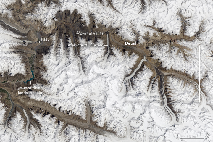
Similarly, NASA update explains a new kind of phenomena unique to this SHIMSHAL River in INDUS basin in Karakoram mountains in Northern Pakistan: “In the Karakoram Mountains of northern Pakistan, the remote Shimshal Valley has the same concern, but for a somewhat different reason. Several of the glaciers that flow into this valley surge, meaning they cycle through periods when they flow forward several times faster than usual. Since the valley is narrow and has a river running through it, surging glaciers regularly dam the river and create flood hazards. The floods occur when water pooling up behind the tongue of the advancing glacier suddenly breaks through the natural ice dam and cascades down the gorge. https://earthobservatory.nasa.gov/NaturalHazards/view.php?id=90672&src=nha (Earth Observatory, 13 May 2017)
On the other hand, there is a contrary report providing reason why Glaciers along Karakoram range are not melting. The summer cooling over the range appears to be result of a unique interaction between the Karakoram vortex and the South Asian monsoon, which results in the temperatures over Karakoram and Pamir to cool, even as the Central and Eastern Himalayas are warming, the studies have shown. It said that over recent decades, these vortex-monsoon interactions have resulted in stormier conditions over the Karakoram. http://www.thehindubusinessline.com/news/science/cool-karakoram-glaciers-defy-global-warming-trend/article9818629.ece (The Hindu Business Line, 15 Aug. 2017)
Himachal Pradesh Spiti valley runs dry as global warming hits the Himalayas Himalayas are one of the world’s most sensitive hot spots to climate change. Melting glaciers, erratic rainfall, less snow and rising temperatures are taking their toll. And Spiti Valley is clearly showing the signs.Their main form of irrigation which are “kuls” — man-made channels running from glaciers to village ponds — are dry. As a result, sheep and goat herders have to trek higher to find grazing land and crops are much harder to cultivate.
Residents also say that it has become warmer over the last few decades, there is less snowfall and the winters have become shorter and summers longer. A 2014 JNU study has cited that the annual temperatures in the Indian Himalayas rose by up to 2 degrees Celsius over two decades, while the area of glaciers here have reduced by 13% over five decades. Experts say the food, water and energy security of not just the people here — but large part of over one billion others’ across Asia who depend on rivers such as the Yangtze, Ganges and Mekong, which are fed by Himalayan glaciers — is at stake.https://www.hindustantimes.com/india-news/world-s-highest-village-runs-dry-as-warming-hits-the-himalayas/story-QSAB2bLTwWSFobNrm56uxM.html (Hindustan Times, 1 Aug. 2017)
Uttarakhand Receding Ganga Glaciers In olden time the snout of the Gangotri glacier Gaumukh was extended as far as Gangotri town, located almost 18 km away. However, uncontrolled development activities including deforestation, rampant construction and unregulated flow of tourists (and the pollution caused by their vehicles) has caused the glacier -which is around 30-km long and 0.5 to 2.5 km wide -to not just recede but also raised worries over the continuing health of the source of the country’s most revered river.
According to scientist DP Dobhal, Gangotri glacier has been under a state of continuous recession since 1935. The Geological Survey of India which monitored the glacier from 1935 till 1996 found that the glacier retreated by 1147 metres, with an average rate of 19 mtr year between 1935 and 1996. The total area vacated by the glacier during 1935 to 1996 is estimated to be 5.78 ha. https://timesofindia.indiatimes.com/india/at-its-source-ganga-runs-an-obstacle-course/articleshow/60897628.cms (The Times of India, 1 Oct. 2017)
Lake that caused Kedar floods now dry Chorabari lake breached on June 17, 2013, triggering floods in Kedarnath. Now it has no water, reports Rohit Joshi. The lake is estimated to have formed around 15 to 17,000 years ago by rain water and snow melting from the surrounding mountains. In the past few decades, scientists had found only 4-5 meters of water level in the lake. But just before the disaster, on June 13, 2013, WIHG (Wadia Institute for Himalayan Geology) scientists reported that the lake’s water had risen up to 7 m. On June 16, 315 mm of rain was recorded in the area in just 24 hours contributing to further increase in the water level of the lake. “The capacity of this lake was 20 meters, but on the day of the disaster, an avalanche occured and tons of snow had fallen into the lake. It caused the lake’s embankment to burst. A detailed report prepared by WIHG found that more than 262 million litres of water and tons of debris rained on Kedarnath town in a few minutes causing that terrible catastrophe,” said Dobhal. https://timesofindia.indiatimes.com/city/dehradun/lake-that-caused-kedar-floods-now-dry-will-take-100-yrs-to-restore/articleshow/61134966.cms (The Times of India, 18 Oct. 2017)
Sikkim Glacier retreating fast in Teesta catchment At a time when Govt of Sikkim is planning to operationaliseTeesa III hydro power project, This blog shows how Gurudongmar Glacier is retreating in the catchment of the river posing a question marks on the success of planned and built hydro projects. https://blogs.agu.org/fromaglaciersperspective/2017/05/02/gurudongmar-glacier-retreat-teetsa-river-hydropower-sikkim/ (Blog AGU, 2 May 2017)
Meghalaya State facing flash flood threats A new study has shown that air temperature in Meghalaya is rising at the rate of 0.031 degree per year. The trend is consistent from 1981 to 2014, barring two years, 1991 and 1992. The study also indicated abnormal change in rainfall pattern in the State. There will be more cloud bursts leading to related disasters like flash floods and landslides. http://www.theshillongtimes.com/2017/07/05/meghalaya-braces-for-environment-doomsday/(The Shillong Times, 5 July 2017)
River Pollution, Water Extraction
Maharashtra Untreated sewage helps mangroves Discharge of untreated sewage and other urban waste into the sea has helped in growth of mangroves, found a two-year research on Thane, Malad and Manori creeks by National Environment Engineering Research Institute (NEERI).
For the study, NEERI evaluated the changes considering satellite images of the years 1972, 1994 and 2016 using remote sensing analysis. It was observed that while there was destruction of mangroves due to construction and developmental activities, new growth of mangroves was observed in the creeks’ inner periphery. The report stated that favourable ambient conditions led to the formation of mudflats and ultimately increased the growth of mangroves. https://timesofindia.indiatimes.com/city/mumbai/study-thane-malad-manori-creeks-choke-as-untreated-sewage-helps-mangroves-flourish/articleshow/58450814.cms (The Times of India, 1 May 2017)
Godavari Sensor network to map and predict pollution A group of U.S. researchers is working on a system to map undulating pollution trends in the Godavari, one of the India’s longest river. Using a mix of methods, including satellite-monitoring, traversing stretches of the river to collect water samples and using special sensors to measure bacterial and chemical pollution, the researchers are trying to develop a cost-effective forecast system. http://www.thehindu.com/news/national/the-project-started-eight-months-ago-and-has-so-far-identified-two-hotspots-of-pollution/article19259008.ece(The Hindu, 11 July 2017)
Karnataka ‘Overexploitation of water alters perennial streams’According to Report by IISc Scientists about Nethravati Basin overexploitation of water for monoculture has altered some of the perennial streams in the ghats of the Netravathi river basin to intermittent streams coming in the way of perennial nature of the Netravathi. Referring to the forest cover of 2016 in the basin, it said that the area under forests stood at 51.67 % after losing significant green patch for mini-hydroelectric, infrastructure projects and monoculture plantations. The plantations constituted 26.42 % of the basin. Large tracts of forests have been replaced with monoculture plantations such as acacia, eucalyptus, rubber, teak, coffee, cocoa, and arecnaut plantations. http://www.thehindu.com/news/cities/Mangalore/overexploitation-of-water-alters-perennial-streams/article22853035.ece (The Hindu, 26 Feb. 2018)
The report also finds that an unplanned development path adopted by “unscrupulous decision-makers” is threatening the ecologically sensitive regions in the Netravathi river basin. The report titled “Carrying capacity of Netravathi river basin based on the ecological sensitiveness” was released by Energy and Wetlands Research Group, Centre for Ecological Sciences, IISc, at Alva’s College during the pre-lake 2018 conference jointly organised by the IISc and Alva’s Education Foundation. http://www.thehindu.com/news/cities/Mangalore/unplanned-development-path-threatening-netravathi-river-basin/article22840226.ece (The Hindu, 24 Feb. 2018)
Kerala Central Travancore rivers This study predicted that degradation of virgin forests in the catchment areas, unscientific sand-mining, degradation of tributaries, pollution caused by garbage, and illegal fishing using poison, dynamite, etc. were posing major threats to these once vibrant river systems of region comprising Pathanamthitta, Kottayam and parts of Alappuzha. http://www.thehindu.com/news/national/kerala/experts-predict-death-of-6-rivers/article19941417.ece (The Hindu, 28 Oct. 2017)
Frogs heading uphill to escape climate change Giving more credence to the rising impact of climate change in the biodiversity hotspot of Wayanad, researchers have found that endangered frog species are moving up the mountains to cope with rising temperatures and drier conditions that have set in their relatively low-altitude mountain habitats. Wayanad is one of the four climate change hotspots in the state and listed as highly-vulnerable to the vagaries of weather. In recent years, Wayanad has seen an influx of various invasive species that are believed to be linked to the changing weather conditions. This is intuitively predictable but good to see evidence for this. https://timesofindia.indiatimes.com/city/kozhikode/frogs-heading-uphill-to-escape-climate-change/articleshow/5761370 (The Times of India, 13 March 2017)
Gujarat 45 villages use toxic water for irrigation A study conducted by IIPH-Gandhinagar and the Centre for Development Research of the University of Bonn, involving 652 households in villages located on the banks of the Sabarmati river, has found high levels of Escherichia coli, the bacteria that has contaminated even the drinking water of these households. The study shows the expected impact of Sabarmati River Front Development Project for villages along the river downstream from Vasna barrage, downstream of Ahmedabad. https://timesofindia.indiatimes.com/city/ahmedabad/45-villages-use-toxic-water-for-irrigation/articleshow/57832858.cms (The Times of India, 26 March2017)
Uttar Pradesh Gomati flow goes down by 40% According to Uttar Pradesh Pollution Control Board (UPPCB), Gomti’s flow has reduced by 35 to 40 per cent over the years. The river is at its filthiest in Lucknow; it has been declared one of the most polluted river stretches in the country by the CPCB.

Experts have confirmed a number of harmful heavy metals in the river, which is the lifeline of the state capital. For the first time, arsenic has also been found in the 13 km stretch passing through Lucknow, setting alarm bells ringing for the city to make concerted efforts to save the river. http://www.newindianexpress.com/thesundaystandard/2017/nov/25/going-down-the-drain-polluted-river-gomti-gasps-for-breath-1711071.html (The New Indian Express, 25 Nov. 2017)
Pollution changing countries rainfall acidic Analysis of rainwater samples from Nagpur, Mohanbari (Assam), Allahabad, Visakhapatnam and Kodaikanal in the decade 2001-2012 showed a pH level varying from 4.77 to 5.32, indicating that these places have been receiving `acid rain’. Rainwater with pH below 5.65 is considered acidic. This will have far reaching consequences. https://timesofindia.indiatimes.com/life-style/health-fitness/health-news/pollution-turning-countrys-rainfall-acidic-says-study/articleshow/57462230.cms (The Times of India, 4 May 2017)
Global 10 rivers taking 90% plastic to the oceans New research reveals that just 10 river systems transport more than 90% of plastic waste to the world’s oceans. If we continue at this rate, some estimate that our oceans will contain more plastic than fish by 2050. Two are in Africa (the Nile and the Niger) while the other eight are in Asia (the Ganges, Indus, Yellow, Yangtze, Haihe, Pearl, Mekong and Amur). https://www.theguardian.com/science/2017/nov/05/terrawatch-the-rivers-taking-plastic-to-the-oceans (The Guardian, 5 Nov. 2017)
As per another report, raising alarm over plastic fibers entering water supply mentions that the world cranks out 300 million tons of plastic each year. https://www.pri.org/stories/2017-09-05/if-youre-drinking-tap-water-youre-consuming-plastic-pollutants (PRI.Org, 5 Nov. 2017)
Other Important Studies, Reports
Center No reduction in rivers flow: CWC While reports by some experts have expressed concern about reduction in water flow in rivers, the annual average flow data maintained by Central Water Commission (CWC) for last 20 years for major/important rivers in the country does not indicate any significant reduction in water availability.
About National River Conservation Plan (NRCP) The NRCP has so far covered polluted stretches of 31 rivers (excluding Ganga and its tributaries) in 75 towns spread over 14 States at a sanctioned cost of Rs. 4517.82 crore. So far, Central share of Rs. 2197.97 crore has been released to the State Govts for implementation of various pollution abatement schemes and sewage treatment plant STP capacity of 2455.43 MLD has been created under the NRCP. This information was given by Minister of State for MoEF Dr. Mahesh Sharma in a written reply to a question in Lok Sabha. http://www.pibregional.nic.in/PressReleaseIframePage.aspx?PRID=1519160 (PIB, 2 Feb. 2018)
Sutlej Sutlej played bigger role in Indus Civilisation than thought This new geological investigation has claimed that the Harappan sites of Banawali and Kalibangan occupied a valley in which the river Sutlej used to flow before it shifted course 8,000 years ago. https://www.nature.com/articles/s41467-017-01643-9, https://thewire.in/200038/study-says-sutlej-bigger-role-play-indus-civilisation-hampers-saraswati-theory/ (The Wire, 28 Nov. 2017)

Compiled by Bhim Singh Rawat, SANDRP (bhim.sandrp@gmail.com)
You may also like to see Rivers Review 2017 for other Indian States
North India Rivers Review 2017: Pollution Poisoning Lifelines
Maharashtra Rivers Review 2017: Multi-colored Rivers!
West India Rivers Review 2017: Govts, Industries Destroy Rivers
South India Rivers Review 2017: More Water for Cities from Drying Rivers
Kerala Rivers Review 2017 : Government Efforts Fail To Protect Rivers
Tamil Nadu Rivers Review 2017: Despite Drought; Diversion of Rivers
Positive Rivers Stories 2017: Citizens Reconnecting with Rivers

Congratulations Bhim Singh ji Rawat, you have done waht for decades could not be summarised by any one, kindly keep it up — Harsh Vardhan
LikeLike
This is a very good analysis.This will help in assessing the Water availability and sustainability..Kindly project information on water table of ground water This will help you in studying Your attempt is wonderful We worked on cauvery water analysis Your approach is quite good. Congratulations May God bless you.
LikeLike
Many thanks for the kind words, sir.
LikeLike