Even as the rainfall during South West Monsoon of India during June Sept 2018 was 9.4% below normal, a number of HFL (Highest Flood Level) crossing flood events were recorded on CWC’s (Central Water Commission) Flood Forecasting (FF) website[i]. Since CWC’s FF site does not provide archived information or comprehensive list of such events, we are here putting together a list of such events that we had noted during the SW monsoon, for future records and also understanding trends of high floods. Continue reading “HFL crossing flood events during India SW Monsoon 2018”
Tag: Assam
Monsoon 2018 Overview: Serious Anomalies Hidden by Macro Figures
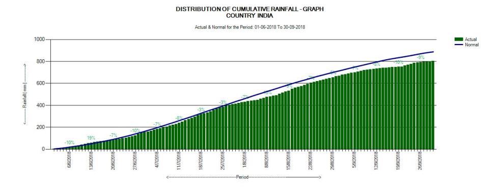
2018 becomes fifth year in a row when India’s south west monsoon has been below normal. In the beginning of monsoon season, Indian Meteorological Department (IMD) has forecasted rains to be normal with rainfall equal to 97 percent of the long term average. However at the end of the season the overall rainfall turned out to be 91 percent, with deficit of 9 percent at national level. However, as we see in this overview, the situation as move from national to local figures, is much different, mostly much worse.
According to IMD’s State Rainfall Map (cumulative) dated 30 Sept. 2018, the country received 804.0 mm rains against 887.5 mm of normal average. Thus the south west monsoon 2018 had 9.4 percent below normal rainfall.
Continue reading “Monsoon 2018 Overview: Serious Anomalies Hidden by Macro Figures”
Overview of CWC Flood Monitoring Sites 2018: INDIA
Central Water Commission is the only agency doing flood forecasting in India. As per CWC’s Flood Forecasting website[i] the Data Flow Map has information about 226 Flood Forecast Sites in the country comprising of 166 Level Forecast Sites and 60 Inflow Forecast Sites. It also monitors 700 Flood sites, information made available through List Based Exploration and Hydrograph View, but no flood forecasting is done for these sites.
In order to better understand the CWC’s flood monitoring and forecasting work, SANDRP has published report of CWC’s Level Forecast, Inflow Forecast and level monitoring sites in 5 zones of North India[ii], North East India[iii], East India[iv], South India[v] and West India[vi]. Through this report, we have presented all the data at one place with links to separate zone wise reports with detailed description.
Continue reading “Overview of CWC Flood Monitoring Sites 2018: INDIA”

Reply to CWC response on SANDRP’s article on CWC’s flood forecasting in NE India
On Aug 5, 2018, SANDRP had uploaded blog[i] titled: “Overview of CWC’s Flood Monitoring & Forecasting in North East India”. CWC posted its 3-page reply to it around 7 pm on Aug 7, 2018.
Firstly, we welcome CWC’s reply to SANDRP blog. Here some responses to the content of what CWC has replied. Continue reading “Reply to CWC response on SANDRP’s article on CWC’s flood forecasting in NE India”
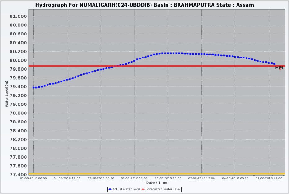
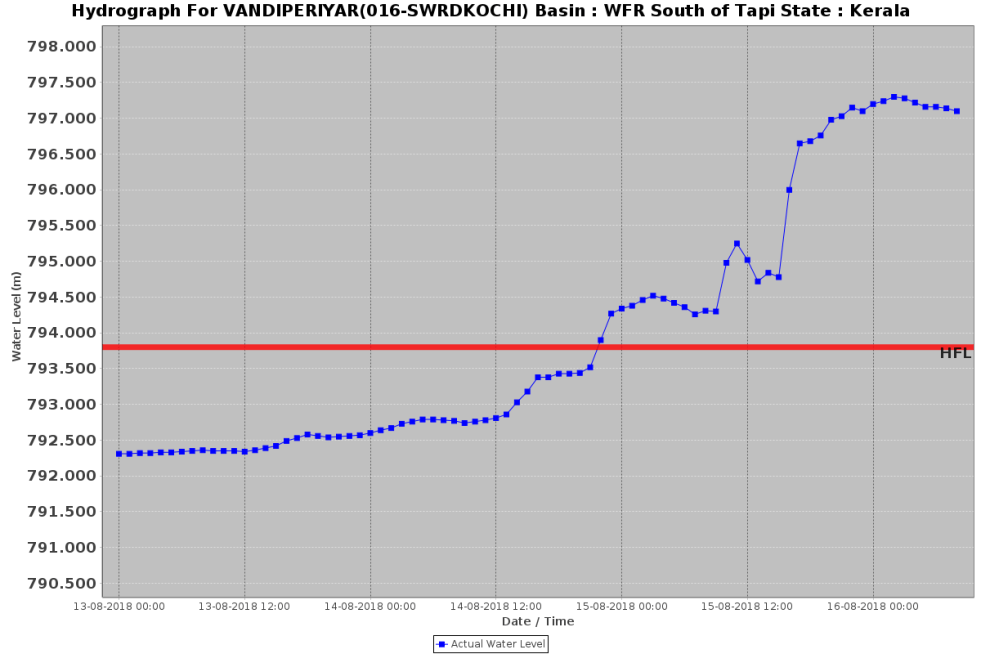
Role of Doyang Dam in bringing unprecedented floods in Golaghat
When Dhansiri river broke the highest flood level mark at Numaligarh site in early hours of Aug 2, 2018 in Golaghat district in Assam, it was not only completely out of the blue, the whole episode was unprecedented.
The earlier Highest Flood Level of Dhansiri River at Numaligarh was 79.87 m. The new HFL, it seems, was 80.18 m, full 31 cm above the previous HFL. This is rather rare, normally the new HFL would be a few cm higher, not almost one third of a meter. Secondly, the water level remained above 79.87 cm, the old HFL, for over 60 hours. This is also unusual, normally the water level rarely remains above HFL for more than a day or so. Thirdly, the earlier HFL was achieved on Sept 24, 1985, so this sudden episode of flood was breaking 33 year old record. Continue reading “Role of Doyang Dam in bringing unprecedented floods in Golaghat”
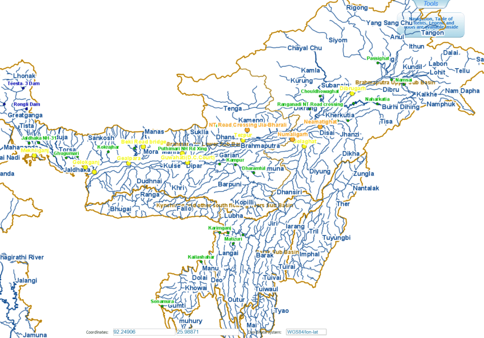
Overview of CWC’s Flood Forecasting Sites 2018: North East India
Central Water Commission (CWC) measures and monitors water level at 700 hundred Flood Forecasting site in the country. It publishes this information on its Flood Forecast website[I]. The website has three ways to get this information: Data Flow Map, List Based Exploration, and Hydrograph view. The Hydrograph view provides information for past 72 hours, supposed to be updated every hour. This is in addition to the list of current forecasts.
As per the website the Data Flow Map has information about 226 Flood Forecast Sites in the country comprising of 166 Level Forecast Sites and 60 Inflow Forecast Sites. It also monitors 700 Flood sites, information made available through List Based Exploration and Hydrograph View.
In order to better understanding the CWC’s flood monitoring and forecasting work, in this article we have given state wise list of CWC’s Level Forecast, Inflow Forecast and level monitoring sites in North East India. For better understanding, we have also included part of West Bengal that is in Brahmaputra basin here, in addition to the 8 North Eastern states. Similar report has been published for North India[II] and we hope to publish reports covering other regions of India too.
Continue reading “Overview of CWC’s Flood Forecasting Sites 2018: North East India”
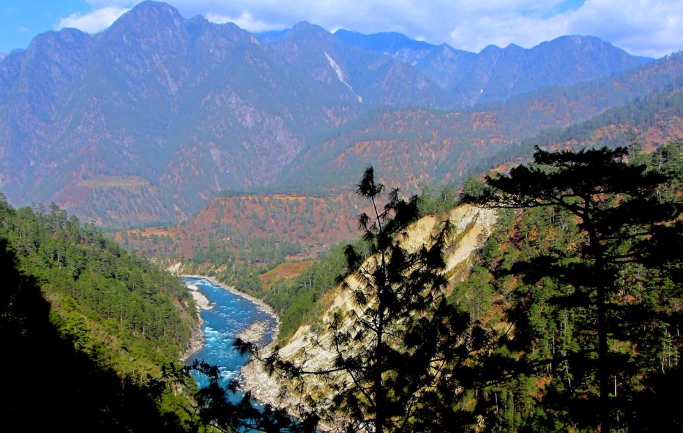
Photo Journey along free flowing Lohit River in Arunachal Pradesh
Guest Blog by Nivedita Khandekar
An abundance of a river and fast diminishing forests This photo-story chronicles the various moods of Lohit river from the point it enters India to the point where it is joined by two equally big rivers to form the mighty Brahmaputra. All photographs taken by Nivedita Khandekar during various journeys over the last decade, mostly in winters.
From references in Indian mythology to the location for proposed cascade of hydro-power projects, Lohit river of Arunachal Pradesh in north-eastern India is unique in many ways. It enters India at the juncture of Tibet, Myanmar and India at the easternmost point. It is as if this free-flowing, almost tempestuous river, cutting across the Himalayan hills, draws its tenacity from the people abounding its path. It would not be wrong to say that the unpretentious Meyor and the Mishmi communities lend their character to the river they call their own. After meandering through the Mishmi Hills, it traverses a short distance at the foothills as if freed from hilly prison only to assimilate its huge volume of waters with two other giant rivers to form the colossal Brahmaputra. Continue reading “Photo Journey along free flowing Lohit River in Arunachal Pradesh”

Floods in Tripura, Mizoram, Barak Valley in June 2018
The second wave of floods (first wave came in around May 20-24) this year inA North East India is affecting Tripura, Mizoram and mainly Barak Valley in Assam. Worryingly, while CWC flood forecast site shows water level reaching unprecedented levels in Manu river at Kailashahar in North Tripura District, CWC seems to have NO flood forecasting site in Mizoram. At Matizuri site in Hailakandi district in Barak Valley in Assam, the Katakhal river also approaching its highest ever flood level. In Bangladesh too sites like Amalshid have crossed the HFL. Continue reading “Floods in Tripura, Mizoram, Barak Valley in June 2018”
SOUTH ASIA 2017: MISS YOU, RIVERS & FISH! As Dams and Water sharing dominate
India-Bangladesh-Myanmar face big quake threat A giant fault in the earth’s crust in one of the world’s most densely populated areas could kill tens of millions of people, scientists have warned according to a new paper in the journal Nature Geoscience. Researchers placed hundreds of highly accurate GPS receivers in locations across India, Bangladesh and Myanmar and monitored them over a ten-year period. Now the scientists fear the location is home to a mega-thrust fault which could unleash a 8.2-9.0 magnitude earthquake. More than 140 million people live within a 60-mile area of the potential disaster zone in Bangladesh. The scientists, led by Dr Michael Steckler from Columbia University published their findings in the journal Nature. This is also a warning against major interventions in the North East India. http://www.indiaspend.com/cover-story/india-bangladesh-and-myanmar-face-big-quake-threat-99557, July 19, 2016, http://thenortheasttoday.com/earthquake-of-9-0-magnitude-could-be-unleashed-anytime-from-a-major-fault-underneath-bangladesh/, July 22, 2016, http://www.nature.com/ngeo/journal/vaop/ncurrent/full/ngeo2760.html Continue reading “SOUTH ASIA 2017: MISS YOU, RIVERS & FISH! As Dams and Water sharing dominate”
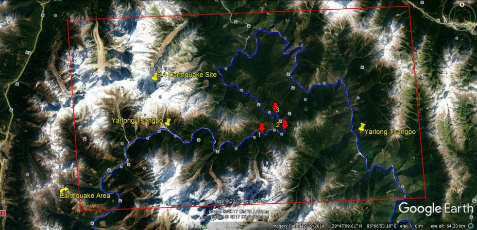
Muddy Siang is sign of danger ahead, wake up call for Indian authorities
The current ongoing episode of Muddy Siang River water in Arunachal Pradesh is due to landslides in the upstream Tibet, triggered by the earthquakes starting on Nov 17, 2017 or possibly earlier. This is revealed by the satellite pictures and work of two researchers, first published in Arunachal Times on Dec 21, 2017[i]. These landslides are partly blocking the Siang flow and could lead to massive floods in the downstream Arunachal Pradesh and Assam any day.
A similar event in year 2000 led to sudden, massive floods in Siang River in Arunachal Pradesh on June 1, 2000. That episode, like the current one, started about 53 days before the floods, on April 9, 2000 due to landslides along a tributary of Yarlung Tsangpo, as Siang is known in Tibet. Continue reading “Muddy Siang is sign of danger ahead, wake up call for Indian authorities”
