(Feature Image: A flooded housing society in Bangaluru after heavy rainfalls in Sept. 2022)
The excellent opinion piece below by Soumya Sarkar clearly explains how absence of hydrological governance has been root cause for increasing incidents of urban flooding across the country. Indeed, the urban development in India is construction centric where resilience has become a postscript rather an inbuilt feature.
The unplanned expansion is happening at the cost of open spaces, wetlands and floodplains overwhelming the drainage systems but excess rains get portrayed as the main culprit while the real ones are conveniently overlooked. The cycle is repeated as sectorial approach deals with the intertwined hydrological factors without any coordination.
The case of national capital is worth mentioning which instead of ensuring adequate flows in river has been financing destructive dams to meet the potable supply whereas the city has been damaging its water sources including lakes, ponds, floodplain and at the same time failing to use rain water, treated sewage optimally and plugging the leakages which can easily help it cater to the water demands.
Ironically, often the cities battling floods in monsoon, suffer from scarcity as they are basically designed to drain out the runoffs and not to store and harness the resource. Unfortunately, there is no immediate roadmap in sight to improve the governance, nor any instances of exemplary governance.
Indian cities drowning in crisis of governance The Floods in our metros are no act of Nature but the result of failed planning, fragmented governance and misplaced priorities eroding India’s Urban resilience. Some of the major Indian cities that faced major floods in SW Monsoon 2025 included Kolkata, Mumbai, Delhi, Prayagraj and Varanasi. What they faced was not nature’s fury but governance failure compounding climate crisis, collapse of planning, accountability and logic of public investment and not meteorological misfortune. Projections show 43% rise in extreme rainfall intensity in already systematically dismantled natural defences in the cities. Rainfall patterns have long back overtaken the changes in the design protocols, events deemed decadal earlier now happen every other year. Resilience deterioration is accelerated by institutional fragmentation. Drainage, land use and river management sit in different agencies with no one responsible for coordination between these clearly connected themes. Rapid and designed urban expansion is adding to this chaos.
As concrete and pavement replace natural ground and vegetation, stormwater runoff increases dramatically, overwhelming systems designed for a different climate and population profile. India has no unified hydrological authority capable of aligning urban infrastructure with basin-scale dynamics. Experts have repeatedly said that India’s urban governance is structured around “projects rather than systems”, where resilience is an afterthought rather than embedded in the design. Cities are losing their innate ability to absorb water. The destruction of natural infrastructure – wetlands, forests, water bodies, rivers, floodplains, that would naturally slow and store floodwaters has rendered traditional drainage inadequate. Mumbai’s and Delhi’s drainage systems, for instance, has a functional capacity of only 45 mm and 50 mm per hour, a limit that is overwhelmed almost every year now. For cities along the Ganga basin, such as Varanasi and Prayagraj, flooding results not only from riverine overflow but from local rain overwhelming drains, an issue worsened by master plans that fail to incorporate future rainfall projections.
Limited available investments are flowing into capital-intensive works like roads, plazas and underground ducts, but little goes into Ecological maintenance or restoration, rejuvenation. To live with the reality, urban India must learn to absorb water, not just repel it. A resilient city is one which learns not to remain dry, but learn become wet without drowning.
HYDRO POWER PROJECTS
Approval to Sawalkote HEP in J&K: Testing Governance: The Hindu Edit The Union Ministries of Power and Home Affairs have repeatedly stressed its strategic value to press for exemptions from impact and carrying capacity studies. But other factors cannot be wished away with a wand. The Chenab already hosts the Dulhasti, Baglihar, and Salal projects, in a “bumper-to-bumper” hydropower corridor. Ignoring cumulative impact here means underestimating compounded sediment loads and slope instability. The gravity dam proposed at Sawalkote, despite being described as run-of-river, will form a reservoir of over 50,000 crore litres, rendering it functionally closer to a storage dam. The NHPC Limited’s recent record in comparable Himalayan projects shows many schedule slippages and cost overruns. Finally, rehabilitation costs account for just 0.6% of total expenditure whereas nearly 1,500 families will have to be resettled and 847 hectares of forests will have to be diverted.
However, this approach risks diminishing India’s credibility as a riparian state that abides by treaties, particularly in fora where it advocates rule-based transboundary governance. Should India proceed with multiple large projects without cooperative mechanisms, future negotiations may potentially invite third-party scrutiny — precisely what it has long resisted. In any case, strategic assertion should come with ecological restraint, and would require regional studies and protocols to manage sediments for all future projects, regardless of treaty status. India should also institutionalise data transparency through regional or multilateral platforms, converting hydrological monitoring from a security risk into a confidence-building measure, which would also align strategic autonomy with stewardship. Sawalkote’s legacy will ultimately depend on whether India realises that national security and ecological responsibility reinforce each other.
Uttarakhand HC questions muck dumping by Vishnugad Pipalkoti HEP A division bench of the Uttarakhand High Court, comprising Chief Justice G Narendar and Justice Subhash Upadhyay, hearing a PIL on muck dumping in and around the 8th-century Laxmi Narayan Temple built in Haat village, Chamoli, directed the state’s chief secretary and culture secretary to inspect the site and submit a report by the next hearing on Oct 17. The Tehri Hydro Development Corporation India Limited (THDCIL) was also ordered to file an affidavit detailing an action plan and roadmap for debris removal. Expressing serious concern over the dumping, the court directed THDCIL to conduct an environmental impact assessment of the site and submit the report.
Haat village has been acquired for muck dumping related to the Vishnugad Pipalkoti hydroelectric project. The petitioner submitted a report from the Archaeological Survey of India (ASI), which recommends that muck dumping around the temple complex be stopped. In a previous hearing, the court noted that prima facie, the dumping could affect not only the temple complex but also the surrounding ecology. It further directed that muck dumping should cease within a 100-meter radius of the temple complex and along its approach road.
Trash floods 6 km of Nangal Hydel Canal Huge amount of plastic waste and other trash in the Nangal hydel canal has people worried here as many drinking water schemes rely on it. The trash can be seen up to 6 km from Nangal town, from where the canal starts. The canal runs for 64 km from Nangal to Ropar, thereafter it joins the Bhakra main line canal, which takes the Sutlej waters to adjoining states. The issue has come to the fore amid reports that around 100 boars were found dead due to the consumption of toxic water in the Nangal Wildlife Sanctuary in March.The sanctuary receives water from the Nangal Dam reservoir, from where the hydel canal and other water bodies originate.
According to officials of the Bhakra Beas Management Board (BBMB), which looks after the canal, the trash flowing into the Sutlej from upstream areas generally gets collected at Nangal Dam, where it is removed. However, this time, it crossed the gates of the dam and flowing into the canal, an official said without citing the reason for it. It was affecting power plants in Ganguwal and Kotla hydro power houses, situated over the water bodies.
CEA’s grand transmission plan from NE Hydro CEA has drawn up a Rs 6.4 trillion ($77 billion) transmission plan to move more than 76 GW of hydroelectric capacity from the Brahmaputra basin by 2047 to meet rising electricity demand, it said on Oct 13. In a report released on Oct 13, the CEA said the plan covers 208 large hydro projects across 12 sub‑basins in the NE states, with 64.9 GW of potential capacity and an additional 11.1 GW from pumped‑storage plants.
Phase one of the plan, running to 2035, will require Rs 1.91 trillion, while phase two will cost Rs 4.52 trillion. The plan also includes projects allocated to NHPC, NEEPCO, and SJVN, with some projects already in the pipeline. It envisages development of 31,000 circuit kilometre (a unit of length for power transmission lines that accounts for the number of circuits on a tower of transmission lines), 68 Gigavolt-Ampere (measures the power handling capacity of substations and transformers) of transformation capacity and 42 Giga Watt of HVDC (High Voltage Direct Current) in two timeframes—up to 2035 and beyond 2035.
The peak electricity demand of the seven north-east region (NER) states by the year 2036-37 is expected to be 9 GW. As of March 2025, the total Installed generating capacity in NER was 5,516 MW and most of the generation comes from hydro and gas plants. A November 2022 CEA report ‘Reassessment of Hydroelectric Potential in the Country’ had assessed that in Brahmputra basin, there is exploitable potential for 206 large hydroelectric projects with a total exploitable hydro potential of 62,726.7 MW.
DAMS
Mullaperiyar Dam: SC asks response on safety audit, decommissioning Supreme Court on Oct 13 sought responses from Kerala, Tamil Nadu and the Centre on an NGO’s plea for a comprehensive safety audit of the 130-year-old Mullaperiyar dam and remedial measures, including its possible decommissioning. A bench of CJI B R Gavai and Justice K Vinod Chandran also sought responses from National Disaster Management Authority (NDMA) and National Dam Safety Authority (NDSA) on the petition by ‘Save Kerala Brigade’, which expressed concern over the outdated dam, located in a seismic zone, posing a serious threat to the lives of 10 million people living downstream.
Appearing for the NGO, senior advocates V Giri and Haris Beeran sought “a holistic, expert safety evaluation of the dam by national and international dam safety experts and remedial measures, including its possible decommissioning”. “The 1895-built Mullaperiyar Dam, constructed with lime-surkhi mortar and rubble masonry, sits on the Periyar river in a seismic zone of high intensity and exceeded long ago its design life. Recent studies and surveys by experts show the dam in a structurally dangerous state, threatening catastrophic failure at any moment,” the NGO said.
Centre proposes restructuring in BBMB The Centre has proposed an amendment to the Punjab Reorganisation Act, 1966, to restructure the Bhakra Beas Management Board (BBMB, according to a letter sent by the Union ministry of power to the four state governments. The Centre has sought feedback from the states on the proposed amendment. According to the proposed amendment to Section 79(2)(a) of the Act, BBMB will comprise a whole-time chairperson and four whole-time members — one each from Punjab, Haryana, Rajasthan, and Himachal Pradesh — to be appointed by the central government. Currently, the board consists of two whole-time members: one traditionally responsible for power (from Punjab) and the other for irrigation (from Haryana).
This has not gone down well in Punjab as the state holds 58% share in BBMB’s water and power allocations and has historically borne the highest financial and operational responsibility for these projects. “The issue — particularly the demand by Rajasthan for a permanent seat in BBMB — has been pending for years and has been repeatedly opposed by Punjab in meetings of the North Zonal Council (NZC), which is chaired by Union Home Minister Amit Shah. Despite the lack of consensus in these forums, the Centre has now moved forward with the amendment, raising concerns over Punjab’s role as it will further dilute the state’s power in BBMB,” said a state power official, saying the move will be opposed.
Another point of concern is the lack of clarity in the proposed amendment regarding the specific roles and responsibilities of the four whole-time members. BBMB’s core functions are limited to power generation and irrigation management, and the current two-member system has been considered adequate for decades.
BBMB’s foundation lacks federal & legal legitimacy The Bhakra Beas Management Board (BBMB), established in 1976 under Section 79 of the Punjab Reorganisation Act, 1966, has long stood as a critical administrative body overseeing the Beas and Sutlej rivers and their associated hydroelectric projects. Yet, despite its integral role in managing water distribution and power generation, the board’s legal foundation remains constitutionally fragile as the PRA was enacted under Article 3 of the Constitution, which deals with the formation of new states and alteration of boundaries and names of existing states. The BBMB’s existence, devoid of a dedicated parliamentary statute grounded in robust constitutional provisions as per Article 262 read with Entry 56 of List I, raises concerns about federalism, riparian rights and the rule of law within the complex water governance framework. (Suresh Kumar)
KLIP: Will CBI probe delivery accountability? While the state government has made a one-time relaxation allowing CBI jurisdiction for the Kaleshwaram probe, the controversial order barring CBI from exercising jurisdiction in Telangana remains in force for all other cases. As political observers watch closely, the Union Home Ministry’s response will be crucial. Rejecting the probe could strengthen perceptions of BRS-BJP collusion, while approval might force an uncomfortable investigation.
For the BJP government, this decision carries significant political implications that extend beyond Telangana’s borders. The Kaleshwaram saga, initially intended as Telangana’s lifeline, appears to have now become a symbol of governance failures and financial irregularities. Whether the CBI probe will deliver accountability or become another political chess piece remains to be seen.
Properties of tainted KLIP engineers placed in prohibited list The Telangana vigilance department has placed the properties of the top irrigation engineers allegedly involved in corruption in Kaleshwaram Lift Irrigation Scheme under the prohibited list in the revenue records; after the Anti-Corruption Bureau’s (ACB) searches had revealed disproportionate assets worth hundreds of crores. The officials estimated that the assets of former engineers-in-chief Hariram and Muralidhar, and executive engineer N Sridhar were valued at over Rs 400 crore in the open market.
Polavaram ECRF Dam works to begin from Nov. 1 Along with the ECRF dam, authorities will simultaneously take up the D-Wall with the aim of completing both expeditiously. Polavaram project superintendent engineer R. Ramachandra Rao said, “We are expecting to get CWC’s approval for drawings of ECRF dam in a week. Ahead of it, we are taking up preparatory works, so that we can take up the dam works as early as possible. We intend to complete the whole project by June 2027, as instructed by CM N. Chandrababu Naidu.”
Incidentally, Polavaram project witnessed multiple spells of floods during the current flood season. The peak flood recorded a discharge of 13 lakh cusecs at the spillway. As adequate measures had been taken up in anticipation of floods, works on the Polavaram project have continued in an uninterrupted manner.
RIVERS
Spatial modelling of GW potential zones in Neyyar Basin The study confirms that morphometric parameters such as drainage density, bifurcation ratio, and relief characteristics are key indicators of groundwater occurrence, influencing infiltration, runoff, and storage capacity. By integrating detailed morphometric analysis with machine learning, this study enhances the accuracy of groundwater potential mapping, offering a robust approach for sustainable water resource management.
Community-led river restoration works Thirupudaimaruthur, on the banks of the river Thamirabarani in Tamil Nadu’s Tirunelveli district, emerged as a model village for using a hyper-local approach for river restoration. Waste from rituals in temples are frequently discarded into Thamirabarani. Agricultural runoff carries pesticides into the water and untreated domestic sewage continues to enter the river at several points. At Thirupudaimaruthur, the community has adopted a holistic approach to biodiversity conservation, integrating ecological, cultural, and social dimensions, making it a scalable model for community-led river restoration.
Hydrological Dynamics: A Case Study of the Ganga River ABSTRACT This paper discusses the summer water dynamics of the Ganga throughout its course. The study includes estimation of evaporative loss from river channels, groundwater interaction, and the role of aquifer water levels in sustaining river flow. In the middle plain segment of the river (~1200 km), a crucial region for agriculture and industry, evaporative loss is estimated to be approximately 58% of the river’s initial water volume at the segment’s start. Additionally, this segment exhibits the most significant river–groundwater interaction, with groundwater discharge increasing the river’s volume by roughly 120% compared to its initial volume at the segment’s beginning. Two decades of in situ data show stable groundwater levels across most of the central Ganga Plain, suggesting that reduced summer flow is driven by other factors such as increased human activities rather than groundwater depletion.
GW more crucial for Ganga’s summer flow The idea for the study goes back to 2011, when Maurya, during his research work on the Ganga river in Rishikesh, found that the contribution of glacier melts to the river was only about 32% of the total flow.
Although the study findings are important, it is not new information, says Abhijit Mukherjee, a professor of geology at the School of Environmental Science and Engineering, Indian Institute of Technology, Kharagpur. Mukherjee shares that groundwater is a significant source throughout the Ganga’s course. “In Varanasi, the groundwater input is about 52% to 58%, which increases to about 75% in parts of West Bengal such as Murshidabad. In some places in the lower reaches, it’s even 100% during summer,” he says.
Maurya says over-extraction of groundwater, glacial retreat, and excessive diversion at multiple stages are some of the main disruptors of the river’s flow. The study also points to reduced inflow from smaller tributaries, increased human encroachment along tributaries, and disruptions in water flow due to the dumping of large quantities of materials from religious practices and cremation ashes into the river as some of the key reasons.
“Over-extraction from the Ganga river for water supply to towns, cities, villages, and mainly agriculture is an issue. No obstruction, dam, or barrage should remove more than 50% of the natural flow of the river,” Ravi Chopra says.
To sustain the Ganga, there has to be a renewed focus on groundwater. “We need to understand how the aquifers in the Ganga plain are behaving, including groundwater storage capacity and the rate of decline of the water table. By natural processes, the aquifers discharge water into the river and hence are an important source,” Maurya explains. He also adds that rejuvenation and preservation programmes related to the Ganga should prioritise groundwater recharge.
While groundwater has been a focus for these programmes, Badola shares that recharging the groundwater, particularly rainwater harvesting structures and rural water security, has been a core part. “There are also programmes in place to conserve the rainwater, as most of it should go into recharging groundwater,” she adds.
Echoing Badola’s view, Maurya adds that to maintain the flow, it’s important to keep the tributaries in good health. There is a need to focus on maintaining secondary, tertiary, and higher-order tributaries in the Ganga basin, as they collect water from the fields and discharge it into primary tributaries, which in turn discharge into the Ganga. “If these tributaries do not function properly, it becomes a very serious issue for the sustainability of the Ganga river,” he elaborates.
However, programmes such as Namami Gange, which talk about rejuvenation, only work on the cleaning of the river, counters Chopra. “They are not paying any attention to the flow of the river. If there’s no water flowing in a river, what is the river?” he says.
To ensure a sustainable flow of the Ganga river, the study suggests that water release from dams and barriers must be increased to 20%-25% at key locations, untreated sewage discharge must be halted, and the traditional dumping of materials should be curbed. Meanwhile, the NGT initiated suo motu proceedings based on the isotope study and has directed the MoEFCC to respond to the findings.
NGT seeks detailed data on water quality of Ganga’s W Bengal stretch The matter heard on October 8,2025. In its order, the NGT directed the CPCB to disclose, within four weeks, the detailed primary data obtained from samples taken on parameters like E. coli, faecal streptococci, faecal coliform, and total coliform. These bacteriological indicators are often used by scientists to assess water quality especially in the context of contamination from faecal matter. According to the order, the government requested six more weeks for the submission of its detailed report.
According to the CPCB report submitted to the NGT on October 6, out of 42 STPs located on 30 Ganga front towns in West Bengal, 11 were found non-operational by the Board and 24 were found non-complying with respect to norms prescribed by the NGT. “However, w.r.t. treated sewage discharge norms notified by MoEF dated 13.10.2017, 17 STPs were found complying and 14 STPs were found non-complying,” the report further states. The next hearing on this matter has been scheduled on November 28.
A Kosi outside Bihar, on death row Uttarakhand’s Kosi, an important tributary of the Ramganga, is dying due to increasing pollution and waste.
Curb pollution in Yamuna before Chhath: CS to DCs Chief Secretary Anurag Rastogi has directed the Deputy Commissioners (DCs) of districts adjoining the Yamuna to ensure proper cleaning of the river and nearby drains ahead of Chhath Puja. The directions were issued during a virtual meeting held with DCs of Yamunanagar, Karnal, Panipat, Sonepat, Jhajjar, Gurugram and Faridabad.
SAND MINING
Oct 2025: 12 Drowned in Sand Mine Pit in Utangan river, Uttar Pradesh Disappointingly, the illegal sand mine pits are increasingly resulting in avoidable deaths of scores innocent human beings across the country on annual basis. Like in other cases, this preventable accident is being labeled as an unfortunate incident caused by a natural disaster. The most important questions to ask are how such a deep pit was formed in the riverbed? Why was it left in unrestored condition? Who is responsible for illegal sand mining?
Even more tragic is the prevailing official approach where the administration first squarely failed in checking the illegal mining in the river and then portraying the search operation as an achievement by recovering the mortals of innocent who died untimely due to its inaction and negligence. If this is the state of affairs, the lives of riverine people are on the mercy of such illegal sand mine pits in the country.
ED raids multiple locations in W Bengal ED teams raided offices in Kolkata’s Bentinck Street area, Lalgarh and Gopiballavpur in Jhargram district, while another search operation was conducted at the residence of a businessman in Asansol in Paschim Bardhaman district, he said. “These raids are part of our investigation into illegal sand mining. The ED operations started from early morning,” the official said.
The ED sleuths are combing through business records, financial documents, and properties linked to the racket, he said. The residence of a sand trader in Murugashol under the jurisdiction of Asansol South police station, is being searched as part of the probe, the ED official said. The businessman is accused of operating sand quarries across multiple districts and engaging in financial transactions worth crores of rupees, he said. “Allegations against him also include financial irregularities in government-owned sand ghats and illegal money laundering,” he said.
WETLANDS, LAKES, WATER BODIES
Encroachment & pollution of waterbodies in Bhilwara All necessary action should be taken by the authorities to protect the waterbodies in Bhilwara from encroachment and the discharge of untreated water, the NGT said on October 15. 2025. The matter relates to the encroachment of two waterbodies, Dharmo Talab and Fatehsagar Talab, also known as Bada Talab, in tehsil Kotri, district Bhilwara, Rajasthan.
“We make it clear that the land records disclose that Khasra numbers 2049 and 2050 are recorded as a ‘Talab’, which is Talab Fatehsagar in the settlement records. Any wrong entries done by any authority concerned without the State Notification or authority by law, shall be acted strongly and necessary punitive and disciplinary action must be taken against the official/officer concerned who were responsible for maintaining the records and to protect the public property,” said Justice Sheo Kumar Singh, NGT, central bench.
Actions taken by the District Collector, Bhilwara, and the RSPCB are to be reported to the tribunal within three weeks. The court clarified that it is the responsibility of the Zila Parishad, Bhilwara, to protect public property and ponds within its jurisdiction, and to ensure compliance with the Water (Prevention and Control of Pollution) Act, 1974. The next hearing is scheduled for November 26, 2025. The NGT had earlier, on July 9, 2025, directed the District Collector to take necessary action, but no reply has been filed yet. The Tribunal had also ordered proper demarcation and identification of the land through EIS/GPS in addition to the Zareeb method, if possible.
WATER OPTIONS
‘Neer Nira’ project for recharging of borewells The Kerala WRD has announced a new project ‘Neer Nira’ for recharging of borewells with government subsidies. The project aims to nurture groundwater sources at subsidised rates. Water Resources Minister Roshy Augustine announced the project at a seminar held as part of ‘Vision 2031’ at Kattappana on Oct.17. Officials said the department was implementing a groundwater recharging project for the first time in State. According to the groundwater resources assessment report for 2014, there are three critical blocks and 29 semi-critical blocks in the State with excess groundwater use.
GROUNDWATER
Monsoon recharges pushing more pollution into Telangana’s GW This was a disturbing finding revealed in the ‘Groundwater Quality Year Book of Telangana State, 2025’, released by the Union ministry of jal shakti recently. The report, which provides data from 2017 and 2024 for pre and post-monsoon groundwater quality for various parameters in the state, said pre-monsoon excessive fluoride levels were found in Nagarkurnool, Rangareddy, Yadadri Bhuvanagri, Jangaon, Warangal, Hanamkonda, Hyderabad, Medchal Malkajgiri & Nalgonda districts. Overall excessive levels, the report said, were predominantly found in parts of Hanamkonda, Warangal, Jagtial, Jangaon, Nagarkurnool, Karimnagar, Khammam, Rangareddy, Nalgonda districts.
It is clear that between 2017 and 2024, a significant increasing trend was observed with respect to the number of locations having fluoride more than the permissible limit. In addition to geological factors, the increasing fluoride content in groundwater in Telangana could be due to “anthropogenic (human) activities which include excess use of fertilisers, and industrialisation,” the report said. Another vital parameter — electricity conductivity — in groundwater which is impacted by presence of total dissolved solids, also showed a rise post-monsoon. Of the 363 locations from where samples were analysed for this property, it was found that this rose in 170 locations.
Fluoride contimination: NHRC warns Telangana The National Human Rights Commission (NHRC) has warned the office of the Chief Secretary over failure in filing an action taken report on tackling fluoride contamination in groundwater. The Commission said that the complainant submitted that Groundwater in Telangana is found to contain excess fluoride levels, posing serious health risks.
URBAN LAKES, WETLANDS
Citizens continue a decade-long fight to conserve an urban lake The 30-acre DPS Flamingo Lake in Navi Mumbai, a crucial wetland for migratory flamingos, faces severe conservation challenges. Residents and environmental groups have been campaigning for the lake’s recognition as a “conservation reserve.” While Maharashtra’s Forest department and local authorities have acknowledged the issue, the City and Industrial Development Corporation’s development interest threatens the conservation of DPS Flamingo Lake, locals say.
URBAN WATER
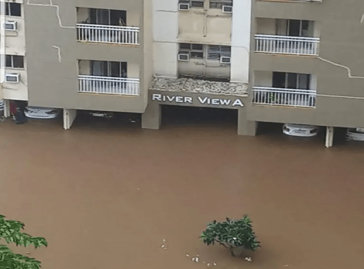
Indian cities drowning in crisis of governance The Floods in our metros are no act of Nature but the result of failed planning, fragmented governance and misplaced priorities eroding India’s Urban resilience. Some of the major Indian cities that faced major floods in SW Monsoon 2025 included Kolkata, Mumbai, Delhi, Prayagraj and Varanasi. What they faced was not nature’s fury but governance failure compounding climate crisis, collapse of planning, accountability and logic of public investment and not meteorological misfortune. Projections show 43% rise in extreme rainfall intensity in already systematically dismantled natural defences in the cities. Rainfall patterns have long back overtaken the changes in the design protocols, events deemed decadal earlier now happen every other year. Resilience deterioration is accelerated by institutional fragmentation. Drainage, land use and river management sit in different agencies with no one responsible for coordination between these clearly connected themes. Rapid and designed urban expansion is adding to this chaos.
As concrete and pavement replace natural ground and vegetation, stormwater runoff increases dramatically, overwhelming systems designed for a different climate and population profile. India has no unified hydrological authority capable of aligning urban infrastructure with basin-scale dynamics. Experts have repeatedly said that India’s urban governance is structured around “projects rather than systems“, where resilience is an afterthought rather than embedded in the design. Cities are losing their innate ability to absorb water. The destruction of natural infrastructure – wetlands, forests, water bodies, rivers, floodplains, that would naturally slow and store floodwaters has rendered traditional drainage inadequate. Mumbai’s and Delhi’s drainage systems, for instance, has a functional capacity of only 45 mm and 50 mm per hour, a limit that is overwhelmed almost every year now. For cities along the Ganga basin, such as Varanasi and Prayagraj, flooding results not only from riverine overflow but from local rain overwhelming drains, an issue worsened by master plans that fail to incorporate future rainfall projections.
Limited available investments are flowing into capital-intensive works like roads, plazas and underground ducts, but little goes into Ecological maintenance or restoration, rejuvenation. To live with the reality, urban India must learn to absorb water, not just repel it. A resilient city is one which learns not to remain dry, but learn become wet without drowning.
SEAC, SEIAA restored The Centre has reconstituted two key environmental clearance (EC) bodies of Delhi, a year after their terms ended, officials said on Oct. 13. The State Level Environment Impact Assessment Authority (SEIAA) and State Level Expert Appraisal Committee (SEAC), whose tenure ended on September 5 last year, have been reconstituted for a period of three years, a gazette notification dated October 9 stated.
Experts meanwhile said the reconstitution was long overdue. “For far too long, environmental clearances had been trapped between bureaucratic delay and inadequate scrutiny. The reconstitution of SEIAA and SEAC is a positive sign, but we also need sustained focus moving ahead, which includes accountability and public participation,” said environmental activist Bhavreen Kandhari.
DJB plan to seek Ganga water from UP According to officials, city currently produces about 990–1,000 MGD of potable water, up from 927 MGD in 2020-21. Yet, the latest economic survey places demand at nearly 1,290 MGD, leaving a shortfall of almost 300 MGD. To bridge part of this gap, the DJB has sought 50 MGD of raw Ganga water from UP and, in return, offered to supply 100 MGD of treated water.
The treated water, processed in Delhi’s sewage treatment plants, has been proposed for non-potable uses such as irrigation in agriculture and landscaping of public spaces like parks and gardens. “No decision has been taken yet, but discussions are in progress,” a DJB official said. At present, the capital draws about 240 MGD of water through the Upper Ganga Canal.
The Delhi government has also begun drafting a new water policy, its first since 2016. Officials said the exercise focuses on modernising infrastructure, expanding production capacity, and addressing the persistent imbalance between supply and demand. The DJB has been directed to study reports and assessments from the past 10–15 years on water transport and management to guide this framework. Apart from sourcing more raw water, the utility is also working to plug losses in the transmission network. Officials noted that minimising leakages and optimising distribution are as critical as expanding production to ensure the capital’s long-term water security.
Govt announces waiver CM Rekha Gupta announces big water bill waiver, penalty on legalising water connection cut by 96%.
Vadodara citizens livid about water contamination Residents of the Ektanagar neighbourhood in Chhani vented their ire at senior health department officials, saying no action was being taken about the supply of contaminated water to the neighbourhood by the Vadodara Municipal Corporation (VMC). The residents say the contamination caused an outbreak of waterborne diseases.
With more than 70 cases of waterborne disease reported in the past week, officials decided to visit the area. Most cases were of diarrhoea and vomiting. Health officials have recorded 46 suspected cases of typhoid in the locality over the past few days, sparking anger and anxiety among citizens. After residents said they were being supplied yellowish, contaminated water. The residents say the supply pipelines have leaks as they are very old.
WATER POLLUTION
Uttarakhand Contaminated water killed 9 in Almora villages A sudden outbreak of fever has swept through at least five villages – Devlibagad, Viwadi, Dhuratak, Mala and Kheti – killing nine people and leaving more than 50 seriously ill. What began as a bout of fever, initially dismissed as the result of changing weather, soon turned deadly. Within days, elderly residents began dying as their condition deteriorated rapidly. “Most of the deceased were between 50 and 70 years old,” said Ganesh Pandey, a resident. “Entire families were falling ill at once, and hospitals are too far away. By the time help arrived, it was too late.”
Once the deaths drew the attention of the health department, teams of doctors were dispatched to the affected areas. Tests revealed that the cause was not a mysterious new disease, but a bacterial infection spread through contaminated drinking water. Investigations showed that the water tanks supplying the villages were polluted with coliform bacteria – an indicator of faecal contamination, capable of spreading illnesses such as typhoid, diarrhoea and cholera.
MP: 60 fall ill after consuming contaminated water from a well in Chhindwara SDM Chhindwara, Hemkaran Dhurve, said, “We had conducted a check-up of 150 families yesterday. 60 people from 150 families were found suffering from vomiting and diarrhea. We took water samples from the well and found them to be contaminated. Four pigeons were found dead in the well. Immediately we closed the well and today we will change the water of the well with fresh water.” He also said, “Today, 120 patients have been administered medicine and our medical camp will be set up here for the next 2 to 3 days. No patient is in serious condition and we have made temporary hospital to Gram Panchayat. Action will be taken for negligence by the Gram Panchayat, Pump operators and Secretary.”
AGRICULTURE
Costs of Ethanol Blending Beneath the triumphalist narrative of energy sovereignty and rural prosperity, India’s achievement of 20% ethanol blending five years ahead of target is shaped by more complex trade-offs involving the economics, ecology, and food security of a nation of 1.4 billion. Data as of mid-2025 indicates ethanol and sugarcane companies have seen a healthy ride in profits and market cap.
Farmers and industries are guzzling water, already a scarce resource. Sugarcane, the backbone of the program, requires a staggering 60–70 tonnes of water per tonne of cane harvested, ranking among the most water-intensive crops. Perhaps the most problematic dimension is the program’s effect on how grains are used. According to estimates, nearly 5.2 million tonnes of rice and about a third of India’s maize output were redirected to ethanol. The knock-on effects are measurable: maize prices soared 22% in FY23–24, and after nearly twenty years, India became a net maize importer — an ironic twist for an initiative meant to curb foreign dependencies.
In E20 blends (20% ethanol), this causes a 2–7% mileage drop, varying by engine tuning, driving style, and vehicle age. Modern flex-fuel engines lose 2–4%, older ones up to 7%, though higher octane can offset some losses in performance-oriented engines. This negates much of the purported price advantage. the large capital requirements favour big established companies. Of the 180 distilleries operating nationally, the top 15 control nearly 60% of total output. This concentration has sidelined smaller mills and newer entrants. With profits surging across major producers, questions about the longevity and rationale of government support arise.
Dyring Ganga plains Analysis of monsoon data pertaining to the past 45 years by the Indian Institute of Tropical Meteorology has revealed that while rainfall has shown an increasing trend in northwest India, there has been a decline in the Gangetic Plains – considered the food bowl of India. This has serious implications not only for food security, but also impacts irrigation infrastructure and groundwater resources.
DAM FLOOD 2025
Did Ichari, Vyasi dams influence Yamuna floods in 2025? There are two big dams Ichari on Tons and Vyasi on Yamuna and three barrages – Dakpathar on Yamuna, Asan on Asan river and Jateon barrage on Giri river in Yamuna basin in Himalayan segment which have potential to influence the natural flooding pattern of the river.
The analysis suggests that sudden discharges (possibly for silt flushing) from Ichari & Vyasi dams in Yamuna led to increased flow in the river downstream during some periods. The filling of dams then resulted in reducing the natural flow of the river.
Since, these dams, barrages have potential to turn a natural flood into disasters, their discharge data and operational procedures need to be in public domain in order to ensure their transparent and accountable operations during monsoon season.
3 drowned in Yamuna Villagers said the river’s deadly currents are worsened by whirlpools formed due to an unused barrage built by the Uttar Pradesh government in the 1980s. These hidden whirlpools make the river treacherous, particularly for those performing sacred rituals. Minister Harshwardhan Chauhan visited Gwali village to console the grieving families. Expressing deep sorrow, he shared that long-term safety measures, including barricades, warning boards, regulated bathing zones and permanent deployment of professional divers, will be implemented.
He also said the matter would be taken up with the Uttar Pradesh government to dismantle the unused barrage causing whirlpools, ensuring such tragedies are never repeated. The grief at Paonta Sahib is not new. In the past two decades, more than 60 people have lost their lives at this Ghat.
Compensation demand for Himayat Sagar water release affected in Hyderabad Members of Hyderabad Civil Society, along with affected residents from several flood-hit localities have written to the Telangana govt with grave concern and deep anguish over the sudden and large-scale release of floodwaters from the Himayat Sagar reservoir on the night of 26th September 2025, around 9:00 pm and have demanded compensation. This unannounced release caused catastrophic flooding across Moosa Nagar, Vinayak Veedhi, Kamal Nagar, Rasoolpura, Shankar Nagar, Shivaji Bridge, Purana Pul, Kishan Bagh, Moghal Nala A & B, Defence Colony, Langar House, Jiyaguda, Attapur Bridge, Hashim Nagar, and surrounding areas, directly affecting over 6,000 families, the letter says. The lack of timely warnings, coordination, and precautionary measures has devastated homes and livelihoods, they write.
FLOOD
Changing magnitude & timing of riverine floods in India Abstract Riverine floods are one of the most frequent and destructive types of natural hazards globally. Although India has densely populated floodplains, national-scale trends in flood discharge observations remain largely unknown. Using representative streamflow records, we assessed changes in flood magnitude and timing across India with the modified Mann–Kendall test and Theil-Sen’s Slope Estimator. Results show a decreasing trend in flood magnitude at 74% of gauging stations, and regional variations in flood timing. We further examined links between continental-scale climate signals and flooding by analyzing precipitation and soil moisture patterns in identified hotspots. Declining precipitation and soil moisture reduced monsoon flood magnitude by 17% per decade in the West and Central Ganga basin, while rising pre-monsoon rainfall increased flood magnitude by 8% per decade on the Malabar coast. Early precipitation in the lower Yamuna and delayed precipitation in the Upper Ganga advanced and postponed floods, respectively. Flood discharges were dampened in arid basins, and large catchments experienced reduced flood magnitudes. These insights enhance our scientific understanding of flood dynamics and support targeted policy and disaster management strategies across India.
Extraction, floods underline North Bengal’s climate debt Catastrophic floods and nearly 100 landslides in early October exposed North Bengal’s fragile ecology. Decades of unregulated sand mining, deforestation and hill-cutting have destabilised rivers and slopes. Rapid urban expansion in Siliguri and Darjeeling is eroding farmland and forest cover at alarming rates. The 2023 Teesta dam disaster and glacial lake floods underline the region’s growing climate vulnerability. Experts warn North Bengal has entered a “climate crisis” stage, demanding urgent action beyond token relief.
HIMALAYAN ECOSYSTEM
Recognise the Value of Himalayan Ecosystem, contribution to nation According to a 2025 report of the Institute of Forest Management, Bhopal, the total forest wealth of Himachal was valued at Rs 9.95 lakh crore. The report calculated the annual Total Economic Value (TEV) of Himachal’s forests at Rs 3.2 lakh crore; this includes Rs 1.65 lakh crore for carbon sequestration, Rs 68,941 crore for eco-system services, Rs 32,901 crore as the value of bio-diversity, Rs 15,132 crore for water provisioning, Rs 3,000 crore for regulatory services such as flood control and sediment retention. These contributions benefit the whole nation, not just Himachal. Unfortunately, these are neither acknowledged nor taken into account while disbursing Central assistance to the states.
Release of this money should be indexed to improvement in environmental parameters, sustainability of development and tourism projects, protection of rivers and curbing of illegal mining and construction. In fact, the Supreme Court, which is holding suo motu hearings on the environmental devastation in Himachal and has said that at this rate the state would “vanish from the map of India”, should also consider this issue and nudge the Centre to create such a fund. If the Himalayas lose their forests, rivers and glaciers, it won’t be long before North India goes the way of the Indus Valley Civilisation. (By Avay Shukla)
HIMALAYAN DISASTERS
People For Himalaya calls for reforms in disaster governance The statement, issued under the banner of the People For Himalaya campaign, comes in the wake of the catastrophic monsoon disasters of 2025 that exposed the deep ecological fragility and governance failures across the mountain states. The People For Himalaya campaign stresses that the Himalayan disasters of 2025 must mark a turning point in India’s approach to disaster governance. The statement concludes that the only viable path forward is one that centres on safety, equity, and environmental integrity, supported by adequate funding, scientific planning, and empowerment of mountain communities.
Carrying capacity for sustainable tourism practices in the Char Dham The present study evaluates the eco-tourism potential and sustainable tourism initiatives in the Char Dham (four shrines) in Uttarakhand state, where tourist numbers have grown from 1 million annually in the early 2000s to over 3 million recently, with a record 5 million visitors in 2023. Key findings of the work revealed the tourist carrying capacity of the areas with sustainable daily limits of 15,778 for Badrinath, 13,111 for Kedarnath, 8178 for Gangotri, and 6160 for Yamunotri Dham.
The researchers caution that carrying capacity estimates should be dynamically updated as infrastructure and environmental conditions evolve, emphasizing that only a community-driven, scientifically informed approach can secure the future of the Char Dham as both a sacred and sustainable destination.
Fund resilience, not disasters, by empowering vulnerable communities The global call this year: “Fund Resilience, Not Disasters”, shift investments towards prevention, livelihoods, and local leadership.
Early Warning for All -WMO has welcomed a declaration by the Group of 20 (G20) ministers which gives strong recognition to the need for multi-hazard early warnings and the essential role of National Meteorological Hydrological Services as the authoritative warning provider.
WORLD
Over 60% of world’s river dammed or diverted Over 60% the world’s Rivers have been dammed or diverted and urban growth is putting food, water, biodiversity and livelihoods at risk unless urgent action is taken, according to the Global Land Outlook Thematic Report on Ecological Connectivity and Land Restoration. It was launched at the International Union for Conservation of Nature (IUCN) World Conservation Congress in Abu Dhabi. Nearly one-third of the Earth’s land surface has already been profoundly transformed by human activity, leaving ecosystems degraded and fragmented, said the report.
Produced by the United Nations Convention to Combat Desertification (UNCCD) and the Convention on the Conservation of Migratory Species of Wild Animals (CMS), the study shows that Earth’s landscapes are interconnected like a living mosaic, held together by the movement of species and the natural flow of water, nutrients and energy. But today, these lifeline networks of rivers, forests and grasslands are increasingly under threat, disrupting and diminishing the functioning of natural systems.
Commenting on the findings, UNCCD Executive Secretary Yasmine Fouad said, “Life on our planet depends on healthy land and water systems–not only for nature, but for people. When these ties are broken, it is the most vulnerable who suffer first. This report shows that restoring ecosystems also means restoring the links between them.” “When landscapes are restored at scale, they also lock away carbon, reduce disaster risks, protect biodiversity and create jobs,” it states.
SANDRP
