(Feature Image: The release of water from Pong Dam has brought devastation to Mand Bhograwan village in Kangra district, where the sudden rise in the Beas river has submerged several acres of fertile land and put houses at risk. Aug 17.)
Sudden release of large quantity of water from the dams has the potential of creating avoidable floods in the downstream areas as we could see last week in case of Ukai Dam water releases affecting Surat in South Gujarat, Ujani and Jayakwadi dam water releases in Maharashtra, Bhakra and Pong dam releases in Punjab and Himachal Pradesh, among others. In all these cases, we can show that earlier water release was warranted based on available information, considering the carrying capacity of the downstream river, but such action was delayed till either the dam was full before water started (e.g. Ujani and Jayakwadi) or too large water releases created avoidable flood impacts in case of Ukai Dam on Tapi River in South Gujarat and also in case of Bhakra and Pong dams. There were also extensive damages in Mirzapur and Chandauli districts of Uttar Pradesh due to sudden release of water from a number of dams including Chandra Prabha Dam, Ahraura dam and Jargo Dam among others.
The Himachal Pradesh Chief Minister has rightly directed the HP Energy Department to file First Information Report against BBMB, others for violating the dam safety norms and BBMB & others must compensate for the resultant losses. We hope this is taken to its logical conclusion and more such action is taken up in case of other such avoidable water releases.
In this context it is also important that dam authorities keep the carrying capacity of the downstream river and state of its floods in downstream rivers in mind while deciding about water releases. The respective state governments must ensure that rivers continue to have adequate carrying capacity through policies and effective regulations.
DAM FLOODS
Pong Dam Releases floods Hoshiarpur and Kangra The Pong Dam on Beas river in Himachal Pradesh started releasing 57221 cusecs water at 9 am on Aug 17 when water level in the dam reached 1379.98 ft, flooding the riverine areas in Kangra (Himachal Pradesh) and Hoshiarpur (Punjab). Inflow into the dam was 109789 cusecs. 17620 cusecs is being releases through turbines and 39601 cusecs through spillway. People were evacuated from a number of villages in Kangra as water entered houses.
Bhaskar 190825: Pong dam water level 1383.11 ft, with FRL 1390 and MWL 1410 Ft. Releases to increase to 75000 cusecs on Aug 20 morning from 60000 Cusecs now as inflow is 1.5 lakh cusecs.
HP FIR Against BBMB over excess water release from Pong Dam Speaking in the Himahal Pradesh assembly, CM Sukhvinder Singh Sukhu said that continuous discharge of water from the Pong Dam on the Beas has created a flood-like situation in Fatehpur and Indora regions of Kangra district. He informed the House that a first information report (FIR) was registered against the BBMB management at the Sansarpur Terrace police station in Kangra on July 26 for its alleged failure to ensure dam safety protocols. “Despite repeated devastation, including the 2023 floods, BBMB has neither compensated victims nor created safeguards. Our people are paying the price,” said the CM.
Congress MLA from Indora Malender Rajan said that 12-13 panchayats were hit, nearly 100 people rescued, 42 schools shut and critical infrastructure washed away. “In 2023, the BBMB released 1.42 lakh cusecs without warning, destroying more than 10,000 hectares. Yet it has not installed a proper early warning system,” he said. Congress MLA from Fatehpur (Kangra) Bhawani Singh Pathania demanded that the area downstream Pong Dam should be declared as no mining zone. He pointed out that this illegal mining is also leading to flooding in the area.
Responding to a calling attention motion of Congress MLA Malender Rajan, Sukhu said that crops in 50-60 hectares of land & crops, four houses and 38 cow sheds were completely damaged and 4 houses were partially damaged in Fatehpur. A total of 23 families, having 107 members, have been shifted to safer places. In Indora assembly segment, 100 hectares of agricultural land was washed away. Several villages there were cut off due to closure of roads and damage to two bridges.
FIRs filed against BBMB, others On the directions of the HP CM, the Himachal Energy Department has initiated First Information Reports (FIRs) against BBMB in Kullu, Kangra and Mandi districts. Of the five FIRs, three have been registered in Kangra and one each in Kullu and Mandi districts, based on detailed complaints filed by the Chief Engineer of the Energy Department. The cases pertain to the Pong Dam, Pandoh Dam, Parbati-III and Malana-II projects, where sudden and unregulated water discharge caused widespread damage and panic in areas downstream during the monsoon seasons of 2023 and 2025.
The FIRs cite violations under several sections of the Bharatiya Nyaya Sanhita (BNS), the Disaster Management Act, 2005, and the Dam Safety Act, 2021, which even entail imprisonment. The complaints accuse BBMB officials of failing to implement adequate early warning systems (EWS) despite repeated notices, and ignoring critical safety guidelines issued over the years.
Despite years of official communication dating back to 2015 and urging the BBMB to enhance its alarm and notification system, the agency allegedly failed to take corrective measures. The Directorate of Energy’s committee reports, submitted after thorough technical inspections in October 2023, found the BBMB’s safety measures “grossly inadequate”.
The state government has demanded that the BBMB immediately implement the full provisions of the Dam Safety Act, 2021, warning that further non-compliance will invite stricter legal consequences.
Bhakra water release: Punjab farmers fear repeat of 2023 Releasing 18000 cusecs against inflow of 1.29 lakh cusecs, water level is 1664 ft, FRL 1680, gates start at 1645 ft. (The Hindustan Times 190825)
As per the rule curve till August 19th the water level at Bhakra Dam should have been 1662 feet. However, it was 1665 feet. The floodgates of the dam were opened (for the first time this monsoon) at 3 pm by one foot, at 4 PM by two feet & at 5 PM up by three feet including radial and flood control gates. The BBMB would release about 45000 cusecs water on Aug 19 from Bhakra Dam: 22000 cusecs would be released in the Sutlej river which the remaining 23000 cusecs would be released in Nangal Hydel canal that later connects with Bhakra main line and Anandpur Sahib hydel canal which ultimately joins Sutlej river near Kiratpur Sahib. Inflow is 70500 cusecs. The gates were last opened on Aug 13 2023.
– On Aug 20: Water level at 1665.06 ft, against rule level of 1662 ft.
– On Aug 21: Water level 1666.32 ft.
At 6 am on Aug 21, 51,000 cusecs of water were released from Ropar (Bhakra Dam) into the Sutlej. As per the district administration, it generally takes around eight hours for the water level to impact the Ludhiana district, where there are about 11 main flood vulnerable points from where villages could face floods. Ludhiana Deputy Commissioner said there is no risk Sutlej flow crosses 1.4 lakh cusecs in Ludhiana. The water releases continued till Aug 24 and there is no plan to stop it as of now.
Ranjit Sagar Dam The Ranjit Sagar Dam on the Ravi river in Punjab, has the water level of 1,712 feet on Aug 19. The water inflow is 41,300 cusecs.
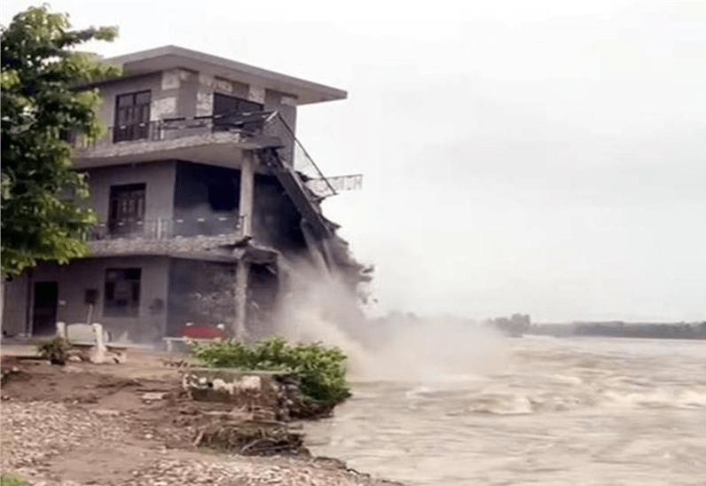
Water releases from dams cause flash floods in Chandauli, Mirzapur On Aug 23, around 10,000 cusecs of water was released from Chandraprabha Dam in Chandauli district and 21 gates of Ahraura Dam were opened on Saturday in Mirzapur, leading to a flood in Jamalpur area, affecting more than 24 villages. Eight gates of Jargo Reservoir in Chunar of Mirzapur were opened, resulting in flood in areas including Bharpur and Lal Darwaza.
16 gates of Ahraura Dam were closed on Aug 24 afternoon and the orders were issues to close the rest on Monday. Mirzapur DM said after visiting the area that the water released disrupted transportation in several villages and caused difficulties for the people. Relief operations have been launched in affected villages by ensuring boarding arrangements in school buildings for those who needed relocation due to the inundation of their areas. Officials assured farmers who lost crops that they will be compensated. For poor families who lost their homes, he said, CDO was instructed to engage all block development officers to include them in the Chief Minister’s Housing Scheme to rebuild their homes.
Chandauli DM Garg said, “Due to incessant rainfall in hilly areas of the district, approximately 10,000 cusecs of water have been released from Chandraprabha Dam and 25,000 cusecs from Naugarh Dam, affecting about 15 villages.”
Tungabhadra Dam releases 80000 cusecs, flood threat in downstream Tungabhadra started releasing 80000 cusecs water from Aug 17 noon. Out of the dam’s 33 crest gates, seven are fully jammed and eleven are partially jammed, limiting the discharge of water. The replacement of the crest gates will commence after Nov, and is expected to take a minimum of eight months to complete.
Jayakwadi dam storage 95% The Jayakwadi dam in Maharashtra is already 95.05 % full on Aug 20 afternoon. Water outflow from spillway have not yet been started.
Mettur dam full for the fifth time this year The Mettur dam on Cauvery River in Tamil Nadu has been filled upto the full reservoir level of 120 ft on Aug 20 for the fifth time this year. This has happened for the first time in 68 years.
Linganmakki Dam 94% full, releases 15000 cusecs The Linganmakki Dam in Shivamogga district in Karnataka reached 1816.2 ft on Aug 19, that is about 94% full against full capacity of 1819 ft. It started releasing 15000 cusecs of water from 11 gates of its spillway. Inflow was 48393 cusecs. The dam is full for the 15th time since 1964 when it was commissioned.
1.5 L cusecs released from Ujani dam:Flood alert in Pandharpur The water discharge rate from Ujani dam (storage already 100% of its capacity) into the Bhima river was increased to 1.5 lakh cusec on Aug 21 (from 90 000 cusecs on Aug 20, 1.3 L cusecs on Aug 21 morning), leading to a flood alert for the temple town of Pandharpur in Solapur district. The situation was further aggravated because the said river also receives water discharged from Veer dam, which released 13000 cusecs on Aug 21. Veer dam is located near the areas of Shirwal and Khandala on the border of Pune and Satara districts on the Nira river.
It was the first time this season that water was released from Ujani dam on such a large scale. Officials from the state irrigation department said the sudden increase in discharge was mainly because of inflow of high volume of water from upstream dams in Pune district. Since the last three days, dams around Pune have been releasing water. Khadakwasla released water at a rate of 39,000 cusecs, while Mulshi and Pavana collectively discharged water at a rate of 35,000 cusecs on Aug 20. z
Ukai level near rule, huge inflows expected Ukai Dam authorities have started the release of water. For the first time this monsoon all four 75MW hydropower turbine units became operational. Total discharge from the dam was around 24,500 cusecs. The water level reached 334 feet on Aug 18, a foot below the rule level of 335 feet for the second half of August. Inflows rose above 80,000 cusecs and came down to 60,725 cusecs late in the evening. Of the dams in Maharashtra, Hatnur released 53,855 cusecs and Prakasha 48,197 cusecs, with the water to reach Ukai within a few hours.
On Aug 20, nine gates of Ukai dam were opened (7 gates by 7 ft and two gates by 8 ft) to release 1.25 lakh cusecs water, ten villages in the downstream have been put on alert. Inflow was 1.39 lakh cusecs. Water level in Ukai dam has reached 334.77 ft. Haripura causeway in Bardoli was submerged in water.
According to this ABP news report on Aug 19 2025 at around 11 am: 9 gates of Tapi Dam have been opened for the first time in this monsoon, 8 of them by 5 ft and one by 4 ft, releasing 98739 cusecs. Water level at the dam is 334.64 ft, with inflow of 1.27 lack cusecs.
The release of 1.25 lakh cusecs of water from the Ukai dam (report dated Aug 20) has caused the river to overflow its banks, the entire district has been put on red alert for the next 48 hours. Once a vital link for daily commuters, the weir-cum-causeway connecting Rander and Singapore is now submerged under a raging torrent of water. The danger level for the causeway is 6 meters, but it is currently overflowing at a dangerous 8.32 meters.
The continuous flow of water from the Ukai dam has sent alarm bells ringing among authorities. Parts of the city, including Katargam, Dabholi, Vedroad, and Singanpur, are struggling with knee-deep water. Local shopkeepers and motorists are facing immense hardship as roads become impassable, disrupting traffic and daily routines. The city is grappling with a waterlogged situation that has thrown daily life into chaos.
BARGI DAM (NVDA):RESERVOIR DATA
F.R.L =422.76M Live capa. at FRL=3180 MCM(100%)
On 25/08/2025 at 12:00Noon, W.L: 422.55 M: LIVE CAPACITY: 3136.5 Mcum (98.63%)
Av.Inflow= 2654 CUMEC
DISCHARGE THROUGH :
RBPH Q = 198 CUMEC
Gate Q = Nill
LBPH Q= 23 CUMEC
LBMC Q= 12 CUMEC
RBMC Q= 25 CUMEC
Total Q = 258 Cumec
TOTAL Q in the river = 198 CUMEC
All gates are Closed. (sent by Rajkumar Singh of Bargi Badh Sangharsh Samiti, Jabalpur)
HYDRO POWER PROJECTS
SUMP Amid government’s efforts to convince communities for the mega hydro power project on the Siang river, those against it are invoking their “age old divine ties” with the river to oppose construction of the proposed large dam that aims to curb the “threat” from China. A large number of people belonging to the Tani clan held a General Bogum Bokang Kebang (GBBK), a traditional event, at Geku village in Siang district on Friday in which the Siang river was declared as Ane Siang or Goddess Siang like the Ganga or the Yamuna is considered by many in rest of the country.
No CEA clearance required for PSPs The Ministry of Power, through a notification published on Aug 20, exempted off-stream closed-loop pumped storage projects from seeking mandatory approval of the Central Electricity Authority (CEA). The government aims to triple approvals for pumped hydro storage projects this fiscal. However, any hydro project scheme with a capital expenditure of over Rs 3,000 crore will require concurrence from the CEA, so as to ensure that large projects undergo proper scrutiny before implementation.
J&K Small Hydro Bids “The Jammu and Kashmir government has in June 2025 put 46 new hydropower projects to bid, drawing an encouraging response from private players. Advertised projects include 26 schemes under the Swiss Challenge mode and 20 under the Independent Power Producer (IPP) route, with a cumulative capacity of 78.65 MW. 73 bids have been received for Swiss Challenge projects and 25 companies have expressed interest in IPP sites.”
DAMS
Decisions of EAC meeting held on Aug 14 2025 1. 2220 MW Oju Hydro-Electric Project at Village Reddi, Tehsil Limeking Circle, District Upper Subansiri, Arunachal Pradesh by Oju Subansiri Hydro Power Corp Pvt Ltd – Environmental Clearance: Postponed on request of PP
2. Chhadgada Closed Loop Pumped Storage project (900 MW) in 292.4Ha located Village Chhargarh, Deoghat, Devhat & Katra, Sub-district Koraon & Lalganj, District Prayagraj & Mirzapur, Uttar Pradesh by GSC PSP Uttar Pvt Ltd – Terms of Reference: Postponed on request of PP
3. Pailani Barrage on Ken River under Ken Betwa Link Project in an area 287 Ha at Village Achhraund, Laraka Purwa, Adari etc. Sub- district Banda, Maudaha & Hamirpur, District Banda & Hamirpur, Uttar Pradesh by Ken Betwa Link Canal Construction Division-1, Mahoba Irrigation and Water Resources Dept, Uttar Pradesh – Terms of Reference: More Info Sought
4. Medium Irrigation Project to Various Panchayats of Jawalamukhi (CCA: 2590 Ha) in 17.89 Ha Village Salasi, Kotla, Kotu Dhorian (869) and etc., Sub-district Nadaun, Jawalamukhi, Khundian & Dera Gopipur etc., District Hamirpur & Kangra, Himachal Pradesh– Terms of Reference: Deferred on PP request
Agenda of EAC meeting held on Aug 29 2025 1. Kamalapadu Closed Loop Pumped Storage Project (950 MW) at Village Attiraladinne, Kamalapadu & Kundanakota etc., Sub-district Peddapappur & Yadiki, District Anantpur, Arunachal Pradesh by M/s Andhra Pradesh PowerGeneration Corp Ltd – Env Clearance
2. Jankhai Closed Loop Pumped Storage Project (1500 MW) in 427 Ha at Village Kathmana, Janakhai etc, Sub-district Sirmour and Jawa. District Rewa, Madhya Pradesh by GSC PSP Madhya Pvt Ltd –Terms of Reference
3. Koppolu Open loop Pumped Storage Project (2400 MW) in 332.73 Ha at Village Koppolu, Sub-district Kondapuram, District Y.S.R., Andhra Pradesh by Chinta Green Energy Pvt Ltd: ToR
4. Rewa Closed Loop Pumped Storage Project (600 MW) in 449.47 Ha Village Nevrhiya, Uprohit Pura, Bajara, Chaura & Chhataini etc., Sub-dist Teonthar & Hanumana, District Rewa, Madhya Pradesh by Dhakara Energy Psp Pvt Ltd – Terms of Reference
5. Sonpura Major Micro Irrigation Project (CCA: 19410 Ha) in 1042.9Ha Village Akhai Mahadev, Panwari, Parnakheri & Garkatu etc., Sub-dist Badarwas, Kolaras & Guna, Dist Shivpuria and Guna, Madhya Pradesh– Terms of Reference
6. Integrated Anandapur Barrage Project (CCA: 60,000 Ha) in Keonjhar district, Odisha by M/s Department of irrigation, Govt. of Odisha – Amendment in Environmental Clearance
Relevant agenda of FAC meeting on Aug 25 2025– RE-DIVERSION OF 44.97 HA (ORIGINALLY PROPOSED AREA IS 36.4 HA) OUT OF 70.00 HA PATIARI DAM ALREADY DIVERTED RESERVOIR AREA FOR RESTORING THE RESERVOIR’S ORIGINAL CAPACITY & FURTHER PROCESSING THE DESILTED MATERIAL, HOSHIARPUR DIST, PUNJAB
DAM SAFETY
Polavaram on edge of another disaster? The Polavaram project is on the edge of disaster due to a major slide continuing in its upper cofferdam, raising fresh concerns. The under-construction project, battered by continuous rainfall and a flood surge of nearly 8 lakh cusecs in the Godavari River, has suffered another setback. The upper cofferdam is crumbling. The slide, initially reported to be 10 feet wide and 7 to 8 feet deep, has worsened. Despite emergency repairs, officials’ claims of stabilizing the impacted cofferdam have proven misleading, raising doubts about the structure’s ability to withstand ongoing flood pressures. The recurring structural failures have sparked concerns about the project’s construction quality and its ability to withstand the Godavari’s frequent floods.
The Hyderabad Intellectuals Forum alleges that contractors, labourers and media brokers had united to shield the Polavaram project from scrutiny.
HMWSSB General Manager (Engineering) A. Ramakrishna has refuted false reports regarding the malfunctioning of crest gates at the Manjeera dam. After inspecting the site with other officials, Ramakrishna confirmed that all gates were operating properly and clarified there was no threat to their functioning.
INTERLINKING OF RIVERS
6th Consultation meeting At the 6th consultation meeting convened by the National Water Development Agency (NWDA) at Jala Soudha here on Aug 22 to arrive at a consensus for implementation of Godavari-Cauvery Link Project, the Telangana Irrigation officials wanted to have liberty to use 74 tmcft anywhere from the river in the state.
Why is Telangana Congress Govt backing Inchampalli dam as Godavari Diversion Point? The Congress government’s backing of Inchampalli Dam as the Godavari diversion point has triggered concerns in Telangana. Farmers, experts and opposition parties fear the move could submerge Medigadda, cripple the Kaleshwaram project and jeopardise the State’s water security. It prioritises political motives over Telangana’s agricultural interests, threatening the Medigadda, Annaram, Sundilla and other downstream irrigation projects.
The proposed Inchampalli Dam, located 12 kilometres downstream of Medigadda, will have a Full Reservoir Level (FRL) of 87 metres and a bed level of 72.5 metres. This would submerge the Medigadda Barrage (FRL 100 metres, bed level 80 metres). Prolonged submersion would cause structural collapse, rendering Medigadda inoperable.
Inchampalli Dam’s water diversion would also jeopardise downstream projects like Devadula, Sitarama and Dummugudem. The Sammakka barrage (FRL 83 m, bed level 63 m), located downstream of Inchampalli, would face submersion, further limiting water availability for these projects. The claim of surplus Godavari water lacks scientific backing, as the National Water Development Agency (NWDA) has not conducted an assessment. Raising Inchampalli’s FRL to 100 metres to support KLIP operations would cause considerable environmental damage and displacement in Telangana, while the State gains little from the Godavari-Cauvery link.
URBAN RIVERS
Urban growth is destroying the Musi in Hyderabad A new study reveals alarming pollution levels in Hyderabad’s Musi River, highlighting the impact of untreated sewage, industrial waste, and rapid urban growth on water quality and public health.
RIVERS
Reason for the pronounced easterly drainage of Peninsular India One reason is that the eastern margin formed first. Basin formation along the eastern edge of the continent would have created a relief difference between the western interior and the eastern depressions, resulting in stream networks flowing eastwards. Secondly, the new oceanic crust made of lava that formed when India and Antarctica separated in the Late Jurassic and Early Cretaceous would have cooled by Late Cretaceous times. Becoming colder and denser it has been sinking and dragging the Peninsular region with it.
Earlier eastern basin formation and a tug from the floor of the Bay of Bengal may have been enough to impress an east flowing drainage. Later, the east sloping lava surface and the rise of the Western Ghats reinforced this distinction between the west and the east perpetuating the direction of river flow initiated since Cretaceous times.
‘Save Jojari’: Clash erupts between villagers and police Tension flared in Balotra on Aug 12 morning after villagers clashed with police following the detention of RLP leader Than Singh Doli. The unrest began when villagers learned that police had taken Than Singh into custody. The agitation stems from ongoing resentment over polluted water from factories damaging the Jojari River and the surrounding environment. Under Than Singh’s leadership, villagers had launched an indefinite protest from Aug 11. However, the administration refused permission for the agitation and prohibited tent installations.
GW sustains Ganga’s summer flow The NGT on August 20 directed the MoEFCC to respond on the matter of groundwater sustaining the Ganga’s flow during summer. In addition to MoEFCC, the MoJS; the NMCG; and the CGWB were also asked to reply. NGT Chairperson Justice Prakash Shrivastava directed the respondents to file their responses at least one week before the next hearing date, which is November 10, 2025.
YAMUNA Delhi Development Authority has finalised proposals for the rectification and beautification of the boundary wall and other structures at Sur Ghat in Wazirabad. A tertiary treatment plant (TTP) will also be installed in the bathing area downstream of the Yamuna. The authority has started the process for appointing agencies to implement the projects, which will cost Rs 25.5 lakh. The agency for installing the TTP will also be responsible for its comprehensive operation and maintenance, utilising an ultrafiltration membrane technology that will treat raw water at a flow rate of 15 cubic metres per hour.
RIVERS BIODIVERSITY
Uttarakhand: Otter sightings in Kosi river Forest department officials and wildlife enthusiasts are enthused by the recent sighting of smooth-coated otters in the Kosi river in Ramnagar. Though the otters are common in Ramganga and its tributaries in this area, this sighting reportedly comes years after they were last seen in the Kosi.
Wildlife photographer Deep Rajwar captured this rare sighting of six smooth-coated otters swimming in the river. He averred that otters were first officially recorded in the Ramnagar forest division in 1935, but for nearly 80 years after that, no one reported seeing them. Their presence was confirmed again in 2016. The appearance of the otter bevy in the Kosi is not only delightful news for wildlife enthusiasts but also a positive sign that the Kosi river’s ecosystem and environment are becoming healthier.
FISH, FISHERIES, FISHERFOLKS
Ghost fish of Yamuna New poetry series ‘Memories of Yami’ by Rachit Sharma seeks to document the stretch of River Yamuna in Delhi, exploring its diverse strands of memory, culture, climate and collective future. Here’s the third poem titled ‘Ghost fish of Yamuna’.
Tamil Nadu Withdraw EC to ONGC Political parties, including allies of the ruling DMK, reacted with shock on Sunday after the SEIAA granted environmental clearance for drilling 20 onshore exploratory wells in Ramanathapuram. Later in the evening, Environment Minister Thangam Thennarasu clarified that the state would ask SEIAA to withdraw the clearance given to ONGC for the wells. MDMK general secretary, Vaiko, in a statement, said the clearance given to ONGC will affect the livelihood of fishermen and also the environment. Hence, the TN government should review the clearance given and withdraw it.
RIVER SAND MINING
SC orders Sand Replenishment studies before Sand mining EC The Supreme Court has directed on Aug 22 that a scientific assessment of the sand replenishment capacity of rivers across States must be carried out before river sand mining is to be permitted. The bench, comprising Justices PS Narasimha and AS Chandurkar, observed that replenishment data is a mandatory prerequisite for environmental clearance in addition to the District Survey Report (“DSR”).
After noting that the District Survey Reports (DSRs) prepared in the case were “fundamentally defective” as they lacked replenishment data, making them untenable in law, the Court dismissed the batch of appeals, upholding the NGT decision quashing ECs for sand mining in three blocks of the Union Territory of Jammu and Kashmir. “… a replenishment study enables us to take an informed decision as to whether sand mining can be permitted without degrading the rivers’ natural balance… It is, therefore, compelling to hold that a DSR is valid and tenable only when a proper replenishment study is conducted.”, the court said.
“Without a proper study of the existing position of the riverbed and its sustainability for further sand mining, grant of environmental clearances would be detrimental for the ecology. It has therefore been held that a detailed study leading to a preparation of the replenishment report is an integral part of the DSR. If the DSR becomes the foundation for consideration of an application for environmental clearance, then it is compelling to ensure replenishment studies are undertaken in advance and the report forms an integral part of the DSR”, the court added. “In view of the existing legal regime that mandates preparation of replenishment report in a scientific manner and such a report forming an integral part of the District Survey Report, we hold that a District Survey Report without a proper replenishment study is equally untenable.”, the court observed.
The bench was hearing the appeal (UNION TERRITORY OF J & K (PREVIOUSLY STATE OF JAMMU & KASHMIR) & ANR. VERSUS RAJA MUZAFFAR BHAT & ORS. (and connected cases)) filed by the National Highways Authority of India (“NHAI”) and Union Territory of J&K and Ladakh against the NGT’s order dismissing their plea, holding that the Environment Clearance was invalid as it was granted based of DSR lacking replenishment data.
The court described this “replenishment study” as a mandatory requirement, upholding a NGT order that had cancelled the environmental clearance for a mining project in J&K. The judgement stated: “The absence of a replenishment study renders a DSR fundamentally defective.” It emphasised that these studies are essential to scientifically determine sustainable extraction limits and prevent the degradation of river ecosystems. However, the judgement itself will have no immediate practical effect. This is because the project for which the faulty environment clearance was granted is already complete.
The court stated, “Just as assessing the growth rate of trees is essential in forest conservation to ensure that cutting does not exceed growth, a recharge study enables us to decide whether sand mining can be done without disrupting the river’s natural balance. Therefore, it is essential to consider a District Survey Report valid and acceptable only when it includes a proper recharge study.” The Bench said that without a proper study of the existing position of the riverbed and its sustainability for further sand mining, grant of environmental clearances would be detrimental for the ecology.
SC Dismisses J&K’s Appeal on Sand Mining EC The case, titled Union Territory of J&K vs. Raja Muzaffar Bhat & Ors., revolved around the legality of mining activities approved without proper environmental studies, especially replenishment studies in the District Survey Report (DSR).
Delhi govt has found evidence of illegal sand mining on small islands located midstream in the Yamuna and is preparing to escalate the matter to the UP govt for joint action. Delhi chief minister Rekha Gupta is expected to write to her UP counterpart, Yogi Adityanath, to resolve long-pending jurisdictional confusions that make enforcement difficult, Delhi’s revenue secretary informed the NGT this week.
The government told NGT that all measures were being taken to ensure no illegal sand-mining occurs on the Delhi stretch of the river, but jurisdiction problems existed, particularly with respect to sand islands in the centre of the river. The submission, filed on behalf of the Delhi chief secretary, came in response to the tribunal’s suo motu proceedings initiated after a November 2024 news report highlighted rampant illegal mining along the Yamuna near Ghaziabad.
Haryana: Mafia attacks foresters’ team in Haryana A forest guard was left critically injured after a group of alleged sand miners attacked a forest department team in Haryana’s Rewari district on Aug 21 evening. The attackers allegedly singled out forest guard Sanjay (45) isolating him from his colleagues before beating him up severely.The incident occurred in the Manethi area of the Aravalis, a hotspot for illegal sand mining despite repeated crackdowns.
Telangana Despite persistent complaints by locals living in the Godavari river basin area about illegal sand mining, not a single formal complaint has been lodged with the Telangana Pollution Control Board (TGPCB), the Centre informed Parliament on July 21. In a reply to a starred question raised by Warangal MP Kadiyam Kavya, the MoEF stated that there is no record of any complaint regarding illegal sand mining along the Godavari riverbank in the erstwhile Warangal district. It also confirmed that no specific study has been undertaken by the inistry on the environmental impact of such mining in the region.
Chhattisgarh government on July 29 decided to introduce new rules to prevent illegal sand mining and transportation, officials said. The decision was taken at a cabinet meeting chaired by Chief Minister Vishnu Deo Sai at Mantralaya (Mahanadi Bhawan) in Nava Raipur, a statement said. To cabinet gave its nod to repeal the existing Chhattisgarh Minor Mineral (Sand Mining and Trade) Rules, 2019, and Chhattisgarh Minor Mineral (Sand Mining and Trade in Scheduled Areas) Rules, 2023, it said. They would be replaced by the `Chhattisgarh Minor Mineral (Sand Mining and Trade) Rules, 2025′.
Jharkhand Chief secretary Alka Tiwari on Aug 20 instructed all 24 deputy commissioners (DCs) to complete the auction process of all commercial sand ghats in the state by the first fortnight of September. She emphasized that the commissioners should fully understand the state’s sand policy before the auction to ensure a transparent process and avoid any technical issues. Tiwari also stressed the need for training, including for mining officers, to ensure basic knowledge.
Tamil Nadu Complaining that the Department of Mines and Geology and the Tamil Nadu Pollution Control Board officials had ignored their demand, farmers on Aug 22 said that sand mining was going on unchecked in Andipatti-Balacombai and other parts of Bodi in Theni district.
WETLANDS, LAKES, WATER BODIES
Complete wetlands’ boundary demarcation in 2 months: SC Unhappy over the delay in the “ground truthing and boundary demarcation” of wetlands, the Supreme Court has ordered states to complete the exercise in two months and warned that it would be compelled to pass coercive orders against non-compliant states.
“We direct these States to expedite the ground truthing and boundary demarcation expeditiously and at any rate within an outer limit of two months from today, failing which, the secretaries of the concerned States of the Department of Environment and Ecology will have to personally remain present before this court on next date of hearing,” a Bench of Justice Aravind Kumar and Justice NV Anjaria said in its August 19 order.
The top court has been hearing a PIL by bird enthusiast Anand Arya, advocate MK Balakrishnan and NGO Vanashakti filed in 2018 on wetland conservation. Prior to 2017, the figures given by ISRO regarding the number of wetlands in India having an area of more than 2.25 Hectares was 2,01,503. However, the latest ISRO data of the year 2021 reflected the figure having increased to 2,31,195. However, advocate Akash Vashishtha, appearing for intervenors Manu Bhatnagar and Vikrant Tongad, claimed that there were 5,55,557 wetlands of 2.25 hectare.
The applications also call for protection of over 24 lakh (24,24,540) waterbodies enumerated in the first Water Census conducted by the Ministry of Jal Shakti in 2023. Counsel Vashishtha argued that many small wetlands, including floodplain lakes, oxbow lakes, and coastal and inland lakes, were under severe pressure from encroachments.
NBWL considers wetland project norms in ESZ, relocation Voluntary relocation of people from biodiversity-rich areas, buffer zones, or designated corridor areas, and guidelines for infrastructure development in and around wetlands within protected areas and their notified eco-sensitive zones were among the key agenda items for the National Board for Wildlife (SCNBWL)’s Standing Committee meeting on August 19. Decisions on these items will be available in the minutes of the meeting, which are yet to be published. An in-house committee has been constituted to facilitate the guidelines for infrastructural development in and around wetlands located within protected areas and their designated eco-sensitive zones.
Assam: MoEF declares area around Deepor Beel as ESZ The state government has been directed to prepare a zonal master plan within two years, in consultation with local communities.
Dhauj lake filling fast with farmhouses The 100-acre seasonal waterbody – one of several rain-fed lakes within the creases of the Aravali ranges in Haryana and Rajasthan – is today a fraction of its prime. The drying that began in the 90s as rains became erratic and the catchment began to be viewed as prime real estate is now irreversible. Construction has since made deep inroads.
This is how Dhauj lake, for which the state irrigation department has a Rs 100-crore revival plan, is gradually getting wiped off the map. Parts of its submergence and catchment areas enjoy legal protection as ‘shamlat deh’ or village common land but that hasn’t come in the way of the terrain being flattened with mud, plots getting carved out, demarcated and sold. The amoeba-shaped lake has 27.1 acres in Mangar village, 15 acres in Silokhari village, and 18 acres in Dhauj village
WATER OPTIONS
Revival of Vasai’s traditional ponds aims to resolve overflowing water woes Even as the recent deluge turned most of MMR into a wetland, a community-led campaign in Vasai (once home to actual wetlands) has been steadily working to revive a centuries-old system of water bodies in a bid to improve the region’s ecological health, restore its biodiversity and, most crucially, mitigate floods. These freshwater ponds, or bavkhals, numbered 511 in December 2024; locals suggest there are more to be mapped. Bavkhals, or shallow wells or ponds in Samvedi, are human-made water bodies that were created as private reservoirs for family-owned farms. Some of them are up to an acre wide and 25 feet deep. “These perennial structures are fed by rain in the monsoon and are seep-fed the rest of the year when groundwater from upstream catchments moves westward towards the sea,” says Dr Himanshu Kulkarni, scientist emeritus at the Advanced Centre for Water Resources Development and Management, Pune.
‘Catch the rain’ campaign Punjab and Haryana lead the table in water-stressed districts in the country where the Union jal shakti ministry has a special focus. The campaign Catch the Rain’ (JSA: CTR), launched in 2021 was later scaled up to cover all districts, blocks, and municipalities across the country, but the focus remained on 150 districts, with both Punjab and Haryana at the forefront. Despite this, over 78% of blocks in Punjab are over-exploited, stated Union minister of state for jal shakti Raj Bhushan Choudhary in a written reply in response to a question by MP Indu Bala Goswami in the Rajya Sabha on Aug 18.
GROUNDWATER
GW contamination is fuelling chronic illnesses Groundwater pollution is silent, invisible, and slow—but its damage is irreversible. With over 600 million people depending on it every day, this is a public health emergency, not just an environmental issue.
URBAN LAKE, WETLANDS
Book Review Intertidal A coast and a marsh diary Shortlisted for a prestigious prize, Chennai-based Yuvan Aves’ book is a masterclass in nature writing. The book is a bestseller. But last week, Yuvan made history by being shortlisted for the prestigious Wainwright Prize for nature writing. It is the first time that an Indian has made it to that list.
Yuvan has turned this in-the-backyard-of-his-city jotting of life and the living things in the wetlands of Chennai and Tamil Nadu into a universal urban experience. It is also very much a meditation on life, through the daily diary of a naturalist. Personal, political and beautifully observed, he writes about the ocean teeming with life, the marsh with an eco-system, or frogs that make home in construction sites, of the campaign to save wetlands, working with children and his deep devotion to all things wild. It is also a comment on the invisible in the city — those who make place for development, whether it is fishermen, fish, crabs or birds. He chronicles marshes slowly turned into concrete, of flood plains being gobbled up and of habitats being lost. Climate change may be measured in carbon, but its mother tongue is water, writes Yuvan. This is a powerful lesson not only for Chennai that faces a water problem.
URBAN WATER
Delhi: 1 in 3 residents depend on water tanker A survey of more than 500 households across 12 informal settlements in Delhi has found that one in three residents depends on private water suppliers and nearly as many rely on erratic Delhi Jal Board (DJB) tankers that arrive barely once or twice a week. The report — Water Access Audit: Gaps, Costs and Beyond — shows how families earning between ₹6,000 and ₹10,000 a month spend as much as 15% of their income on water, often cutting back on food, healthcare, or education.
Gurugram Only 29 of 281 industrial units have nod to extract GW Just 17% — 48 of 281 industrial units in the city — have sought or obtained clearance to extract groundwater, an RTI reply has found, raising questions on how the remaining 233 units are meeting their water requirements. Activists say most industrial units in the city are engaged in manufacturing, construction, and commercial operations that draw heavily on groundwater. The units that haven’t sought permission for extracting groundwater aren’t on the civic authority’s pipeline supply list – a likely sign of illegal use, officials said.
MONSOON 2025
Jammu city recorded a precipitation of 190.4mm in a 24-hour period, marking its second-highest single-day rainfall in Aug in almost 100 years, officials said.
Jammu’s highest single-day Aug rainfall was recorded on Aug 5, 1926, at 228.6mm.
FLOODS 2025
Flood Threat in Krishna Basin Flood threat has been looming large across villages and towns along the banks of the Krishna and Ghataprabha rivers in the district due to heavy rain in their catchment areas and increased water discharge from dams in Maharashtra. On Aug 20, the inflow into the Krishna river surged to 1,47,930 cusecs, while the Ghataprabha river’s flow crossed 65,694 cusecs, both exceeding danger levels. Officials expect a further sharp rise in the Krishna’s inflow within the next 24 hours.
The Krishna river’s inflow at Kallol barrage in Chikkodi taluk stood at 1,47,930 cusecs, comprising 1,16,250 cusecs from Rajapur barrage in Maharashtra and 31,680 cusecs from its tributary, the Doodhganga river. This marked an increase of 34,780 cusecs compared to Aug 19 5 pm reading.
Floods are now new normal in Kolhapur Sangli Floods seem to have become a new normal every monsoon in Kolhapur and Sangli as rivers in the two western Maharashtra districts swell beyond their respective capacities and inundate cities and villages, irrespective of how much it rains. The Krishna River has crossed its danger mark at Irwin Bridge in Sangli city, and its major tributary, Panchganga, which flows through Kolhapur city, is flowing over its danger level of 43 feet. Kolhapur and Sangli residents said they were surprised by the flooding, considering the prolonged lull in rainfall for most of Aug, until last weekend.
Activists and experts associated with a forum monitoring floods since 2005 claimed that dams in Maharashtra and Karnataka were filled to their brim in Aug itself. Moreover, were of the view that “there is a lack of coordination between authorities in the two neighbouring states”. Dhanaji Chudmunge, president of Farmers’ Forum Andolan Ankush, said: “The flood this time is completely man-made.”
“The rivers are overflowing rapidly because the cross-sectional width has reduced significantly because of construction debris and soil erosion reducing their carrying capacity. We are witnessing heavy rainfall in a short duration,” Nandkumar Vadnere, former principal secretary of the water resources department who had led the panel appointed to find out reasons for the 2019 floods in the Krishna sub-basin said.
Uttarakhand: Flood Affects Satpuli Barrage Project The Nayar valley is infamous for violent floods in the history. The most remarkable and deadly flood spell of September 14, 1951 in the East Nayar river is still remembered by the riverine people. About 22 buses parked along the river bank in Satpuli were washed away in mid-night hours in that flood disaster killing at least 30 drivers and conductors resting in the buses.
Yamuna Flows Blocked at Syana Chatti Given the narrow Yamuna river valley and quantity of debris in Kupada khad and its catchment, the stream has potential to create such landslide dams and blockage of the Yamuna river course in future too.
In July 2024, several structures in Yamunotri Dham area were damaged after water levels of the Yamuna river from Yamunotri area and the areas downstream up to Janki Chatti had surged due to heavy overnight rains.
HFL BREACH
Rajasthan: Som river in Mahi basin at Khandiovari site in Udaipur district has crossed its old HFL 272.2 meter dated 01.10.2019 at 11:00 hour on 25.08.2025.
Bihar: River Dhardha at Masaurhi site in Patna district has again breached old HFL 57.79 meter dated 26.08.2024 at 04:00 hour on 25.08.2025 and flowing in extreme flood situation.
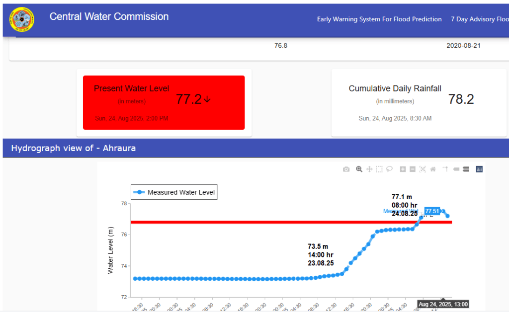
Uttar Pradesh: River Jirgo at Ahraura site in Mirzapur district has crossed its HFL 76.8 meter dated 21.08.2020 at 08:00 hour on 24.08.2025 and has attained a new peak of 77.51 meter at 13:00 hour on 24.08.2025. The new HFL is 0.71 meter higher than the old HFL for the site.


West Bengal: River Ichamati in Ganga basin has breached HFL at 3 sites Kuthibari, Bajitpur and Bangaon in North 24 Parganas district. This is 3rd time the river is breaching HFL at Kuthibari site and 2nd time at Bajitpur site in this monsoon season.
URBAN FLOOD
Concrete boom outpaces flood mitigation efforts, say experts Two trends are unfolding in the city today, and the gap between them is as wide as the Mithi river in full spate. On the one hand, the BMC is spending a lot of money on reducing the impact of flooding, from river rejuvenation and floodwater pumps to hazard mapping and private weather services. The agency’s analysis found that 38% of this year’s budget goes to climate-related action, mostly on flood and water management. On the other hand, authorities continue to push infrastructure and real estate projects that expand concrete cover and thus stormwater runoff, without adequate precautions. Redevelopment alone is adding around 344 million square feet of built-up area, estimates show.
Over 900 mm rains lashed Mumbai within a span of 5 days between August 15 and 19, in what left the streets inundated, railway tracks submerged and also triggering floods in low-lying areas along the Mithi River. In the aftermath, Abhijit Bangar, Additional Municipal Commissioner (Projects) of BMC, told Nayonika Bose about the reasons behind the flooding in the previous week, challenges before the BMC and how it plans to make Mumbai resilient to the rising threat of erratic weather events. The current situation with flooding in both Pune and Mumbai should be a call to action, but because these are regular occurrences every year, we accept them as inevitable now take them in our stride
Data suggests that Indian cities are not well-equipped to handle even moderate rainfall. However, this is not uniform across entire cities, as factors such as landscape and topography influence whether water accumulates or is absorbed. Though official IMD data on waterlogging thresholds is unavailable due to varying hyperlocal conditions within cities, news reports and studies reveal the rainfall levels that trigger urban flooding.
That our cities drown every monsoon has to do with climate change, which causes intense bursts of rainfall, along with poor urban planning, encroachment of water bodies and rampant construction. That the cities get submerged is no surprise, but how fast they do is. Gurugram is the worst on our Doobo-meter, getting submerged in just 50 mm of rainfall in 24 hours.
HIMALAYAN DISASTERS
Geological Fault line activation in Chenab Valley In one of its recent reports regarding Chenab Valley, citing several incidents of mudslides and land sinking, an independent research group, JK Policy Institute has observed that in the Himalayan arc, land subsidence may occur due to the reawakening of a geographic fault where the Indian Plate has slid underneath the Eurasian Plate, all along the Himalayas, in the form of slow sinking known as the ‘creep moment’. Doda had seen a few minor earthquakes along with the neighboring Chamba district of Himachal Pradesh. This may have triggered a shift in the fault line resulting in the development of deep cracks in the area.
Kishtwar cloudburst was a tragedy foretold Parineeta Dandekar, Associate coordinator of SANDRP told NDTV that the absence of risk assessment was a critical oversight. “Paddar, the remote valley where Chasoti is located, is no stranger to natural disasters. Bhut Nallah, a tributary of the Chenab River, has a history of flash floods and landslides, with deadly incidents in 2021 and 2023, and another in Ramban in April 2025 that claimed lives and displaced thousands. Despite this, no comprehensive risk assessment was conducted for the Machail Mata Yatra, even during the peak monsoon season when such events are more likely”, she said.
36 cloudbursts, 74 flashfloods in HP so far Himachal Pradesh’s tally of cloudbursts is this monsoon so far is 36 across six districts of Chamba, Kinnaur, Kullu, Lahaul-Spiti, Mandi and Shimla. Mandi had the highest, 16 cloudbursts so far. HP has also seen 74 flash-floods and 63 landslides so far. 17 people have died in cloudbursts and 18 in flash-floods and landslides.
Shops damaged in ‘cloudburst’ induced flashflood in Lag valley of Kullu district Himachal Pradesh on Aug 19 night. Flashflood and ‘cloudburst’ incidents reported from Barshouna village in Bhuntar tehsil and Dalhouji area in Chamba district on Aug 24.
WDs Intensifying Himalayan disasters Monsoon 2025 saw 14 western disturbances between June 1 and Aug 20 2025, far higher than usual for the season. Five of these extra-tropical storms in the middle to upper layers of the troposphere occurred in June, five in July and four in August (up to August 20). At least four of them were strong and persistent, lasting between five and seven days. The longest persisted for seven days, from June 12 to 18.
“There are probably more cyclonic systems coming from the west, but their origin may not be as far as the Mediterranean. This needs to be studied more carefully. I think they are being born over Pakistan or slightly further west, due to interactions between the westerlies north of the monsoon circulation and the northward flow from the Arabian Sea, which is now extending further north,” Prof Raghu Murtugudde of IIT-Bombay said.
Extra-tropical storms intensified rainfall and triggered flash floods in Himachal Pradesh and Uttarakhand. Scientists link the anomaly to Arctic and West Asian warming, shifting jet streams northwards. Conflating cyclonic systems with western disturbances in India, may be signalling complex new risks.
Flash flood reignites debate on development On August 5, Dharali, a village in Uttarkashi, Uttarakhand, was hit by a flash flood in the Himalayan stream Kheer Gad, leaving at least 68 people missing and one dead. Rapid construction over the past two decades, including settlements on debris-flow fans along the Kheer Gad, compounded flood impacts. The proposed widening of National Highway- 34 in a section of the Bhagirathi eco-sensitive zone along Dharali could lead to the felling of 6,000 deodar trees, raising concerns about landslide risk. (Kavita Upadhyay)
According to government reports, landslides and flash floods have flattened 245 villages in the state over the last decade, and 2,629 families have been permanently relocated. Over ₹11 crore has been spent on shifting and resettling 255 families in 2025-26 so far.
Understanding cloudbursts The cloudbursts in the Indian Himalayas are inevitable natural phenomena, but their impacts can be greatly reduced with a combination of science, infrastructure, community awareness, and governance. With climate change likely to make such events more intense, preparedness and resilience-building are not optional—they are essential for safeguarding lives, ecosystems, and livelihoods in this fragile mountain region.
A 2025 study reviewing cloudburst events from 1970 to 2024 found Uttarakhand most affected, with frequent incidents also recorded in Himachal Pradesh and Jammu and Kashmir. Flash floods during the monsoon season and winter weather systems have both contributed to rising damage.
Flash-floods in Chamoli-Uttarakhand on Aug 23 A cloudburst in Uttarakhand’s Chamoli district has triggered flash floods and landslides, leaving several houses washed away or damaged and vehicles washed away or buried under debris in the early hours of Aug 23. A 20-year-old woman, identified as Kavita, has been trapped under rubble, while another person, named Joshi, is missing. Rescue teams from the NDRF and SDRF have been deployed. Even SDM house suffered damage. Ten key roads have been damaged or blocked due to the flash floods Chamoli ADM Vivek Prakash said. A flood-like situation persists in Tunri (Or Toonari) Gadhera and the debris has reached structures near the Pindar River. Schools remained shut in three development blocks of Chamoli and across Pithoragrah dist at government’s order. Over 30 people were injured when trying to escape, six of them were in critical condition.
Tunri Gadhera also filled the tehsil office with debris before joining the Pindar River. According to the Chamoli District Disaster Management Centre, the Karnaprayag-Gwaldam National Highway connecting Tharali has been closed due to debris near Ming Gadhera.
Cloudburst hits Chamoli Rescue efforts are underway after a cloudburst struck Chamoli’s Tharali tehsil in Uttarakhand early Saturday morning, with debris entering several houses, officials said, adding that at least one person is missing and a girl is trapped under the rubble. The cloudburst around 2 am caused destruction across multiple locations within a kilometre radius of the tehsil headquarters, as water levels in local streams rose sharply, Chamoli district magistrate (DM) Sandeep Tiwari said. Flashflood also affected Sagwada and Chepdon areas in the Tharali tehsil.
Timeline, responsibility for managing highway disasters In light of increasing incidents of natural disaster like cloudbursts and floods badly impacting highways and disrupting normal life, the govt has notified a detailed Disaster Management Plan (DMP) for the road and highway sector, specifying timelines for quick inspection and preparation of rehabilitation plan, for officials in the field as well as at headquarters. Financial powers have also been delegated for execution of these tasks.
As per the DMP, the field officer or project head must swing into action within six hours of the occurrence of a disaster and monitor its impact on the national highway in question regularly, in close coordination with the district administration. They need to quickly inspect the site, assess the severity of damage and prepare a technical plan for restoration and repair. The official concerned will be delegated financial powers if the estimated cost of restoration or repair is within Rs 25 lakh per spot and within Rs 1 crore for all spots affected by the disaster.
POWER SECTOR
India is curbing Solar electricity generation during low demand India is curbing solar output during periods of low demand to keep its power grid stable and to ease congestion in power lines as green energy supply rises, its Ministry of New and Renewable Energy (MNRE) said. Congestion in power lines due to some new plants coming into operation ahead of schedule and delayed transmission projects have also forced power output curbs, also known as curtailment, the MNRE said on Aug 18.
The renewable power developers are increasingly languishing without supply contracts as demand for power slows. The National Solar Energy Federation of India (NSEFI) said in a July 24 letter to the ministry that solar power producers in Rajasthan, the top green power producing state, were facing prolonged and frequent curtailments, which had risen to 48% of output during peak generation hours. The producers have lost more than $26 million in revenue since April due to the curbs, NSEFI said. “Projects in the state had been deferred by 18-20 months to accommodate for the delays in the transmission system, but are still unable to be commissioned due to even further delays,” NSEFI said.
ENVIRONMENT GOVERNANCE
Karnataka 66 per cent industries operating sans consent: CAG The CAG report citing Subject Specific Compliance Audit (SSCA) on the functioning of Karnataka State Pollution Control Board (KSPCB), on Wednesday stated that 66 per cent of industries in Karnataka operated without valid Consent for Establishments (CFE) or Consent for Operations (CFO). Also, many continued operations even after approvals had expired. the CAG pointed to information gathered from the departments of Industries and Commerce, Forests and Railways, and cross-verified it with Karnataka State Pollution Control Board data, which revealed that of 2,756 industries, 1,827 (66%) had obtained consents; 66 industries and 22 railway stations/sheds/sidings were covered under the consent net.
SOUTH ASIA
China Dam on Yarlung Tsangpo Himanshu Thakkar, an engineer and coordinator of SANDRP said downstream countries like India and Bangladesh must publicly demand details of basic features of the dam and the standard operating procedures, including the exact dam location, storage capacity (both live and total), dam height from bed and the lowest foundation, and the location and configuration of the power projects. “It is the right of the downstream countries and their people to get this information and it is the duty of the upstream country to provide this. In fact downstream countries can even demand joint impact assessment,” Thakkar added.
But this (GOI response in Parliament on the subject recently) is a generic response that does not address questions about how exactly India is engaging with China and what information China has shared about the design and operation of the dam. Such information should be placed in the public domain and shared with local people in Arunachal Pradesh who stand to be directly affected by the dam, Thakkar said.
“Like how Arunachal Pradesh faces flood risks from the Chinese dam, Assam could face flood risks from a dam in Arunachal Pradesh. So, it is the same upper riparian-lower riparian dynamic playing out in India. Engineers will say this is the right approach because we need storage. But there are issues. And there are strong local voices in Arunachal Pradesh raising concerns about safety and resettlement. The other thing we should look at is more scientific flood mitigation efforts in the Northeast and understanding inland waterways to channelise river flows better,” (Uttam Kumar) Sinha (Sr Fellow at Mohan Parrikar Institute of Defence Studies and Analyses) explained.
India plans mega dam in Arunachal Pradesh, with eye on China’s hydro project in Tibet Mr Himanshu Thakkar, of the SANDRP, said that there is very little credible information in the public domain in India about the Medog Hydropower Station, something that is necessary for the country to formulate its appropriate response. “Until and unless you know the basic and salient features of the (Medog) project, you can’t even start speculating on its capacity to cause harm downstream, whether it is to create floods or dry up the river,” he said. Questions linger about the extent of the impact of the Chinese dam downstream in India. The Yarlung Tsangpo river, as it enters India, contributes only between 14 per cent and 15 per cent of the total flow of the Brahmaputra, with the rest made up of other sources downstream, including tributaries and monsoon rains.
Mr Thakkar suggested that India should publicly demand details of the Medog dam from Beijing, something China is obligated to provide under international law as an upper riparian state. “And India should use all its monitoring capacity to understand what China is up to so that we can decide whether we need this large dam in Upper Siang in the first place,” he added. But there are fears that the Upper Siang dam will be pushed through in the name of national security, despite widespread opposition and ecological concerns. “Pushing the dam through in a hurry as a strategic weapon or response would be a mistake,” Mr Thakkar said. “We will only end up creating a monster without fully understanding the impacts and implications of what we are doing.”
China fails to respond to Bangladesh request to share information about Yarlung Tsangpo dam Bangladesh’s request sent this year to China about sharing feasibility studies done on its massive dam failed to yield any result. Joint Rivers Commission member Mohammad Abul Hossen said that they requested China two years ago to share any studies conducted on the potential impacts of constructing the dam without receiving any response yet. The Bangladesh experts called on China and India for conducting a joint Strategic Environmental Assessment to determine the impacts of the proposed dams. They also urged Bangladesh to become proactive, taking initiatives such as signing the UN’s international watercourse convention and working together with India to diplomatically put pressure on China against its potential unilateral control of common river water.
Misleading report? This Reuters report, quoting all anonymous sources and undated document seems to have no bases. It claims: “the Chinese dam will allow Beijing to divert as much as 40 billion cubic meters of water, or just over a third of what is received annually… The Upper Siang project would alleviate that with its projected 14 BCM of storage capacity, allowing India to release water during the dry season. That could mean the major regional city of Guwahati, which is dependent on water-intensive industry and farming, would see a reduction in supply of 11%, according to the sources and the document, as opposed to 25% if the Indian dam isn’t built.”. However, this does not look plausible based on information so far available as the project is essentially hydropower project, so there won’t be any consumptive use of water. Secondly, Guwahati being dependent on water intensive industry that would be affected by the Chinese project is also not plausible even looking Assam Chief Minister statements.
Same is true of the claim in the Reuters report: “If the dam is at its minimum drawdown level – where water is stored at less than 50% of its height – it would be able to fully absorb any excess water released from a breach in Chinese infrastructure… India is considering a proposal to keep 30% of its dam empty at any time in order to account for unexpected surges”.
Indus Basin: India warns Pak about Tawi River Floods Indian High Commission in Islamabad has on Aug 24 morning contacted Pakistan under the Indus Waters Treaty (IWT) to share advance information about possible flooding due to Tawi River flowing from Jammu region.
Nepal: WB, ADB, EIB under fire for backing Tanahu, other HEPs Civil society leaders in Nepal continue to raise concerns about the under construction 140 MW Tanahu hydropower project (likely to be completed next year) in Gandaki province, citing a lack of proper consultation, inadequate compensation for displacement, and environmental impacts. Project developer Tanahu Hydropower Limited (THL), a subsidiary of the Nepal Electricity Authority, says it has completed the consultation process. Half of the complaints against hydropower projects in Nepal documented by a rights watchdog are related to the Tanahu project, which receives funding from the Asian Development Bank, European Investment Bank and World Bank.
Local communities and Indigenous peoples say the project was implemented without proper consultation and failed to respect their rights to land, territory, and free, prior and informed consent (FPIC). The complaints range from inadequate information disclosure, impact on sacred sites, environmental degradation, to forest loss and potential impacts on the flow and biodiversity in the Seti River.
Hurdles and opportunities for conservation of native fish biodiversity ABSTRACT: A steep north–south elevational gradient in Nepal supports a diverse freshwater fish fauna ranging from coldwater to tropical species. About 23% of the land area of Nepal is protected, but the conservation of water resources and aquatic species, which provides critical ecosystem services, has yet to be a primary goal. Threats to native fishes include habitat alteration, nonnative species, dams, unregulated exploitation, and climate change. Additionally, the fishes of Nepal are undersampled and inadequately known, with high levels of taxonomic uncertainty, potential cryptic species, and species that are likely unknown to science. Opportunities for effective conservation of native fish biodiversity are emerging, however, and center on the co-production of knowledge and co-development of conservation strategies with local communities. A multifaceted approach that integrates conservation with sustainable development is needed to protect Nepal’s unique ichthyofauna and to promote a sustainable future for aquatic resources that are crucial to Nepal’s ecology, economy, and culture.
SANDRP

Every year, during peak monsoon season, dams built in himalayan region are unable to cope up to hold the rise of water level. Hence, one after another dam flood gates are open, creating floods in lower regions. Still government nods for more dams in HP and Arunachal showing reasons that dams are going to save people downstream from getting flooded. Either they don’t remember what they said earlier or people forget. Sainj valley was flooded repeatedly since Parvati I and II came into being. People of Malana are now objecting against upcoming Malana dam. Similarly low lying areas in Punjab and Himachal have been flooded by Pong dam releases even last year too. Each time however, there’s one very conspicuous management that can be seen on indian media, “headline management.” Whether there are loss of lives and property, respective state governments are clueless about how to save local people from repeated disasters like this. Who’s going to tell them that CLIMATE CHANGE doesn’t happen on its own, it’s human activity induced phenomenon. Spending tax money for funding 4 to 6 lane highways, tunnels, rail network and building dams in the himalayas are the main human activities which by the way are not done by local people though some of them are enticed to say things in favour of political narrative endangering the life of all the inhabitants. If these so-called development works don’t stop, we will keep seeing more damages every time.
And what’s “war-footing” BTW when people of Dharali and Kishtwar don’t even get the correct information about their missing people!!
LikeLike
Many thanks, very apt comments. Do keep posting such useful comments and sharing the links you find useful from this blog.
LikeLike