(Feature Image: 2019 image of Bhakra dam. Source: Punjab Kesari)
One aspect that stands out not so obviously in the ongoing water dispute between Punjab and Haryana is the poor track record of BBMB in achieving operational safety of BBMB projects during floods, particularly in recent years, but also starting from way back in 1970s. That is why it sounds strange when in early May, BBMB is talking about need for water releases to safeguard the Bhakra dam’s structural integrity, when the dam is at its lowest level in the season. We see no such urgency or public statements by BBMB during the monsoons last few years when not only IMD had forecast heavy rainfall in the catchment, but also there was no action by BBMB even when catchments had already received heavy rainfall.
The BBMB also publicly cited the need to follow the technical requirements based on rule curve while advocating water release for Haryana. This is also strange in early May when dam is at the lowest level as BBMB showed no such concern of following the rule curve or making public statements about need to follow rule curve several times during monsoon in last few years, leading to avoidable flood disaster in Punjab more than once. In fact, as we and others advocated, this should have led to independent inquiry and making the responsible BBMB official accountable. Nothing like that happened. In fact, the rule curves of the Bhakra dams are not even in public domain, which must be.
It is high time that BBMB show the urgency of safe operation of the Bhakra dams all throughout the year, take necessary steps, institute independent inquiry and make the responsible persons accountable. That alone will bring better credibility to BBMB’s public statements in this regard.
BBMB Water release needed to safeguard Bhakr’s structural integrity: Experts Very interesting Technical experts (wonder who are these technical experts who are talking about water releases for safety in the first week of May, but remain quite in the monsoon when the dam are near full) from the Bhakra Beas Management Board (BBMB) had asserted that the release is necessary to lower reservoir levels and safeguard the dam’s structural integrity, particularly in light of Indian Meteorological Department (IMD) forecasts predicting substantial monsoon inflows.
– Even in the April 23 TCM of BBMB, the board’s chairman informed that “as per the technical requirement based on the rule curve, the reservoir level has to be brought down” (what about following the rule curve during monsoon when dam is near full long before the end of monsoon) and there should not be any objection from partner states in this regard. The manual of Nangal Dam and Nangal Hydel Channel stipulates that releases from Bhakra dam/Nangal dam shall be made by the senior design engineer/water regulation in line with the decision taken by the TCM.
– The BBMB informed in the meeting that with the present inflow pattern, the levels of Bhakra as of May 20, which is the end of the depletion period, will be between 1,540-1,545 feet, which will be higher than the long-term average levels of Bhakra on that date and will also be higher than the minimum level decided by TCM, which is 1,506 feet. BBMB also informed that the minimum draw-down level for Bhakra is 1,462 feet.
– The operation of reservoirs is classified in two distinct periods: filling period and depletion period. The filling period is traditionally taken from May 21 to Sep 20 in case of Bhakra reservoir and Jun 21 to Sept 20 in case of Pong reservoir. The depletion period is from Sep 21 to May 20 next year in case of Bhakra and up to June 20 next year in case of Pong.
– During the filling period, deliveries to states are given as per requirements projected/decided in the technical committee meeting (held every month), considering the level and the inflows.
– During monsoon seasons when levels are high and inflow is more, emergent TCM meetings are held to review the flood situation/releases to be made from reservoirs. During depletion period, states are intimated their share out of Ravi, Beas and Satluj waters by taking starting level of Bhakra and Pong reservoirs as on Sep 21 and level ending May 20 as 1,506 feet in case of Bhakra and 1,301 fe et in case of Pong to cater the minimum requirements in case monsoon is delayed. https://timesofindia.indiatimes.com/city/chandigarh/punjab-haryana-dispute-water-release-needed-to-safeguard-bhakra-dams-structural-integrity-may-create-unpleasant-situations-during-monsoon-said-technical-experts/articleshowprint/120941908.cms (07 May 2025)
Dam Safety Act must be annulled: Resolution The resolution, moved by the AAP government during a special session of the assembly, on Monday sought immediate annulment of Dam Safety Act-2021, calling it a direct attack on Punjab’s rights. Punjab water resources minister Barinder Kumar Goyal, who moved the resolution, said: “The BJP has been trying to take away the rights of Punjab through its governments in Haryana and at the Centre, and the BBMB.”
– “This law fully empowers the central government to directly control the rivers and dams of the states, even if the dam is entirely within the state’s borders. This is against India’s federal structure and undermines the sovereign right of states such as Punjab over their water. Therefore, this House demands from the central government that the Act be repealed immediately, and Government of Punjab rejects it completely,” Goyal said while reading out the resolution. Mann, while speaking in the House, also outrightly rejected the Dam Safety Act. “Punjab can protect its dams on its own. It doesn’t need anyone else,” he said.
– The resolution also sought reorganisation of the BBMB. “At present, the BBMB has become a mere puppet of the BJP government at the Centre. In the meetings of the BBMB, Punjab is neither being heard nor are the rights of Punjabis being taken care of. So, the BBMB should be reorganised to protect the rights of Punjab,” it said. https://www.hindustantimes.com/cities/chandigarh-news/dam-safety-act-attack-on-punjab-s-rights-must-be-annulled-resolution-101746473456391.html (06 May 2025)
Will soon have own dam safety Act: Punjab CM Bhagwant Mann on May 5 told the state Assembly that his government would soon draft a state dam safety Bill. The statement came after the House unanimously termed the central Dam Safety Act, 2021, an attack on the rights of the state. https://www.tribuneindia.com/news/punjab/will-soon-have-own-dam-safety-act-cm/ (06 May 2025)
Punjab CM calls BBMB ‘useless’ The CM said this after Cabinet minister Barinder Kumar Goyal moved a resolution against the BBMB order allocating additional water from the Bhakra Dam to Haryana. The CM said both rivers belonged to Punjab as these flowed through the state, making these entirely the “rightful property of Punjab”. Mann said Haryana and Rajasthan had no direct connection with these rivers. However, the CM said Punjab’s waters had been diverted to other states by the BBMB for years. The CM alleged that meetings were being called by the board “at midnight” without consulting Punjab and under pressure from other states. https://www.tribuneindia.com/news/haryana/mann-calls-bbmb-useless-says-wont-accept-its-orders/ (06 May 2025)
‘Punjab won’t give single drop of water to Haryana’: Resolution Punjab’s Water Resources Minister Barinder Kumar Goyal moved the resolution during the special session of the state assembly, and it was taken up for discussion in the House. Goyal, while reading out the resolution, said the BJP has been trying to take away the rights of Punjab through its governments in Haryana and at the Centre, and the BBMB. This House strongly condemns the “illegal and unconstitutional” convening of the BBMB meeting by the BJP, said the resolution. The House also considers the Dam Safety Act 2021 to be an attack on the rights of Punjab, it said. Participating in the discussion, Leader of Opposition Partap Singh Bajwa extended full support to the resolution, asserting that there is not even a single drop to spare. https://www.deccanherald.com/india/punjab/punjab-wont-give-single-drop-of-water-to-haryana-resolution-moved-in-punjab-assembly-3524950 (05 May 2025)
Contempt case made out against Punjab over water row: HC The High Court here on Friday (May 09) said prima facie a case of contempt was made out against Punjab as the state did not comply with the order directing it not to interfere in the working of the BBMB. A Division Bench of Chief Justice Sheel Nagu and Justice Sumeet Goel said a notice would be issued to the Punjab Chief Secretary and the Director General of Police in this regard.
-The Bench, at the same time, made it clear that it would hold its hand till Monday (May 12) if Punjab assured compliance with the order. A detailed order in this regard was yet to be issued. Hearing the matter, the Bench asserted that judicial directions, whether right or wrong, were binding until stayed or set aside. https://www.tribuneindia.com/news/punjab/contempt-case-made-out-against-punjab-over-water-row-hc/ (10 May 2025) “Prima facie, it is a case of violation of our orders. Let Punjab file a reply. If you do not permit the BBMB chairman to visit his installation, how will he manage day-to-day affairs of the board?” observed Chief Justice Sheel Nagu, part of a two-judge division bench. https://timesofindia.indiatimes.com/india/punjab-chief-secretary-dgp-face-contempt-for-defying-hc-order-on-water-row/articleshow/121042224.cms (10 May 2025)
HC orders Centre to reveal May 2 meeting details The Punjab and Haryana high court on Thursday (May 08) directed the central govt to produce the details of the May 2 meeting held under the chairmanship of the Union home secretary in which it was decided to release 4,500 cusecs of extra water by the Bhakra BBMB to Haryana for the next eight days to meet its urgent water requirement.
-The HC also directed the Centre to inform about the authority that could be approached by the partner state in case of any dissent over the decision taken by the BBMB. A division bench, comprising Chief Justice Sheel Nagu and Justice Sumeet Goel, also directed BBMB chairman Manoj Tripathi to submit an affidavit explaining how his two officials — Sanjeev Kumar, director, water regulation, and Rajesh Vashisth, deputy secretary, — were restrained by the Punjab Police from operating at the Bhakra Dam on Thursday (May 08) morning.
-On the contention of Additional Solicitor General of India Satya Pal Jain that minutes of the May 2 meeting were not recorded and a press release was issued, the HC observed that the Centre may mention that in its reply. The matter would come up for hearing on Friday (May 09) at 2 pm. https://timesofindia.indiatimes.com/city/chandigarh/water-dispute-hc-orders-centre-to-reveal-may-2-meeting-details-seeks-clarity-on-dispute-redressal/articleshowprint/121007647.cms (09 May 2025)
BBMB’s attempt to release more water to Haryana thwarted Tensions between Punjab and Haryana over the release of additional water to the latter from the Nangal dam escalated again on Thursday (May 08) when BBMB Chairman Manoj Tripathi reached the Lohand control room in the morning and released 200 cusec water.
-The Punjab Govt had reportedly not given its consent or placed an indent for the release of additional water. Swinging into action, state officials immediately stopped the flow of water to the neighbouring state. By the time Tripathi reached Nangal, protesters and cops were already there and he could not reach the water regulation office there. https://www.tribuneindia.com/news/delhi/bbmbs-attempt-to-release-more-water-to-haryana-thwarted/ (09 May 2025)
HC restrains Punjab from interfering in BBMB functioning The Bench said Punjab ought to have represented before the Central Government. But it did not make any such representation. The court also made it clear that Punjab was “always free to extend security” to the Bhakra Nangal Dam and BBMB personnel, but it could not interfere in the day-to-day functioning of the BBMB “so as to obstruct the operation and management of the Bhakra Dam and water-related works”. https://www.tribuneindia.com/news/punjab/high-court-restrains-state-from-interfering-in-bbmb-functioning/ (08 May 2025) https://www.livelaw.in/high-court/punjab-and-haryana-high-court/punjab-haryana-high-court-punjab-police-cannot-interfere-with-operation-of-bhakra-dam-291488 (07 May 2025) Punjab Police Obstructed Release Of Dam Water To Haryana Despite Court Order: BBMB Chief Claims In High Court. https://www.livelaw.in/high-court/punjab-and-haryana-high-court/punjab-haryana-water-dispute-bhakra-nangal-dam-punjab-police-bbmb-291653 (08 May 2025)
Punjab minister locks BBMB chairman at Nangal dam High drama prevailed at Nangal dam in Rupnagar district on Thursday (May 08) when Punjab AAP minister Harjot Singh Bains brazenly locked BBMB chairman Manoj Tripathi for two hours at the dam’s guest house despite the high court directive to the AAP govt not to interfere in the working of the BBMB. CM Bhagwant Mann also rushed to the dam and declared BBMB officials would not be allowed to release water to Haryana.
-A division bench, comprising chief justice Sheel Nagu and justice Sumeet Goel expressed serious concern over the alleged conduct of the Punjab administration, comparing the situation to actions taken against hostile countries. “We are doing this to our enemy country. Let us not do this within our states,” it remarked during the hearing. https://www.hindustantimes.com/cities/chandigarh-news/punjab-minister-locks-bbmb-chairman-at-nangal-dam-cm-backs-brazen-act-101746696129639.html (08 May 2025)
We are doing this to Pak; let us not do this to our States: HC The Punjab and Haryana High Court on Tuesday (May 06) took exception to the ongoing water dispute between the States of Punjab and Haryana, saying that while India has decide to take measures against Pakistan, the States within the country should not be doing the same against each other. https://www.barandbench.com/news/punjab-haryana-high-court-water-dispute-enemy-state-nangal-dam (06 May 2025)
BBMB moves HC against Punjab’s dam takeover The BBMB on Monday (May 05) moved the High Court here, seeking the removal of Punjab Police personnel from the Nangal Dam. The board contended that the state government “took control of the dam illegally” following a tussle over river water sharing with Haryana. The board averred that the government action was “unconstitutional and illegal”, and it infringed on the BBMB’s statutory authority under the Punjab Reorganisation Act, 1966.
-The BBMB has contended that Punjab cannot resort to any illegal, forcible or arm-twisting action, which is against the very spirit of statutory provisions. It said in case of any disagreement with any partner state, the matter could only be taken up with the Centre, which is the final arbiter in accordance with the rules. In case, such action of any particular state is allowed to prevail, the same would lead to an anarchic situation where any and every state could enforce its own decision through the use of force, the BBMB said. https://www.tribuneindia.com/news/punjab/bbmb-moves-hc-against-punjabs-dam-takeover/ (06 May 2025)
Police deployment linked to India-Pak tension: Punjab The AAP govt in Punjab, which had on May 1 stationed a large police force under a DIG-rank official to take control of the Nangal Dam and its control room amid the water release impasse with Haryana, on Monday (May 05), explained it as a safeguard due to heightened India-Pakistan tensions following the Pahalgam terror incident.
Information regarding Punjab’s latest stand on the deployment of security was provided to the Punjab and Haryana high court by the counsel representing the BBMB. The board’s counsel placed on record an email before the bench in which Punjab clarified that the security was deployed in view of tension with the neighbouring country. However, the counsel told the HC that BBMB had got no such advice from the Centre. https://timesofindia.indiatimes.com/city/chandigarh/punjab-govt-says-nangal-dam-police-deployment-linked-to-india-pak-tension/articleshow/120910079.cms (06 May 2025)
Opinion Cooperation is needed before the wells run dry Can Punjab and Haryana transform this conflict into an opportunity for resilience? The dispute highlights not only a fight over water but also a fundamental failure of sustainable resource management. A joint task force, crop diversification, groundwater recharge, and compromise on SYL could ensure equitable water sharing and sustainability. The challenge is whether political will and collective action can triumph over division, setting a precedent for India’s water-scarce future. Both states must act before the wells run dry. (Neeraj Singh Manhas) https://indianexpress.com/article/opinion/columns/punjab-haryana-water-crisis-cooperation-is-needed-before-the-wells-run-dry-9992831/ (09 May 2025)
HYDRO POWER PROJECTS
Rajasthan Concerns over Shahbad PSP Shahbad forest in Baran district is vital to the lives of tribal families like his, is now under threat as 408 hectares of it are proposed to be diverted for 1,800-Mw pumped storage project being built by Greenko Energies Private Limited. More than 1.19 lakh trees are to be felled. The Moondiyar villagers recently called a meeting to oppose the project. Losing the forest means losing food, income and identity.
In Shahbad, the forest is not just land. It shields the villages from punishing heat, nourishes groundwater and provides food, shade and grazing land for both people and wildlife. The Shahbad forest is also home to many endangered species listed in Schedule 1 of the Wildlife Protection Act, including leopards, sloth bears, striped hyenas, vultures, wolves, jackals, porcupines and pythons. Even the EIA report says the project will fragment the landscape, disturb biodiversity & likely increase conflict between animals and humans. https://theprint.in/india/clean-energy-costly-future-rajasthans-forest-communities-fight-to-save-ancestral-land/2622488/ (11 May 2025)
Report Framework to guide renewable energy sector As the renewable energy (RE) industry doubles down on deployment, it is imperative that stakeholders adopt a responsible approach to how we produce, deploy, consume, and value RE, one that is ecologically positive and people-centric. While the sector increasingly recognises the importance of responsibility, it often lacks a clear, shared framework to guide how to implement it in practice. Without standard benchmarks and protocols, efforts remain fragmented, limiting the potential for a responsible RE transition.
-It is to address this lacuna that the Responsible Energy Initiative (REI), of which the Council on Energy, Environment and Water (CEEW) is a part, has developed a framework for responsible RE deployment, titled ‘How Can India Enable a People-centric Clean Energy Transition?’ In this interview, Akanksha Tyagi, Programme Lead at CEEW and one of the framework’s chief authors, speaks with Joeanna Rebello Fernandes about its key features and how both new and ongoing RE projects can put its principles into practice. https://idronline.org/article/climate-emergency/a-framework-to-guide-indias-renewable-energy-sector/ (06 May 2025)
Kerala Indeed KSEB’s misguided push for more hydro in Kerala is questionable on many counts. https://www.thehindu.com/opinion/op-ed/ksebs-hydel-push-stirs-fresh-concerns/article69545552.ece (07 May 2025)
Uttarakhand जमरानी बांध की ब्लास्टिंग से घरों में आई दरारें नैनीताल जिले के भीमताल ब्लॉक में पनिया मेहता तोक के खत्री खाड़ गांव में इन दिनों लोग दहशत में हैं. खत्री खाड़ गांव के कई घरों में दरारें पड़ चुकी हैं. खेतों में दरारें आई हैं. दरारें पड़ने का कारण इलाके में जमरानी बांध परियोजना के लिए हो रही ब्लास्टिंग को बताया जा रहा है. जिला प्रशासन की टीम ने भी गांव में पहुंचकर दरारों का निरीक्षण किया. इस संबंध में परियोजना प्रबंधक जमरानी बांध निर्माण में लगी कंपनी को निर्देश दिये हैं कि सिस्मोग्राफ स्थापित होने तक क्षेत्र में ब्लास्टिंग न की जाए. इस दौरान गांव में टीम द्वारा सुरक्षा दीवार का भी निर्माण करने की बात करते हुए परियोजना प्रबन्धक को निर्देश दिये.
-गौरतलब हैं बांध निर्माण का काम शुरू होने के बाद एकाएक आई दरारें अब चौड़ी हो रही हैं. ग्रामीणों का आरोप है कि जमरानी बांध टनल आदि कामों में ब्लास्टिंग और सड़क कटिंग की जा रही है, इसके बाद से ही मकानों में दरारें आनी शुरू हुई हैं. ब्लास्टिंग बढ़ने के साथ ही दरारें भी चौड़ी हो रही हैं. ग्रामीण भुवन पडलिया ने बताया कि क्षेत्र में हो रही ब्लास्टिंग से मकानों में दरारें आई हैं. इससे ग्रामीण परेशान हैं. प्रशासन से सुरक्षा की दृष्टि से जांच कर पीड़ित परिवार को आर्थिक सहायता दिलाने की मांग की गई है. https://www.etvbharat.com/hi/!state/cracks-appeared-in-houses-due-to-blasting-of-jamrani-dam-project-in-khatri-khad-village-of-bhimtal-block-nainital-uttarakhand-news-uts25050102159 (01 May 2025)
Arunachal Pradesh Possibility of constructing mini HEP on Peneng Pasighat West MLA Ninong Ering is exploring the possibility of constructing a 2 Mw mini-hydel on the Peneng River in his constituency. The MLA, who is also the adviser to the state government for hydropower, is envisioning utilising the water for various purposes, including irrigation, freshwater fishery, and construction of swimming pool projects. Additionally, mini-bundhs along the river could help control flooding and soil erosion during the rainy season, he said. Recently, Ering held a meeting with the sub-divisional administration and engineering department heads at Ruksin, and directed the hydropower engineers to conduct baseline surveys along the Peneng River from Ledum to Ruksin and submit a report within this year. https://arunachaltimes.in/index.php/2025/05/11/ering-exploring-possibility-of-constructing-mini-hydel-on-peneng-river/ (11 May 2025)
Himachal Pradesh Larji Dam to release water In light of increasing water levels in the Beas river and its tributaries, the authorities at Larji Hydro Electric Project (HEP) Kullu, which has an installed capacity of 126 MW, have announced the controlled release of approximately 50 cubic meters per second (cumecs) of water from Larji Dam. https://www.tribuneindia.com/news/himachal/public-advisory-issued-in-mandi-as-larji-dam-to-release-water-amid-rising-beas-river-levels/ (09 May 2025)
Madhya Pradesh Water released from Gandhi Sagar dam for power project Release of water from Gandhi Sagar dam for construction of a 1920 megawatt Pumped Storage Project started on Friday after govt granted permission to draw 891.944 million cubic metre of water from it. The approval came under stipulated conditions provided in the no objection certificate and recommendations issued by Jaipur water resources department chief engineer. With this, water was released from the dam and will continue until May 14. On Friday morning, the dam’s water level was around 1295 feet and will be reduced to about 1288 feet in the next five days, senior officials said. https://timesofindia.indiatimes.com/city/indore/water-released-from-gandhi-sagar-dam-for-power-project/articleshowprint/121040960.cms (10 May 2025)
Uttar Pradesh JSW Energy lands 1.5-GW PSP deal JSW Neo Energy Ltd has signed a deal with electric utility UP Power Corporation Ltd to supply 1,500 Mw/12,000 MWh of pumped hydro energy storage capacity. The pumped hydro storage power procurement agreement (PHSPPA) will be in force for 40 years, JSW Energy said in a bourse filing on Thursday (May 01). The subsidiary of the company will receive a fixed capacity charge of INR 7.72 million (USD 91,620/EUR 80,774) per MW per year.
The contracted capacity will come from a pumped hydro storage project at Sonbhadra district. The facility will be capable of a scheduled discharge of 8 hours, of which up to 6 hours continuously, on a daily basis. JSW Energy expects to bring the site online over the next 6 years. With the latest contract, JSW Energy’s total locked-in energy storage capacity stands at 28.3 GWh, including 26.4 GWh of pumped storage. Its goal is to have 40 GWh of energy storage assets by 2030. https://renewablesnow.com/news/jsw-energy-lands-1-5-gw-pumped-hydro-storage-deal-in-uttar-pradesh-1274699/ (05 May 2025)
Industry Spot power prices down 50% in May Indian spot electricity prices fell up to 50% during May 1-5, 2025, due to unseasonal rains reducing demand and increased sell bids on the Indian Energy Exchange (IEX). According to the data by IEX, electricity consumption during May 1-May 5 stood at 23.5 billion units, a reduction of 6% from the same period last year. https://www.financialexpress.com/policy/economy/spot-power-prices-down-50-in-may-as-demand-reduces/3834929/ (07 May 2025)
MoEF Decisions of EAC meeting for River Valley Projects held on Apr 30, 2025: 1. Bhavali Pumped Storage Project (1500 MW) in 278.92 Ha in Village Kalbhonde, Kothale and Jamunde Sub Dist Shahapur and Igatpuri, Dist Thane and Nashik, Mah by JSW Energy PSP Two Ltd – Environmental Clearance: More Info Sought
2. Expansion of Tembhu Lift Irrigation Project in 2284.601 ha at Village Tembhu, Ranad, Govare and etc, Sub District Khatav, Atpadi, Karad and etc, District Satara, Sangli and Solapur, Mah– Environmental Clearance: More Info sought.
3. Extension, Renovation & Modernization (ERM) of Kamla Irrigation Project (CCA: 23,419.08 ha + 4,965.05 ha) in 26.7 Ha (additional) at Sub District Jainagar, Basopatti, Khajauli etc, District Madhubani, Bihar by M/s Water Resources Department, Govt of Bihar– Terms of Reference: More Info Sought. https://parivesh.nic.in/utildoc/126330728_1746513028461.pdf https://parivesh.nic.in/utildoc/126330728_1746513028461.pdf (May 2025)
Agenda of EAC meeting on River Valley Projects to be held on May 14, 2025: 1. Greenko Assam – 01 Closed Loop Pumped Storage Project (900 MW) in 251.94 Ha in Village Amguri, Baithalangso, Kiling Bagicha, Nali Bagicha No. and Sardangang, Sub Dist Marigaon and Donka, Dist Morigaon and West Karbi Anglong, Assam by Greenko Energies Private Limited – Terms of Reference
2. Guruvarya Late Laxmanraoji Inamdar Lift Irrigation Scheme (Jihe Kathapur), Phase I & II (CCA: 60437 Ha) in 173.614 Ha in Sub dist Man, Koregaon, Khatav and Satara, Dist Satara, Maharashtra by Ex Engr Jihe Kathapur Li Division Satara – Terms of Reference
3. Kalu Patti Pumped Storage Project (600 MW) in an area of 267 Ha in Village Devhat, Mudel, Lain, etc, Sub Dist Lalganj, Dist Mirzapur, Uttar Pradesh by Renew Hydro Power Pvt Ltd – Terms of Reference
4. Damanganga (Ekdare) – Godavari intrastate link project (CCA: 12998 Ha ) in 257.85 Ha at Village Ekdare, Gonde, Shinde, etc., Sub Dist Peth and Dindori, Dist Nashik, Mah – Amendment in Terms of Reference https://parivesh.nic.in/utildoc/126357768_1746525156243.pdf (May 2025)
DAMS
Polavaram Project International experts visit A four-member panel of international experts visited the Polavaram project on May 5. The team inspected the works for the buttress dam, diaphragm wall and Gap-1 and the quality control lab. They laid more stress on quality aspects on upcoming D-wall and on test reports. The panel would focus more on finalising the designs especially for the Gap-1 and would take a decision for making designs for Gap-2. They held a review meeting with officials from the water resources department and representatives from the contact agencies. The experts include-Richard Donnelly, Sean Hiinchberger, Gianfranco Di Cicco and David B Paul. They would continue inspection of various components of the project and suggest designs to be drawn till May 8. https://www.deccanchronicle.com/southern-states/andhra-pradesh/international-experts-visit-polavaram-project-1877143 (06 May 2025)
Kaleshwaram Project Telangana seeks CWC help to restore Medigadda barrage The Telangana government has sought the Central Water Commission’s (CWC) assistance to address severe structural issues in the Medigadda barrage, following damning findings by the National Dam Safety Authority. Telangana Irrigation Minister N Uttam Kumar Reddy met newly appointed CWC Chairman Atul Jain on Wednesday, 7 May. The Minister requested the CWC to carry out a comprehensive geotechnical and structural review and advise on the restoration and safety of the project. https://thesouthfirst.com/telangana/telangana-seeks-central-water-commission-help-to-restore-collapsed-medigadda-barrage/ (08 May 2025)
Mullaperiyar Dam Specialised experts needed to resolve issue: SC Interesting observation by the Supreme Court on Mullaperiyar project. CMs of Kerala and TN and PM may be respected persons, but in this field they may not have in-depth knowledge. “The CMs of Tamil Nadu and Kerala and our Prime Minister may be very respected persons. But in this particular field, they may not have the in-depth knowledge. That is why we wanted experts… Our interest is the safety and security of the dams,” Justice Dipankar Datta, a member of the three-judge Bench headed by Justice Surya Kant, remarked. https://www.thehindu.com/news/national/specialised-experts-and-not-politicians-are-needed-to-resolve-mullaperiyar-dam-issue-sc/article69546213.ece; https://www.livelaw.in/top-stories/supreme-court-directs-states-of-kerala-tamil-nadu-to-implement-supervisory-committee-recommendations-mullaperiyar-dam-291442 (06 May 2025)
Sardar Sarovar Project Bridge for affected tribals unbuilt Savaryadigar, shadowed by the Sardar Sarovar dam’s backwaters, was among 33 villages displaced in the early 2000s. While some were relocated, others like Savaryadigar were promised roads and a bridge instead. That call was made in 2005 by a govt panel led by then director general of Water and Land Management Institute, Satish Bhingare. He regrets the decision now. “We thought a bridge would take a year. It’s been 20,” he said.
Approved in 2012, work began a few years later and then stopped. Villagers are tired of hollow promises. The situation worsens during monsoon. Come June, the Udai river swells and cuts off villages. The rudimentary boat service turns risky, and ASHA workers ferrying pregnant women fear the worst. “I’ve had nightmares of losing patients,” said one worker from Bilgaon. The state tribal development department recently sanctioned Rs 45 crore for the Savaryadigar bridge. https://timesofindia.indiatimes.com/city/pune/promised-bridge-20-years-ago-tribals-still-stranded-with-only-three-pillars-in-maharashtras-udai-river/articleshowprint/120891817.cms (5 May 2025)
Gujarat Farmers in Gujarat are angry about the meager compensation offered to them for their land taken for Bhadbhut barrage on Narmada river in Gujarat. https://www.facebook.com/share/p/17rfkBaAM9/ (07 May 2025)

Maharashtra Patel Engineering Bags Rs 13.19 Bn Dam Project from CIDCO Patel Engineering has secured a contract worth Rs 13.19 Bn for the construction of the Kondhane Dam and its associated works from the City and Industrial Development Corp (CIDCO). The project, located in Kondhane village, Karjat Taluka, Raigad district in Maharashtra, is scheduled to be completed within 42 months. Patel Engineering had previously been declared the lowest bidder (L1) for this project. The contract includes civil works for a 1,209-m long and 83-m high dam, hydro-mechanical and electrical components, and the installation of three radial gates. It will also cover electrical and manual gate control systems and overall site electrification. The project will use Roller Compacted Concrete Technology. https://www.constructionworld.in/energy-infrastructure/power-and-renewable-energy/patel-engineering-bags-rs-13.19-bn-dam-project-from-cidco/73360 (09 May 2025)
Tamil Nadu WRD initiates measures for desilting Amaravathy Dam after a gap of decades The WRD is learnt to have drawn up an estimate of minimum expenditure on overheads for arriving at the ‘revenue model’ through selling the sediment in the Amaravathy Dam, in order to scale up the storage limit. The expenditure would be towards constructing the road till the location in the dam from where the sediment with high fertility value could be removed. Since the dam is located in the reserve forest area, the demand for the nutrient-rich sediment formed by the foliage washed down by jungle streams for decades will be quite high, according to officials.
The Water and Power Consultancy Services Ltd has prepared a report based on which the dept will be readying a Detailed Project Report through a consultant, a senior official of WRD said.An analysis by the department during 2017 indicated that the water spread area had 22.8 million cubic metre of silt. The Tiruppur district administration had then notified removal of 1,31,400 cubic metre of silt in the first phase. The current storage capacity of the dam is 4.047 tmc.
The initiative to desilt the dam was taken in 2014, but had to be shelved due to intervention by the NGT. The contention of the department was that new approval would not be necessary as desilting of the dam could be categorised under maintenance work and not any new project. But, it was not accepted by the NGT. The consultancy appointed now for preparing the DPR has been entrusted with the responsibility of securing environmental approval, official sources added. https://www.thehindu.com/news/cities/Coimbatore/water-resources-department-initiates-measures-for-desilting-amaravathy-dam-after-a-gap-of-decades/article69557301.ece (9 May 2025)
Karnataka High Alert at KRS dam Security at Krishanaraja Sagar dam in Srirangapatna taluk of Mandya taluk has been tightened further, following Indian Army’s strike at terrorist bases in Pakistan. The Karnataka State Industrial Security Force (KSISF) is closely monitoring people moving through the dam’s southern gate, Brindavan entrance gate and also those entering the Orchid Hotel. They are all being screened by the KSISF. High alert is in place near the KRS dam and where there is movement of people. The police are on duty 24×7, said KSISF Assistant Commandant Pramod. https://www.deccanherald.com/india/karnataka/high-alert-at-krs-dam-ksisf-deployed-near-all-dams-in-cauvery-basin-3532025 (08 May 2025)
Kerala Following a central government alert, a security warning has been issued for dams across the state. Police deployment has been increased at all dams to enhance security. This includes both power generation and irrigation dams. https://english.mathrubhumi.com/news/kerala/central-government-issues-alert-security-measures-beefed-up-across-dams-in-kerala-hbtj3gmn (06 May 2025)
Odisha Tight Vigil at Hirakud Dam In a significant security move, authorities have intensified surveillance at the Hirakud Dam in Sambalpur and prohibited tourist entry into the premises until further notice. The decision, taken as a preventive measure, comes amid growing concerns over the safety of critical national infrastructure. Local residents, meanwhile, have urged authorities to consider deploying air defence systems and other advanced protective measures at the site. Authorities have assured the public that the restriction is temporary and will be reviewed based on periodic assessments of the security situation. https://www.deccanchronicle.com/nation/tight-vigil-at-hirakud-dam-in-odisha-tourist-entry-prohibited-1877906 (09 May 2025)
Telangana ACB arrests Irrigation executive engineer for accepting bribe The Anti-Corruption Bureau arrested Irrigation Executive Engineer Amarender Reddy on charges of accepting bribes from a contractor. According to the ACB, Amarender Reddy, who is working as EE of Irrigation division-7 in Rajanna-Sircilla district, demanded Rs 1 lakh from a contractor to clear bills of Rs 50 lakh and accepted to take Rs 75,000. The contractor, who constructed a check dam in between Avunur-Agraharam village by spending Rs 8 crore, had already paid Rs 4 lakh bribe to the EE to clear bills of Rs 5 crore. https://telanganatoday.com/acb-arrests-irrigation-executive-engineer-for-accepting-bribe-from-contractor (10 May 2025)
INTERLINKING OF RIVERS
Ken Betwa Link Adivasis set to lose homes Himanshu Thakkar of SANDRP said that there are a large number of issues with the Ken-Betwa project. “One major issue is, of course, the question of justification of the project,” said Thakkar, who has previously appealed at the National Green Tribunal against the environmental impact assessment of the project. He said there may also not be sufficient water for a dam, as hydrological figures were never published or independently scrutinised. “So essentially, we are told to assume that there is surplus water in Ken without any figures,” he said. Thakkar listed the major lapses in conducting the environmental impact assessment. “It is one of the shoddiest I have ever seen,” he said, “and it is most inaccurate. In fact, it is a cut and paste job very clearly and it does not even mention what are the kind of impacts it will have on Panna Tiger Reserve.” He said the impact assessment report mentioned species that only exist in Manipur, suggesting that the report had lifted portions of the EIA conducted for the Paimon Dam in Manipur. https://article-14.com/post/as-modi-govt-fast-tracks-controversial-project-to-link-rivers-thousands-of-anxious-angry-adivasis-set-to-lose-homes–681a8524398a9 (7 May 2025)
A misguided megaproject A critical examination of the KBLP’s feasibility came during a Wednesdays.for.Water session organized by the WforW Foundation; a think tank dedicated to water conservation dialogues. The session, titled “The Decision-Making Process of the Ken-Betwa Link Project,” featured two experts who laid bare the project’s shortcomings. Himanshu Thakkar, an engineer from IIT Mumbai and coordinator of the SANDRP, questioned the core claim that the Ken River has surplus water. https://www.counterview.in/2025/05/the-ken-betwa-link-project-misguided.html (07 May 2025)
INTERSTATE WATER DISPUTES
SYL Dispute SC directs Punjab, HR to cooperate with Centre A bench of Justices B R Gavai and Augustine George Masih was informed by the Centre that it has already taken effective steps to resolve the issue amicably. “We direct both the states to cooperate with the Union of India in arriving at an amicable solution,” the bench said. The bench said it would hear the matter on August 13 if it is not resolved by then. “We have made efforts for mediation, but the states have to walk the talk,” Additional Solicitor General Aishwarya Bhati, appearing for the Centre, told the bench. https://www.deccanherald.com/india/sutlej-yamuna-link-canal-row-supreme-court-directs-punjab-haryana-to-cooperate-with-centre-for-amicable-resolution-3526570 (06 May 2025) Very interesting observation by the apex court bench: SYL Canal dispute can’t be decided on law alone without considering ground realities. https://www.tribuneindia.com/news/punjab/syl-canal-dispute-cant-be-decided-on-law-alone-without-considering-ground-realities-sc/ (07 May 2025)
RIVERS AS NATIONAL WATERWAYS
IWAI Signs MoU with Rhenus Logistics -Inland Waterways Authority of India (IWAI) has signed a MoU with the global logistics major Rhenus Group on May 06. The MoU facilitates Rhenus Logistics India Pvt. Ltd. to commence scheduled barge operations across key National Waterways (NWs) in India. As part of MoU, Rhenus will introduce 100 barges in a phased manner in the national waterways while 20 barges and 6 pushers to be deployed in the first phase, targeting the movement of more than one million tonnes of cargo annually by the end of 2025. The MoU will introduce Inland Waterways Transport solutions, barge scheduled services. This will be scaled upto 100 barges within a few years to cover more NWs under its ambit. At the onset, Rhenus will operate on National Waterways 1 (Ganga), 2 (Brahmaputra), and 16 (Barak), as well as the Indo-Bangladesh Protocol (IBP) route. These operations will facilitate the movement of bulk and break-bulk cargo across North, East, and Northeast India, with gradual expansion to other NWs. https://www.pib.gov.in/PressReleseDetailm.aspx?PRID=2127345 (06 May 2025)
Rhenus Group to run 100 barges on inland waterways The Group’s Chief Executive Officer (CEO), Tobias Bartz, had told Business Standard in October 2024 that the company intended to invest at least $100 million in India’s fledgling rivers for cargo operations — particularly project cargo. https://www.business-standard.com/industry/news/rhenus-group-to-operate-100-barges-on-indian-inland-waterways-125050601469_1.html (06 May 2025)
URBAN RIVERS
Mula-Mutha; Pune IISER flag flood risk, climate oversight in RFD A study (https://www.iiserpune.ac.in/…/b7e19bc4-1bba-4ec6-b057…) conducted by researchers at the Indian Institute of Science Education and Research (IISER) Pune has raised concerns about flood resilience and climate preparedness of the Mula-Mutha Riverfront Development (RFD) project undertaken by the Pune and Pimpri-Chinchwad civic bodies.
-Authored by Argha Banerjee, Radhika Mulay, and Tresa Mary Thomas from IISER’s Centre for Water Research (CWR), the report highlights multiple lapses in the project’s foundational design. Chief among them is the underestimation of future flood levels and the failure to incorporate climate change projections into planning. The report was published on April 29, 2025. https://www.hindustantimes.com/cities/pune-news/researchers-from-iiser-flag-flood-risk-climate-oversight-in-riverfront-project-101746736164281.html (09 May 2025)
Irrigation dept raises concerns over ongoing RFD The irrigation department has raised concerns over the ongoing RFD project along the Mula-Mutha river undertaken by Pune- and Pimpri-Chinchwad municipal corporations, asking both corporations to exercise caution while executing works related to the project so as not to reduce the cross-section of the river and not violate the conditions mentioned in the no-objection certificate (NOC) for the project, officials said.
-Reports and site inspections revealed that the ongoing work involves heavy dumping of material in the riverbed, excavation of the river floor, and even construction of roads within the river itself. Local residents and environmentalists raised concerns over these activities reducing the river’s natural flow and harming its biodiversity.
-Significantly, a PIL on the matter is also being currently heard in the high court and the government in response has appointed a special committee led by additional chief secretary of the water resources department to re-demarcate flood lines and monitor the project. Besides, a notice has been issued to the PCMC on March 22 for illegal dumping of debris and rubble near Pimple Nilakh crematorium for the ongoing RFD work. https://www.hindustantimes.com/cities/pune-news/irrigation-dept-raises-concerns-over-ongoing-riverfront-development-project-101746735804127.html (09 May 2025)
Residents question PCMC’s RFD work Just 15 minutes of rainfall was enough to flood PimpriChinchwad’s Pimple Nilakh area, leaving residents stunned as their homes filled with dirty water on Friday evening. Locals blamed the ongoing RFD project by the Pimpri-Chinchwad Municipal Corporation (PCMC), alleging it choked drainage outlets and blocked the natural ow of rainwater into the Mula River, causing an unprecedented flood-like situation after a relatively light summer shower. However, the PCMC administration denied that the flooding was related to the RFD project, attributing it instead to a choke-up in the stormwater line. https://www.punekarnews.in/pune-pimple-nilakh-homes-flooded-after-light-rain-residents-question-pcmcs-rfd-work/ (10 May 2025)
Negligence alleged as roverned races encroachment Under the city’s river improvement project for Mula, Pavana, and Indrayani rivers, construction work near Pimple Nilakh crematorium has led to large-scale deforestation along the riverbanks. Debris dumping has polluted the water, sparking objections from citizen groups. Over 110 social organisations, alongside the Pune and Pimpri-Chinchwad river rejuvenation and conservation committees, are protesting the project. A demonstration was staged on April 27, and letters were sent to various departments urging action to save the river. In response, the water resources department sent a letter on April 22, warning that unauthorised encroachment could disrupt the ecological balance and worsen flood risks. https://punemirror.com/PCMC/negligence-alleged-as-mula-riverbed-faces-encroachment-crisis/cid1746510451.htm (06 May 2025)
Mithi; Mumbai River desilting scam: EOW arrests 2 intermediaries – According to the EOW, the accused BMC officials tailored the tender for the desilting contract to benefit machinery supplier Matprop, whose director, Dipak Mohan, has also been booked in the case. BMC officials visited Kochi in October 2020 to purchase desilting equipment from Matprop, the police officer said. The company allegedly quoted ₹3 crore for silt pusher machines and ₹2 crore for multipurpose amphibious dredging equipment.
-However, instead of purchasing the machines, the BMC decided to pay the contractors on a per-metric-tonne basis for the silt and dredge removed from the river, officials said. The accused BMC officials then floated tenders with the same specifications that Matprop’s equipment had, so that any contractor would be required to buy or hire only its machines, according to the investigation. “When the contractors approached the company, they directed the contractors to Joshi and Kadam, who, in connivance with Matprop director Dipak Mohan, sold the equipment to contractor Bhupendra Purohit’s Tridev Infrastructure,” added the police officer.
-Purohit’s relatives’ firm, Tanisha Enterprises, was then awarded BMC contracts in 2021-22, while his own company, Tridev Infrastructure, won contracts in 2023-24 and 2024-25, the officer said. The rent to be paid by the companies for the machines was decided at ₹4 crore for two years, when the price of the machines was ₹5 crore, the officer added. Purohit is also an accused in the case. “To ensure the contractor did not suffer losses, the rate for the silt was decided at ₹1,609 per metric tonne (MT), which was later increased to ₹2,193 per MT for silt pushing machines and ₹2,366 per MT for multipurpose amphibious dredging equipment,” said the police officer.
-After the BMC’s vigilance department objected to the rates, they were brought back to ₹1,609 per tonne, the officer said. However, despite this, payments were made at the inflated rate to contractors, causing a loss of ₹17 crore to the civic body, the officer added. No scientific valuation was done of the amount of mud in the Mithi River, according to the EOW. Every year, to benefit the contractors and BMC officials involved in the scam, the amount of mud removed was increased on paper to cheat the civic body, officials said. https://www.hindustantimes.com/cities/mumbai-news/mithi-river-desilting-scam-eow-arrests-two-intermediaries-101746644931691.html (08 May 2025) The EOW has found photocopies of file notings by BMC officials from one of the arrested accused in the Rs 65.5-crore Mithi river desilting scam case, said police on Wednesday (May 07). Two of the 13 named in the FIR lodged on May 6—Ketan Kadam (50) and Jay Joshi (49)—were arrested on Tuesday. Kadam is associated with Vodar India LLP, while Joshi is a director at Virgo Specialties Pvt Ltd. They were produced before a court and sent to police custody till May 13. In their remand application, police said they have seized electronic devices from Kadam, which contain the posting orders of BMC officials. Investigators also found photocopies of the original file notings of BMC and raw draft copies of tenders, they said. https://timesofindia.indiatimes.com/city/mumbai/mithi-scam-cops-find-bmc-file-notings-raw-draft-of-tenders-on-suspects-devices/articleshow/120971928.cms (08 May 2025) As the Supreme Court on Tuesday (May 06) allowed the state election commission to go ahead with conducting the long-pending local body polls, including the BMC elections, EOW registered an FIR the same day in an alleged scam in the desilting work contracts in the city’s Mithi river. The following day, on May 7, two arrests were made. The alleged irregularities took place at the time the Maha Vikas Aghadi (MVA) was in power and could become a poll issue.
One of the four rivers that flow through Mumbai city, Mithi originates from Vihar and Powai lakes and meets the Arabian Sea in Mahim. Nearly 18.64 km long, the seasonal river flows along residential-slum pockets and industrial patches. It carries excess water during the monsoon but over the years has become polluted with garbage, sewage, and industrial waste. https://indianexpress.com/article/political-pulse/mithi-river-desilting-scam-bmc-election-9993962/ (10 May 2025)
Gomti; Lucknow A lifeline on ‘life support’ According to estimates of Lucknow Municipal Corporation, the city’s population is projected to reach 70 lakh by 2035. Urban planners estimate the city will need to manage nearly 1,500 MLD of sewage, which is almost double the current treatment capacity. Despite multiple proposed STPs, implementation has lagged. Without timely upgrades, large volumes of untreated waste could continue flowing directly into the river.
Officials say 345 MLD Bharwara STP is the largest in the city at present while there are two Daulatganj STPs with capacities of 42 MLD and 14 MLD, respectively. Additionally, Vrindavan Yojna in Sector 10 houses a 37.5 MLD STP, along with a 6.5 MLD unit. A 39 MLD STP is under construction at Daulatganj, and a 120 MLD plant is being developed along the GH Canal. But in next 10 years more such STPs would be required. Major Kanwardeep Nagi of the Environment Task Force said: “Currently, around 280 MLD of untreated sewage is directly discharged into the river, raising constant concerns about water quality. The city’s existing sewage treatment infrastructure is insufficient, treating only 450 MLD against the present need of 730 MLD. Experts warn that without urgent corrective measures, the situation will worsen significantly.”
The Lucknow Development Authority (LDA) is spearheading the city’s expansion with four upcoming mega township projects: Wellness City, IT City, Educational City, and Prabandhnagar, It remains to be seen how officials plan for STPs, green energy, spaces, reuse of water and major nullah network is prepared in a scientific way for these colonies. https://www.hindustantimes.com/cities/lucknow-news/gomtis-future-tense-will-lucknow-s-lifeline-become-a-river-on-life-support-101746731423609.html (09 May 2025)
River revival drifts off course Amid the search for concrete steps to improve the Gomti’s deteriorating health, the District Ganga Committee (DGC) meeting held on Tuesday (May 06) turned out to be a big disappointment. The committee met after a gap of two months. Contrary to the expectations, the meeting, chaired by CDO Ajay Jain in the absence of the Lucknow district magistrate, failed to come up with any effective plan to curb the flow of around 280 MLD of untreated sewage into the river. Its focus was rather on planning new gateways and pathways in the name of beautification. Despite the high pollution levels, the committee confined itself to discussions only on the construction of gateways and a mandap on the Gomti. https://www.hindustantimes.com/cities/lucknow-news/gomtis-revival-drifts-off-course-as-dist-ganga-committee-meets-after-two-months-101746560540994.html (07 May 2025)
River turns methane hotbed The Gomti River in Lucknow is releasing visible methane bubbles at several points, with untreated sewage flowing directly into its waters near the Sarkata Nala confluence, a recent field survey has found. Led by professor Venkatesh Dutta of Babasaheb Bhimrao Ambedkar University (BBAU), the April 9 survey included students, municipal engineers, and members of the ecological task force, who flagged the site as a growing climate risk zone.
The team surveyed the area where the Sarkata Nala meets the Gomti and observed raw sewage being discharged into the river. This is despite the presence of a 56 MLD STP at Daulatganj, which is supposed to treat wastewater before it reaches the river. “It was shocking to witness several hotspots of methane bubbling in the Gomti, just downstream of where the Sarkata Nala meets the river,” said professor Dutta. “The strong stench of raw sewage was overwhelming. The drain, which is supposed to carry only treated effluent, is releasing raw sewage directly into the river.” https://www.hindustantimes.com/cities/lucknow-news/gomti-turns-methane-hotbed-emerging-as-urban-climate-threat-101746040334830.html (01 May 2025)
Shillong Wahumkhrah RFD completion in 10-12 mths The first phase of the Wahumkhrah RFD Project is expected to be completed within the next 10 to 12 months. CM Conrad Sangma, who inspected the ongoing infrastructure development work for the project, said that the initiative is very important, keeping in mind environmental aspects, the city’s beautification efforts and the upcoming National Games. The project involves infrastructure development along the riverfront and, most importantly, the cleanup of the river. https://theshillongtimes.com/2025/05/09/wahumkhrah-riverfront-project-completion-likely-in-10-12-mths/ (09 May 2025)
Garbage blot on wastewater treatment drain The project to treat wastewater through in-situ nallah (natural drainage) treatment technology in Shillong seems to be going nowhere. On Friday (May 09), some photographs showing a huge pile of garbage lying next to the constructed drain went viral on social media. People commented that the construction seems to be useless. The wastewater treatment project taken up under the Shillong Smart City project focused on natural drainage treatment technology. https://theshillongtimes.com/2025/05/10/garbage-blot-on-wastewater-treatment-drain/ (10 May 2025)
RIVERS
Report Himalayan springs are dying Allocation of contracts for JJM projects was influenced by political considerations rather than hydrological necessity. This meant that some contractors prioritized easily accessible locations instead of addressing hard-to-reach, water-scarce villages. Ironically, while many villages in Chauthan now have an overabundance of water, other villages in the state where natural water resources are scarce, still lack access to safe drinking water. JJM did not follow a need-based approach; instead, implementation was largely target-driven, aiming for numbers rather than equitable distribution. Water-deficient villages were not prioritized, even though they needed urgent interventions. (Venkatesh Dutta)
-Bhim Singh Rawat, researcher with the SANDRP, says that while ensuring access to piped water is important, the way JJM has been implemented in Chauthan Patti raises serious concerns. “A more holistic, decentralized approach, grounded in sustainability, local hydrology, and community involvement, is urgently needed to prevent long-term damage to water security in the region.” He points out that no seasonal variability assessments were conducted before implementation. Springs and streams have natural fluctuations, with lower flows in the pre-monsoon months of March to May. The scheme operates as if water is abundant year-round, causing severe shortages during dry periods. Climate change has already increased extreme weather events, making springs even more vulnerable to depletion. https://civilsocietyonline.com/cover-story/himalayan-springs-are-dying/ (29 March 2025)
In Himalayan 71% of waste is not recyclable These findings stem from The Himalayan Cleanup (THC) 2024 Report, which draws on extensive plastic waste and brand audits conducted from Jammu and Kashmir to Arunachal Pradesh since 2018. The report reveals that major polluting brands include those producing instant noodles and energy drinks, whose packaging forms a significant part of the waste. https://www.downtoearth.org.in/waste/plastic-pollution-crisis-deepens-in-himalayan-region-as-71-of-waste-is-not-recyclable-report (09 May 2025)
CAUVERY Karnataka Proposed Aarti at KRS Dam faces opposition Mysuru unit of People’s Union for Civil Liberties (PUCL) has criticised the Karnataka state government’s proposal to hold ‘Aarti’ for the River Cauvery along with Mysuru Dasara, at an estimated cost of Rs 100 cr. “The traditional offering of ‘Baagina’, whenever the KRS Dam lls to the brim, and Threethotbava rituals at Talcauvery of Kodagu district are enough, as religious events for the river,” said PUCL-Mysuru president Kamal Gopinath.
-Pointing out that even the Finance Department has recommended against the ‘Aarti’, Gopinath said, “The state govt should spend the money and take concrete initiatives to prevent pollution of the River Cauvery, from the chemicals from fertilisers discharged from coffee and other estates of Kodagu and different agricultural and industrial pollutants and efuents along its route through Mysuru and onwards.”
-V Purushottam, general secretary of PUCL-Mysuru, said, “The state govt should focus on restoration of natural rainwater ow into the river all along its route, by curbing unabated real estate development, which is cutting off and impinging on such fows.” https://www.deccanherald.com/india/karnataka/proposed-cauvery-aarti-at-krs-dam-faces-opposition-2-3531971 (08 May 2025)
KRISHNA Dying Rivers, Dead Soil, and the Silent Collapse Dr Chandrashekhar Biradar’s Post Dr R M Kummur Agronomist, NABARD: The Case of River Krishna: Today, as we just crossed the dry, lifeless bed of River Krishna, it was hard to believe this once-mighty perennial river was once the lifeline of the Deccan, hole home to vibrant aquatic ecosystems, agriculture and thriving rural communities and golden era of Sri Krishna Devaraya, the Samrat of Vijayanagar Samryajya. But now, it tells a different story: flooded in monsoon, dead in summer.
– While climate change and dams are often blamed, the primary culprit is unsustainable farming and land-use practices. The relentless tilling, chemical load, and loss of tree cover have turned once-porous soils into hard, compacted crusts. The soil sponge is dead. Rain no longer infiltrates, it rushes away, carrying precious topsoil and nutrients with it. Nearly 90% of rainfall ends up as runoff, flowing to the ocean, leaving rivers empty and aquifers dry.As child, childhood memories, we used to play and drink water from streams that fed the river Krishna. Today, they are dry, polluted, or gone. Not a single stream fit for drinking water, even no water.
– The only way to revive rivers is by reviving the landscapes around them. That means restoring springsheds, soil health, and tree-based farming systems. Natural farming and functional agroforestry hold the power to rebuild the soil sponge—allowing water to soak in, stay longer, and flow slowly through the ground to feed rivers year-round. Rivers don’t start in the mountains—they start in the soil. And until we fix the soil, no river can truly flow again. Let’s farm with nature, not against it. Our rivers and our future depend on it. Let’s have GenZ have much better food, environment and life than we have now. https://www.linkedin.com/posts/cmbiradar_saverivers-riverrejuvination-riverkrishna-activity-7326519889429442561-iC2w (May 2025)
Rajasthan केमिकल से बंजर हुई जमींन तो नया प्लान 4 किमी नई पाइपलाइन बिछा जोजरी में डालेंगे पानी

http://35.200.214.96/finalserver/Rajasthan_Epaper//epaperimages/11052025/10JodhpurCity-pg2-0_dn92255994v-vv-vv-v10597-large.jpg (Dainik Bhaskar 11 May 2025) https://www.facebook.com/share/p/1BWKqv4a5o/
GANGA Uttar Pradesh NGT seeks details on pollution in 2 Weeks In May 02 order, the NGT observed the state was previously directed to disclose district-wise details to ensure no untreated sewage from the untapped drains flows to the river or its tributaries. The bench however, said a report dated April 30 by the state’s environment secretary provided incomplete details.
-It said the report lacked information on several counts, such as the details of drains flowing or discharging sewage into the Ganga directly or in its main or sub-tributary. The bench said the report also failed to disclose, if the “drain is tapped, then (what) quantity of effluent will be diverted to which STP and if untapped “whether the proposal includes its diversion to any STP”.
-The date, month and year by which each drains would be tapped aside from naming the officials accountable for the works was also not mentioned, it added. “The disclosure depicts incomplete information relating to districts Sonbhadra, Mau, Bhadohi, Jaunpur, Azamgarh, Gorakhpur, Deoria , Khushinagar, Maharajganj and Prayagraj,” the bench said. The additional advocate general for the state sought two weeks to provide complete particulars which the bench granted and posted the hearing on May 29. https://www.deccanherald.com/india/uttar-pradesh/ganga-pollution-in-up-ngt-seeks-details-within-2-weeks-3533350 (09 May 2025)
Prayagraj Green belt to come up on both sides of Ganga, Yamuna As per the plan, extensive plantations of shade-bearing as-well-as medicinal plants will be carried out along the banks of Ganga and Yamuna which would add to the tourism potential of the city. Besides, no construction would be allowed in the green belt area, except for ponds, temples and temporary shelters, for which prior permission from the competent authority will be required. According to the secretary, Prayagraj Development Authority (PDA), Ajeet Singh, the green belt would be developed on both sides of the twin rivers in both rural as well as urban areas of the district. In accordance with Master Plan 2031, he further said that guidelines have been issued for restraining any construction activity in the green belt area on the banks of the twin rivers.
As per the guidelines, permission for construction of ponds, shelters and temples etc in an area measuring up to 200 meters from the bank of Ganga and Yamuna river can be permitted only if the area of the plot was not less than one acre. Besides, the applicant must submit a plan along with the building plan which ensures that it would not pollute the river. In case of absence of a sewage system in the area, a septic tank will have to be made by the applicant from his own sources so that the water does not go into the river, the guidelines mentioned in Master Plan 2031 said. The entire construction proposal will have to be approved by Jal Nigam, Jal Sansthan or Prayagraj Development Authority besides approval of the government was also mandatory. https://www.hindustantimes.com/cities/others/green-belt-to-come-up-on-both-sides-of-ganga-yamuna-101746804892580.html (09 May 2025)
YAMUNA Delhi Will we STOP Commercialization of River Floodplains? In absence of any judicial watchdog, the government is marching ahead experimenting with river floodplain in ad hoc manner. For the past 8 months, Delhi also has no functioning SEIAA/ SEAC to scrutinize these cosmetic, river front proposals commercializing the common natural resource. The studied silence from the MoEF, CWC, NMCG, CPCB, NDMA has only encouraged the blatant abuse of Yamuna floodplain. This is essentially undoing the years of floodplain protection efforts made by the NGT and the civil society groups in Delhi. https://sandrp.in/2025/05/09/yamuna-manthan-090525-will-we-stop-commercialization-of-river-floodplains/ (09 May 2025)
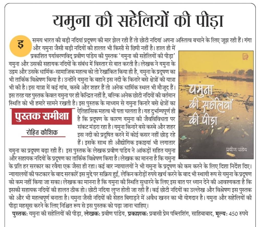
Book यमुना की सहेलियों की पीड़ा यह पुस्तक न केवल यमुना की प्रमुख सहायक नदियों—चंबल, बेतवा, केन, हिंडन, काली, साहिबी आदि—की मौजूदा स्थिति का विश्लेषण करती है, बल्कि यह भी बताती है कि किस प्रकार अनियंत्रित औद्योगीकरण, अवैध रेत खनन और जल संसाधनों के अंधाधुंध दोहन ने इन नदियों को दम तोड़ने के कगार पर ला दिया है। क्या हम अब भी इन सहायक नदियों को पुनर्जीवित कर सकते हैं? क्या यमुना को उसके मूल स्वरूप में लौटाने की कोई संभावना है? इस पुस्तक में इन ज्वलंत प्रश्नों पर गहन चर्चा की गई है और संभावित समाधान प्रस्तुत किए गए हैं। यह शोधार्थियों, पर्यावरणविदों, नीति-निर्माताओं और आम नागरिकों के लिए समान रूप से उपयोगी सिद्ध होगी। https://tinyurl.com/ye8znnm7
Panel to look into bypassing of new flow meters at STPs High Court have set up a panel to investigate if a substantial portion of water is bypassing the newly installed flow meters and sensors in 25 STPs meant to monitor pollution in the Yamuna. A special bench of Justices Prathiba M Singh and Manmeet PS Arora said the “entire purpose of STPs would be defeated if the water/sewage is permitted to bypass the flow meters and the sensors at the outlet”. Ordering a team of officials, lawyers and petitioners to inspect each of the flow meters, the high court expressed its opinion that “since 35 out of the 37 STPs are now stated to be having flow meters and are part of an online monitoring system with the sensors, the same deserve to be inspected to get the actual position from the ground”. https://timesofindia.indiatimes.com/city/delhi/panel-to-look-into-bypassing-of-new-flow-meters-at-stps/articleshowprint/121006282.cms (08 May 2025)
DJB plots a cleaner course for Yamuna DJB proposes to construct STPs and decentralized STPs at the mouth of several drains. Of the 40 DSTPs, 13 will be funded by the central govt under the AMRUT 2.0 scheme. Tenders for these projects are expected to be floated this month. The consolidated scheme for the remaining 27 DSTPs has been approved by Verma. Tenders for these are likely to be issued by the end of this month, said officials. Officials said that Verma had set June 2027 as the date to complete most of the draintapping operations and would brook no delays. https://timesofindia.indiatimes.com/city/delhi/delhi-jal-board-plots-a-cleaner-course-for-yamuna/articleshowprint/120926594.cms (06 May 2025)
Clean River or Report? The DPCC recently released a report claiming a significant breakthrough in the fight to clean the Yamuna River — a reported 90%+ drop in fecal coliform levels. At first glance, this seems like a major success for the government’s multi-crore rejuvenation projects. But a closer look at the data reveals a puzzling contradiction. Activist Pankaj Kumar has publicly questioned the credibility and interpretation of the data. As legal and environmental watchdogs continue to scrutinize these developments, one thing is clear: a cleaner Yamuna cannot be built on selective data. Transparency, comprehensive treatment, and consistent monitoring across all pollution parameters are essential for genuine progress. https://verdicto.news/yamuna-cleanup-reality-vs-reports (06 May 2025)
Volunteers battle waste along Yamuna For the past six years, Pankaj Kumar and a handful of volunteers group that calls itself Team Earth Warriors have been cleaning the Yamuna’s banks at Kalindi Kunj every Sunday. But every week, they find the riverine area as polluted as earlier — with garbage, medical waste, discarded clothes, idols and puja material, polybags, liquor bottles, sometimes even carcasses of animals, either dumped there or ferried by the river. https://timesofindia.indiatimes.com/city/delhi/never-ending-cleanup-volunteers-battle-waste-along-yamuna/articleshowprint/120906939.cms (05 May 2025)
New features at Baansera park Baansera is spread across 40 hectares. The new features planned for Baansera include a recreational club, food court offering multiple cuisines, an information kiosk for adventure sports, an organic haat, and a tent city with small tent accommodation to increase tourism. DDA plans to add a children’s play area, built using bamboo, bamboo miniatures of Delhi monuments, watchtowers made of bamboo and other miscellaneous bamboo amenities. DDA has started the process of appointing a technical advisor for conducting feasibility studies and selecting a developer or concessionaire who will operate and mainten Baansera on a public private partnership (PPP) mode.
Some of the features that already exist at Baansera are water bodies, mounds, pathways, forest trail, bamboo structure works, children play area, elephant family sculpture, musical fountain, flower bed area and a 25,000sqms “top plateau”. Baansera has been developed as a public park at a former wasteland site along the Yamuna and features more than 15 varieties of 30,000 bamboo plants. DDA has also planted the medicinal Lakadong turmeric plant from Meghalaya under the thick bamboo groves over two acres of land at Baansera. https://www.hindustantimes.com/cities/delhi-news/tent-city-organic-haat-adventure-zone-among-new-features-at-baansera-in-delhi-101745173405473.html 21 April 2025
DJB’s Rs 3,104-cr proposal DJB has proposed the construction of 40 decentralised STPs and extension of sewer lines in Outer Delhi at an estimated cost of Rs 3,104.57 cr. The proposal, discussed in a recent meeting of the Finance Dept’s Expenditure Finance Committee (EFC), is aimed at covering 416 unauthorised colonies and 115 villages across seven Assembly constituencies, benefitting approximately 35 lakh residents.
The project is being funded under the Centre’s AMRUT 2.0 scheme. It proposes a three-month planning period followed by 18 months of execution, excluding monsoon delays. For 2025-26, an amount of Rs 613.4 crore has been earmarked. In the minutes of the meeting, it was emphasised that “the timeline is the essence of a project”.
The EFC directed DJB to include “stringent penalty clauses in the tender documents to assure high-quality construction and adherence to the stipulated timeline.” A Project Management Consultant (PMC) will be appointed, and the Urban Development Department has been instructed to establish a dedicated Project Management Unit (PMU) for oversight. https://indianexpress.com/article/cities/delhi/40-stps-extension-of-sewer-lines-djbs-rs-3104-cr-proposal-to-clean-yamuna-9989496/ 08 May 2025 Delhi currently operates 38 STPs across 20 locations, with a total treatment capacity of 712 MGD against an estimated sewage generation of 792 MGD. By December 2026, the capacity is expected to rise to 814.06 MGD through upgradation of 14 STPs and construction of three new plants at Sonia Vihar, Delhi Gate, and Okhla, which are expected to add 47 MGD. https://indianexpress.com/article/cities/delhi/40-stps-extension-of-sewer-lines-djbs-rs-3104-cr-proposal-to-clean-yamuna-9989496/ 08 May 2025
DJB plans more D/STPs Of the 40 DSTPs, 13 will be funded by the central govt under the AMRUT 2.0 scheme. Tenders for these projects are expected to be floated this month. The consolidated scheme for the remaining 27 DSTPs has been approved by Verma. Tenders for these are likely to be issued by the end of this month, said officials. Officials said that Verma had set June 2027 as the date to complete most of the drain tapping operations and would brook no delays. https://timesofindia.indiatimes.com/city/delhi/delhi-jal-board-plots-a-cleaner-course-for-yamuna/articleshow/120926594.cms 06 May 2025 अधिकारियों ने कहा कि वर्मा ने अधिकांश नाला टैपिंग कार्यों को पूरा करने के लिए जून 2027 की तारीख तय की है और कोई देरी बर्दाश्त नहीं की जाएगी। https://navbharattimes.indiatimes.com/metro/delhi/other-news/delhi-jal-board-yamuna-action-plan-to-prevent-untreated-sewage-water-from-drains/articleshow/120923856.cms 06 May 2025
Govt to constitute unit to monitor cleaning efforts The Urban Development Department of the Delhi government plans to constitute a project management unit for timely and efficient completion of works for cleaning the Yamuna related to the DJB. According to officials, the project management unit with officials of the urban development and finance department as members would oversee the river cleaning projects and ensure that there is no cost-escalation or missed deadlines.
“The Urban Development Department shall constitute a Project Management Unit for the entire project,” says the minutes of the expenditure and finance committee meeting. The DJB also plans to hire a private agency to operate and maintain sewage treatment plants for the next 10 years. The entire cost of the project has been pegged at Rs 3,104 crore, funds for which have been approved by the government. https://theprint.in/india/delhi-govt-to-constitute-unit-to-monitor-yamuna-cleaning-efforts/2618642/ 07 May 2025
Govt’s new plan From enhancing environmental flow of the river to managing drains and removing encroachments from floodplains through a dedicated Special Task Force, the Government has finalised a 30-point action plan to rejuvenate the Yamuna, The Indian Express has learnt. The plan, which involves the Central and Delhi governments, was drawn up following a high-level meeting chaired by PM Modi on April 16 to review the clean-up and address the capital’s drinking water concerns. https://indianexpress.com/article/india/30-point-action-plan-centre-plans-clean-up-yamuna-9976466/ 02 May 2025
Govt orders third-party audit of all STPs While this is welcome provided there is indeed an independent audit, this cannot be a once in a lifetime audit but should be done regularly. More important is to fix the governance of the STPs to make it more transparent, accountable and participatory. Water minister Parvesh Verma directed the DJB on Wednesday (April 23) to conduct a third-party audit of all 37 STPs in the capital. In a recent review meeting with the sewage management wing of DJB, which was also attended by the private operators of some of the plants, the minister was apprised of the current capacity and status of ongoing rehabilitation and upgradation works of the STPs across the city. The minister found out that several STPs were operating below their installed capacity.
Of the 37 STPs currently operational, 18 are undergoing upgradation to improve their performance. Additionally, 3 new STPs at Sonia Vihar, Delhi Gate and Okhla are expected to enhance the overall sewage treatment capacity by approximately 47 MGD. Delhi govt has kept aside Rs 500 crore for the repair and modernization of STPs in the 2025-26 financial year, while an additional Rs 250 crore has been earmarked for replacing old and damaged sewer lines. https://timesofindia.indiatimes.com/city/delhi/yamuna-cleaning-govt-orders-third-party-audit-of-all-stps/articleshow/120560482.cms 23 April 2025 The majority of Delhi’s STPs — 30 out of 37 — are operated by private contractors under outsourcing arrangements. The water minister has instructed these operators to ensure that both capacity and quality standards are strictly maintained. https://www.tribuneindia.com/news/delhi/delhi-parvesh-verma-orders-audit-of-stps-to-boost-yamuna-clean-up-efforts/ 24 April 2025
Agenda for cleaning the river Delhi has spent over Rs 6,000 crore in just four years for cleaning the Yamuna – but the river remains as polluted as ever. This briefing document assesses the key reasons and offers an agenda for action. https://www.cseindia.org/yamuna-the-agenda-for-cleaning-the-river-12691 08 May 2025 The report emphasized the importance of determining the actual volume of sewage being generated in the city rather than relying on estimations. CSE further flagged several discrepancies in data, like wastewater generation, faecal desludging, water being consumed in the city, even the population to assess per capita daily consumption of water. “Wastewater is estimated as 80% of supplied water. The problem is that we don’t know for sure how much wastewater is being generated since there is no clear data on Delhi’s population or the amount of water being supplied through tankers or from groundwater sources,” said Narain. CSE also said that currently 10-14% of treated water was reused and urged not mixing the treated and untreated wastewater by discharging them into drains. https://timesofindia.indiatimes.com/city/delhi/delhis-2-yamuna-stretch-behind-80-of-its-pollution-why-plan-needs-rethink/articleshow/121006281.cms 08 May 2025 The report, titled ‘Yamuna: The Agenda for Cleaning the River’, noted: “…it is clear that cleaning the river will require more than money. It will need a plan, which recognises the reality that Delhi, like many other cities of India, is a city where the bulk of its people live in unauthorised areas, where sewage is not intercepted and therefore, not treated.” https://indianexpress.com/article/cities/delhi/cleaning-yamuna-will-require-more-than-money-it-will-need-a-plan-cse-9991843/ 09 May 2025 The report highlights a troubling disconnect between investment and impact. Delhi has 37 STPs, reportedly covering 84% of its wastewater, with nearly 80% of households connected to the sewer system. Yet, the 22-km stretch of the river in Delhi shows no signs of revival. https://www.newindianexpress.com/cities/delhi/2025/May/09/citys-yamuna-cleaning-plan-needs-reset-not-just-money-says-report 09 May 2025
Yamuna Nagar नकटी नदी के गलत बने तटबंध को हटाने का काम शुरू साढौरा: अमित सेतिया ने बताया कि सिंचाई विभाग ने नदी में सरकारी जमीन पर किए कब्जों से हटकर तटबंध बना दिया। तटबंध बनाए जाने से केवल अवैध कब्जे ही सुरक्षित हुए, वहीं तटबंध बनाए जाने से नकटी नदी का प्रवाह क्षेत्र का दायरा भी सिमट गया। नतीजन बारिश के दिनों में नकटी नदी का उफनता पानी आगे जाने के बजाय कस्बे के कई मोहल्लों में जलभराव का कारण बन गया। (https://www.amarujala.com/haryana/yamuna-nagar/work-to-remove-wrongly-constructed-embankment-of-nakti-river-begins-yamuna-nagar-news-c-246-1-sknl1022-137379-2025-05-08 08 May 2025)
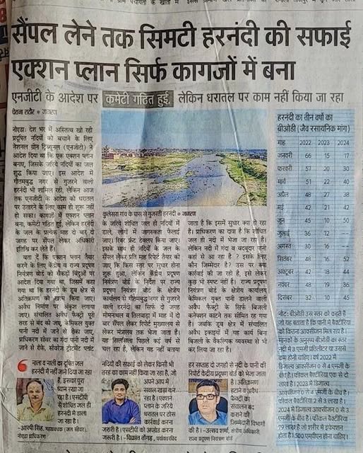
Noida सैंपल लेने तक सिमटी हरनंदी की सफाई एक्शन प्लान बस कागजों में (Dainik Jagran May 2025) https://www.facebook.com/share/p/16TZfPvRx9/
Any type of construction including farmhouses, road, colonies that have been built in Yamuna floodplains area will be soon razed by the Noida Authority after survey, said officials. The action comes after a meeting chaired by Chief Executive Officer (CEO) Lokesh M directing officials to identify and demolish the illegal constructions in the Hindon-Yamuna floodplains. https://www.millenniumpost.in/delhi/noida-to-raze-illegal-constructions-on-yamuna-floodplains-609903 (09 May 2025) बैठक में मुख्य कार्यपालक अधिकारी महोदय द्वारा निर्देश दिये गये कि डूब क्षेत्र में अवैध रूप से कालोनी विकसित करने वाले एवं फार्म हाउस की विक्रय करने वाले प्रमुख व्यक्तियों को चिन्हित कर उन्हें भू-माफिया घोषित कर उनके विरूद्ध कठोर कार्यवाही सुनिश्चित की जाय। https://jaihindjanab.com/bulldozer-will-be-used-on-illegal-construction-in-yamuna-hind-area-ceo-dm-have-made-full-preparations/ 08 May 2025
Mathura How persistent pollution in Yamuna river has ruined traditional floodplain crops of melons. https://www.livehindustan.com/uttar-pradesh/mathura/story-yamuna-pollution-destroys-mont-watermelon-and-melon-farming-201746565280686.html 07 May 2025
RIVERS BIODIVERSITY
Report Polluted water can also harm insects Humans often focus on insects such as bees and butterflies because they are more visible, but many insects spend much of their life underwater, where they face another set of threats. For instance, dragonflies are aquatic when they are juveniles. The threats at this stage of life are no less severe but are entirely different from those facing adults. When water levels in streams or ponds decrease, that reduces young dragonflies’ habitat. These insects can also be threatened by water pollution from runoff and increases in water temperature with climate change. https://theconversation.com/humans-are-killing-helpful-insects-in-hundreds-of-ways-simple-steps-can-reduce-the-harm-255844 (08 May 2025)
Human activity affecting birds’ migration Migrating birds use the sun, stars, coastlines and large bodies of water to guide them on their journeys across the world. But some places where they stop to rest and refuel along the coasts are being altered by floods connected to rising sea levels.
Small crustaceans, which are an important food source for migratory birds, can struggle to build their shells and skeletons in oceans made more acidic by having to absorb more carbon dioxide. And this has a knock-on effect on migratory birds. Without sufficient food, they are less likely to survive arduous journeys or successfully reproduce.
Birds, like humans, are also threatened by the increasing intensity and frequency of extreme weather events such as storms. Strong winds can drag them down and kill them. Equally, climate change can impact how migratory birds behave. Warmer temperatures can remove the threat of food scarcity, leading birds to shorten their routes or not flying back to their original habitat at all. https://timesofindia.indiatimes.com/home/environment/how-climate-change-is-altering-bird-migration/articleshow/121076937.cms (11 May 2025)
FISH, FISHERIES, FISHERFOLKS
Arunachal Pradesh 90K fingerlings released into rivers Ninety thousand fingerlings, sourced from Lakhimpur, Assam, were released into the Tewai and the Taru rivers here in Longding district on Monday (May 05) as part of a river ranching programme. The fish stock comprised six different species: rohu, katla, mirga, common carp, bighead and grass carp. https://arunachaltimes.in/index.php/2025/05/07/90000-fingerlings-released-into-rivers/ (07 May 2025)
SAND MINING
SANDRP Interview Blog Lawyer Sankar Pani: Citizen Monitoring Key to Improve Riverbed Mining Governance My litigation work has raised several issues which are then incorporated in EC making it part of regulatory systems. But mere incorporation without any compliance or monitoring makes no sense. As far as the regulatory regime is concerned, there are enough provisions. It’s all about monitoring and enforcement. https://sandrp.in/2025/05/09/odisha-lawyer-sankar-prasad-pani-interview-citizen-monitoring-key-to-improve-riverbed-mining-governance/ (09 May 2025)
Uttar Pradesh Unregulated sand mining disrupts riverine ecosystems: SC The Supreme Court on May 8 upheld an NGT decision quashing an e-auction notice of UP govt for sand mining and said there should be “zero tolerance” for such unregulated activities as it disrupted “riverine ecosystems”. The top court further directed before granting an environmental clearance for sand mining, preparation of a district survey report (DSR) was mandatory. A bench comprising Justices P S Narasimha and Manoj Misra dismissed the appeals on February 13, 2023. “We unequivocally uphold the law and the regulations governing sand mining, demanding zero tolerance for unauthorised activities, strict adherence to these regulations is non-negotiable,” Justice Narasimha, who penned the 34-page verdict, said. He added, “Unregulated sand mining disrupts riverine ecosystems, alters natural flow patterns, and leads to erosion and habitat loss. Aquatic biodiversity suffers as spawning grounds are destroyed and water quality deteriorates. The destabilisation of riverbanks increases flooding, risking human life and animal habitat alike.” Illicit sand trade, the judge said, often operated under the shadow of organised crime, undermining the rule of law and weakening governance structures.
-The bench held a draft DSR was not tenable and it could never be the basis for a recommendation by the District Level Expert Appraisal Committee (DEAC) and for the District Level Environment Impact Assessment Authority (DEIAA) for B2 category projects relating to mining of minor minerals lease area less than or equal to 5 hectare to grant environment clearance. The bench said a complete ban on sand mining would certainly restore ecology and preserve the environment.
– “Another important facet of DSR is that it shall be prepared for all the districts and the draft is to be placed in the public domain. There is a requirement for keeping a copy of DSR in the collectorate. It must also be posted on the district’s website for 21 days. After comments are received, they shall be considered and if found correct, they will be incorporated in the final report,” it said. The final DSR would then be finalised within six months by the DEIAA and the lifetime of the report is five years, it added. “After five years the existing DSR will not be tenable and a new DSR will have to be prepared and finalised. The purpose and object of prescribing a lifetime of five years for subsistence of a DSR is for the reason that the position of ecology and the environment is rapidly changing and the position that existed five years back, may not subsist for later days,” it added. https://theprint.in/india/sc-upholds-quashing-of-e-auction-in-up-says-unregulated-sand-mining-disrupts-riverine-ecosystems/2619675/ (08 May 2025)
Opinion River ecosystems in the shadow of sand mining As illegal mining alters the riverbeds and drains life from these once-thriving arteries, the need for sustainable management becomes urgent. To preserve rivers as living, life-giving entities, we must shift from exploitation to stewardship.
-Continuous removal of a sand layer of the riverbed can lead to the destruction of the habitat of microorganisms maintaining the river’s biological health and endanger ecosystem services. Increased turbidity due to sand mining in active channels can block sunlight, hinder photosynthesis, and exterminate aquatic life like diatoms, macroinvertebrates, benthic algae, and fish eggs.
-The shallow and braided flow impedes fish migration between flows and pools, disrupting the entire food web. Studies show that rampant sand mining has threatened species like the Ganges River dolphin and Chambal River’s gharial. Further, unregulated sand mining results in the loss of aquatic flora and also riverside vegetation due to lowered water table, damaging the ‘Shaded Riverine Aquatic Habitat’ (SRA), which provides shade, bank stabilisation, and nutrients to numerous organisms. (BKP Sinha and Ajay Jha former PCCFs UP & Maharashtra)https://www.dailypioneer.com/2025/columnists/river-ecosystems-in-the-shadow-of-sand-mining.html (18 April 2025)
Haryana Yamuna faces mining onslaught The Yamuna, once a lifeline for Yamunanagar district, is now under severe threat as rampant illegal mining tears through its ecosystem, jeopardising agriculture, biodiversity, and the lives of communities that depend on it. Driven by soaring demand for sand and gravel in construction, unregulated extraction has turned the riverbed into a site of unchecked exploitation. Heavy machinery digs deep into the Yamuna’s banks, altering its natural course, eroding sediment, and clouding the water with pollutants that smother aquatic habitats.
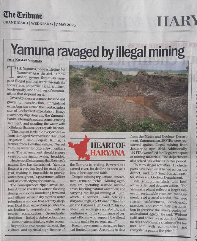
-Despite existing regulations, enforcement remains feeble. “Mining agencies are operating outside allotted areas, blocking natural water flow, and carrying out illegal mining at night, which is banned,” said Advocate Waryam Singh, a petitioner in the Punjab and Haryana High Court. “This violates rules, endangers aquatic life, and continues with the connivance of corrupt officials who support the illegal mining mafia for personal gain.” https://www.tribuneindia.com/news/haryana/yamuna-faces-mining-onslaught/ 07 May 2025
रादौर: गांव जठलाना में दोस्तों के साथ यमुना नदी में नहाने गए एक युवक की यमुना नदी में एक गहरे कुंड में डूबने से एक 15 वर्षीय बच्चे की मौत हो गई। गांव जठलाना का यह युवक (May 04) यमुना नदी में नहाने के लिए घर निकला था। जब वह यमुना नदी के अंदर दोस्तों के साथ नहाने के लिए गया तो *यमुना नदी के अंदर खनन के लिए पोपलेन मशीनों द्वारा खोद गए गहरे कूंड मे गिर जाने से युवक कीं डूबने से मौत हो गई।* आसपास के लोगों व गोताखोरों की मदद से बच्चे के शव को बाहर निकाला गया। https://m.haryana.punjabkesari.in/haryana/news/15-year-old-boy-who-went-to-bathe-in-yamuna-die-2147589 07 May 2025
6 officials chargesheeted over mining After being in the denial mode for months, Haryana has finally accepted illegal mining in its territory at Rawa village of Nuh on the Rajathan border since 2011 and chargesheeted six mining officials. Though the area fell under Haryana’s revenue jurisdiction, leaseholders from Rajasthan were carrying out illegal mining here. https://www.tribuneindia.com/news/haryana/6-hry-officials-chargesheeted-over-mining-along-raj-border/ 07 May 2025
बाँदा मे इस वक्त लगभग 15 मौरम खण्ड संचालित है। इनमे से मौरम निकासी करते परिवहन / ओवरलोड ट्रक, डंफर आदि को 200 रुपया तहबाजारी रसीद का देना होता है। इसके लिए बाकायदा गांव के एंट्री क्षेत्र मे बैरियर लगता है। वहीं तहबाजारी वसूली वाले इत्मीनान से यह काम करते है। लेकिन 200 रुपया निर्धारित शुल्क की जगह बाँदा मे 400 रुपया वसूली की गई। ज़िला पंचायत अध्यक्ष व सदर विधायक की आपसी तनातनी मे यह विवाद ऐसा उलझा कि आज तक राजनैतिक रार है। https://soochanasansar.in/the-contract-for-tehbazari-is-rs-200-but-rs-400-is-collected-the-roads-of-the-district-banda-rural-village-are-bad/ 02 May 2025
Uttarakhand श्रीनगर में रिवर ट्रेनिंग और रिवर ड्रेजिंग के पट्टों के नाम पर अलकनंदा नदी में जमकर अवैध खनन. https://www.youtube.com/watch?v=nWWl5_Srv1g (10 May 2025)
Goa Govt seeks Andaman like relaxation CM Pramod Sawant has urged Union govt to relax the sand extraction norms for the state akin to those stipulated for the Andaman and Nicobar Islands. He sought amendments to the CRZ notifications of 2011 and 2019 besides sustainable mining guidelines. Sawant said that the prohibition of sand extraction under these notifications adversely affected the availability of sand besides the livelihood of dependent families. “The conditions have culminated in a difficult situation for the administration to make available the required sand for the growing construction industry. Hence, the state needs certain relaxation for the purpose of extraction of sand under the prevailing CRZ rules and regulations,” Sawant said.
“It was informed that the ministry will consider and resolve the difficulties faced. In case of the Andaman and Nicobar Islands, permission for extracting sand at identified and approved sites by the Institute of Ocean Management (IOM) Chennai, with the quantity of sand to be extracted is fixed and the activity will be monitored by a committee,” Sawant said.
State govt conducted EIA/EMP modelling studies under the aegis of the National Institute of Oceanography (NIO), which reported that there is not much sand available in the upper reaches of the river. “The available riverine materials like cobbles, pebbles, etc. are reducing the flow area of the river and causing floods. These deposits also reduce water storage capacity in bandharas and barrages, on which drinking and agriculture water requirements depend,” Sawant said.
Earlier, state govt was investing a lot of funds to desilt these storage barrages, he said adding, “Now, I have initiated steps to auction the river pebbles, etc. The auctioneer will be allowed to desilt the riverbed span to the level and extent permitted as per the norms. This will generate revenue to the state and create employment opportunities.” https://timesofindia.indiatimes.com/city/goa/give-goa-relaxation-for-sand-mining-like-andaman-islands-cm-to-centre/articleshow/121066543.cms (11 May 2025)
Odisha Illegally stockpiled sand seized & auctioned A massive amount of sand, illegally extracted and stockpiled near the Sonali River in Kaptipada, was seized by a joint team of officials from the Mining Department, Tahasildar, and Police, officials said on Saturday (March 15). Acting on a tip-off, the team raided the site and found over 230 truckloads of sand, valued at a significant amount. The sand had been illegally extracted and stockpiled for smuggling. https://kalingatv.com/odisha/odisha-illegally-stockpiled-sand-seized-and-auctioned-by-tahasildar-in-mayurbhanj/ (15 March 2025)
Tamil Nadu Murugan stripped o Mines and Minerals Though there was no ofcial word on the reason behind the sudden change in portfolio, it is believed that allegations of wide-scale corruption in the Mines and Minerals department led to the development. The department is already under the scanner of central agencies like the Enforcement Department (ED) which is probing the mining scam in Tamil Nadu; the agency had even summoned district collectors last year. https://www.deccanherald.com/india/tamil-nadu/durai-murugan-stripped-off-mines-and-minerals-given-law-portfolio-3531718 (08 May 2025)
Karnataka MLA disqualified after conviction in mining case Tainted mining baron and BJP MLA Gali Janardhan Reddy was disqualified from the Karnataka Legislative Assembly on Thursday following his conviction in the 14-year-old Obulapuram mining case. The disqualification will extend for six years from the date of conviction, May 6, 2025, unless the conviction is stayed by a competent court. https://timesofindia.indiatimes.com/india/mla-reddy-disqualified-after-conviction-in-mining-case/articleshow/121009486.cms (09 May 20250
WETLANDS, LAKES, WATER BODIES
Punjab Kanjli Wetland suffers neglect despite Ramsar status Covering approximately 183 hectares, the Kanjli Wetland was declared a Ramsar site in 2002 due to its ecological significance. The wetland, part of the sacred Kali Bein rivulet associated with Guru Nanak Dev Ji, historically supported a diverse ecosystem of birds, fish and aquatic plants. However, it now faces a grim reality marked by pollution, decay and administrative indifference.
-Despite its Ramsar recognition, Singh said, there has been no comprehensive management plan implemented for the site. Infrastructure meant for tourists lies broken or missing and the wetland itself is choked with water hyacinth-an invasive species that deprives aquatic life of oxygen.
-Residents alleged that untreated waste from local industries and settlements is being dumped into the Kali Bein, with little oversight from the Pollution Control Board or local authorities. Tourism, once a source of livelihood for surrounding communities, has sharply declined due to poor maintenance, lack of security and absence of basic amenities.
-INTACH has urged the Punjab government to declare an ecological emergency for the Kanjli Wetland. The organisation has called for an independent audit of previous restoration promises and strict enforcement of pollution control in the Kali Bein catchment area. https://www.tribuneindia.com/news/jalandhar/kanjli-wetland-suffers-neglect-despite-ramsar-status/ (10 May 2025)
Gujarat State improves its lake, reservoir areas by 577 sq km: Study A recent study by IIT Roorkee indicated that Gujarat recorded a rise in lentic water bodies (LWB) by 577 sq km from 1990 to the 2020s. Water bodies with still water, such as ponds, lakes, and reservoirs, are identified as LWB. Based on satellite data analysis along with other parameters, researchers indicated Gujarat had 308 sq km area of LWB in 1990, which increased to 885 sq km, marking a rise of 187%. The study, ‘Exploring the Intersection of Socioeconomic and Environmental Changes and Their Impact on India’s Lentic Water Systems,’ by Pooja Singh, Tanya Nema, Basant Yadav, Abhay Raj, and Ilhan Özgen from IIT-R and Germany-based Technical University of Braunschweig, is in preprint of Elsevier journal Environmental and Sustainability Indicators.
– According to the study, LWBs in Punjab fluctuated from 21.2 sq km to 30.9 sq km over three decades, whereas in West Bengal, the range was 557.3 sq km to 459.8 sq km. The LWB area in Kerala grew from 44.5 sq km to 72.3 sq km over three decades, the second highest among the four states after Gujarat. More importantly, the study highlighted that the LWB trend can be attributed to the overall positive trend of total water – growing from 27,225.3 sq km to 36,231 sq km in three decades. ‘Overall, the total water area exhibited differing trends throughout states, with Gujarat showing the most substantial positive growth and Punjab showing the highest drop, despite an ongoing rise in the number of LWB,’ indicated the study. http://timesofindia.indiatimes.com/city/ahmedabad/in-3-decades-guj-improves-its-lake-reservoir-areas-by-577-sq-km-study/articleshowprint/120909143.cms (06 May 2025)
WATER OPTIONS
Video Need to talk about water The sustainable use of water intersects climate change, agriculture, politics, pollution, displacement and migration, but also much more. We need more interdisciplinary conversations around water, conversations that connect education, activism, science and sustainable choices. https://www.youtube.com/live/pDXMq6ff8xk (08 May 2025)
In Quest of New Water Adequately treating sewage will make it a precious resource resulting in less pollution and improvement in the health of the rivers, water bodies in India. https://www.youtube.com/watch?v=E0PFsvRfbj4 (10 May 2025)
Bengaluru Green buildings gain ground From using natural materials to installing rainwater harvesting systems, city architects see a shift in people’s interests. This has become especially evident post Covid, said Yashaswini Sharma, an architect who specialises in the conservation of buildings. https://www.deccanherald.com/india/karnataka/bengaluru/green-buildings-gain-ground-among-people-as-climate-change-hits-home-3530024 (08 May 2025)
Research Engineered bacteria can degrade 5 wastewater pollutants Five gene clusters have been integrated into the bacterium Vibrio natriegens to engineer a strain that can remediate five organic pollutants — toluene, phenol, naphthalene, biphenyl and dibenzofuran — in industrial waste water and saline soil. https://www.nature.com/articles/d41586-025-01371-x (07 May 2025)
GROUNDWATER
Telangana Red zone of overexploited water basin increases by 36% Mapped across the State, chunks of areas in Medchal-Malkajgiri, Medak, Siddipet, Kamareddy, Nizamabad and Rangareddy are now in the red zone showing water stress. In contrast, the eastern districts like Mulugu, Warangal, Mahbubabad, Suryapet, and Khammam are water-stress free as are the northern districts of Asifabad, Mancherial, Adilabad, Jagtial and Peddapalli.
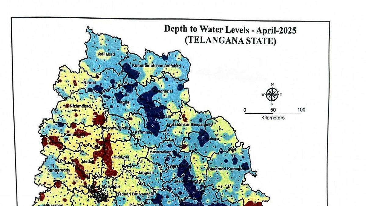
“Telangana has 85% land that has the subsurface of igneous rock, which is hard and has limited permeability. Only 15% land in the State has sedimentary and metamorphic rock surface with greater permeability. This is a limiting factor for the recharge of ground water. Aggravating the situation, the anthropogenic activity with road surfaces and concretisation has led to increased runoffs reducing the recharge of aquifers,” says Mr. Laxma. https://www.thehindu.com/news/national/telangana/average-groundwater-table-up-in-telangana-but-red-zone-of-overexploited-water-basin-increases-by-36/article69556772.ece (09 May 2025)
Himachal Pradesh Govt tells industries, builders to register for gw use Himachal Pradesh Ground Water Authority has mandated all commercial and industrial users to register by June 30, failing which they will face punitive action. All non-registered commercial and industrial users must apply via the Jal Shakti Department portal or at http://www.emerginghimachal.hp.gov.in. After this date, the portal will be disabled, and no further applications will be entertained.
-“This is the last opportunity for non-registered users to comply,” Sumit Sood, Executive Engineer, HP Ground Water Authority, Shimla reiterated. He further disclosed that around 100 commercial entities remain unregistered, and two firms were recently fined Rs 11.30 lakh for violating the HP Groundwater Act.
The directive comes amid concerns over indiscriminate groundwater extraction by industries in areas like Nalagarh, Paonta Sahib and Una, where multiple borewells have been dug in close proximity. These establishments draw substantial volumes of water daily, risking over-exploitation of this vital resource.
To prevent excessive water withdrawal, industries and infrastructure projects are required to submit an Impact Assessment Report prepared by accredited consultants and in consultation with a senior hydrogeologist. This regulation applies particularly to regions where groundwater is rated as critical or vulnerable. However, enforcement remains lax. https://www.tribuneindia.com/news/himachal/govt-tells-industries-builders-to-register-for-groundwater-use/ (10 May 2025)
URBAN LAKES, WETLANDS
Mumbai HC contemplates committee for conservation of Thane flamingo sanctuary The division bench of chief justice Alok Aradhe and justice Makarand Karnik expressed the need for such a committee after senior advocate and amicus curiae Janak Dwarkadas called for targeted action on a host of issues to ensure the long-term ecological health of the sanctuary. The senior lawyer is assisting the court in suo motu proceeding to monitor the conservation and preservation of three Ramsar sites in Maharashtra – Nandur Madhyameshwar Wildlife Sanctuary, Lonar Lake, and Thane Creek Flamingo Sanctuary. The proceeding was initiated pursuant to Supreme Court orders in December 2024 to monitor 85 Ramsar sites across the country. https://www.hindustantimes.com/cities/mumbai-news/hc-contemplates-committee-for-conservation-of-thane-flamingo-sanctuary-101746731243382.html (09 May 2025)
BMC to move SC over HC order on Kanjur landfill Days after the Bombay high court declared 120 hectares of the Kanjurmarg dumping site a protected mangrove forest and ordered its restoration within three months, the BMC is preparing to file a Special Leave Petition (SLP) in the Supreme Court, likely by the end of this week. Civic officials said enforcing the order would cripple Mumbai’s waste management, as approximately 5,900 metric tonnes of solid waste are dumped at Kanjurmarg daily, and the city currently has no alternative site. https://timesofindia.indiatimes.com/city/mumbai/bmc-to-move-sc-over-hc-order-on-kanjur-landfill/articleshow/120909884.cms (06 May 2025)
Protests against mangrove tree felling Residents and greens irked after private contractors started destroying trees at mangrove buffer zone near DPS lake, plot number 3,6 and 7 of sector 52 A. Navi Mumbai Municipal Corporation seized the two JCBs used in the destruction after complaints were made to NMMC office by the residents. https://www.freepressjournal.in/mumbai/navi-mumbai-residents-protest-tree-destruction-in-mangrove-buffer-zone-nmmc-seizes-jcbs (12 Mach 2025)
Chennai WRD removes encroachment from Kovilpadagai lake In line with its efforts to rejuvenate urban water bodies, the WRD has started clearing encroachments in Kovilpadagai lake near Avadi. It is one of the key water bodies in city fringes that has been earmarked to be developed as a drinking water source particularly for Avadi. The department cleared nearly 16 encroached structures and 15 other sites that were fenced in Rajiv Gandhi Nagar and Brindavan Nagar. Officials of the WRD noted that the structures that had freshly encroached the lake area were razed down during the drive carried out with the Revenue department officials. https://www.thehindu.com/news/cities/chennai/wrd-removes-a-portion-of-encroached-structures-in-kovilpadagai-lake-thats-earmarked-to-be-developed-as-drinking-water-source/article69561050.ece (11 May 2025)
Hyderabad Demolition at Sandhya Conventions in Gachibowli The Hyderabad Disaster Response and Asset Protection Agency (HYDRAA) on Tuesday (May 06) conducted demolitions at Sandhya Conventions at Gachibowli after receiving complaints during the HYDRAA Prajavani program. HYDRAA stated that interlopers have encroached upon lands and plots of the Fertilizer Corporation of India Employees Cooperative Housing Society’s layouts, and have undertaken illegal constructions on the property. https://www.deccanchronicle.com/southern-states/telangana/hydraa-carries-out-demolition-at-sandhya-conventions-in-gachibowli-1877227 (06 May 2025)
Ahmedabad Chandola Lake: Drive against encroachment Situated on the southern end of Ahmedabad and spanning an area of 109.6 hectares, Chandola Lake is, perhaps, the least documented of the three major lakes in the city. While much is known about the history of the Sultanate-era Kankaria lake, and Vastrapur lake, situated in the heart of the city, has seen several initiatives for its renovation, Chandola Lake – a British-period water body built for irrigation purposes — has largely been synonymous with the slums that began cropping up on its lakebed over the last several decades.
-According to an AMC document accessed by The Indian Express, a total of 37 of 171 lakes in Ahmedabad remain under encroachment. Chandola lakeside has remained a sore point for years with plans to redevelop it never actually taking off. The AMC budget for 2025-26 says that waterfront development will take place on the lakes, specifically mentioning that encroachers will be resettled. “There is a need to rehabilitate those living in the untenable areas of lakes,” it adds. It further states, “There are about 10,000 kutcha and pucca houses in and around the various lakes. They will be integrated into the PMAY -2 project… A total of 4,000 residences will be built at a cost of Rs 600 crore.” There has been no word on the resettlement since.
-Speaking on the plans to fill the lake, an AMC officer says, “Chandola Lake is not just about demolitions. It is about development… we are thinking about how to put some water into the lake.” According to the officer, “We will require 5,000 to 6,000 million litres. We are exploring whether this water can be brought from the STP at Pirana.” Officials admit that the demolition is not the end of their problem as those evicted were moving to other parts of the city. A senior AMC official admits that this was a problem that had been set forth for consideration but there is no solution yet in sight. https://indianexpress.com/article/cities/ahmedabad/chandola-demolitions-gujarat-bangladeshi-pahalgam-attack-police-immigrants-9982941/ (06 May 2025)
AMC to resettle evicted In a statement on Thursday (May 08), the civic body, which recently conducted its first survey of the encroachments on the city’s largest water body after razing 4,000 residential and commercial structures, said that the size of the entire lake area is 11 lakh square metres of which 4 lakh square metres was under encroachment. It said that 1.5 lakh square metres of these encroachments had been cleared, leaving 2.5 lakh square metres with 10,000 estimated structures still pending. https://indianexpress.com/article/cities/ahmedabad/week-after-demolition-drive-civic-body-gives-in-principle-nod-to-resettle-people-evicted-from-ahmedabads-chandola-lake-9991774/ (09 May 2025)
Guwahati Dighalipukhuri set for green makeover Assam Tourism Development Corporation (ATDC), on Thursday (May 08), launched an eco-friendly project to clean and rejuvenate the historic Dighalipukhuri, one of Guwahati’s most iconic and culturally significant water bodies. Dighalipukhuri, which contains more than 285 million liters of water, has faced severe pollution issues in recent years that led to declining aquatic health, including mass fish deaths. To reverse this deterioration, the project will employ SABRE (Stabilised Aerobic/Anaerobic Bioengineered Reaction Environment) technology—an environment-friendly and sustainable solution vetted by IIT Kanpur. The initiative will be executed over a 4–6 week period.
Dr. Liam Ryan, an environmental scientist from Ireland and the project lead at Welspun, has spent over a decade in India developing sustainable water restoration solutions. The SABRE technology has already been successfully implemented in water body rejuvenation projects across Varanasi, Pimpri, and Pandharpur, demonstrating its effectiveness in restoring polluted lakes and rivers. The effort is part of a broader push to restore polluted water bodies across India, with similar initiatives already carried out in Varanasi’s Durgakund Lake and other water systems using the same SABRE technology. https://assamtribune.com/guwahati/historic-dighalipukhuri-set-for-green-makeover-with-eco-friendly-restoration-project-1576698 (08 May 2025)
Delhi Pond turns concrete dumpyard Despite the allocation of Rs 50 cr for the revival of the capital’s water bodies, the depletion and misuse of these bodies remain as rampant as ever.

In Naraina village, residents say that a local pond has been systematically destroyed over more than a decade through unchecked construction activities, with full complicity and negligence of authorities. https://www.newindianexpress.com/cities/delhi/2025/May/09/pond-turns-concrete-dumpyard 09 May 2025
URBAN WATER
Bengaluru City has more water, distribution is the big worry Says S. Vishwanath, engineer and activist: “There is no scarcity. The critical issue is the distribution network. Will the water reach all of Bengaluru? Of the additional 775 million litres a day of Cauvery water I think we’re pumping only around 300 million out of that, but 775 million litres per day is there. Added to the 1,450 million litres, it is a substantial volume of water… There is a lot of work being done on lakes. There are 183 lakes which are reported to be alive or being worked on. Treated wastewater is being fed into 40 lakes”.
– The problem is that the two biggest lakes, Bellandur and Varthur, continue to be dry. They are being desilted on orders of the NGT in response to a PIL. Bellandur is 906 acres and Varthur is 284 acres. If both were functional, they would be recharging aquifers to the extent of 100 million litres per day at least.
– The city has an unhealthy dependence on groundwater. There are 11,816 borewells which are under the gaze of the government. Of these 2,035 are known to be dry. After last year’s crisis a study has been conducted on the viability of the 11,816 borewells. Meters will be attached to each of them together with a fee for extraction. Additionally, Artificial Intelligence (AI) will be deployed to better manage their use. But this is just the tip of the challenge relating to groundwater. There are an estimated 500,000 tubewells run privately which the government has shown itself unable to monitor. These borewells pump out 800 million litres daily.
– The NGT, responding to a PIL, had ordered the two lakes to be desilted. A committee set up for this purpose decreed that the two lakes be excavated to a depth of six or seven metres. This has led to a problem of what to do with such large amounts of silt. It was at first being given to farmers who decided they didn’t want it because of fears that the silt contained heavy metals. It was then transferred to abandoned quarries, but the quarries can take no more. “They’re still struggling to figure out how and where to get the silt dumped. Plus, there’s been a budgetary constraint. A budget was estimated but the monies haven’t been coming from the state government. I don’t have a number but `300 crore is what is being mentioned as the cost,” says Vishwanath. “It’s clearly a massive amount of silt and transportation by truck itself is huge. The roads don’t have the carrying capacity. The constant movement of trucks going through small narrow lanes sends up large amounts of dust. All these are really problematic issues,” says Vishwanath. “The committee took a rather fundamental view, in my opinion, of what lake cleaning should be. And they were very clearcut that it would have to be this and nothing less. It could have been in proportion to finding the place for the silt to be deposited,” he says.
– “There are 45 aquifers that have been identified, which translates into 45 zones that have been identified where the groundwater table is falling precipitously,” says Vishwanath who sits on the BWSSB’s technical committee.
– Vishwanath has been canvassing for having a million rainfed wells in Bengaluru city. Over time 300,000 have come into existence one way or another. Water harvesting has also been made mandatory for passing building plans and sanctioning water connections. Most importantly, big developers have begun to see water harvesting structures as not just essential for the sustainability of their projects but a plus point for attracting buyers. https://www.civilsocietyonline.com/cities/bengaluru-has-more-water-distribution-is-the-big-worry/ (29 April 2025)
Treated water to flow into Nelamangala lakes Deputy CM DK Shivakumar who is also Water Resources minister, on May 08 addressed a gathering after performing bhoomi puja in Nelamangala for filling up 70 lakes in the districts of Bengaluru Urban, Bengaluru Rural and Tumakuru. It will be done by purifying 240 MLD water under the Vrishabhavathi Lift Irrigation Project.
-Shivakumar also used the platform to speak about the Mahadayi project, and stated that irrigation work in the state has been delayed due to issues related to forest land. “I met the Union environment minister on Wednesday (May 07) and appealed to him about this. He said he will remove the obstacles to the Yettinahole and Mahadayi projects,” the DCM said. https://www.newindianexpress.com/cities/bengaluru/2025/May/09/treated-water-to-flow-into-nelamangala-lakes (09 May 2025)
BWSSB launches 2 schemes BWSSB launched two initiatives — Sanchari Cauvery and Sarala Cauvery — to expand access to piped water and regulate the city’s exploitative water tanker business. Under Sarala Cauvery scheme, apartment complexes can pay 20% of water connection charges upfront, with the remaining 80% will be payable in instalments over one-year period. For small homes measuring up to 600 square feet, a nominal fee of Rs 1,000 will be charged for providing water connection, making it easier for low-income households to access piped water.
Addressing the growing issue of private water tanker operators charging exorbitant rates — from Rs 500 to Rs 3,000 per load — the govt launched Sanchari Cauvery (mobile Cauvery) service to supply clean water at fixed and affordable prices through BWSSB-operated tankers. The pricing structure under the new initiative has been set at Rs 660 for 4,000 litres, Rs 700 for 5,000 litres, Rs 740 for 6,000 litres and Rs 1,290 for 12,000 litres. In the first phase, 250 branded tankers have been deployed. They will deliver water within 24 hours of booking, marking a major step in addressing the city’s water crisis. https://timesofindia.indiatimes.com/city/bengaluru/bengaluru-water-supply-and-sewerage-board-launches-two-schemes-to-improve-water-access-take-on-tanker-mafia/articleshow/121064346.cms (11 May 2025)
BWSSB to roll out EMI scheme Close to 3,500 apartment complexes and one lakh other buildings, including commercial establishments in the city, will soon be able to get Cauvery water connections by paying just 20% of the connection charges as a down payment, with the remaining amount payable in 12 EMIs. The BWSSB is all set to launch the EMI option from Friday (May 09) to help these complexes obtain water connections. With this move, the BWSSB expects to generate revenue of nearly Rs 800 crore. https://www.deccanherald.com/india/karnataka/bengaluru/bwssb-to-roll-out-emi-scheme-for-cauvery-connections-tomorrow-2-3530010 (08 May 2025)
BWSSB in dock as taps spit dirty water A day after residents of Nanjappa Road in Shanthinagar assembly constituency, raised alarm over dirty water supply, the issue has raised its stink on Basappa Road. On Friday (May 09) morning the residents complained about frothy and smelly water pouring out of BWSSB taps. The residents say they have been supplied filthy water by BWSSB for the last 10 years. https://www.newindianexpress.com/cities/bengaluru/2025/May/10/bwssb-in-dock-as-taps-spit-dirty-water-on-basappa-road (10 May 2025)
Chennai WTE plant environmental disaster A press release by the Chennai citizen delegation who visited Hyderabad WTE plant mentioned the local people facing alarming health and environmental consequences due to the plant. The release said nearly 18 waterbodies are highly affected by contamination from the dump yard and plant. “Groundwater, which was once used for drinking purposes, has now become unusable,” said FNCRWA president T K Shanmugam. The delegation urged the GCC to scrap the Chennai waste-to-energy plant proposal and adopt alternative zero-waste solutions. Telangana SPCB found the company — also slated to operate the waste-to-energy plant in Chennai — violated SWM Rules, 2016, by failing to monitor hazardous emissions from incinerator stack like HCL, HF, CO, Cd+, HG and others, since plant’s commissioning in 2020, a release said. https://www.newindianexpress.com/states/tamil-nadu/2025/May/10/kodungaiyur-locals-hyderabad-waste-to-energy-plant-environmental-disaster (10 May 2025)
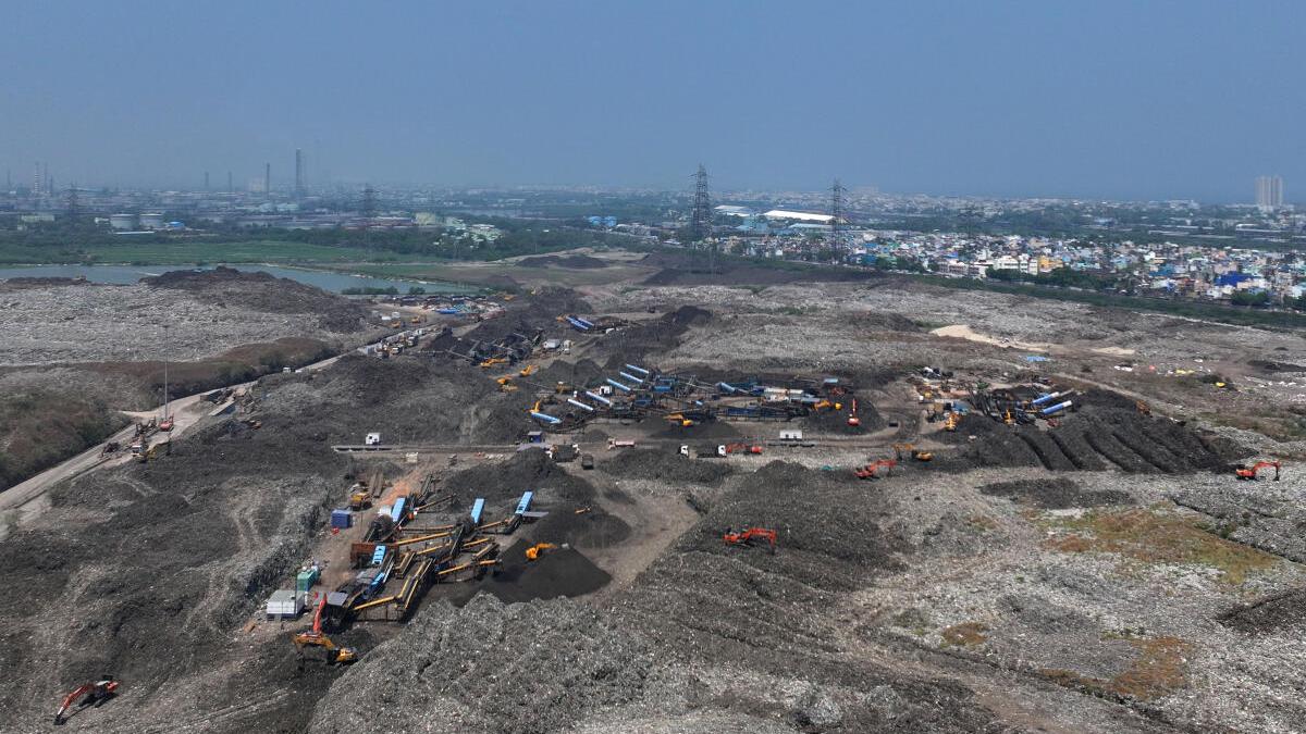
After a delegation of Greater Chennai Corporation (GCC) engineers, led by Commissioner J. Kumaragurubaran, visited the Ivry-sur-Seine waste incinerator in Paris recently, the Corporation plans to proceed with its plans to set up a WTE plant in Kodungaiyur. https://www.thehindu.com/news/cities/chennai/not-a-model-to-emulate-greater-chennai-corporations-wte-plan-faces-more-pushback-residents-experts-cite-studies-revealing-pollution-in-paris-hyderabad-plants/article69561606.ece (11 May 2025)
Krishna water supply to resume According to the WRD, water discharged from the Kandaleru reservoir was likely to reach Tamil Nadu border by Thursday (May 08) evening or early hours of Friday (May 09). Andhra Pradesh authorities had suspended water supply to the city in view of the repair work that was being carried out on the sluice gate of Kandaleru Poondi canal near Kalahasti. https://www.thehindu.com/news/cities/chennai/after-brief-hiatus-chennai-to-receive-krishna-water-supply-from-ap-in-a-few-days/article69549173.ece (08 May 2025)
Hyderabad Water crisis As borewells run dry and groundwater levels plummet to critically low levels, the western corridor of Hyderabad has emerged as the epicentre of the city’s ongoing water crisis. Nearly 60% of all water tanker bookings in April were concentrated in areas stretching from Kukatpally to Serilingampally..
-Data from the HMWSSB reveals that seven of the 22 city divisions—including Kukatpally, Manikonda, Nizampet, and Hafeezpet—accounted for the highest tanker consumption. These zones cover key localities such as Gachibowli, Kondapur, Narsingi and Kokapet.
-The Durgam Cheruvu division, home to Hyderabad’s core IT corridor, alone consumes 20% of the city’s total water tanker supply. During April, areas including Gachibowli, Madhapur, and Kondapur ordered nearly 60,000 tankers out of the total 2.9 lakh bookings. This high demand stems from 70% to 90% of borewells going dry, with groundwater levels dropping to 15-25 metres, making water extraction difficult. https://timesofindia.indiatimes.com/city/hyderabad/tapped-out-acute-water-crisis-pushes-west-hyd-into-the-red/articleshowprint/120857254.cms (03 May 2025)
Pune Decide on pending ECs in 8 weeks: HC The Bombay high court has directed the State Environment Impact Assessment Authority (SEIAA) to ‘consider in accordance with law and within eight weeks’ the pending environmental clearance proposals for housing projects in Pimpri Chinchwad. These proposals are to be considered based on the Comprehensive Environmental Pollution Index (CEPI) score as updated/published by the MPCB for Pimpri Chinchwad in accordance with an email dated Sept 2, 2024, sent by the CPCB, or in accordance with a clarification by the CPCB to the SEIAA on the issue of grant of clearance. CEPI is an index that calculates the environmental quality of industrial areas. Those with a CEPI score between 60 and 70 are termed as severely polluted, while those above 70 are considered critically polluted.
According to MoEFCC’s EIA notification of 2006, projects involving 20,000-1,50,000sqm of construction and township projects covering over 50 hectares or with a built-up area exceeding 1,50,000sqm are classified as ‘B’ and ‘B1′ categories that require environmental clearances following a scrutiny by the SEIAA. On Dec 22, 2014, the MoEFCC issued a notification amending the 2006 EIA notification to declare that the general conditions for the ‘B’ and ‘B1′ category projects would not apply. The same was challenged before the Kerala HC, which decided the matter 10 years later by setting aside the Dec 22, 2014, notification. The Kerala HC ruling formed the basis for the SEIAA to decide at its 279th meeting on Aug 13, 2024, to defer the proposals seeking EC of many (Credai) members and to wait for a clarification to be issued by CPCB. The real estate body challenged this approach as arbitrary. https://timesofindia.indiatimes.com/city/pune/decide-on-pending-environmental-clearance-proposals-for-projects-in-pimpri-chinchwad-in-8-weeks-hc-to-state-panel/articleshowprint/120974523.cms (08 May 2025)
Mumbai Concerns mount over WTE project at Deonar The Brihanmumbai Municipal Corporation’s (BMC) proposed 1800 TPD Waste-to-Energy (WtE) plant at Deonar, the site of India’s largest dumping ground, has drawn strong opposition from residents, activists, and legal professionals, who fear the plant will further deteriorate the already poor air quality in the Govandi area, leading to grave public health consequences. The WtE project, awarded to Chennai MSW Pvt. Ltd., is slated for commissioning by October 2025 at an estimated cost of ₹2,648 crore. The facility, spread over 8.2 hectares, is expected to process 600 metric tonnes of waste daily, generating an estimated 17 million units of energy annually.
Activists and residents have called for an immediate stay on the project and demanded a fresh EIA with stakeholder consultations. They have also urged for comprehensive environmental and health impact studies in the area and the formation of a Special Investigation Team (SIT) to audit the functioning of existing WtE facilities nationwide. An RTI application has also been filed by Mr. Sayyed to seek detailed records on the plant’s clearances, approval processes, and environmental assessments. As the debate continues, the people of Govandi await clarity on whether the pursuit of energy will once again come at the cost of their health. https://www.thehindu.com/news/cities/mumbai/concerns-mount-over-waste-to-energy-project-at-deonar-amid-pollution-fears/article69560775.ece (10 May 2025)
Delhi No water crisis for private players -The water crisis has inadvertently led to a thriving parallel economy across Delhi. As scarcity deepens, multiple private tankers and water providers have moved in to profit from the suffering of residents. An employee of Neelkanth Water Tanker Supplier, based in Hauz Khas, said the demand had been much higher than last year during April. Suppliers providing individual water drums have also seen a significant rise in sales. Shivam Rajput, a Karol Bagh resident, runs a private business from his home. A similar situation persists in Ghazipur, East Delhi, where residents buy water from local shopowners running private supply stations with RO purifiers.
-However, officials at the DJB Chief Executive Officer’s office admitted that the deficit is not being prioritised. “As things stand, there is a deficit but we are not doing anything as such on priority,” an official said. “As population increases and temperatures soar, there will always be a water crisis. Our pipelines are not sufficient enough to tackle the situation.” Delhi’s crisis is not only due to water treatment shortfalls but also a dangerous depletion of groundwater. According to the Central Ground Water Board’s annual report, Delhi extracted 100.77% of its overall groundwater level — drawing 34,453.6 cubic hectare metres while recharging only 34,190.5 cubic hectare metres. https://thepatriot.in/delhi-ncr/water-crisis-hits-everyone-in-delhi-except-the-private-players-69328 (05 May 2025)
Noida Authority to build 20km master sewer line over civic woes The authority had in 2004 roped in UP Jal Nigam for this project. But now UP chief secretary and chairman of the Noida authority Manoj Kumar Singh, has given his nod to the proposal that instead of Jal Nigam, Noida authority will build the project. The Noida authority aims to build the sewer line within 10 months from the date, when the work will begin at the site. It expects that in the next two years, this region will witness 100% development as per the planning, generating 60 MLD additional sewer.
-“We have approved ₹39 crore estimate for 10.2km master sewer line on both sides of Noida Expressway, and the work will be started soon after the formalities are completed,” said RP Singh, general manager of the Noida authority heading the water works department that will build this project. https://www.hindustantimes.com/cities/others/noida-to-build-20km-master-sewer-line-over-civic-woes-101746383776586.html (05 May 2025)
Hisar Lakhs of litres of water goes to waste A major water wastage incident occurred when employees of the Public Health Engineering Department (PHED) allegedly failed to monitor the supply at the Supervisory Control and Data Acquisition (SCADA) water treatment plant, as they were reportedly having a liquor party inside the facility. The negligence led to the overflow of lakhs of litres of water, even as the town continues to grapple with a severe water shortage. The SCADA waterworks cater to nearly 75 per cent of Hisar. https://www.tribuneindia.com/news/haryana/lakhs-of-litres-of-water-goes-to-waste-as-staff-parties-at-treatment-plant/ (07 May 2025)
WATER POLLUTION
Punjab 3 workers die cleaning STP in Bathinda refinery township Three sanitation workers died of suffocation while cleaning the STP in the residential township of Guru Gobind Singh Refinery near Talwandi Sabo in Bathinda district on Tuesday (May 06) afternoon, police said. Officials said that four workers were trapped inside the STP after inhaling methane gas. “The victims were outsourced by the refinery management through a private contractor. They were immediately rushed to a hospital in Bathinda in a critical condition,” he said. Police said legal action is being taken in the matter. https://www.hindustantimes.com/cities/chandigarh-news/punjab-3-workers-die-cleaning-sewage-plant-in-bathinda-refinery-township-101746526327987.html (06 May 2025)
JJM/ RURAL WATER SUPPLY
Parliamentary panel flags discrepancies, slams delay The panel, comprising 29 members of Parliament from the Rajya Sabha and Lok Sabha, flagged several issues, specifically the drying up of water sources after installing tap connections and irregularities to falsely show that households had been connected to the tap water supply, according to people familiar with the development.
-Members of the committee also raised concerns about sanitation schemes, stating that the financial “assistance” provided for toilet construction was too meagre to motivate people in villages to build and use toilets. https://www.hindustantimes.com/india-news/parliamentary-panel-flags-discrepancies-slams-delay-in-tap-water-schemes-101746613902457.html (07 May 2025)
Madhya Pradesh HC orders CBI probe after fake bank guarantees The High Court, principal bench of Jabalpur, ordered a CBI probe in the case of the fake Bank Guarantees worth crores of rupees for procuring tenders in the JJM. These comprise Rs 184 crore worth of Bank Guarantees by the Teerth Gopicon Limited in various bids. Teerth Gopicon Limited filed the petition when its bank guarantees were declared “unauthentic”.
-Similarly, MP Bawaria Limited also procured tender worth Rs 127 crore in Jal-Jeevan Mission. Total Bank Guarantees worth Rs 311 crore were taken for procuring tenders in JJM. JJM MD V.S. Chaudhary Kolsani wrote to the Economic Offences Wing for an FIR against the companies over the issue, but Teerth Gopicon moved court before that could be done. It submitted that “said Bank Guarantees were procured through persons claiming themselves to be officials of bank and assured petitioner of easy and early arrangement of Bank Guarantee.” https://www.freepressjournal.in/bhopal/madhya-pradesh-high-court-orders-cbi-probe-after-jal-jeevan-mission-finds-bank-guarantees-fake (07 May 2025)
MONSOON 2025
Study Rapid Arctic sea ice decline to increase rain events across South Asia The paper suggested that intense rain events, like those recorded during the 2018 floods in Kerala or the 2013 floods in Uttarakhand, will increase in frequency. Both of these events were intense precipitation events. Rainfall events that exceed a threshold of 150 mm day−1 (in a grid point) are counted as extreme rainfall events.
-Scientists found an increase in IPEs, especially during the last two decades. Periods with higher IPEs are associated with a decline in June-July-August Arctic sea ice. The larger increase in IPEs in recent decades often co-occurs with larger Arctic sea ice loss, the paper said.
-“In summary, Arctic sea ice decline weakens the upper atmospheric circulation and alters energetics, providing a favourable environment for moisture convergence and intense monsoon precipitation. As Arctic warming accelerates under greenhouse gases (GHG), extreme precipitation events over South Asia are projected to increase,” the paper said.
-“There is now a growing evidence that arctic sea ice melting can have serious impact on Indian monsoon. Both observations and model simulations suggest this relationship. It will affect both the mean and extremes. The pathways are through midlatitude atmospheric waves and increase in El Nino southern oscillation frequency,” former secretary, ministry of earth sciences, M Rajeevan said. https://www.hindustantimes.com/india-news/rapid-arctic-sea-ice-decline-to-increase-rain-events-across-south-asia-study-101746708379127.html (08 May 2025)
Monsoon hysteresis reveals atmospheric memory Abstract Within Earth’s climate system, the ocean, cryosphere, and vegetation exhibit hysteresis behavior such that their state depends on their past and not merely on their current boundary conditions. The atmosphere’s fast mixing time scales were thought to inhibit the necessary memory effect for such multistability. Here, we show that moisture accumulation within the atmospheric column generates hysteresis in monsoon circulation independent of oceanic heat storage and yields two stable atmospheric states for the same solar insolation.
-The dynamics of monsoon rainfall is thus that of a seasonal transition between two stable states. The resulting hysteresis is shown in observational data and reproduced in a general circulation model where it increases with decreasing oceanic memory and exhibits the two distinct states that persist for more than 60 y. They are stabilized by moisture accumulation within the atmospheric column that carries information across time scales much longer than those typical for mixing. The possibility of abrupt shifts between these two states has implications for the future evolution of global monsoon rainfall that is crucial for the agricultural productivity currently feeding more than two billion people. https://www.pnas.org/doi/abs/10.1073/pnas.2418093122 (06 May 2025) Monsoons ‘remember’ to switch on and off — disrupting it could be dangerous, finds study. https://www.downtoearth.org.in/climate-change/monsoons-remember-to-switch-on-and-off-disrupting-it-could-be-dangerous-finds-study (07 May 2025)
Kerala A wetter monsoon looms Keralites, paradoxically, showed little concern for the content of IMD’s long-range forecasts. “The IMD’s models are primarily designed for the core monsoon region, making them less reliable for peripheral areas like Kerala,” said Vijaykumar P., assistant professor at the Department of Environmental Sciences, University of Kerala, Thiruvananthapuram, talking with Mongabay India. Core monsoon region broadly includes central India and parts of the peninsular plateau.
-As the pre-monsoon showers lashed the university botanic gardens and wooded slopes on the fringes of the city, Vijaykumar said the mid-April monsoon outlook is now watched more closely — but with a different lens. The growing unpredictability of localised weather, made worse by climate change, has shifted public attention from national optimism to regional risk. The focus has turned from whether it will rain to how, where, and with what consequences. https://india.mongabay.com/2025/05/as-a-wetter-monsoon-looms-scientists-watch-the-climate-chessboard-farmers-measure-rainfall/ (08 May 2025)
WDs bring cool start to May During the first week of May, the Haryana-Chandigarh-Delhi subdivision received 499% excess rain; Punjab 335% excess; West Rajasthan 926% excess; East Rajasthan 752% excess; and Gujarat 2709% excess. To be sure, the normals for this period are very low for northwest India (explaining the high percentages). For example, while the normal rain expected for Haryana-Chandigarh-Delhi is 3.4 mm for May 1 to May 8, the area received 20.4 mm. For the record, the entire northwest has been dry since March 1, receiving 25% lower rain than normal.
-“We cannot say that this is unnatural but it is definitely uncommon. The frequency and impact of western disturbances are highest during December, January and February. They continue to pass throughout the year but normally do not frequently affect the Indian region during summer,” added Mohapatra. https://www.hindustantimes.com/india-news/western-disturbances-bring-cool-start-to-may-101746732087410.html (09 May 2025)
Report Monsoon may reach a week than normal The south-west monsoon is expected to advance into south Andaman Sea, some parts of south-east Bay of Bengal and Nicobar Islands in the next seven days (around May 13), earlier by at least as many days, according to a terse statement put out by IMD on Tuesday (May 06) afternoon, while not explaining evolving dynamics.
-Overall national rain deficit stands reduced to a healthy -10 per cent till so far during season (March 1 to May 5), with Central India recording excess of 46 per cent, and South Peninsula consolidating its own surplus at 53 per cent. Only North-West India (-28 per cent) and East and North-East India (-29 per cent) are in deficit, manageable ahead of monsoon arrival. https://www.thehindubusinessline.com/economy/agri-business/monsoon-expected-to-reach-south-andaman-sea-by-may-13-earlier-by-a-week-than-normal/article69544193.ece (06 May 2025) Over the last five years, the southwest monsoon has made early onset during 2021 and 2024 (May 31) and 2022 (May 27). https://indianexpress.com/article/india/southwest-monsoon-to-arrive-over-kerala-on-may-27-imd-9994584/ (10 May 2025) The monsoon is likely to arrive in Karnataka 5 days earlier than usual, and the IMD predicts a stronger-than-usual pre-monsoon season this year. The IMD has stated that the southwest monsoon could enter Kerala by May 27, ahead of the usual June 1 onset. This marks a rare instance of early monsoon onset; the last time monsoon arrived this early was in 2009, when it began on May 23. https://www.daijiworld.com/news/newsDisplay?newsID=1280204 (11 May 2025)
Mumbai Blue buttons signal monsoon’s arrival Visitors to Juhu beach in Mumbai, particularly marine enthusiasts, have recently been delighted to spot large numbers of Blue Buttons (Porpita porpita)—a strikingly beautiful marine species on the beach in large numbers. Experts told Mid-Day that sightings of this marine animal occur annually along Mumbai’s coastline, typically a few weeks ahead of the monsoon. https://www.mid-day.com/mumbai/mumbai-news/article/blue-buttons-spotted-on-juhu-beach-signal-monsoons-arrival-23536779 (07 May 2025)
URBAN FLOODS
Delhi Govt implements wireless base camps to combat flooding To better tackle flooding along the Yamuna and major city drains, Delhi govt will set up wireless base camps equipped with modern communication tools for real-time coordination during the monsoon season. Officials said the latest communication equipment will be installed, and trained personnel will operate these camps to ensure smooth interaction among field officials and with the Integrated Command and Control Centre. ‘We will get I waterproof equipment of military standard with an optional facility of video transmission. The vendor will also provide 24×7 online technical support during the deployment of the equipment and the operators,’ said a senior official. https://infra.economictimes.indiatimes.com/news/urban-infrastructure/delhi-govt-implements-wireless-base-camps-to-combat-flooding-in-yamuna-and-city-drains/120982827 8 May 2025
Drain cleaning remains behind schedule Last year, large parts of the Capital were waterlogged, largely owing to a lack of adequate desilting work. All drains in Delhi were eventually handed over to the irrigation and flood control (I&FC) department to reduce the multiplicity of agencies in the desilting exercise.
-However, I&FC in March this year expressed concerns over desilting the covered portions of Kushak and Sunehripul drains. A month prior, the NGT said it was crucial to undertake desilting on time to avoid waterlogging. The initial deadline set to desilt all drains in Delhi, set by the I&FC is May 31, which is likely to be missed too. https://www.hindustantimes.com/cities/delhi-news/south-delhi-faces-waterlogging-threat-as-drain-cleaning-remains-behind-schedule-101746710837265.html 09 May 2025
Gurugram Locals flag inaction despite data on waterlogging hotspots With the monsoon season looming over Gurugram, members of the citizen-led initiative Making Model Gurugram (MMG) have expressed their dismay over the civic administration’s failure to act on detailed data that they had provided on the city’s chronic waterlogging hotspots, they said. The members pointed out that despite repeated submissions of field reports to the Municipal Corporation of Gurugram (MCG), the Gurugram Metropolitan Development Authority (GMDA) and even Haryana cabinet minister Rao Narbir Singh, no meaningful mitigation plan has been put in place. https://www.hindustantimes.com/cities/others/ggm-locals-flag-inaction-despite-data-on-waterlogging-hotspots-101746470932520.html (06 May 2025)
Ghaziabad FIR against high-rise developer The Uttar Pradesh Avas Vikas Parishad (UP Housing and Development Board) has lodged an FIR against the developer of Prateek Grand, a luxury residential complex in Siddharth Vihar, after a breach in a municipal drain—allegedly triggered by negligent construction by the high-rise developer—caused severe flooding in the basements of occupied towers on Friday (May 02).https://www.hindustantimes.com/cities/noida-news/ghaziabad-fir-against-high-rise-developer-after-digging-work-causes-city-drain-to-breach-101746471287521.html (06 May 2025)
ENVIRONMENT GOVERNANCE
Tamil Nadu MoEF cannot rewrite environmental law through OMs: NGT The southern bench of the NGT has annulled several environmental office memorandums (OMs) issued by the MoEF&CC related to fuel source change in thermal plants. The order, delivered by Justice Pushpa Sathyanarayana on April 28, found these guidelines to be inconsistent with the principle of legality and raised concerns over the excessive reliance on subordinate legislation, which bypasses necessary parliamentary oversight.
The judgment was delivered in response to a petition filed by K. Saravanan, a resident of Chennai, who argued that the OMs diluted statutory safeguards under the Environment Protection Act, 1986, by exempting thermal plants from reassessing environmental impact despite significant changes in coal quality and emissions.
The bench found that this method of issuing executive orders without proper legislative oversight was inconsistent with the democratic principle that laws should be clear, publicly accessible, and properly debated. ““The present case is the classic example to revisit the structural issue in India’s environmental governance and its over-reliance on subordinate legislation and executive instructions,” the order stated. https://www.thehindu.com/news/national/tamil-nadu/moefcc-cannot-rewrite-environmental-law-through-office-memoranda-says-ngt/article69505625.ece (29 April 2025)
CLIMATE CHANGE
Study 2/3 global warming caused by world’s richest 10% -This is the first study to quantify the impact of concentrated private wealth on extreme climate events. “We link the carbon footprints of the wealthiest individuals directly to real-world climate impacts,” lead author Sarah Schoengart, a scientist at the public university of ETH Zurich, told the AFP news agency. “It’s a shift from carbon accounting toward climate accountability.” Compared with the global average, for example, the richest 1 percent contributed 26 times more to once-a-century heatwaves and 17 times more to droughts in the Amazon, according to the study. https://www.aljazeera.com/news/2025/5/7/two-thirds-of-global-warming-caused-by-worlds-richest-10-study-finds (07 May 2025)
SOUTH ASIA
IWT What India’s river moves mean for South Asian water cooperation Experts caution that these projects could trigger ecological and environmental disasters. Himanshu Thakkar, a water expert and coordinator of the SANDRP, says that every major intervention in this highly vulnerable, fragile and disaster-prone area invites more risks, including increased intensity, frequency and reach, along with displacement and deforestation. “Climate change adds another layer of uncertainty and disasters,” he says. Thakkar also adds that India’s fast-tracked projects often lack proper groundwork: “There is a lack of sufficient homework on geological aspects, early warning systems and landslide-proneness. Accelerating without doing the homework will invite more trouble.”
– Thakkar agrees, noting that this may lead China to expand its involvement in South Asia, particularly in infrastructure projects which may influence regional partnerships and shift geopolitical dynamics, especially in countries like Bangladesh, Bhutan and Nepal. However, he believes that the “purely commercial, contractual point of view” of China could mean it will not be a good deal for such countries. Thakkar cites the Neelum-Jhelum hydropower project in Pakistan as an example. In 2022, Chinese firms halted operations and repair of the 969-megawatt project due to protests and payment disputes.
– Thakkar, however, points out that Nepal’s options are limited. “For Nepal, the only market for excess electricity is India. And India has made it clear that it will not buy power from projects in which the Chinese are involved.”
– But China faces significant challenges too. “The geology, meteorology and climate are very fragile there,” notes Thakkar. He adds that while fears of Chinese water dominance are real, they are often used to justify India’s own hydropower ambitions. Instead of relying on uncertain bilateral data, Thakkar suggests India invests in satellite monitoring to assess upstream activities.
– Both Thakkar and Swain emphasise that using transboundary rivers as tools of coercion will affect India’s credibility among neighbouring states. Swain also notes that it might also invite retaliatory measures that could erode its standing in the region and globally. “For a country that seeks leadership in climate diplomacy and South-South cooperation, this path carries strategic costs that far outweigh any tactical gains.” Thakkar concludes on a human note: beyond geopolitical costs, there are significant human impacts. “When we weaponise water and a river, what exactly are we doing? Who suffers? Innocent people.” https://dialogue.earth/en/water/what-indias-river-moves-mean-for-south-asian-water-cooperation/ (09 May 2025)
J&K will face the impact first’: Himanshu Thakkar Speaking to Mathrubhumi English, water resources expert Himanshu Thakkar (SANDRP) weighed in on the matter. “It affects Pakistan very significantly because the Indus River is the lifeline of the country. Around 80% of their water comes from the Indus basin. While there is some water coming from Afghanistan, through the Kabul River, which is also a tributary of the Indus, and some rainfall within Pakistan, the majority of Pakistan’s irrigation, hydropower generation, electricity production, and overall development are heavily reliant on the Indus Basin. A significant portion of the electricity of Pakistan is generated in dams in the Indus Basin. By extension, Pakistan’s economy is also dependent on this river.” Excerpts from the interview: https://english.mathrubhumi.com/features/specials/whatever-india-does-to-regulate-the-flow-of-rivers-to-pakistan-j-and-k-will-face-the-impact-first-himanshu-thakkar-oh9q4g6e (07 May 2025)
Weaponizing Water The suspension of the agreement poses a significant risk to Pakistan’s economy, of which agriculture accounts for almost a quarter. “The majority of Pakistan’s irrigation, hydropower generation, electricity production, and overall development are heavily reliant on the Indus basin,” Himanshu Thakkar, (SANDRP) a regional water resources expert, told Kerala-based newspaper Mathrubhumi. https://time.com/7283405/india-pakistan-kashmir-attack-water-rivers-dams-modi-weapon-war/ (07 May 2025)
Blatant lie: India on claims of attack on dam near Neelum-Jhelum Pakistan on May 7 alleged that India had “deliberately targeted” the Neelum-Jhelum hydropower project, calling it “violation of international conventions”. India on May 8 thoroughly junked the allegations, calling them “an absolute and complete fabrication.” https://www.indiatoday.in/india/story/india-dismisses-claims-attack-on-dam-near-neelum-jhelum-project-in-pok-operation-sindoor-2721703-2025-05-08 (08 May 2025)
Playing with rivers Stopping the water flow of the Indus may be a smart diplomatic move, but playing with the river’s course could prove hazardous in the long run. (By Kishalay Bhattacharjee) https://www.tribuneindia.com/news/comment/the-disastrous-consequences-of-playing-with-rivers/ (07 May 2025)
Messaging from putting IWT in ‘abeyance’ Leveraging water resources as a strategic tool may provide short-term benefit, but could end up harming India https://www.thehindu.com/opinion/lead/the-messaging-from-putting-the-iwt-in-abeyance/article69541448.ece (06 May 2025)
A Jawaharlal Nehru & Mohd Ali Jinnah story With joint control of canals out of the question, a temporary solution was found in a “Standstill Agreement” reached in December 1947 to buy time until March 1948 to negotiate a lasting solution. But neither side took any initiative to extend the timeline, and India discontinued the supply of water from the Indian Punjab’s Ferozepur headworks on the Sutlej to the Dipalpur Canal in Pakistan’s Punjab province on April 1, 1948. This also marked the formal Indo-Pakistan dispute over sharing the waters of the Indus system.
A month later, on April 30, Nehru ordered the East Punjab government to resume water supply. In an agreement signed on May 4, India assured that water would not be withheld without prior notice and time to develop alternate sources, and Pakistan recognised India’s legitimate need for developing resources in Indian Punjab, which was historically deficient in water infrastructure. Two years on, however, Pakistan said it accepted the May 1948 Agreement under “compulsion” and “signed under duress.” In response, Nehru wrote: “A more extraordinary statement I do not remember to have come across at any time… It took two years for your government to discover that the Agreement was signed under duress.”
An initiative by the World Bank broke the impasse in 1951, and it took nine long years to thrash out a deal before the Indus Waters Treaty was signed in 1960. https://indianexpress.com/article/political-pulse/india-pak-indus-water-wars-jawaharlal-nehru-mohd-ali-jinnah-9985209/ (06 May 2025)
India to ask WB to stop meetings India is planning to inform the World Bank and WB appointed neutral expert about the move to suspend the Indus Water Treaty. India also intends to ask the WB to pause the Indus dispute meetings. https://www.hindustantimes.com/india-news/india-to-ask-world-bank-expert-to-pause-indus-dispute-meetings-101746471953696.html (06 May 2025)
WB can’t interfere World Bank president Ajay Banga met PM Narendra Modi and finance minister Nirmala Sitharaman Thursday (May 08) and said the multi-lateral agency can’t interfere in the Indus Water Treaty which has been put on hold by India amid rising hostility from Pakistan. Sources described Banga’s meeting with the PM as a courtesy call, while he had a longer discussion with Sitharaman. It is unclear what transpired during these two crucial meetings.
Banga said the agreement is between two countries and in case they disagree, World Bank’s role is that of a facilitator to find a neutral expert or an arbitrator to settle a dispute. “We have to pay the fees of those guys through a trust fund that was set up at the Bank at the time of the creation of the treaty. That’s our role. We have no role to play beyond that,” Banga told CNBC-TV18. Banga is slated to visit UP to discuss a World Bank project. https://timesofindia.indiatimes.com/india/ajay-banga-meets-pm-modi-says-world-bank-wont-interfere-in-indus-water-treaty-issue/articleshowprint/121012407.cms (09 May 2025)
‘Will no reverse decision’ PM Modi has made it clear that the decision to put a freeze on the Indus water treaty that stopped the supply to Pakistan, will not be reversed, saying “India’s water will be used for India’s interests”. Speaking at an ABP Network event this evening, PM Modi said, “These days, there is a lot of discussion in the media about water… Earlier, even the water that was India’s right was flowing out of the country. Now, India’s water will flow for India’s benefit, it will be conserved for India’s benefit, and it will be used for India’s progress”. https://www.ndtv.com/india-news/indias-water-will-be-used-for-indias-interests-pm-modis-message-to-pak-8346617 (06 May 2025)
Govt to supply Indus water to 4 states The government has decided to use Indus river water for domestic use in four states – Rajasthan, Haryana, Himachal Pradesh and Delhi. According to ANI sources, the Jal Shakti Ministry is working on infrastructure development at a “war-footing level” to implement this decision. https://timesofindia.indiatimes.com/india/government-to-divert-indus-water-for-use-in-rajasthan-haryana-himachal-and-delhi-report/articleshow/121036479.cms (09 May 2025)
India to commission 2 HEP on Chenab in 2026 The Centre is gearing up to commission at least two plants , Pakal Dul and Kiru, being built on the Chenab river, by Sept 2026. The reporter has written to Pakal Dul contractors Afcons and L&T and will update the copy when they respond. Patel Engineering, which is building Kiru and Kwar projects, did not respond to queries.
– Next up would be the Parnai and Kwar HEPs, which are expected to be commissioned in the second and third quarters of FY28. Parnai is a smaller 38 MW project on the Suran tributary of the Jhelum and is being executed by the Jammu & Kashmir State Power Development Corporation Limited. Since J&K is a union territory, the power ministry will monitor its progress. https://www.moneycontrol.com/news/india/india-to-commission-2-power-projects-on-chenab-next-year-says-power-secy-13014428.html (06 May 2025)
India to speed up projects Union Home Minister Amit Shah will hold a high-level meeting this week with Union Minister of Jal Shakti CR Patil and Cabinet colleagues from the power, irrigation, and renewable energy departments to discuss strategies for accelerating hydropower projects that have stalled or slowed down due to Pakistan’s objections. This will be Shah’s third meeting with Patil following the suspension of the IWT. Under the IWT, India had to notify Pakistan at least six months before starting any projects. However, since the treaty has been suspended, India is not obligated to seek consent or opinions from riparian states. In the upcoming meeting, India may decide to proceed with technical and financial feasibility studies for ongoing projects such as Kishanganga, Baglihar, and Lower Kalnai to increase their water storage capacity. The government may also approve some storage projects to meet renewable energy demands. https://www.newindianexpress.com/nation/2025/May/06/omar-likely-to-attend-shah-meet-on-indus-water-projects (06 May 2025)
India lines up multiple actions There are four more power projects which are in the pipeline as long-term measures which will make it possible for India to utilise adequate water from the western rivers using accompanying reservoirs. These projects will not only increase India’s hydro-power capacity in Jammu & Kashmir from nearly 4,000 MW to over 10,000 MW but also increase the water storage capacity which can be used in the UT and neighbouring states.
Other measures under the roadmap include taking up Tulbul project on Jhelum which was stalled earlier; works on Wuller lake and Jhelum for better flood management; lift projects which may take comparatively lesser time to use water; and adequate use of existing Ranbir and Pratap canals to ensure more water for Jammu region. “Many other things can also be done which may unfold at an appropriate time,” said Vohra. https://timesofindia.indiatimes.com/india/india-prepares-dams-to-store-more-water-lines-up-multiple-actions-to-choke-pak/articleshow/120906724.cms (06 May 2025)
Baglihar dam gates closed Sources said that though the dams cannot hold flow of Chenab waters to Pakistan for a long time, they provide India the capability to regulate timing of the release of water. While rabi harvesting, which is currently underway, does not require much water, farmers on both sides of the border do need it during paddy cultivation season, which will begin in one or two months. “By doing this (closing the sluice gates), even if the choke is for a short while, we demonstrate that we will take coercive steps… The Chenab river water irrigates Punjab farmlands, and Pakistan needs to realise we mean to punish them on all fronts,” the official said.. https://indianexpress.com/article/india/chenab-river-pakistan-sala-baglihar-dam-closed-pahalgam-terror-attack-9984171/ (06 May 2025)
Chenab run dry Sources said the authorities had closed all five main gates of Baglihar Dam and those of Salal Dam downstream. Water released from Baglihar typically flows to Salal before the Chenab rolls into Pakistan, where it serves as a critical lifeline for its Punjab province. By closing both dams, authorities effectively stopped the river’s flow. Officials downplayed the moves, saying the dams’ gates were first opened to flush out silt and mud and then closed under a “continuous process”. https://timesofindia.indiatimes.com/india/pakistan-bound-chenabs-flows-regulated-river-almost-dry/articleshow/120909547.cms (06 May 2025)
Bhutan Adani signs MoU for 5,000 Mw hydro projects Gautam Adani-led Adani Group has signed an agreement with Druk Green Power Corporation (DGPC) of Bhutan to jointly develop hydropower projects totalling 5,000 MW capacity in the neighbouring country. The agreement was signed in Thimphu by DGPC’s MD and Adani Green Hydro Ltd’s COO (PSP & Hydro) in the presence of the PM Dasho Tshering on May 8. This MoU builds on the ongoing partnership for the Wangchhu Hydropower Project, in which DGPC will hold a majority 51 per cent stake. https://www.tribuneindia.com/news/business/adani-signs-mou-for-5000-mw-hydro-projects-in-bhutan/ (09 May 2025)
CHINA
World’s tallest dam starts water storage With a height of 315 metres and a storage capacity of 110 million cubic metres, the 2000 Mw dam, China is moving towards its completion. This is the Sichuan province’s Shuangjiangkou hydropower project. On May 1, water storage started in the project. The dam rises from the upper section of the Dadu River, which flows from the Tibetan Plateau in the east towards the Sichuan Basin. https://www.business-standard.com/world-news/world-s-tallest-dam-in-china-reaches-key-phase-as-water-storage-begins-125050901221_1.html (09 May 2025)
ASIA
Indonesia Multiple dams fail at Nickel mining facilities Three people are feared dead and hundreds more are at risk of negative health impacts after multiple tailings dams, which store toxic mine waste, collapsed inside an industrial park in Indonesia.
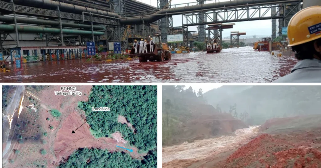
-According to media and worker testimony, on March 16, the PT Huayue Nickel Cobalt tailings storage facility was breached, and liquified tailings flowed into the Bahadopi River. The breach flooded facilities at the Indonesia Morowali Industrial Park (IMIP) and the village of Labota with a wave of red water, putting the health of workers and 341 families at risk through exposure to heavy metals. https://earthworks.org/blog/multiple-dams-fail-at-indonesian-nickel-mining-facilities/ (28 March 2025)
THE REST OF THE WORLD
Libya How extreme rainfall and failing dams unleashed the Derna flood disaster Our findings reveal that the region’s dams, even if structurally sound, would have provided minimal protection against the extreme runoff. However, their failure unleashed a destructive surge wave, amplifying the disaster’s magnitude and devastation.
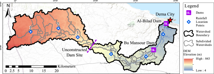
Here, we show that the collapse of aging flood control infrastructures, compounded by inadequate risk assessment and emergency preparedness, dramatically escalated the disaster’s impact. Our findings underscore the urgent need for systematic dam safety evaluations, enhanced flood forecasting, and adaptive risk management strategies that address climate extremes and infrastructure vulnerabilities. https://www.nature.com/articles/s41467-025-59261-9 (06 May 2025)
USA NYPA begins final decommissioning, stabilization of Alcoa dam To assess the recent extensive deterioration of the dam, NYPA commissioned an engineering assessment of the Alcoa Powerhouse in 2017 and decided to move forward with this work. The project includes the final decommissioning of the facility and the stabilization and capping of the remaining structure to form an earthen dam, which will support the water management system around the St. Lawrence River. Following the award of a competitively bid contract last fall, Luck Brothers of Plattsburgh, New York will be the contractor of record for the project under NYPA’s direction.
-When construction of the original powerhouse was completed in 1900 to support the manufacturing of aluminum by the Pittsburgh Reduction company, it was the largest concrete structure in the world. As demand for aluminum products grew, the company expanded and the town of Massena grew around it. The Pittsburgh Reduction Company was renamed the Aluminum Company of America and eventually in 1910, it became Alcoa. In 1958, Alcoa began to receive power from the Power Authority’s newly constructed St. Lawrence-Franklin D. Roosevelt Power Project Power Project. At that time, the Alcoa Power Dam was partially decommissioned, and power-generating equipment was removed. https://www.power-eng.com/renewables/hydropower/nypa-begins-final-decommissioning-stabilization-of-alcoa-dam/ (09 May 2025)
SANDRP
Also see: DRP 05 May 2025 & DRP 28 April 2025
Follow us on: www.facebook.com/sandrp.in; https://twitter.com/Indian_Rivers
