
(Ongoing rescue work inside Badkot-Silkyara tunnel in Uttarkashi. Image Source: HT)
In yet another disaster in the Himalayas, at least 40 workers are trapped in an under-construction tunnel being constructed by National Highways & Infrastructure Development Corporation Ltd. (NHIDCL), among others. The Hindustan Times has wrongly named the construction company as Hydroelectricity Investment & Development Company Limited (HIDCL) possibly of Nepal govt. Some people at the location have informed us that it may take another day before the workers are rescued.
NHIDCL was not even sure of the total of number of workers, as they gave the number as 36, which was corrected by the district administration later on to 40. It is also strange to see the work going on even on a Diwali day. Another disturbing aspect is that all the workers are reportedly mostly from outside Uttarakhand, when Uttarakhand villagers are known to migrate in large numbers to outside the state for employment. This disaster thus raises a lot of questions, which will need answers once the workers are rescued safely. The workers are still trapped over 30 hours after the disaster. The work at the 4.5 km long tunnel is being built under Char Dham Road Widening project since over 4 years, and violations have been happening in the work since then, as we reported in 2019.
GANGA; Uttarakhand Nearly 40 labourers trapped as under-construction tunnel collapses At least 36 workers were reportedly trapped after a portion of a tunnel under construction between Silkyara and Dandalgaon on the Brahmakhal-Yamunotri national highway in Uttarkashi district collapsed in the early hours of Sunday (Nov. 12), trapping around. Police said the incident took place around 4am when a 150-metre-long portion of the four-and-a-half-kilometer-long tunnel collapsed. https://www.hindustantimes.com/india-news/uttarakhand-labourers-feared-trapped-as-under-construction-tunnel-collapses-in-uttarkashi-101699770567332.html (12 Nov. 2023)
The rescue work is still going on for past 24 hours to save 40 workers trapped in Badkot-Silkyara tunnel collapse incident in Uttarkashi: Citing officials from the Hydroelectricity Investment and Development Company Limited (HIDCL), the contracted entity responsible for the tunnel’s construction, Yaduvanshi had initially put the number of labourers trapped in the tunnel at 36. However, the District Emergency Operation Centre later released a list of 40 labourers trapped inside. They are from Bihar, Jharkhand, Uttar Pradesh, West Bengal, Odisha, Uttarakhand and Himachal Pradesh. https://www.hindustantimes.com/india-news/uttarkashi-tunnel-collapse-40-workers-feared-trapped-rescue-ops-underway-latest-updates-101699835705859.html (13 Nov. 2023)

In this May 2019 Guest Blog, Omkar Bahuguna lists some of the gross violations of norms during construction of Dharasu band (Silkyara) tunnel in Uttarkashi. https://shorturl.at/psEFQ (03 May 2019)
HYDRO POWER PROJECTS
Sikkim In the flood’s wake, a trail of hazards lie in wait Kavita Upadhyay: –Dan Shugar, a geomorphologist from the University of Calgary in Canada, who is currently conducting research on the GLOF, noted that before the flood, the lake’s area was 1.62 sq. km, and after water being drained out in the GLOF, the area dropped to 1.46 sq. km. Adding to the existing hazard, weeks after the disaster, there have been continuous landslides along the slope that first failed on October 3, Dr. Shugar added.
– When the flood gushed through the valley, it triggered a landslide about 30 km downstream of the South Lhonak lake, which blocked the river, forming a landslide-dammed lake. After reviewing satellite images, Dr. Ashim Sattar, a mountain hazard specialist who is currently studying the GLOF and has authored research articles predicting different GLOF scenarios for the South Lhonak lake surmised that the lake had not drained even by November 1. Considering the risk of sudden release of water downstream, it requires monitoring.
– The Sikkim government has been claiming that the GLOF was triggered by a cloudburst. In fact, Sikkim State Disaster Management Authority’s daily reports on deaths and damages continue to call the flood “cloudburst induced”. The National Disaster Management Authority’s October 4 press release also called the event a “likely combination of excess rainfall and a GLOF”. However, according to G.N. Raha, who heads the Meteorological Centre in Gangtok, the possibility of either a cloudburst or extreme rainfall triggering the GLOF is very low. The 10 weather stations across North Sikkim recorded light-to-moderate rainfall for the period of the GLOF, Dr. Raha said. On the morning of October 4, the station at Lachen, almost 46 km from the South Lhonak lake, recorded only 6.7 mm rainfall for 24 hours, he said. However, scientists continue to analyse meteorological data for accurate information regarding the role of rainfall in the GLOF.
– Maximillian Van Wyk de Vries, an assistant professor of physical geography at the University of Nottingham, U.K., said that at the South Lhonak lake, a large section of the lateral moraine was “moving for many years preceding the collapse, at a rate of several metres per year”.
– On October 13, the Indian Space Research Organisation’s (ISRO) National Remote Sensing Centre published satellite images showing a large deposit of sediments and several landslides along the path of the flood, especially in and around the Chungthang dam. The loose sediment may pose a threat to downstream areas in future, said Kalachand Sain, Director of the Dehradun-based Wadia Institute of Himalayan Geology. In view of the many hydropower-related dams in the Teesta Basin, the large amount of loose sediment that can easily be eroded by heavy water flow may imply a shorter lifespan for dams and lower efficiency for hydropower projects, scientists said.
– In 1990, the South Lhonak glacier was 6.4 km long. A research article published in 2021 found that, by 2019, it had reduced by about 1.3 km and that its area had declined by about 0.96 sq. km. In 1976, the South Lhonak lake area was a mere 0.20 sq. km, according to a research article published in 2018. As the glacier shrank, the lake grew larger. By 2019, the lake was covering 1.35 sq. km, per the 2021 article. Anil V. Kulkarni, Distinguished Scientist at the Bengaluru-based Indian Institute of Science’s Divecha Centre for Climate Change, said, “The lake’s rapid expansion might have weakened the permafrost that was holding the moraines, which would have been one of the important reasons behind slope failure on October 3.” https://www.thehindu.com/sci-tech/energy-and-environment/south-lhonak-lake-flood-teesta-dam-climate/article67503729.ece (06 Nov. 2023)
Arunachal Pradesh Big dams a threat to Assam’s state bird A document prepared for the conservation of the bird species said fluctuations in flow of rivers such as the Lohit, Dibang, Siang, Subansiri and Kameng in Arunachal Pradesh would seriously impact breeding sites of the white winged duck, Assam’s state bird, in Dibru Saikhowa National Park and Nameri National Park in Assam, two major habitat of the duck. https://www.deccanherald.com/india/assam/big-dams-in-arunachal-pradesh-identified-as-a-threat-to-white-winged-duck-assams-state-bird-2759469 (07 Nov. 2023)
Subansiri Project Ignored warnings led to Subansiri running dry
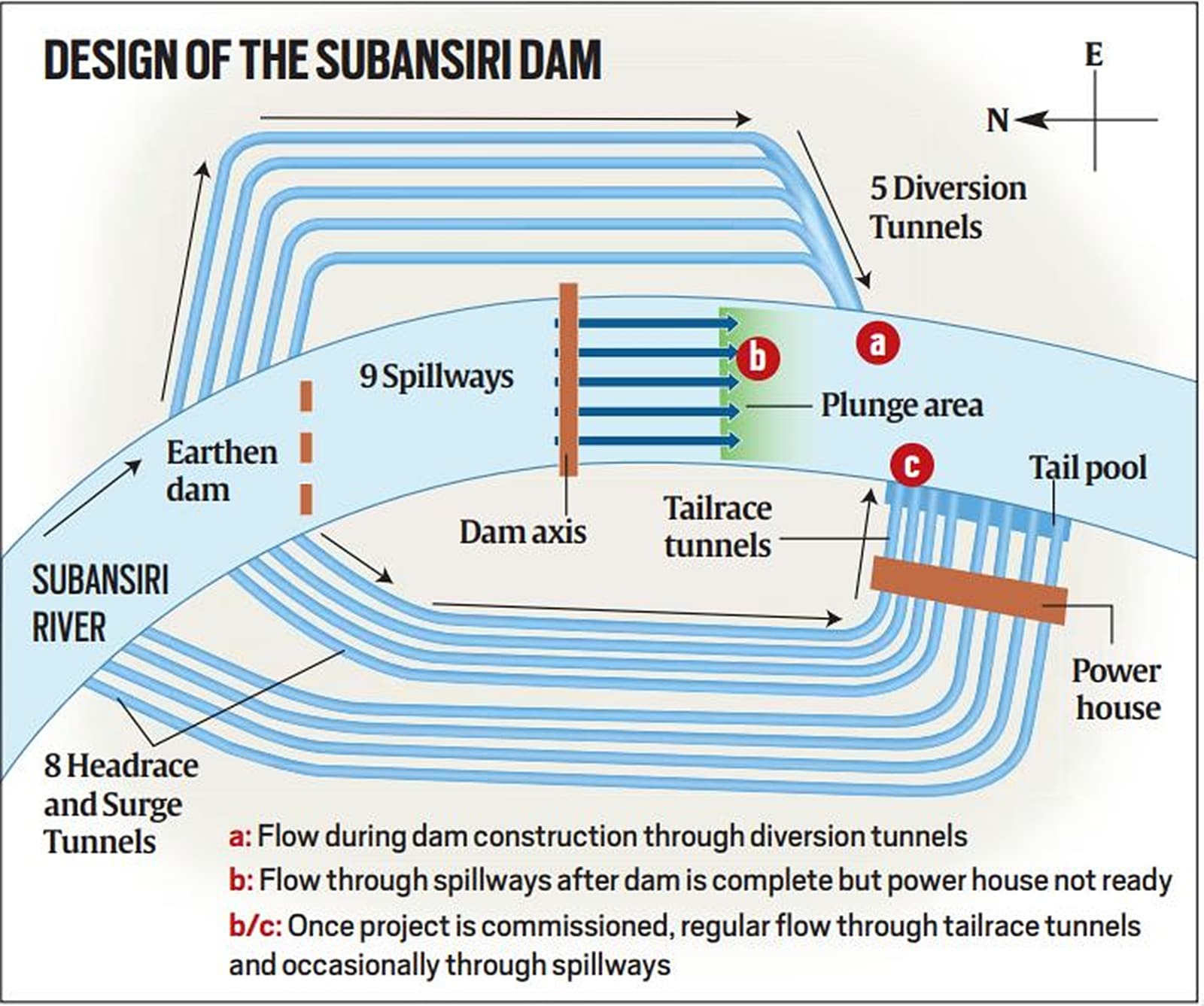
Excellent piece by Jay Mazumdar in Indian Exp Today (Nov 8 2023) on Lower Subansiri Hydro landslide. https://indianexpress.com/article/explained/how-ignored-landslide-warning-led-to-subansiri-river-running-dry-explained-9018295/ (08 Nov. 2023)
Jammu & Kashmir Facing frequent protests, contractor halts work on Ratle power project Megha Engineering, the contractor working on the 850 Ratel Hydropower project in Kistwar dist of J&K, on Chenab river, has stopped work indefinitely due to frequent stops to the work by the affected people.
The project had two inaugurations, one in 2013 and again last year by PM Modi. Earlier contractor had quit the work in 2016. Megha Engineering came into picture in 2022 with agreement with the Ratle Hydropower Corp Ltd. In Oct 2022 a landslide at the project site led to death of four persons. https://www.tribuneindia.com/news/j-k/facing-frequent-protests-contractor-halts-work-on-ratle-power-project-560445 (8 Nov 2023)
Himachal Pradesh Jammed gates of Malana dam yet to be fixed According to officials, the flood gates of 100-mw Malana-II water dam had got jammed due to large amounts of silt and boulders following a flash flood in the Malana rivulet on July 24. As the management was unable to open the gates, the dam had started overflowing, triggering fear and panic downstream and prompting Kullu administration to issue an alert.
Sources said that the management has been trying to move hydraulic machinery for removing silt without success as an approach road to the dam site was also washed away. The electricity generation at the Malana-II also remains suspended since July 24. “The dam management is now waiting for the water level in the Malana rivulet to go down before starting repair work. The work on rebuilding the approach road to the dam is also presently on. Thankfully, there was no flash flood in Malana rivulet after July, otherwise anything could have happened,” said a source. https://timesofindia.indiatimes.com/city/shimla/month-later-jammed-gates-of-malana-dam-yet-to-be-fixed/articleshow/103564953.cms (11 Sept. 2023)
MoEF Decisions of EAC meeting on River Valley Projects held on Oct 17-18 2023 from the minutes. This is the first meeting of the reconstituted EAC on RVP.
1. Ramial Left Bank Pumped Storage Project (1500 MW) by RENEW SOLAR POWER Pvt Ltd at KENDUJHAR, ODISHA For TOR: APPROVED
2. Tarali Pumping Storage Project (1500 MW) by ADANI GREEN ENERGY Ltd at SATARA,MAHARASHTRA for amendment in TOR: APPROVED
3. Hasdeo Bango Pumped Storage Hydro-electric Project (1200 MW) by CHHATTISGARH STATE POWER GENERATION COMPANY Ltd at KORBA, CHHATTISGARH for TOR: APPROVED
4. Brahmani Pumped Storage Project (600 MW) by ACME CLEANTECH SOLUTIONS Pvt Ltd at CHITTORGARH, RAJASTHAN for TOR: APPROVED
5. Vijayanagar Pump Storage Project by JSW ENERGY PSP TWO Ltd at BALLARI, KARNATAKA for EC: Approved
6. Jakhol Sankri Hydro Electric Project (44 MW) in 39.99Ha in Village & Tehsil Mori District Uttarkashi, Uttarakhand by M/s SJVN Ltd. – Reconsideration of Environmental Clearance: More Info Sought.
7. Cumulative Impact Assessment and Carrying Capacity Study (CIA & CCS) of Yamuna River Basin in Uttarakhand by Indian Council of Forestry Research and Education (ICFRE), Dehradun – Status of study report: Further studies required.
8. Cumulative Impact Assessment and Carrying Capacity Study (CIA & CCS) of Yamuna River Basin in Himachal Pradesh by Indian Council of Forestry Research and Education
(ICFRE), Dehradun – Modifications of Terms of Reference: Not accepted.
9. Cumulative Impact Assessment and Carrying Capacity Study (CIA & CCS) of Sutlej River Basin Study in Himachal Pradesh by Indian Council of Forestry Research and Education
(ICFRE), Dehradun – Reconsideration of Study Report – Accordingly, the EAC recommended the study report for acceptance by the Ministry.
10. Cumulative Impact Assessment and Carrying Capacity Study (CIA & CCS) of Tirap Basin. Inclusion of Chinglum Hydroelectric Project in Subansiri Basin – Conducting study: Ar P officials not present.
11. Proposal for conducting Cumulative Impact Assessment (CIA) & Carrying Capacity Study (CCS) of Ravi River Basin in Himachal Pradesh –Consideration of proposal: Revised TOR to be submitted.
12. Discussion on requirement of CIA/CSS for small hydro power projects: Deliberations to be continued. https://parivesh.nic.in/utildoc/22300132_1699353939812.pdf
Relevant agenda for FAC meeting to be held on Nov 14 2023: DIVERSION OF 2250.05 HA (INSTEAD OF 2272.05 HA) FOREST LAND FOR MORAND – GANJAL IRRIGATION PROJECT IN HOSHANGABAD, BETUL, HARDA AND KHANDWA DISTS OF MADHYA PRADESH’s NARMADA VALLEY DEVELOPMENT AUTHORITY https://forestsclearance.nic.in/AgendaDetail.aspx?id=293!dis1
DAMS
Kaleshwaram Project Why the residents aren’t happy In fact, on the Telangana government’s insistence that the Polavaram Project Authority (PPA) in Andhra Pradesh carry out a study on Polavaram’s backwaters in June 2023, the Maharashtra government in a letter asked Telangana to do the same for the Medigadda barrage as the backwater from Medigadda had an adverse impact on Maharashtra’s Sironcha town during the floods in 2022. Telangana villagers involved in agriculture refer to this precise ‘backwater’ issue while bringing up their disgruntlement with the barrages.
– Explaining the functioning of Kaleshwaram’s barrages, an engineer employed by the Telangana government, requesting anonymity, said that the backwater problem recurs due to poor planning. “The barrages already store water. When it rains heavily, the barrage, which hinders the free flow of water, causes it to flow into the fields. Coupled with the water flow, when the barrage gates are opened, the fields are completely submerged.”
– He also noted that the flooding was an easily avoidable problem. “When it rains in the neighbouring state of Maharashtra, it takes a few hours for it to start pouring in Telangana. If water were to be released intermittently when rains start, we can avoid this problem. In fact, estimating the flow of rain is quite simple as we have computer simulations to do it for us. However, this problem persists because at the time of conception itself the government neglected the backwater problem and was in a hurry to finish the construction,” he claimed. Around 200 farmers in Annaram staged a protest after the 2022 floods demanding compensation for crop loss. “We never get compensation.” https://www.thenewsminute.com/telangana/ground-report-safety-not-a-concern-but-residents-near-kaleshwaram-barrages-arent-happy (07 Nov. 2023)
The National Dam Safety Authority (NDSA), which inspected the Medigadda barrage after the incident came to light, has pointed to “construction deficiencies due to lack of stringent quality control” and “deficiencies in project planning and design” that led to the failure. However, several central agencies had given clearances for different aspects of the project. Dam sector experts, including serving and retired engineers and civil servants at the Centre and state who have worked in irrigation sector, told The Print that a thorough investigation is required. https://theprint.in/india/centre-blames-telangana-for-defective-kaleshwaram-project-but-central-agencies-gave-clearances-too/1838202/ (10 Nov. 223)
Polavaram Project Govt to resume work after 4 monthss Andhra Pradesh government will resume work on the Polavaram irrigation project from Monday, Nov 13 2023 after a gap of nearly four months. Dam authorities stopped work in mid-July after Godavari River witnessed floods. Water seeped into the area where project works had been going on. Water had also started oozing from the ground.
– Authorities are now dewatering an earmarked area at the Polavaram dam site using heavy duty pumps. They will take up vibrocompaction from November 13 to solidify loose sand, preparing the ground for laying the foundation for Polavaram dam. Vibrocompaction is a big task, as nearly 38 lakh cubic metres of loose sand has to be solidified. For the purpose, six rigs are being set up in a phased manner. Machinery and material are being mobilised. There is also another task of filling up scoured portions at the dam site.
– State government is yet to decide whether it should go for full-length construction of a new diaphragm wall measuring nearly 1,400 meters length, 1.5 meters width and depth ranging from maximum 80 metres to minimum 45 to 50 metres parallel to the existing wall, which got damaged, or only repair this wall damaged at four places. The second option is risky, as connecting a new wall to the existing wall at four places in a foolproof manner is a very challenging task.
– Centre has called for a meeting in New Delhi on November 16 to take a final decision on the issue of diaphragm wall. Officials from Water Resources Department, Central Water Commission and Polavaram Project Authority will participate in the meeting. https://www.deccanchronicle.com/nation/current-affairs/111123/andhra-pradesh-to-resume-work-at-polavaram-dam-from-tomorrow.html (12 Nov. 2023)
Hirakud Project WRD to execute delay-hit project The additional spillway for Hirakud Dam was proposed after the Central Water Commission (CWC) gave recommendation to enhance floodwater discharge capacity of all major dams. The state government selected Tata Projects Limited and AGE Group, Turkey to carry out work on the additional spillway at an estimated cost of Rs 369.53 crore. Work started in January 2019 but the two firms backed out of the project in February 2020 alleging delay in handing over of land for the project by the govt.
– Subsequently, a fresh tender was floated and the project estimate was revised for the second time. The Odisha Construction Corporation (OCC) Limited was selected to execute the project. However, no visible progress took place following which the Water Resources department decided to take over the project work. Chief engineer of Upper Mahanadi Basin Ananda Chandra Sahu said though OCC was selected to execute the project, the plan was dropped due to some official issues. It has now been decided that the additional spillway project work will be executed by the Water Resources department under the direct supervision of CWC. Work on the project will begin soon.
– The estimated budget of the project is Rs 786.44 crore. As per the project proposal, length of the additional spillway will be 91 metre and it will have five sluice gates. The channel’s width will be 300 metre and length 1.9 km. The spillway channel will originate from near Gandhi Minar on the left dyke of the dam and meet Mahanadi river near Jawahar Udyan.
– Currently, there are 98 gates in Hirakud dam to release 15 lakh cusec water. After the construction of the additional spillway, which is a World Bank-funded project, the water discharge capacity of Hirakud dam will increase to 18 lakh cusecs. https://www.newindianexpress.com/states/odisha/2023/nov/11/water-resources-dept-to-execute-delay-hit-project-2632131.html (11 Nov. 2023)
Madhya Pradesh Sufferings of Karam Dam PAFs There is no power or water supply in the forested area, but people have settled here as the compensation they got is not enough to buy new plots. https://www.newsclick.in/mp-displaced-karam-dam-residents-9-villages-isolated-hillock-dhar-district (09 Nov. 2023)
INTERLINKING OF RIVERS
Godavari-Cauvery Linking Centre to sign MoU with 7 states Telangana objects The Central government decided to sign a memorandum of understanding (MoU) on the Godavari-Cauvery link project before January, 2024. The meeting of the ‘Task Force on Interlinking of Rivers’ (TF-ILR) was held at Jala Soudha in Hyderabad on Friday (Nov 10 2023) and details about various projects, including the ‘Godavari-Krishna-Pennar-Cauvery’ link project were discussed. Sriram Vedire, chairman of the TF-ILR, chaired the meeting which saw the attendance of Central Water Commission chairman, director general of National Water Development Agency, officials from Andhra Pradesh, Telangana, Tamil Nadu, Karnataka, Chhattisgarh, Rajasthan and Madhya Pradesh and experts from the task force.
According to sources, the final copy of MoU would be circulated to states by December end and an agreement would be signed by January 15, 2024. The chief ministers of respective states have to sign the MoU. The MoU would be signed once the elections in Telangana are completed, sources added. Telangana Irrigation engineer-in-chief C Muralidhar opposed the proposal to use Icchampally for diverting Godavari water.He suggested the Centre use Sammakka-Sarakka (Tupakulagudem) barrage for the same. https://www.newindianexpress.com/states/telangana/2023/nov/11/centre-to-sign-mou-on-godavari-cauvery-link-project-seven-states-give-nod-2631989.html (11 Nov. 2023)
The Task force headed by Vedire Sriram had also assured that surplus waters from Godavari would not be utilised for diversion to Cauvery. He explained that only unutilised quantum of Chattisgarh would be diverted to Cauvery via Inchampalli (Telangana), Nagarjuna Sagar and Somasila Project (AP). This project envisages diversion of 4189 MCM from Godavari to Cauvery with enroute utilization and with the introduction of micro irrigation system to improve the water use efficiency.
*This link proposes to provide about 1250 MCM each to the states of AP and Telangana, about 1150 MCM to Tamil Nadu and about 450 MCM to Karnataka.
*Taskforce assured that allocated waters of any state would not be touched for utilization under this project.
*This river link would not use the surplus waters in river Godavari, as there are no surplus waters in the river as per the studies conducted by CWC. https://timesofindia.indiatimes.com/city/vijayawada/andhra-pradesh-agrees-to-godavari-krishna-pennar-cauvery-link/articleshow/105132292.cms (10 Nov. 2023)
Ken-Betwa Linking A threat on Panna Tiger reserve Environmentalists have said that the project will submerge 40% of the Panna tiger reserve, home to the several species of critically endangered vultures, the gharial and other species such as leopards and sloth bears. Of the total 9,000 hectares to be submerged, 6,000 hectares are part of the tiger reserve. “Panna will lose its best forest to Ken-Betwa and survival of tigers in remaining area will be difficult,” said a retired Indian Forest Service official of Madhya Pradesh cadre, who asked not to be named. The MP forest department has proposed providing additional land for the Panna tiger reserve but the official quoted above said it will take decades to develop a forest there.
Joanna Van Gruisen, whose husband Raghu Chandawat worked on the revival of tiger population in Panna from next to nothing in 2008 to 41 currently, said the project will spell doom for both Panna and Bundelkhand. “The drying Ken river will not help Bundelkhand in any way. Thousands of small water bodies and rivulets will be lost for ever. 40% of Panna tiger reserve will be under water. Tigers and other wildlife will lose their home permanently. It is a colossal waste of money.” https://www.hindustantimes.com/india-news/madhya-pradesh-election-ken-betwa-river-project-looms-over-poll-arena-101699381891653.html (8 Nov 2023)
INTERSTATE WATER DISPUTES
Cauvery Water Disputes Hi-Tech monitoring system for precise water data A state-of-the-art Telemetric Water Monitoring System, equipped with velocity and level sensors, has been installed on a bridge across the Cauvery River at Koppa-Kushalnagar on the Kodagu-Mysuru border. This sensor-based monitoring system offers automated and real-time data 24×7, providing precise information regarding the river’s inflow, water level & velocity.
The installation has been carried out by the Water Resources Development Organisation, a Central Gov agency operating under the National Hydrology Project. This organisation has an Irrigation Investigation Sub-Division Office in Mysuru that is overseeing the implementation of this sensor-based water monitoring system. Each system costs Rs. 30 lakh and is imported. A similar system has already been deployed at Bannur, where the Cauvery River flows and approvals are pending for installing two more systems on Lakshmanatheertha River (near Hunsur) & Lokapavani River in Mandya (a tributary of Cauvery).
This system provides real-time data every 15 minutes to over 15 agencies in Karnataka and at the national level, including the India Meteorological Department, Cauvery Neeravari Nigam Limited and the Karnataka State Natural Disaster Monitoring Centre. Additionally, the data can be utilised by regulatory authorities such as the Cauvery Water Monitoring Authority (CWMA) and the Cauvery Water Regulation Committee (CWRC) to determine the water allocation between the Southern States.
The system operates using solar energy and has been installed by Sun Technologies, Chennai, which is responsible for data transmission, system installation and maintenance for five years. A Telemetric Water Gauge has already been installed at the Krishna Raja Sagar (KRS) Dam in Mandya district and at Harangi Dam in Kodagu to provide sensor-based real-time data on reservoir storage levels, inflow and outflow. These installations are part of an Online Monitoring System for the Cauvery Basin, utilising Telemetry-based Real-time Data Acquisition and Transmission. https://starofmysore.com/hi-tech-monitoring-system-for-precise-cauvery-water-data/ (08 Nov. 2023)
The rainfall witnessed last week by parts of south interior Karnataka (SIK), including certain areas of Bengaluru, came handy for Tamil Nadu to realise nearly two-thirds of the Cauvery water, as stipulated by the Cauvery Water Management Authority (CWMA) for the period ending up to November 23.
Up to November 9, the realisation, as recorded at Biligundulu, was 3.29 thousand million cubic feet (tmc ft) against the prescribed quantity of 5.17 tmc ft for 23 days of November. This could be attributed to the SIK region recording a deviation of 136% in rainfall during the week that ended November 8. Between June 1 and November 9, the State received 61.3 tmc ft. https://www.thehindu.com/news/national/tamil-nadu/tamil-nadu-realises-nearly-two-thirds-of-cauvery-water-stipulated-by-cwma/article67524377.ece (11 Nov. 2023)
IRRIGATION
ICID discusses irrigation water augmentation The three-day 25th ICID (international commission on irrigation and drainage) Congress, which witnessed the participation of AP chief minister YS Jagan Mohan Reddy and Union jal shakti minister Gajendra Singh Shekhawat, concluded in Visakhapatnam. This Congress brought together a global congregation of around 1,300 experts, researchers, and professionals. https://timesofindia.indiatimes.com/city/visakhapatnam/icid-discusses-irrigation-water-augmentation/articleshow/104997423.cms (06 Nov. 2023)
Maharashtra Activists demand that Fadnavis resign, call him mute spectator Even though the command area development authority of the Godavari Marathwada Irrigation Development Corp (GMIDC) issued an order for the release of 8.6 TMC water from upstream areas of the Jayakwadi dam on October 30, the water was not released. Kisan Sabha leader Rajan Kshirsagar said it is the first time that the water release for the Jayakwadi dam has not taken place despite an official order being issued. “Instead of prevailing upon the authorities to release the water, the WRD minister Devendra Fadnavis has chosen to remain mute. He must resign,” he said. https://timesofindia.indiatimes.com/city/aurangabad/activists-demand-that-fadnavis-resign-call-him-mute-spectator/articleshow/105055407.cms (8 Nov 2023)
URBAN RIVERS
Mula-Mutha; Pune Debunking PMC’s Misleading Claims about the RFD Project in Pune ell-known environmental authority Sarang Yadwadkar exposes misleading claims and inaccurate statements made by the PMC about the River Front Development project. Viewers are presented with evidence that contradicts and refutes certain assertions that were presented as facts.
The goal is to set the record straight by providing objective evidence and analysis that challenges questionable or unfounded positions. Overall, the content aims to have an honest, fact-based discussion and give visibility to multiple perspectives on this issue. https://www.youtube.com/watch?v=rltLv_r0-eE (07 Nov. 2023)
Sabarmati; Ahmedabad Inspection of STPs ordered The Gujarat high court on Friday (Nov. 10) asked the SPCB to inspect the STPs to see if they are properly functional. This happened after amicus curiae Hemang Shah pointed out that the STPs were malfunctioning. The bench of Chief Justice Sunita Agarwal and Justice V D Nanavati said that the STPs were not up to the mark. “So according to us, they are not working. This is kind of befooling yourself that they are working. Only 4 are working, 6 are not up to the standard,” the CJ said, when the court was apprised about the functioning of 10 STPs that are in AMC limits. The amicus curiae also pointed out to an industrial unit illegally discharging effluent in the MEGA pipeline despite having a zero-liquid discharge status. He demanded registration of an FIR. https://timesofindia.indiatimes.com/city/ahmedabad/river-pollution-inspection-of-stps-ordered/articleshow/105136478.cms (11 Nov. 2023)
Gomti; Lucknow Govt to deploy ecological task force The Gomti., a tributary of Ganga, will have its own ecological task force (ETF) of the Territorial Army for its protection and rejuvenation. A letter in this regard was written to the DM by SP Vashishth, executive director, NMCG. In his letter the executive director said that the NMCG has decided to deploy one company of ETF in Lucknow for the rejuvenation of the Gomti. Vashishth requested the DM to ensure a meeting of commanding officer of the Ganga task force with officers of the agriculture and horticulture department. jal nigam, public works development., UP pollution control board and the forest department. https://timesofindia.indiatimes.com/city/lucknow/gomti-to-have-an-ecological-task-force/articleshow/105138679.cms (11 Nov. 2023)
RIVERS
Yettinahole Project Cost increased to Rs. 23,0000 crore Speaking after inaugurating Yaragol dam in Yaragol village of Bangarpet taluk on Saturday (Nov. 11), the CM said that water could have been supplied from the project by this time if the works were carried out in the last five years. Yaragol dam supplies water to Kolar, Bangarpet, Malur and 45 villages in the region. “It is being alleged that all the money is being diverted to guarantees and no development work is being taken by the government. Today, we have launched works worth Rs 2,263 crore. The outlay for Yettinahaole project has been increased to Rs 23,000 crore,” Siddaramaiah said. The CM said that 965 acres of land have been taken back from Beml in Kolar Gold Fields and a new industrial township will come on the said land. https://www.deccanherald.com/india/karnataka/we-will-complete-yettinahole-and-supply-water-siddaramaiah-2767362 (12 Nov. 2023)
Rajasthan Farmers seek to stop river water pollution by industries Residents of Jaitpur and Gadhwara said no farming activities have taken place on land in a radius of 5 km to 7 km of the twin villages for the last 40 years. The extremely high presence of toxins in the underground water has made several bighas of the agriculture land barren. If anyone in the region is still involved in agriculture, they are completely dependent on rainwater for irrigation, said the farmers. “The problem is that we have never had an MLA who comes from a farming background. Elected representatives from farming backgrounds can understand what we have gone through. At present, it is the industries’ money power that rules the area. No one thinks about us farmers,” said Lakshman Patel, 70, a former sarpanch of Gadhwara village.
He lamented the fate of the land. “Even grass does not grow in these villages. The soil has been corroded to irreparable extents. Our next generations are compelled to work as labourers in the same factories that polluted our lands,” said Patel. When people from nearby villagers take their farm produce to sell in the market, they are asked if the crop was cultivated using rainwater or Bandi River water. Farm produce grown by irrigation with the Bandi River water has no buyers, said villagers.
“All systems are in place to treat polluted water of the industries before it is released into the Bandi River, but the polluted water continues being released untreated for decades. The Bandi can hardly be called a river today. We have raised the matter before NGT, the high court, and Supreme Court of India, but are still awaiting justice,” said Gautam Trivedi, a member of Kisan Paryavaran Sangharsh Samiti, an organisation that raised the matter with NGT. https://timesofindia.indiatimes.com/city/jaipur/as-fertile-fields-lie-barren-for-40-years-farmers-seek-to-stop-river-water-pollution-by-industries/articleshow/104932650.cms (03 Nov. 2023)
NARMADA Some information on corruption in plantation work along Narmada river under Rs. 535 crore Namami Narmada Project and how river has been suffering from lack of flows, increasing pollution and sand mining activities. https://epaper.subahsavere.news/clip/8089 (08 Nov. 2023)
27 Mussoorie hotels ordered to shut down over pollution In a strict and unprecedented crackdown, the SPCB on Wednesday (Nov. 08) issued notices to 27 hotels – some of them luxurious and prominent – in Mussoorie, ordering them to shut down their properties with immediate effect.
The move to crack down on hotels has come after the NGT pulled up UPCB for failing to take action against hotels drawing excess water from the springs in Mussoorie, or those whose sewage disposal was not adequate. In an “action taken report” submitted to the NGT on November 6, UPCB said it had monitored 282 hotels/ homestays and found 215 of them had valid consolidated consent and authorization . Show cause notices have now also been issued to two premier hotels in the town – Welcom Hotel Savoy and Jaypee Residency Manor – in which a fine of Rs 50 lakh on Savoy and Rs 10 lakh on Jaypee has been slapped as compensation “for causing damage to the environment”. UPCB has also written to the power corporation to cut electric supply to these properties. https://timesofindia.indiatimes.com/city/dehradun/27-mussoorie-hotels-ordered-to-close-for-flouting-green-norms/articleshow/105081855.cms (09 Nov. 2023)
हरिद्वार में नियमों को ताक पर रख गंगा के पास काटे जा रहे प्लॉट एनजीटी ने 7 नवंबर 2023 को हरिद्वार में ‘निजी गंगा घाटों’ के साथ आवासीय भूखंडों के निर्माण को गंभीरता से लेते हुए पर्यावरण, वन और जलवायु परिवर्तन मंत्रालय के सचिव सहित अन्य अधिकारियों को नोटिस जारी करने का निर्देश दिया है। कोर्ट के निर्देशानुसार इस मामले में केंद्रीय प्रदूषण नियंत्रण बोर्ड, उत्तराखंड पर्यावरण संरक्षण एवं प्रदूषण नियंत्रण बोर्ड, राष्ट्रीय स्वच्छ गंगा मिशन, हरिद्वार के जिला मजिस्ट्रेट और गंगा हेरिटेज, परियोजना प्रस्तावक को भी नोटिस जारी किए जाएंगें। इस मामले में एनजीटी ने हरिद्वार के जिला मजिस्ट्रेट को 22 जनवरी, 2024 से पहले साइट का निरीक्षण करने और उसपर स्थिति रिपोर्ट दाखिल करने का भी निर्देश दिया है।
बता दें कि 27 अप्रैल, 2023 और 30 अक्टूबर, 2023 को गंगा हेरिटेज ने अपने विज्ञापन में एनएच 34 पर निजी घाटों के साथ आवासीय भूखंडों का जिक्र किया था। जो अमात्रा रिसोर्ट से केवल 5 मिनट की ड्राइव पर है। आदेश में इस बात का भी जिक्र किया गया है कि इन आवासीय प्लॉटों को पर्यावरण नियमों का ताक पर रख उचित अनुमति के बिना काटा जा रहा है। https://www.downtoearth.org.in/hindistory/river/ganga/environment-in-court-09-nov-2023-92739 (10 Nov. 2023)
YAMUNA Delhi Toxic foam coats sacred river A thick layer of toxic foam has once again coated parts of a sacred river near New Delhi as the Indian capital battles an acrid and noxious smog that has settled across the city. For decades, sections of the Yamuna have been plagued by the dumping of toxic chemicals and untreated sewage. In several sections, the river appears dark and sludgy, while plastic waste lines its banks. This week, the toxic foam in New Delhi was joined by a throat-searing blanket of smog that prompted many panicked residents to buy air purifiers and wear face masks to minimize exposure to the fumes. https://edition.cnn.com/2023/11/09/india/india-delhi-toxic-foam-pollution-yamuna-intl-hnk/index.html (09 Nov. 2023)
The Delhi high court on Wednesday (Nov. 08) refused to entertain a plea against the ban of celebrating Chhath Puja on the banks of river Yamuna, stressing that the restrictions in place are to prevent pollution in the river. Chhath Puja Sangharsh Samiti in its plea challenged the Delhi Disaster Management Authority (DDMA) notification dated 29 October 2021 that barred from designating a site for the festival on the banks of Yamuna. The Delhi government said that the ban was imposed due to water pollution caused on the banks of Yamuna. https://www.hindustantimes.com/cities/delhi-news/delhi-hc-dismisses-plea-challenging-chhath-puja-ban-in-national-capital-101699432951860.html (08 Nov. 2023)
NCR Demarcate Yamuna, Hindon floodplains by Jan 10: NGT to DMs The NGT while hearing a petition alleging the rapid disappearance of Hindon floodplains due to unchecked illegal construction and encroachments, noted that the exercise for demarcation of floodplains of Yamuna and Hindon rivers was pending. The report stated the area between the bund and the river is a floodplain zone, which has to be identified and demarcated.
The tribunal was hearing a plea by social activist from Ghaziabad, Alok Kumar, alleging that the master plan for development of the city shows the banks of Hindon as “river protected area” but the ground reality remains different. The petition was filed on September 11. On September 26, NGT asked the state and central governments, pollution boards and the civic authorities of Noida, Greater Noida and Ghaziabad to respond to the petition.
The Noida district magistrate submitted a report on October 31, taking a note of which, the NGT said that the demarcation process of floodplain zone of Yamuna and Hindon has not been carried out. The next hearing date is scheduled for January 16. https://timesofindia.indiatimes.com/city/ghaziabad/demarcate-yamuna-hindon-floodplains-by-jan-10-ngt-to-dms/articleshow/105053940.cms (08 Nov. 2023)
Agra River of Sorrow One of the holiest rivers of India, the Yamuna in Agra has not received the focused attention of the Yogi Adityanath government in UP. Demands for desilting, dredging and cleaning up the river bed plus continuous discharge of a minimum quantity of fresh water to keep the river alive have not drawn sympathetic response from the government, say the green activists of the River Connect Campaign. https://www.siasat.com/has-yamuna-become-indias-river-of-sorrow-2714832/ (07 Oct. 2023)
SAND MINING
Tamil Nadu Ex-army man, VAO attacked An ex-army officer who videotaped illegal sand mining in Ponneri River in Vellore was allegedly attacked with a sickle by the sand mafia on Oct. 27. The victim identified as Umapathy was critically injured in the attack, and is undergoing treatment at the district government hospital.
In a similar incident, the sand thieves also attacked a village administrative officer (VAO) who went to stop the illegal sand smuggling in the Kalaiyarkovil area of Sivagangai district on Oct 27. He was attacked by the sand mafia when he visited the Annavaram & Pudupatti areas under his jurisdiction following a complaint of mysterious persons excavating gravel soil. https://www.news9live.com/crime/sand-mafia-terror-in-tamil-nadu-ex-army-man-village-official-attacked-in-separate-incidents-in-vellore-sivaganga-districts-2339922 (03 Nov. 2023)
Maharashtra HC asks police to use CCTVs The Bombay High Court has directed the police to use drone surveillance to prevent illegal sand mining in Palghar near Mumbai noting that enough steps were not being taken to curb the menace. The court has also asked police to set up watchtowers near two railway bridges at Mandvi and Saphale. The measures taken are to be supervised by senior officers of each department. The order was passed by a division bench of Justices Nitin Jamdar and Manjusha Deshpande while hearing a 2014 PIL filed by Julie Kharbhmi Labharthi Sekhari Sanstha Maryadit seeking curbing of illegal excavation of sand around Julie Island near Vaitrana Creek in Palghar. https://www.freepressjournal.in/mumbai/bombay-hc-asks-police-to-use-cctv-cameras-to-stop-illegal-sand-mining-in-palghar (07 Nov. 2023)
Rajasthan The Print’s Jyoti Yadav brings this ground report from Rajasthan, on the sand mafia nexus, and how it is fueling corruption.
https://www.youtube.com/watch?v=hQ2E2JMsiw0 (08 Nov. 2023)
Bihar Bridge collapses over Barnar, finger at sand mining A bridge over the Barnar river in Bihar’s Jamui district collapsed late on Friday (Sept. 22) night, depriving vast areas of road connectivity and once again putting a question mark on the quality of infrastructure in the state. Heavy rain has lashed the state over the past two days. The bridge that got damaged was constructed in 2009. At least eight of its pillars gave way as the water level and flow increased in the river.
Several local people blamed illegal sand mining close to the bridge and lack of proper maintenance for the mishap. “The bridge was like a lifeline for the area. It had withstood heavier rains and water flow in the river since its construction. But of late, illegal mining sand close to the structure. Another reason is lack of proper inspection and repairs by the government,” Dharmendra Chaudhary, a resident told reporters. Another resident Mukesh Shastri said that the “people in the area had opposed sand mining close to the pillars of the bridge several time. In turn, they were implicated in false cases”. https://www.telegraphindia.com/india/bihar-bridge-collapses-over-barnar-river-finger-at-sand-mining/cid/1968506 (24 Sept. 2023)
WETLANDS, LAKES, WATERBODIES
Tamil Nadu SWA orders action against encroachment in Udhagamandalam wetland It seeks a report on wetland encroachment in the district following construction activities near the railway station and other facilities close to Ooty lake. The State Wetland Authority (TNSWA) has ordered the Nilgiris authorities to file a report on wetland encroachment in the district following construction activities near the Udhagamandalam railway station and other facilities close to the Ooty lake. https://www.thehindu.com/news/national/tamil-nadu/state-wetland-authority-orders-action-against-encroachment-in-udhagamandalam-wetland/article67489477.ece (03 Nov. 2023 )
GROUNDWATER
Punjab NGT notice to govt over water pollution Expressing concern over the findings of a study conducted by Indian Institute of Technology (IIT), Mandi, which uncovered water pollution in Punjab due to agricultural runoff, the National Green Tribunal (NGT) has issued notices to different departments of Punjab — Punjab Pollution Control Board (PPCB), departments of water supply and sanitation and agriculture and farmers welfare. The Central Pollution Control Board and IIT-Mandi have also been impleaded parties in the case.
The PPCB has been directed to file a report in response to facts disclosed in the study, including the issue of heavy metals, radioactive substances, pesticides and chemical pollutants found in the groundwater of the concerned area in sample testing within six weeks.
The tribunal had taken suo motu notice of a TOI news report ‘Agricultural Runoff Causing Groundwater Pollution in Punjab, Making Drinking Water Unsafe, Reveals Study’. The study highlighted an increase in demand for groundwater, local farmers exploiting groundwater from deeper geological strata which have heavy metals and a few are radioactive, having serious health impacts. Such incidents relating to the decline in water quality are mainly in the southwestern region of Punjab.
The PPCB sought time to examine the report and file its reply before the tribunal. It was noted that the board is actively monitoring groundwater quality at 46 different locations. However, the tribunal observed that while the PPCB claims to be monitoring groundwater quality at various locations, they were unable to provide the current water quality status. The case is scheduled for its next hearing on January 18, 2024. https://timesofindia.indiatimes.com/city/chandigarh/ngt-notice-to-punjab-over-water-pollution/articleshow/105055290.cms (08 Nov.2023)
URBAN WATER
Bengaluru KC Valley Project: Monitoring lapses, data gaps raise doubts Researchers at Paani.Earth have documented firsthand evidence exposing the inadequate wastewater treatment in five Bengaluru STPs. This untreated water is making its way to drought-prone areas in Kolar and Chikkaballapura. https://bengaluru.citizenmatters.in/kc-valley-project-paani-earth-bwssb-kspcb-iisc-130558 (08 Nov. 2023)
Lack of rainwater inlets in Thalaghattapura Lake, deteriorating water quality Residents and dedicated lake activists in Bengaluru are calling on the municipal body, Bruhat Bengaluru Mahanagara Palike (BBMP), to create inlets for the natural flow of rainwater into Thalaghattapura Lake. Raghavendra Pachhapur, a lake activist, told Bangalore Mirror that the lake has two inlets for the entry of water. However, the BBMP has raised a wall to close off the entry of sewage into the lake. While this has helped stop the water from being contaminated, it has resulted in the blocking of rainwater from entering the lake. https://bangaloremirror.indiatimes.com/bangalore/civic/drowning-in-dilemma/articleshow/105048747.cms (08 Nov. 2023) c
Encroachment mapped: Leave rajakaluves alone After complaints from local residents regarding encroachment of rajakaluves by various properties, the tahsildar office, Bengaluru East taluk, Krishnarajpura, has called upon the sub tahsildar and revenue officials to investigate the claims, prepare a map and submit a report. The encroachments were alleged in Varthur Hobbali, Doddakannelli, Chikkanahalli, Hadosiddapura, Chikkanayakahalli, Halanayakanahalli. The residents had filed an RTI last year, and they got the report on the number of encroachments on rajakaluves in these areas. https://bangaloremirror.indiatimes.com/bangalore/others/encroachment-mapped-leave-rajakaluves-alone/articleshow/105077329.cms (09 Nov. 2023)
Tussle over custody of Nagawara, Hebbal lakes The BBMP has refused to take custody of two prominent lakes from the forest department after the civic body found that some parts of Hebbal and Nagawara lakes are registered under private individuals. The revenue department is not correcting the land records (RTC) of both these lakes despite issuing multiple reminders, officials from both the BBMP and the forest department said. https://www.deccanherald.com/india/karnataka/bengaluru/tussle-over-custody-of-nagawara-hebbal-lakes-as-records-not-in-order-2764901 (10 Nov. 2023)
No road on Bellandur Lake, only canal, bund: BDA The Bangalore Development Authority (BDA) on Wednesday (Nov. 08) filed an affidavit with the NGT in Chennai stating that it has not built any road through Bellandur Lake. This was in response to a complaint filed with the Tribunal by a resident, Harikrishna, accusing the authority of building a road through the lake.
A top official said, “We filed an affidavit today (Wednesday) stating that BDA has never built a road through the lake. The BDA had only built a diversion canal as well as a bund in order to divert sewage downstream so that it does not enter the lake. It has been erroneously reported to the Tribunal by the owner of a local school that a road had been built by us.” https://www.newindianexpress.com/states/karnataka/2023/nov/09/no-road-on-bellandur-lake-only-canal-bund-bangalore-development-authority-to-ngt-2631484.html (09 Nov. 2023)
Hyderabad A road and a park to come up in FTL area of Durgam Cheruvu Initially estimated to have spread across 160 acre valley in the hilly region, the lake is now reduced to 84 acres. The cable-stayed bridge occupied it further. The fresh attempts at filling up and road laying will only add to the violations already in place, but they have official sanction.
Though belonging to two private persons, the five-acre site reportedly is being negotiated for by Greater Hyderabad Municipal Corporation, to create a park. Officials under the condition of anonymity informed that a case is pending in the court against attempts by the government to lay the road through it. If negotiations out of the court yield result, a park will be developed in the area, right in the FTL area of the lake.
The corporate entity which has been handed over the ‘development’ of the Durgam Cheruvu as tourist destination under the corporate social responsibility initiative, will also develop the park, sources informed. https://www.thehindu.com/news/national/telangana/a-road-and-a-park-to-come-up-in-ftl-area-of-durgam-cheruvu/article67513599.ece (09 Nov. 2023)
Ahmedabad AMC to stop GW use by industry in 2 yrs Ahmedabad Municipal Corporation (AMC) has announced its plans to supply treated water to industrial units in the city in two years. This was resolved at a meeting on Nov. 07 between representatives of the AMC, the SPCB and three major industrial associations in Ahmedabad city. To this end, AMC will set up a 180 MLD tertiary treatment plant at Pirana in two years and lay a pipeline network to supply its treated water to industrial units.
Representatives of three industrial associations in the city will sign an MoU with the AMC in this regard. Charges for use of this treated water will be fixed in the coming days. “A policy in this regard is being formulated by the state government,” said a senior AMC official. An AMC official, on condition of anonymity, said, “A total of 1,320 MLD of sewage water is treated every day in Ahmedabad city. Of this, 350 to 400 MLD is released into the Fatehwadi canal and the rest is released into the Sabarmati. At present, industrial units are provided 10 MLD of treated sewage water, according to the existing policy. https://timesofindia.indiatimes.com/city/ahmedabad/corporation-to-stop-groundwater-use-by-industry-in-2-years-supply-treated-water/articleshow/105053266.cms (08 Nov. 2023)
Gurugram Canal breach fixed, but city faces water shortage Parts of the city are still reeling under a water crisis, three days after a breach was detected in the Gurgaon Water Supply (GWS) canal that supplies water to the Basai treatment plant. According to a GMDA official, soil erosion near Chandu Budhera village led to the breach on Tuesday (Nov. 07) morning. The metropolitan authority has been rationing supply as there is a shortfall of 20% in raw water from the canal due to the breach. Officials are now hoping supply will be normalised by Saturday (Nov 17). https://timesofindia.indiatimes.com/city/gurgaon/canal-breach-fixed-but-city-faces-water-shortage/articleshow/105137517.cms (11 Nov. 2023)
Delhi Govt to try out artificial rain over pollution woes Environment Minister Gopal Rai meets with experts regarding cloud seeding; report from IIT Kanpur to be submitted to Supreme Court seeking approval; cloudy days expected on November 20, 21. https://www.thehindu.com/news/cities/Delhi/delhi-proposes-to-induce-artificial-rains-to-tackle-rising-pollution/article67513937.ece (09 Nov. 2023)
WATER
Centre Women introduced to water governance The central government has launched a campaign to involve women in water governance. They will be given first-hand knowledge about the water treatment processes. The programme, ‘Women for Water, Water for Women’, is an initiative of the Union Urban Affairs Ministry under its flagship scheme – AMRUT, in partnership with the National Urban Livelihood Mission (NULM) and Odisha Urban Academy. https://www.thehindu.com/news/national/women-introduced-to-water-governance-via-central-project/article67513462.ece (09 Nov. 2023)
MONSOON 2023
SANDRP Blog High Rainfall days in India’s districts in SW Monsoon 2023 An analysis of the daily district wise rainfall data from India Meteorological Department (IMD) for India’s South West Monsoon 2023 shows that there were 2176 instances when a district rainfall of a day was above 50 mm. Such high rainfall instances included 1759 instances when rainfall was 50-100 mm, 329 instances when it was 100-150 mm, 64 times it was 150-200 mm and 24 times above 200 mm. Out of 717 districts of India, 531 districts or, about 74% of the districts experienced such high rainfall days during SW monsoon 2023. https://sandrp.in/2023/11/10/high-rainfall-days-in-indias-districts-in-sw-monsoon-2023/ (10 Nov. 2023)
FLOOD 2023
Study Flood generation: process patterns from the raindrop to the ocean Abstract: -This article reviews river flood generation processes and flow paths across space scales. The scale steps include the pore, profile, hillslope, catchment, regional and continental scales, representing a scale range of a total of 10 orders of magnitude. Although the processes differ between the scales, there are notable similarities. At all scales, there are media patterns that control the flow of water and are themselves influenced by the flow of water. The processes are therefore not spatially random (as in thermodynamics) but organized, and preferential flow is the rule rather than the exception. Hydrological connectivity, i.e. the presence of coherent flow paths, is an essential characteristic at all scales.
There are similar controls on water flow and thus on flood generation at all scales but with different relative magnitudes. Processes at lower scales affect flood generation at larger scales, not simply as a multiple repetition of pore-scale processes but through interactions which cause emergent behaviour of process patterns. For this reason, when modelling these processes, the scale transitions need to be simplified in a way that reflects the relevant structures (e.g. connectivity) and boundary conditions (e.g. groundwater table) at each scale. In conclusion, it is argued that upscaling as the mere multiple application of small-scale process descriptions will not capture the larger-scale patterns of flood generation. Instead, there is a need to learn from observed patterns of flood generation processes at all spatial scales. https://hess.copernicus.org/articles/26/2469/2022/ (12 May 2023)
URBAN FLOODS
Madurai Schools shut, rivers overflow; farmers fear crop loss As the Vaigai dam level crossed 69.8 feet on Thursday (Nov. 9) morning, the water resource department released all surplus water into the river, causing it to overflow from bank to bank throughout Thursday. The sudden surge dispersed the water hyacinth that had blocked the check dams in the Vaigai. The WRD, which had issued a third flood warning on Wednesday (Nov. 08), cautioned residents along the riverbanks in Madurai, Dindigul, Theni, Sivaganga, and Ramanathapuram districts to refrain from bathing, washing cattle in the river, or attempting to cross it. https://timesofindia.indiatimes.com/city/madurai/rain-in-madurai-schools-shut-rivers-overflow-farmers-fear-crop-loss/articleshow/105109900.cms (10 Nov. 2023)
Erode Drains blocked, 50 houses flooded Rainwater entered more than 50 houses near Gobichettipalayam and farmlands following heavy rain on Tuesday night. According to the Met Department, the Erode district received 460.80 mm of rainfall till Wednesday morning. Rainwater entered houses in Thalakkombu Pudur in Gobichettipalayam on Tuesday night. People came out of their houses and stayed on the road as the water reached a height of about 2 feet. The revenue department and the police rushed to the spot after receiving information. https://www.newindianexpress.com/states/tamil-nadu/2023/nov/09/drains-blocked-50-houses-flooded-in-tamil-nadus-erode-2631406.html (09 Oct. 2023)
Coimbatore Bridge collapses, water enters houses Heavy rain lashed Coimbatore in the intervening night of Wednesday (Nov. 08) and Thursday (Nov. 09), bringing copious flow of water into several tanks and channels. Rainwater entered around 50 houses at Vellakinar and a bridge collapsed near Vadavalli. The rain also brought down 75 trees across the city.
The 23 rainfall stations in Coimbatore district registered a total rainfall of 879.2 mm during the 24 hours that ended at 8 a.m. on November 9, 2023. Periyanaickenpalayam, TNAU, Thondamuthur, and Mettupalayam were among the areas that received high rainfall. https://www.thehindu.com/news/cities/Coimbatore/bridge-collapses-water-enters-houses-as-heavy-rain-lashes-coimbatore/article67517261.ece (09 Nov. 2023)
Bengaluru Lake breach after rain causes mayhem BBMP officials said that water overflowed from two lakes – Hebbal and Chowdeshwari in Kogilu. Due to its proximity to the major Hebbal Junction, water from Hebbal Lake impacted traffic movement the most as water stagnated on parts of the service road and the eponymous flyover. Nearly 50 homes on the first, second and third crossroads of Sahakar Nagar flooded due to the rains. The area, considered to be low-lying, saw a backflow of rainwater as the connecting stormwater drain was overflowing. Parts of Kodigehalli were also inundated. “None of these lakes has sewage diversion channels, so sewage enters the lakes perennially, which leaves less space for rainwater in the lakes, causing them to overflow,” an official said. https://www.deccanherald.com/india/karnataka/bengaluru/lake-breach-after-rain-causes-mayhem-in-north-bengaluru-2763299 (09 Nov. 2023)
Floodgates open After flooding for 3 days, shop owners in Sahakar Nagar are constructing multiple walls to stop rain water from entering their shops. Residents of Sahakar Nagar face severe issues like losing belongings in flood due to heavy rain; local MLA says height of crossroads needs to be elevated. https://bangaloremirror.indiatimes.com/bangalore/others/floodgates-open-gone-in-20-minutes/articleshow/105103906.cms (10 Nov. 2023)
CLOUD BURSTS
SANDRP Blog Himachal Pradesh 2023: How we are turning ‘Cloudbursts’ into Deadly Disasters Local politicians and even state governments have been loosely terming ‘cloudburst’ and other calamities as ‘divine’ or natural disaster despite omnipresent human footprints proving as key factors behind the avoidable destruction.

While most of the reported ‘cloudburst’ incidents could be meteorologically incorrect (mainly due to lack of monitoring), the ensuing damages are significant and avoidable. In Himachal Pradesh case also the abuse and encroachment of drainage system and hill areas in the name of development are proving the main reason behind death toll and infrastructural damages. https://sandrp.in/2023/11/09/himachal-pradesh-2023-how-we-are-turning-cloudbursts-into-deadly-disasters/ (09 Nov. 2023)
DISASTERS
Kerala HC calls upon infra developers to begin risk management from planning stage The Kerala High Court on Wednesday (Nov. 08) directed the Chief Secretary of the State to issue necessary instructions and circulars to all entities involved in infrastructure development to comply with the recommendations made by State’s Disaster Management Authority (KSDMA). One of the recommendations calls upon all Engineering Departments and local Governments in the State to consider risks from planning stage itself. It encourages them to fill the annexure to the State Disaster Management Plan at the designing stage of engineering projects, and to incorporate the checklist as part of their detailed project report, in a bid to ensure that risk awareness is clear to executing entities and beneficiaries at the designing stage itself. It further directed the District Collector to file an Action Taken Report on the implementation of the recommendations within a month. The matter has been posted for further consideration after a month. https://www.livelaw.in/amp/high-court/kerala-high-court/kerala-high-court-directs-chief-secretary-issue-instructions-ksdmas-recommendation-engineering-departments-annexure-state-disaster-management-plan-designing-stage-242061 (10 Nov. 2023)
DROUGHT
Karnataka No water from Almatti dam for Kharif crops The prevailing drought and limited storage of water in the Almatti dam across the Krishna River has forced the State Government to not release water into canals for irrigation for the present Kharif season and to utilize water only for drinking purposes. The decision has hit the farmers of the catchment area hard as they are struggling to save their standing crops. https://www.newindianexpress.com/states/karnataka/2023/nov/09/no-water-from-almatti-dam-for-kharif-crops-2631463.html (09 Nov. 2023)
ENVIRONMENT GOVERNANCE
CPCB Audit finds irregularities in 3 state boards The Central Pollution Control Board (CPCB) has found irregularities in its Karnataka, Maharashtra and Gujarat counterparts with respect to four plastic waste processor units located in these states and has directed them to take action against them for violating extended producer responsibility (EPR) guidelines. The penalty imposed on the firms collectively is more than Rs 355 crore. While the audits were held in August and September, the CPCB wrote to the state pollution control boards on October 26. https://indianexpress.com/article/cities/bangalore/cpcb-audit-finds-irregularities-in-3-state-boards-fines-4-firms-9020554/ (09 Nov. 2023)
SOUTH ASIA
India-Bhutan Progress in development cooperation Hydropower/ power related issues highlighted in Indo Bhutan Joint communique during Bhutan king’s visit to India in early Nov 2023: The two sides welcomed the export of surplus power by the Basochhu hydropower project through the Indian Energy Exchange beginning Oct 2023 paving the way for access to another energy market. The two sides expressed satisfaction with the progress in the construction of the 1,020MW Punatshangchhu-II hydropower project and looked forward to its early commissioning in 2024. They noted with satisfaction the progress made towards the speedy conclusion of the Punatsangchhu-I hydropower project.
It was agreed to extend the existing India-Bhutan energy partnership in hydro to non-hydro renewables, such as solar as well as green initiatives for hydrogen and e-mobility. The Indian side assured necessary technical and financial support for projects in these areas. https://kuenselonline.com/bhutan-india-move-ahead-in-development-cooperation/ (8 Nov 2023)
ASIA
MEKONG Vietnam Delta running out of sand Vietnam’s Mekong Delta may run out of sand by 2035, according to a groundbreaking report published by the WWF, based on how much sand is being extracted annually. The report estimated that sand is now being extracted at 35-55 million cubic meters (MCM) annually, 14 to 17 times the amount naturally replenishable by the upstream part of the Mekong River, which is estimated at a mere 2-4 MCM per year.
If the extraction rate decreases by 5%, the entire sand reserve now estimated at nearly half a MCM will still deplete by 2040, the report predicted. The exhaustion of sand stock will not only halt construction projects, but also expand areas affected by saltwater intrusion by 10-15%, roughly 2-3 times the size of Ho Chi Minh City. https://www.mekongeye.com/2023/11/06/viet-nams-mekong-delta-is-running-out-of-sand-whats-next/ (06 Nov. 2023)
COP28: The role of Mekong rivers in combatting climate change Drawing on the water discussions of the previous climate conference, which are expected to continue at COP28, this webinar will deep dive into the present state of the Mekong region’s rivers and their roles in climate mitigation and adaptation. It will also feature an expert analysis of the key river conservation issues. https://us02web.zoom.us/webinar/register/WN_O71OFrmsSKuKLdXpu_8sKQ#/registration (16 Nov. 2023)
THE REST OF THE WORLD
USA Senators introduce legislation to reauthorize National Dam Safety Program U.S. Senators Alex Padilla (D-Calif.) and Kevin Cramer (R-N.D.) have introduced legislation to reauthorize the National Dam Safety Program through Fiscal Year 2028. The program’s authorization expired on Sept. 30 2023. The National Dam Safety Program is the primary source of federal support for state-level dam safety programs. Led by the Federal Emergency Management Agency (FEMA), the program supports states with resources for training, staffing needs, emergency planning, and dam inspection and monitoring activities. https://www.hydroreview.com/world-regions/north-america/u-s-senators-introduce-legislation-to-reauthorize-national-dam-safety-program/ (30 Oct. 2023)
SANDRP
Also see: DRP 06 Nov. 2023 & DRP 30 Oct. 2023
Follow us on: www.facebook.com/sandrp.in; https://twitter.com/Indian_Rivers
