CWC - Central Water Commission

North India; CWC Flood Forecasting Sites 2020; New Website Old Problems

Flood forecasting is an important activity during monsoon, considering the huge and increasing flood prone area, flood frequency, intensity and flood damages. Accurate and timely flood forecasting can hugely help reduce the damages due to floods. Central Water Commission (CWC) is the only agency responsible for flood forecasting in India. To understand the CWC’s flood forecasting better, we have compiled the list of the various flood, inflow forecasting sites and flood monitoring sites in India.

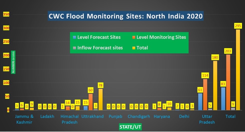
In this compilation, we have given state wise list of CWC’s level forecasting, flood monitoring and inflow forecasting sites in North India, comprising of Union Territories Jammu & Kashmir, Ladakh, Chandigarh, Delhi and states of Himachal Pradesh, Uttarakhand, Punjab, Haryana  and Uttar Pradesh. It includes available details like name of river, sub basin, Warning level (WL), Danger Level (DL), High Flood Level (HFL), Full Reservoir Level (FRL), Maximum Water Level (MWL), as applicable. As we see below, there are many gaps in this basic information for the sites that are part of CWC’s list. A similar zonewise overview of CWC’s sites was compiled in 2018 and 2019, which can be seen here: Overview of CWC Flood Forecasting Sites 2018: North India; Overview of CWC Flood Forecasting Sites 2019: North India. We have brought this updated compilation for 2020 as there are large number of changes.

Continue reading “North India; CWC Flood Forecasting Sites 2020; New Website Old Problems”
Delhi · Rivers · Urban Rivers

NAJAFGARH JHEEL – SAGA OF A FORGOTTEN RIVER

Guest Article by: Ritu Rao

A short drive on the Golf Course Road in Dwarka followed by a turn towards Goyla Dairy and subsequently a sharp left just short of Goyla Dairy brings us to the famous Inspection Road /Embankment Road. Flanked by Najafgarh Drain on one side and the arable lands of Delhi on the other, the embankment road was constructed after the 1964 floods of Delhi. The thick mud embankments are covered with trees and shrubs which provide the much-needed habitat for the local flora and fauna to thrive. This thicket starts clearing off after Jhatikara crossing (say after about a half an hour drive on this road) and the Najafgarh drain suddenly transforms into a vast expanse of water known as the Najafgarh jheel. This spectacular sight continues for a good 5-6 kms before it once again narrows down into a stream. The road meets the now extinct Sahibi Nadi and Outfall from Drain No.8 at Dhansa, 5 km upstream of the jheel. The Sahibi Nadi which originates in Jaipur district and drains parts of Rajasthan, Haryana and Delhi, now has diminished flow and disappears in the arid soil near Dharuhera after the Masani Barrage in Haryana. Once fed by the Sahibi nadi and storm water runoff from the surrounding areas, the Najafgarh jheel is now fed primarily by the waste water from the Badshahpur Drain and the Outfall Drain No.8 and the rain water in monsoons.

Continue reading “NAJAFGARH JHEEL – SAGA OF A FORGOTTEN RIVER”