Fed by Dudhatoli forest range, the Ramganga West and Nayaar East and West in Uttarakhand are perennial rivers of immense scenic beauty amid emerging and looming threats. This photo blogs highlights some of the charms and concerns of these non-glacial rivers of the Ganga Basin.
Travelling along Ramganga, from Bhikiyasain-Almora to Mehalchauri-Chamoli (about 90 kms)
Interactive google map of Ramganga river.
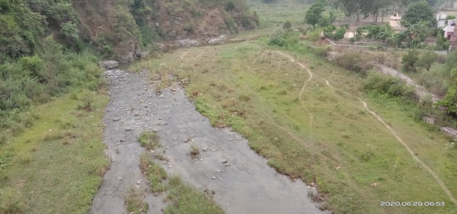
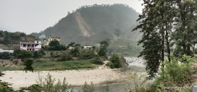
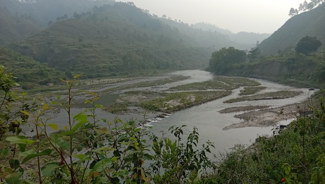
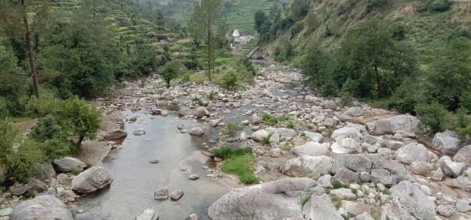
Google Earth map of Ramganga river in Uttrakhand. (Bhim Singh Rawat/SANDRP)My journey (incidental trip for family reasons) on June 29, 2020 began from Bhikiyasain in Almora. Here is Gagas river, just upstream of confluence with Ramganga river. A little further its fed by Naurar Gadhera. Like Ramganga Kosi too has wide floodplain indicating the historic floods and discharge capacity of the stream. Given lack of sufficient rain fall as monsoon is just setting in, the stream has been reduced to a trickle and the flows are seen having streams of algae. (Bhim Singh Rawat/ SANDRP)Moving upstream from Bhikiyasain: This is Ramganga at Jainal in Almora. The river winding though hills amid soil erosion rushing through the hill in background. It is as a result of ongoing road project there. Dumping of muck, debris, soil down slope indiscriminately has become common practice across the state having adverse impacts on vegetation, trees and river geo-morphology. Also tributary river name unknown meets Ramganga from left side at this location. (Bhim Singh Rawat/ SANDRP)At Chichroti, Almora road along river is being widened and the muck dump yard has been created at next turn. The river also forms wider floodplain there and the muck is gradually occupying the river space. At this location, Khatron nadi falls in Ramganga from right side. tributary (Bhim Singh Rawat/ SANDRP)While Lantana weed invasion is rampant along lower altitude along the river valley, growing at the expense of native shrubs, vegetation; Rambansa the Mexican devil also known as PagalJhad or mad shrub has taken over areas at higher altitude. Locals find both of no use as fuel, fodder or herb. However Lantana evidently provides safe refuge to wild animals and Rambansa exhibiting remarkable soil binding features hence quickly covering patches stripped off soil cover. (Bhim Singh Rawat/ SANDRP)Ramganga at its best, living and flowing freely near Budh Kedar before Maasi. Water currents hitting stones, pebbles in riverbed and creating oxidation, as essential part of river eco-system. The banks are full with vegetation and mix forest trees. Pine forest begin and reach upwards. Shores are littered with plastic waste. The only vegetation free part on the left corner at the bottom is approach road created by Ramganga stone crusher occupying large part of riverbed just upstream at Naugaon village. (Bhim Singh Rawat/ SANDRP)
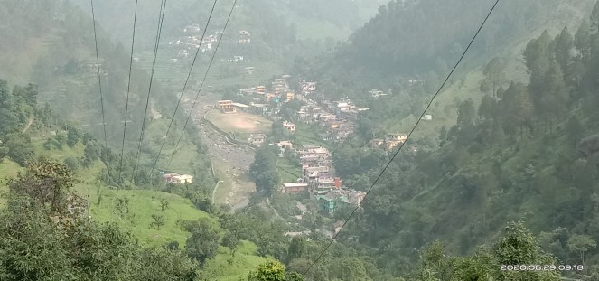
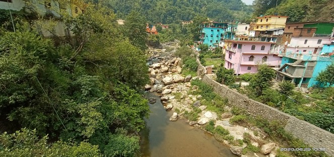
Ramganga stone crusher sitting right in riverbed. Locals say it began operation about five years back and was closed in July 2019 by Nainital High Court for being too close to the river, but after some months it restarted operations. Villagers also complained of the plant functioning during nights thus causing great noise pollution apart from manipulating river course. (Bhim Singh Rawat/ SANDRP)The mining scars all over wide floodplain just upstream the plant are testimony of river being indiscriminately mined. Binu a right bank stream from Chauthan merges into Ramganga here. (Bhim Singh Rawat/ SANDRP)While moving up, Chaukhutia is the last big market place of Almora district. From here river takes a long curve though deep valley covering Lambagad, Mithan, Maalkot, Agarchatti areas finally reaching Mehalchauri area of Chamoli district en-route Gairsain the summer capital of Uttarakhand. The solid and liquid waste of Chaukhutia market entering Ramganga river. The fate of bio-medical waste is apparently same. This is common abuse of river at most of the towns it passes through like is the case of other wild and mountain streams across the state. At the same time about 35 km long stretch along Ramganga between Bhikiyasain and Chaukhutia is among most fertile land full of farming and fishing activities changing from self-consumption to cash crops thus increasing demand of irrigation water from rivers. At places lift irrigation is also used and irrigation channels are being widened. Also between Kedar and Chaukhutia three streams from left and one from right join the river. (Bhim Singh Rawat/ SANDRP)Arial view of Mehalchauri town while descending down Pandakhal, Almora. A wall has been created along the river to protect buildings and a local stadium carved out of riverbed. The origin of the river Devali Khal is some 20 km from here. There are concerns about a trench built close to river in Gairsain, waste from where reaches the river and is also burnt frequently. With declaration of Bharadisain area of Garisain as summer capital, the water supply is planned by building a dam namely Chourda lake on Ramganga. (Bhim Singh Rawat/ SANDRP)Closer view of Ramganga river in Mehalchauri. All sorts of waste from the nearby by habitations is reaching the river directly or indirectly. (Bhim Singh Rawat/SANDRP)Closer view of Ramganga river in Mehalchauri. The riverbed is full with big boulders. (Bhim Singh Rawat/SANDRP)
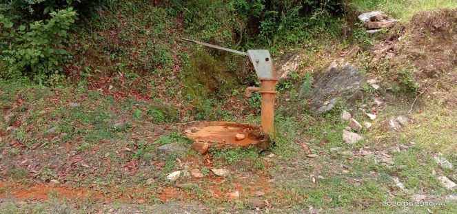
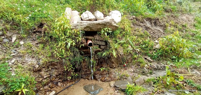
Uttarakhand, famous as land of streams, springs, rivulets and rivers have been building a lot of hand pumps over the years. This hand pump is by the road near Bina area in Mehalchauri while moving towards Nayaar basin. Locals don’t appreciate quality of hand pump water which is laced with heavy metals. As seems the case here of this hand pump seems to be belching iron rich water. At places lacking options, people have been using their water for various purposes. (Bhim Singh Rawat/ SANDRP)Hardly 3 km away this is traditional spring, a source of drinking water oozing out from the roots of a peepal tree. A small tank has been built to store and supply the water. (Bhim Singh Rawat/ SANDRP)
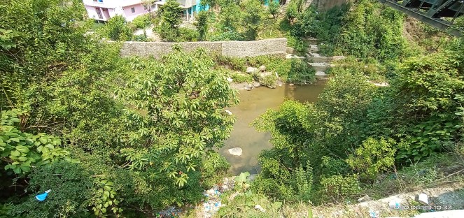
This wild stream is possibly a first order tributary of Ramganga rising from buffer zone of Dudhatoli forest near Nagchula Khal, the border point separating Chamoli, Almora and Pouri districts. They are also repository of native vegetation. Pipelines have been laid to supply domestic water to several villages from the stream. Washing of vehicles in the stream is common practice so is dumping of wine bottles and plastic waste. This stream joins Ramganga from right side at Mehalchauri. (Bhim Singh Rawat/ SANDRP)
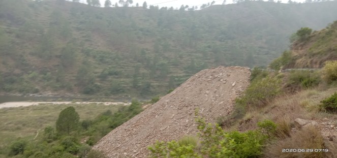
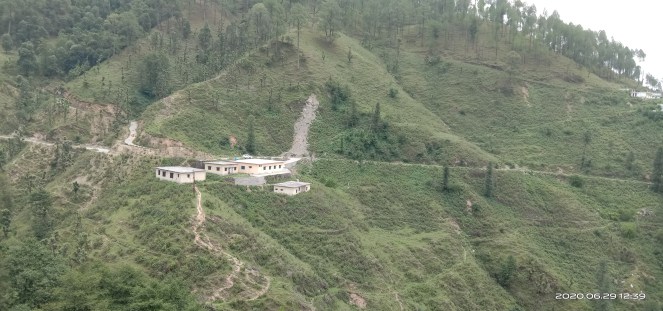
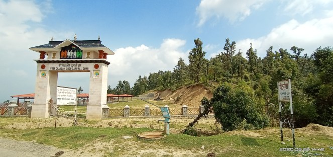
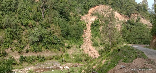
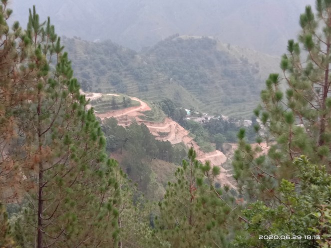
This place is close to Virudhuni in Chauthan patti of Thailisain block in Pauri. A hand pump has been built by the seasonal stream and villagers now prefer it for bathing and washing believing the source uncontaminated from surface pollution unlike the streams which have become dumping ground of village waste. (Bhim Singh Rawat/ SANDRP)The entire area has been witnessing increase in road construction activities. The muck and debris is being thrown down the hills. Patches of newly built roads are frequently washed away in rains before they stabilize. A small landslip can be seen here at Masangaddi. The hard rock at the point was cut after years of efforts to take the road forward. Last year the same location faced another landslip clamping down movements for a couple of months. The newly built protection wall is also visible. The Masangaddi stream feeds Binno stream at Deghat which in turn joins the Ramganga river near Chachroti in Almora. (Bhim Singh Rawat/ SANDRP)Another smaller but perennial landslip site at primary hospital at Bungidhar in Chauthan. The small bushes, underneath vegetation is primarily Rambansa covering entire hill scape. Binno river fed by a local rivulet flows at the bottom of the hill. (Bhim Singh Rawat/ SANDRP)Peethsain a hilltop location in Chauthan where a memorial gate and gathering ground for Veer Chandra Singh Garhwali, freedom fighter has been built recently, marks the separation of Ramganga and Nayaar rivers basin. The area is facing soil erosion for manmade reasons of construction, tilling and grazing. It is supposed to be rich in water resources, still a hand pump has been built. (Bhim Singh Rawat/ SANDRP)A natural water spring near Peethsain. Locals prefer spring water over hand pump supply as its taste sweet and cool. (Bhim Singh Rawat/SANDRP)
Through Nayaar Basin Now: Peethsain to Satpuli via Chaubattakhal (about 130 km)
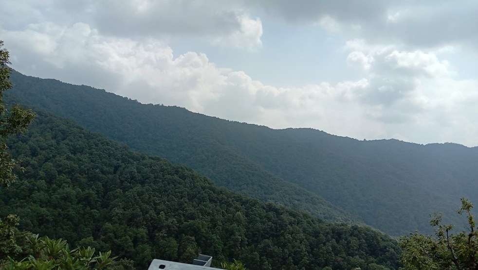
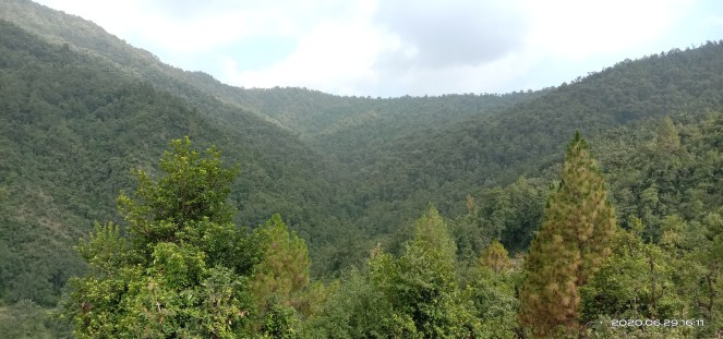
Google earth map of Nayaar rivers. (Bhim Singh Rawat/SANDRP)A portion of the Dudhatoli forest range in Thailisain tehsil, Pauri as the founding basin of Nayaar river. The region is rich in forest and water resources, a factor being officially acknowledged for comparatively low migration from the region. (Bhim Singh Rawat/ SANDRP)A woman working in field in Anthi village in Thailisain. A wine bottle at the edge of the road. Excessive workload & domestic violence due to immoderate liquor consumption by males are two of the biggest causes impacting physical & mental health of women. (Bhim Singh Rawat/ SANDRP)Landslip debris following road construction to Anthi village falling into a stream joining East Nayaar. Like Ramganga valley the region is also dotted with countless such locations. (Bhim Singh Rawat/ SANDRP)Portion of a check dam on Anthi village stream washed away in the flash flood last year. At places the water harvesting structures could be seen in neglected & damaged condition. Same is the situation about fish breeding tanks. (Bhim Singh Rawat/ SANDRP)
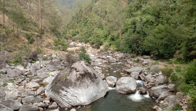
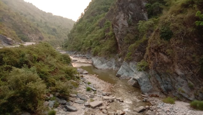
The wild East Nayaar river bed full of boulders and stones. The picture is some 10km downstream of its origin place near Byasi village. Due to deficit rains the water level has fallen in the river. (Bhim Singh Rawat/ SANDRP)
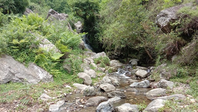
This is Byasi stream, a tributary of East Nayyar rising from buffer area of Dudhatoli forest. Local people are seen breaking the boulders at the bottom of image. The river stones are used in a wide range of construction activities. A water mill (Gharat) is also visible in operation upstream. There are few other perennial streams supporting watermill running round the year, the only source of grinding grains in the area. The stream in last week of May 2020 saw a flash flood and since then rainfall has been low. (Bhim Singh Rawat/ SANDRP)
On May 28 several parts of #Uttarakhand received heavy rainfall. A video shared by Ranveer S Bisht shows flash flood in a small stream of Byasi village in Thailisain Block, Pouri. The stream feeds E Nyaar & supports a mini hydel seasonally, a water mill visible in video yr round. pic.twitter.com/QUa0ocgsDt
Fields of Kaproli village in Thailisain and forest patch with freshly built double roads connecting village visible on the other side. Clouds hover over area, without precipitating. This is paddy sowing season and lack of rain has affected the farming. (Bhim Singh Rawat/ SANDRP)Captivating view of thick moisture laden air enveloping forest covered hills and merging into local clouds in Nayaar basin near Chaurikhal, Thailisain. (Bhim Singh Rawat/ SANDRP)Another picture of a village (probably Bhainswara) in Chaubattakhal tehsil showing how rural roads are being constructed with scant regard to soil and vegetation cover conservation. This serpentine road seems hardly motor able. The Machlad river, a tributary of East Nayaar is flowing downhill there. (Bhim Singh Rawat/ SANDRP)
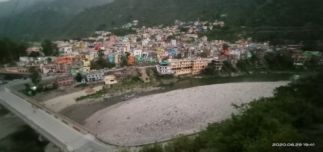
West Nayaar river at Molkhal en-route to Pathisain Pauri. The large stretch of road NH 119 on left bank of river has been doubled laned and in the process the debris have been pushed down the slope. The stretch is marked with several landslips along the hill post road construction. At places the protection wall has failed to check the destabilized slope falling on the road. (Bhim Singh Rawat/ SANDRP)Finally the East Nayaar passes through Satpuli town and West Nayaar joins it about 2km downstream near Rautela village. The Nayaar then flows northwards to merge into Ganga in Rishikesh. The Lansdowne hills separate the basin and rivers emerging from Kotdwar like Khoh, Silgad, Langurgad flow towards Ramganga basin. (Bhim Singh Rawat/ SANDRP)
The Ramganga and Nayaar rivers are significant part of National River Ganga. Fed by forest the rivers are rich in scenic beauty and aquatic and riparian biodiversity essentially serving large number of population with drinking, irrigation water, food, fish and minerals. They are among crucial abode for critical Mahseer fish.
The rivers are facing several existing threats while more are emerging including inattention by authorities. They are under pressure from unabated soil erosion primarily happening because of forest degradation, road widening and construction projects throughout the basin.
With changing farming practices and life style the demand for water abstraction from the rivers and streams feeding them is steadily on the rise, while local people share that overall water level in the rivers have declined over the years. The rampant disposal of solid, liquid waste into rivers has been affecting the aquatic life and water quality which needs to be studied and addressed in time bound manner.
Similarly the spread of invasive weeds is posing threats to riparian flora and fauna. The impact of excessive riverbed mining on the river eco-system and livelihood of local people are not yet being looked into or understood. And the climatic threats omnipresent across the basin can no longer be ignored.
Note The Ramganga West and Nayaar East and West rivers originate from Dudhatoli forest range in Uttarakhand from a height of about 2400 metres from mean sea level. The dense forest patch comprises of about 25 km long stretch in the border districts of Pauri and Chamoli Garhwal.
Known as Pamir (paradise) of Uttarakhand, Dudhatoli jungles are also source of many forest-fed perennial streams and seven non-glacial rivers including Ramganga and twin Nayaar rivers. While east and west Nayaar flows from the western side of Dudhatoli, the Ramgnaga (west) rises from the east direction. (The origin of Ramganga East is Namik glacier in Pithoragarh district and merges into Saryu river at Rameshwar near Ghat, Pithoragarh.)
All the three forest rivers flow perennially and feeds the National river Ganga. While about 190 km long Nayaar rivers merge together at Satpuli town in Kotdwar then flowing as single river to join Ganga at Vyas Ghat in Rishikesh, the Ramganga west runs a length of 596 km flowing through Uttarakhand and Bijnor, Moradabad, Rampur districts of Uttar Pradesh finally meeting Ganga in Hardoi district.
To know more about Ramganga West and Nayaar Rivers, please see SANDRP’s earlier blogs: