Guest blog by Aparna Datar
Hiroshima Hiroshima’s moral grip on our consciousness extends, beyond the Hiroshima Peace Dome, straight to the heart of India’s most urgent problem. The problem of balancing urbanization, growth, floods, and droughts in the face of climate change.
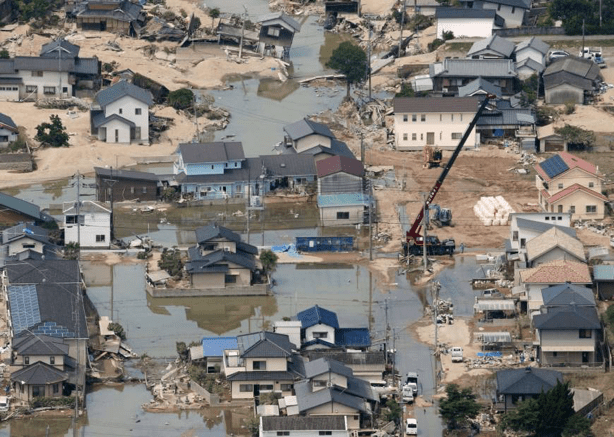
In the summer of 2018 devastating floods and landslides (blamed upon climate change) ravaged western Japan. With an unusually high death toll, for a nation that is used to counting the collateral damage more in terms of economic loss, than in terms of human lives, this one left a tragic number of people dead. Floods washed away large parts of Hiroshima, Kyoto, Okayama and Ehime. I joined Prof. Moe Nakazora, an anthropologist with the University of Hiroshima on a study tour of two of the worst affected villages in the eastern part of Hiroshima. These were the villages of Hachihonmatsu and Kouchi. Both the villages are located in Higashihiroshima which had more than 2000 landslides.[i]
HIROSHIMA’S LONG TRYST WITH LANDSLIDES
Hiroshima is no stranger to landslides.71 percent of the prefecture is covered with mountains and 50 percent of the land area is made up of fragile decomposed granite. Slopes fail when, torrential rains attack city’s residential areas, built upon such steep slopes burying down homes, roads, and bridges, in the debris. Almost 50,000[ii] locations[iii] in Hiroshima are designated disaster warning zones, the highest in all of Japan. Higashihiroshima (the eastern part of Hiroshima had the maximum number of slope failures and was the hardest hit.
KOUCHI AND HACHIHONMASTU: THE VILLAGES THAT CLIMATE CHANGE CAME HOME TO
Amongst the many challenges of climate change, the context of making justice as a paradigm for flood control assumes importance as much in the villages of Hachihonmatsu and Kouchi, as in may be a village in Uttar Pradesh.
The village of Kouchi, a pleasant drive from the Hiroshima University town of Saijo, is tucked away in the mountain slopes of eastern Hiroshima. Its modest population still has a handful of farmers. The average age of people of the village is quite old with the young choosing to stay away. Climate change has come to Kouchi’s elderly, in the lifetime of the villagers. 70 percent of the fatalities, in the torrential rains across western Japan were of people above 60 years old.[iv]

The JR Sanyo Trunk Line has been running through the mountains of this bucolic society for the last several decades. A heart warming peek into the Japanese work ethic, at the Hiroshima Station, was that the Americans dropped the atomic bomb on the city in first half of the morning. The same afternoon trains began plying back and forth between Hiroshima and Saijo! Hiroshima seems to be uniquely blessed with a capacity for hard work, intellect and a history of solid resilience in the face of problems, which will likely help spearhead the fight against climate change.
Kouchi’s river has embankments, lined with house on both sides. The spectacular once in fifty-year rain event or the “GOI-IEE” (Japanese word for a deluge) causing the landslides, were in their full ferocity here. The meteorological agency’s “special” warnings for unseasonal deluges are now more regular. A bridge stood witness to a huge chunk of concrete, a broken weir wall, hapless on the river bed amidst a sea of giant boulders from the mountains, each at least a couple of meters diameter or even more. A dam upstream had, had to have its emergency releases of water on account of the heavy rain. The flash flood that ensued, claimed homes, roads, weirs, a temple, a couple on their way back from lunch as instantaneous collateral damage. The bridge witnessing the destruction, was overwhelmed with the water. The flood unleashed waves of debris upon debris downstream and beyond. Amidst destroyed houses sat an unexploded gas tank that hung precariously in the rubble, over the water. An entire embankment was washed away in minutes.
An old couple living there narrated the harrowing experience of sounds of huge boulders crunching anything that came in its way, and the flood water bearing down upon their home. “I was sleeping, the sound woke me up, I was terrified, it was unimaginable”. The water overwhelmed their home and the embankment upon which it stood but the couple managed to evacuate safely.
Although we did not get to visit anything upstream of this dam, it nevertheless gets us to reflect upon any flood protection conflict that we see in any number of floods across India. Any flood risk that must be managed, will obviously be a function of legal, cultural, geo-hydrological, technical/ climate control variables/ givens. It is still entirely possible to allocate measures of flood protection or distribute its benefits so that, the vexed tradeoffs such as, the upstream being protected at the cost of downstream, or what makes such and such asset worthier for protection than the other, be addressed in manner that is entirely Just.
This is an imperative of any public discussions in India, where patronage relationships and local economics supersede all. The entitlements of the affected population, to accountability and transparency of information must be treated as a very key component in our present times of changing rainfall patterns and natural degradation of environments.
Much like back home, news in Japan at the time was full of, municipalities where no one was managing, (the national or the prefectural govt) the water level and a lack of communication. In the village of Mabicho[v] in Okayama prefecture (about 200 km. away from Hiroshima) villagers complained of flash floods from excess releases of water from dams by the dam operator. The village was swamped when the river flowing through the village breached the banks at the confluence of another tributary.[vi] As a flood control measure the government (controversial as it may sound) planned on widening the river and moving the confluence downstream[vii]. But the project just could not start before the floods came, with Mabicho bearing the brunt. The floods came before the project could commence.
Scores of municipalities make such[viii] requests, but not all can be accepted, bringing to fore the issues of justice in entitlements at least at the individual village level (I speak only from the perspective of the idea of the access to an entitlement, the wisdom of moving rivers is entirely questionable[ix]. In Japan a lot of local level resident participation is involved in the managing natural disasters. While there’s a fair degree of utilitarian and egalitarian nature to this, in that the flood control is essentially allocated and provided for by state funding, for Mabicho that did not help. It was the worst hit of all villages with more than 4000 homes flooding, and the most heartbreaking stories coming out of this district.
SOME RESPONSES AND SOME LESSONS: IMPACT UPON CAPABILITIES
The resident group coordinating relief activities after the flood in the Hachihonmatsu village told us that the Japanese Govt. had provided for a nation wide assistance of 500 billion yen. Which brings us to the nature of public finance/ public goods for flood related natural hazards in times of a fast changing climate. The “Training Storms”[x], where storm after storm line up like train wagons and unleash upon fragile slopes, experienced this time in Hiroshima were also put down to climate change.[xi] Experiences of Kouchi and Hachihonmatsu during the storms will also provide a context for India.
In states like Uttarakhand, which loose soil more than annual tolerance level, landslides related soil loss substantially destroy agricultural land. Deforestation is an important cause of landslides. The fallacy of the idea that a plantation can replace a natural forest to stem a natural disaster is borne out by Hachihonmatsu experience, where condition of the forest and the wood played out in how landslides occurred. Human managed forests did not prevent landslides according to the Resident group, while natural forests were able to. The random, chunky nature of the forest left far little space between trees for the soil to escape, but that did not occur in a plantation.
Majority of the people are engaged in farming in the Himalayan States, who face the climate onslaught on the Himalayas, and the uncertain outcome on livelihoods[xii]. For these villages across diverse environments and countries protecting forests helps them protect the Capabilities[xiii] of the most vulnerable.
The smaller the village, larger is the impact on a large number of indices of capabilities of the people. In India we have to be careful climate change does not become another means to suck out public funds from essential needs into big public infrastructure used essentially by the well off. Over 200 million people live in Uttar Pradesh, and Uttarakhand. 70 percent are engaged in occupations related to agriculture in rural areas. The Hiroshima floods caused over 600 billion yen losses to agriculture and Japan spent a matching amount in relief.

RESPONSE MAY NOT HELP SUFFICIENTLY
Relief may not always mitigate the deleterious impact of climate induced flood upon the many resources of the village residents. Scores of villages man relief entirely themselves, on the same lines as managed most of the times by the affected themselves in India.
In the village of Kouchi the elderly gentleman who seemed to be the spine of the relief work took us to the spot where part of the Japan Rail (the nations largest train operator) Sanyo Train line had collapsed[xiv], which had now been repaired. This was the same line that withstood the Atomic bomb and I thought in many ways seemed symbolic of the challenges that face Hiroshima. For scores of decades it had been perched precariously in the steep fragile granite mountains. This summer, come rains and the mountain soaked with water triggered landslides and took the train line down with it. The gentleman in question Kameyama San narrated his experience at this location, of carting a genset into the mountains for a community that was stranded with access cut off. In both the villages public infrastructure like roads, bridges etc were destroyed. Water, communication, sewage and most importantly, electric power, was cut off. The approach to this spot was cut off because of the landslide.
Kameyama San who seemed to be nearing 70s physically transported the genset on his back, on a dangerous long walk, climbing parts of the crumbling mountain using rope in places. Immediately following the floods this area was hit by a sweltering heat wave, with river below still flooded. Power to the pumps had to be restored and communication lines re-established. There was no one except Kameyama San for a, job that was clearly cut out for trained personnel or para military forces.
For example, the Jietai or the JSDF (Japanese Self Defense Forces) he explained, came only for locating missing people to be pulled out from under the rubble, the specific brief given to them.
A few minutes walk from this spot was a house that was washed away and the JSDF forces were very much there for rescuing people. But that was their brief. They were unable to respond to any other aspect of calamity around them, it was left to Kameyama San to reach the genset home. A 70-year-old upon whose aging shoulders, the capability of an entire trapped mountain community rested. Scores of elderly were at the forefront of such activities.
In Hachihonmatsu specialist city officials who came to the Government evacuation center had no knowledge or did not participate in operations. The village’s evacuation center had to be managed by the victims organizing their own food, medicines etc. It took the government two weeks to confirm damage after which help arrived to Hachihonmatsu in the first place.
“PEOPLE’S SENSE OF SAFETY”
The Resident Group at Hachihonmatsu said “Residents need to depend upon themselves”. Prof. Moe Nakazora, the anthropologist at the Hiroshima University speaks of a phenomenon she calls “People’s Own Sense of Danger” where people use past collective experience and build traditions to live with a natural hazard instead of relying on say an engineering structure like a sea wall or dam, a sediment dam etc. Such experiences, this “Peoples Sense of Danger” must be a part of any Public policy when we are faced with climate change and regular folks, on trained personnel face the immediate brunt of the disaster. People’s Sense of Danger is what the Residents of Hachihonmatsu and Kouchi seemed to have based their Local Disaster response around. Within the villages of Hachihonmatsu even before govt. issued warnings about any possible lake or dam breaches, people expected them, and twitter played its role in allying peoples own sense of safety.
“Residents need to depend upon their own experience, second guess warnings/ levels issued by the government. It is better to read weather, understand the terrain, go on community walks with maps, so it aids in self help relief” said the Hachihonmatsu Resident group. In many places the evacuation warnings came too late[xv] and in others despite warnings people did not evacuate, expecting flood prevention to work. In all of Hiroshima only 3 percent of the people evacuated following[xvi] government warnings. People had no social record or institutional response to such a large unexpected event[xvii].
In the village of Kouchi however the dam might have interfered with a more traditional method like building residential areas only in elevated places (which existed in Japan in the past[xviii]). The dam in Kouchi flooded although people expected it not to. People did not respond to evacuation warnings here too. Even resilient communities of Hiroshima are vulnerable despite their competence and history of living with land slides and floods.
This is also relevant to India’s cities. In the city of Pune where I am from, increasing number of urban commercial properties are directly within the river beds. Many properties dangerously flirt with the flood lines. There is the willful blurring of the lines as to what is within the riverbed, hill tops, and what is not. We have no insurance, if a residential home is washed away, normally there is little flow within the river, (because water is trapped by upstream dams), the fast changing rainfall patterns, and in this context the absence of any social memory of a deadly flood, are all an open invitation to a hazard with no matching peoples/ social institutional response ready against a possible flood. The nature of climate change is such that erratic pattern of deluges will not fit any social memory, or the size of present engineering structures.
The climate change response must consider these since they are so deeply connected with people’s resources (of even the better off regular city folks, let alone the other India.) Massive public budgets for large engineering structures drive public policy in India, and the interlinkage of people’s social memory is important in this context.
Impact upon resources of the most vulnerable can be unforgiving. For instance, in Japan if your home is washed away, you get a part that the insurance might cover, but for all practical purposes your home is lost. The state provides temporary housing, (way far away, even as far away as Tokyo). For an elderly couple the impact of this loss is extreme.
TOWN PLANNING, CLIMATE CHANGE AND SOCIAL MEMORY: 35 million live in flood zones
The impetus to rebuild Japan after the war turned Hiroshima into an industrial, high-tech megapolis with an exploding population. The expansion of the city into the mountains made it ever so vulnerable to sediment related disasters. More and more people are now living in areas designated as flood prone by the government, with huge swathes almost a perfect match the hazard maps[xix].
Of the many landslides , one land slide in Hiroshima in 1992 became the trigger for establishment of the nation’s sediment disaster prevention legislation, stipulating licensing for residential buildings, moving buildings away from the path of any potential sediment disaster[xx], map the designated warning area and distribute hazard maps.[xxi]
Under the act the prefectural governments now designates “sediment disaster area” as a yellow zone and special alert area, a red zone[xxii]. The number of caution zones have shot up 7 times in the last decade, with 31,000,00[xxiii] across Japan designated by the government as areas at risk of landslides.
To begin with Japan had strict rules for constructing houses or building villages in certain areas. For instance, houses needed to be elevated if they came in flood prone areas. But with changing goals of town planning[xxiv] following the WW2, the goal was to bring the maximum amount of investment in land use, so as much of urban areas was used for residences, infrastructure and transportation, with punitive incentives associated with owners not bringing land under any of these. Many of Hiroshima residential areas are formerly flood prone farmlands, converted into residential properties. Urbanization superseded safety, the lines delineating safe and unsafe areas increasingly obliterated.
In many parts residential zones are now declared as at risk to landslides, while they formerly were not. Some newer residents may not be aware of the whole thing at all before making any purchase with no penalties involved to regulate the sale of such a property.
This piecemeal approach to protecting residential areas either from landslides or floods did not help villages of Kurashiki and Mabi in Okayama which were the hardest hit by floods and were covered extensively on TV. They grew in the 70s on the flatlands by the river. Despite being aware that levees may give away, and both towns having a history of flooding, were developed into residential areas.
About a couple years back Kurashiki came up with its own hazard maps as per legal requirements. The maps were tragically accurate, large swathes of Mabi were a perfect match to the Mabi under water now.
The most famous story of the flood in these parts was that of a grief stricken father rocking the body of his five-year-old step son. His mother was not found at all. Residents were already invested psychologically and emotionally to move, too old or simply paid scant attention to the hazard maps because there were no insurance or other related penalties that might force their attention to the fact that they were living in the path of danger.
If an area is declared as caution zone local government is required to create evacuation plans and hazard maps.
The impact on real estate prices of this zoning cannot be ignored. The news then spoke of some community or the other that were constantly battling opposition to get a certain area declared as being within a zone, from everywhere: the residents themselves, the politicians and the real estate sector. The prefectural government regulates the land use and one cannot help but think town planning can play a huge role in averting colossal economic losses and also losses of human life.[xxv]
Experts recommend that in metros like Tokyo, parts of flood plains to accommodate the natural flooding be bought by the government for the express purpose of it being allowed to flood. These new town planning ideas are now supplemented by experts asking people themselves to be better understand if the real estate they buy is risky or no.
Climate change awareness, is very much impacting the way public infrastructure is slowly evolving for Japan. For Hachihonmatsu and Kouchi, where the JR Sanyo line collapsed as the mountain that cradled it came undone, the plans for an additional three train lines proposed through the fragile mountains have been suspended.
The lines that delineate risky areas have been blurred on account of the earlier town planning goal[xxvi]. In Mabi when the village flooded, the authorities knew exactly where it would flood. In Hiroshima older residential areas sat on landslide prone locations which were earlier declared to be safe enough to be developed as residences.
The older town planning goal now needs to evolve to make these lines clear to the people so they are aware of how and where they live and invest. That is the most important tool in our arsenal against climate change.
Aparna Datar (aparnanitindatar@gmail.com)
END NOTES:
[i] https://www.japantimes.co.jp/news/2018/07/27/national/slope-failures-rain-disaster-top-7000-southern-hiroshima-including-mountain-tops-survey/#.XFpTG88zYRb
[ii] http://www.mlit.go.jp/sogoseisaku/inter/keizai/gijyutu/pdf/sediment_e_02.pdf
[iii] http://www.asahi.com/ajw/articles/AJ201812240033.html
[iv] http://www.asahi.com/ajw/articles/AJ201807130031.html
[v] https://mainichi.jp/english/articles/20180711/p2a/00m/0na/009000c
[vi] https://www.japantimes.co.jp/news/2018/07/11/national/risk-deadly-flood-badly-hit-area-okayama-prefecture-known-advance/#.XFfT0c8zY8Z
[vii] https://www.japantimes.co.jp/news/2018/07/11/national/risk-deadly-flood-badly-hit-area-okayama-prefecture-known-advance/#.XFfT0c8zY8Z
[viii] http://www.mlit.go.jp/en/index.html
[ix] In Mabicho they were going to physically move the confluence of the two rivers further downstream away from the village because they expected this to vulnerable to flood. The course of one of the channels was supposed to be slightly changed in addition. In many cities like Nagoya the course of the entire river was completely changed, a big commercial /govt. hub of Nagoya actually was the location where the river flowed through in the past, but just before the war it was completely moved out of Nagoya. You can find this in many places in Tokyo as well. A big river in Tokyo is moved out of residential parts for flood control. Since the earliest times rivers were brought in the city from outside to feed moats and other water supply bodies as castles started to be built ever since 1700s. They are channeled away from undesired locations to where populations are sparse or uninhabited or the other way round or made to join other rivers. The flow of the river is turned away into the new channel. In fact, all of Koto ward in Tokyo is built almost entirely in places where the Sumida, Arakawa river or just plan marshes existed in the past. Other similar wards very much exist in Tokyo. These are all very much flood prone and form a big chunks of Tokyo’s hazard maps.
[x] https://edition.cnn.com/2018/07/13/asia/japan-floods-intl/index.html
[xi] https://www.nishinippon.co.jp/nnp/national/article/431564/
[xii] https://www.theguardian.com/environment/2019/feb/04/a-third-of-himalayan-ice-cap-doomed-finds-shocking-report?CMP=fb_gu&fbclid=IwAR2MmlxtDeoCHHSICzLABY2mTrbIntZR6t7slZXtigWJ_lKXAUz5P658620
[xiii] https://www.amazon.com/Development-as-Freedom-Amartya-Sen/dp/0385720270
[xiv] http://www.asahi.com/ajw/articles/AJ201807190042.html
[xv] https://mainichi.jp/english/articles/20180710/p2a/00m/0na/009000c
[xvi] https://www.japantimes.co.jp/news/2018/08/03/national/3-6-percent-hiroshima-residents-evacuated-july-rain-disaster-struck-survey/#.XFpi_88zYRb
[xvii] https://www.japantimes.co.jp/news/2018/07/10/national/vulnerable-geography-seen-keeping-well-prepared-japan-prone-deadly-downpours/#.XFrlKs8zY8b
[xviii] http://www.rmmagazine.com/2018/11/01/storm-surge-lessons-learned-from-the-2018-japan-floods/
[xix] https://www.japantimes.co.jp/news/2018/12/17/national/number-people-living-flood-prone-areas-japan-risen-4-4-20-years-research-shows/#.XJrvyuszZmO
[xx] https://docplayer.net/26533483-Countermeasures-for-sediment-related-disasters-in-japan-using-hazard-maps.html
http://www.nilim.go.jp/english/annual/annual2017/pdf_file/4.pdf
[xxi] https://docplayer.net/26533483-Countermeasures-for-sediment-related-disasters-in-japan-using-hazard-maps.html
[xxii] https://www.japantimes.co.jp/news/2018/12/17/national/number-people-living-flood-prone-areas-japan-risen-4-4-20-years-research-shows/#.XFrnIc8zY8a
[xxiii] http://www.asahi.com/ajw/articles/AJ201812240033.html
[xxiv] https://jica-net-library.jica.go.jp/en2/index.html
[xxv] https://english.kyodonews.net/news/2018/07/f75096fa9b2f-western-japan-rain-disaster-causes-120-bil-yen-of-agricultural-damage.html
[xxvi] https://jica-net-library.jica.go.jp/library/jn325/UrbanLandUsePlanningSystem_all.pdf

very brilliantly brought to the fore the need for new town planning techniques.
LikeLike