
About West Bengal
Area: 88752km2; 20 districts; Population- > 91 million Topography: Mountains, Plateaus and Plains.
About West Bengal Rivers
The state of West Bengal, a land of many rivers, covers an area of about 88,752 km2 and is the home of more than 90 million populations as per census of 2011. The Ganga divides the state into two unequal hubs: the North and South Bengal. The state has been divided into 20 districts, the seven districts are within North Bengal and remaining 13 districts are in South Bengal. West Bengal is the only state of India that extends from the Himalaya in the north to Bay of Bengal in south. It offers wide topographic diversity and intricate drainage network of 29 basins. The south Bengal can further be subdivided into two geographical units taking Bhagirathi-Hugli river (the western distributary of the Ganga) as the demarcating line. The western part is called Rarh Bengal and the eastern part is described deltaic Bengal. The rivers of West Bengal have been divided into five groups: i) the rivers of North Bengal; ii) the Ganga-Padma system; iii) the Bhagirathi- Jalangi-Churni system; iv) the western tributaries to Bhagirathi and v) the tidal creeks of Sundarban.
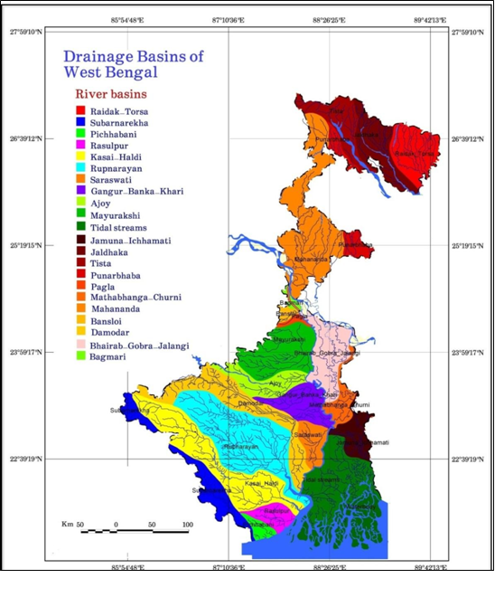
River Basins
The Central Pollution Control Board and West Bengal Pollution Control Board have identified different stretches of 17 rivers as polluted based on BOD load. The fecal coliform count in most of the rivers were found above threshold limit.
| Polluted River Stretches in West Bengal | ||
| Priori ty | Criteria | WB Status |
| I | Monitoring locations exceeding BOD concentration 30 mg/l has been considered as the standard of sewage treatment plant and in river it appears without dilution. (River locations having water quality exceeding discharge standards for BOD to fresh water sources). | NIL |
| II | Monitoring locations having BOD between 20-30 mg/l. | NIL |
| III | Monitoring locations having BOD between 10-20 mg/l. | 4 |
| IV | Monitoring locations having BOD between 6-10 mg/l. | 2 |
| V | Monitoring locations having BOD between 3-6 mg/l. | 11 |
| Sl. | River | Stretch Identified | Towns / Urban Agglomerates Identified | Stretch Length (In Km) | Priority Level |
| 1. | Barakar | Kulti To Asansol | Chittaranjan, Kulti, Burnpur, Asansol | 20 | V |
| 2. | Churni | Santipur Town To Majhadia | Ranaghat | 30 | III |
| 3. | Damodar | Durgachakm To Dishergarh Vill | Udayanarayanpur, Bagnan, Durgapur, Asansol | 200 | IV |
| 4. | Dwarakeshwar | Bankura To Kushtia | Bankura | 20 | V |
| 5. | Dwarka | Tarapith To Sadhak Bamdeb Ghat | Chandipur, Tarapith, Bishnupur, Margram | 50 | III |
| 6. | Ganga | Tribeni To Diamond Harbour | Berhampore Kanchrapara, Hooghly, Naihati, Chandannagar, Bhatpara, Barrackpore, Baranagar, | 50 | V |
| Sl. | River | Stretch Identified | Towns / Urban Agglomerates Identified | Stretch Length (In Km) | Priority Level |
| Kolkata, Howrah, , Palta, Dakshineswar, Uluberia | |||||
| 7. | Jalangi | Laal Dighi To Krishna Nagar | Krishnanagar, Chapra | 20 | IV |
| 8. | Kaljani | Bitala To Alipurdwar | Hamiltonganj, Alipurduar | 30 | V |
| 9. | Kansi | Midnapore To Ramnagar | Medinipur | 25 | V |
| 10. | Karola | Jalpaiguri To Thakurer Kamat | Jalpaiguri | 50 | V |
| 11. | Mahananda | Siliguri To Binaguri | Siliguri | 50 | V |
| 12. | Mathabhanga | Madhupur To Gobindapur | Majhdia, Krishnaganj, Durgapur, Swarnakali | 80 | III |
| 13. | Mayurkashi | Suri To Durgapur | Suri, Sainthia | 95 | V |
| 14. | Rupnarayan | Kolaghat To Benapur | Bagnan, Kolaghat, Tamluk | 20 | V |
| 15. | Silabati | Ghatal To Nischindipur | Ghatal, Nischindipur | 25 | V |
| 16. | Teesta | Siliguri To Paharpur | Jalpaiguri, Siliguri | 10 | V |
| 17. | Vidhadhari
(Tidal) |
Haroa Bridge To Malancha Burning Ghat | Haroa, Minakhan, Malancha | 15 | III |
A report by Dr. Kalyan Rudra (rudra.kalyan@gmail.com)
You may also like to see Rajasthan Rivers Profile
NOTES:-
- This report was commissioned for India Rivers Week 2016.
- The report is a short description, for detailed report kindly explore the link West Bengal Rivers
- West Bengal Rivers Profile can also be seen on India Rivers Week blog
