

Feb 13, 2015: The picturesque Zanskar Valley in Jammu and Kashmir State in Northern India continues to remain under threat as one of the tributaries of the Zanskar River has been blocked by a massive 200 ft high landslide dam (equal to height of a 20 storey building). The landslide dam between Shaday Sumdo and Mar Shun in the Zanskar subdivision of Kargil district has created about 14 km long lake, whose size is increasing with every passing day. Life and properties of around 4000 people are at risk due to the possible flashfloods when the landslide dam breaches.
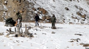
On Feb 12, 2015[1], a team of four persons landed on the river block for the first time since the landslide, with the help of Air Force Helicopters to take stock of the situation on ground. The team comprising R K Varma (Scientist DRDO) Maheshwar Singh (Survey Officer) Major Dheeraj Pohad (70 Engineering Regiment) and Skalzang Wangyal (Executive Councillor, Zanskar Affairs, LAHDC) surveyed the sight at an altitude of more than 14000 feet and in freezing conditions. Earlier a 10-member team headed by V D Roy, Director of the Central Water Commission had conducted an aerial survey of the river blockade on February 10. Some of the activities that team undertook included collection of soil/rock samples, ground reconnaissance of the site and volumetric analysis of the reservoir. As a result of the study, the dimensions of the blockage that have come to the fore include: the blockade is 400 m long along the river bed, 50 m high and 100 m wide across the river bed. The team will do further analysis and submit a detailed report suggesting possible solutions.
After a video conference meeting on Feb 12, 2015[2], the last day of the 5 day trip to the area by the 8 member NDMA team, a video conference was held with Leh, Kargil and Srinagar officials and also NDMA officials in Delhi. “We have prepared the rehabilitation and relocation plan to ensure that human lives and property are saved,” said Rohit Kansal, Divisional Commissioner of Kashmir. This seems to indicate that there is no plan except to wait and watch for the snow melt season to come and see how the situation develops.
The landslide dam is made of mostly fine grained debris. While the lake is frozen till now, the threat of its breach looms as soon as the melting season starts. The landslide dam was reportedly created on Dec 31, 2014, when a whole side of mountain soil had landed on the Phuktal River. The landslide lake has been accumulating water for over six weeks by now.
The location ((N 33° 17′ 25.3″ & E 77° 17′ 06.8″)) of the landslide dam[3] over fast flowing Tsarap or Phuktal River (a tributary of Lungnak River, which in turn is a major tributary of Zanskar River, which is a tributary of Indus River) is near Marshun village, about 90 km from Padum, the sub-divisional headquarters of Zanskar, 43 km of that distance has to be trekked on foot. Sudden reduction of flow in the river at the downstream Nimoo Bazgo Hydropower project of NHPC Ltd raised the suspicion of the landslide and this was ascertained only after a flight over the river path two weeks after the landslide occured. The earliest news is dated January 17, 2015.[4] The reports indicated than that National Disaster Management Authority (NDMA) was immediately alerted then, but the NDMA team reached the area only on Feb 9, over five weeks after the landslide occurred and over three weeks after NDMA was alerted about the incident.[5],[6]
As of January 20, 2015[7], according to an analysis of satellite imagery collected by the Indian Space Research Organization’s CartoSat-2, the artificial lake that formed behind the dam was nearly 8 kilometers long and covered about 55 hectares. By Feb 9, 2015, the lake had collected 30-35 million cubic meters of water. The lake has become 14 km long as per the latest images from NRSC.

What is the government doing The district administration informed media that they stationed police personnel at Chilling and Nerak[8] and have started on January 25[9] air lifting of the stranded tourists. However, that airlifting stopped midway due to bad weather and resumed only on Feb 9, 2015.
After surveying the situation on January 18, 2015, a team of civilian and military engineers discouraged authorities from using explosives to clear the blockage as doing so could trigger additional landslides. Such explosion is also ruled out as the valley is narrow with 70 – 80 degree in gradation, which will further accumulate more soil and boulder.[10] This creates a difficult dilemma for the disaster management agencies. While the chance of a catastrophic flood is lower in winter with the lake frozen, the risk will increase when temperatures rise in the spring, which is round the corner. As V K Joshi wrote in response to SANDRP blog on this landslide, “I had the privilege of working in this area of Phuktal Gompha and further downstream along Phuktal River and Lunek Chu in 1975. During summers these rivers are mighty roaring mass of water.”
However, one report, quoting anonymous sources says that the government has decided to use explosives to demolish the landslide dam. However, there are no details in the report except unattributed statement that they plan to use explosives. We will have to wait for more details to get clarity. Another report in Tribune on Feb 14, 2015 gave more definite indications that the government is planning steps to “to get rid of this problem” as “some immediate action is needed to be taken to avert the threat”. The next steps will be decided after a meeting called by NDMA on Feb 18 in Delhi, where more detailed report from on the sport inspection will be deliberated.
Is this part of the impact of Climate Change? Scientists have been saying that global warming will increase possibilities of such incidents, but science is unable to say if specific incident is due to global warming. “We cannot say off hand whether it is because of the global warming,” that assessment will have to wait, said the officials.
CWC director Roy who headed the NDMA team recommended installing an automatic river water monitoring system near Phutkal River to keep give hourly updates on water level using satellite powered transmitters. He recommended manual observers at Phuktal and a second warning system at Padum using satellite-based transmitters. It is not clear when these will be implemented.
Earlier on Jan 20, 2015, known as the the glacier man of Ladakh, Sonam Wangchuk posted on his face book page[11] a post suggesting a possible solution to the landslide blockade of Phutkal River.
Geologist Sandip Pandita of Jammu University, said that Ladakh is known for its loose soil and the occurrence of such landslides should not be surprising. “The area, being a cold desert, is devoid of any vegetation and thus prone to landslides especially near rivers. In Ladakh, as we have seen during the August 2010 floods, the water collects the debris and becomes saturated making it more dangerous.”[12] This also means that longer the water accumulates, the risk of downstream damages goes up.

NRSC images of Feb 7, 2015: Water Spread is increasing NRSC (National Remote Sensing Centre) of ISRO (Indian Space Research Organisation) has started monitoring the situation[13]. As per the latest update on its website on February 12, 2015, the high resolution Cartosat-2 satellite data (1 m spatial resolution) of 7-Feb-2015 has been acquired by NRSC. As per this image, an increase in water spread is observed, the length of the water spread has hugely gone up, the image also shows the increase in width of the reservoir, but NRSC website does not provide the exact figures of increase in length, width, area and possible volume of the reservoir or how much higher it is from the previous image of Jan 25, 2015.
Deputy Commissioner, Kargil, said that in case of the sudden bursting of the stored water from the artificial lake, a total of 29 villages (one report says 40 villages) and some 50 bridges and other properties in Kargil district would get affected. The Nimoo Bazgo Hydropower Project and also parts of Leh Town could be at risk, said the local Member of Parliament.[14]
Nimmo Bazgo HEP in line of possible flashfloods The 45 MW Nimmo Bazgo Hydropower Project of NHPC[15] on river Indus in Leh District also is downstream to the landslide dam. It has a 57 m high Concrete Gravity Dam (the landslide dam blocking Phutkal River seems higher than that. The lean season generation was expected to be low (10.43 Million Units in January 2014 as per Central Electricity Authority figures[16]), and was about 40% lower in January 2015 compared to same month in previous year. These figures show the possible impact of landslide dam on the upstream. The project is in the line of floods that the breach of landslide would create, but it is not clear if and what consequences the project may face.
Some recent events of similar nature In Aug 2010, the flashfloods triggered by a cloudburst in Leh caused massive damage to life and property. In January 2010[17], landslide dam in Attabad in Northern Pakistan led to death of 19 and large scale destruction. In Sept 2014, Jammu and Kashmir also witnessed unprecedented disaster due to floods triggered by incessant rains. In Aug 2014, Sunkoshi sub-basin in Nepal saw massive landslide dam leading to death of 123 and destruction included damage to downstream hydropower projects. However, such a landslide blocking the river seems to be the first ever known incident for Ladakh.
In Conclusion As I write this on February 13, 2015, there are as yet no information as to what the NDMA plans to do about this emerging disaster, the NDMA website is totally silent on this issue, the Leh Administration that provided the first notice of the event on January 17, 2015 has no further update, J K Envis website takes no notice of this event and it is not clear if the monitoring station has been put up with necessary communication system.
Agitated over government inaction at all levels, Scores of students under the banner of the All Zanskar Students Association assembled outside Exhibition Ground in Jammu on Feb 4, 2015[18] demanding immediate action, raised slogans against the administration for its failure in finding a solution to the threat posed by a 14-km-long artificial lake formed by a massive landslide in the Phuktal. Earlier on Feb 3, 2015, Ladakh MP Thupstan Chhewang met the Union Minister of State of Home and complained[19] about the inaction from centre on this crucial issue.

Following my earlier article on this issue[20], some media did pick up this issue, but there is no consistent follow up or focused interest from national media[21] on this developing story from remote Northern border area that could turn into a massive disaster.
We hope this situation improves soon and the issue is resolved with minimum damage.
Himanshu Thakkar, ht.sandrp@gmail.com, SANDRP
PS: Subsequent blog on this subject on Feb 21, 2015: https://sandrp.wordpress.com/2015/02/21/landslide-blockage-threat-in-zanskar-valley-to-continue-for-more-weeks-update-2/
END NOTES
[1] http://www.dailyexcelsior.com/ndma-team-lands-phuktal-river-blockage-site-conducts-analysis/
[2] http://www.tribuneindia.com/news/jammu-kashmir/ndma-to-submit-report-on-phuktal-river-blockage-soon/41373.html
[3] The exact coordinates provided for the site are N 33° 17′ 25.3″ E 77° 17′ 06.8″ as per: https://www.facebook.com/notes/the-quint/disaster-looms-in-ladakh-but-is-anybody-listening/406548059512388
[4] http://www.kashmirlife.net/in-ladakh-chadar-trek-closed-for-tourists-71932/ dated Jan 18, 2015
[5] http://www.tribuneindia.com/news/community/j-k-artificial-lake-ndma-team-to-assess-threat/35844.html
[6] http://www.greaterkashmir.com/news/2015/Feb/10/phutkal-river-blockade-ndma-team-reviews-contingency-plan-46.asp, http://www.tribuneindia.com/news/community/ndma-s-aerial-survey-of-phuktal-blockage-today/39910.html
[7] http://landsat.visibleearth.nasa.gov/view.php?id=85149
[8] http://www.outdoorjournal.in/news-2/ban-on-ladakhs-chadar-ice-trek-after-landslide-blocks-river/ dated Jan 18, 2015
[9] http://www.dailyexcelsior.com/airlifting-people-stranded-zanskar-region-begins-2/
[10] Sphere India SITUATION REPORT 1: BLOCKAGE OF PHUKTAL RIVER DUE TO LANDSLIDE dated Jan 21, 2015
[11] https://www.facebook.com/wangchuksworld
[12] http://www.thethirdpole.net/huge-landslide-blocks-river-threatens-ladakh/
[13] http://www.nrsc.gov.in/Phutkal.html
[14] http://www.thethirdpole.net/huge-landslide-blocks-river-threatens-ladakh/
[15] http://www.nhpcindia.com/projectdetail.htm?CatId=1&ProjectId=39
[16] http://cea.nic.in/monthly_gen.html
[17] http://www.landslideblog.org/2010/01/landslide-at-attabad-village-hunza.html
[18] http://www.tribuneindia.com/news/community/ndma-team-to-reach-ladakh-on-february-8/37915.html
[19] http://www.dailyexcelsior.com/ladakh-delegation-meets-rijiju-takes-important-local-issues/
[20] https://sandrp.wordpress.com/2015/02/01/landslide-dam-blocks-zanskar-river-tributary-threatens-valley/ on Feb 1, 2015, also carried by other sites including: http://scroll.in/article/703953/Landslide-blocks-Zanskar-River-tributary-threatens-region-with-flash-flood
[21] Besides the CNN IBN story (https://www.youtube.com/watch?v=Bg3pJ4qYk8U) there were the environment groups stories that came to my attention: http://www.thethirdpole.net/huge-landslide-blocks-river-threatens-ladakh/ on 020215 and http://www.downtoearth.org.in/content/kargil-wall-landslide-debris-over-river-risk-collapse on 060215
[22] http://www.thethirdpole.net/blocked-ladakh-river-to-be-cleared-with-explosives/
[23] http://www.tribuneindia.com/news/jammu-kashmir/river-blockage-40-zanskar-villages-face-flood-threat/41658.html

Pl read my article at: http://www.boloji.com/index.cfm?md=Content&sd=Articles&ArticleID=48471
It explains the causes for such landslides and also what needs to be done. Phutkal River is a mass of water hurtling down the slope in summers. If no action to evacuate people is taken now, the advent of summers may affect the entire population downstream of the dam!
Help of Geological Survey of India (GSI) should be taken to suggest measures for creating an opening in the dam to release impounded water. This region is prone to such landslides and as such, care must be taken before allowing people to settle down in the river valleys. The problem is that people can settle only at places where there is some land to cultivate and water is available. Unfortunately, such spots are only on the banks of the rivers in the valleys.
I was a geologist with GSI and was a member of a Multipurpose, Multi-Disciplinary Expedition to Zanskar. While some of us were busy locating Copper deposits (Zans=Copper; Kar=House), others like me were trying to reconstruct the environments of the past on the basis of fossils found there.
LikeLike