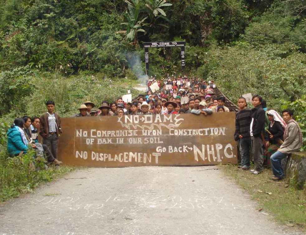
PROJECT UNABLE TO SUBMIT SATISFACTORY PROPOSAL EVEN SIX YEARS AFTER PM LAID FOUNDATION STONE!
In a remarkable decision, the Forest Advisory Committee (FAC) of MoEF has rejected the forest clearance to 3000 MW Dibang multipurpose project for the second time in its meeting held on 29 -30 April 2014. In that meeting FAC considered the Dibang multipurpose project for diversion of massive 4577.84 ha of biodiversity rich forest land which would lead to cutting down of huge 3.24 lac trees.
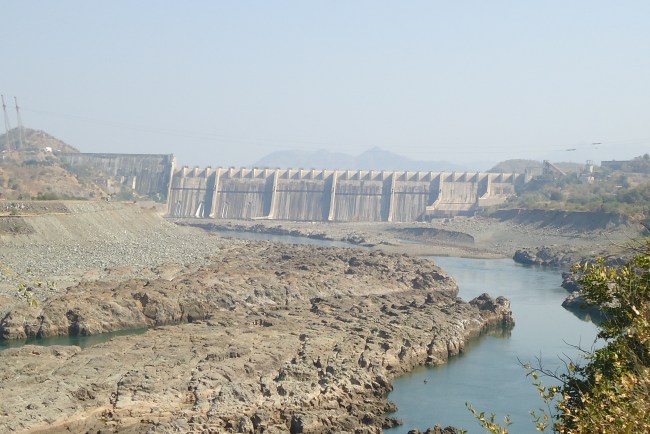
The latest (March 2014) edition of the National Register of Large Dams[1] (NRLD) from Government of India’s premier Technical organisation, Central Water Commission (CWC) seems to be giving information about Uttarakhand dams that seems in violation of Environment Protection Act, EIA notification, Forest Conservation Act and Wildlife protection Act. The CWC’s NRLD is also in violation of the Supreme Court of India orders of Aug 13, 2013, the apex court is still seized of this issue. The NRLD is showing several dams like Rambara and Bogudiyar Sirkari Bhyol (BSB for short) as under construction projects, when these projects have received none of the statutory clearances. These projects were absent in the previous (Dec 2013) edition of the NRLD (available with SANDRP), which means these have been added only earlier this year, after the Uttarakhand flood disaster of June 2013 and after the Supreme Court order of Aug 13, 2013. Both CWC (as publisher of NRLD) and Uttarakhand government (as provider of such information) are guilty.
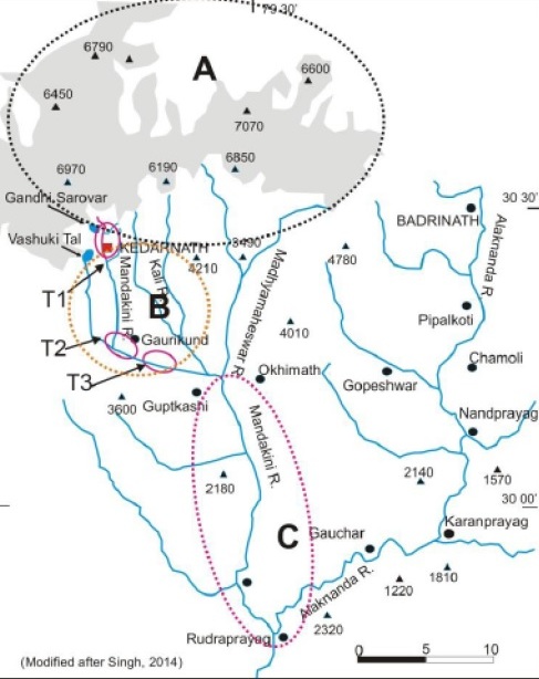
Rambara HEP A 76 MW Rambara HEP on Mandakini river in Rudraprayag district had come before the Union Ministry of Environment and Forests’ Expert Appraisal Committee on River Valley Projects during its meeting in Oct 2008. Just 6 km downstream of the worst affected Kedarnath pilgrim centre, the Rambara town and project site has been completely washed out in the Uttarakhand flood of June 2013. Let us see the important decisions about this project over the years.
Þ Oct 2008 The EAC had than noted that the project is inside the Kedarnath Musk Deer Sanctuary and cannot be given even pre construction (stage I) clearance without an approval from the Supreme Court of India. The project never went back to EAC after that.
Þ 2012 In 2012, Wildlife Institute of India (WII) recommended, in a commissioned by MoEF following an earlier Supreme Court order, that this project, (by now the installed capacity has been reduced to 24 MW, but height of the dam goes up from 28 m to 31 m) be cancelled as its zone of influence coincides with the Kedarnath Wildlife Sanctuary. This was one of he 24 projects that WII recommended for cancellation.
Þ Aug 13, 2013 Following the Uttarakhand disaster of June 2013, the Supreme Court order of 13.08.2013 asked the MoEF to take a view on this recommendation of WII. Following the apex court order, MoEF appointed an Expert Body (EB) under the chairmanship of Dr Ravi Chopra.
Þ April 16, 2014 The EB report[2] recommends that Rambara, along with 22 other projects be dropped, as recommended by WII.
Þ May 7, 2014 Supreme Court orders stoppage of work on the 24 projects that WII had said should be cancelled. This includes Rambara HEP.
While all this is going on, the new NRLD just published by the CWC suddenly shows Rambara dam as under construction dam. When seen in conjunction with the pro hydro lobbying report submitted by CWC-CEA to the MoEF, it is clear that the CWC is trying to bypass the whole Supreme Court ordered process and also attempting to push projects in violation of the process.
Bogudiyar Sirkari Bhyol HEP This 170 MW dam on Goriganga River (tributary of Kali River) in Pithoragarh district in Uttarakhand had come before the EAC for stage I clearance in May 2009. The MoEF website[3] lists this project as awaiting TOR even today. So this project has no environment or forest clearance, no CEA clearance, no EIA-EMP, no public consultations or environmental appraisal, and construction on the project without these would clearly be illegal. However, CWC’s NRLD (March 2014 edition) shows this project too as under construction. This is a massive 98 m high dam on a river that faced the flood disaster in June 2013 and NHPC’s 280 MW Dhauliganga HEP on Kali river faced such destruction[4] that it has still to be repaired. As per the EB report, there is need for a cumulative impact assessment in Goriganga / Kali River, which has not even been initiated.
Lakhwar Dam & Vyasi HEP The CWC’s NRLD also shows the 300 MW Lakhwar storage dam on Yamuna River in Uttarakhand under construction. This biggest dam in whole of Yamuna valley in Uttarakhand has had no EIA-EMP, no public consultations, no Environmental appraisal. The Uttarakhand government and MoEF are guilty of giving forest clearance to the Lakhwar project and downstream 120 MW Vyasi HEP and initiating work on these projects (no work has happened on these projects for over two decades) even as the Supreme Court stay on no clearances was on. Even EB report has mentioned these violations and application on contempt of SC order is pending before the Supreme Court. To show Lakhwar and Vyasi projects as under construction in the CWC’s latest edition of NRLD is clearly wrong.
Other problems with CWC’s NRLD We have in the past pointed out several other issues with CWC’s NRLD[5], including case of missing river names, missing dams and so on. CWC needs to be much more careful about information given in such an important document like NRLD.
CWC cannot act like a post office In the past, when such issues about information in NRLD have been raised with CWC, it has said that NRLD is only a compilation of information provided by states and only states are responsible for the correctness of information. However, CWC is India’s premier technical body on water resources and is also the national body in charge of safety of dams. Under the circumstances, on the issue of information about dams in NRLD, CWC cannot wash its hands and say it is only posting information given by states. In this particular case of Uttarakhand dams, CWC and Uttarakhand government both are responsible for the illegalities involved, as highlighted earlier.
It seems we do not want to learn any lessons from the massive Uttarakhand disaster of June 2013. Two more huge capacity hydropower projects have been submitted to the Expert Appraisal Committee (EAC) of Ministry of Environment & Forest (MoEF) for grant of Environmental Clearance (EC) with very poor quality Environmental and Social Impact Assessment (EIA) reports.
EIA reports of Kiru Hydro Electric Project (HEP) (660MW) and Kwar HEP (560 MW) proposed in Kishtwar district, Jammu and Kashmir by Chenab Valley Power Projects Ltd. (CVPP) were submitted to the EAC for River for its 74th meeting held on 5-6 May, 2014 for grant of EC. The projects are run-of-river schemes proposed on river Chenab as a part of cascade development of Chenab basin.
Vicinity Map(Source Kiru EIA Report)
Partial Map of Commissioned and Proposed HEPs in Chenab River Basin (Map by SANDRP)
Chenab basin may have one of the highest concentrations of hydropower projects among all basins in India[1]. The basin has over 60 HEPs under various stages of planning, construction and commissioning in states of Himachal Pradesh (HP) and Jammu and Kashmir (J&K).
While 49 of these projects are planned or under construction in Chenab in HP, 28 projects of combined generation capacity of 5,800 MW are at an advanced stage of obtaining (Environment Ministry) clearances[2]. State of J&K has 13 projects planned of total capacity 8,623 to 8,923 MW. These consist of at least four operational projects (of total 1563.8 MW), three under construction projects (of 1450.5 MW) and six proposed projects (of 5608.7 MW).
Table 1: Cascade Development of Chenab Basin
Source: EIA report of Kiru & Kwar
Sr. No.
Scheme
River
Capacity
1
Salal (Stage- I & II)
Chenab
690 MW
2
Sawalkot
Chenab
1856 MW
3
Baglhar (Stage-I & II)
Chenab
900 MW
4
Shamnot
Chenab
370 MW
5
Ratle
Chenab
850 MW
6
Dulhasti
Chenab
390 MW
7
Kwar
Chenab
560 MW
8
Kiru
Chenab
660 MW
9
Kirthai-I
Chenab
350 MW
10
Kirthai-II
Chenab
990 MW
11
Barinium
Chenab
240 MW
Himalayan ecosystem, of which the Chenab river basin is a part, is known to be geologically fragile. Cascade of hydel projects proposed on the river basins of this region would make the region even more vulnerable to extreme and erratic weather events, which will increase in changing climate. This has already been witnessed during Uttarakhand disaster of June 2013. Expert Body (EB) headed by Dr Ravi Chopra recently has officially acknowledged this connection in the report submitted to MoEF[3]. In light of this, a thorough impact assessment of all the proposed hydro power projects in this region is thus of critical importance. Various organizations and experts including SANDRP have repeatedly highlighted the fact that Cumulative Impact Assessment (CIA) of all the proposed, under construction and operational projects and carrying capacity assessment (CCA) of the river basin to see if it can support the massive number of HEPs in safe and sustainable way is one of the first steps before considering clearances to HEPs in this region. Without such a study, considering any hydropower project in the basin will be an invitation to disaster[4].
Even though the MoEF sanctioned TORs for cumulative impact assessments of the HEPs on Chenab in HP in February 2012, this critical task was entrusted to the Directorate of Energy, Government of Himachal Pradesh. This is a clear case of conflict of interest. Further the project specific ECs were delinked from the CIAs[5].
More importantly, no such study has been initiated in Chenab basin in J&K or in the Chenab basin as a whole. State of Jammu and Kashmir is not even considering CIA of HEPs on Chenab in the state as MoEF has not asked for it yet. CIA of the entire Chenab basin including HP and J&K is not being considered, which itself is violating MoEFs Office Memorandum dated May 28 2013. The OM states that all states were to initiate carrying capacity studies within three months from the date of the OM No. J-11013/I/2013-IA-I. Since this has not happened in case of Chanab basin in J&K, considering any more projects in the basin for Environmental clearance will be in violation of the MoEF OM.
On Cumulative Impact Assessment, the OM said, “While, first project in a basin could come up without insisting on cumulative impact study, for all subsequent hydro-power projects in the basin, it should be incumbent on the developer of second/ other project(s) to incorporate all possible and potential impacts of the other project (s) in the basin to get a cumulative impact assessment done.” The EIA of both the projects does not include the cumulative impacts.
MoEF continues to give clearances to individual HEP projects despite of poor quality Project Feasibility Reports (PFRs) and EIA reports submitted for appraisal. Kiru & Kwar EIA reports are a classic example of such poorly conducted EIAs. The EIAs demonstrate several serious issues across various stages from TOR non-compliance, non assessment of impacts, cut and paste job, lack of any references, faulty public hearings, the issued raised at public hearings have not been addressed in EIAs, as statutorily required. SANDRP recently made detailed submissions to EAC highlighting these issues for both the projects. Some highlights below:
Copy paste job while preparing EIA reports Both the reports are prepared by a consortium of RS Envirolink Technologies Pvt. Ltd. (Gurgaon) and Jammu University. Kiru EIA report demonstrates a casual approach towards impact prediction and proposing mitigation measures in EMP. The report also misses out on a number of important aspects of EIA like impact of construction activities on geology, flora fauna, impact of climate change, cumulative impacts of cascade development in Chenab basin etc. While Kiru EIA is inadequate on several fronts it was utterly shocking to discover that Kwar EIA report is a complete replica of the Kiru EIA Report. Entire text, save project specific numbers, remains the same in both reports, to the extent that the Kwar EIA report mentions Kiru instead of Kwar at several places!! The impact prediction for both the cases is so vague and generic that the changes in numbers for project-specific details like proposed installed capacity, submergence of reservoir, FRL, head race tunnels etc. do not reflect at all in the reports!
Brief Project Profiles Kiru H.E. Project and Kwar H.E. Project are run-of-river schemes proposed on river Chenab located in the district Kishtwar of J&K.
Kiru HEP envisages the construction of a 193 m long and 123 m high concrete gravity dam above the river bed across river Chenab at village Kiru with four intake, four pressure shafts, an underground powerhouse of 4 units of 165 MW each. Impoundment will cover an area of 1.03 Km extending 6.5 km upstream of dam. The average river bed level at the dam site is about EL 1394 m corresponding to an FRL of 1515 m, the gross storage of the reservoir is 41.50 Mcum and area under submergence is 1.03 Km.
Proposed dam site for Kiru HEP(Source Kiru EIA Report)
Kwar HEP envisages construction of a concrete gravity dam 101 m high from river bed across river Chenab at village Padyarna, four number intakes, four pressure shafts, an underground powerhouse to accommodate 4 units of 140 MW each and two number tail race tunnel. FRL of reservoir is proposed at EI 1385M. Gross storage of the reservoir at FRL is 27.167 Mcum. The reservoir will submerge an area of about 0.8 Sq. Km at FRL.
Proposed dam site for Kwar HEP (Source Kwar EIA Report)
TOR non-compliance First and foremost glaring issue about the proposed projects is the non-compliance with the TORs (Terms of Reference) laid down for conducting the EIA. These TORs were granted by MoEF. We have listed here only an indicative list of non compliance below, not an exhaustive one.
Kiru HEP The TOR clearance letter was issued for Kiru project on Sept 9, 2008, the TORs are valid for a period of 3 years, but the project developer never came back for extension of the TOR on expiry of 3 year period and has come now for EC over 5.5 years after the TOR clearance. Thus the TOR clearance is no longer valid for Kiru HEP as per the law. Also originally the TOR clearance for Kiru was given for 600 MW installed capacity. The EIA however has been conducted for 660 MW capacity. No permission was sought by the PP for this increased capacity.
Kwar project has undergone several changes since the grant of TOR on 17 March 2010. Table given below compares some of these changes. First and foremost alteration has been in the proposed total power generation. While the TORs were granted for 520 MW the EIA has been conducted for 560 MW. Number of affected families goes up by 160% and project cost escalates by 29%. The TORs were granted for over four years back and the project authority never got back to EAC/MoEF for renewal of the TOR as other projects do. Thus the TORs granted originally do not remain valid in this case too.
Table 2: Changes in the scope of Kwar project after grant of TOR on 17 March 2010
Sr. No.
Parameter
Scope at the time of TOR clearance
Current scope of the Proposed Project
1
Total power Generation
520MW
560 MW
2
Land requirement
5 Ha Government land
93.66 Ha Government land
3
Power House Units
4 x 130 MW
(4 x 140MW)
4
Affected families
35
91
5
Project Cost
Rs 3386.11 Cr
Rs. 4375.50 Crores at Jan’2012 PL
Casual approach towards impact prediction
Kwar EIA copy pasted from Kiru EIA report: It is evident that the EIA consultants have done nothing but copy paste job while preparing Kwar EIA report. At certain places Kwar report mentions ‘Kiru’ instead of Kwar. See for example point number 1.7 in Index of Kwar EIA mentions ‘Need of the Kiru HE project’instead of Kwar and point number 4.4 mentions ‘Basin characteristics of free draining area of Kiru HEP’ (p.3 & p.6 of the document). Page 28 of Kwar EIA states that “The case for forest clearance of Kiru HE Project for diversion of 29.75 ha of forest land has been approved in the 81st meeting of J&K State Forest Advisory Committee (FAC) held on 09.12.2013…”
Other than very project specific figures, the entire text for both the reports is exactly the same. Impact prediction is the heart of an EIA study. However in Kwar EIA report an important chapter like Chapter 8- “Identification, Prediction and Evaluation of Environmental Impacts” is also copy pasted. The text of the chapter is same as that of Chapter 8 from Kiru EIA report save the project specific numbers and their description. The impacts predicted are vague and are conveniently kept the same in both the reports. It is clear that no real field work or application of mind is done. Such an EIA study defeats the basic purpose of conducting an EIA.
Impact of construction activities: The Kiru project involves a reservoir of live storage 10.5 MCM, a concrete dam on height (from river bed) 123.0 M & length 193 M, construction of 4 head race tunnels (of 7 m dia and 165 to 190 m length each) for discharging the water to an underground powerhouse of 4 units of 165 MW each. The project also envisages 33.4 Lakh CuM of construction material required from the project site.
The Kwar project involves construction of 101 m (above river bed)/ 109 m (above deepest foundation) high concrete gravity dam, Underground power house complex of four units of 140 MW each, Two concrete lined 9.5 m internal diameter main tailrace tunnels (having length of 2676 m and 2883 m) amongst several other features like four 5.65 m internal diameter main pressure shafts (each with a length of 108-182 m), etc. The project also envisages 38.36 Lakh CuM of construction material required from the project site.
View of Naigarh Nala Rock Quarry at Kwar Dam site (Source Kwar EIA Report)
All these activities will have significant impact on the geology and hydrology of the region. However no significant assessment or quantification of these impacts in terms of change in drainage patterns, springs in the project area, increased thereat of landslides, seismic activities has been carried out.
While talking about the impact of construction activities, the only impact of these two EIAs discussed in the chapter is ‘muck generation’. It does not mention impacts of tunneling and blasting involved in construction and also does not talk about its impact on fragile geology and hydrology of Himalayan region at all[6]. While talking about quarrying activities in the same chapter it states only two impacts viz. visual impacts and noise generation[7]. Impacts on landslides have been randomly dismissed stating that the sliding activity may not be significantly induced by project construction activities[8]. The reports trivialize the impacts on migratory fish Mahseer by stating that the upstream migration of this fish from the lower reached of the Chenab River have already been blocked by Salal and Baglihar, Dul Hasti dams. Thus they conclude that impact of this project on this fish species is not expected to be significant[9]. Option for fish ladder and fish lift has been ruled out for both the projects stating that it is not techno-economically feasible at the project site. Development of a hatchery at the project site has been proposed instead. The impact of the project on all the fish available in the river should have been assessed based on baseline assessment of the fisheries in Chenab River, which is not done. Secondly, there is no credible evidence to show that hatchery as a management option is useful or effective.
Left Bank slide for Kiru Project downstream of Ludrari Nala (Source Kiru EIA Report)
Right Bank slide for Kiru Project about 16 km downstream of Gulab Gargh (Source Kiru EIA Report)
The southern boundary of the Kishtwar National Park is approximately at an aerial distance of 11 km away from the proposed project, it is claimed, but this needs to be independently assessed. Also, just because it lies outside the boundary of study area which is radius of 10 KM, the EIA does not consider the impacts on this national park at all! EIA reports for both Kiru and Kwar HEPs simply state that the proposed activities shall have no impact on the National park[10].
Biodiversity at Kishtwar National Park (Photo: Travel Places[11] & Beauty Spots of India[12])
Several Important aspects of EIA are missing
No mention of free flowing river stretch: There is no mention of what is the flowing river stretch upstream and downstream of the project. As is clear from the EIA, the elevation difference between FRL of Kiru HEP (1515 m) and TWL of upstream Kirthan II (1526.5 m) is just 11.5 m. The elevation difference between TWL of Kiru HEP (1388 m) and FRL of downstream Kwar HEP (1385 m) is just 3 m. Similarly the elevation difference between TWL of Kwar HEP (1270 m) and FRL of downstream Hasti HEP (1264 m) is just 6 m. However, it is not clear what the flowing river lengths in all these locations are. Unless this length is assessed and is found to be adequate for river to regain its vitality, the project should not be considered and it should be asked to change the parameters.
Environmental Flows: The Kiru EIA report states that significant downstream impacts related to the water quality, fisheries, socio-economic and aquatic biodiversity are not foreseen since toe power house is proposed downstream of the dam and tail water level is EL 1388.52 m, discharge will be less only in a “very small stretch of about 800 m”. This seems to show the ignorance of the EIA consultants about how biodiversity in a flowing, lively river like Chenab survives.
Kwar EIA report states that the water entering the reservoir will be released back to river at a distance of 2.6 KM downstream. The report claims that though there in no human activity in this stretch of 2.6 KM the aquatic life will be definitely affected, as also terrestrial biodiversity, groundwater recharge, use of river and silt flow pattern.
10% of average of lean season discharge has been prescribed to be released through the dam gates as environmental flow for both the projects. This quantity has been calculated as 9.0 cumecs based on discharge data of the river. There is no mention of environmental flows in EMP. Firstly, this is even below the norms being followed by EAC and MoEF (30% in monsoon, 20% in lean season and 25% in rest, each at 90% dependability). Secondly, the amount of E-flow required needs to be arrived at based on actual assessment, but no such assessment has been done.
Impact of peaking generation not assessed: The reports talk about advantage of hydropower in terms of ability to providing peaking power. However, when a project operates as peaking station, there are severe impacts in the downstream and also upstream (rim stability). These impacts have not been assessed, nor is it assessed how the project will perform in the cascade development it is in.
Some other important aspects of impact assessment that report misses out on are:
Impact of the project on disaster potential in the project area as well in the downstream due to construction and also operation at various stages, say on landslides, flash floods, etc.
Social and Environmental Impacts of construction and operation of the coffer dams and diversion tunnels during construction phase are not included.
The reports do not even mention Climate Change.Impact of climate change on the project and impact of the project on the local climate has not been assessed. No mention or attempt has been made about or to assess the impact of green house gas emissions from the project.
Impacts on the flood characters of the river due to this dam, what will be the changes and how these will impact downstream areas.
Impact of changing silt flows downstream from desilting chamber and from silt flushing in monsoon on the downstream areas not analyzed. A detail account of how the silt from the dam would be flushed out annually and what would be the impact of this in the downstream as well as on the geo morphology, erosion, stability of structures etc was not done.
Options Assessment is missing, this is crucial part of the EIA to establish that among all options, including non project option, the given option is the least cost and best option.
Cumulative Impacts not assessed The EIA report gives list of Major hydroelectric projects executed /under execution/ under investigation so far in the basin in J&K which are a part of Cascade Development. Kirthan HE Project (990MW with proposed FRL at 1764 m and TWL at 1526.50m) which is yet to be commissioned is proposed upstream of Kiru (660 MW with FRL at 1515M). Downstream of Kiru is Kwar HE Project (560 MW with FRL at 1385 m and TWL at 1270 m) which is yet to be appraised and Dul Hasti HE Project (390 MW with FRL at 1264 m) which is commissioned.
Impoundment of Chenab at Dul Site (Source: Kwar EIA Report)
Moreover, the EIA does not provide the list of hydropower projects being taken up in Chenab basin in upstream Himachal Pradesh[13]. The cumulative impacts of all such projects will be huge.
The report summarizes cumulative impacts in single sentence: “The increased pressure will include uncontrolled logging, hunting of wildlife, non-timber forest product collection, livestock husbandry, the cultivation in forest areas and forest fires.”[14]
EIA report completely misses out on the detailed analysis of cumulative impacts in terms of
Impacts on flora, fauna, carrying capacity, livelihoods
Impact of reduction in adaptive capacity of the people and area to disasters in normal circumstance AND with climate change
Impacts on springs and drainage pattern
Disaster potential of the area
Tunneling and blasting
Geological disturbance caused
Seismic impacts
Carrying capacity
Inadequate Dam Break AnalysisThe Dam break analysis does not take into account the cumulative disaster potential including existing and proposed upstream and downstream projects. The EIA report also does not include cumulative disaster management plan.
Improper Public Hearing Public hearing conducted for both the projects were flawed. Excerpts from the speeches made by the officials from J&K State Pollution Control Board (SPCB) and CVPP that are noted in the public hearing report show that what these persons spoke was inappropriate, misleading and intimidating[15]. Also point wise responses to the issues raised by people at the Public Hearing are not provided in the EIA, as statutorily required. Hence even when people ask for Resettlement and Rehabilitation as per latest Act of 2013 (made effective from Jan 1, 2014), the EIA talks about National Resettlement and Rehabilitation Policy of 2007. The public hearing report strangely end for both projects with the officials asking those who are for the projects to raise their hands. There is no formal provision for voting for or against the project. Such public hearing should be declared null and void and fresh public hearing should be conducted.
Poor quality EIA reports that reflect pro hydro bias of the consultant EIA is the most effective tool to ensure environmental compliance in India. Needless to state that it is of critical importance. Casually predicted, unaddressed impacts and copy paste job of the Kiru and Kwar EIA reports once again highlights the poor quality of EIA reports submitted to the ministry for grant of EC. These reports decide fate of the project, of the people and environment surrounding the project site. Such quality of the report is most definitely not acceptable.
Further, an EIA report is an attempt to understand what are the adverse social and environmental impacts of a project and weather the impacts are acceptable, if the project is viable, optimal and desirable. The answer to this exercise can also include the answer that the project is not viable or desirable or acceptable. In view of this, the EIA consultant needs to be completely unbiased and should be ready to even conclude that the project is unacceptable. However, in case of the EIA consultant for the Kiru & Kwar HEP, EIA starts in very 1st chapter with a shockingly unscientific and biased statement: “Hydropower projects are dependable, renewable, economic, environmentally benign sources of energy with ability to stop and start instantaneously.” This statement is factually wrong on many counts (e.g. hydropower project is renewable or dependable or environmentally benign source of energy). It, along with whole para 1.2 also reflects the bias of the EIA consultants RS Envirolink Technologies Pvt Ltd (with Jammu University) and we urge the EAC and MoEF to reject such poor quality and biased EIAs and take other necessary steps to debar such agencies from doing any EIA or environmental studies in future.
CONCLUSION Looking at serious issues above, based on merit of the EIA reports, as well as complete cut-paste jobs, we are hopeful that the MoEF will not recommend EC for these projects. This case also highlights the importance of cumulative impact assessment in an over developed Himalayan basin. When the experience with Uttarakhand flood disaster of June 2013 is fresh, we hope that MoEF will not commit another blunder.
[15]The Public hearing report of Kiru says that Shri Sajjad Mufti, Regional Director of J&K SPCB said at the public hearing, “Construction of project should not deteriorate the environment….” This is a very strange, untruthful and inappropriate statement from J&K SPCB official. Why should the official be speaking at all at the public hearing and that too make such a statement that would also affect the atmosphere of the public hearing? Similarly the statement of GM of CVPP at the public hearing, “The most viable and cleanest of all (sources of power) is hydro power” was again, wrong, intimidating and inappropriate. The statement of Shri Khursheed Ahmed Butt of CVPP, “forest clearance has already been granted to the proposed project” is incorrect since the proposal for forest clearance for the project has not even come before FAC. Such public hearing should be declared null and void and fresh public hearing should be conducted.
The Public hearing report of Kwar says that the GM of CVPP said at the public hearing, “The best source of power generation is hydro power” was wrong, intimidating and inappropriate. The statement, “forest clearance has already been granted to the proposed project” is incorrect since the proposal for forest clearance for the project has not even come before FAC.
“We enjoy Pushing Rivers Around” –An early Hydraulic engineer in California (from Patrick McCully’s Silenced Rivers, 1996)
“We can tame the mighty rivers. We are an example of human will and endeavor”
-Sutlej Jal Viduyt Nigam Limited, damming the entire Satluj Basin in India.
“A river flowing to the sea is a waste”- a view held by several water resource developers in India
Welcome to Anthropocene [1],says James Syvitski, a leading oceanographer, geologist and hydrologist from Colorado University who has been studying subsidence of deltas.
Some scientists are now placing Anthropocene, an era marked with human interference with natural systems, at par with geological epochs like Pleistocene and Holocene. It is manifested in many ways. Rivers and associated systems like deltas and floodplains possibly have had to face the maximum brunt of the Anthropocene.
Cutting edge scientists like Prof. Syvitski who study the changes in our deltaic systems seem to reach to a common conclusion: Delta subsidence is now the main driving force for effective sea level rise for many coastal environments. This subsidence is more influential than sea level rise related to global warming and any deltas are sinking much faster than the sea level is rising.
But why are deltas sinking? What is the main reason behind this subsidence which is eating away land and making millions of people more vulnerable?
It has been established that the main reason behind delta subsidence is drastically reducing sediments reaching the delta.Studies estimate that during the past century, there has been a 94% reduction in Krishna’s sediment reaching the delta, 95% reduction from historic load in Narmada, 80% reduction in Indus, 80% reduction in Cauvery, 96% reduction in Sabarmati, 74% reduction in Mahanadi, 74% reduction in Godavari, 50% reduction Brahmani, etc.[2],[3]
But why are sediments not reaching the delta?
Almost unanimous agreement between scientists indicates that the reason behind this drastic decline in sediments is sediment retention by dams and reservoirs in the upstream[4].(Walling and Fang (2003), Vörösmarty et al., 2003; Syvitski et al.,(2005), Erisson et al, (2005), Walling (2008), K Rao et al (2010), H Gupta et al (2012) ). This has been reiterated in IPCC WG II Report, April 2014.[5]
Bhola Island in Bangladesh, eroded by Meghana River. PhotoSrestha Banerjee, Green Clearance Watch
Prof. Syvitski wrote a few words on the issue for SANDRP. He says, “A delta can form only where the sediment volume supplied from a river can overwhelm the local ocean energy (waves, tides, currents). Ocean energy is ceaseless. Engineering of our river systems, largely through the construction of upstream dams and barrages, has reduced this sediment supply. Consequently ocean energy has begun to reduce the size of our deltas, and coastal retreat is presently widespread. Deltas, once the cradle of modern civilizations, are now under threat — some deltas are in peril of lasting only the next 100 years. Sea level is rising due to ocean warming and glacier melting. Incessant mining of groundwater from below a delta’s surface, along with oil and gas extraction, further contribute to our disappearing deltas. At risk are the residences of more than 500 million people, the loss of biodiversity hotspots, major infrastructure (e.g. megacities, ports), and the rice and protein bowls of the world. Every year thousands of people drown due to storm surges and other coastal flooding. Sinking deltas are evidence of the magnitude of the human footprint on our planetary environment. We must learn to do better.” Professor J P Syvitski (U Colorado, Boulder, USA), Chair — International Geosphere-Biosphere Programme (ICSU), Executive Director, the Community Surface Dynamics Modeling System
Large reservoirs trap as much as 80% of the upstream silt. As a result, most rivers are carrying much less sediment, and some rivers (like Krishna, Indus, Nile, and Colorado) transport virtually no sediment! In the last 50 years, the combined annual sediment flux of the large Chinese rivers has been reduced from 1800 million tons (Mt) to about 370 Mt[6]mainly due to frenzied dam building. The impact of dams and reservoirs on sediment retention has been so significant that the resultant reduced sediment load represents a volume of about 730 km3, equivalent to an area of 7300 km2 assuming a 10 m thick bed[7]. Waling (2008) states that about 25 Gt/year of sediment are trapped by large dams each year. IPCC Report (Assessment Report 5, 2014) refers that 34 rivers with drainage basins of 19 million km2 in total show a 75% reduction in sediment discharge over the past 50 years due to reservoir trapping.
Delta Subsidence and Effective Sea Level Rise (ESLR)
While this delta subsidence and sediment retention has several impacts on dense delta population and coastal ecosystems which offer important services, one of the most serious impacts is its direct role in Effective Sea Level Rise. Ericsson and Vorosmarty et al, 2012[8], concluded that decreased accretion of fluvial sediment resulting from sediment retention and consumptive losses of runoff from irrigation (also due to dams) are the primary determinants of ESLR in nearly 70% of studied deltas.
More and more scientists are concluding that climate related sea level rise has a ‘relatively minor influence on delta conditions’, as compared to anthropogenic reasons. As seen above, there is an almost unanimous agreement that dams are the most important factor influencing contemporary land-ocean sediment fluxes.[9] Globally, greater than 50% of basin-scale sediment flux in regulated basins is potentially trapped in artificial impoundments of approximately 45,000 reservoirs (with dams 15 m high) (Vörösmarty et al., 2003; Syvitski etal., 2005) and sediment delivery to deltas has been reduced or eliminated at all scales.[10]Other reasons for delta subsidence include flow diversion by dams, sediment compaction due to groundwater abstraction, oil and gas exploration and mining, etc,.[11]
Deltas, formed by centuries of accretion of rich sediment, are one of the most fertile and densest populated regions across the world. It is estimated that close to half a billion people live on or near deltas, often in megacities.[12] Although constituting a mere 5% of the total landmass, coastal regions sustain almost three-quarters of the world’s population and yield more than half of global gross domestic product (Vorosmarty et al.,2009).
The direct impacts of ESLR and delta subsidence include inundation of coastal areas, saltwater intrusion into coastal aquifers, increased rates of coastal erosion, an increased exposure to storm surges, etc. These threats have implications for hundreds of millions of people who inhabit the deltaic as well as the ecologically sensitive and important coastal wetland and mangrove forests.
Already, some studies are ringing alarm bells. It is estimated that if no mitigation measures are undertaken and sediment retention continues, then by 2050, more than 8.7 million people and 28,000 km2 of deltaic area in 33 deltas studied including Ganga-Brahmaputra, Indus, Krishna and Godavari could suffer from enhanced inundation and increased coastal erosion. In addition, a larger population and area will be affected due to increased flood risk due to storm surges[13]. Conservative estimates state that delta area vulnerable to flooding could increase by 50% under the current projected values for sea-level rise in the 21st century and this could increase if the capture of sediment upstream persists and continues to prevent the growth of the deltas.[14]
The Intergovernmental Panel on Climate Change (IPCC) projects that sea level will rise by another 21 to 71 cm by 2070, with a best estimate of 44 cm averaged globally. This will further compound impacts of delta subsidence and sediment trapping.
It has been estimated that even in the case of debilitating floods, sediment has not reached rivers in the deltas.[15]In 2007–08 alone Ganges, Mekong, Irrawaddy, Chao Phraya, Brahmani, Mahanadi, Krishna and Godavari flooded with more than 100,000 lives lost and more than a million habitants displaced. Most of the deltas that suffered from floods did not receive a significant input of sediment, and this lack of sediment can be attributed to upstream damming.[16] Some studies demonstrate that storage of sediment-laden water of major flood events leads to huge sediment trapping behind mega dams.[17]
Above: Global distribution of ESLR under baseline for each of the 40 deltas studied by Ericsson et al, 2006.From Ericsson et al, 2006
Fluvial Sediments and Deltas in India
Rivers are not only conduits of water. They are a complex, moving systems carrying sediment, nutrients, organisms, ecosystems, energy, material and cultures in their wake.
There are three kinds of sediments: suspended, bed load and wash load. Here we are referring to mainly the suspended sediments in the rivers. Sediments play a significant role in the river geomorphology, defining the river channel, its shape and structure. Sediment deposits form alluvial floodplains, deltas, levees, beaches, ox bow lakes and lagoons and creeks. The sediment load and composition changes according to the river, the geological landscape it flows in, its length, flow, structure, etc. While much of the sediment is deposited by the river on its banks, the delta of the river is primarily formed of rich sediments. Through this deposition, the river may form distributaries at its mouth, like in case of Ganga, Brahmaputra or Mahanadi systems. Ganga-Brahmaputra Delta, shared by India and Bangladesh is one of the largest delta systems in the world, spanning more than 100,000 km2[18]carrying more than one billion tonnes of sediments annually.[19]
Deltaic populations in shared rivers of India, Bangladesh and Pakistan: Population of Ganga-Brahmaputra-Meghana Delta is more than 147 million people with a population density of more than 200 people per km2 (520 people per square mile), making it one of the most densely populated regions in the world . The Krishna Godavari twin deltas supports 9·26 million people inhabiting the 12,700 km2 area at 729 persons per km2, which is more than double the country’s average.[20] Cauvery delta supports 4.4 million people[21] while the Mahanadi Delta too supports millions. Only two districts of Cuttack and Jagatsinghpur have a population more than 3.7 million. (Census 2011) in addition, the contribution of deltas to economics, food production, transport, ecosystem services etc., is immense, making it a very valuable ecosystem which deserves protection. Indus Delta in Pakistan supports more than 900,000 people.
Deltas in Peril: Impact of damming on deltas in India
1. Krishna-Godavari Delta: In 2010, a team led by K Nageswar Rao of Dept of Geo Engineering, Andhra University, carried out an assessment of the impacts of impoundments on delta shoreline recession in Krishna and Godavari Delta.[22] The study revealed a net erosion of 76 km2 of area along the entire 336-km-long twin delta coast during the 43 years between 1965–2008 with a progressively increasing rate from 1·39 km2 per year 1965 and 1990, to 2·32 km2 per year during 1990–2000 and more or less sustained at 2·25 km2 per year during 2000–2008.
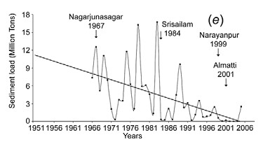
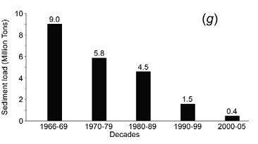
For Krishna, flows as well as suspended sediments in the delta have nearly reached zero. Suspended sediment loads decreased from 9 million tons during 1966–1969 to negligible 0·4 million tons by 2000–2005. Syvitski et al in their 2009 assessment place Krishna in the category of “Deltas in Greater Peril: Virtually no aggradation and/or very high accelerated compaction.”
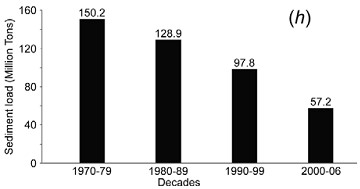
In the case of the Godavari delta, there has been almost a three-fold reduction in suspended sediment loads from 150·2 million tons during 1970–1979 to 57·2 million tons by 2000–2006. Syvistki et al classify Godavari delta as “Deltas in greater risk: reduction in aggradation where rates no longer exceed relative sea-level rise”. H Gupta et al (2012) suggest that decline in historic sediments of Godavari post damming has been as high as 74%.
Above: Graph indicating decadal sediment and water flow trends at Prakassam Barrage, across Krishna. Dam building also marked. From Rao et al, 2010
According to Dr. Rao, a comparison of data on annual sediment loads recorded along the Krishna and Godavari Rivers shows consistently lower sediment quantities at the locations downstream of dams than at their upstream counterparts, holding dams responsible for sediment retention. Reports based on bathymetric surveys reveal considerable reduction in the storage capacities of reservoirs behind such dams. Authors say: “Sediment retention at the dams is the main reason for the pronounced coastal erosion along the Krishna and Godavari deltas during the past four decades, which is coeval[23] to the hectic dam construction activity in these river basins.”
Impacts of this can be seen in destroyed villages like Uppada in Godavari delta, destruction of Mangrove forests and shoreline. Similarly Krishna delta is losing land at the rate of 82·5 ha per year, leading to destruction of mangrove forests and loss of land.
The study concludes: “If the situation continues, these deltaic regions, which presently sustain large populations might turn out to be even uninhabitable in future, considering conditions elsewhere, such as in southern Iraq, where the farmers downstream of dams across Tigris River in Iraq, Syria and Turkey are being forced to migrate to urban centres as the reduced river flows become overwhelmed by seawater.”
I talked with Dr. Rao and asked him, if his disturbing study had any impacts. He said, no one from the administration has contacted him ever about this issue.
Above: Sediments measured at Sir. Arthur Cotton Barrage across Godavari near the Delta from Rao et al, 2010
A similar study by IWMI[24] concludes: “Coastal erosion in the Krishna Delta progressed over the last 25 years (is) at the average rate of 77.6 ha/ yr, dominating the entire delta coastline and exceeding the deposition rate threefold. The retreat of the Krishna Delta may be explained primarily by the reduced river inflow to the delta (which is three times less at present than 50 years ago) and the associated reduction of sediment load. Both are invariably related to upstream reservoir storage development.”
Krishna Basin Water Disputes Tribunal Award, though mentions dam siltation (it mentions that in 5 decades, Tungabhadra Dam has silted up to 22% of its capacity), does not say anything about flow for flushing sediments or its importance to the delta in Andhra Pradesh, or if the “minimum instream flow” recommended by the Tribunal will address this issue. This is a major limitation of the tribunal, when advanced studies have been conducted on the Krishna River delta condition and its relation to upstream dams has been established beyond doubt. Only at one place does it mention that to reduce siltation of the Almatti Dam, sluice gates should be opened when water is flowing above the crest.
However, the Award states that issues like minimum in stream flows are not decided once for all and it is an evolving process. Let us hope that there is some space to address the issue of shrinking deltas through this.
Above:Decreasing Sediments of Krishna down the years from K Rao et al, 2010
In the upstream Maharashtra, more and more dams are under construction in the Krishna Godavari Basin. One of the proposed dams called Kikvi, at the headwaters of Godavari in Trimbakeshwar was cleared by the Forest Advisory Committee recently. Ironically, the proponent (Water Resources Department, Maharashtra and Nashik Municipal Corporation) justified this dam which will submerge more than 1000 hectares of land, by stating that one more large dam close to Kikvi: Gangapur Dam is heavily silted up. [25]Rather than desilting Gangapur Dam, the administration wants to build one more dam.
Above: Trends in Sediments in Godavari and dam building activity. From K Rao et al
Many dams in Krishna Godavari Basin in Maharashtra have been criticised for not contributing to increasing irrigation.[26]These dams are not only obstructing river flow, but are also acting as sediment traps. Unfortunately, the MoEF is not even considering impacts of sediments while appraising dams. In Karnataka, major projects are being undertaken by fraud, without environmental appraisal, violating Environment laws, [27]similarly in Andhra Pradesh, many projects are being pushed illegally without environmental appraisal and which involve huge corruption[28].
2. Cauvery Delta: Although detailed studies have not been carried out, there is a clear indication of salt water intrusion and delta erosion in this over developed basin, due to upstream dams. The saline-freshwater boundary map indicates a steady migration inland.
A study by Gupta et al, 2012, indicates that historical sediment flux of Cauvery was 1.59 million tonnes, which is now 0.32 million tonnes (average of 10 years) and hence, there is a whopping 80% reduction in sediment flux of the river.
Unfortunately, the Cauvery Water Disputes Award Tribunal between Karnataka and Tamilnadu does not even mention the word ‘sediment’ in its award. There has been no justification for 10 TMC feet (Thousand Million Cubic feet) water recommended by the Tribunal for Environmental purposes and its possible impact on sediment carrying (or even environment for that matter).
Pennar showed 77% reduction and Mahanadi showed 67% reduction in amount of silt reaching the delta in recent years. (Gupta et al, 2012)
3. Narmada Delta: The west flowing rivers like Narmada and Tapi do not form extensive deltas like the east flowing rivers. Nonetheless, sediments from a huge river like Narmada play an important part in the stability of Narmada delta and villages and ecosystems around it.
Above: From: H. Gupta et al, 2007 and 2012
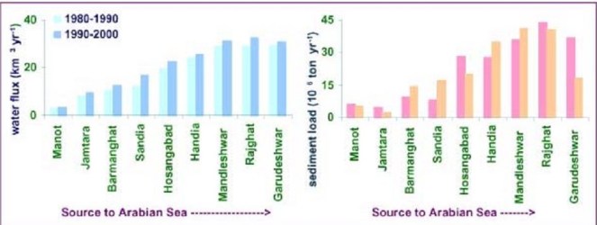
Gupta et al (2012 and 2007) assessed daily water discharge and suspended sediment load data measured by CWC at two gauging stations, one upstream of the Sardar Sarovar dam (Rajghat), and another downstream of the dam (Garudeshwar).
Historical sediment discharge of Narmada was found to be 61 million tonnes and the current sediment discharge (average of last ten years of the study) was found to be 3.23 million tonnes, indicating a reduction of 95% sediment discharge.[29] The presence of dam reduces 70–90% of coarse and approximately 50% of medium-sized particles on their way downstream, allowing them to settle in the reservoir Comparative studies of average suspended sediment load at various locations on the Narmada River for more than two decades, show overall reduction in suspended sediment load in the river.
The study indicated 96% reduction in suspended silt flux in Sabarmati, 41% reduction in Tapi and 68% in Mahi.
4. Ganga- Brahmaputra Delta: Different studies put different values for individual and combined sediment load of the Ganga Brahmaputra system, which carries one of the highest sediment loads in the world. According to Islam (1999)[30] Ganges and Brahmaputra rivers in Bangladesh transport 316 and 721 million tonnes of sediment annually. Of the total suspended sediment load (i.e. 1037 million tonnes) transported by these rivers, only 525 million tonnes (c. 51% of the total load) is delivered to the coastal area of Bangladesh and the remaining 512 million tonnes are deposited within the lower basin, offsetting the subsidence. Of the deposited load, about 289 million tonnes (about 28% of the total load) is deposited on the floodplains of these rivers. The remaining 223 million tonnes (about 21% of the total load) is deposited within the river channels, resulting in aggradation of the channel bed at an average rate of about 3.9 cm/yr sediment.
Across the 20th Century, Syvitski et al suggest about 30% reduction of silt load in the river system. Gupta et al [31] suggest that the observed decrease in sediment load could be due to construction of several mega dams in the Ganga basin, closure of Farakka barrage (1974) and diversion of sediments laden water into the Hooghly distributary. They also caution that dams in Ganga and Brahmaputra can worsen the situation.
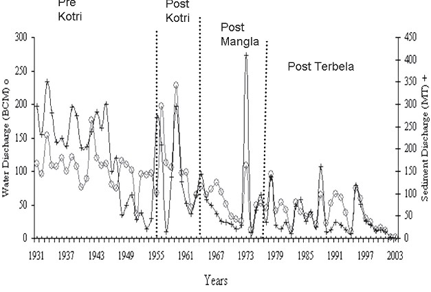
5. Indus Delta: Inam et al (2007) assessed annual sediment loads of the Indus river at Kotri Barrage (270 km upstream from river mouth) during the last 73 years. The study indicates that annual sediment load of the Indus river has reduced drastically from 193 Mt (between 1931 and 1954) to 13 Mt (between 1993 and 2003). According to them, construction of three large dams on the Indus river, namely Kotri Barrage, Mangla and Terbela led to this situation causing annual water discharge to reduce from 110 km3 to 37 km3, with disastrous impacts on the delta ecosystem and population.
Above: Variation of water and sediment discharge below Kotri Barrage in Indus basin: Inam et al
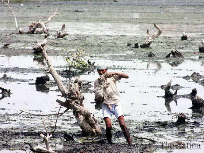
Dying mangroves in Indus Delta Photo: The Nation
Inam states : “Currently the Indus river hardly contributes any sediment to the delta or Arabian Sea.The active delta is reduced from 6200 km2 before construction of dams to 1200 km2. The sea water has travelled upstream upto 75 kms, combined loss of freshwater and sediment has resulted in loss of large areas of prime delta agricultural land and submergence of several villages in the coast. This has caused desertification and displacement of several hundred of thousands of local residents. Study of records and bathymetric maps from 1950 indicate widespread coastal retreat…The life on the delta is dependent on availability of freshwater and sediment. Severe reduction of both as a result of dams and barrages and associated structures in the upstream has resulted in pronounced erosion in parts of the delta and reduction in mangroves. Environmental studies to be extended to the entire Indus ecosystem from the mountains to the Arabian sea.”
Conclusions
It is clear that deltas and dependent populations and ecosystems have suffered due to near total ignorance about the impact of dams on sediment and deltas and if immediate action is not taken then, this will impact a huge population and a large eco-region in Indian subcontinent, as elsewhere.
The impacts of nutrient rich sediment retention and flow reduction is not limited to teh delta, but has also affected marine fish production[32]
The issue of impact of a dam on the sediment regime of the river is not being studied or considered at all while conducting Environmental Impact Assessments of projects, appraising the project for options assessment, environmental clearance, cost benefit analysis or through post clearance monitoring and compliance.
Sediment release and sediment transport through rivers is not being raised in trans-boundary river negotiations.
Looking at the severity of the issue and its far reaching impacts on millions of people in India and across the world, there is a need for adopting urgent and strong mitigation measures against sediment trapping in dams.
It has to be remembered that for older dams, older hydropower projects and most irrigation projects, there is no mechanism available to flush the accumulated silt.
Sediment retention also reduces the life of the dam, while starving the river and delta in the downstream of sediment. As per a study by SANDRP in 2006, India may be losing 1.95 Billion Cubic Meters of Storage capacity of its reservoirs annually.[33] This implies that the rivers are losing at least that quantity of sediment annually.
The frantic dam activity in Indian Himalayas at this moment will have a serious impact on Ganga Brahmaputra Delta in India and Bangladesh and Indus Delta in Pakistan. There is an urgent need to, firstly, acknowledge these links, assess the impacts, include them in cost benefit and options assessment, address the issues and implement mitigation measures, where relevant, abandon the projects where impacts are unacceptable projects unviable.
In case of the Ganga Brahmaputra delta, recent studies have indicated that the main source of sediment in the river is the Himalayas[34]. Of the entire sediment load of Ganga catchment (This study assumed it to be 794 million tonnes/year), 80+/-10 % comes from High Himalayas and 20+/-10 % comes from Lesser Himalayas.
Bumper to bumper dam/ hydropower project building is occurring in almost all of the Himalayan states in India, which is poised to make Indian Himalayas most densely dammed region in the world. All of these dams are located in the downstream of the Greater and straddling Lesser Himalayas and can together have a tremendous impact on Ganga’s sediment load. Uttarakhand is planning and building nearly 336 Hydroelectric projects,[35]while Sikkim and Himachal Pradesh too are building hundreds of hydro projects. Arunachal Pradesh intends to dam most of its rives to produce hydropower.
No studies on impact of these projects on sediment regime of the rivers are being carried out for; neither does the MoEF insist that projects will not be cleared unless such studies are carried out. Even Cumulative impact assessments are not assessing this aspect.
Some stark examples:
The Cumulative Impact Assessment Report of the Upper Ganga Basin in Uttarakhand [36](where more than one hundred dams are planned and under construction back to back) was doen by IIT Roorkee. This cumulative impact assessment did not study any cumulative impacts due to reduced silt load of the river following major dam push.
The Lohit Basin Study done by WAPCOS[37]which involves more than 12 dams across the Lohit River, one of the three main segments that form Brahmaputra, does not mention anything about impacts of dams on sediments. The only thing it states is very worrying : “Due to substantial storage capacity, the Demwe Upper reservoir will have high sediment retention capacity and a large proportion of sediments carried by the Lohit River will get settled in the reservoir.”
Siang Basin Study [38](by RS Envirolinks Pvt Limited), which involves three mega dams across the main stem Siang, completely obliterating free flowing stretches in the river,in addition to 42 hydropower dams, does not mention anything about sediment regime, although being specifically asked to address this issue by the Expert Appraisal Committee, Union Ministry of Environment & Forests (MoEF).
1500 MW Tipaimukh Mega Dam near Bangladesh Border, which has received Environmental Clearance from MoEF does not study the impacts of sediment retention on downstream Bangladesh, and this concern has been raised by the groups in that country. The Environment Management Plan of this project which can submerge 25000 hectares of forests does not even mention the word “sediment”.
The bumper to bumper dam building activity in Himachal Pradesh in Satluj, Beas, Chenab and Ravi [39]rivers will have a major impact on silt load reaching the Indus river Basin and the Indus Delta in Pakistan. However, none of the EIAs or EMPs mention any impact of the dams on the sediment regime of the river.
In conclusion, although the risks of delta subsidence, effective sea level rise and its impact on a huge population and ecosystems has been established, these risks are being entirely ignored in the current governance surrounding rivers and deltas.
National Centre for Sustainable Coastal Management It is unfortunate to see that MoEF’s National Centre for Sustainable Coastal Management, supported by MoEF and World Bank does not allude to this issue or raise it through any publications.[40] In conversation with SANDRP, Director R. Ramesh said that the center may look at these issues in the future. However, its publications on National Assessment of Shoreline Changes on Tamilnadu and Odisha[41] do not mention upstream dams, although robust evidence exist that Cauvery delta and Mahanadi, Brahmani and Baitarni deltas are eroding due to sediment retention. Let us hope this institute will try to highlight the impact of dams on deltas with the seriousness it deserves.
Recommendations
1. Urgently study impacts of sediment retention by dams on delta population and ecosystems: MoEF, Ministry of Rural Development and Urban Development should conduct an in-depth study to understand the scale of the problems and the extent of affected people and ecosystems due to sediment impoundment by upstream dams.
2.Urgently study the optimal level of sediments (and water regime) needed for stabilising deltas and reducing subsidence.
3. Urgently institute a study to assess the extent of sediment and flows needed to be released from upstream dams and feasibility of such releases on regular basis, mimicking the river’s hydrograph. Where dams have sluice gates, these should be opened in monsoons where feasible, to allow sediment flushing. Even in dry and stressed river basins like Colorado in the United States, such high releases for redistributing sediments have been conducted in the 1990s and again in 2013 with proper planning and impact assessment.[42]
4. In Krishna and such other basins, where delta subsidence, coastal erosion and related impacts like salinity intrusion and storm surges has reached serious proportions, specifically problematic dams should be considered for decommissioning.
Environmental Appraisal Process
Study of impact on sedimentation and siltation should be a part of the environmental impact assessment, environmental appraisal and clearance process.
There should be a separate section in EIA for e-flows and sedimentation studies. Similarly such studies should be mandatory part of cumulative impacts, carrying capacity and basin studies.
More dams in basins which support large deltaic populations and those having significant impacts of sediment retention by reservoirs should not be cleared.Let us hope that this chronically neglected issue receives the attention it deserves. Delta subsidence and ESLR due to upstream damming again highlights the complex and interconnected nature of the riverine ecosystem. The environmental governance in India ( as also South Asia) surrounding rivers has been treating rivers with an extremely piecemeal approach. It is clear that with the herculean challeneges we face now, such an approach is no longer affordable.
~~~~
…especially in the part called Delta, it seems to me that if the Nile no longer floods it, then, for all time to come, the Egyptians will suffer – Herodotus, History, c 442 BC (stated in Patrick McCully’s Silenced Rivers)
For PDF file of this blog, see: https://sandrp.in/Shrinking_and_sinking_delta_major_role_of_Dams_May_2014.pdf
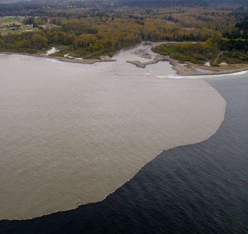
Above: Sediment laden waters of River Elwha reaching the coastal waters after Elwha Dam Removal. From: gallery.usgs.gov
Bibliography
Patrick McCully, Silenced Rivers: The Ecology and Politics of Large Dams, Zed Books, 1996
Islam et al, The Ganges and Brahmaputra rivers in Bangladesh: basin denudation and sedimentation, Hydrological processes, 1999
R.J. Wasson, A sediment budget for the Ganga–Brahmaputra catchment, Current Science, 2003
B Hema Mali et al, Coastal erosion and habitat loss along the Godavari Delta Front: a fallout of dam construction (?), Current Science, 2004
Syvitski et al, Impact of Humans on the Flux of Terrestrial Sediment to the Global Coastal Ocean, 2004
Jason P. Ericsson, Charles J. Vörösmarty S. Lawrence Dingmanb,2Larry G. Ward Effective sea-level rise and deltas: Causes of change and human dimension implications, 2006
Michel Meybeckve et al Sea-level rise and deltas: Causes of change and human dimension implications
Inam et al The Geographic, Geological and Oceanographic Setting of the Indus River, Wiley and Sons, 2007
Walling et al, The Changing sediment loads of world’s rivers, Annals of Warsaw University of Life Sciences, 2008
Syvitski et al, Sinking deltas due to human activities, Nature Geoscience, 2009
Gamage et al. Do river deltas in east India retreat? A case of the Krishna Delta, Geomorphology, Volume 103, Issue 4, 15 February 2009
K Nageswar Rao et al Impacts of sediment retention by dams on delta shoreline recession: evidences from the Krishna and Godavari deltas, India, Earth surface processes and landforms, 2010
James Syvitski et al, Sediment flux and the Anthropocene published 31 , doi: 10.1098/rsta.2010.0329 369 2011 Phil. Trans. R. Soc. A, January 2011
H Gupta et al , The role of mega dams in reducing sediment fluxes: A case study of large Asian rivers, Journal of Hydrology, 2012
[6] The role of mega dams in reducing sediment fluxes: A case study of largeAsian riversHarish Guptaa,⇑, Shuh-Ji Kaoa,b, Minhan Daia
[7] Sediment flux and the Anthropocene James P. M. Syvitski and Albert Kettner January 2011, published 31 , doi: 10.1098/rsta.2010.0329 369 2011 Phil. Trans. R. Soc. A
[8] Effective sea-level rise and deltas: Causes of change and human dimension implications
Jason P. Ericsona, Charles J. Vörösmartya,b,1, S. Lawrence Dingmanb,2Larry G. Ward
b, Michel Meybeckve Sea-level rise and deltas: Causes of change and human dimension implications Jason P. Ericson a,⁎, Charles J. Vörösmartya,b,1, S. Lawrence Dingmanb,2Larry G. Ward b, Michel Meybeck
[9] Walling and Fang (2003), Vörösmarty et al., 2003; Syvitski et al.,(2005), Erisson et al, (2005), Walling (2008)
[10] Syvitski et all 2009
[11] Sinking deltas due to human activities, Syvitski et al, 2009, Nature Geoscience
[12] Sinking deltas due to human activities, Syvitski et al, 2009, Nature Geoscience
[13] Ericsson et all, 2006, Effective sea-level rise and deltas: Causes of change and human dimension implications
[14] Sinking deltas due to human activities, Syvitski et al, 2009, Nature Geoscience
[15]Syvitski et al 2009
[16]Syvitski et all 2009
[17] Harish Guptaa, et al The role of mega dams in reducing sediment fluxes: A case study of large Asian rivers
[20] K Nageshwar Rao et al, 2010, Impacts of sediment retention by dams on delta shoreline recession: evidences from the Krishna and Godavari deltas, India Earth surface processes and landforms
[22] K Nageshwar Rao et al, 2010, Impacts of sediment retention by dams on delta shoreline recession: evidences from the Krishna and Godavari deltas, India Earth surface processes and landforms
[23] Time period or age
[24] Do river deltas in east India retreat? A case of the Krishna Delta Nilantha Gamage Geomorphology, Volume 103, Issue 4, 15 February 2009, Pages 533–540
The state of Assam in the northeastern India annually bears the brunt of floods and where embankment construction and repairing seems like permanent affair. Displacement of people living on the banks of rivers due to river bank erosion is another major issue here. The braiding and meandering river Brahmaputra and its tributaries continue to erode the banks rapidly. The Brahmaputra is well known for the rate in which it erodes. Among the places in the path of the river where the brunt of erosion has been felt severely include the following:
– Rohmoria and Dibrugarh town in Dibrugarh district,
– Matmora in Dhakukhana subdivsion of Lakhimpur district,
– Majuli and Nimati Ghat in Jorhat district,
– Lahorighat in Morigaon district and
– Palashbari and Gumi in Kamrup district.
Map of areas taken up for erosion protection in Assam. Source– Assam 2011, A Development Perspective, published by Planning and Development Dept., Govt. of Assam
SANDRP recently traveled to Matmora and Nimati ghat, two of these areas.
Bearing the Brunt of Erosion Silently Once a large village now only the name Matmora remains. Locals show us towards the middle of the river, to indicate where the village used to be. The rate of erosion is such that the Brahmaputra dyke from Sissikalghar to Tekeliphuta (popularly known as Sissi-Tekeliphuta dyke/embankment) takes the shape of a bow for nearly five kilometers at this place. From 2010, Matmora became very significant in the embankment history of India since country’s first embankment using geo-textile technology was constructed here. This was constructed at the bow shaped eroded line using geotextiles tubes. These tubes were filled up using water and sand from the banks of the river. This five kilometer embankment became a part of the Brahmaputra dyke from Sissikalghar to Tekeliphuta which is 13.9 km long. For the state government and Water Resources Department (WRD) of Assam, Matmora geotube embankment is a story of success of preventing floods and erosion. But what we saw in Matmora presents a different picture.
At Nimati Ghat, the river Brahmaputra is eroding its banks ferociously and people are intimidated by the river. A local person whose village used to be nearly two kilometers from the present bank line, told me, “Nothing can stop Baba Brahmaputra from claiming what he wants”. At Nimati Ghat, the Water Resources Department (WRD) is doing anti erosion work using geo-bags.
Funding for Embankments in Assam The total length of embankments in Assam is 4448 km as stated in a debate in the Legislative Assembly of Assam in 1998. Even though the present length of embankments is not known, it is very clear that the state of Assam continues to construct of newer embankments. In a recent analysis by SANDRP, it was found that the funds continue to increase for construction of embankments in the state. In five years from January 2009 to December 2013, the Advisory Committee in the Union Ministry of Water Resources for consideration of techno-economic viability of Irrigation, Flood Control and Multi-Purpose Project Proposals (TAC in short) had given clearance to projects worth Rs 1762.72 crores. A detailed list of these sanctioned projects can be found in Annexure 1 below.
Matmora Geo-tube embankment after its construction in 2010. Source– Assam 2011, A Development Perspective, published by Planning and Development Dept., Govt. of Assam.
Has Geo-tube been helpful for the people Between January 2009 to December 2013, the Brahmaputra dyke from Sissikalghar to Tekeliphuta, was considered twice by the TAC. The committee in its 95th meeting on 20th January 2009 accepted the project titled “Raising and Strengthening to Brahmaputra dyke from Sissikalghar to Tekeliphuta including closing of breach by retirement and anti-erosion measures (to protect Majuli and Dhakukhana areas against flood devastation by the Brahmaputra, Lakhimpur district, Assam). The estimated cost of this project was Rs 142.42 crore and its project proposal envisaged – (i) Raising and strengthening of embankment for a length of 13.9 km, (ii) Construction of retirement bund with geo-textile tubes of length 5000 m. (iii) Construction of 2700 m long pilot channel.
Geo-tube embankment in Matmora, three years after construction. Photo: SANDRP.
Protection work of the same dyke was considered in the 117th meeting held on 21st March 2013 under the proposal for “Protection of Brahmaputra dyke from Sissikalghar to Tekeliphuta at different reaches from Lotasur to Tekeliphuta from the erosion of river Brahmaputra Assam.” The estimated cost of this project was Rs 155.87 crore. According to the minutes of 117th TAC meeting, the scheme envisaged “restoration of existing embankment in a length of 15300m at upstream and downstream of existing geo-tube dyke, Sand filled mattress in a length of 15604 m at river side slope, geo-tube apron length of 7204 m and Reinforced concrete porcupines as pro-siltation device at different reaches to prevent floods and erosion in Dhakukhana Civil sub-division of Lakhimpur district and Majuli sub-division of Jorhat district.” In the same minutes,while referring to the previous project proposal of 95th meeting the minutes stated that, it “was taken up primarily for closure of breach in the existing embankment including raising of embankment around the breach area only. The proposed works in the present scheme were in the same river reach and these would be required to protect the bank from further erosion and provide flood protection.”
This clearly shows that the geo-tube embankment in Matmora cannot be called a success. Government documents which showed that major part of the Brahmaputra dyke from Sissikalghar to Tekeliphuta remained vulnerable even after the construction of the geo-tube embankment. In fact submitting a proposal for the whole Sissi-Tekeliphuta embankment at first and later saying that the money was spent in constructing a smaller part of the embankment also raise questions. The time gap between the two proposals also raises questions. If the whole money from first proposal was to be spent in constructing only a part of the embankment, why was it not stated clearly in the first proposal? In fact, this was not stated in the first proposal and second proposal reflects that the first project failed to achieve the objectives. If the first proposal was indeed only for part of the embankment, why the proposal to strengthen the larger part of the embankment took 5 years to appear before the committee? The latter proposal also did not mention about the breach which swept away a large part of the Sissi-Tekeliphuta embankment from Jonmichuk to Amgiri Tapit under Sissikalghar and Jorkata village panchayat. According to the local people this breach occurred in the morning hours of 25th June 2012. The photo below shows the breach happened at the Jonmichuk end.
The breached area of 2012. This photo is taken from the new embankment and the lake formed at this spot can also be seen. Photo – SANDRP
Jonminchuk area is nearly 15 km upstream of the geotube embankment in Matmora and part of the Sissi-Tekeliphuta embankment. A new embankment of nearly four kilometer long is being constructed at this place but the remnants of the old embankment still exist. The embankment was breached for nearly 3 kms and the water which entered the fields during that time could no longer go out and a large lake has been formed at this place, see the photo. It was surprising to see people living in the patches of the old embankment.
In the downstream, right from the point where the geo-tube embankment ends, the condition of the Sissi-Tekeliphuta embankment is pathetic. There were cracks in the embankment and water seepage has almost shattered the embankment. The embankment was in need of urgent repairs.
Condition of the Sissi-Tekelphuta embankment at the end point of the geo-tube embankment towards the village side. Photo – SANDRPSissi-Tekelphuta embankment at the same spot mentioned above towards the river side. Photo – SANDRP
Besides, one does not have to travel far to find erosion in the downstream of the geo-tube embankment. After travelling, less than three kilometers from the end point of the geo-tube embankment, rapid erosion was observed at the place where the Matmora and Tekeliphuta ghats join, due to low water level. This joint ghat is more than a kilometer from the toe line of Sissi-Tekeliphuta embankment but seeing the rapidity of the erosion the locals opine that the river would reach the toe of the embankment within this monsoon. It was difficult to believe that the river can erode so fast, until a young man pointed towards a black line in the middle of the river and said that that area which now seemed to be char/sand bar used to be his village three years back. He with his family now live beside the embankment. In this ghat we also witnessed that spurs constructed from the embankment inside the river, mainly to divert the flow of water, have been eroded as well.
The Spur has also been eroded. Photo – SANDRPErosion at Matmora-Tekeliphuta Ghat. Photo – SANDRP
It is also important to note that protection of Majuli from floods was one of the main aims of the geo-tube embankment project, but there were reports of devastating floods affecting Majuli in 2012 & 2013.
After geo-tube comes geo bags With the construction of geo-tube embankments being hailed as a success by the state government, construction of embankments using geo-bags followed. Geo-bags are smaller than geo-tubes and come at a cheaper cost. Embankments on many rivers were constructed using geo-bags which were also used for erosion protection. But effectiveness of the geo-bags as protective measure to flood and erosion, still remains disputed. A news report titled “ADB, river engineers differ on geo-bags” published in Assam Tribune on 9th September 2010 reported about the difference of opinion among the water resource engineers of Assam and powerful lobby of the Asian Development Bank (ADB) for the use of geo-bags to resist Brahmaputra erosion in Palasbari-Gumi and Dibrugarh. Referring to the engineers the news report stated “They have alleged that the ADB provided 23,000 geo-bags for an experiment. They were dumped in the month of September 2009 at a 150-metre-long selected erosion-prone reach at Gumi for testing their efficacy. But, a diving observation made in the month of December 2009, suggested that the bags were not launched uniformly in a single layer as it was claimed. They were found lying in a haphazard manner in staggered heaps with gaps in between and the total distance they covered was only about 8 metres, against the claimed and required 35 metres…..The ADB then carried out another diving observation at Gumi in May last (2010) and found no bag at the site. The State WRD did not get any feedback from the ADB on this issue.”
Work of piling up the geo-bags is going on in Nimati Ghat. Photo – SANDRPStatus of the geo-bags put last year. Photo – SANDRPThe spot where not a single Geo-bag was seen. Photo – SANDRP
Nimati Ghat was the other place which SANDRP visited to find out the effectiveness of geo-bags. The work of piling up the geo-bags for erosion protection was going on when SANDRP visited the area in the second week of April 2014. The bags which were used previously for the same purpose were seen to be mostly lying in water in shattered condition. Locals told us that majority of the bags are now under water. In the eroded bank line, these geo-bags were lying without any order and in a way suggesting how the river has dealt or to say played with these jumbo bags. In this bank line, there was a stretch of nearly five meters where the river has eroded more than the other parts. At this stretch none of the geo-bags were to be seen.
There were also contradictions regarding when the present erosion protection work at Nimati ghat had started. Some of the shopkeepers of the ghat said that the work of putting up geo-bags started in February 2014. But according to the contractor in charge of the work, the work started in November 2013. Construction or repairing of embankment just few months before the advent of monsoons is one of the constant criticisms, leveled against the Water Resources department of the state and in Nimati too we heard the same complaint.
Is Geo-tube really a ‘permanent solution’ to floods? In the present discourse of floods in Assam this has become a very significant question. The local people have been fed with various information about geo-tube and most of which are wrong. The life of embankment constructed using geo-tube is of 100 years, we were told by the locals when we travelled to the upstream areas of Matmora geo-tube. This is absolutely not true. In fact, for Prof Chandan Mahanta of IIT Guwahati the scouring[1] done by the river Brahmaputra will be the major cause of concern for geo-tube embankments in the long run.
The geo-tube embankment has already faced threat of scouring right after its construction in the monsoons of 2011. It was on the morning of 14th July, 2011 when two of the apron tubes at the tail of the embankment, were launched due to increase force of water. The apron tubes were laid at the toe of the geo-tube embankment and with the increased force of water scoured at the bottom by the embankment toe line. WRD engineers flung into action and immediate repairing work was taken up at the site. According to WRD engineers this had happened because the trees which were left outside the embankment had obstructed and increased the force of water and they were immediately cut down. Concrete porcupines were also thrown into the water. Asomiya Pratidin, a regional newspaper reported this on that day but thereafter no report on this could be found. The incident was almost forgotten. When we visited the geo-tube embankment, it was observed that along the toe-line of the embankment a scour line runs for substantial length of the embankment. This clearly shows that scouring by the river has increased in this area. The news report published in Assam Tribune [2]also points out a significant problem associated with geo-bags – “The lobby is mounting pressure for use of geo-bags in the form of bank revetment. Bank revetment is generally not adopted in Brahmaputra because of many reasons. Most important of them is – it produces a permanent deep channel along the existing riverbank.”
On the issue of lobbying behind geo-tube, an interesting perspective was provided by activist-researcher Keshoba Krishna Chatradhara who coordinates ‘Peoples’ Movement for Subansiri and Brahmaputra Valley (PMSBV)’. He opines that the construction of geo-tube embankment in Matmora was an experiment, done to see whether such embankments can withstand the flood and erosion of Brahmaputra. The reason for choosing Matmora first and not other severe erosion affected places like Dibrugarh or Rohmoria, was because even if the embankment fails it won’t be as significant loss for the state compared to those places. Dibrugarh is one of the most important towns of upper Assam with a glorious history whereas Rohmoria became important for the state when Oil India Limited found oil deposits in Khagorijan[3]. Infact several local people and activists also opined that the Sissi-Tekeliphuta embankment which is on the north bank of the river was cut several times, to save the areas in the upstream south bank, mainly the Dibrugarh town. They said that in the past, before the geo-tube embankment came, whenever there was any news of water rising in Dibrugarh, there would soon be a breach in Sissi-tekeliphuta embankment. In fact considering these breaches in the larger Sissi-tekeliphuta embankment, Mr. Chatradhara opined that even if the geo-tube embankment survives the flood, erosion and breaches in future, it might become a small island in midst of a submerged land as there will surely be breaches in the rest of the Sissi-Tekeliphuta embankment.
ADB loan for Geo-textile Embankments in Assam After the construction of the geo-tube embankment at Matmora, the state government is leaving no stone unturned to make it sound like a glorious success. But it is surprising to know that, even before the Matmora embankment was commissioned in December 2010, the state government have filed proposal for two more embankment project where geo-textile would be used for construction and got it cleared. The two subprojects of Assam Integrated Flood River Bank Erosion Risk Management Project (AIFRERM) in Dibrugarh and Palashbari were cleared in the 106th meeting of TAC held on 16th September 2010. It is important to note that for the total AIFRERM project ADB is giving a loan of $56.9 million. The cost of Dibrugarh and Palashbari subprojects are Rs 61.33 crore and Rs 129.49 crore respectively. But these investments have been cleared without even doing a post-construction impact assessment of Matmora geo-textile embankment. The Palashbari subproject also included erosion protection for Gumi area through the use of geo-bags but the Assam Tribune report quoted above already mentioned about how geo-bags scheme has failed in that area.
It is important to note here that, the first geo-tube embankment has been constructed only three years back and it would be premature to give any verdict of success, on the contrary there are many signs of failure. But the state government of Assam and the Assam Water Resources department are claiming it as success without really any credible basis and than have used that self certification to go on building more embankments using geo-textile and in several occasions these plans have failed. They first should have done a detailed impact assessment of the embankment at Matmora before going on building more embankments of the same nature.
It seems the Assam government, ADB and CWC are pushing these projects to deflect attention from the failure of embankments in flood management. Such attempts won’t succeed, but it is possibly a ploy to prolong the use of embankments as a flood management technique.
Parag Jyoti Saikia (meandering1800@gmail.com)
Annexure 1
Flood and Erosion Projects approved for Assam – 2009 to 2013
TAC meeting no & date
Project
Appr. year
River/ Basin
L of Emba. (m)
Original (revised) Cost-CrRs
Benefitting area (Ha)
Decision
95th -20.01.2009
Protection of Sialmari Area from the erosion of Brahmputra
2002
Brahmaputra
NA
14.29 (25.73)
NA
Accepted
Protection of Bhojaikhati, Doligaon and Ulubari area from the erosion
2002
Brahmaputra
NA
14.52 (27.92)
NA
Accepted
Raising & strengthening Brahmputra Dyke from from Sissikalghar to Tekeliphuta including closing of breach by retirement and anti erosion measures
New
Brahmaputra
NA
142.42
NA
Accepted
96th -16.02.2009
Flood protection of Majuli Island from Flood and Erosion Ph-II & III
New
Brahmaputra
NA
115.03
NA
Accepted
Restoration of Dibang & Lohit rivers to their original courses at Dholla Hattiguli
New
Brahmaputra
NA
23.32 (53.11)
NA
Accepted partly & suggested that proposal of coffer dam, pilot channel, etc. to be put up for expert opinion
101st -30.11.2009
Raising and strengthening to Puthimari embankment
New
Brahmaputra
NA
30.23
15000
Accepted
Anti Erosion measures to protect Brahmputra Dyke on left bank
New
Brahmaputra
NA
27.97
5000
Accepted
Protection of Gakhirkhitee & adjoining areas from erosion
New
Brahmaputra
NA
19.06
20,000
Accepted
102 -28.1.’10
Emergent measures for protection of Rohmoria in Dibrugarh District
New
Brahmaputra
NA
59.91
18,000
Accepted
106th -16.09.2010
Raising and strengthening of tributary dyke along both banks of Kopili River
New
Kopilli/ Brahmputra
NA
110.72
NA
Accepted
Assam Integrated Flood River Bank Erosion Risk Management Project
New
Brahmaputra
NA
61.33
NA
Accepted
Assam Integrated Flood River Bank Erosion Risk Management Project
New
Brahmaputra
NA
129.49
NA
Accepted
110th – 20.07.2011
Protection of Majuli from Flood and Erosion Ph II & III
2011
Brahmaputra
115.03
Accepted
Restoration fo rivers Dibang & Lohit to their original courses at Dholla Hatighuli
2011
Brahmaputra
54.43
Accepted
111th – 17.08.2011
Protection of Biswanath Panpur including areas of upstream Silamari and Far downstream Bhumuraguri to Borgaon against erosion
New
Brahmaputra
167.09
Accepted
117 – 21.3.’13
Protecion of Sissi-Tekeliphuta dyke from erosion – Lotasur to Tekeliphuta
New
Brahmaputra
153000 m
155.87
153000 m
Accepted
118th – 30.07.2013
Flood management of Dikrong along with river training works on both banks embankment
New
Dikrong/Brahmaputra
105.96
Accepted
Flood management of Ranganadi along with river training works on both bank embankments
New
Ranganadi/Brahmaputra
361.42
Accepted
[1] Scour can be termed as a specific form of the more general term erosion. In case of geo-tube embankments Scour is the removal of sediment from the bottom of the geo-tubes. Scour, caused by swiftly moving water, can scoop out scour holes, compromising the integrity of a structure.
[3] See ‘Rohmoria’s Challenge: Natural Disasters, Popular Protests and State Apathy’ published in Economic and Political Weekly, Vol XLVI NO 2, Janurary 8, 2011.
At least 49 large[1] hydropower projects are under construction in India today, with a cumulative capacity of 15006 MW[2]. As per the latest bulletin from Central Electricity Authority[3], “Status of Hydro Electric Projects under Execution for 12th Plan & beyond (Excluding projects above[4] 25 MW)” dated March 31, 2014, 35 of these projects (9934 MW) are expected to be commissioned in 12th Five Year Plan[5] and remaining 14 with installed capacity of 5072 MW would provide benefit beyond 12th Plan.
Considering that 1534 MW capacity has already been added in first two years of ongoing 12th Five Year Plan (during 2012-13 and 2013-14), CEA projections means that India hopes to add massive 11468 MW capacity during the current five year plan. This will be higher than capacity added in any other five year plan and 254% of the capacity addition during the last, 11th Five Year Plan (2007-12) when India added 4514 MW. The graph below shows how steeply our hydropower installed capacity is going up over the last 25 years.
Rapidly Increasing installed capacity of Large Hydropower Projects in India
The proponent of even more accelerated hydro capacity addition misleadingly talk about the need for having 40% of installed grid capacity as hydro.
In line with this, the CEA came out with plans to add 65000 MW in 13th Five Year Plan (2017-2022: 30 000 MW) and 14th Five Year Plan (2022-2027: 35 000 MW). (see http://www.energylineindia.com/ of May 6, 2014)
There is no science behind this advocacy. It is basically a suggestion possibly based on the general assumption that peaking demand is 40% higher than base-load demand. Hence if we have 40% installed capacity from hydro in the grid, this can take care of total demand optimally. However, this is based on assumption that hydro capacity is indeed used for peaking. This assumption is completely wrong in India, with no agency monitoring or even reporting how much of the hydro generation currently provide peaking power. Without such optimum use of current hydro capacity, where is the case for 60:40 grid capacity ratio for hydro? It goes without saying that when hydro projects are used for peaking power, there are additional social and environmental impacts in the downstream and upstream. These need to assessed and those who suffer are compensated.
On similar lines, one can answer the advocacy for claim that hydro is clean, green, renewable and cheap source of power or that run of the river or small hydropower projects are more environmentally benign. However, this blog is not attempting to answer all such fallacies here, it needs a separate blog.
While this is happening, the Expert Appraisal Committee of Union Ministry of Environment and Forests on River Valley Projects has been clearing projects at break a neck speed with almost zero rejection rate. Between April 2007 and Dec 2013, this committee recommended environment clearance to 18030.5 MW capacity, most of which has not entered the implementation stage. Moreover, this committee has recommended 1st Environment clearance (what is technically called Terms of Reference Clearance) for a capacity of unimaginable 57702 MW in the same period. This is indicative of the onslaught of hydropower projects which we are likely to see in the coming years.
Figure 1 TORs (First Stage EC) and EC recommended by EAC between April 2007 – December 2013
Table: Sector-wise & plan-wise number of & capacity of under construction HEPs
Sector
During 12th FYP
After 12th Plan
Total
No of Projects
Installed capacity, MW
No of Projects
Installed capacity, MW
No of Projects
Installed capacity, MW
Central
11[6]
5312
3
2615
14
7927
State
12
1506
3
736
15
2242
Pvt
12
3116
8
1721
20
4837
Total
35
9934
14
5072
49
15006
Among the three sectors, the largest number of under construction projects (20) are from private sector. However, among all sectors of under construction projects, central sector projects have the highest installed capacity (7927 or 53% of under construction capacity of 15006 MW).
Figure 2 Sectorwise ownership of under-construction HEPs in Numbers
Vulnerable Himalayas are the target In the second table the state-wise and sector-wise break of numbers and capacity of under construction HEPs has been given. Himachal Pradesh has the highest number and highest installed capacity projects among all states. That state also has the highest installed capacity (8139 MW or over a fifth of operating HEP capacity at national level) of large operating hydropower projects. Sikkim, however, has the highest number and capacity of private sector hydropower projects under construction. In fact, half of the total national-level private sector projects which are under construction are in that tiny state. Their installed capacity is more than half the installed capacity of all the private sector hydropower projects under construction at national level. Ironically, the state also has the highest biodiversity in the country.
Figure 3 Installed Capacity of under construction HEPs, sector-wise ownership, in MW
Himachal Pradesh and Uttarakhand also have 5 and 3 private sector HEPs under construction respectively. The 5 Himalayan states of Jammu & Kashmir (J&K), Himachal Pradesh, Uttarakhand, Sikkim and Arunachal Pradesh between them have 38 of the 49 under construction hydropower projects with total capacity of 13550 MW or over 90% of under construction capacity. In addition, the projects of Mizoram, Meghalaya, W Bengal (Teesta L Dam IV) and Punjab (Shahpur Kandi on Ravi River) are also in Himalayan zone.
Table: State-wise & sector-wise number and capacity of under-construction HEPs
State
Central Sector
State Sector
Private Sector
Total
No of projects
Installed Capacity, MW
No of projects
Installed Capacity, MW
No of projects
Installed Capacity, MW
No of projects
Installed Capacity, MW
J&K
1
330
1
450
1
850
3
1630
Himachal P
4
2532
6
956
5
460
15
3948
Uttarakhand
4
2135
–
–
3
505
7
2640
Sikkim
–
–
–
–
10
2622
10
2622
Arunachal P
3
2710
–
–
–
–
3
2710
Mizoram
1
60
–
–
–
–
1
60
Meghalaya
–
–
1
40
–
–
1
40
W Bengal
1
160
–
–
–
–
1
160
Punjab
–
–
1
206
–
–
1
206
Madhya Pr
–
–
–
–
1
400
1
400
Maharashtra
–
–
1
80
–
–
1
80
Andhra Pr
–
–
3
410
–
–
3
410
Kerala
–
–
2
100
–
–
2
100
Total
14
7927
15
2242
20
4837
49
15006
Figure 4 State-wise and sector-wise number of HEPs under constructionFigure 5 State-wise installed capacity of under construciotn HEPs
Diminishing Returns This blind rush for hydropower projects (which have serious and irreversible impacts on social and ecological systems) is difficult to understand and justify considering their poor generation performance, rising costs and availability of better options. To illustrate, in the graph below we can see how power generation per unit (MW) installed capacity has been steadily reducing over the last two decades. From 1993-94 to the latest year of 2013-14, there has been a huge drop of 16.5%.
Diminishing power generation from India’s Hydropower Projects over the last two decades
Yawning gap between promised and actual generation of Hydro Projects Another way to look at performance of hydropower projects would be to compare the projected (as promised in Techno Economic Clearance) and actual generation (both at 90% dependability) of electricity by HEPs. This assessment shows that about 89% of India’s operating hydropower projects are generating at below the promised levels. Shockingly, half of under performing projects are generating at below 50% of promised generation levels.
How much Peaking Power are we generating? A third way to assess the hydropower generation is in terms of peaking power, a USP[7] of hydropower projects. However, no figures are available as to how much of the generation from hydropower projects are happening during peaking hours. No agency in India is even monitoring this or reporting this: including CEA, Central or State Electricity Regulatory Authority, National, Regional or State Load Dispatch Centers, Union or state Power Ministries or individual operators. In short, there is no case for justifying more hydro in the name of providing peaking power if we are neither monitoring nor optimizing hydropower generation during peaking hours. One expected CEA to do this job, but it seems they are busy lobbying for hydropower projects rather than functioning as India’s premier Technical Power sector agency.
Invitation to disaster? The consequences of such massive capacity addition are and will continue to be disastrous for the rivers, forests, biodiversity and people. The Uttarakhand disaster of June 2013 has shown the vulnerability of hydropower projects in Himalayas, as well as their impacts. The disaster and independent reports[8] also show how the construction and operation of these projects have contributed to compounding the proportion of the disaster. Climate Change is accentuating this situation and will continue to do so with increasing intensity as per the IPCC reports.
Role of HEPs in Uttarakhand disaster: CEA and CWC in denial mode This analysis of under construction hydropower projects as reported in the latest CEA bulletin shows that Himalayas is the target for overwhelming majority of hydropower projects being taken up India (& neighbouring countries like Bhutan, Nepal, Pakistan and Tibet). The Uttarakhand disaster showed how hydropower projects are increasing the existing vulnerabilities and disaster potential of the Himalayan region in times of natural calamities. An independent committee appointed by MoEF following Supreme Court orders of Aug 13, 2013 pointed out the role of hydropower projects in Uttarakhad disaster of June 2013.
It should be highlighted here that multiple hydropower projects should invite cumulative impact assessment. As Supreme Court order of Aug 13, 2013 highlighted, such cumulative impact assessment need to be done in a credible way and not the way AHEC of IITR did for the Bhagirathi-Alaknanda basin.
Strangely, instead of accepting this reality and taking this into account in decision making processes, Central Water Commission and Central Electricity Authority are in a denial mode! They collectively submitted a completely unscientific and unfounded report to Union Environment & Forests Ministry, advocating for hydropower projects rather than assessing their role in disaster, which was the mandate given by Supreme Court of India to MoEF. The CEA is clearly jeopardizing whatever credibility it has in joining hands with CWC. It would be better for both the agencies to accept and wake up to these realities.
Else, such onslaught of hydropower projects on Himalayas is likely to be an invitation to further disasters all across the Himalayas. All our decision makers and all others concerned need to take note of this urgently.
[4] In reality, this should be “below”, we have italicized the word since the error is in the original.
[5] Ending on March 31, 2017
[6] CEA projects that out of 2000 MW installed capacity of Lower Subansiri HEP in Arunachal Pradesh, 1000 MW will be commissioned in 12th Plan and the rest of 1000 MW thereafter.
The protagonists like to equate large dams with development. Those who suffer the adverse consequences equate them with displacement, deforestation, deprivation & debt. While the protagonists see dams as drought proofing measure, critics have for long associated dams with drying up of rivers, destruction of biodiversity and depletion of groundwater in downstream areas. The debate has been going on for long, but we have seen little change in the way decisions about dams are taken. There is little democracy there. The dissent almost invariably is dealt with repression.
So there are a lot of d-words associated with dams. Two new words have now have joined that long list: Deception and Delusion. The negative conclusions about dams have come in recent weeks from two reputed international forums: Oxford University research and Report of the Inter-governmental Panel on Climate Change (IPCC).
Oxford University’s Atif Ansar, Bent Flyvbjerg, Alexander Budzier & Daniel Lunn have published in 2014 a research paper titled “Should we build more large dams? The actual costs of hydropower mega-project development. Energy Policy”. The paper is based on evidence based research and “outside view, applied to large dams for the first time here”. After analyzing data from 246 large dams commissioned between 1934 and 2007 from all over the world, looking at all kinds of dams and objectives of the dams, they have concluded that there is inherent systematic psychological delusion and political deception on the part of officials in deciding to take up large dams. This results in underestimating the costs, construction periods and over estimating the benefits, putting a question mark about the selection of correct options. They suggest that “decision-makers’ forecasts, and hence ex ante judgment, are often adversely biased”, leading to mega dams typically facing adverse outcomes.
The authors suggest that there is need to “Create transparency on risk profiles of various energy alternatives, from not only the perspective of financial cost and benefit but also environmental and social impact – hard evidence is a counter – point to experts’ and promoters’ oft-biased inside view.” This is exactly in line with what we have been suggesting here in India in functioning of various decision making forums. The authors in fact conclude, “Projects with a poor cost and schedule performance are also likely to have a poor environmental and social track record. A greater magnitude of cost and schedule overruns is thus a robust indicator of project failure… This result suggests that developing countries in particular, despite seemingly the most in need of complex facilities such as large dams, ought to stay away”.
Bhama Askhed Dam in Maharshtra, canal systems not ready despite 2 decades of work. Photo:SANDRP
This phenomenon of delusion and deception is best illustrated in India by the Sardar Sarovar Project in Gujarat. The project that started with cost estimates of Rs 6406 crores is far from complete when close to Rs 50 000/- crores have already been spent. The corruption involved in this project will be known only when there is a credible independent scrutiny of the expenses; the current regime is totally against even independent lokpal or use of RTI. The full social and environmental impacts of the project are still not known. The most touted benefit of the project: drought proofing Kutch, Saurashtra and North Gujarat is now not even part of the Gujarat government agenda and mind you, there was no agitation against building canals in these regions. In stead water is being taken away for unplanned and unjustified utilization for urban and industrial use. And now the project is used to push political agenda of constructing the world’s highest statue.
There are many other instances that exemplify the delusion and deception in decisions on dams in India. The Maharashtra irrigation scam and white wash of it by the Chitale Commission is one of the recent examples. The non transparent, non participatory and unaccountable functioning of the Advisory Committee in the Union Ministry of Water Resources for consideration of techno-economic viability of Irrigation, Flood Control and Multi Purpose Project Proposals (TAC in short) is a perennial problem. The Khuga and Thoubal irrigation projects in Manipur, both initiated in 1980 are still ongoing and have seen cost escalations of 28 and 35 times the original costs, but the TAC has been clearing all such claims without any questions! Same is the case of Dhansiri irrigation project in Assam, started in 1975, still ongoing with cost having gone up by over 36 times the original cost!
Dhansiri Project on Dhansiri RIver, Assam. Photo: Jayanta Kumar Das, Panoramia
In fact it is not secret even for Planning Commission that Major and Medium Irrigation Projects are not delivering any benefits for over last two decades now to the net irrigated area. In case of hydropower projects, the installed capacity has gone up exactly twice in last two decades, from 20275 MW in 1993-94 to 40524 MW in March 2014, but generation per MW installed capacity has gone down by over 16% during this period, but no questions are asked!
The second significant adverse comment on dams came from the IPCC’s second working group report of the fifth Assessment, made public on March 31, 2014. The report has a number of significant references on how large dams perform in changing climate. This lead to the conclusion that Dams and infrastructure projects contribute significantly to “non-climate impacts” which, after interacting with changing climate, exacerbate the overall impact on human societies and ecosystems. Climate change and dams together affect a greater eco-region; Sediment Trapping by reservoirs exacerbates impact of sea level rise. In case of Flood Protection, dams and embankments may do more harm than good & Ecological measures would fare better. Dams and Hydropower projects affect biodiversity, which is critical in facing climate change challenges; In the tropics, global warming potential of hydropower may exceed that of Thermal Power; Dams increase vulnerability of weaker sections to climate change & that Hydropower itself is vulnerable to Climate Change. This again is not exactly breaking news, we have been raising these issues with Ministry of Environment and Forests, its Expert Appraisal Committee and others. Now that IPCC has said this, the official agencies will take note of this.
In face of such clear evidence of role of big dams and big hydropower projects in changing climate, there is no dearth of proponents selling hydro projects as clean, green, cheap and renewable, including some environmental groups like Centre for Science and Environment.
As India goes to polls, the least one can expect that the election manifestoes and promises of the parties seeking mandate to rule would pledge to take a hard look at the performance of big dams in India and take corrective steps as required. In stead we have statements from BJP prime ministerial candidate saying North East India is heaven for hydropower development and they would take up Inter-linking of rivers in big way. The Congress has no different agenda. Even the Aam Aadmi Party, unfortunately has refrained from taking any clear stand on this issue. It seems the people have a long road of struggle ahead.
Drop 23 projects, do cumulative assessments & improve governance
In a significant development on role of hydropower projects in Uttarakhand flood disaster of June 2013, the Expert Body (EB) headed by Dr Ravi Chopra has recommended that at least 23 hydropower projects should be dropped, that hydropower projects played significant role in the Uttarakhand disaster and that there is urgent need to improve the environment governance of hydropower projects. The Report “Assessment of Environmental Degradation and Impact of Hydroelectric Projects During The June 2013 Disaster in Uttarakhand” dated April 2014 has been submitted to the Union Ministry of Environment and Forests on April 16, 2014 and was made public following hearing in the Supreme Court on April 28, 2014. The committee was appointed by a reluctant Union Ministry of Environment and Forests (MoEF) in October 2013, following the Supreme Court’s suo motto order of August 13 2013.
Damaged Vishnuprayag Dam in Uttarakhand floods of June 2013: Source: MATU Jansangathan
Uttarakhand floods of June 2013[1],[2]: The committee report endorses the stand taken in a letter[3] that was written to MoEF on July 20, 2013, endorsed by over 20 individuals and groups including from Uttarakhand on the role of existing and under construction hydropower projects in the Uttarakhand floods of June 2013. MoEF did not take any action on this letter, but it was Supreme Court order next month that pushed MoEF to take necessary action.
SC order of Aug 13, 2013[4]: On Aug 13, 2013, while disposing off the petition on Srinagar HEP in Uttarakhand, the Supreme Court, suo motto, made an order that asked, MoEF and Uttarakhand governments not to provide any further clearances to any more hydropower projects anywhere in Uttarakhand till further orders. Both MoEF and Uttarakhand governments have been violating this order. However, one of the fall outs of this order was formulation of Expert Body appointed by MoEF more than two months latter, through an order on Oct 15, 2013, whose report now is available in public domain.
Limited TOR[5]: The Supreme Court order of Aug 13, 2013 pertained to whole of Uttarakhand, as was the disaster of June 2013. However, the MoEF order and subsequently CWC tried to restrict the field of work of the committee to Alaknanda and Bhagirathi sub basins rather than whole of Uttarakhand.
Problematic constitution: The constitution of the Expert body was also problematic from a number of aspects. There was clear conflict of interest with respect to some of the members like Dr BP Das, former member and Vice Chair of the MoEF’s Expert Appraisal Committee on River Valley Projects, as explained below. The committee also included chairman of Central Water Commission and Central Electricity Authority, which unfortunately act like lobbies for hydropower projects. These persons were in the committee to bring in respective expertise, but in stead used their presence in the committee to discredit evidence which suggested clear role of hydropower projects, some members also advocated for more hydropower projects, in stead of adhering to the mandate given by the Supreme Court, thus raising the issue of contempt of court.
In what follows we have given some useful recommendations and conclusions of the EB, followed by some weak recommendations and conclusions of the EB report, based on a quick reading of the report (we got the over 200 page report only on April 29, 2014), following by some remarks on role of vice chair, CWC, CEA, MoEF and our conclusion.
Map of Mandakini Valley, epicenter of Uttarakhand floods of June 2013 (Source: EB report)
On 24 projects recommended to be dropped by WII “After considerable discussions and analysis, the Expert Body concluded that of the 24 proposed Hydropower Projects (HEPs) that Wildlife Institute of India (WII) recommended for Review, 23 HEPs would have significant irreversible impacts on biodiversity values.”
“The EB recommends that for the 23 proposed HEPs out of the 24 identified by WII (other than the Kotli Bhel 1A project) that would have irreversible impacts on the biodiversity of Alaknanda and Bhagirathi Basins, the HEPs that fall in any of the following conditions should not be approved for construction.
(a) Proposed HEPs that fall inside wildlife Protected Areas such National Parks and Wildlife Sanctuaries
(b) Proposed HEPs that fall within the Gangotri Eco-sensitive Zone
(c) Proposed HEPs that fall above 2,500m that encompass critical wildlife habitats, high biological diversity, movement corridors, and fragile in nature due to unpredictable glacial and paraglacial activities.
(d) Proposed HEPs that fall within 10 km from the boundary of Protected Areas and have not obtained clearance from the National Board for Wildlife.”
It would have been in fitness of things if EB had exclusively asked for stoppage of work on all these 23 projects with immediate effect.
On Kotli Bhel 1A The EB has, we believe, erroneously concluded, over ruling the conclusion of WII and expert review initiated by EB, “that the Kotli Bhel 1A project might not significantly worsen the condition of the river Bhagirathi between Koteshwar and Devprayag – already part of a highly fragmented zone”. However, EB has asked for “due modifications to its design and operations so that an adequate stretch of the river downstream of the Koteshwar dam just above KB-IA can be maintained in a free flowing state”. This means the project work should stop and it should reapply for clearances after doing the suggested modifications in credible way.
Restoration: “The river bed profiles at Phata-Byung, Singoli-Bhatwari, Vishnuprayag and Srinagar HEPs have changed significantly. This requires a fresh analysis of the project hydrology and redesigning them if necessary.
All projects must undertake river restoration works after prior clearance from MoEF. It was noticed that project developers were engaged in projects’ restoration only. MoEF needs to conduct a formal review of the environmental damages at all the HEPs in Uttarakhand and prepare guidelines for restoration. Till then none of the projects should begin power production.”
HEPs above 2 MW need EC “All projects > 2 MW, shall require prior Environmental Clearances (EC) from MoEF”.
“A multidisciplinary expert body should be constituted with members of proven expertise and experience to review every year the progress/performance of each HEP and its compliance with the sanction conditions. This body will also review the technicalities of disaster preparedness before each monsoon season and examine the impact of monsoon storm and floods on the performance of all the project components. The environmental health of the river will be a critical area for comprehensive examination.”
No projects above winter snow line “Learning from the June 2013 event, the EB believes that the enhanced sediment availability from and in paraglacial zones could be a serious problem for the longevity of the existing, under construction and proposed HEPs in Uttarakhand. Therefore the EB recommends that the terrain above the MCT in general and above the winter snow line in particular (~2200-2500 m) should be kept free from hydropower interventions in Uttarakhand.”
SIA should be carried out for all river systems in Uttarakhand “The WII study has already identified 24 proposed HEPs in the Alaknanda and Bhagirathi basins as likely to cause irreversible impacts. But comprehensive research studies of other basins in Uttarakhand are lacking at this stage… Strategic Environmental Assessment (SEA) be carried out in other major river basins of Uttarakhand such as the Yamuna and Kali basins.”
Distance between projects in a cascade “Scientific studies by subject experts should be conducted for establishing baseline data on river parameters, diversity and populations of floral and faunal species in different rivers of Uttarakhand at different elevation zones. Such studies should be used for deciding upon the minimum distances between two consecutive HEPs. Until such scientific studies are completed, no new HEPs (in S&I stage) should be cleared on the rivers of Uttarakhand within a distance that may later be revoked. Minimum distances for projects in the clearance stage should be significantly revised upward from the current consideration of 1 km.”
SANDRP Map of Bumper to Bumper hydropower projects in Alaknanda basin in Uttarakhand
National Himalayan Policy “Since the Himalaya are our vital source of growth and abundance, a National Himalayan Policy needs to be urgently created and implemented.”
“Therefore, the EB strongly recommends that a detailed study of the impacts of hydropower projects in terms of deforestation/tunneling/ blasting/reservoir formation on the hydrogeology of the area should be carried out.”
A study on the role of large artificial reservoirs on local climate change and precipitation patterns with special reference to the Tehri dam reservoir.”
Sediment transportation studies “Recent studies have highlighted serious concern about the Indian deltas, which are shrinking due to changes in river courses. The Ganga-Brahmaputra delta is also noted in this category. This seems to be a major issue in near future therefore we recommend that the studies should be carried out regarding the impacts on sediment transportation due to projects existing on Himalayan rivers.”
Cultural impacts of HEPs “Therefore EB recommends that the Ministry of Culture along with the local representatives and spiritual leaders should undertake a comprehensive study of the cultural impacts of HEPs in the spiritually rich state of Uttarakhand.”
“The river bed profiles at Phata-Byung, Singoli-Bhatwari, Vishnuprayag and Srinagar HEPs have changed significantly. This requires a fresh analysis of the project hydrology and redesigning them if necessary.”
“River Regulation Zone (R.R.Z.) guidelines should be issued immediately by the Ministry of Environment & Forests and should be executed accordingly.”
Muck Management: “The existing practices of muck management are inadequate to protect the terrain and the people from an eventuality like the June 2013 flood. Therefore, a serious revisit is required towards evolving technically better and ecologically sustainable methods for muck disposal and rehabilitation in Uttarakhand.”
Environmental Flows: “Till such time as a decision is taken on the EFlows recommendations of the IITs-consortium, the EB recommends EFlows of 50% during the lean season and 30% during the remaining non-monsoon months. Sustaining the integrity of Uttarakhand’s rivers and their eco-systems is not negotiable.”
Eco-Sensitive Zones: “It is recommended that legislation be enacted to (i) protect small but significant rivers (as done in Himachal Pradesh and also recommended by the IMG for Uttarakhand) as pristine rivers and (ii) designate Eco-Sensitive Zones for all rivers of Uttarakhand.”
Community based CA and CAT “Community-based CA and CAT plan execution must be done by the State Forest Department within the construction period of the project.” This is to be monitored by a committee that includes two representatives from local communities, a renowned environmentalist, among others.
Forests and Biodiversity Conservation: “Community based CAT programmes have to be systemically implemented for ensuring sustenance of the plantations. This requires training of forest officials to work with the communities through their Van Panchayats.”
“It was brought to the notice of the EB that clearances to start work had been granted recently to the Lakhwar (300 MW) and Vyasi (120 MW) projects. This is in violation of the spirit of the Hon’ble Supreme Court’s order of August 13, 2013. It is also noticed that these projects were approved more than 25 years ago. Consequently they do not have any EIA/EMP/DMP studies that are mandatory today. Without conducting cumulative impact assessments and disaster management studies of the Yamuna and Kali basins no such projects should be allowed at the risk of fragile ecology, biodiversity and lives of people living in and around the project sites.”[6]
SOME WEAK RECOMMENDATIONS OF EB
“The EB recommends that MoEF strengthens its personnel and procedures for post-sanction monitoring of environmental conditionalities. The MoEF should develop a programme for research studies by reputed organizations on the impacts of HEPs on river water quality (and flows). Pre-construction and post operation long term impacts monitoring studies are required.”
Geology & Social Issues: “Given the massive scale of construction of HEPs in Uttarakhand it may be worthwhile to set up a formal institution or mechanism for investigating and redressing complaints about damages to social infrastructure. The functioning of such an institution can be funded by a small cess imposed on the developers. It is also suggested that to minimize complaints of bias, investigations should be carried out by joint committees of subject experts and the community.”
Disaster Management: “Disaster preparedness is critical because all of Uttarakhand lies either in seismic Zone IV or V. These areas are most vulnerable to strong earthquakes. Disaster Management Plans (DMPs) are critical parts of EIA Reports. They need to be carefully reviewed and approved by local communities in the probable zone of influence.”
“It is necessary to establish an independent authority which may commission EIA Reports…”
CONCLUSIONS OF EB:
On Role of Dams in Uttarakhand disaster:
In Chapter 3 (p 10) chairman of EB notes, “Thus THDC’s inundation analysis results could
not be substantiated by the ground survey in Haridwar city.”
“In September 2010, to retain flood inflows in the face of water levels rising beyond the permitted FRL the (Tehri) dam authorities had to seek the permission of the Supreme Court. It led to inundation of the upstream town of Chinyalisaur and later after draw down fresh landslide zones were created around the reservoir rim.”
“Geo-chemical analysis of sediment samples taken from various locations along the river stretch in Srinagar, however, indicated a significant contribution — varying from 47% near the barrage to about 23% much further downstream (Fig. 3.19, pg 101, Main Report) — from muck eroded from muck disposal sites 6 and 9 located on the concave right bank and consequently experienced an intense current of the order of 7m/sec.
This raises a question that if there was heavy to very heavy rainfall from the glacial reaches of the Alaknanda valley, leading to numerous landslides along the banks, then why was massive damage observed only downstream of the Vishnuprayag and Srinagar HEPs? A detailed investigation is warranted in order to arrive at a scientifically viable explanation.”
“Otters appear to be nearing extinction in the Ganga, Alaknanda sub-basins.”
It is good to see that the EB has effectively rejected the critique of the WII report presented by Dr. Sabyasachi Dasgupta, HNB Garhwal University and consultant to UJVNL, following an independent review of the WII report by Prof. Brij Gopal, an eminent ecological scientist who had worked extensively on river ecosystems. Prof Brij Gopal, while finding some limitations in WII methodology, concluded: “he agreed with WII’s findings that the 24 proposed hydropower projects would impact the biodiversity of Alaknanda and Bhagirathi basins significantly. Based on his own analysis, Prof Gopal recommended that several more projects be dropped.”
SOME WEAK CONCLUSIONS:
“A ground survey of the inundation analysis carried out by THDC on the basis of which it claimed to have saved Haridwar from drowning raised doubts about the accuracy of the computer generated inundation maps. It is therefore not clear how much of Haridwar would have been affected if the Tehri dam had not been there. The problem at Haridwar, as at other towns and habitations along river banks, is that there has been wide spread encroachment and construction inside the river’s regime. Therefore it is imperative to set up river regulation zones where encroachments are forbidden. (Unscientific sand mining on river beds adds to the problem.)”
“There is some doubt about whether the Vishnuprayag project authorities were able to properly manage the opening and closing of the gates.”
Role of Dr B P Das: Dr B P Das has for close to a decade been member or vice chair or officiating chair of the Expert Appraisal Committee of MoEF on River Valley project and has in the process been involved in appraising and deciding on clearances for a no of projects and their impacts in Uttarakhand. Hence he was not likely to be in a position to take an independent view on Uttarakhand hydropower projects as there was a conflict of interest involved with respect to his earlier decisions. His biased views were also known through his article in The Hindu earlier. This got reflected in the alternate view on page 27 of chapter 3 and page 16-17 of Chapter 4 of the report authored by Dr Das. In Chapter 3 box, Dr Das’s abiding faith in the project developer could be seen. In Chapter 4 box Dr Das himself mentions that EAC has yet to take a view on WII report, but the he himself is a responsible party for EAC not having taken a view on WII report.
Role of CWC, CEA chairpersons: CWC (Central Water Commission, India’s premier technical body on water resources development under Union Ministry of Water Resources) and CEA (Central Electricity Authority, India’s premier technical body on power sector are largely known to act as lobbies for hydropower projects, in stead of the independent technical and regulatory body that they are expected to work as. In view of that, inclusion of chairperson of CWC and CEA in this committee was wrong step on the part of MoEF. We learn from a letter written by two eminent members of the committee, namely Dr Shekhar Pathak and Dr Hemant Dhyani on March 27, 2014, that indeed the chairpersons of CWC and CEA did not really participate in the way they were required to, and rather functioned in violation of the Supreme Court order.
Scanned version of last part of the letter of 27.03.2014 from Dr Shekhar Pathak and Dr Hemant Dhyani, members of EB
Role of MoEF: One had expected that the EB would take a critical view of the functioning of the MoEF around HEPs and contribution of MoEF’s failures in increasing the disaster proportions. Unfortunately we are disappointed in this. Possibly, with the committee having been appointed by MoEF and member secretary of the committee being MoEF official this was a difficult ask. However, not being able to take a critical stand on the role of MoEF (and other institutions like CWC, CEA, state environment department, state disaster management department etc) imposes a limitation on the EB report and provides a free reign to guilty party. The consequences of this became apparent when on April 28, 2014, during the Supreme Court hearing, we are told, the MoEF presented erroneous picture that there are two reports of the committee, one by 10 members(wrongly called activists) another by Vice Chair B P Das, with CWC and CEA chair persons, when at best the note from these three persons can be considered dissent note, that too in violation of SC orders. We hope the Supreme Court will take strong view of this misleading picture presented by MoEF and reprimand the responsible officials to ensure that this does not happen again.
View of the Committee working through its minutes
Minutes of the 2nd, 3rd and 4th meeting are available on the MoEF, Lucknow regional office website. Perusal of the minutes shed light of the functioning of the committee, and the biases of some specific members. Some highlights from the minutes:
THDC, Tehri and Muck Disposal Sites: Site visit reports of various members, including Dr. Amit Gupta, Dy Director of MoEF presented that THDC is managing active and non active muck disposal sites ‘poorly’. The sites do not have proper retaining wall, slop or plantations.
THDC hid drift tunnel of Koteshwar dam: Member Hemant Dhyani exposed that THDC officials did not accept the presence of a huge drift tunnel of Koteshwar Project near Payal Gaon, which was suffering from severe subsidence. Only when the local people, including the tunnel construction workers insisted that there is a tunnel that the THDC officials accept this fact!
In the 3rd meeting, the Chief Secretary of Uttarakhand told the committee that projects with EC or FC should not be closed or stopped. Note here that this suggestion is unacceptable when the SC itself has asked the committee to investigate the role of projects in the flood damages.
To top this, Additional Chief Secretary unilaterally asserted that HEP did not have any role in the mishap. He emphasised every Environmental CLearance needs an EIA. This indicates his poor knowledge about the quality of EIAs which has been accepted by most experts.
He further stressed that a umber of FC cases were peding before the MoEF. Moef official YK Singh Chauhan rebutted this claim.
In the 4th Meeting, Dr. B.P. Das, Co Chair of the committee categorized June event as a rare natural calamity and attributed the losses only to road construction ( Incidentally, many roads are being built for hydel projects, and do not even allow access to local communities.)
Dr. Ravi Chopra, Chairperson highlighted the poor data management of THDC. He highlighted that THDC could not provide HFL data, rainfall data, inlet level from Maneri Bhali II and outlet level sought by the committee members.
Conclusion: In spite of certain weaknesses, most of the recommendations of the committee need to be immediately implemented and till they are implemented in letter and spirit, the Supreme Court should order a status quo on any further hydropower projects. The EB headed by Dr Ravi Chopra should be congratulated for this report in spite of difficult circumstances under which the committee operated.
Þ We also hope the Supreme Court would ask MoEF to order stoppage of work on Lakhwar and Vyasi projects that has been started recently, violating the Supreme Court order in letter and spirit, and also as pointed out by the EB.
Þ The work on 24 hydropower projects that was part of explicit TOR of the committee should be ordered to stop immediately. The EB should have made this explicit recommendation, but even if they have not done that, it is implicit in its recommendation.
Þ The Supreme Court should ask MoEF to provide a time bound action plan on implementation of the various recommendations of the EB. The SC an also possibly appoint EB (minus Dr Das, CWC and CEA persons) to oversee the implementation of the action plan and continue to provide independent feedback on adequacy of such implementation.
Þ The Lessons from Uttarakhand are relevant for all Himalayan states of India from Kashmir to all the North East states and we hope Supreme Court to ask the follow up committee to ensure that these lessons are taken note of and necessary steps flowing there from are implemented in these Himalayan states. These will also provide guidance to our Himalayan neighbouring countries.
Þ The failure of environmental governance is one of the clearest stark message from this episode and we hope MoEF will put its house in order in this respect, revamping its entire environmental governance.
[7] Reuters report on this issue: http://in.reuters.com/article/2014/04/29/india-flood-idINL6N0NL0VC20140429
[8] The section “View of the Committee working through its minutes” has been put together by SANDRP colleague Parineeta Dandekar. I am also thankful to her for other useful suggestions from her.
Sardar Sarovar Dam Stilling basin damaged: No repairs for 3 years:
No meeting of Dam Safety Panel for 30 months:
WHY IS GUJARAT NEGLECTING SAFETY OF ITS LIFELINE?
Sardar Sarovar Dam: (Photo by SANDRP)
Gujarat government, Gujarat politicians and their supporters never tire of telling the world that the Sardar Sarovar Dam (SSD) on Narmada River is their lifeline. Shockingly, perusal of recent official documents obtained under RTI indicate that Government of Gujarat (GOG) and its Sardar Sarovar Narmada Nigam Limited (SSNNL) are least bothered about the issues of the very safety of the SSD.
The only technical body that is supposed to be in charge of safety of the dam, namely Dam Safety Panel (DSP), has remained non existent for years together while the official reports show that the structures like stilling basin that are a part of the dam have suffered such serious damage that the Sardar Sarovar Construction Advisory Committee (SSCAC) and its Permanent Standing Committee (PSC) have repeatedly asked for attention. First they asked for urgent attention then immediate attention, then attention before monsoon to the repair, but still, there has been no response for a long time from GOG or SSNNL.
Shockingly, India’s premier technical body on water resources, Central Water Commission (CWC), was not taking interest in this issue ostensibly since they were not represented on DSP!
Who can say Sardar Sarovar Project is really Gujarat’s lifeline and that Gujarat government is bothered about the lifeline?
CHRONOLOGY OF EVENTS RELATED TO DAMAGE AT SSP DAM: In what follows, we have given the blow by blow chronology of events related to the damage to SSP Dam, all information taken from official documents obtained under RTI.
May 2011 The minutes of 101st meeting of PSC notes, “He (Representative of GOG) further informed that a team of nine officials from National Institute of Oceanography, Goa carried out inspection under water of stilling basin of SSP dam during 3rd May to 15th May 2011 and it was found that there is no damage except some erosion of size 3-5 cm at some places, which is not a serious problem.” Please note the description of what NIO found, as reported by GOG here and let us see how this description and implications change from “there is no damage except…” and “not a serious problem”.
It is this report of NIO that had discovered the damage to the SSP dam stilling basins and other underground parts, the damage must have happened during 2010 monsoon or earlier, and till March 2014 and as we write this, there is no confirmation of the repairs.
SSP Stilling Basin damaged in 1995 Photo: Frontline
June 8, 2011: 101st meeting of PSC notes: “The committee noted the progress of works and directed GOG to include the reports of National Institute of Oceanography, Goa in their quarterly progress report and also to take up remedial measures for the shortfalls indicated therein.” So PSC first asks for just necessary reports and remedial measures.
Feb 10, 2012: The minutes of the 102nd meeting of PSC notes: “Chairman suggested tat the observation of NIO may be taken seriously”. It calls for urgent steps for remedial actions on the recommendations of the NIO report and meeting of Dam Safety Panel at an early date in view of NIO report. If what NIO found was “no damage” and “not a serious problem”, as GOG reported to the 101st PSC meeting, why did PSC ask for URGENT meeting of DSP?
Moreover, the minutes of the meeting note: “The committee directed GOG to initiate urgent steps for remedial actions on the recommendations of NIO report.” The NIO report found, among other damages, “two big cavities noticed along with many minor ones” in Bay 5 and “RT[1] wall cavity at the bottom, where a small area which found disturbed, needs attention.” Damages were also reported from Bay 1, 2, 3 & 4 and divide wall and basin floor had cavities in all the bays, more in Bay 4 & 5.
March 16, 2012: The minutes of 79th meeting of SSCAC note: “… the NIO found minor cavities, loose pieces of concrete and broken iron rod pieces on the floor.” This description shows much more serious damage than what GOG reported to 101st meeting of PSC in June 2011. The Minutes of the 79th meeting of SSCAC go on to say: “SSCAC took on record the above fact and endorsed the decision of PSC for convening the meeting of Dam Safety Panel as early as possible and address the issue.”
So NIO finds damage in May 2011, but there is no meeting of DSP till March 2012. Then PSC (Feb 2012) and SSCAC (March 2012) recommend URGENT meeting of DSP. Note that PSC and SSCAC took nine and ten months respectively to recommend URGENT meeting of DSP. And yet, there is still no meeting of DSP for another 20 months!
Aug 23, 2012: The minutes of the 104th meeting of the PSC says: “it was decided that DSP meeting may be called up immediately and underwater inspection should be carried out after monsoon whenever high magnitude flood occurs.” Note the word “immediately”, since GOG had not responded to earlier URGENT recommendation. GOG still shows no urgency.
The GOG response, on reading of minutes of the 104th meeting of PSC appears most casual: “For conducting above mentioned DSP meeting, Shri Y K Murthy, Chairman DSP panel is being contacted to get the date convenient to him. However, meeting is getting delayed as Shri Y K Murthy is not keeping good health.” Shri Murthy, it may be noted, is close to 92 years old by now… and the meeting of DSP, immediately required since over two years, is not possible since this 90+ year old person is unable to give dates! In the meantime, as the minutes of the 104th meeting notes, two flood seasons (2011 & 2012) have passed and 2012 monsoon saw water level reach record level (till than) of 129.2 m on Sept 7, 2012 and dam overflowed for more than 50 days.
Oct and Dec 2012: Considering the seriousness of the situation at SSP, SSCAC wrote letters to SSNNL on Oct 25, 2012 (Ltr no SSC/PB/PSC-104/2012/3112) and Dec 7, 2012 (Ltr no SSC/PB/PSC-105/2012/3553) asking for the status of the action by GOG on recommendation of the 104th meeting of PSC that DSP meeting be called immediately. The GOG does not bother to respond to the letters. Could SSCAC, a statutory body chaired by Union Water Resources Secretary & set up under NWDT award have done better than just writing letters, when safety of country’s costliest dam?
Feb 20, 2013: On the agenda of urgent repair of SSP dam stilling basin and meeting of DSP, the minutes of 105th meeting of PSC record: “Representative of Gujarat informed the Committee about the sad demise of Dr Y K Murthy, Chairman of DSP and so DSP has become defunct. To get expert advise it is proposed that BOC constituted for Canal work can also act as DSP for Dam. Accordingly, they referred the matter to BOC[2].” PSC asked GOG to send a proposal about BOC for Canals being given the task of DSP and reminded: “The remedial action needs to be completed before the monsoon of 2013.” The remedial action did not happen before the monsoon of 2013 or before the end of year 2013 either. Nor did the meeting of DSP happened till Nov 2013, after the end of Monsoon 2013.
March 25, 2013: The minutes of the 80th meeting of SSCAC notes that there is still no progress. On the GOG proposal of entrusting the DSP work to BOC for canals, SSCAC reminds GOG that “as per CWC guidelines for the safety of the project, the constitution of DSP is must.” Nothing happens till the monsoon is well underway, even the constitution of the DSP does not happen till July 2013. This means that for over 30 months after NIO discovers damaged dam, there is not even a meeting of the DSP, leave aside any remedial action.
July 6, 2013: SSNNL reconstitutes DSP under chairmanship of Shri R Jayaseelan (he is also the chairman of Board of Consultants of SSNNL), a former CWC chairman. DSP was originally constituted through GOG resolution of 20.2.1986. The DSP constituted on July 1, 2010 was supposed to be functioning till June 30, 2013 with extended term and was chaired by Dr Y K Murthy. Born in Oct 1920, Dr Murthy was already 90 when the DSP chaired by him got this extended term. Dr Murthy too was chairman of CWC during 1977-78[3].
Aug 18, 2013: The GOG remains most casual on the subject of DSP meeting, as reported in the minutes of the 106th meeting of PSC: “GOG representative informed that meeting of DSP will be convened within this month as per the availability/ convenience of the Chairman, DSP”. The dam safety has to wait, of course, till the chairman finds time for the meeting.
Aug 29, 2013: A letter from SSNNL to Gujarat Engineering Research Institute explains possible reason for damage to stilling basin: “Due to uncontrolled flow passing over the spillway, hydraulic conditions which have not been considered in the design of spillway basin have developed. This has caused damage/ erosion in the stilling basin area… in the floor of stilling basin, junction of stilling basin floor and divide wall/ right training wall.” SSNNL must know these conditions are existing since 2006 when dam reached present level of 121.92 m and should have taken necessary measures, but not only they do not take any, but even after NIO report shows the damage in May 2011, they don’t take any action on it for over 30 months before calling DSP meeting and even longer to start repair work.
Nov 25-26, 2013: The 48th meeting of Dam Safety Panel (at last) happens. Its first agenda is: “Repairing of Concrete Panels of different bays of stilling basin of Sardar Sarovar Dam.” In the meantime, letter dated Nov 20, 2013 from Chief Engr (Dam and Vadodara), SSNNL to secretary SSCAC says: “Regarding safety measures for Stilling Basin, memorandum is prepared for repairing of Stilling Basin and submitted to the DSP for heir guidance by the Superintending Engr, N P Designs (Dams & Power House) circle, Vadodara.. DSP meeting will be called as per the convenience of the DSP members.” So 30 months after NIO discovered damaged dam stilling basin, SSNNL has prepared memorandum for repair and six days before scheduled DSP meeting, they feign ignorance about the date of the meeting!
Dec 18, 2013: The minutes of the 107th meeting of PSC says: “The Committee directed GOG to give top priority for repair of stilling basin before coming monsoon and keep ready the embedded parts required for at least one working season.”
The minutes also note what GOG reported about the DSP meeting on Nov 25-26, 2013: “It has been suggested that dewatering of bay No 4 & 5 shall be carried out at first instance & then inspection of damaged portion will be done by the DSP members. After inspection by DSP members, remedial measures will be suggested… Representatives of GOG informed the Committee that the procedure for carrying out above works will be started after receiving the final report of 48th Dam Safety Panel Report.” Dam repairs are still waiting for the DSP report, dewatering and inspection by DSP members!
March 28, 2014: Agenda note of the 81st meeting of the SSCAC throw light on lack of interest by CWC in this whole affair: “… it was observed that there was no participation from CWC in DSP and on enquiry it was learnt that they did not give this priority as they are neither invitee nor member in the DSP.” The key words are that CWC “did not give” dam safety of SSP priority!
Conclusion It is clear from the above sequence of events that serious damage was found in the stilling basin[4] of Sardar Sarovar Dam by NIO in May 2011. Till March 2014 (34 months after damage was discovered) and till as we write this, there is still no news that the damage has been repaired, even as the monsoon of 2014 is about six weeks away. In fact it took Gujarat government 30 months just to organize the dam safety meeting. That too after pushing and prodding from several meetings of Permanent Standing Committee of SSCAC and also meetings and letters from statutory SSCAC itself. This for the costliest dam of India. A dam about which the Gujarat government and Gujarat politicians never tire of telling the world that it is Gujarat’s lifeline.
Sardar Sarovar Dam with milestone showing 2 km distance (Photo: SANDRP)
Why did the central government (Please note that SSCAC is a body under Union Water Resources Ministry and is chaired by Secretary, Union Ministry of Water Resources) not do anything beyond writing letters and changing words from necessary to urgent to immediate and yet not doing anything when none of these words were heeded to?
Why did the premier water resources agency of India, CWC, not bother to do anything about this situation and did not take interest in Dam Safety Panel? Can CWC even be entrusted with the task of dam safety?
Why did SSNNL employ a person as old as 90 years to head an important body like Dam Safety Panel? Why did it take no action even as the chairperson reported sick then passed away dead ? Why did it wait for the chairperson’s term to be over before appointing a new Panel, again headed by a former CWC chief?
Is the Dam Safety Panel of Sardar Sarovar Dam a retirement perk for CWC chiefs? If Gujarat government cannot take necessary steps for the safety of Sardar Sarovar Dam, its claimed lifeline, then is this Government capable of taking any serious responsibility? Will the officers responsible for this state of affairs both in Gujarat and the Centre be identified and held accountable?
There are too many questions like these for which there seem to be no easy answers.
[4] A depression just downstream of the dam, deep enough and so structured as to reduce the velocity or turbulence of the flow and also channelise the downstream flow. The stilling basin is in fact integral part of the dam and without a safe stilling basin, a safe would not exist since an eroded and damaged still basin can expose the foundation of the dam to damage.
Imagine that a state government wants to build a Big Dam, with height of 31.75 m on a Big River. The River has already seen a large number of dams, agitations, controversies and legal disputes.
This dam is going to cost several hundred crores of rupees, just the initial civil works’ cost is Rs 299.43 Crores[1] out of approved construction cost (alone) of Rs 438.18 Crores[2].
But this dam will not provide any irrigation. Not supply any water to anyone. Will not do any flood control. Will not be a net generator of power. In short it can claim none of the benefits that a standard dam project claims.
And yet it will have fairly serious impacts. Hundreds of hectares of fertile, useful land will be destroyed. River itself and biodiversity of the river will be destroyed. In the downstream too there will be huge adverse impacts. Hundreds of tribal families will be adversely affected. Almost all of them have been affected by an upstream dam project. The government has refused to answer any of their concerns. The people are already agitated and have declared their opposition[3],[4] and have also legally challenged the project.
However, we do not know full social or environmental impacts of the dam, since such an impact assessment has never been done. The work on this project according to the government started in Feb 2013. Any such dam project would require impact assessment, management plan, public hearings, environmental appraisal, clearance, monitoring and compliance mechanism. But this one had none of it and does not want to do any of it! It does not have even a Rehabilitation Plan. Not even one on paper, as most such plans are.
Majority of the purported benefits of the project are supposed to legally go to another state, but that state has said it does not want the dam, nor does it want to share costs or benefits. And still the state government has started work on the dam.
We are used to telling a lot of bad dam stories. But this one seems to be a unique one.
Why does the state government want to build this dam? What are the benefits and for whom? Why is the Union Environment Ministry allowing such an illegal dam? Is this not dam fundamentalism?
Ok, enough of mystery. Let us understand what this project is about.
Garudeshwar Dam This story is about Garudeshwar dam[5] on Narmada River in Bharuch district in Gujarat. With height of 31.75 m, it is a major dam, since any dam above 15 m height is considered big dam by national and international definitions. The Garudeshwar Dam will create a huge 12 km long reservoir.
Ongoing work at Garudeshwar Dam site. Photo: SANDRPSardar Sarovar Dam in the upstream of Garudeshwar dam. Photo – SANDRPMap of Garudeshwar dam affected area. It also shows the Sardar Sarovar on right side. Photo: SANDRP
It is proposed just downstream from the most controversial Sardar Sarovar Dam Project (SSP). The SSP is being constructed under the Narmada Water Disputes Tribunal Award of 1979. The Garudeshwar Dam is proposed as part of the power component of the SSP, to act as downstream storage when the 1200 MW River Bed Power House (RBPH) of SSP will act in a Pump Storage Supply (PSS) mode. This means that Garudeshwar Dam’s basic function is to store the water released from RBPH during peak hour power generation. This water stored in the Garudeshwar dam is then to be pumped back to the SSP reservoir during off peak hours. Pumping the water back to the reservoir typically takes about 20% more power. This is in comparison with the power generated when a unit of water was released from the upstream dam (SSP in this case) during generation mode. It means that Garudeshwar Dam will be net consumer of electricity. This kind of project could have economic viability when there is additional tariff for power available during peak hours, which is not the case today. In absence of such valuation, such projects are not even economically viable.
According to the NWDT award, Madhya Pradesh gets majority, or 57% share in the power benefits (and costs) from SSP, Maharashtra gets 27% and Gujarat 16%.
Another objective of the Garudeshwar Dam[6] is to create a reservoir surrounding Statue of Unity, being propagated as the world’s highest statue on a small island 3 km downstream of the SSP Dam.
None of the required Statutory clearances obtained The minutes of the 80th meeting of SSCAC (Sardar Sarovar Construction Advisory Committee, the statutory interstate body to coordinate construction of SSP, it is chaired by Secretary, Union Ministry of Water Resources and includes senior officials of Gujarat, Madhya Pradesh, Maharashtra and Rajasthan, in addition to Narmada Control Authority) held in March 2013 notes on the issue of Garudeshwar Dam, “The work to be taken up by GOG in compliance of all statutory clearances. The committee accordingly directed GOG to take further follow up actions.” It was no secret to SSCAC that GOG had taken no clearances, how could then SSCAC wash its hands off with such a statement?
As per Supreme Court Order of Oct 2000 (Narmada Bachao Andolan vs Union of India and Others), as also earlier statutory orders under NWDT, the sanction of Rehabilitation Sub Group and Environment Sub Group of Narmada Control Authority is to be obtained prior to every stage of work related to SSP. No such sanction has been obtained by these authorities. In fact, as per letter written by Shekhar Singh, a member of ESG of NCA on March 24, 2013, there has not even been impact assessment of the Garudeshwar Dam, which is necessary before ESG can consider clearing the work on Garudeshwar work:
“Garudeshwar weir, to be built 12 km downstream of the SSP dam with a live storage capacity of 32.9 Million Cubic Meters is a component of the Sardar Sarovar Project, as was envisaged by the Narmada Water Disputes Tribunal Award of 1979. However, as far as I recollect, the environmental and social impacts of construction and operation of Garudeshwar weir (GW) have never been brought before the ESG of NCA. In my estimation, the construction and operation of the GW will have significant social and environmental impacts, since it will entail a reservoir of about 12 km in length and unknown width and submergence area. The weir will have the potential of affecting the fisheries in the immediately surrounding areas and also of affecting the downstream river and its biodiversity, and other related aspects. This is especially because the weir will control the flow of water and silt downstream. However, I do not know whether there has been a comprehensive assessment of the environmental and social impacts of the GW and its contribution to the cumulative impact of all the projects and activities in the area. And if there has been, I do not believe that this has been put up to the ESG for its approval.”
River Narmada from Indravarna village which will be affected due to construction of Garudeshwar dam. This image speaks volumes about Narmada, the river in reality and the river locked between two dams as there in the map. Photo: SANDRP
Similarly, since it is a work under SSP, the R&R policy of SSP is suppose to apply to the people affected by the Garudeshwar Dam. This also means that a R&R Plan have to be prepared and consent of the affected people taken and R&R completed a year before the construction work, which too has not been done, nor a sanction of RSG of NCA taken.
The reservoir upstream of the Sardar Sarovar Dam has been declared eco sensitive zone and protected area. The Garudeshwar Dam will create a reservoir that will be affecting the river close to the SSP Dam and thus will be within the eco sensitive zone and legally, such a work requires clearance from National Board of Wildlife, but such a clearance has not been taken.
Since Garudeshwar Dam is proposed in tribal area, consent of the gram sabhas is also legally required. No such consents have been taken.
Thus, the work that has been going on is completely illegal.
State benefiting the most, questions need for the Garudeshwar Dam Official documents obtained by SANDRP under RTI Act shows that GoMP has repeatedly shown their disagreement with the need for Garudeshwar Dam. Here are a few instances from official records. Strangely, in spite of this clear disagreement from a majority beneficiary state, the decision to go ahead with the project was taken by Gujarat and endorsed by SSCAC. The other statutory bodies like the Narmada Control Authority and its Environment Sub Group and Rehabilitation Sub Group were not even consulted.
June 2011 The minutes of the 101st meeting of the PSC of SSCAC held in June 2011 noted, “Summing up the discussion the Chairman observed that the extent of disagreement is now so acute that the very need of Garudeshwar Weir is being questioned.”
July 2011 The events thereafter moved rapidly. Following a request letter of GOG on July 21st, 2011, Secretary to Union Water Resources Ministry (also chairman of SSCAC and NCA) called a meeting of participating states on 25th July, 2011. At this meeting, Madhya Pradesh continued its disagreement with the need for the Garudeshwar weir, as recorded in the minutes of the meeting[7], providing reasons of their opposition: “The representative from Govt of MP also informed the stand of their government on the construction of the said weir mentioning that State of Madhya Pradesh will become surplus in power by the year 2014 and as such, Madhya Pradesh may not like to avail such a costly peak power. According to their calculations, the tariff for peak power may be more than Rs 6 per unit. In view of this, State of Madhya Pradesh is not in the favour of the proposal of the Garudeshwar Weir requiring the sharing of the cost of construction and the energy required for reversible operations.”
The response of the Secretary (MoWR) was strange[8], “GOMP to review their stand of surrendering their share of peak hour power generation by reversible operation on RBPH machines and confirm about the same for further course of action.”
The fact that GOG and Union Govt (even as opposite parties were ruling the state and the centre, showing amazing collusion of pro dam fundamentalism) were so much hand in glove that the secretary, brushing aside the objections of the majority beneficiary state of MP, decided to push unwanted dam down the unwilling state’s throat: “Secretary (MOWR) while concluding the meeting, stated that the construction of Garudeshwar Weir needs to be taken up urgently & completed expeditiously…”.
March 2012 The Government of Madhya Pradesh (GoMP) pointed out in their letter dated 21.03.2012 to SSCAC[9]), “there is no mention about Garudeshwar Weir in the NWDT Award”.
The GoMP also made it clear in this letter that GoMP does not concur with the proposal in view of “the change in power tariff scenario”.
Aug 2012: The 104th meeting of PSC of SSCAC records on this agenda Item no 104-5, “The representative of GOMP conveyed that, at this stage, they don’t agree with above decision and a note of dissent in this regard will be sent soon.”
So the state that was supposed to get 57% benefits and also pay same proportion of costs, has refused to concur with the scheme.
Status of work According to the Agenda notes for the 81st meeting of SSCAC held on March 28, 2014, till Dec 2013, 6.88% of excavation was the only physical progress on the Garudeshwar weir. Financial Progress achieved was even less, at 3.19%.
Some recent Developments:
Oct 2013 The affected people and eminent Gujarat citizens write to MoEF and GOG[10] to immediately stop illegal work on Garudeshwar Dam. Affected people and their leaders were put under house arrest when Chief Minister and former Deputy PM L K Advani came to the Kevadia Colony to lay foundation stone for the proposed Statue of Unity.
Jan 3, 2014 Gujarat Government[11] is considering use of force to suppress the movement against the illegal work on Garudeshwar Dam.
Jan 27, 2014 Tribal women of 70 villages to be affected by the Garudeshwar dam go to the site of ongoing work and ask the contractor to stop the work as it is illegal, without necessary clearances, impact assessments and consents.
Jan 31, 2014 National Green Tribunal order (Lakhan Musafir & Anr Vs. Sardar Sarovar Narmada Nigam Ltd and others – Application 10/2013 WZ): “We deem it proper to grant three (3) weeks time to Respondent No.1 to file reply affidavit and make it clear that in the meanwhile if any work done, it will be subject to final outcome of the present Application, without claiming any right of equity arising out of execution of construction work and without pleadings in advance of any ‘fait Accompli’.
Feb 25, 2014 NGT order: “Learned Additional Advocate General, seeks time to file comprehensive reply affidavit, as regards the nature of project in question. He submits that filing of such affidavit requires co-ordination of various departments and Agencies, which will take certain time. He, therefore, seeks reasonable time to complete the exercise of preparing reply affidavit. He undertakes to maintain directions as regards keeping of equity, in the light of earlier order dated 31st January, 2014.” The application next comes up for hearing on May 9, 2014.
April 1, 2014 People of 70 villages affected by Garudeshwar Dam hold protest demonstration in Vadodara.
April 14, 2014 Blasting at Garudeshwar village for the dam leads to rock fall on people, endangering lives of children and also shaking of houses.
A milestone on the way to Sardar Sarovar, with the dam in the background. Photo: SANDRP
Conclusion It is clear that Garudeshwar Dam does not have any justification, any impact assessment study, any required statutory clearances, any consents from affected Gram Sabhas and or even from the state which is supposed to get majority of the questionable claimed benefits. This dam seems like a symbol of Gujarat Government’s dam fundamentalism.
The reason as to why the Union Ministry of Environment and Forests is not taking action against this illegal work or why the Union Water Resources Ministry is supporting the work or why the political opposition in Gujarat is silent on this dam is still a mystery. However, under the current circumstances, the project must be stopped immediately. We hope NGT takes this step urgently. It is high time that political parties fighting elections in the area and Gujarat take a stand on this dam immediately.
Himanshu Thakkar (ht.sandrp@gmail.com)
END NOTES:
_________________________________
[1] “The letter of acceptance-cum-work order for the construction of Garudeshwar Weir across river Narmada near village Garudeshwar has been issued to agency M/s Rithwik Project Pvt Ltd, Hyderabad by SSNNL, Gandhinagar vide letter No. CPC/ Garudeshwar Weir/ 2011/657-P-II dated 04.05.2012”, as per Minutes of 104th meeting of PSC of SSCAC held on Aug 23, 2012.
[2] Minutes of 104th meeting of Permanent Standing Committee of SSCAC held on Aug 23, 2012, obtained by SANDRP under RTI.
[3] That the officials knew about the opposition is clear from the Gujarat Samachar clipping of Oct 22, 2012, carrying warning from affected people that if their issues are not settled, the work on the dam will be stopped. This clipping was included in the agenda notes for the 80th meeting of SSCAC held on March 25, 2013.
[4] The minutes of the 105th meeting of the PSC of SSCAC held in Feb 2013 noted on the issue of Garudeshwar dam, “The representative of GOG informed that work is delayed due to objection of the local peoples for giving better R&R package”.
[5] Calling is weir is clearly an attempt to mislead everyone, giving an impression that is a low dam, which it is not.